

Hail Map for Saturday, September 9, 2023

Number of Impacted Households on 9/9/2023
0
Impacted by 1" or Larger Hail
0
Impacted by 1.75" or Larger Hail
0
Impacted by 2.5" or Larger Hail
Square Miles of Populated Area Impacted on 9/9/2023
0
Impacted by 1" or Larger Hail
0
Impacted by 1.75" or Larger Hail
0
Impacted by 2.5" or Larger Hail


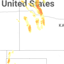


Cities Most Affected by Hail Storms of 9/9/2023
| Hail Size | Demographics of Zip Codes Affected | ||||||
|---|---|---|---|---|---|---|---|
| City | Count | Average | Largest | Pop Density | House Value | Income | Age |
| Fort Laramie, WY | 3 | 1.83 | 2.00 | 1 | $57k | $26.9k | 52.0 |
| Saint Francis, KS | 2 | 1.88 | 2.00 | 2 | $50k | $31.4k | 51.1 |
| Lingle, WY | 1 | 2.75 | 2.75 | 3 | $78k | $36.6k | 46.5 |
| Boise City, OK | 1 | 2.50 | 2.50 | 0 | $43k | $31.0k | 44.2 |
| Arnold, NE | 1 | 2.00 | 2.00 | 2 | $39k | $27.5k | 48.8 |
| Merna, NE | 1 | 2.00 | 2.00 | 3 | $39k | $31.3k | 42.8 |
| Veteran, WY | 1 | 1.75 | 1.75 | 3 | $471k | $26.7k | 42.3 |
| New Brunswick, NJ | 1 | 1.75 | 1.75 | 7314 | $123k | $36.0k | 23.3 |
| Oconto, NE | 1 | 1.75 | 1.75 | 1 | $26k | $27.3k | 48.8 |
| Douglas, WY | 1 | 1.75 | 1.75 | 3 | $88k | $39.7k | 38.0 |
| Hayes Center, NE | 1 | 1.75 | 1.75 | 1 | $34k | $26.9k | 47.0 |
Hail and Wind Damage Spotted on 9/9/2023
Filter by Report Type:Hail ReportsWind Reports
States Impacted
North Carolina, Virginia, New Jersey, Maryland, District of Columbia, West Virginia, Massachusetts, Georgia, Nebraska, Pennsylvania, Delaware, Texas, Kansas, New York, Oklahoma, Tennessee, New Mexico, Wyoming, Connecticut, South DakotaNorth Carolina
| Local Time | Report Details |
|---|---|
| 10:49 AM EDT | Thunderstorm winds blew down one tree near the intersection of smith loop and prospect church roa in caswell county NC, 48.4 miles NW of Raleigh, NC |
| 11:35 AM EDT | Tree down at rocky branch rd and poindexter s in forsyth county NC, 75.9 miles NNE of Charlotte, NC |
| 11:38 AM EDT | Utility company reports power outages due to fallen trees on power equipment on elbon dr and bowen blv in forsyth county NC, 71.2 miles NNE of Charlotte, NC |
| 11:56 AM EDT | Thunderstorm winds blew down one tree along the 5500 block of kerrs chapel roa in caswell county NC, 55.4 miles NW of Raleigh, NC |
| 12:24 PM EDT | One tree down from thunderstorm wind in stokes county NC, 57.2 miles SSW of Roanoke, VA |
| 12:57 PM EDT | One tree down on tody goodwin r in wake county NC, 17.9 miles WSW of Raleigh, NC |
| 1:15 PM EDT | Thunderstorm winds blew down one tree along mile marker 86 of the northbound lanes on interstate 7 in surry county NC, 74.3 miles N of Charlotte, NC |
| 2:26 PM EDT | Corrects previous tstm wnd dmg report from scotland neck. 911 call center reported trees and powerlines down along jr high school rd in scotland neck. time estimated by in halifax county NC, 72 miles ENE of Raleigh, NC |
| 2:29 PM EDT | Power outages were reported due to fallen trees on powerlines. time estimated by rada in halifax county NC, 72.2 miles ENE of Raleigh, NC |
| 2:35 PM EDT | 911 call center reported trees and powerlines down along jr high school rd in scotland neck. time estimated by rada in halifax county NC, 72 miles ENE of Raleigh, NC |
| 3:13 PM EDT | Utility company reported 141 customers without power in northampton count in northampton county NC, 68.6 miles WSW of Virginia Beach, VA |
Virginia
| Local Time | Report Details |
|---|---|
| 11:53 AM EDT | Thunderstorm winds blew down one tree along the 1700 block of birch creek roa in pittsylvania county VA, 54.5 miles SE of Roanoke, VA |
| 12:29 PM EDT | Thunderstorm winds blew down one tree along the 800 block of hutson roa in pittsylvania county VA, 46.3 miles SSE of Roanoke, VA |
| 12:52 PM EDT | Thunderstorm winds blew down one tree near the intersection of ayers orchard road and clark house farm roa in patrick county VA, 50.5 miles SSW of Roanoke, VA |
| 12:57 PM EDT | Thunderstorm winds blew down one tree along nowlin lane close to where the road end in patrick county VA, 49.5 miles SSW of Roanoke, VA |
| 1:20 PM EDT | Thunderstorm winds blew down one tree along the 900 block of walton roa in montgomery county VA, 32.5 miles WSW of Roanoke, VA |
| 1:23 PM EDT | Thunderstorm winds blew down one large tree limb near the intersection of grissom lane and park driv in montgomery county VA, 25.6 miles W of Roanoke, VA |
| 1:41 PM EDT | A tree fell down on the road near the intersection of redhouse road and courthouse highwa in isle of wight county VA, 37.8 miles WNW of Virginia Beach, VA |
| 1:54 PM EDT | Marine thunderstorm wind gust. a gust to 52 knots (60 mph) was measured at the yorktown cg tc mesone in york county VA, 40.2 miles NW of Virginia Beach, VA |
| 2:44 PM EDT | Wires were reported down on little fork road. time estimated from rada in city of suffolk county VA, 37.1 miles WSW of Virginia Beach, VA |
| 3:00 PM EDT | Trees were reported down near the holland bypass on highway 5 in city of suffolk county VA, 39.8 miles W of Virginia Beach, VA |
| 3:18 PM EDT | Multiple trees blew down near and north of resto in fairfax county VA, 46.2 miles WSW of Baltimore, MD |
| 3:24 PM EDT | A powerline was reported down on seacock chapel roa in southampton county VA, 44.6 miles W of Virginia Beach, VA |
| 3:30 PM EDT | Tree knocked down along us-360. time estimated from rada in king william county VA, 35.3 miles ENE of Richmond, VA |
| 3:45 PM EDT | Several trees and wires blew down in the arcola/aldie are in loudoun county VA, 56.4 miles WSW of Baltimore, MD |
| 4:00 PM EDT | Several trees and wires blew down between leesburg and purcellvill in loudoun county VA, 56.9 miles WSW of Baltimore, MD |
| 4:03 PM EDT | A few trees and wires blew down in the city of fredericksburg... including along caroline street and in the 1400 block of prince edward stree in city of fredericks county VA, 55.8 miles N of Richmond, VA |
| 4:04 PM EDT | At least a half dozen trees down near fredericksburg and surrounding areas to the south and west in spotsylvania county VA, 51.2 miles N of Richmond, VA |
| 4:10 PM EDT | Several trees blew down across central orange county... including one onto a car at house inn and bistro... and along va-617 everona roa in orange county VA, 57.1 miles NNW of Richmond, VA |
| 4:10 PM EDT | Several trees and wires blew down in southeastern stafford count in stafford county VA, 60.8 miles NNE of Richmond, VA |
| 4:15 PM EDT | Several trees and wires blew down near lucketts... lovettsville... and waterfor in loudoun county VA, 55.4 miles W of Baltimore, MD |
| 4:20 PM EDT | Several trees and wires blew down in southern culpeper county near stevensbur in culpeper county VA, 65.1 miles NNW of Richmond, VA |
| 4:20 PM EDT | Several trees and wires blew down in northeastern stafford count in stafford county VA, 69.1 miles SW of Baltimore, MD |
| 4:22 PM EDT | Report of tree down onto powerlines near intersection of berkeley road and mountain roa in prince william county VA, 63.7 miles WSW of Baltimore, MD |
| 4:22 PM EDT | Report of tree down onto power lines... some blocking the roadway along intersection of waterfall road and martinwood roa in prince william county VA, 64.8 miles WSW of Baltimore, MD |
| 4:30 PM EDT | Several trees and wires blew down around culpepe in culpeper county VA, 69.3 miles NNW of Richmond, VA |
| 4:40 PM EDT | Several trees and wires blew down around rixeyvill in culpeper county VA, 76.2 miles NNW of Richmond, VA |
| 4:45 PM EDT | There were about a dozen calls for trees... branches... and wires blown down around warrenton and central fauquier count in fauquier county VA, 75.2 miles WSW of Baltimore, MD |
| 4:50 PM EDT | Multiple trees blew down around independent hill... including one onto a house just west-northwest of tow in prince william county VA, 63.4 miles SW of Baltimore, MD |
| 4:51 PM EDT | Tree down along buffalo creek roa in dickenson county VA, 34.4 miles NNW of Bristol, TN |
| 4:52 PM EDT | Tree down along carter stanley highwa in dickenson county VA, 34.9 miles NNW of Bristol, TN |
| 6:48 PM EDT | Trees down in pennington ga in lee county VA, 46.4 miles WNW of Bristol, TN |
| 1:45 AM EDT | Roof off of a marina with debris blown onto boats. possible waterspout. time estimated from rada in middlesex county VA, 57.2 miles NNW of Virginia Beach, VA |
New Jersey
| Local Time | Report Details |
|---|---|
| 2:09 PM EDT | 911 call center reports tree down into wires causing sparking. time estimated via rada in ocean county NJ, 51 miles SW of Brooklyn, NY |
| 2:50 PM EDT | Quarter sized hail reported near Spotswood, NJ, 29.2 miles SW of Brooklyn, NY |
| 3:00 PM EDT | Quarter sized hail reported near East Brunswick, NJ, 29.4 miles SW of Brooklyn, NY, corrects previous hail report from east brunswick. quarter size hail in east brunswick. time given in report. |
| 3:05 PM EDT | Quarter sized hail reported near North Brunswick, NJ, 29.5 miles WSW of Brooklyn, NY, hail of at least quarter size reported in north brunswick. |
| 3:10 PM EDT | Quarter sized hail reported near New Brunswick, NJ, 27.6 miles WSW of Brooklyn, NY |
| 3:15 PM EDT | Golf Ball sized hail reported near New Brunswick, NJ, 27.1 miles WSW of Brooklyn, NY, hail up to the size of golf balls in new brunswick. time estimated via radar. |
| 3:19 PM EDT | Quarter sized hail reported near New Brunswick, NJ, 27.4 miles WSW of Brooklyn, NY, report from mping: quarter (1.00 in.). |
| 3:34 PM EDT | Tree down with wires on carnegie ave with time estimated by rada in union county NJ, 22.6 miles WSW of Brooklyn, NY |
| 3:41 PM EDT | Downed power lines on summit ave... time estimated by rada in passaic county NJ, 20.1 miles NNW of Brooklyn, NY |
| 3:46 PM EDT | Quarter sized hail reported near Blackwood, NJ, 80.9 miles SW of Brooklyn, NY |
| 4:00 PM EDT | Tree down on valley roa in passaic county NJ, 16.6 miles NW of Brooklyn, NY |
| 4:08 PM EDT | 911 call center reports trees down all across the county. time estimated via rada in morris county NJ, 26.1 miles WNW of Brooklyn, NY |
| 4:08 PM EDT | Jcpl reports tree damage resulting in 101-500 power outages in morristown. time estimated from rada in morris county NJ, 26.6 miles WNW of Brooklyn, NY |
| 4:17 PM EDT | Quarter sized hail reported near Morris Plains, NJ, 29.1 miles WNW of Brooklyn, NY, quarter size hail in denville. time estimated via radar. |
| 5:05 PM EDT | 911 call center reports wires down in blairstown. time estimated via rada in warren county NJ, 45.5 miles SE of Scranton, PA |
| 5:18 PM EDT | Report of two trees down across walpack flatbrook road in walpack township. pictures provided via social media. time estimated via rada in sussex county NJ, 43 miles ESE of Scranton, PA |
Maryland
| Local Time | Report Details |
|---|---|
| 2:32 PM EDT | Several trees and wires blew down near the dc/maryland line in the suitland-silver hill are in prince georges county MD, 35.5 miles SSW of Baltimore, MD |
| 2:46 PM EDT | Tree down onto a house in montgomery county MD, 27.7 miles SW of Baltimore, MD |
| 3:05 PM EDT | One tree and power lines down at rockville pike and jones bridge rd in montgomery county MD, 33.1 miles SW of Baltimore, MD |
| 3:56 PM EDT | Trees and wires blew down in damascus... including near the intersection of md-27 ridge road and oak driv in montgomery county MD, 32.8 miles W of Baltimore, MD |
| 4:01 PM EDT | Numerous trees blew down near green valley and ijamsville. trees blew down on md-75 green valley road at prcies distillery road... and on md-80 fingerboard road at ed m in frederick county MD, 37 miles W of Baltimore, MD |
| 4:15 PM EDT | Trees blew down on md-75 green valley road at repp roa in frederick county MD, 35.8 miles WNW of Baltimore, MD |
| 4:22 PM EDT | Reports of several separate incidents of trees and wires down near brunswick in southwest frederick county m in frederick county MD, 54.2 miles W of Baltimore, MD |
| 4:30 PM EDT | Reports of several separate incidents of trees and wires down near union bridg in frederick county MD, 44.5 miles WNW of Baltimore, MD |
| 4:33 PM EDT | Reports of several separate incidents of trees and wires down near brunswick in southwest frederick county m in frederick county MD, 54.4 miles W of Baltimore, MD |
| 4:44 PM EDT | Reports of several separate incidents of trees and wires down near emmitsbur in frederick county MD, 47.8 miles NW of Baltimore, MD |
| 4:45 PM EDT | There were calls for trees blown down in the marbury are in charles county MD, 57 miles SSW of Baltimore, MD |
| 4:45 PM EDT | A dozen reports of trees and wires causing traffic hazards near the hagerstown are in washington county MD, 64.1 miles WNW of Baltimore, MD |
| 5:10 PM EDT | Wind gusts of up to 51 knots (59 mph) were measured by a tempest station on cook point road adjacent to the tidal choptank river between 5:10 and 5:15 p in anz541 county MD, 51 miles SSE of Baltimore, MD |
| 6:20 PM EDT | Two reports for trees and wires down in between hancock and pecktonvill in washington county MD, 77 miles SSW of State College, PA |
| 6:35 PM EDT | 911 call center reports tree damage on the queen annes county side of chestertown. time estimated via rada in kent county MD, 29.5 miles E of Baltimore, MD |
| 6:59 PM EDT | Report of tree and wires down at intersection of old elk neck road and turkey point. additional report of tree/wires down west of elkton at marley rd and polaski hwy in in cecil county MD, 38.4 miles ENE of Baltimore, MD |
| 7:13 PM EDT | Several reports of trees/wires down north of north east at intersection of calvert rd and trinity church rd... and pine conde drive and bailiff r in cecil county MD, 43.5 miles NE of Baltimore, MD |
District of Columbia
| Local Time | Report Details |
|---|---|
| 2:45 PM EDT | About a dozen trees were blown down in the eastern area of washington dc... including on 11th street southeast at alabama avenue southeast... in the 4200 block of brook in district of columb county DC, 32.3 miles SSW of Baltimore, MD |
West Virginia
| Local Time | Report Details |
|---|---|
| 2:55 PM EDT | Numerous trees limbs and wires blew down along johnson run road. hail accumulated in drift in grant county WV, 38.8 miles E of Elkins, WV |
| 4:27 PM EDT | Tree down on dupont av in kanawha county WV, 8.1 miles SSE of Charleston, WV |
| 6:15 PM EDT | Several trees blew down near berkeley springs... including in the 14000 block of cr-13 winchester grade road... in the 3100 block of cr-15 new hope road... and in the 2 in morgan county WV, 82.6 miles SSW of State College, PA |
Massachusetts
| Local Time | Report Details |
|---|---|
| 3:30 PM EDT | Tree down at the 100 block of high street in the town of plainville. relayed by amateur radi in norfolk county MA, 12.3 miles N of Providence, RI |
| 3:35 PM EDT | Tree down on fisher street in the town of foxborough. relayed by amateur radi in norfolk county MA, 17.3 miles NNE of Providence, RI |
| 3:44 PM EDT | Large tree and wires down at the intersection of bay road and summer street. relayed my amateur radi in bristol county MA, 21.3 miles NE of Providence, RI |
| 4:09 PM EDT | Reports from melrose. tree down on wires on country club road and a large branch on wires on orient place. relayed by amateur radi in middlesex county MA, 47.7 miles NNE of Providence, RI |
| 4:10 PM EDT | Tree down on the 200 block of plain street in the town of stoughton. relayed by amateur radi in norfolk county MA, 25.1 miles NE of Providence, RI |
| 4:20 PM EDT | Relayed by amateur radio. tree down on wires on jefferson stree in bristol county MA, 10.9 miles NNE of Providence, RI |
| 4:30 PM EDT | Large tree limb down on wires in the area of the 70 block of park street in the town of stoneha in middlesex county MA, 47.9 miles NNE of Providence, RI |
| 6:02 PM EDT | Tree through a homes skylight on pond view way in the town of northborough. relayed by amateur radi in worcester county MA, 37.3 miles NNW of Providence, RI |
Georgia
| Local Time | Report Details |
|---|---|
| 3:41 PM EDT | Law enforcement reports multiple trees down across ga-136 east near villano in walker county GA, 28.3 miles SSE of Chattanooga, TN |
| 10:51 PM EDT | Tree down across power lines on shephard rd near payne l in franklin county GA, 53.6 miles SW of Greenville, SC |
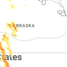
Nebraska
| Local Time | Report Details |
|---|---|
| 3:15 PM CDT | Hen Egg sized hail reported near Merna, NE, 45.4 miles ENE of North Platte, NE |
| 3:22 PM CDT | Quarter sized hail reported near Stapleton, NE, 33.2 miles NE of North Platte, NE, caller reports holes punched in outbuilding roof. time estimated from radar. |
| 3:40 PM CDT | Time estimated by rada in custer county NE, 47 miles ENE of North Platte, NE |
| 3:57 PM CDT | Hen Egg sized hail reported near Arnold, NE, 35.3 miles ENE of North Platte, NE, reports of vehicle damage in parking lot of business. time estimated from radar. |
| 4:00 PM CDT | Golf Ball sized hail reported near Oconto, NE, 47.4 miles E of North Platte, NE |
| 5:30 PM CDT | Quarter sized hail reported near North Platte, NE, 10.1 miles S of North Platte, NE |
| 6:30 PM CDT | Quarter sized hail reported near Curtis, NE, 37.4 miles SSE of North Platte, NE |
| 6:49 PM CDT | Measured on personal weather statio in frontier county NE, 31.7 miles S of North Platte, NE |
| 6:58 PM CDT | Storm damage reported in frontier county NE, 48.3 miles SSE of North Platte, NE |
| 7:02 PM CDT | Golf Ball sized hail reported near Hayes Center, NE, 43.3 miles SSW of North Platte, NE |
| 7:36 PM CDT | Mesonet station reports 61 mph gust at locatio in hitchcock county NE, 54.8 miles N of Colby, KS |
| 7:42 PM CDT | Asos station kmck mccook airpor in red willow county NE, 60.7 miles NNE of Colby, KS |
Pennsylvania
| Local Time | Report Details |
|---|---|
| 4:38 PM EDT | Quarter sized hail reported near Plymouth Meeting, PA, 78.3 miles WSW of Brooklyn, NY, report from mping: quarter (1.00 in.). |
| 4:45 PM EDT | Trees down across jacksonville road blocking the roadway. time estimated by rada in centre county PA, 11 miles NNE of State College, PA |
| 5:24 PM EDT | Lycoming 911 reports trees and wires down across the 300 block of klump r in lycoming county PA, 57.8 miles NE of State College, PA |
| 5:40 PM EDT | Tree down on n abington road time estimated from rada in lackawanna county PA, 8.2 miles NNW of Scranton, PA |
| 5:45 PM EDT | Tree down in road time estimated from rada in lackawanna county PA, 9.1 miles N of Scranton, PA |
| 6:10 PM EDT | Trees down time estimated from rada in susquehanna county PA, 31.9 miles NNW of Scranton, PA |
| 6:17 PM EDT | Multiple reports of trees down in bridgewater township. time estimated from rada in susquehanna county PA, 32 miles NNW of Scranton, PA |
| 6:17 PM EDT | Trees down on summit street. time estimated from rada in susquehanna county PA, 32.6 miles N of Scranton, PA |
| 6:22 PM EDT | Multiple reports of trees down in franklin township. time estimated from rada in susquehanna county PA, 34.3 miles NNW of Scranton, PA |
| 6:26 PM EDT | Multiple reports of trees and wires down in overfield township. time estimated from rada in wyoming county PA, 10.8 miles NW of Scranton, PA |
| 6:26 PM EDT | Multiple reports of trees and wires down in falls township. time estimated from rada in wyoming county PA, 10 miles WNW of Scranton, PA |
| 6:35 PM EDT | Multiple reports of trees down in liberty township. time estimated from rada in susquehanna county PA, 39.6 miles NNW of Scranton, PA |
Delaware
| Local Time | Report Details |
|---|---|
| 4:47 PM EDT | Wires down resulting in power outages. time estimated via rada in kent county DE, 47 miles NNW of Ocean City, MD |
Texas
| Local Time | Report Details |
|---|---|
| 4:28 PM CDT | Quarter sized hail reported near De Leon, TX, 74.3 miles ESE of Abilene, TX, public call reports hail ranging from peas to quarters. time estimated by caller. |
| 4:52 PM CDT | Power poles down on circle drive in lake colema in coleman county TX, 31 miles SSE of Abilene, TX |
| 4:52 PM CDT | Power poles dow in coleman county TX, 32.4 miles SSE of Abilene, TX |
| 5:15 PM CDT | 50 kt wind measured by the awos at comanche county-city airpor in comanche county TX, 75.6 miles NW of Killeen, TX |
| 9:08 PM CDT | Bird... tx raws sit in gillespie county TX, 58.1 miles N of San Antonio, TX |
| 10:25 PM CDT | Measured by the west texas mesone in parmer county TX, 61.9 miles SW of Amarillo, TX |
Kansas
| Local Time | Report Details |
|---|---|
| 5:27 PM CDT | Quarter sized hail reported near Saint Francis, KS, 43.5 miles ESE of Yuma, CO, quarter sized hail reported at location. |
| 6:28 PM CDT | Ping Pong Ball sized hail reported near Saint Francis, KS, 43.4 miles NW of Colby, KS, report received via social media of ping pong ball sized hail at location. |
| 6:29 PM CDT | Hen Egg sized hail reported near Saint Francis, KS, 43.4 miles NW of Colby, KS, 2 inch diameter hail reported at location via social media. |
| 6:42 PM CDT | Golf Ball sized hail reported near Saint Francis, KS, 41.9 miles WNW of Colby, KS, estimated golf ball sized hail reported at location via social media. |
| 9:24 PM CDT | Storm damage reported in sheridan county KS, 25.9 miles ENE of Colby, KS |
| 9:45 PM CDT | Half Dollar sized hail reported near Hoxie, KS, 32.6 miles E of Colby, KS, report received via social media of half dollar sized hail at location. possibly larger size as hail was not collected and measured immediately. |
| 9:45 PM CDT | Quarter sized hail reported near Hoxie, KS, 32.5 miles E of Colby, KS, corrects previous hail report from hoxie. report received via social media of hail up to quarters in size at location. |
| 9:53 PM CDT | Mesonet site at location reported a 62 mph thunderstorm wind gus in sheridan county KS, 35.8 miles ESE of Colby, KS |
| 10:00 PM CDT | Mesonet station at location reported a 59 mph thunderstorm wind gus in sheridan county KS, 33.9 miles ESE of Colby, KS |
| 10:01 PM CDT | Storm damage reported in sheridan county KS, 33.9 miles ESE of Colby, KS |
| 10:15 PM CDT | Kshp reported 3 semis rolling over due to strong winds between mm99 and mm104 on i-7 in gove county KS, 42.1 miles ESE of Colby, KS |
| 10:19 PM CDT | Mesonet station reported a 72 mph wind gust at locatio in gove county KS, 44.4 miles ESE of Colby, KS |
| 10:20 PM CDT | Corrects previous tstm wnd gst report from 3 ese park. mesonet station reported a 62 mph wind gust at locatio in gove county KS, 44.4 miles ESE of Colby, KS |
| 10:26 PM CDT | Storm damage reported in gove county KS, 48.7 miles ESE of Colby, KS |
| 10:33 PM CDT | Mesonet station ovek1 gove 5s in gove county KS, 47.8 miles SE of Colby, KS |
| 10:47 PM CDT | Storm damage reported in gove county KS, 53.5 miles W of Hays, KS |
| 12:57 AM CDT | Kansas mesonet site at 10 in wichita county KS, 43.1 miles NW of Garden City, KS |
| 1:59 AM CDT | Broadcast media relay of a measured wind gust report at main st. and santa fe st. in south garden cit in finney county KS, 0.7 miles SSE of Garden City, KS |
New York
| Local Time | Report Details |
|---|---|
| 6:30 PM EDT | Single tree down near the shawagunk mountain area. time estimated from radar in ulster county NY, 72.3 miles N of Brooklyn, NY |
| 6:34 PM EDT | Tree and wires down between wawarsing and napanoch. time estimated from rada in ulster county NY, 73.1 miles ENE of Scranton, PA |
Oklahoma
| Local Time | Report Details |
|---|---|
| 5:54 PM CDT | Tennis Ball sized hail reported near Boise City, OK, 116 miles SW of Garden City, KS, report passed along by emergency manager with photos of hail. |
| 7:07 PM CDT | Quarter sized hail reported near Boise City, OK, 119.4 miles SW of Garden City, KS |
Tennessee
| Local Time | Report Details |
|---|---|
| 7:12 PM EDT | Trees down in the pinecrest communit in campbell county TN, 30 miles NNW of Knoxville, TN |
| 8:05 PM EDT | Few trees down near arthur. time estimated from rada in claiborne county TN, 40.7 miles NNE of Knoxville, TN |
New Mexico
| Local Time | Report Details |
|---|---|
| 6:35 PM MDT | Corrects previous high sust winds report from 7 e tucumcari. asos station ktcc tucumcari muni airpor in quay county NM, 7.1 miles E of Tucumcari, NM |
| 6:37 PM MDT | Mesonet station remn5 bitter lake wl refuge 14 nne (eight mile draw in chaves county NM, 21.1 miles NNE of Roswell, NM |
| 6:55 PM MDT | Asos station krow roswell air cente in chaves county NM, 6.7 miles SSE of Roswell, NM |
Wyoming
| Local Time | Report Details |
|---|---|
| 7:30 PM MDT | Quarter sized hail reported near Glendo, WY, 62.4 miles ESE of Casper, WY, platte/converse county line wydot sensor and webcam. hail covering interstate 25. observation had zero visibility with heavy rain and wind gusts to 51 mph. |
| 8:58 PM MDT | Golf Ball sized hail reported near Fort Laramie, WY, 52.3 miles WNW of Scottsbluff, NE |
| 8:58 PM MDT | Ping Pong Ball sized hail reported near Douglas, WY, 48.4 miles E of Casper, WY, report from mping: ping pong ball (1.50 in.). |
| 9:00 PM MDT | Golf Ball sized hail reported near Douglas, WY, 47.7 miles E of Casper, WY, golfball to baseball sized hail. |
| 9:19 PM MDT | Hen Egg sized hail reported near Fort Laramie, WY, 50.9 miles WNW of Scottsbluff, NE, spotter reported 2 inch hail ongoing. started at 911pm. |
| 9:25 PM MDT | Half Dollar sized hail reported near Douglas, WY, 44.4 miles E of Casper, WY, report from mping: half dollar (1.25 in.). |
| 9:26 PM MDT | Golf Ball sized hail reported near Fort Laramie, WY, 46.9 miles WNW of Scottsbluff, NE, golf ball hail at mile marker 34 on highway 26 between fort laramie and lingle. |
| 9:35 PM MDT | Ping Pong Ball sized hail reported near Lingle, WY, 41.2 miles WNW of Scottsbluff, NE, all large hail. very little rainfall. |
| 9:45 PM MDT | Baseball sized hail reported near Lingle, WY, 45.5 miles WNW of Scottsbluff, NE, emergency manager reported 2.8 inch hail relayed from dan fitts. |
| 10:43 PM MDT | Quarter sized hail reported near Guernsey, WY, 65.8 miles WNW of Scottsbluff, NE, spotter found 1" hail on the ground accumulated several inches deep at 10:56pm. estimated time hail fell based on radar. |
| 11:46 PM MDT | Golf Ball sized hail reported near Veteran, WY, 37.8 miles WNW of Scottsbluff, NE, roads covered in hail accumulation. largest hailstone was golf ball sized. |
| 12:00 AM MDT | Quarter sized hail reported near Yoder, WY, 32.6 miles W of Scottsbluff, NE |
| 12:06 AM MDT | Ping Pong Ball sized hail reported near Yoder, WY, 32 miles W of Scottsbluff, NE, hail accumulating to several inches deep. |
Connecticut
| Local Time | Report Details |
|---|---|
| 10:09 PM EDT | Two power lines down in the road on old roberts stree in hartford county CT, 62 miles W of Providence, RI |
South Dakota
| Local Time | Report Details |
|---|---|
| 10:01 PM MDT | Storm damage reported in custer county SD, 29.1 miles SSE of Rapid City, SD |
Connect with Interactive Hail Maps