

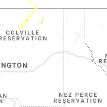
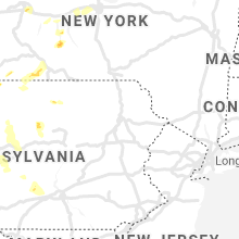
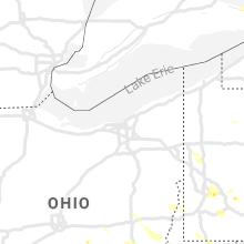
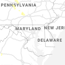
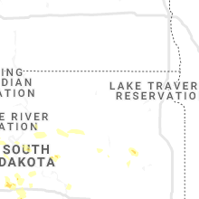
Hail Map for Sunday, June 13, 2021

Number of Impacted Households on 6/13/2021
0
Impacted by 1" or Larger Hail
0
Impacted by 1.75" or Larger Hail
0
Impacted by 2.5" or Larger Hail
Square Miles of Populated Area Impacted on 6/13/2021
0
Impacted by 1" or Larger Hail
0
Impacted by 1.75" or Larger Hail
0
Impacted by 2.5" or Larger Hail


Cities Most Affected by Hail Storms of 6/13/2021
| Hail Size | Demographics of Zip Codes Affected | ||||||
|---|---|---|---|---|---|---|---|
| City | Count | Average | Largest | Pop Density | House Value | Income | Age |
| Aurora, CO | 1 | 1.75 | 1.75 | 2016 | $132k | $39.1k | 30.8 |
| Sheffield, PA | 1 | 1.75 | 1.75 | 7 | $47k | $34.9k | 46.8 |
| Morrill, NE | 1 | 1.75 | 1.75 | 8 | $55k | $31.2k | 42.7 |
| Carpenter, WY | 1 | 1.75 | 1.75 | 4 | $103k | $33.8k | 39.2 |
| Hillsdale, WY | 1 | 1.75 | 1.75 | 0 | $225k | $42.1k | 38.1 |
| Kilgore, NE | 1 | 1.75 | 1.75 | 0 | $30k | $28.9k | 44.8 |
| Lingle, WY | 1 | 1.75 | 1.75 | 3 | $78k | $36.6k | 46.5 |
Hail and Wind Damage Spotted on 6/13/2021
Filter by Report Type:Hail ReportsWind Reports
States Impacted
Pennsylvania, West Virginia, Maryland, Oklahoma, Virginia, Ohio, Florida, South Dakota, Alabama, Kentucky, Mississippi, Louisiana, Colorado, Wyoming, Nebraska, Wisconsin, Michigan, New York, Montana, North Carolina, TexasPennsylvania
| Local Time | Report Details |
|---|---|
| 9:30 AM EDT | Trees down on powerlines near myers s in somerset county PA, 60.1 miles ESE of Pittsburgh, PA |
| 3:48 PM EDT | Quarter sized hail reported near Blossburg, PA, 73.7 miles NNE of State College, PA, five minutes of quarter-size hail in blossburg. |
| 4:15 PM EDT | Report of multiple downed trees in new castl in lawrence county PA, 43 miles NNW of Pittsburgh, PA |
| 4:17 PM EDT | Report of wind knocking down multiple power lines southeast of new castl in lawrence county PA, 41 miles NNW of Pittsburgh, PA |
| 4:20 PM EDT | Large tree snapped in half and on road in neshannock township. time estimated based on rada in lawrence county PA, 44.8 miles NNW of Pittsburgh, PA |
| 4:23 PM EDT | Quarter sized hail reported near New Castle, PA, 41.9 miles NNW of Pittsburgh, PA, nickel to quarter size hail. time estimated based on radar. |
| 4:27 PM EDT | Power lines down with estimated 60 mph wind in lawrence county PA, 39.8 miles NNW of Pittsburgh, PA |
| 4:40 PM EDT | Trees down on wires in watervill in lycoming county PA, 44.2 miles NE of State College, PA |
| 5:25 PM EDT | Trees down across mallard lan in clinton county PA, 40.7 miles NE of State College, PA |
| 5:28 PM EDT | Trees down on wires in avi in clinton county PA, 39.2 miles NE of State College, PA |
| 5:34 PM EDT | Pictures showing uprooted trees and blown apart swing sets in mars. time estimated based on rada in butler county PA, 18.1 miles N of Pittsburgh, PA |
| 5:35 PM EDT | Numerous large trees snapped near pa turnpik in allegheny county PA, 13.9 miles N of Pittsburgh, PA |
| 5:48 PM EDT | Report of large tree limbs dow in allegheny county PA, 13.5 miles NNW of Pittsburgh, PA |
| 5:55 PM EDT | Report of multiple trees dow in allegheny county PA, 6 miles NNE of Pittsburgh, PA |
| 5:55 PM EDT | Quarter sized hail reported near Allison Park, PA, 11.2 miles N of Pittsburgh, PA |
| 5:58 PM EDT | Large tree limbs down as wel in allegheny county PA, 6.4 miles N of Pittsburgh, PA |
| 5:58 PM EDT | Quarter sized hail reported near Pittsburgh, PA, 6.4 miles N of Pittsburgh, PA, large tree limbs down as well. |
| 5:59 PM EDT | Quarter sized hail reported near Wexford, PA, 13.5 miles NNW of Pittsburgh, PA, hail fell steadily for 5 minutes. |
| 6:00 PM EDT | Trees reported downed around the are in allegheny county PA, 9.9 miles N of Pittsburgh, PA |
| 6:00 PM EDT | A few trees and numerous large branches dow in allegheny county PA, 3.2 miles NNE of Pittsburgh, PA |
| 6:00 PM EDT | Report of large tree limb down on grandview aven in mount washingto in allegheny county PA, 0.9 miles SW of Pittsburgh, PA |
| 6:10 PM EDT | Large tree limb snapped off near pittsburgh fire bureau station in allegheny county PA, 2.9 miles NE of Pittsburgh, PA |
| 6:10 PM EDT | Numerous reports of damage to structures within the cit in allegheny county PA, 0.9 miles E of Pittsburgh, PA |
| 6:11 PM EDT | Large tree uprooted along mintwood stree in allegheny county PA, 2.5 miles NE of Pittsburgh, PA |
| 6:15 PM EDT | Quarter sized hail reported near Pittsburgh, PA, 4.1 miles E of Pittsburgh, PA |
| 6:15 PM EDT | Quarter sized hail reported near Pittsburgh, PA, 3.6 miles E of Pittsburgh, PA |
| 6:15 PM EDT | Picture of tree onto house plus report of additional large branches dow in allegheny county PA, 3.6 miles E of Pittsburgh, PA |
| 6:24 PM EDT | Half Dollar sized hail reported near Pittsburgh, PA, 4.4 miles ENE of Pittsburgh, PA |
| 6:25 PM EDT | Trees reported down and small hai in allegheny county PA, 6 miles NNE of Pittsburgh, PA |
| 6:30 PM EDT | Report of multiple trees down. time estimated based on rada in allegheny county PA, 2.9 miles NE of Pittsburgh, PA |
| 6:52 PM EDT | Trees down on wire in clinton county PA, 30.3 miles N of State College, PA |
| 7:10 PM EDT | Golf Ball sized hail reported near Sheffield, PA, 81.6 miles S of Buffalo, NY, golf ball size hail in sheffield. |
| 7:12 PM EDT | Quarter sized hail reported near Sheffield, PA, 82.2 miles S of Buffalo, NY, quarter-size hail in sheffield. |
| 7:24 PM EDT | Tree down across walnut roa in centre county PA, 18 miles N of State College, PA |
| 7:45 PM EDT | Interstate 79 down to one lane due to flash flood waters submerging one lan in washington county PA, 11.5 miles SW of Pittsburgh, PA |
| 8:02 PM EDT | Trees down on wires on south mountain roa in centre county PA, 13.6 miles W of State College, PA |
| 8:04 PM EDT | Quarter sized hail reported near Bradford, PA, 72.7 miles S of Buffalo, NY |
West Virginia
| Local Time | Report Details |
|---|---|
| 12:15 PM EDT | A tree blew down on patterson creek road near medle in grant county WV, 47 miles ENE of Elkins, WV |
| 12:24 PM EDT | Five trees blew down in the old fields are in hardy county WV, 50.4 miles ENE of Elkins, WV |
| 12:30 PM EDT | A tree blew down on fort run road near old west virginia 5 in hardy county WV, 53.7 miles ENE of Elkins, WV |
| 12:34 PM EDT | Tree blew down on garrett highway (route 219) near gnegy church roa in garrett county MD, 31.1 miles NE of Elkins, WV |
| 12:55 PM EDT | A tree blew down on wv-90 henry dobbin highway about 1 mile in from the county lin in grant county WV, 28.9 miles NE of Elkins, WV |
| 1:08 PM EDT | Tree down along glen falls road in harrison county WV, 35.8 miles NW of Elkins, WV |
| 1:15 PM EDT | Tree down along buffalo calf road in harrison county WV, 46.1 miles WNW of Elkins, WV |
| 1:30 PM EDT | Multiple trees reported down around the tow in preston county WV, 38.7 miles NNE of Elkins, WV |
| 1:30 PM EDT | Multiple trees reported down across the tow in preston county WV, 30.7 miles NNE of Elkins, WV |
| 1:35 PM EDT | Numerous trees reported down across the tow in preston county WV, 32.5 miles N of Elkins, WV |
| 2:07 PM EDT | Report of tree down on interstate 79 at mile marked 150. time estimated based on rada in monongalia county WV, 46.5 miles N of Elkins, WV |
| 2:25 PM EDT | Tree down along hickory flat r in upshur county WV, 20.3 miles W of Elkins, WV |
| 2:25 PM EDT | Tree down along lick run rd. time estimated from rada in upshur county WV, 23.1 miles W of Elkins, WV |
| 3:30 PM EDT | Tree down along brushy fork road in buckhannon in upshur county WV, 21.3 miles WNW of Elkins, WV |
| 3:40 PM EDT | Tree down along gregorys run road. time corrected from previous report in harrison county WV, 40.9 miles NW of Elkins, WV |
| 3:52 PM EDT | Tree down at us-50 and borland springs rd... time estimated from radar in wood county WV, 65.5 miles NNE of Charleston, WV |
| 4:05 PM EDT | Tree down along hastings run road. time estimated from radar in harrison county WV, 34 miles NW of Elkins, WV |
| 5:36 PM EDT | One tree down in buffalo. time estimated from radar in putnam county WV, 25.7 miles NW of Charleston, WV |
| 5:52 PM EDT | Pictures on twitter indicate damage to the roof of a barn... as well as several large trees down in wood county WV, 49.3 miles N of Charleston, WV |
| 5:57 PM EDT | Quarter sized hail reported near Chloe, WV, 37.9 miles NE of Charleston, WV |
| 6:08 PM EDT | Tree down along aarons fork road in sissonville in kanawha county WV, 7.8 miles NNW of Charleston, WV |
| 6:24 PM EDT | Power lines blown down onto the roadway at the 3100 block of greenbrier street in kanawha county WV, 5.2 miles WSW of Charleston, WV |
| 6:30 PM EDT | Several large trees down. pictures posted to social media in braxton county WV, 47.4 miles ENE of Charleston, WV |
| 6:44 PM EDT | Multiple trees down in the town of cowe in webster county WV, 52.5 miles SW of Elkins, WV |
| 6:54 PM EDT | 3 trees reported down in mount nebo. time estimated from rada in nicholas county WV, 44.1 miles ESE of Charleston, WV |
| 7:04 PM EDT | Tree down along gregorys run road in harrison county WV, 40.9 miles NW of Elkins, WV |
| 7:07 PM EDT | Several trees reported down along route 3 in boone county WV, 16.8 miles S of Charleston, WV |
| 7:07 PM EDT | Two trees reported down in richwood. time estimated from rada in nicholas county WV, 60.4 miles E of Charleston, WV |
| 7:13 PM EDT | Several trees down... time estimated from radar in fayette county WV, 33.7 miles ESE of Charleston, WV |
| 7:19 PM EDT | Tree down along jesses run road in lewis county WV, 33 miles WNW of Elkins, WV |
| 7:20 PM EDT | Anjean road still closed due to downed tree in greenbrier county WV, 58.4 miles ESE of Charleston, WV |
| 7:23 PM EDT | Multiple trees and power lines down countywid in greenbrier county WV, 59.1 miles ESE of Charleston, WV |
| 7:24 PM EDT | Tree down along stone road and overbrook road in kanawha county WV, 2.8 miles SSW of Charleston, WV |
| 7:27 PM EDT | Several trees down in fayette county WV, 45.2 miles ESE of Charleston, WV |
| 7:30 PM EDT | Tree down in east bank in kanawha county WV, 14.9 miles SE of Charleston, WV |
| 7:45 PM EDT | Several trees down. time estimated from radar in raleigh county WV, 34.6 miles SSE of Charleston, WV |
| 7:50 PM EDT | Fallen live power line set downed tree across road on fir in greenbrier county WV, 44 miles NW of Roanoke, VA |
| 7:51 PM EDT | Teaberry road still closed due to down tree in greenbrier county WV, 43.3 miles NW of Roanoke, VA |
| 7:51 PM EDT | One tree down on moore roa in greenbrier county WV, 43.4 miles NW of Roanoke, VA |
| 7:59 PM EDT | Multiple trees down around the hillsdale area of monroe count in monroe county WV, 38.6 miles NW of Roanoke, VA |
| 8:17 PM EDT | One tree down on bozoo roa in monroe county WV, 50.1 miles WNW of Roanoke, VA |
| 8:25 PM EDT | Tree down and onto a house on morris ave. time estimated from radar in raleigh county WV, 48.1 miles SSE of Charleston, WV |
Maryland
| Local Time | Report Details |
|---|---|
| 12:40 PM EDT | A tree blew down on md-79 petersville road near chick lan in frederick county MD, 54.2 miles W of Baltimore, MD |
Oklahoma
| Local Time | Report Details |
|---|---|
| 11:45 AM CDT | Large trees downed. est. 60 to 65 mp in greer county OK, 50.6 miles NE of Childress, TX |
| 2:56 PM CDT | Telephone lines are inoperable from storms earlier in the da in greer county OK, 51 miles NE of Childress, TX |
| 8:25 PM CDT | Powerlines downed. time roughly estimated by rada in stephens county OK, 40.1 miles NE of Wichita Falls, TX |
Virginia
| Local Time | Report Details |
|---|---|
| 1:36 PM EDT | Tree blew down on river road near new market depot roa in shenandoah county VA, 64.6 miles ESE of Elkins, WV |
| 1:39 PM EDT | Tree blew down on va617 river road near va-728 new market depot roa in shenandoah county VA, 64.6 miles ESE of Elkins, WV |
| 1:42 PM EDT | Tree and wires down on turleytown road just south of the village of turleytow in rockingham county VA, 56.9 miles ESE of Elkins, WV |
| 1:55 PM EDT | Tree... pole... and wires blew down in the 5000 block of mill creek roa in page county VA, 75.5 miles ESE of Elkins, WV |
| 1:57 PM EDT | Three trees blew down on boston road near cb lan in page county VA, 73.9 miles ESE of Elkins, WV |
| 1:59 PM EDT | Tree blew down on honeyville road near park roa in page county VA, 76.1 miles ESE of Elkins, WV |
| 1:59 PM EDT | Three trees blew down on boston road near cb lan in page county VA, 73.9 miles ESE of Elkins, WV |
| 2:00 PM EDT | A tree... pole... and wires blew down in the 5000 block of mill creek road. tree blew down on honeyville road near park roa in page county VA, 75.5 miles ESE of Elkins, WV |
| 2:30 PM EDT | Several 3 inch diameter branches broken off near the intersection of middle ridge road and little gap roa in rockingham county VA, 75.1 miles ESE of Elkins, WV |
| 3:22 PM EDT | A few trees and wires blew down near mount solo in augusta county VA, 55.6 miles SE of Elkins, WV |
| 3:49 PM EDT | Three trees blew onto apartment buildings on frontier ridge court. trees and branches also blew down onto cars. multiple other trees... wires... and poles down in the a in augusta county VA, 69.7 miles SE of Elkins, WV |
| 3:50 PM EDT | Multiple trees blew down near the city of staunto in augusta county VA, 70 miles SE of Elkins, WV |
| 3:54 PM EDT | Several three inch diameter branches broken off trees in the 3000 block of barterbrook roa in augusta county VA, 69.3 miles SE of Elkins, WV |
| 4:05 PM EDT | A few trees and wires blew down in the stuarts draft are in augusta county VA, 75.6 miles NE of Roanoke, VA |
| 5:40 PM EDT | Trees uprooted near intersection of straub lane and valley pike roa in rockbridge county VA, 47.2 miles NE of Roanoke, VA |
| 5:40 PM EDT | Metal roof torn off shed off cedar hill lan in rockbridge county VA, 48.1 miles NE of Roanoke, VA |
| 5:41 PM EDT | Trees snapped near virginia horse cente in rockbridge county VA, 46.3 miles NE of Roanoke, VA |
| 6:00 PM EDT | Multiple reports of trees and powerlines down countywid in city of lexington county VA, 44.9 miles NE of Roanoke, VA |
| 6:09 PM EDT | More than 20 trees down along stuartsburg road in buena vist in rockbridge county VA, 45.5 miles NE of Roanoke, VA |
| 6:45 PM EDT | One tree down on power lines along thrasher roa in botetourt county VA, 22.1 miles NNE of Roanoke, VA |
| 6:55 PM EDT | Several trees dow in bedford county VA, 36.4 miles ENE of Roanoke, VA |
| 7:25 PM EDT | Tree dow in bedford county VA, 31.1 miles ENE of Roanoke, VA |
| 7:30 PM EDT | Tree down along cottontown r in bedford county VA, 36.4 miles ENE of Roanoke, VA |
| 7:49 PM EDT | One tree down on 13th street n in city of roanoke county VA, 1.7 miles NE of Roanoke, VA |
| 7:51 PM EDT | Trees and powerlines down across roanoke cit in city of roanoke county VA, 0.1 miles SSE of Roanoke, VA |
| 8:00 PM EDT | Tree dow in bedford county VA, 16.7 miles ESE of Roanoke, VA |
| 8:03 PM EDT | Quarter sized hail reported near Roanoke, VA, 3.6 miles S of Roanoke, VA |
| 8:07 PM EDT | Quarter sized hail reported near Roanoke, VA, 2.7 miles SE of Roanoke, VA |
| 8:20 PM EDT | Tree down blocking roadway at boones mill road and terrace roa in franklin county VA, 10.4 miles S of Roanoke, VA |
| 8:23 PM EDT | Tree down on powerline in franklin county VA, 12 miles S of Roanoke, VA |
| 8:42 PM EDT | Multiple trees down along glade roa in montgomery county VA, 28.7 miles W of Roanoke, VA |
| 8:44 PM EDT | One tree down on bonbrook roa in franklin county VA, 13.1 miles SSE of Roanoke, VA |
| 8:47 PM EDT | One tree down on chestnut hill road blocking the roadwa in franklin county VA, 19.2 miles SSE of Roanoke, VA |
| 8:53 PM EDT | Tree down in cambria area of christiansbur in montgomery county VA, 27.4 miles WSW of Roanoke, VA |
| 9:03 PM EDT | Tree down across river ridge roa in floyd county VA, 23.8 miles SSW of Roanoke, VA |
| 9:10 PM EDT | One tree down across ridgeview roa in floyd county VA, 32.9 miles SW of Roanoke, VA |
| 9:19 PM EDT | Two trees down on barberry roa in floyd county VA, 32.2 miles SW of Roanoke, VA |
| 9:20 PM EDT | Tree and powerlines down in the town of floy in floyd county VA, 32.6 miles SW of Roanoke, VA |
| 9:50 PM EDT | One tree down on daniels creek roa in henry county VA, 38.7 miles S of Roanoke, VA |
| 9:52 PM EDT | One tree down on ferndale driv in henry county VA, 37.4 miles S of Roanoke, VA |
Ohio
| Local Time | Report Details |
|---|---|
| 1:36 PM EDT | Quarter sized hail reported near Barnesville, OH, 74.7 miles WSW of Pittsburgh, PA, nickel to quarter size hail with heavy winds. |
| 1:50 PM EDT | Quarter sized hail reported near Jerusalem, OH, 73.8 miles WSW of Pittsburgh, PA, nickel to quarter size hail. location estimatd based on radar. |
| 2:59 PM EDT | State patrol reporting 4 power poles downed along sr 209 near mile marker in guernsey county OH, 75.1 miles E of Columbus, OH |
| 3:15 PM EDT | Several trees and power lines down in the village of waverly. time estimated from rada in pike county OH, 57.4 miles S of Columbus, OH |
| 3:17 PM EDT | Trees down on meadow run road. time estimated from rada in pike county OH, 60.3 miles S of Columbus, OH |
| 3:40 PM EDT | 2.75 inch diameter branches broken from multiple trees in jackson county OH, 65.2 miles SSE of Columbus, OH |
| 3:51 PM EDT | Trees down in lucasville. time estimated from rada in scioto county OH, 74.6 miles S of Columbus, OH |
| 3:55 PM EDT | Trees down. time estimated from rada in scioto county OH, 72.6 miles ESE of Cincinnati, OH |
| 3:55 PM EDT | Tree down on bethel ridge rd... time estimated from radar in jackson county OH, 62.8 miles SSE of Columbus, OH |
| 3:59 PM EDT | Trees down. time estimated from rada in scioto county OH, 74.9 miles WNW of Charleston, WV |
| 4:36 PM EDT | Several trees reported down along sr 26 between mile markers 6 to 17 in washington county OH, 75.7 miles NNE of Charleston, WV |
Florida
| Local Time | Report Details |
|---|---|
| 1:53 PM EDT | A tree down blocking cr 335 near ne 160th av in levy county FL, 80.4 miles SW of Jacksonville, FL |
| 2:10 PM EDT | Usaf wind tower 403 measured a peak wind gust of 52kt/60mph from the wn in brevard county FL, 48.2 miles E of Orlando, FL |
| 2:35 PM EDT | Cocoa fd reported roof damage to several homes along cocoa bay blvd.... in coco in brevard county FL, 38.5 miles ESE of Orlando, FL |
| 3:36 PM EDT | Quarter sized hail reported near Bunnell, FL, 63.9 miles SSE of Jacksonville, FL, ham radio operator passed along a report from a trained spotter of quarter size hail falling at us-1 in bunnell. |
South Dakota
| Local Time | Report Details |
|---|---|
| 1:05 PM CDT | Mesonet station 212 agar (sddot in potter county SD, 39 miles NNE of Pierre, SD |
| 1:05 AM CDT | Quarter sized hail reported near Huron, SD, 70.7 miles SSE of Aberdeen, SD |
Alabama
| Local Time | Report Details |
|---|---|
| 1:26 PM CDT | Trees and powerlines down. trees were also reported down in the city of fayette... and near berry and newtonvill in fayette county AL, 52.1 miles W of Birmingham, AL |
| 1:35 PM CDT | Trees and power lines down near eldridg in walker county AL, 53.8 miles WNW of Birmingham, AL |
| 1:37 PM CDT | Trees and powerlines dow in fayette county AL, 50.3 miles WNW of Birmingham, AL |
| 2:08 PM CDT | Trees and powerlines down. report relayed through social medi in walker county AL, 45.1 miles NW of Birmingham, AL |
| 2:09 PM CDT | Corrects previous tstm wnd dmg report from 3 s lupton. numerous trees and powerlines down in saragoss in walker county AL, 42.8 miles NW of Birmingham, AL |
Kentucky
| Local Time | Report Details |
|---|---|
| 2:50 PM EDT | Tree down in the morgan manor neighborhood in georgetown... ky at approximately 2:50p in scott county KY, 52.9 miles NW of Irvine, KY |
| 3:05 PM EDT | Delayed report: tree down at pea ridge rd. time estimated from rada in scott county KY, 54.7 miles NW of Irvine, KY |
| 3:09 PM EDT | Delayed report: tree down across cynthiana rd. time estimated from rada in bourbon county KY, 40.2 miles NNW of Irvine, KY |
| 3:57 PM EDT | Trees down on mill creek road. time estimated from rada in mason county KY, 56.4 miles SE of Cincinnati, OH |
| 4:55 PM EDT | Two trees down in greenup county KY, 75.9 miles WNW of Charleston, WV |
| 5:00 PM EDT | Multiple trees down. times estimated from rada in lewis county KY, 76.5 miles NE of Irvine, KY |
| 5:08 PM EDT | Trees down along laurel road in greenup county KY, 71.6 miles W of Charleston, WV |
| 5:09 PM EDT | Power lines down in area of crane creek in greenup county KY, 70.8 miles W of Charleston, WV |
| 4:15 PM CDT | Delayed report: tree down on knob lick wisdom rd. time estimated from rada in metcalfe county KY, 64.7 miles S of Louisville, KY |
| 6:44 PM EDT | Tree blown down on route 421 nort in jackson county KY, 15.4 miles SSW of Irvine, KY |
| 6:44 PM EDT | Tree blown down on route 421 nort in knott county KY, 51.7 miles ESE of Irvine, KY |
| 7:03 PM EDT | Tree blown down on kelly roa in jackson county KY, 20.4 miles SSE of Irvine, KY |
| 7:18 PM EDT | Tree blown dow in laurel county KY, 31.8 miles S of Irvine, KY |
| 7:30 PM EDT | Multiple trees blown down... taking power lines alon in laurel county KY, 37.1 miles S of Irvine, KY |
| 7:45 PM EDT | Numerous trees blown down in the city of london... taking along power line in laurel county KY, 39.7 miles S of Irvine, KY |
| 7:57 PM EDT | Storm damage reported in laurel county KY, 42.4 miles S of Irvine, KY |
| 8:06 PM EDT | Multiple trees blown down on ward cemetery roa in laurel county KY, 44.7 miles S of Irvine, KY |
| 8:13 PM EDT | Tree blown down along south us highway 2 in laurel county KY, 49.3 miles S of Irvine, KY |
| 8:31 PM EDT | Tree blown down on a house along corinth cemetery roa in whitley county KY, 56 miles S of Irvine, KY |
| 8:31 PM EDT | Tree blown down on high top roa in whitley county KY, 56.2 miles S of Irvine, KY |
Mississippi
| Local Time | Report Details |
|---|---|
| 2:30 PM CDT | Tree down on tabernacle r in lowndes county MS, 27.6 miles E of Starkville, MS |
| 2:48 PM CDT | Mobile homes damaged... double wide with roof blown of in kemper county MS, 53 miles S of Starkville, MS |
| 2:54 PM CDT | Trees down on hwy 493 near libert in kemper county MS, 56.3 miles S of Starkville, MS |
| 2:59 PM CDT | Multiple reports of downed trees and broken tree limbs... power outages... and minor structural damage(mainly lawn furniture) around pass christian near 90th and terrac in harrison county MS, 55.3 miles ENE of New Orleans, LA |
| 3:09 PM CDT | Several trees and power lines downed in the collinsville are in lauderdale county MS, 66.6 miles S of Starkville, MS |
| 3:24 PM CDT | Roof blown off house on gum log r in lauderdale county MS, 66.7 miles S of Starkville, MS |
| 3:28 PM CDT | Storm damage reported in lauderdale county MS, 78.4 miles S of Starkville, MS |
| 3:29 PM CDT | Tree downed on a power line along arundel r in lauderdale county MS, 78.3 miles S of Starkville, MS |
| 3:29 PM CDT | Trees downed in the house and tucker area in neshoba county MS, 56.3 miles SSW of Starkville, MS |
| 3:30 PM CDT | Tree downed on a power line on 11th av in lauderdale county MS, 71.7 miles S of Starkville, MS |
| 3:30 PM CDT | Large tree downed at 36th st near poplar springs d in lauderdale county MS, 74.4 miles S of Starkville, MS |
| 3:32 PM CDT | Trees downed in eastern neshoba c in neshoba county MS, 48.6 miles S of Starkville, MS |
| 3:38 PM CDT | Quarter sized hail reported near Meridian, MS, 80.8 miles S of Starkville, MS, public reports quarter sized hail falling in zero. |
| 3:41 PM CDT | Trees and lines down along cr 2422 in the fellowship communit in jasper county MS, 71.1 miles E of Jackson, MS |
| 3:41 PM CDT | Tree down on hwy 11 just south of hwy 51 in clarke county MS, 79.6 miles E of Jackson, MS |
| 3:44 PM CDT | Tree down blocking road at i-59 & hey 513. time estimated by rada in clarke county MS, 77.3 miles E of Jackson, MS |
| 3:44 PM CDT | Trees and power lines down along 500 block of cr513 in jasper county MS, 72.1 miles E of Jackson, MS |
| 3:47 PM CDT | Trees and power lines down along hwy 18 at cr 183 in jasper county MS, 72.6 miles E of Jackson, MS |
| 3:47 PM CDT | Tree downed in the dixon communit in neshoba county MS, 59.7 miles SSW of Starkville, MS |
| 3:50 PM CDT | Tree down on a hom in clarke county MS, 82.8 miles E of Jackson, MS |
| 4:05 PM CDT | Tree down on north jackson avenue in quitma in clarke county MS, 84 miles W of Camden, AL |
| 4:07 PM CDT | Tree down on house on leola st in stonewal in clarke county MS, 81.7 miles E of Jackson, MS |
| 4:08 PM CDT | Tree downed at ms 28 and mc meyers r in simpson county MS, 29.7 miles SSE of Jackson, MS |
| 4:19 PM CDT | Trees and power lines dow in clarke county MS, 84.7 miles E of Jackson, MS |
| 4:36 PM CDT | Tree down on kalem r in scott county MS, 34.9 miles E of Jackson, MS |
| 4:37 PM CDT | Tree downed on us 51 north of duck hil in montgomery county MS, 55.1 miles WNW of Starkville, MS |
| 4:42 PM CDT | Tree on home no injuries but entrapment on poole creek roa in jones county MS, 80.5 miles ESE of Jackson, MS |
| 4:42 PM CDT | Tree downed between winona and kilmichae in montgomery county MS, 47.8 miles W of Starkville, MS |
| 4:48 PM CDT | Tree downed in city of winon in montgomery county MS, 53 miles W of Starkville, MS |
| 5:06 PM CDT | Power lines down in northwest attala county along ms 44 in attala county MS, 57.1 miles WSW of Starkville, MS |
| 5:15 PM CDT | Tree down along attalla rd 3122 near attalla rd 2267 in berea communit in attala county MS, 39.7 miles WSW of Starkville, MS |
| 5:22 PM CDT | I-59 northbound blocked by trees at mile marker 7 in forrest county MS, 80 miles SE of Jackson, MS |
| 5:26 PM CDT | Numerous trees down in petal and in sunrise... several trees and lines down near sunrise rd and old river r in forrest county MS, 82.5 miles WNW of Mobile, AL |
| 5:31 PM CDT | Tree downed on power lines along old fannin r in rankin county MS, 9.9 miles NE of Jackson, MS |
| 5:35 PM CDT | Trees downed on ms 17 in the southern part of the count in holmes county MS, 46.4 miles NNE of Jackson, MS |
| 5:45 PM CDT | Trees downed on ward r in rankin county MS, 15.2 miles S of Jackson, MS |
| 5:45 PM CDT | Numerous trees and power lines down all over the county. over 30 individual report in forrest county MS, 72.6 miles WNW of Mobile, AL |
| 5:48 PM CDT | Tree downed on rockwood r in rankin county MS, 17.5 miles SSE of Jackson, MS |
| 6:00 PM CDT | Trees downed along us 11 north of lumberto in lamar county MS, 82.4 miles NNE of New Orleans, LA |
| 6:11 PM CDT | Multiple trees down along i-59 near mile marker 3 in pearl river county MS, 76.1 miles NNE of New Orleans, LA |
| 6:13 PM CDT | Trees downed in the way rd area... a few on house in madison county MS, 31 miles NNE of Jackson, MS |
| 6:24 PM CDT | Multiple trees down along highway 53 near savannah curv in pearl river county MS, 64.5 miles NNE of New Orleans, LA |
| 6:28 PM CDT | Several trees and utility poles downed across madison count in madison county MS, 23.2 miles NNE of Jackson, MS |
| 6:46 PM CDT | Several trees and utility poles downed across madison count in madison county MS, 15.5 miles NNE of Jackson, MS |
| 6:49 PM CDT | Trees downed in the twin harbor area... a few on house in madison county MS, 14.1 miles NNE of Jackson, MS |
Louisiana
| Local Time | Report Details |
|---|---|
| 4:20 PM CDT | Union parish sheriffs office reported a very large oak tree down on a hom in union county LA, 17.9 miles WSW of Bastrop, LA |
| 4:25 PM CDT | Quarter sized hail reported near Lacombe, LA, 25.9 miles NNE of New Orleans, LA, hail near 1 inch (some stones were slightly larger) reported in lacombe. relayed via social media. |
| 4:40 PM CDT | Quarter sized hail reported near Pearl River, LA, 41.8 miles NNE of New Orleans, LA, 1 inch hail reported along hwy 41 east of talisheek. relayed via social media. |
Colorado
| Local Time | Report Details |
|---|---|
| 4:37 PM MDT | Quarter sized hail reported near Denver, CO, 5.8 miles ESE of Denver, CO, report from mping: quarter (1.00 in.). |
| 4:41 PM MDT | Quarter sized hail reported near Aurora, CO, 8.2 miles ESE of Denver, CO |
| 4:47 PM MDT | Quarter sized hail reported near Denver, CO, 8.1 miles SE of Denver, CO |
| 4:54 PM MDT | Golf Ball sized hail reported near Aurora, CO, 9.2 miles E of Denver, CO |
| 4:55 PM MDT | Half Dollar sized hail reported near Aurora, CO, 8.2 miles ESE of Denver, CO, report from mping: half dollar (1.25 in.). |
| 5:00 PM MDT | Ping Pong Ball sized hail reported near Aurora, CO, 9.9 miles ESE of Denver, CO |
| 5:10 PM MDT | Quarter sized hail reported near Denver, CO, 7.7 miles ESE of Denver, CO |
| 5:12 PM MDT | Quarter sized hail reported near Aurora, CO, 9 miles ESE of Denver, CO, report from mping: quarter (1.00 in.). |
| 5:12 PM MDT | Ping Pong Ball sized hail reported near Aurora, CO, 8.2 miles ESE of Denver, CO |
| 5:14 PM MDT | Half Dollar sized hail reported near Aurora, CO, 12 miles SE of Denver, CO, damage to vehicles and trailers reported at cherry creek state park. minor flooding reported as well. |
| 5:16 PM MDT | Ping Pong Ball sized hail reported near Aurora, CO, 8.2 miles ESE of Denver, CO, report from mping: ping pong ball (1.50 in.). |
| 5:17 PM MDT | Half Dollar sized hail reported near Aurora, CO, 9 miles ESE of Denver, CO, report from mping: half dollar (1.25 in.). |
| 5:20 PM MDT | Ping Pong Ball sized hail reported near Aurora, CO, 9.4 miles SE of Denver, CO |
| 5:35 PM MDT | Quarter sized hail reported near Denver, CO, 4.4 miles SE of Denver, CO |
| 5:42 PM MDT | Quarter sized hail reported near Denver, CO, 4.5 miles SSE of Denver, CO, photo of several 1 inch diameter hailstones. |
| 5:43 PM MDT | Quarter sized hail reported near Denver, CO, 7 miles SSE of Denver, CO, report via spotternetwork. |
| 5:45 PM MDT | Quarter sized hail reported near Denver, CO, 6.4 miles SSE of Denver, CO |
| 5:55 PM MDT | Quarter sized hail reported near Denver, CO, 4.2 miles S of Denver, CO |
| 5:57 PM MDT | Quarter sized hail reported near Denver, CO, 4.1 miles S of Denver, CO |
| 7:10 PM MDT | Quarter sized hail reported near La Salle, CO, 44.7 miles NNE of Denver, CO |
| 7:15 PM MDT | Ping Pong Ball sized hail reported near Milliken, CO, 40.6 miles N of Denver, CO |
| 7:17 PM MDT | Half Dollar sized hail reported near Woodland Park, CO, 51.2 miles S of Denver, CO, time estimated. |
| 7:17 PM MDT | Half Dollar sized hail reported near Evans, CO, 46.1 miles NNE of Denver, CO |
| 7:17 PM MDT | Half Dollar sized hail reported near Woodland Park, CO, 49.8 miles S of Denver, CO |
| 7:20 PM MDT | Quarter sized hail reported near Woodland Park, CO, 49.7 miles S of Denver, CO, hail estimated up to quarter size. |
| 7:22 PM MDT | Half Dollar sized hail reported near Milliken, CO, 40.7 miles N of Denver, CO, estimated between quarter and golf ball sized hail falling at the time of report. |
| 7:27 PM MDT | Half Dollar sized hail reported near Milliken, CO, 41.3 miles N of Denver, CO, report via twitter. |
| 8:15 PM MDT | Awos station kfmm fort morga in morgan county CO, 58.8 miles WNW of Yuma, CO |
| 9:12 PM MDT | Mesonet station co035 076e125 sterlin in logan county CO, 41.9 miles NW of Yuma, CO |
| 9:24 PM MDT | Quarter sized hail reported near Windsor, CO, 54.3 miles N of Denver, CO |
Wyoming
| Local Time | Report Details |
|---|---|
| 4:57 PM MDT | Golf Ball sized hail reported near Lingle, WY, 42.5 miles WNW of Scottsbluff, NE |
| 5:03 PM MDT | Ping Pong Ball sized hail reported near Osage, WY, 56.2 miles ESE of Gillette, WY |
| 5:14 PM MDT | Quarter sized hail reported near Albin, WY, 43.8 miles SW of Scottsbluff, NE |
| 6:17 PM MDT | Golf Ball sized hail reported near Carpenter, WY, 63 miles ESE of Laramie, WY, report received via facebook. |
| 6:20 PM MDT | Golf Ball sized hail reported near Hillsdale, WY, 56.2 miles E of Laramie, WY |
Nebraska
| Local Time | Report Details |
|---|---|
| 5:35 PM MDT | Golf Ball sized hail reported near Morrill, NE, 14.3 miles WNW of Scottsbluff, NE |
| 6:17 PM MDT | Quarter sized hail reported near Crawford, NE, 55.2 miles NNE of Scottsbluff, NE |
| 6:20 PM MDT | Storm damage reported in scotts bluff county NE, 2.7 miles NNE of Scottsbluff, NE |
| 6:28 PM MDT | Quarter sized hail reported near Crawford, NE, 46.1 miles N of Scottsbluff, NE |
| 7:14 PM MDT | Quarter sized hail reported near Marsland, NE, 37.9 miles N of Scottsbluff, NE, report received via spotternetwork.org |
| 7:20 PM MDT | 60 mph winds reported... blew the dog houses away. pea sized hail... 0.10 rainfal in sioux county NE, 43.4 miles N of Scottsbluff, NE |
| 7:30 PM MDT | Storm damage reported in box butte county NE, 52.5 miles NE of Scottsbluff, NE |
| 8:10 PM MDT | Ping Pong Ball sized hail reported near Gordon, NE, 76.7 miles WSW of Valentine, NE, spotter reported some ping pong sized hail. |
| 9:33 PM CDT | Golf Ball sized hail reported near Kilgore, NE, 25.8 miles WNW of Valentine, NE |
Wisconsin
| Local Time | Report Details |
|---|---|
| 7:11 PM CDT | Tree down near amberg in marinette county WI, 71.7 miles N of Green Bay, WI |
| 7:50 PM CDT | Tree on a wire in marinette county WI, 39.3 miles NNE of Green Bay, WI |
| 8:15 PM CDT | Power lines down on mathey road and 3 trees down at the intersection of hwy 57 and mathey roa in door county WI, 42 miles NE of Green Bay, WI |
| 8:19 PM CDT | Couple branches down in crandon area. time estimated by radar in forest county WI, 25.4 miles ESE of Rhinelander, WI |
| 8:34 PM CDT | Tree down. time estimated by radar in forest county WI, 39.2 miles ESE of Rhinelander, WI |
| 9:05 PM CDT | Tree down in suring area. time estimated by radar in oconto county WI, 38.2 miles NNW of Green Bay, WI |
| 9:05 PM CDT | Tree down in brazeau area. time estimated by radar in oconto county WI, 41.8 miles NNW of Green Bay, WI |
| 9:46 PM CDT | Numerous reports of trees and power lines down around green bay. peak gust to 48 mph on grb asos at 946 p in brown county WI, 0.5 miles ESE of Green Bay, WI |
| 9:58 PM CDT | Couple trees down and branches on power lines on north... east and west side of appleton. time estimated by rada in outagamie county WI, 26 miles SW of Green Bay, WI |
| 10:09 PM CDT | One tree down. time estimated by radar in lincoln county WI, 11.8 miles SSW of Rhinelander, WI |
Michigan
| Local Time | Report Details |
|---|---|
| 7:30 PM CDT | Report from social media. pictures shared of downed tree branch and a flipped car port. observer said a lot of accumulating pea sized hail and extremely heavy rain. tim in menominee county MI, 68.3 miles NNE of Green Bay, WI |
New York
| Local Time | Report Details |
|---|---|
| 8:40 PM EDT | Multiple hardwood and pine trees snapped. roof off trailer and thrown into neighbor's yar in steuben county NY, 76.2 miles SW of Syracuse, NY |
| 8:51 PM EDT | Powerlines down with powerpoles snappe in schuyler county NY, 59.1 miles SW of Syracuse, NY |
| 12:38 AM EDT | Trees branches down around syracuse universit in onondaga county NY, 0.8 miles SSE of Syracuse, NY |
Montana
| Local Time | Report Details |
|---|---|
| 7:20 PM MDT | Large tree down along highway 200... 2 miles east of clearwater junctio in missoula county MT, 32 miles ENE of Missoula, MT |
| 7:30 PM MDT | Rocks and tree blocking north bound lane of highway 83... 4 miles north of highway 20 in missoula county MT, 31 miles ENE of Missoula, MT |
| 7:30 PM MDT | Large tree blocking north bound lane of highway 83... 9 miles north of highway 20 in missoula county MT, 31.4 miles ENE of Missoula, MT |
| 7:30 PM MDT | Reported 60 foot ponderosa pine fell onto shop. 2 feet in diameter. section jack fences were tipped ove in missoula county MT, 33.3 miles NE of Missoula, MT |
North Carolina
| Local Time | Report Details |
|---|---|
| 10:18 PM EDT | Thunderstorm winds blew down one tree on ward roa in stokes county NC, 56.5 miles S of Roanoke, VA |
| 10:22 PM EDT | Thunderstorm winds blew down one tree on the 1500 block of martin farm roa in stokes county NC, 57.7 miles S of Roanoke, VA |
Texas
| Local Time | Report Details |
|---|---|
| 12:24 AM CDT | Trees down near fm 968 and i-2 in harrison county TX, 44 miles W of Shreveport, LA |
| 1:25 AM CDT | Quarter sized hail reported near Gilmer, TX, 71.1 miles WNW of Shreveport, LA, quarter inch hail reported at a fast food restaurant on the north side of gilmer. |
Connect with Interactive Hail Maps