

Hail Map for Saturday, April 16, 2011

Number of Impacted Households on 4/16/2011
0
Impacted by 1" or Larger Hail
0
Impacted by 1.75" or Larger Hail
0
Impacted by 2.5" or Larger Hail
Square Miles of Populated Area Impacted on 4/16/2011
0
Impacted by 1" or Larger Hail
0
Impacted by 1.75" or Larger Hail
0
Impacted by 2.5" or Larger Hail


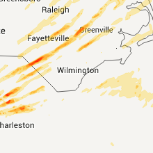


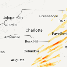
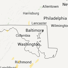


Cities Most Affected by Hail Storms of 4/16/2011
| Hail Size | Demographics of Zip Codes Affected | ||||||
|---|---|---|---|---|---|---|---|
| City | Count | Average | Largest | Pop Density | House Value | Income | Age |
| Turbeville, SC | 2 | 3.00 | 4.25 | 68 | $64k | $29.3k | 27.9 |
| Henderson, NC | 3 | 1.75 | 1.75 | 263 | $54k | $20.1k | 38.4 |
| Selma, NC | 3 | 1.75 | 1.75 | 203 | $91k | $32.9k | 35.7 |
| Snow Hill, NC | 2 | 2.25 | 2.75 | 85 | $73k | $30.7k | 38.1 |
| Alcolu, SC | 1 | 4.25 | 4.25 | 31 | $68k | $31.1k | 40.7 |
| Benson, NC | 2 | 1.88 | 2.00 | 165 | $102k | $34.8k | 37.6 |
| Pembroke, NC | 2 | 1.75 | 1.75 | 200 | $70k | $28.5k | 26.9 |
| Raleigh, NC | 2 | 1.75 | 1.75 | 1671 | $242k | $88.6k | 39.6 |
| Cross, SC | 1 | 1.75 | 1.75 | 52 | $83k | $26.9k | 43.4 |
| Fairfield, VA | 1 | 1.75 | 1.75 | 51 | $100k | $42.0k | 48.1 |
| Greeleyville, SC | 1 | 1.75 | 1.75 | 22 | $58k | $22.5k | 42.1 |
| Conway, SC | 1 | 1.75 | 1.75 | 149 | $87k | $31.4k | 37.3 |
| Orangeburg, SC | 1 | 1.75 | 1.75 | 227 | $67k | $27.4k | 33.3 |
| Roanoke Rapids, NC | 1 | 1.75 | 1.75 | 406 | $74k | $28.8k | 39.4 |
| Four Oaks, NC | 1 | 1.75 | 1.75 | 85 | $94k | $38.5k | 37.3 |
| Burlington, NC | 1 | 1.75 | 1.75 | 635 | $127k | $41.9k | 41.3 |
| Andrews, SC | 1 | 1.75 | 1.75 | 35 | $71k | $24.7k | 37.7 |
| Lake City, SC | 1 | 1.75 | 1.75 | 85 | $60k | $25.9k | 38.0 |
Hail and Wind Damage Spotted on 4/16/2011
Filter by Report Type:Hail ReportsWind Reports
States Impacted
North Carolina, Virginia, South Carolina, Ohio, West Virginia, Pennsylvania, Maryland, Delaware, New JerseyNorth Carolina
| Local Time | Report Details |
|---|---|
| 1:35 PM UTC | Possible tornado. trees down. 5 houses damaged. boats blown across road...in vicinity of 8500 block of caratoke hw in currituck county NC, 42.5 miles SSE of Virginia Beach, VA |
| 4:01 PM UTC | Tree down stopping just above and over a mobile hom in mecklenburg county NC, 13.6 miles N of Charlotte, NC |
| 4:10 PM UTC | Tree down across mallard creek road west of i-8 in mecklenburg county NC, 9.6 miles NNE of Charlotte, NC |
| 4:12 PM UTC | One tree blown down along quick roa in caswell county NC, 63.6 miles NW of Raleigh, NC |
| 4:40 PM UTC | Numerous trees down on highway 150 in rowan county NC, 35.7 miles NNE of Charlotte, NC |
| 4:45 PM UTC | Damage to houses in farrington meadows area of old mocksville roa in rowan county NC, 36.9 miles NNE of Charlotte, NC |
| 4:45 PM UTC | Trees and power lines dow in rowan county NC, 37.4 miles NNE of Charlotte, NC |
| 4:45 PM UTC | Estimates of up to 200 trees blown down in a swath along highway 601 north of salisbury. this area will be surveyed for possible tornado on sunda in rowan county NC, 39.2 miles NNE of Charlotte, NC |
| 5:00 PM UTC | Several trees and power lines down around the count in davidson county NC, 52 miles NE of Charlotte, NC |
| 5:00 PM UTC | Metal roof damage and storage buildings damaged at williams road and highway 7 in union county NC, 21.5 miles SE of Charlotte, NC |
| 5:06 PM UTC | Roof and siding damage to structures along highway 601/concord highway. trees down as wel in union county NC, 22.3 miles SE of Charlotte, NC |
| 5:24 PM UTC | 1 tree down on haire road in hoke county NC, 66.5 miles SSW of Raleigh, NC |
| 5:35 PM UTC | Tree across new home church road... multiple trees down in morven... mcfarlan... and lilesville in anson county NC, 33.8 miles ESE of Charlotte, NC |
| 5:40 PM UTC | Multiple trees down in albemarle in stanly county NC, 37.8 miles ENE of Charlotte, NC |
| 5:45 PM UTC | Siding and window damage to a church in rockingham county NC, 66.1 miles SSE of Roanoke, VA |
| 5:45 PM UTC | Tree down on power line on richardson driv in rockingham county NC, 66 miles SSE of Roanoke, VA |
| 5:45 PM UTC | Tree down at zoo parkway and newbern avenue in randolph county NC, 65.5 miles W of Raleigh, NC |
| 5:45 PM UTC | Tree down on a house at zoo parkway and newbern avenue in randolph county NC, 65.5 miles W of Raleigh, NC |
| 5:45 PM UTC | Tree down on st. andrews church road near sanford in lee county NC, 38.1 miles SW of Raleigh, NC |
| 5:50 PM UTC | Tree down on mobile home in rockingham county NC, 68.6 miles WNW of Raleigh, NC |
| 6:00 PM UTC | Numerous trees down throughout the county. time estimate in montgomery county NC, 55.2 miles ENE of Charlotte, NC |
| 6:02 PM UTC | Limbs down and strong winds observed in alamance county NC, 39.9 miles WNW of Raleigh, NC |
| 6:08 PM UTC | Trees down... roofs blown off of houses... chimneys gone in alamance county NC, 52.1 miles WNW of Raleigh, NC |
| 6:12 PM UTC | Tree down in caswell county NC, 61.6 miles SSE of Roanoke, VA |
| 6:12 PM UTC | Tree down in caswell county NC, 57.7 miles NNW of Raleigh, NC |
| 6:13 PM UTC | Preliminary information from emergency manager of damage to numerous homes in the area with some roofs blown off. also trees dow in caswell county NC, 51.8 miles NW of Raleigh, NC |
| 6:13 PM UTC | Possible tornado from 36.25n...m79.34w to 36.27n...m79.305w. 15 sheds destroyed. 1 home destroyed. 4 homes with moderate damage. numerous trees down. nws will send inve in caswell county NC, 50.5 miles NW of Raleigh, NC |
| 6:15 PM UTC | Quarter sized hail reported near Burlington, NC, 49.6 miles WNW of Raleigh, NC |
| 6:18 PM UTC | Golf Ball sized hail reported near Burlington, NC, 49.6 miles WNW of Raleigh, NC, multiple reports of golf ball size hail in burlington |
| 6:40 PM UTC | Power lines down in carr in orange county NC, 44.1 miles NW of Raleigh, NC |
| 6:50 PM UTC | Two 18 inch trees down near union pines high school in moore county NC, 51.2 miles SW of Raleigh, NC |
| 7:05 PM UTC | Quarter sized hail reported near Sanford, NC, 36.9 miles SW of Raleigh, NC |
| 7:17 PM UTC | Multiple trees down in road between seven lakes and carthage in moore county NC, 59.3 miles WSW of Raleigh, NC |
| 7:25 PM UTC | A couple trees down along hwy 501 12 miles north of laurinbur in hoke county NC, 70 miles SW of Raleigh, NC |
| 7:25 PM UTC | A couple trees down along hwy 501 12 miles north of laurinbur in scotland county NC, 73.5 miles SW of Raleigh, NC |
| 7:30 PM UTC | Golf Ball sized hail reported near Henderson, NC, 37.7 miles NNE of Raleigh, NC, 1.75 inch hail near henderson |
| 7:36 PM UTC | Quarter sized hail reported near Rowland, NC, 81.3 miles WNW of Wilmington, NC, quarter size hail reported in rowland... numersous trees down |
| 3:36 PM EDT | 2-3 foot diameter trees down in wake county NC, 11 miles SW of Raleigh, NC |
| 7:38 PM UTC | Golf Ball sized hail reported near Pembroke, NC, 77.9 miles WNW of Wilmington, NC, golfball size hail near unc-p campus |
| 7:40 PM UTC | Straight line wind damage. 100 homes damaged... 4500 people affecte in hoke county NC, 60 miles SSW of Raleigh, NC |
| 7:46 PM UTC | Quarter sized hail reported near Lumberton, NC, 73.2 miles WNW of Wilmington, NC, quarter size hail covering ground along hwy 211 |
| 7:49 PM UTC | Large tree down in wake county NC, 3.6 miles NW of Raleigh, NC |
| 7:50 PM UTC | Golf Ball sized hail reported near Henderson, NC, 39.1 miles NNE of Raleigh, NC, time estimated. |
| 7:50 PM UTC | Golf Ball sized hail reported near Pembroke, NC, 77.9 miles WNW of Wilmington, NC, golfball size hail still occurring at uncp. |
| 7:55 PM UTC | Storm damage reported in cumberland county NC, 47.4 miles SSW of Raleigh, NC |
| 7:55 PM UTC | Measured 73mph gust and snapped trees in robeson county NC, 64.5 miles WNW of Wilmington, NC |
| 7:58 PM UTC | Truck overturned... trees in road... roof off building at yonkers road in wake county NC, 2.5 miles NE of Raleigh, NC |
| 3:59 PM EDT | Power lines and large trees down in wake county NC, 4.2 miles NE of Raleigh, NC |
| 8:00 PM UTC | Golf Ball sized hail reported near Henderson, NC, 39.1 miles NNE of Raleigh, NC, golf ball size hail reported in henderson. |
| 8:00 PM UTC | Golf Ball sized hail reported near Raleigh, NC, 8.8 miles NNE of Raleigh, NC, hail shredded leaves and dented cars |
| 8:03 PM UTC | Roof damage... trees sheared off... trees in the road in wake county NC, 9.5 miles NE of Raleigh, NC |
| 8:06 PM UTC | Quarter sized hail reported near Raleigh, NC, 6.1 miles NNE of Raleigh, NC, quarter size hail on spring forest road in raleigh |
| 4:10 PM EDT | Golf Ball sized hail reported near Raleigh, NC, 10.1 miles NNE of Raleigh, NC, golf ball hail at intersection of dunn road and falls of neuse road in raleigh |
| 8:10 PM UTC | Trained spotter reported 89 mph wind gust... siding blown off building in wake county NC, 6 miles NE of Raleigh, NC |
| 8:15 PM UTC | Roof blown off... trees in road in sampson county NC, 36.3 miles S of Raleigh, NC |
| 8:20 PM UTC | Half Dollar sized hail reported near Dunn, NC, 32.8 miles S of Raleigh, NC, time estimated. |
| 8:25 PM UTC | Damage near ammon. sherriff reported a confirmed fatalit in bladen county NC, 54.3 miles NW of Wilmington, NC |
| 4:29 PM EDT | Golf Ball sized hail reported near Benson, NC, 28.4 miles S of Raleigh, NC, at highway 301 and ivy road. funnel cloud also reported at same location. |
| 4:30 PM EDT | Golf Ball sized hail reported near Four Oaks, NC, 26.3 miles SSE of Raleigh, NC, lasted 5 min. |
| 8:35 PM UTC | Quarter sized hail reported near Smithfield, NC, 25.5 miles SE of Raleigh, NC, time estimated. |
| 4:35 PM EDT | Golf Ball sized hail reported near Selma, NC, 26.1 miles SE of Raleigh, NC, time estimated. |
| 4:35 PM EDT | Hen Egg sized hail reported near Benson, NC, 28.4 miles S of Raleigh, NC |
| 4:37 PM EDT | Golf Ball sized hail reported near Selma, NC, 26.1 miles SE of Raleigh, NC, time estimated. |
| 8:40 PM UTC | Quarter sized hail reported near Salemburg, NC, 54.1 miles S of Raleigh, NC |
| 8:42 PM UTC | Quarter sized hail reported near Smithfield, NC, 25.5 miles SE of Raleigh, NC |
| 8:45 PM UTC | Tree branches and building debris falling from the sky in johnston county NC, 25.4 miles SE of Raleigh, NC |
| 4:50 PM EDT | Golf Ball sized hail reported near Selma, NC, 26.1 miles SE of Raleigh, NC, golfball size hail at buffalo rd and old beulah rd. lasted 5 min. |
| 8:50 PM UTC | Hen Egg sized hail reported near , , 57 miles SSE of Raleigh, NC, time estimated. |
| 8:53 PM UTC | Trees snapped... mobile home flipped... boat flipped... semi truck flipped and blocking i-95 in johnston county NC, 28.8 miles SE of Raleigh, NC |
| 9:08 PM UTC | Turkey barn destroyed on turkey farm road. time estimated from rada in lenoir county NC, 58.2 miles SE of Raleigh, NC |
| 9:22 PM UTC | Golf Ball sized hail reported near Roanoke Rapids, NC, 72 miles NE of Raleigh, NC, law enforcement reported golf ball size hail |
| 9:29 PM UTC | Quarter sized hail reported near Goldsboro, NC, 47 miles SE of Raleigh, NC |
| 9:40 PM UTC | Half Dollar sized hail reported near Goldsboro, NC, 47 miles SE of Raleigh, NC, time estimated. |
| 9:42 PM UTC | Golf Ball sized hail reported near Snow Hill, NC, 57.4 miles ESE of Raleigh, NC, golf ball sized hail near snow hill |
| 5:50 PM EDT | Baseball sized hail reported near Snow Hill, NC, 53.2 miles ESE of Raleigh, NC |
| 9:55 PM UTC | Multiple trees down in duplin county NC, 50 miles N of Wilmington, NC |
| 9:59 PM UTC | Quarter sized hail reported near Farmville, NC, 59.9 miles ESE of Raleigh, NC |
| 10:00 PM UTC | Multiple trees down in pitt county NC, 60.7 miles ESE of Raleigh, NC |
| 10:05 PM UTC | Large trees down on gores trailer rd. debris on lebanon church rd. time corrected and estimated by radar. corrected lat lo in columbus county NC, 45.5 miles W of Wilmington, NC |
| 10:15 PM UTC | House damage and carport blown out in pitt county NC, 66.7 miles E of Raleigh, NC |
| 10:24 PM UTC | Large trees down on gores trailor rd. debris on lebanon church r in columbus county NC, 38.6 miles W of Wilmington, NC |
| 10:40 PM UTC | 2 homes destroyed in pitt county NC, 60.7 miles ESE of Raleigh, NC |
| 10:44 PM UTC | Several homes damaged at intersection of kinston hwy and warren taylor rd. time estimated from radar in onslow county NC, 51.8 miles NNE of Wilmington, NC |
| 11:00 PM UTC | Trees down along hwy 42. relayed from 911 center in martin county NC, 76.7 miles E of Raleigh, NC |
| 11:00 PM UTC | Quarter sized hail reported near Whiteville, NC, 47.5 miles WNW of Wilmington, NC |
| 11:10 PM UTC | Quarter sized hail reported near Hamilton, NC, 81.1 miles E of Raleigh, NC |
| 11:25 PM UTC | Hwy 41 closed due to debris in jones county NC, 59.7 miles NNE of Wilmington, NC |
| 11:30 PM UTC | Quarter sized hail reported near Corapeake, NC, 35.2 miles WSW of Virginia Beach, VA |
| 11:41 PM UTC | Quarter sized hail reported near Vanceboro, NC, 84.5 miles NNE of Wilmington, NC, quarter size hail observed west of vanceboro |
| 12:04 AM UTC | Limbs down. relayed from 911 center in beaufort county NC, 92.8 miles ESE of Raleigh, NC |
| 12:11 AM UTC | Spotter reported wind gust to 70 mph and possibly a brief tornado touchdown at a bojangles on hwy 24 in jacksonville in onslow county NC, 47.8 miles NE of Wilmington, NC |
| 12:20 AM UTC | Trees down on road on belvidere road and on poplar neck roa in chowan county NC, 56.6 miles SSW of Virginia Beach, VA |
| 12:32 AM UTC | Half Dollar sized hail reported near Maysville, NC, 61.4 miles NE of Wilmington, NC, half dollar to quarter size hail reported by public at riggs rd in mayesville. |
| 1:00 AM UTC | Quarter sized hail reported near Havelock, NC, 73.5 miles NE of Wilmington, NC, one inch hail reported by public in havelock |
| 1:03 AM UTC | Quarter sized hail reported near Havelock, NC, 73.5 miles NE of Wilmington, NC, one-inch hail reported at the back gate of cherry point |
| 1:15 AM UTC | Large tree down in pamlico county NC, 98.4 miles NE of Wilmington, NC |
| 1:19 AM UTC | Observed 57 kt wind gust on the weatherflow mesonet network in dare county NC, 61.3 miles S of Virginia Beach, VA |
| 1:21 AM UTC | Trees down across hwy 64 near burton shell rd. relayed from 911 center in tyrrell county NC, 63 miles S of Virginia Beach, VA |
| 1:30 AM UTC | Numerous trees and powerlines down in currituck county NC, 47.2 miles SSE of Virginia Beach, VA |
| 1:30 AM UTC | Tree down on old hwy 264 next to scranton post office in hyde county NC, 91 miles SSW of Virginia Beach, VA |
| 1:34 AM UTC | Trees down across hwy 64e near old hwy 64 in tyrrell county NC, 55.8 miles S of Virginia Beach, VA |
| 1:35 AM UTC | Possible tornado. trees down. 5 houses damaged. boats blown across road...in vicinity of 8500 block of caratoke hw in currituck county NC, 42.5 miles SSE of Virginia Beach, VA |
| 1:36 AM UTC | Trees and power poles down on old hwy 64 in tyrrell county NC, 55.7 miles S of Virginia Beach, VA |
| 1:42 AM UTC | Tree down on hwy 45 towards hwy 264 in hyde county NC, 83.9 miles SSW of Virginia Beach, VA |
| 2:25 AM UTC | Powerlines down on ocracoke island in hyde county NC, 114.2 miles S of Virginia Beach, VA |
Virginia
| Local Time | Report Details |
|---|---|
| 3:40 PM UTC | Tree blown down in city of galax county VA, 68.2 miles SW of Roanoke, VA |
| 4:00 PM UTC | 2 foot diameter fork of a tree broke through a rooftop in carroll county VA, 56.1 miles SW of Roanoke, VA |
| 4:15 PM UTC | Trees and power lines down throughout the count in carroll county VA, 55.7 miles SW of Roanoke, VA |
| 4:30 PM UTC | Trees down county wid in floyd county VA, 32 miles SW of Roanoke, VA |
| 4:30 PM UTC | Couple trees dow in craig county VA, 18.6 miles NNW of Roanoke, VA |
| 5:15 PM UTC | Tree blown down at 1390 fairy stone park roa in franklin county VA, 29.6 miles SSW of Roanoke, VA |
| 5:34 PM UTC | Tree down at the intersection of pendleton road and quarles roa in bedford county VA, 15.4 miles ENE of Roanoke, VA |
| 5:35 PM UTC | Quarter sized hail reported near Natural Bridge, VA, 32.7 miles NE of Roanoke, VA, estimated quarter size hail |
| 5:38 PM UTC | A few reports of trees down in county in botetourt county VA, 16.1 miles NNE of Roanoke, VA |
| 5:42 PM UTC | 4-5 large trees down on moffett branch rd in augusta county VA, 61.2 miles SE of Elkins, WV |
| 5:50 PM UTC | Numerous trees down county wid in city of lexington county VA, 44.6 miles NE of Roanoke, VA |
| 6:00 PM UTC | Trees down across the count in city of bedford county VA, 23.6 miles ENE of Roanoke, VA |
| 6:00 PM UTC | Golf Ball sized hail reported near Fairfield, VA, 54.7 miles NE of Roanoke, VA |
| 6:03 PM UTC | Quarter sized hail reported near Lexington, VA, 51.1 miles NE of Roanoke, VA, between mile marker 196 and 195 southbound on interstate 81 |
| 6:05 PM UTC | Measured in raphine. also had pea sized hai in rockbridge county VA, 59.9 miles NE of Roanoke, VA |
| 6:20 PM UTC | A couple of buildings collapsed near stuarts draf in augusta county VA, 72.7 miles NE of Roanoke, VA |
| 6:35 PM UTC | City of lynchburg law enforcement reported a tree down off of fort avenu in city of lynchburg county VA, 42.7 miles ENE of Roanoke, VA |
| 6:35 PM UTC | City of lynchburg law enforcement reported a tree down off of forest brook roa in city of lynchburg county VA, 41.5 miles ENE of Roanoke, VA |
| 6:43 PM UTC | Power poles down on whispering pine lan in warren county VA, 83.1 miles E of Elkins, WV |
| 6:45 PM UTC | Numerous trees down and shingles off of house in campbell county VA, 55.7 miles ESE of Roanoke, VA |
| 6:49 PM UTC | Storm damage reported in nelson county VA, 70.4 miles NE of Roanoke, VA |
| 6:53 PM UTC | Trees down onto wires on perry roa in frederick county VA, 85.7 miles ENE of Elkins, WV |
| 6:53 PM UTC | Tree blocking road in amherst county VA, 52.9 miles ENE of Roanoke, VA |
| 6:55 PM UTC | *** 4 inj *** possible tornado. 8 homes destroyed. 2 homes with significant damage. 4 minor injuries. numerous trees down. nws will conduct storm survey sunday 4/17/201 in halifax county VA, 57.2 miles N of Raleigh, NC |
| 6:55 PM UTC | Tree down at 1071 plywood trail in halifax county VA, 65 miles N of Raleigh, NC |
| 6:59 PM UTC | Tree down blocking roa in albemarle county VA, 71.1 miles WNW of Richmond, VA |
| 7:00 PM UTC | 3 to 4 large trees down in area. many smaller trees dow in pittsylvania county VA, 38.5 miles SE of Roanoke, VA |
| 7:02 PM UTC | Tree down in pittsylvania county VA, 52.5 miles SE of Roanoke, VA |
| 7:03 PM UTC | Numerous tres down. route 58 eastbound was closed due to trees on the road. possible tornad in halifax county VA, 61.5 miles N of Raleigh, NC |
| 7:04 PM UTC | Tree down blocking road at garth road and lake albemarle roa in albemarle county VA, 68.8 miles NW of Richmond, VA |
| 7:05 PM UTC | Tree down in charlotte county VA, 69 miles SW of Richmond, VA |
| 7:05 PM UTC | 3 trees and power lines down at 10028 bill tuck highway in halifax county VA, 61.2 miles N of Raleigh, NC |
| 7:05 PM UTC | Tree down in amherst county VA, 59.3 miles ENE of Roanoke, VA |
| 7:10 PM UTC | Tree down in pittsylvania county VA, 51.2 miles SE of Roanoke, VA |
| 7:10 PM UTC | Possible tornado. trees down limiting access in or out of stauton river state park. this damage lines up and is consistent with the damage 4 miles nw of virgilina and c in halifax county VA, 63.8 miles N of Raleigh, NC |
| 7:10 PM UTC | Tree down on route 24 near the county line in buckingham county VA, 56.6 miles W of Richmond, VA |
| 7:12 PM UTC | Tree down at 8100 mcdonald rd in halifax county VA, 63.1 miles N of Raleigh, NC |
| 7:14 PM UTC | Tree down on power lines on lord fairfax highwa in clarke county VA, 76.2 miles W of Baltimore, MD |
| 7:15 PM UTC | One tree blown dow in buckingham county VA, 59.3 miles W of Richmond, VA |
| 7:17 PM UTC | Tree down blocking u.s. 2 in albemarle county VA, 63.8 miles WNW of Richmond, VA |
| 7:20 PM UTC | Tree down in pittsylvania county VA, 58.3 miles SE of Roanoke, VA |
| 7:20 PM UTC | Tree down in charlotte county VA, 61.7 miles WSW of Richmond, VA |
| 7:24 PM UTC | Tree down on powerline in albemarle county VA, 66.3 miles NW of Richmond, VA |
| 7:25 PM UTC | Damage to siding and roof of apt building. few trees cracked in hal in albemarle county VA, 57.3 miles NW of Richmond, VA |
| 7:25 PM UTC | Power lines down in the community of arvoni in buckingham county VA, 39.9 miles WNW of Richmond, VA |
| 7:30 PM UTC | Trees down in lunenburg county VA, 50.7 miles SW of Richmond, VA |
| 7:37 PM UTC | A tree fell onto a house along westminster roa in city of charlottes county VA, 60.7 miles NW of Richmond, VA |
| 7:37 PM UTC | Tree down powell creek and shadybrook trai in albemarle county VA, 60.2 miles NW of Richmond, VA |
| 7:41 PM UTC | Tree down over road in albemarle county VA, 60.3 miles NW of Richmond, VA |
| 7:41 PM UTC | Thirty trees were blown down at a golf course near the intersection of madison road and state route 61 in greene county VA, 69.9 miles NW of Richmond, VA |
| 7:43 PM UTC | Trees and wires down at frays mill and mill house d in albemarle county VA, 63.5 miles NW of Richmond, VA |
| 7:45 PM UTC | Wind damage. possible tornad in lunenburg county VA, 56.1 miles SW of Richmond, VA |
| 7:45 PM UTC | Wind damage. possible tornad in lunenburg county VA, 46.9 miles SW of Richmond, VA |
| 7:45 PM UTC | Two trees down on farm along u.s. 2 in madison county VA, 66.3 miles NNW of Richmond, VA |
| 7:50 PM UTC | Tree down along shelby roa in madison county VA, 66.8 miles NNW of Richmond, VA |
| 7:54 PM UTC | Large oak tree down on scuffletown rd in orange county VA, 61.3 miles NW of Richmond, VA |
| 8:00 PM UTC | Trees down in fort pickett and forklan in nottoway county VA, 36.6 miles SSW of Richmond, VA |
| 8:08 PM UTC | Quarter sized hail reported near Lanexa, VA, 41.2 miles E of Richmond, VA |
| 8:11 PM UTC | Trees down along the 5000 block of docs roa in culpeper county VA, 80.5 miles NNW of Richmond, VA |
| 8:33 PM UTC | Couple of trees down along colonial highway in hamilto in loudoun county VA, 56.9 miles W of Baltimore, MD |
| 8:33 PM UTC | Tree and powerlines down on foxcroft roa in loudoun county VA, 64.4 miles WSW of Baltimore, MD |
| 8:37 PM UTC | Possible tornado damage to homes in the five forks area. on white o in dinwiddie county VA, 29.4 miles S of Richmond, VA |
| 8:46 PM UTC | Tree fell onto a vehicle at the intersection of stubbs bridge road and lawyers roa in spotsylvania county VA, 46.2 miles NNW of Richmond, VA |
| 8:47 PM UTC | Tree blown down on house on dinwiddie cour in city of petersburg county VA, 24.2 miles SSE of Richmond, VA |
| 8:47 PM UTC | Trees down on cox roa in dinwiddie county VA, 22.3 miles SSE of Richmond, VA |
| 8:50 PM UTC | Numerous trees down along county driv in prince george county VA, 26.5 miles SE of Richmond, VA |
| 9:22 PM UTC | Storm damage reported in arlington county VA, 37.9 miles SW of Baltimore, MD |
| 9:35 PM UTC | Half Dollar sized hail reported near Powhatan, VA, 15 miles W of Richmond, VA, hail the size of a half dollar at 2700 pine ridge lane |
| 9:45 PM UTC | Trees down on crescent cour in greensville county VA, 54.5 miles S of Richmond, VA |
| 9:57 PM UTC | Trees down 13299 cedar view rd one tree on hous in southampton county VA, 57.2 miles SSE of Richmond, VA |
| 10:00 PM UTC | Tree down on larchmont court and brawner driv in prince william county VA, 61.6 miles SW of Baltimore, MD |
| 10:10 PM UTC | Tree down at intersection of millwood drive and horner roa in prince william county VA, 55.8 miles SW of Baltimore, MD |
| 10:30 PM UTC | Tops of pine trees knocked off in sussex county VA, 46.5 miles SE of Richmond, VA |
| 10:34 PM UTC | Tree blocking punch run road off strasburg roa in warren county VA, 87 miles E of Elkins, WV |
| 10:34 PM UTC | Quarter sized hail reported near Front Royal, VA, 88.6 miles E of Elkins, WV, hail up to quarters in size. |
| 10:36 PM UTC | Tree down on millwood pik in clarke county VA, 76.3 miles W of Baltimore, MD |
| 10:40 PM UTC | Tree down over route 723 near route 5 in clarke county VA, 77 miles WSW of Baltimore, MD |
| 10:43 PM UTC | Power poles and transformer down on calmes neck lan in clarke county VA, 74.6 miles WSW of Baltimore, MD |
| 10:45 PM UTC | Trees down on pocahontas trail in james city county VA, 46 miles NW of Virginia Beach, VA |
| 11:00 PM UTC | Large trees blocking road in northumberland county VA, 73 miles ENE of Richmond, VA |
| 11:10 PM UTC | Large tree and powerlines blocking road in northumberland county VA, 72.5 miles ENE of Richmond, VA |
| 11:12 PM UTC | Large sign torn down and a lot of trees blown down near south king street and davis avenue in leesburg in loudoun county VA, 53.2 miles WSW of Baltimore, MD |
| 11:16 PM UTC | Large sign torn down and a lot of trees blown down near south king street and davis avenue in leesburg in loudoun county VA, 53.2 miles WSW of Baltimore, MD |
| 11:20 PM UTC | Large trees and powerlines knocked down on hull roa in northumberland county VA, 74.7 miles WSW of Ocean City, MD |
| 12:00 AM UTC | Storm damage reported in city of franklin county VA, 49.2 miles W of Virginia Beach, VA |
| 12:20 AM UTC | Trees down on matoaka roa in city of suffolk county VA, 30.7 miles W of Virginia Beach, VA |
| 12:40 AM UTC | Numerous trees reported knocked down in northampton county VA, 48.3 miles NNE of Virginia Beach, VA |
| 12:40 AM UTC | Numerous trees reported knocked down in northampton county VA, 41.6 miles N of Virginia Beach, VA |
| 12:45 AM UTC | Parts of siding of house torn of in accomack county VA, 48.6 miles SW of Ocean City, MD |
| 12:46 AM UTC | Numerous trees reported knocked down in northampton county VA, 55.1 miles NNE of Virginia Beach, VA |
| 12:46 AM UTC | Numerous trees reported knocked down in accomack county VA, 59.6 miles NNE of Virginia Beach, VA |
| 12:48 AM UTC | Numerous trees reported knocked down in accomack county VA, 53.1 miles SW of Ocean City, MD |
South Carolina
| Local Time | Report Details |
|---|---|
| 5:20 PM UTC | Trees down and on power lines at hwy 76 and hiller roa in richland county SC, 75.7 miles ENE of Augusta, GA |
| 1:20 PM EDT | Quarter sized hail reported near Columbia, SC, 75.2 miles NE of Augusta, GA, quarter size hail along with trees and power lines down at the village at sandhills. |
| 5:52 PM UTC | Power lines down in camde in kershaw county SC, 67.6 miles S of Charlotte, NC |
| 6:00 PM UTC | Black river power reported power lines down and outages in sumter count in sumter county SC, 65.9 miles NNW of Charleston, SC |
| 6:10 PM UTC | Quarter sized hail reported near Patrick, SC, 63.3 miles SE of Charlotte, NC, quarter size hail reported by public. |
| 6:15 PM UTC | Power lines down and outages in chesterfield on c in chesterfield county SC, 54.8 miles SE of Charlotte, NC |
| 6:17 PM UTC | Sheriff reports power lines down and traffic lights out near bishopvill in lee county SC, 73.9 miles N of Charleston, SC |
| 2:30 PM EDT | Golf Ball sized hail reported near Orangeburg, SC, 53.3 miles WNW of Charleston, SC, golf ball size hail reported at fire station 4 at rowesville road and prosperity drive. reported by sheriff. |
| 6:46 PM UTC | Trees down on mt clair rd... jeffords mill rd... indian branch rd... and silvia l in darlington county SC, 76.5 miles N of Charleston, SC |
| 7:00 PM UTC | Quarter sized hail reported near Summerton, SC, 34 miles NW of Charleston, SC, 1 inch hail reported by sheriff on furse rd. |
| 7:05 PM UTC | Power lines down and outages in and around summerto in clarendon county SC, 34 miles NW of Charleston, SC |
| 7:17 PM UTC | Trees down on governor richards rd in rimini reported by sherif in clarendon county SC, 37.2 miles NW of Charleston, SC |
| 7:25 PM UTC | Trees and power lines dow in dillon county SC, 84.8 miles WNW of Wilmington, NC |
| 3:28 PM EDT | Grapefruit sized hail reported near Alcolu, SC, 40.1 miles N of Charleston, SC, softball size hail at hwy 301 and north brewington road causing damage to roofs and vehicles. |
| 3:35 PM EDT | Golf Ball sized hail reported near Turbeville, SC, 47.8 miles N of Charleston, SC, golf ball sized hail reported by sheriff in turbeville. |
| 3:38 PM EDT | Grapefruit sized hail reported near Turbeville, SC, 47.8 miles N of Charleston, SC, softball size hail reported at fire station 2. time estimated from radar. |
| 7:48 PM UTC | Trees down on cedar swamp rd... one mile from sc 52 in williamsburg county SC, 38.2 miles NNE of Charleston, SC |
| 3:50 PM EDT | Golf Ball sized hail reported near Lake City, SC, 51.4 miles NNE of Charleston, SC, golfball size hail on trifalia and mccalister roads at camp branch. |
| 4:26 PM EDT | Golf Ball sized hail reported near Greeleyville, SC, 26.5 miles N of Charleston, SC |
| 8:33 PM UTC | Quarter sized hail reported near Kingstree, SC, 34.3 miles NNE of Charleston, SC, quarter size hail reported along with heavy rain. |
| 8:48 PM UTC | Trees down on hwy 521 near salter in williamsburg county SC, 34.3 miles NNE of Charleston, SC |
| 8:53 PM UTC | Golf Ball sized hail reported near Cross, SC, 13.9 miles WNW of Charleston, SC, golfball sized hail reported near tree farm lane and hwy 311. |
| 9:00 PM UTC | Powerline down. dumbar road at black river bridg in georgetown county SC, 44.9 miles ENE of Charleston, SC |
| 9:09 PM UTC | Quarter sized hail reported near , , 8.5 miles N of Charleston, SC, the public reported quarter size hail in bonneau beach south carolina. |
| 9:24 PM UTC | Tree and power line dow in horry county SC, 66.1 miles W of Wilmington, NC |
| 9:32 PM UTC | Golf Ball sized hail reported near Conway, SC, 68.4 miles NE of Charleston, SC |
| 9:37 PM UTC | Half Dollar sized hail reported near Aynor, SC, 70.3 miles WSW of Wilmington, NC |
| 5:43 PM EDT | Golf Ball sized hail reported near Andrews, SC, 31 miles NE of Charleston, SC, off duty fire fighter reports golf ball size hall near andrews. |
| 9:52 PM UTC | Trees down. small hail was also reporte in georgetown county SC, 31 miles NE of Charleston, SC |
| 9:57 PM UTC | Quarter sized hail reported near Bonneau, SC, 14 miles NE of Charleston, SC |
| 10:04 PM UTC | Tree in the roadway at the intersection of hwy 17a and sc 4 in georgetown county SC, 29.5 miles ENE of Charleston, SC |
| 10:04 PM UTC | Tree down in intersection of hwy 65 long ave ex in horry county SC, 65 miles WSW of Wilmington, NC |
| 10:29 PM UTC | Many trees down. indian hut road at tallowtree driv in georgetown county SC, 36 miles ENE of Charleston, SC |
Ohio
| Local Time | Report Details |
|---|---|
| 5:24 PM UTC | Quarter sized hail reported near Elyria, OH, 23.4 miles WSW of Cleveland, OH, nickel to quarter size hail |
West Virginia
| Local Time | Report Details |
|---|---|
| 6:06 PM UTC | A few trees were down along lower arkansas roa in hardy county WV, 59.6 miles E of Elkins, WV |
| 7:15 PM UTC | Tree down on butts mill roa in berkeley county WV, 80.2 miles WNW of Baltimore, MD |
| 7:42 PM UTC | Storm damage reported in grant county WV, 39.6 miles E of Elkins, WV |
| 7:42 PM UTC | Ping Pong Ball sized hail reported near Petersburg, WV, 39.6 miles E of Elkins, WV |
| 7:43 PM UTC | Ping Pong Ball sized hail reported near Petersburg, WV, 40.2 miles E of Elkins, WV |
| 7:44 PM UTC | Quarter sized hail reported near Moorefield, WV, 40.8 miles E of Elkins, WV, ayers residence. |
| 7:45 PM UTC | A tree was down along the elkhorn roa in grant county WV, 40.7 miles E of Elkins, WV |
| 7:55 PM UTC | Quarter sized hail reported near Franklin, WV, 33.1 miles SE of Elkins, WV |
| 7:56 PM UTC | Quarter sized hail reported near Franklin, WV, 33.5 miles SE of Elkins, WV |
| 7:57 PM UTC | Half Dollar sized hail reported near Franklin, WV, 34 miles SE of Elkins, WV |
| 7:58 PM UTC | Quarter sized hail reported near Franklin, WV, 33.1 miles SE of Elkins, WV, hail driven by extremely strong winds. |
| 8:00 PM UTC | A few trees were down about five miles north of frankli in pendleton county WV, 30.6 miles ESE of Elkins, WV |
| 8:28 PM UTC | Tree down in slanesvill in hampshire county WV, 77.5 miles ENE of Elkins, WV |
Pennsylvania
| Local Time | Report Details |
|---|---|
| 8:55 PM UTC | Trees down in adams county PA, 45.5 miles NNW of Baltimore, MD |
| 12:05 AM UTC | Tree on truck...minor house damage in york county PA, 34 miles NNW of Baltimore, MD |
| 12:30 AM UTC | Multiple power lines down and fires on texville and dairy road in york county PA, 46.6 miles N of Baltimore, MD |
| 12:40 AM UTC | Power lines down on carlisle roa in york county PA, 46.6 miles N of Baltimore, MD |
| 12:40 AM UTC | Roof collapse at west manchester mall - possible injurie in york county PA, 46.6 miles N of Baltimore, MD |
| 1:00 AM UTC | Power lines down in dover and conewago township in york county PA, 33.3 miles N of Baltimore, MD |
| 1:00 AM UTC | Trees down in west manchester townshi in york county PA, 47.7 miles NNW of Baltimore, MD |
| 1:15 AM UTC | Storm damage reported in bucks county PA, 61.8 miles SSE of Scranton, PA |
| 2:06 AM UTC | Tree on truck...minor house damage in york county PA, 34 miles NNW of Baltimore, MD |
| 2:07 AM UTC | Power lines down along route 74. power out for a large section of dover townshi in york county PA, 57.4 miles NNW of Baltimore, MD |
Maryland
| Local Time | Report Details |
|---|---|
| 9:40 PM UTC | Trees down near route 14 in carroll county MD, 20.4 miles NW of Baltimore, MD |
| 9:48 PM UTC | Large 3 to 4 inch diameter branches brought down from thunderstorm wind in carroll county MD, 24.7 miles NW of Baltimore, MD |
| 10:55 PM UTC | Several large trees blown dow in calvert county MD, 46.3 miles S of Baltimore, MD |
| 11:19 PM UTC | Storm damage reported in calvert county MD, 41.7 miles S of Baltimore, MD |
| 11:30 PM UTC | Trees snapped uprooted in frederick county MD, 44.5 miles WNW of Baltimore, MD |
| 11:43 PM UTC | Several downed and snapped trees near intersection of woodville road and glissans mill roa in frederick county MD, 32 miles WNW of Baltimore, MD |
| 11:45 PM UTC | Large branches dow in frederick county MD, 30.5 miles WNW of Baltimore, MD |
| 11:46 PM UTC | 2 trees down in carroll county MD, 29 miles WNW of Baltimore, MD |
| 11:46 PM UTC | Tree down in carroll county MD, 29 miles WNW of Baltimore, MD |
| 11:48 PM UTC | 2 small trees dow in carroll county MD, 28.3 miles WNW of Baltimore, MD |
| 11:49 PM UTC | Telephone pole snapped in carroll county MD, 27.8 miles WNW of Baltimore, MD |
| 11:50 PM UTC | Barn moved off foundation and onto md hwy 27 near braddock rd along with tree damag in carroll county MD, 28 miles WNW of Baltimore, MD |
| 11:53 PM UTC | Fifteen trees down on far in carroll county MD, 34.6 miles NW of Baltimore, MD |
| 11:54 PM UTC | Trees down on far in carroll county MD, 34.7 miles NW of Baltimore, MD |
| 11:55 PM UTC | Large tree reported blocking roadway in somerset county MD, 41.7 miles WSW of Ocean City, MD |
| 11:55 PM UTC | 2 trees dow in carroll county MD, 34.2 miles NW of Baltimore, MD |
| 11:55 PM UTC | 12 large trees uprooted in carroll county MD, 35 miles NW of Baltimore, MD |
| 11:56 PM UTC | Tree down in carroll county MD, 33.9 miles NW of Baltimore, MD |
| 11:56 PM UTC | Dozens of trees downed in carroll county MD, 33.7 miles NW of Baltimore, MD |
| 11:57 PM UTC | Numerous trees down. barn partially unroofed. small shed flattene in carroll county MD, 34.8 miles NW of Baltimore, MD |
| 11:58 PM UTC | Several trees snapped. barn partially unroofe in carroll county MD, 33.9 miles NNW of Baltimore, MD |
| 11:58 PM UTC | Several large trees down. one into a home. shed and deck damage at another home from large branche in carroll county MD, 34.5 miles NW of Baltimore, MD |
| 11:59 PM UTC | 4 trees snappe in carroll county MD, 34.5 miles NNW of Baltimore, MD |
| 12:00 AM UTC | Numerous trees down across the count in carroll county MD, 29.3 miles NW of Baltimore, MD |
| 12:03 AM UTC | Several small branches brought down from thunderstorm wind in carroll county MD, 24.7 miles NW of Baltimore, MD |
| 12:03 AM UTC | Shingles and tar paper blown off house roof in carroll county MD, 32.8 miles NNW of Baltimore, MD |
| 12:04 AM UTC | Uprooted tree onto a truck. trees twisted. one tree 6 to 8 inches in diameter broken off. siding wrapped around a tree near the top. board jammed into ground. pillars o in carroll county MD, 34 miles NNW of Baltimore, MD |
| 12:10 AM UTC | Large tree blocking roadway in somerset county MD, 34.7 miles WSW of Ocean City, MD |
| 2:05 AM UTC | Trees down from northeast to west of cecilton in cecil county MD, 40.3 miles E of Baltimore, MD |
Delaware
| Local Time | Report Details |
|---|---|
| 12:50 AM UTC | Trees down in sussex county DE, 30.2 miles WNW of Ocean City, MD |
New Jersey
| Local Time | Report Details |
|---|---|
| 2:50 AM UTC | Trees and branches reported down in lower tw in cape may county NJ, 45.6 miles NNE of Ocean City, MD |
Connect with Interactive Hail Maps