

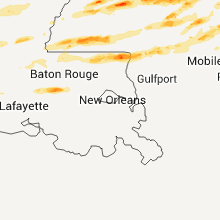
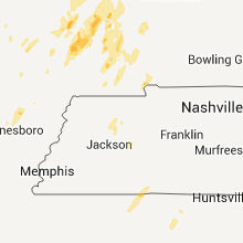
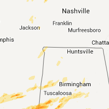
Hail Map for Friday, April 15, 2011

Number of Impacted Households on 4/15/2011
0
Impacted by 1" or Larger Hail
0
Impacted by 1.75" or Larger Hail
0
Impacted by 2.5" or Larger Hail
Square Miles of Populated Area Impacted on 4/15/2011
0
Impacted by 1" or Larger Hail
0
Impacted by 1.75" or Larger Hail
0
Impacted by 2.5" or Larger Hail


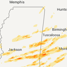


Cities Most Affected by Hail Storms of 4/15/2011
| Hail Size | Demographics of Zip Codes Affected | ||||||
|---|---|---|---|---|---|---|---|
| City | Count | Average | Largest | Pop Density | House Value | Income | Age |
| Quitman, MS | 4 | 2.63 | 4.25 | 27 | $56k | $31.4k | 40.9 |
| Linden, AL | 2 | 3.50 | 4.25 | 20 | $61k | $28.2k | 44.8 |
| Springfield, IL | 4 | 1.75 | 1.75 | 1989 | $64k | $31.8k | 33.3 |
| Scooba, MS | 2 | 2.38 | 2.75 | 6 | $55k | $24.1k | 30.5 |
| Meridian, MS | 2 | 2.25 | 2.75 | 181 | $74k | $34.1k | 37.2 |
| Mendenhall, MS | 2 | 2.25 | 2.50 | 52 | $62k | $29.2k | 38.1 |
| Hamilton, GA | 2 | 2.25 | 2.75 | 34 | $121k | $40.1k | 40.5 |
| Mccomb, MS | 2 | 2.13 | 2.50 | 222 | $56k | $23.8k | 34.9 |
| D Lo, MS | 2 | 1.88 | 2.00 | 0 | $39k | $30.0k | 41.4 |
| Gray Summit, MO | 2 | 1.75 | 1.75 | 181 | $79k | $45.5k | 43.3 |
| Hazlehurst, MS | 2 | 1.75 | 1.75 | 31 | $56k | $25.7k | 37.0 |
| Cape Girardeau, MO | 2 | 1.75 | 1.75 | 270 | $101k | $37.9k | 32.9 |
| Pennington, AL | 1 | 2.75 | 2.75 | 14 | $46k | $25.0k | 45.6 |
| Stonewall, MS | 1 | 2.75 | 2.75 | 53 | $46k | $24.2k | 42.7 |
| Jachin, AL | 1 | 2.75 | 2.75 | 14 | $81k | $11.0k | 47.3 |
| Lawrenceville, GA | 1 | 2.75 | 2.75 | 2417 | $0k | $0.0k | 32.0 |
| Sweet Water, AL | 1 | 2.50 | 2.50 | 11 | $42k | $28.6k | 42.8 |
| Waverly, IL | 1 | 2.00 | 2.00 | 23 | $60k | $38.8k | 41.6 |
| Zeigler, IL | 1 | 2.00 | 2.00 | 795 | $31k | $22.6k | 38.7 |
| Weir, MS | 1 | 2.00 | 2.00 | 23 | $51k | $27.1k | 41.7 |
| Auburn, AL | 1 | 1.75 | 1.75 | 401 | $135k | $27.2k | 28.2 |
| Baton Rouge, LA | 1 | 1.75 | 1.75 | 1513 | $134k | $55.7k | 34.1 |
| Summit, MS | 1 | 1.75 | 1.75 | 60 | $71k | $28.6k | 39.0 |
| Hickory, MS | 1 | 1.75 | 1.75 | 22 | $55k | $27.3k | 37.2 |
| Kevil, KY | 1 | 1.75 | 1.75 | 42 | $69k | $37.3k | 41.2 |
| Millry, AL | 1 | 1.75 | 1.75 | 14 | $57k | $30.1k | 42.0 |
| Manchester, GA | 1 | 1.75 | 1.75 | 140 | $66k | $28.4k | 38.2 |
| Bay Springs, MS | 1 | 1.75 | 1.75 | 28 | $55k | $24.9k | 39.6 |
| Tylertown, MS | 1 | 1.75 | 1.75 | 42 | $58k | $22.7k | 37.9 |
| Wagarville, AL | 1 | 1.75 | 1.75 | 9 | $72k | $36.3k | 39.3 |
| West Point, GA | 1 | 1.75 | 1.75 | 71 | $76k | $32.6k | 39.0 |
| Atlanta, GA | 1 | 1.75 | 1.75 | 1382 | $541k | $114.7k | 44.9 |
| Scott City, MO | 1 | 1.75 | 1.75 | 124 | $72k | $35.7k | 37.8 |
| French Camp, MS | 1 | 1.75 | 1.75 | 15 | $57k | $25.4k | 37.9 |
| Ruth, MS | 1 | 1.75 | 1.75 | 34 | $63k | $38.5k | 39.0 |
| Pawnee, IL | 1 | 1.75 | 1.75 | 29 | $84k | $50.0k | 38.1 |
| Crystal Springs, MS | 1 | 1.75 | 1.75 | 76 | $52k | $26.7k | 38.0 |
| Lake, MS | 1 | 1.75 | 1.75 | 26 | $50k | $25.1k | 36.8 |
| Waynesboro, MS | 1 | 1.75 | 1.75 | 31 | $57k | $26.2k | 37.1 |
| Angie, LA | 1 | 1.75 | 1.75 | 45 | $45k | $25.4k | 39.3 |
| Lumberton, MS | 1 | 1.75 | 1.75 | 28 | $56k | $25.0k | 38.8 |
| Florence, MS | 1 | 1.75 | 1.75 | 127 | $91k | $40.8k | 37.4 |
| Marion, MS | 1 | 1.75 | 1.75 | 573 | $0k | $0.0k | 29.9 |
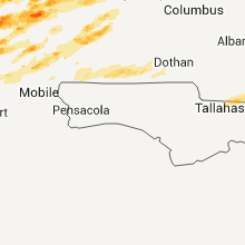
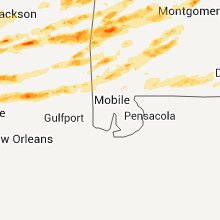
Hail and Wind Damage Spotted on 4/15/2011
Filter by Report Type:Hail ReportsWind Reports
States Impacted
Mississippi, Tennessee, Louisiana, Alabama, Missouri, Georgia, Arkansas, Illinois, Kentucky, Oklahoma, Indiana, OhioMississippi
| Local Time | Report Details |
|---|---|
| 12:00 PM UTC | A few trees reported down in coffeevill in yalobusha county MS, 61.2 miles NW of Starkville, MS |
| 12:00 PM UTC | A tree was downed along jackson ave...and a light pole was partially leaning in grenada county MS, 61.4 miles WNW of Starkville, MS |
| 12:00 PM UTC | A tree was downed along koppers dr in grenada county MS, 59.2 miles WNW of Starkville, MS |
| 12:10 PM UTC | Trees downed...blocking gums crossing rd in eastern grenada c in grenada county MS, 53 miles WNW of Starkville, MS |
| 12:25 PM UTC | A few trees were downed along old benton rd in yazoo county MS, 38.4 miles NNW of Jackson, MS |
| 12:44 PM UTC | Tree reported down at the intersection of foot street and washington/polk streets in corint in alcorn county MS, 48.9 miles WNW of Florence, AL |
| 12:50 PM UTC | Porch destroyed and lifted over a mobile home in ran in pontotoc county MS, 53.3 miles NNW of Starkville, MS |
| 1:00 PM UTC | Several trees down across the southern portions of pontotoc count in pontotoc county MS, 53.3 miles NNW of Starkville, MS |
| 1:00 PM UTC | Numerous trees down in the town of van vleet. a roof was blown off a mobile home. the roof of a porch was lifted and blown over a house. a tree fell also fell onto a ho in chickasaw county MS, 36.5 miles N of Starkville, MS |
| 1:06 PM UTC | Multiple trees down along new salem roa in pontotoc county MS, 43.3 miles N of Starkville, MS |
| 1:53 PM UTC | Half Dollar sized hail reported near West, MS, 57.2 miles WSW of Starkville, MS |
| 2:48 PM UTC | Showroom window blown out at atwood car lot in warren county MS, 40.4 miles W of Jackson, MS |
| 2:55 PM UTC | Trees downed blocking us highway 61 in the 7000 block in warren county MS, 44.2 miles W of Jackson, MS |
| 2:55 PM UTC | Several trees down in and south of vicksburg. one fell on an 18 wheeler on highway 61 and another fell on a house in oak park in warren county MS, 40.4 miles W of Jackson, MS |
| 3:00 PM UTC | Trees were downed along lakewood hill rd in warren county MS, 39.2 miles W of Jackson, MS |
| 3:03 PM UTC | Power pole down near home depot in vicksburg in warren county MS, 40.4 miles W of Jackson, MS |
| 3:05 PM UTC | Estimated wind gust with 1 tree down in the vicinity in warren county MS, 40.4 miles W of Jackson, MS |
| 3:40 PM UTC | Tree downed across champion hill rd near bolton in hinds county MS, 16.7 miles WNW of Jackson, MS |
| 4:15 PM UTC | Shingles were blown off a roof...large tree fell on a car near the wayne/clark co line just east of matherville. penny hail also occurre in clarke county MS, 74.8 miles W of Camden, AL |
| 5:52 PM UTC | Quarter sized hail reported near Philadelphia, MS, 47.9 miles S of Starkville, MS |
| 5:52 PM UTC | Trees down in central and northern parts of the county. one fell on an 18 wheeler i-55 at mile marker 68 in copiah county MS, 25.6 miles SSW of Jackson, MS |
| 5:53 PM UTC | Golf Ball sized hail reported near Crystal Springs, MS, 23.7 miles SSW of Jackson, MS |
| 5:55 PM UTC | Quarter sized hail reported near Crystal Springs, MS, 21.1 miles SSW of Jackson, MS |
| 5:55 PM UTC | Mobile home damaged on county road 729. possible tornado based on rada in neshoba county MS, 50 miles S of Starkville, MS |
| 6:00 PM UTC | Quarter sized hail reported near Florence, MS, 17.3 miles S of Jackson, MS |
| 6:00 PM UTC | Quarter sized hail reported near Terry, MS, 17.8 miles SSW of Jackson, MS |
| 6:00 PM UTC | Quarter sized hail reported near Terry, MS, 17.3 miles SSW of Jackson, MS |
| 6:11 PM UTC | Numerous trees down...one on a house in kemper county MS, 46.9 miles S of Starkville, MS |
| 6:15 PM UTC | Golf Ball sized hail reported near Florence, MS, 19.8 miles SSE of Jackson, MS |
| 6:35 PM UTC | Golf Ball sized hail reported near Hazlehurst, MS, 33.3 miles SSW of Jackson, MS |
| 6:39 PM UTC | Baseball sized hail reported near Scooba, MS, 46.1 miles SSE of Starkville, MS, baseball hail dented a vehicle on binnsville road near the alabama state line. |
| 6:52 PM UTC | Trees down along highway 18 in smith county MS, 32.8 miles ESE of Jackson, MS |
| 6:55 PM UTC | Trees down in powerlines around georgetown and east across the pearl river in simpson county in copiah county MS, 29.6 miles S of Jackson, MS |
| 7:05 PM UTC | 50-70 mph wind gust as well as pea size hail were reporte in kemper county MS, 48.3 miles S of Starkville, MS |
| 7:10 PM UTC | Golf Ball sized hail reported near Lake, MS, 41.8 miles E of Jackson, MS |
| 7:11 PM UTC | A large tree was uprooted and laying across highway 12. several large limbs were also down in the same are in holmes county MS, 57 miles NNE of Jackson, MS |
| 7:15 PM UTC | A swath of straight line wind damage affected the south through east sides of mendenhall between 215 and 230 pm. numerous trees were uprooted and snapped...a number fel in simpson county MS, 31.4 miles SSE of Jackson, MS |
| 7:16 PM UTC | Golf Ball sized hail reported near D'Lo, MS, 26.9 miles SE of Jackson, MS |
| 7:20 PM UTC | Hen Egg sized hail reported near D'Lo, MS, 26.9 miles SE of Jackson, MS, golfball to hen egg size hail was reported. |
| 7:20 PM UTC | Hen Egg sized hail reported near Mendenhall, MS, 29.6 miles SE of Jackson, MS, larger than golf ball sized hail |
| 7:20 PM UTC | Trees down blocking hwy 39 in kemper county MS, 55.6 miles S of Starkville, MS |
| 7:25 PM UTC | Tennis Ball sized hail reported near Mendenhall, MS, 31.5 miles SE of Jackson, MS |
| 7:29 PM UTC | Ping Pong Ball sized hail reported near Mendenhall, MS, 30.7 miles SE of Jackson, MS |
| 7:33 PM UTC | Hen Egg sized hail reported near De Kalb, MS, 49.7 miles SSE of Starkville, MS, hail just larger than hen egg...2.25 in |
| 7:33 PM UTC | Several trees down in adams county MS, 87.8 miles SW of Jackson, MS |
| 7:39 PM UTC | Ping Pong Ball sized hail reported near Scooba, MS, 47.9 miles SSE of Starkville, MS |
| 7:40 PM UTC | Golf Ball sized hail reported near French Camp, MS, 36 miles WSW of Starkville, MS |
| 7:44 PM UTC | Quarter sized hail reported near Newton, MS, 59.7 miles E of Jackson, MS |
| 7:47 PM UTC | Hen Egg sized hail reported near Scooba, MS, 49.7 miles SSE of Starkville, MS |
| 7:52 PM UTC | Hen Egg sized hail reported near Weir, MS, 32.5 miles WSW of Starkville, MS |
| 7:54 PM UTC | Golf Ball sized hail reported near Hickory, MS, 69.1 miles E of Jackson, MS |
| 7:56 PM UTC | Baseball sized hail reported near Meridian, MS, 76.7 miles E of Jackson, MS |
| 8:00 PM UTC | Quarter sized hail reported near Meridian, MS, 76.7 miles E of Jackson, MS |
| 8:10 PM UTC | Trees and powerlines down. one tree down on a house...and another down on a ca in lauderdale county MS, 72.9 miles S of Starkville, MS |
| 3:15 PM CDT | Golf Ball sized hail reported near Meridian, MS, 72.3 miles S of Starkville, MS |
| 8:15 PM UTC | Golf Ball sized hail reported near Bay Springs, MS, 62.8 miles ESE of Jackson, MS, reported by mhp officer |
| 8:25 PM UTC | Storm damage reported in lauderdale county MS, 72 miles S of Starkville, MS |
| 8:25 PM UTC | Golf Ball sized hail reported near Marion, MS, 72 miles S of Starkville, MS |
| 8:37 PM UTC | Quarter sized hail reported near McCool, MS, 35.6 miles WSW of Starkville, MS |
| 8:45 PM UTC | A few trees were blown down along cr 121 in the elwood communit in clarke county MS, 84.6 miles ESE of Jackson, MS |
| 8:46 PM UTC | Golf Ball sized hail reported near Hazlehurst, MS, 32.6 miles SSW of Jackson, MS |
| 8:46 PM UTC | Baseball sized hail reported near Stonewall, MS, 81.6 miles E of Jackson, MS, baseball sized hail broke some windows out of vehicles. |
| 8:46 PM UTC | Possible tornado downed 8 trees in thompson community in amite county MS, 79.3 miles SSW of Jackson, MS |
| 8:50 PM UTC | Quarter sized hail reported near Clinton, MS, 9.2 miles WNW of Jackson, MS, quarter hail reported. |
| 8:50 PM UTC | Golf Ball sized hail reported near Enterprise, MS, 82.3 miles ESE of Jackson, MS |
| 8:58 PM UTC | Half Dollar sized hail reported near Quitman, MS, 83.5 miles W of Camden, AL, dime...quarter...and half dollar size hail fell |
| 8:59 PM UTC | Quarter sized hail reported near McComb, MS, 74.2 miles SSW of Jackson, MS, hail observed on interstate 10 |
| 9:00 PM UTC | Golf Ball sized hail reported near Summit, MS, 72.2 miles SSW of Jackson, MS, large hail with 70 mph wind gusts on interstate 55. |
| 9:05 PM UTC | Quarter sized hail reported near Columbus, MS, 23.8 miles ENE of Starkville, MS, official obs at air force base |
| 9:05 PM UTC | Golf Ball sized hail reported near McComb, MS, 74.2 miles SSW of Jackson, MS, observed large hail at hampton inn in mccomb. |
| 9:05 PM UTC | Golf Ball sized hail reported near Ruth, MS, 64.5 miles S of Jackson, MS |
| 9:10 PM UTC | Structural damage to homes...trees down...possible tornado in clarke county MS, 70.3 miles W of Camden, AL |
| 9:13 PM UTC | Tennis Ball sized hail reported near McComb, MS, 73.5 miles S of Jackson, MS |
| 9:15 PM UTC | Wind damage blown on house reported by pike county civil defens in pike county MS, 73.7 miles SSW of Jackson, MS |
| 9:18 PM UTC | Several trees were downed around mendenhall. three homes were damaged by fallen trees. power lines were downed across us highway 4 in simpson county MS, 29.6 miles SE of Jackson, MS |
| 9:24 PM UTC | Golf Ball sized hail reported near Tylertown, MS, 75 miles S of Jackson, MS, golf ball sized hail reported by emergency manager near hwy 583 and east sunny hill road. |
| 9:58 PM UTC | Half Dollar sized hail reported near Hickory, MS, 68.6 miles E of Jackson, MS |
| 10:00 PM UTC | A couple trees down an many large limbs in marion county MS, 69 miles SSE of Jackson, MS |
| 10:00 PM UTC | Several trees down along cr 1537 with one on a house...possible tornad in jasper county MS, 57.6 miles ESE of Jackson, MS |
| 10:00 PM UTC | Ping Pong Ball sized hail reported near Columbia, MS, 69 miles SSE of Jackson, MS |
| 10:15 PM UTC | Quarter sized hail reported near Meridian, MS, 76.7 miles E of Jackson, MS, reported at lost gap |
| 10:18 PM UTC | A roof was blown off a barn along suqualena meehan rd. debris from the barn caused damage to a nearby hous in lauderdale county MS, 76.2 miles E of Jackson, MS |
| 10:21 PM UTC | Quarter sized hail reported near Blue Springs, MS, 65.8 miles N of Starkville, MS, 2 miles east of ellistown nickel to quarter size hail. |
| 10:30 PM UTC | Quarter sized hail reported near Quitman, MS, 83.3 miles ESE of Jackson, MS |
| 10:30 PM UTC | Hen Egg sized hail reported near Enterprise, MS, 82.3 miles ESE of Jackson, MS, golf ball to hen egg sized hail |
| 10:30 PM UTC | A few trees down across cr 292...possible tornad in clarke county MS, 79.5 miles ESE of Jackson, MS |
| 10:30 PM UTC | A few trees down across cr 292...possible tornad in jasper county MS, 76.7 miles ESE of Jackson, MS |
| 10:35 PM UTC | Golf Ball sized hail reported near Quitman, MS, 84 miles W of Camden, AL, reported in the elwood community |
| 5:40 PM CDT | Grapefruit sized hail reported near Quitman, MS, 85.2 miles W of Camden, AL |
| 10:41 PM UTC | Along with pea hail in jones county MS, 73.6 miles SE of Jackson, MS |
| 10:42 PM UTC | Trees down...one on a mobile home in clarke county MS, 84 miles W of Camden, AL |
| 10:42 PM UTC | Golf Ball sized hail reported near Quitman, MS, 84 miles W of Camden, AL |
| 10:48 PM UTC | Baseball sized hail reported near Quitman, MS, 82.9 miles W of Camden, AL, near clarkco state park. ended around 6 pm. |
| 10:54 PM UTC | A few trees were blown down along with numerous large limbs...pea hail also occurre in jones county MS, 82.7 miles SE of Jackson, MS |
| 11:15 PM UTC | Quarter sized hail reported near Poplarville, MS, 75.4 miles NNE of New Orleans, LA |
| 11:22 PM UTC | Half Dollar sized hail reported near Quitman, MS, 84 miles W of Camden, AL |
| 11:23 PM UTC | Golf Ball sized hail reported near Lumberton, MS, 81.2 miles NNE of New Orleans, LA |
| 11:27 PM UTC | Quarter sized hail reported near Quitman, MS, 84 miles W of Camden, AL |
| 11:30 PM UTC | Golf Ball sized hail reported near Waynesboro, MS, 72.5 miles NNW of Mobile, AL, golf ball size hail reported on hwy 63 |
| 1:37 AM UTC | Quarter sized hail reported near Brooklyn, MS, 72.6 miles WNW of Mobile, AL, reported near carnes road and highway 49. |
Tennessee
| Local Time | Report Details |
|---|---|
| 12:20 PM UTC | Trees down covering the roads in scotts hill. also trees reported down in western henderson count in henderson county TN, 44.9 miles SSE of Mc Kenzie, TN |
| 5:15 PM UTC | Trained spotter rpts trees uprooted and patio furniture blown across road in robertson county TN, 25.7 miles NNE of Nashville, TN |
| 6:42 PM UTC | Tree blown down on a house at ewing blvd and a tree blown down on a car along north walnut s in rutherford county TN, 30.9 miles SE of Nashville, TN |
| 8:45 PM UTC | Quarter sized hail reported near Halls, TN, 52.5 miles WSW of Mc Kenzie, TN, quarter size hail. |
| 9:30 PM UTC | Quarter sized hail reported near Union City, TN, 35.6 miles NW of Mc Kenzie, TN, quarter size hail reported by ham radio operator in union city. |
| 9:36 PM UTC | Quarter sized hail reported near Dyer, TN, 26.7 miles W of Mc Kenzie, TN, quarter size hail in dyer. |
| 11:28 PM UTC | Quarter sized hail reported near Bradford, TN, 17.2 miles WSW of Mc Kenzie, TN, pea to quarter size hail reported near the intersection of mulberry road and old hwy 45. |
| 11:30 PM UTC | Quarter sized hail reported near Greenfield, TN, 10.6 miles W of Mc Kenzie, TN, dime to quarter size hail covering the ground. |
| 12:28 AM UTC | Quarter sized hail reported near Paris, TN, 16.4 miles NE of Mc Kenzie, TN, quarter size hail in the town of paris. |
| 1:00 AM UTC | Quarter sized hail reported near Hollow Rock, TN, 15.4 miles ESE of Mc Kenzie, TN, pea to nickel size hail...with some pieces as large as quarter. |
| 1:15 AM UTC | Quarter sized hail reported near Brentwood, TN, 11 miles S of Nashville, TN, quarter size hail reported by spotter near brentwood. |
| 1:15 AM UTC | Railroad signal gate blown down at stewarts ferry and mc campbell r in davidson county TN, 4.6 miles SE of Nashville, TN |
| 1:20 AM UTC | Spotter reported a tree blown down in la vergn in rutherford county TN, 16.4 miles SE of Nashville, TN |
| 1:31 AM UTC | Storm damage reported in wilson county TN, 18.7 miles E of Nashville, TN |
| 1:40 AM UTC | Wilson county emergency management reported trees and power lines blown down on central pike near lebano in wilson county TN, 21.7 miles E of Nashville, TN |
Louisiana
| Local Time | Report Details |
|---|---|
| 1:14 PM UTC | Trees down near the community of hicks in vernon county LA, 88 miles NNE of Beaumont, TX |
| 1:15 PM UTC | Received photos of 2 trees downed near hick in vernon county LA, 88 miles NNE of Beaumont, TX |
| 1:50 PM UTC | Trees down on hwy 288 in rapides county LA, 76.2 miles NNW of Lafayette, LA |
| 2:00 PM UTC | Quarter sized hail reported near Woodworth, LA, 75.3 miles NNW of Lafayette, LA, quarter size hail between woodworth and alexandria. |
| 2:00 PM UTC | Trees down on hwy 288 in rapides county LA, 76.2 miles NNW of Lafayette, LA |
| 2:30 PM UTC | Trees and powerlines down in tensas county LA, 62.8 miles SE of Bastrop, LA |
| 8:05 PM UTC | Nws storm survey found downburst wind damage along highway 361 about 2 miles north of lebeau. one large tree and several large tree limbs were blown down. winds estimat in st. landry county LA, 36.6 miles N of Lafayette, LA |
| 8:20 PM UTC | Nws storm survey found a large intense downburst caused widespread wind damage in and around bayou current. numerous large trees were snapped or uprooted along highway in st. landry county LA, 42 miles NNE of Lafayette, LA |
| 8:20 PM UTC | Nws storm survey found a large intense downburst caused widespread wind damage in and around bayou current. numerous large trees were snapped or uprooted along highway in st. landry county LA, 42 miles NNE of Lafayette, LA |
| 8:41 PM UTC | Several trees downed and nickel size hail were reported by publi in east feliciana county LA, 74.3 miles NE of Lafayette, LA |
| 9:36 PM UTC | Quarter sized hail reported near Grosse Tete, LA, 36.9 miles ENE of Lafayette, LA |
| 9:44 PM UTC | Quarter sized hail reported near Plaquemine, LA, 46.7 miles E of Lafayette, LA, quarter size in plaquemine near dow chemical. |
| 9:48 PM UTC | Quarter sized hail reported near Baton Rouge, LA, 55.3 miles ENE of Lafayette, LA, quarter size in riverbend subdivision in baton rouge. |
| 9:51 PM UTC | Quarter sized hail reported near Addis, LA, 45.5 miles ENE of Lafayette, LA |
| 9:55 PM UTC | Quarter sized hail reported near Baton Rouge, LA, 55.3 miles ENE of Lafayette, LA, quarter size hail on jones creek road. |
| 9:55 PM UTC | Quarter sized hail reported near Kentwood, LA, 67.1 miles NNW of New Orleans, LA, several tree downed |
| 10:00 PM UTC | Golf Ball sized hail reported near Baton Rouge, LA, 56.4 miles E of Lafayette, LA, golf ball size hail reported at mall of louisiana along with a rotating wall cloud. |
| 10:05 PM UTC | Quarter sized hail reported near Kentwood, LA, 66.3 miles NNW of New Orleans, LA, several tree downed |
| 10:13 PM UTC | Several tree downed on lawrence creek road and pea size hail in pine in washington county LA, 63.9 miles N of New Orleans, LA |
| 10:45 PM UTC | Golf Ball sized hail reported near Angie, LA, 71 miles NNE of New Orleans, LA, mayor reported large hail covering the yard. |
Alabama
| Local Time | Report Details |
|---|---|
| 3:37 PM UTC | Large tree down across county road 14 near oaklan in lauderdale county AL, 7.6 miles WNW of Florence, AL |
| 4:00 PM UTC | Golf Ball sized hail reported near Wagarville, AL, 47.8 miles N of Mobile, AL, golfball size hail reported by public. |
| 4:02 PM UTC | Quarter sized hail reported near Birmingham, AL, 0.9 miles NE of Birmingham, AL, quarter sized hail in downtown birmingham. |
| 4:45 PM UTC | Trees reported down and several homes sustained structural damag in washington county AL, 57.4 miles NNW of Mobile, AL |
| 4:56 PM UTC | Large tree down atop a manufactured home. 3 people trapped inside but no reports of injuries at this tim in choctaw county AL, 52.2 miles W of Camden, AL |
| 5:05 PM UTC | Golf Ball sized hail reported near Millry, AL, 65.5 miles WSW of Camden, AL, golf ball size hail reported. |
| 5:30 PM UTC | Few trees down from fern bank to hightog in lamar county AL, 44.5 miles ENE of Starkville, MS |
| 5:34 PM UTC | Quarter sized hail reported near Blountsville, AL, 43.4 miles NNE of Birmingham, AL, quarter size hail along hwy 49. |
| 6:18 PM UTC | Trees doww 3 wsw of freetown. possible tornad in marengo county AL, 31.6 miles NNW of Camden, AL |
| 6:18 PM UTC | Trees doww 3 wsw of freetow. possible tornad in marengo county AL, 31.6 miles NNW of Camden, AL |
| 6:56 PM UTC | Probable tornado. multiple homes da in sumter county AL, 50.4 miles SE of Starkville, MS |
| 6:56 PM UTC | Cuba vfd reports numerous trees down and blocking old bodka road near geiger. winds estimated 90 mp in sumter county AL, 52.1 miles SE of Starkville, MS |
| 6:56 PM UTC | Cuba vfd reports numerous trees down and blocking old bodka road near geiger. winds estimated 90 mp in lowndes county AL, 37.2 miles E of Camden, AL |
| 7:03 PM UTC | Cuba vfd reports many trees down in the geiger area... possible tornad in sumter county AL, 50.4 miles SE of Starkville, MS |
| 7:05 PM UTC | A tree fell on a home at 309 east spruce street in jackson a in clarke county AL, 48 miles SW of Camden, AL |
| 7:06 PM UTC | Cuba vfd reports numerous trees down and blocking old bodka road in emelle. winds estimated 90 mp in sumter county AL, 58.2 miles SSE of Starkville, MS |
| 7:45 PM UTC | *** 1 inj *** probable tornado. tree collapsed roof and ceiling of home pinning elderly woman. transported to hospital with unknown injurie in sumter county AL, 50.4 miles SE of Starkville, MS |
| 7:45 PM UTC | Probable tornado. multiple homes da in sumter county AL, 50.4 miles SE of Starkville, MS |
| 8:00 PM UTC | Ema reported large tree down which fell on house and did extensive damage to a pickup truc in monroe county AL, 31.9 miles S of Camden, AL |
| 8:39 PM UTC | Tree down on power line in colbert county AL, 2.8 miles S of Florence, AL |
| 9:38 PM UTC | Quarter sized hail reported near Vernon, AL, 45.3 miles ENE of Starkville, MS |
| 9:38 PM UTC | Baseball sized hail reported near Jachin, AL, 56.2 miles WNW of Camden, AL, very large hail knocked the windshields out of cars. |
| 9:40 PM UTC | Quarter sized hail reported near Vernon, AL, 45.3 miles ENE of Starkville, MS |
| 9:50 PM UTC | Quarter sized hail reported near Helena, AL, 16 miles S of Birmingham, AL, quarter size hail in rocky ridge at jct hwys 17 and 58. |
| 9:55 PM UTC | Baseball sized hail reported near Pennington, AL, 47.5 miles WNW of Camden, AL, baseball size hail caused damage to the georgia pacific plant. winds and sunroofs were busted out of cars in the area. |
| 9:58 PM UTC | Large magnolia tree down along al hwy 150 near the hoover me in jefferson county AL, 9.7 miles S of Birmingham, AL |
| 10:00 PM UTC | Trees down on a couple of homes along hwy 31 near the fire statio in shelby county AL, 18.6 miles S of Birmingham, AL |
| 10:00 PM UTC | Grapefruit sized hail reported near Linden, AL, 42.5 miles WNW of Camden, AL |
| 10:05 PM UTC | Possible tornado. 20 to 25 homes damaged. roads closed due to major damage north of greensboro. several hundred trees down in the count in hale county AL, 51.8 miles NNW of Camden, AL |
| 10:10 PM UTC | Quarter sized hail reported near Alabaster, AL, 18.6 miles S of Birmingham, AL, quarter size hail at city hall in downtown alab |
| 10:17 PM UTC | Quarter sized hail reported near Pelham, AL, 15.2 miles S of Birmingham, AL |
| 10:17 PM UTC | Tennis Ball sized hail reported near Sweet Water, AL, 40.9 miles WNW of Camden, AL |
| 10:17 PM UTC | Baseball sized hail reported near Linden, AL, 42.5 miles WNW of Camden, AL |
| 10:20 PM UTC | Quarter sized hail reported near Pelham, AL, 15.2 miles S of Birmingham, AL, quarter size hail off cr 52 in deering downs subdivision. |
| 10:25 PM UTC | Quarter sized hail reported near Calera, AL, 24.9 miles S of Birmingham, AL, nickle to quarter size hail reported in the scottsville subdivision. |
| 10:25 PM UTC | Quarter sized hail reported near Alabaster, AL, 20.7 miles S of Birmingham, AL, nickle to quarter size hail reported in the scottsdale subdivision. |
| 10:27 PM UTC | Damage to siding on fire station buildin in shelby county AL, 16.4 miles SE of Birmingham, AL |
| 10:30 PM UTC | Quarter sized hail reported near Chelsea, AL, 16.4 miles SE of Birmingham, AL |
| 5:54 PM CDT | Golf Ball sized hail reported near Auburn, AL, 1.2 miles S of Auburn, AL, university drive |
| 11:25 PM UTC | Roof removed from mobile home. trees and powerlines dow in lee county AL, 1.2 miles S of Auburn, AL |
| 12:00 AM UTC | Spotter observed 75 mph winds on a hand held anemometer 1 mile southeast of scuttle...with several trees dow in perry county AL, 37.4 miles N of Camden, AL |
| 12:00 AM UTC | Spotter observed 75 mph winds on a hand held anemometer 1 mile southeast of suttle...with several trees dow in perry county AL, 37.4 miles N of Camden, AL |
| 12:05 AM UTC | Trees down and blocking sr 2 in dallas county AL, 47.1 miles NNE of Camden, AL |
| 12:26 AM UTC | Tree down on ballard roa in perry county AL, 43.9 miles N of Camden, AL |
| 1:12 AM UTC | Quarter sized hail reported near Selma, AL, 33.4 miles NNE of Camden, AL, downtown selma |
| 1:50 AM UTC | Trees down at hwy 82 and cr 40 in independence. possible tornad in autauga county AL, 49.2 miles NE of Camden, AL |
| 2:15 AM UTC | Trees down at cr56 and cr43. possible tornad in autauga county AL, 58 miles W of Auburn, AL |
| 2:26 AM UTC | Possible tornado in the titus community. downed in elmore county AL, 49.4 miles W of Auburn, AL |
| 2:32 AM UTC | A tree was knocked down at the intersection of highway 75 and highway 4 in dekalb county AL, 38.1 miles SW of Chattanooga, TN |
| 2:35 AM UTC | 25 trees down at cr9 and al14 in autauga county AL, 43.9 miles NE of Camden, AL |
| 3:40 AM UTC | A tree was knocked down along county road 67 in dekalb county AL, 36.5 miles SW of Chattanooga, TN |
| 4:40 AM UTC | Numerous trees down in and around wind creek state park. possible tornad in tallapoosa county AL, 31.9 miles WNW of Auburn, AL |
| 4:45 AM UTC | Trees and powerlines down near hwy 3 in montgomery county AL, 53.3 miles E of Camden, AL |
| 4:45 AM UTC | Trees and powerlines down near hwy 3 in montgomery county AL, 54.8 miles E of Camden, AL |
| 4:55 AM UTC | Trees down along sherling lake rd. north of greenville. other trees down in area and around the count in butler county AL, 39.9 miles ESE of Camden, AL |
| 5:13 AM UTC | Signs in a shopping center blown down in the wadley are in randolph county AL, 35.7 miles N of Auburn, AL |
| 5:27 AM UTC | Large tree fell on hom in randolph county AL, 37.8 miles N of Auburn, AL |
| 5:48 AM UTC | Quarter sized hail reported near Andalusia, AL, 64.8 miles N of Miramar Beach, FL, one inch hail reported on lindsey bridge rd. in andalusia. |
| 6:10 AM UTC | Numerous trees down in andalusia...kiwanis bldg damaged on s. end of tow in covington county AL, 64.8 miles N of Miramar Beach, FL |
| 7:00 AM UTC | Two residences had minor damage with trees down a power line snapped on county road 20 just off of highway 27 near ewel in dale county AL, 82 miles S of Auburn, AL |
| 7:00 AM UTC | Several trees were blown down with one outbuilding destroye in dale county AL, 82.3 miles NNE of Miramar Beach, FL |
Missouri
| Local Time | Report Details |
|---|---|
| 6:35 PM UTC | Quarter sized hail reported near Bowling Green, MO, 66.5 miles ENE of Columbia, MO |
| 7:00 PM UTC | Half Dollar sized hail reported near Monroe City, MO, 53.2 miles S of Kahoka, MO |
| 8:06 PM UTC | Golf Ball sized hail reported near Gray Summit, MO, 34.9 miles WSW of Saint Louis, MO |
| 8:07 PM UTC | Golf Ball sized hail reported near Gray Summit, MO, 34.9 miles WSW of Saint Louis, MO |
| 8:56 PM UTC | Quarter sized hail reported near High Ridge, MO, 21.3 miles WSW of Saint Louis, MO |
| 9:13 PM UTC | Quarter sized hail reported near Fredericktown, MO, 45.2 miles WNW of Cape Girardeau, MO |
| 9:47 PM UTC | Quarter sized hail reported near Scott City, MO, 5.8 miles S of Cape Girardeau, MO |
| 9:47 PM UTC | Em director reports shed destroyed and damage to the under pinning of a double wide near oran on 26 in scott county MO, 16.4 miles SSW of Cape Girardeau, MO |
| 9:50 PM UTC | Golf Ball sized hail reported near Scott City, MO, 5.8 miles S of Cape Girardeau, MO |
| 9:54 PM UTC | Quarter sized hail reported near St Louis, MO, 2.3 miles WNW of Saint Louis, MO, hail in st. louis city at broadway and hwy 55. |
| 9:55 PM UTC | Golf Ball sized hail reported near Cape Girardeau, MO, 0.6 miles NNW of Cape Girardeau, MO, ping pong to golf ball size hail reported in the downtown area. |
| 10:04 PM UTC | Quarter sized hail reported near Scott City, MO, 5.8 miles S of Cape Girardeau, MO, spotter driving along i-55 at mile marker 85 towards scott city reports 1 inch hail |
| 10:04 PM UTC | Golf Ball sized hail reported near Cape Girardeau, MO, 0.6 miles NNW of Cape Girardeau, MO, spotter reports golf ball sized hail in cape girardeau |
| 10:08 PM UTC | Quarter sized hail reported near Cape Girardeau, MO, 0.6 miles NNW of Cape Girardeau, MO |
Georgia
| Local Time | Report Details |
|---|---|
| 8:33 PM UTC | A nws storm survey team determined that straight line winds with speeds up to 80 mph hit the rome area. 50 to 100 trees were reported down in the area. damage was conta in floyd county GA, 54.6 miles S of Chattanooga, TN |
| 8:33 PM UTC | Floyd county ema relayed a report of widespread tree damage across floyd count in floyd county GA, 54.6 miles S of Chattanooga, TN |
| 8:34 PM UTC | Quarter sized hail reported near Rome, GA, 54.6 miles S of Chattanooga, TN, floyd county ema relayed a report of quarter sized hail in rome. damage to cars has been reported. |
| 4:39 PM EDT | Quarter sized hail reported near Rome, GA, 55 miles S of Chattanooga, TN |
| 4:57 PM EDT | Ping Pong Ball sized hail reported near Adairsville, GA, 51.9 miles SSE of Chattanooga, TN, amatuer radio relayed a report of pnig pong size hail near adairsville. |
| 8:57 PM UTC | Off duty nws meteorologist reported 60 mph winds at exit 305 on i75. the meteorologist also reported 4 trees dow in bartow county GA, 51.5 miles NNW of Atlanta, GA |
| 9:02 PM UTC | Bartow county 911 relayed a report of numerous trees down in the adairsville are in bartow county GA, 51.9 miles SSE of Chattanooga, TN |
| 9:11 PM UTC | Gordon county ema relayed a report of widespread tree damage along with some downed power lines in southeast gordon count in gordon county GA, 50.9 miles NNW of Atlanta, GA |
| 9:15 PM UTC | Half Dollar sized hail reported near Jasper, GA, 49.8 miles N of Atlanta, GA |
| 9:15 PM UTC | Half Dollar sized hail reported near Calhoun, GA, 49.3 miles SSE of Chattanooga, TN |
| 9:15 PM UTC | Trees on house and powerline in gordon county GA, 49.3 miles SSE of Chattanooga, TN |
| 10:00 PM UTC | 15-20 trees down across the southern end of the count in gilmer county GA, 55.6 miles ESE of Chattanooga, TN |
| 10:30 PM UTC | Several trees dow in whitfield county GA, 27.1 miles SE of Chattanooga, TN |
| 10:30 PM UTC | Several trees dow in gordon county GA, 50.8 miles SE of Chattanooga, TN |
| 10:35 PM UTC | Ema relayed a report of a few trees down across southeast union count in union county GA, 75.2 miles S of Knoxville, TN |
| 10:37 PM UTC | Murray county 911 relayed a report of a tree down north of eto in murray county GA, 33.5 miles ESE of Chattanooga, TN |
| 10:40 PM UTC | Several trees dow in murray county GA, 36.1 miles ESE of Chattanooga, TN |
| 11:00 PM UTC | Several trees dow in murray county GA, 36.1 miles ESE of Chattanooga, TN |
| 11:21 PM UTC | Douglas county 911 relayed a report of a structual collapse in downtown douglasville. 911 also stated that there was widespread tree damage in the count in douglas county GA, 20.7 miles W of Atlanta, GA |
| 11:21 PM UTC | Douglas county 911 relayed a report that the roof of a business collapsed in downtown douglasville. dispatcher reported that collapse was caused by wind. 911 also state in douglas county GA, 20.7 miles W of Atlanta, GA |
| 11:28 PM UTC | Douglas county ema relayed a report of a building with its roof torn of in douglas county GA, 14.5 miles W of Atlanta, GA |
| 11:30 PM UTC | Harris county 911 relayed a report of numerous trees down in eastern harris county. tree damage started near highway 185 exit 19 and continued eas in harris county GA, 36.6 miles ENE of Auburn, AL |
| 7:35 PM EDT | Golf Ball sized hail reported near West Point, GA, 31.4 miles NE of Auburn, AL, hail broke windshield of car. |
| 11:42 PM UTC | Harris county relayed a report of trees down across the count in harris county GA, 36.6 miles ENE of Auburn, AL |
| 11:44 PM UTC | Cobb county 911 relayed a report of county wide tree damage and power lines dow in cobb county GA, 16.3 miles NNW of Atlanta, GA |
| 7:44 PM EDT | Baseball sized hail reported near Hamilton, GA, 36.6 miles ENE of Auburn, AL |
| 11:51 PM UTC | Quarter sized hail reported near Smyrna, GA, 10.3 miles NW of Atlanta, GA |
| 11:54 PM UTC | A couple of trees down in cobb county GA, 9.3 miles NW of Atlanta, GA |
| 7:55 PM EDT | Golf Ball sized hail reported near Hamilton, GA, 36.6 miles ENE of Auburn, AL, trees crashing down |
| 11:57 PM UTC | Quarter sized hail reported near Clayton, GA, 32.1 miles WNW of Greenville, SC |
| 11:57 PM UTC | Quarter sized hail reported near Hamilton, GA, 42.4 miles ENE of Auburn, AL |
| 12:00 AM UTC | Trees down on cars at i-75 and i-28 in cobb county GA, 13.7 miles NNW of Atlanta, GA |
| 8:05 PM EDT | Golf Ball sized hail reported near Atlanta, GA, 10.5 miles N of Atlanta, GA, at johnson ferry rd. near fulton-cobb county line. |
| 8:08 PM EDT | Fulton county ema relayed a report of tree down across the northern and central parts of the county. also reports that a house has collapsed in the sandy springs are in fulton county GA, 13.3 miles N of Atlanta, GA |
| 12:09 AM UTC | Golf Ball sized hail reported near Manchester, GA, 52.9 miles ENE of Auburn, AL |
| 8:14 PM EDT | Quarter sized hail reported near Atlanta, GA, 11.9 miles N of Atlanta, GA, near riverwood high school |
| 8:15 PM EDT | Quarter sized hail reported near Marietta, GA, 16.6 miles NNW of Atlanta, GA, near lake shore way...lasting about 10 minutes. |
| 8:45 PM EDT | Quarter sized hail reported near Marietta, GA, 13.9 miles N of Atlanta, GA |
| 12:46 AM UTC | Quarter sized hail reported near Buford, GA, 31.5 miles NE of Atlanta, GA |
| 1:05 AM UTC | Half Dollar sized hail reported near Buford, GA, 32.4 miles NE of Atlanta, GA, richmond hill subdivision. |
| 9:05 PM EDT | Baseball sized hail reported near Lawrenceville, GA, 27.3 miles ENE of Atlanta, GA |
| 1:08 AM UTC | Numerous trees down at green forest pkwy. road closed at so. cobb dr. and so. atlanta r in cobb county GA, 11.5 miles NW of Atlanta, GA |
| 1:20 AM UTC | Quarter sized hail reported near Forsyth, GA, 56 miles SSE of Atlanta, GA, structural fire from lightning...barn...at monroe and butts county line. |
| 1:55 AM UTC | At least six trees twisted and snapped half way u in gwinnett county GA, 22.7 miles ENE of Atlanta, GA |
| 1:56 AM UTC | Gwinnett county 911 relayed a report of one tree down in the snellville are in gwinnett county GA, 23.2 miles ENE of Atlanta, GA |
| 6:30 AM UTC | Several trees down on riley road and highway 5. roof gave in at 6602 bankhead highwa in douglas county GA, 20.7 miles W of Atlanta, GA |
| 6:30 AM UTC | Several trees dow in fulton county GA, 22.5 miles SW of Atlanta, GA |
| 6:39 AM UTC | Public reports a sign torn down at a strip mall on cobb parkway in vinings along with a downed tree in a neighboring parking lo in cobb county GA, 9.5 miles NNW of Atlanta, GA |
| 6:45 AM UTC | At least 11 trees down...4 on houses. portion of roof torn off at bj warehouse building on east west connecto in cobb county GA, 14.4 miles WNW of Atlanta, GA |
| 6:49 AM UTC | Quarter sized hail reported near Smyrna, GA, 11.4 miles NW of Atlanta, GA, reported at the intersection of kings spring road and south cobb drive. 52 mph wind gust also recorded. |
| 7:37 AM UTC | A nws storm survey team determined that straight line winds caused damage 2 miles ne of fortson in harris county. there was one tree with its top clipped off and 3 hous in harris county GA, 32.8 miles E of Auburn, AL |
| 8:36 AM UTC | Roof torn off building and cars overturned on fort benning. damage near 8th division road and old cusseta hwy. possible tornad in chattahoochee county GA, 39.8 miles ESE of Auburn, AL |
| 10:10 AM UTC | One tree down on hwy 8 in monroe county GA, 66 miles SSE of Atlanta, GA |
| 10:20 AM UTC | Few trees dow in bibb county GA, 71.7 miles SSE of Atlanta, GA |
| 10:22 AM UTC | One power line dow in jones county GA, 72.3 miles SE of Atlanta, GA |
Arkansas
| Local Time | Report Details |
|---|---|
| 8:46 PM UTC | Quarter sized hail reported near Paragould, AR, 79.8 miles NNW of Memphis, TN, quarter size hail reported 2 miles ene of evening star in greene county arkansas. |
| 10:54 PM UTC | Quarter sized hail reported near Weiner, AR, 53 miles NW of Memphis, TN, 1 mile west of greenfield pea to quarter size hail. |
Illinois
| Local Time | Report Details |
|---|---|
| 9:04 PM UTC | Quarter sized hail reported near Camp Point, IL, 44.2 miles ESE of Kahoka, MO |
| 10:13 PM UTC | Power lines down at 309 euclid on south side of tow in st. clair county IL, 35.2 miles SE of Saint Louis, MO |
| 10:15 PM UTC | Storm damage reported in alexander county IL, 13 miles SE of Cape Girardeau, MO |
| 10:17 PM UTC | Quarter sized hail reported near Wood River, IL, 17.3 miles NNE of Saint Louis, MO |
| 10:19 PM UTC | Power lines dow in st. clair county IL, 35.2 miles SE of Saint Louis, MO |
| 10:24 PM UTC | Pea size hail reported with the storm. location is near the intersection of hwys 152 and 15 in franklin county IL, 53 miles NNE of Cape Girardeau, MO |
| 10:24 PM UTC | Pea size hail reported with the storm. location is near the intersection of hwys 152 and 15 in perry county IL, 49.5 miles NNE of Cape Girardeau, MO |
| 10:28 PM UTC | Quarter sized hail reported near Mound City, IL, 25.8 miles SE of Cape Girardeau, MO, also had dime size hail west side of mounds |
| 10:30 PM UTC | Things blown over in yards. downed tree limb in alexander county IL, 13 miles SE of Cape Girardeau, MO |
| 10:33 PM UTC | Quarter sized hail reported near Belknap, IL, 38.3 miles E of Cape Girardeau, MO |
| 10:36 PM UTC | Quarter sized hail reported near Ullin, IL, 20.1 miles E of Cape Girardeau, MO |
| 10:40 PM UTC | Quarter sized hail reported near Carbondale, IL, 33.3 miles NNE of Cape Girardeau, MO |
| 10:40 PM UTC | Hen Egg sized hail reported near Waverly, IL, 67.5 miles N of Saint Louis, MO, delayed report |
| 10:42 PM UTC | Quarter sized hail reported near Carbondale, IL, 34.5 miles NE of Cape Girardeau, MO |
| 10:45 PM UTC | Golf Ball sized hail reported near Springfield, IL, 67.1 miles S of Peoria, IL, i-55 and toronto road |
| 10:45 PM UTC | Wind gusts estimated 50 to 60 mph with dime size hail reported with the stor in franklin county IL, 53.2 miles NE of Cape Girardeau, MO |
| 10:47 PM UTC | Dime size hail reported with the storm at the intersection of hwys 143 and interstate 5 in williamson county IL, 44.4 miles NE of Cape Girardeau, MO |
| 10:47 PM UTC | One half inch hail reported with the stor in williamson county IL, 40.6 miles NE of Cape Girardeau, MO |
| 10:49 PM UTC | Quarter sized hail reported near Carterville, IL, 40.6 miles NE of Cape Girardeau, MO, quarter size hail covering the ground at intersection of grand avenue and dent street. |
| 10:53 PM UTC | Quarter sized hail reported near Marion, IL, 44.4 miles NE of Cape Girardeau, MO, measured 60 mph winds associated with this storm. |
| 10:53 PM UTC | Quarter sized hail reported near Marion, IL, 42 miles NE of Cape Girardeau, MO, quarter size hail with wind gusts estimated 50 to 60 mph. |
| 10:55 PM UTC | Golf Ball sized hail reported near Springfield, IL, 63 miles S of Peoria, IL |
| 10:59 PM UTC | Golf Ball sized hail reported near Pawnee, IL, 64.8 miles W of Mattoon, IL |
| 10:59 PM UTC | Hen Egg sized hail reported near Zeigler, IL, 49.3 miles NNE of Cape Girardeau, MO, golf ball to hen egg size hail reported. report from 911 center. |
| 11:03 PM UTC | Quarter sized hail reported near Marion, IL, 44.4 miles NE of Cape Girardeau, MO, quarter size hail reported near the community of johnson city. |
| 11:05 PM UTC | Quarter sized hail reported near Lewistown, IL, 29.5 miles SW of Peoria, IL |
| 11:06 PM UTC | Quarter sized hail reported near Chatham, IL, 70.8 miles S of Peoria, IL |
| 11:06 PM UTC | Storm damage reported in fulton county IL, 27.1 miles WSW of Peoria, IL |
| 11:08 PM UTC | Roof partially blown off mobile home in clinton county IL, 56.3 miles E of Saint Louis, MO |
| 11:10 PM UTC | Quarter sized hail reported near Thompsonville, IL, 60.1 miles NE of Cape Girardeau, MO |
| 11:12 PM UTC | Golf Ball sized hail reported near Springfield, IL, 63 miles S of Peoria, IL, east side of lake springfield |
| 11:15 PM UTC | 5 inch diamter tree limbs dow in marion county IL, 58.4 miles E of Saint Louis, MO |
| 11:22 PM UTC | Golf Ball sized hail reported near Springfield, IL, 63 miles S of Peoria, IL, at abraham lincoln springfield capital airport |
| 11:26 PM UTC | 3-4 inch tree limbs down...many yard items blown 1-2 blocks down stree in marion county IL, 57.8 miles E of Saint Louis, MO |
| 11:30 PM UTC | Quarter sized hail reported near West Frankfort, IL, 53.2 miles NE of Cape Girardeau, MO |
| 11:30 PM UTC | Quarter sized hail reported near Ashland, IL, 51.9 miles SSW of Peoria, IL |
| 11:40 PM UTC | Quarter sized hail reported near Metropolis, IL, 47.2 miles ESE of Cape Girardeau, MO, quarter size hail reported. |
| 11:49 PM UTC | Quarter sized hail reported near Metropolis, IL, 47.2 miles ESE of Cape Girardeau, MO |
| 11:50 PM UTC | Tree down on house in clay county IL, 56.3 miles S of Mattoon, IL |
| 12:42 AM UTC | Quarter sized hail reported near Delavan, IL, 22.4 miles S of Peoria, IL |
Kentucky
| Local Time | Report Details |
|---|---|
| 10:20 PM UTC | Golf Ball sized hail reported near Kevil, KY, 32.5 miles ESE of Cape Girardeau, MO, reported just north of town. |
| 10:54 PM UTC | Quarter sized hail reported near Cunningham, KY, 43.9 miles SE of Cape Girardeau, MO, quarter size hail and wind gust 50 mph associated with this storm. |
| 11:25 PM UTC | Quarter sized hail reported near Wickliffe, KY, 42.1 miles ESE of Cape Girardeau, MO, quarter size hail reported between gage and kevil. |
| 11:31 PM UTC | Quarter sized hail reported near West Paducah, KY, 47 miles ESE of Cape Girardeau, MO, quarter size hail reported at national weather service office. |
| 11:39 PM UTC | Ping Pong Ball sized hail reported near Paducah, KY, 52.4 miles ESE of Cape Girardeau, MO |
| 11:39 PM UTC | Ping Pong Ball sized hail reported near West Paducah, KY, 47 miles ESE of Cape Girardeau, MO, occurred at the national weather service office near barkley regional airport. |
| 12:07 AM UTC | Quarter sized hail reported near Hickory, KY, 47.9 miles N of Mc Kenzie, TN, torrential rain reported with the storm. |
| 12:22 AM UTC | Quarter sized hail reported near Grand Rivers, KY, 70.1 miles E of Cape Girardeau, MO, quarter size hail reported near the community of burham. |
| 12:50 AM UTC | Ping Pong Ball sized hail reported near Hardin, KY, 47.5 miles NNE of Mc Kenzie, TN, ping pong hail fell near kenlake state park for 2 minutes. |
| 1:15 AM UTC | Trees down on line street and cerulean road in trigg county KY, 64 miles NE of Mc Kenzie, TN |
| 1:20 AM UTC | Trees down across the county in metcalfe county KY, 72.3 miles S of Louisville, KY |
| 2:15 AM UTC | In etoile...three barns received roof damage. trees downed in barren county KY, 66.6 miles NE of Nashville, TN |
| 2:20 AM UTC | Trees down across the county in metcalfe county KY, 72.3 miles S of Louisville, KY |
Oklahoma
| Local Time | Report Details |
|---|---|
| 11:19 PM UTC | Storm damage reported in oklahoma county OK, 8 miles WNW of Oklahoma City, OK |
Indiana
| Local Time | Report Details |
|---|---|
| 3:30 AM UTC | 10 homes damaged in the clear creek housing edition. 1 home with major roof damage. otherwise mainly vinyl siding and garage door damage reported. no injurie in hendricks county IN, 19.7 miles W of Indianapolis, IN |
| 4:00 AM UTC | 15 to 20 homes damaged in the clear creek housing edition. mainly vinyl siding and garage door damage reported. no injurie in hendricks county IN, 19.7 miles W of Indianapolis, IN |
Ohio
| Local Time | Report Details |
|---|---|
| 8:43 AM UTC | Corrected previous report to mph in clinton county OH, 42.5 miles ENE of Cincinnati, OH |
Connect with Interactive Hail Maps