

Hail Map for Sunday, April 19, 2015

Number of Impacted Households on 4/19/2015
0
Impacted by 1" or Larger Hail
0
Impacted by 1.75" or Larger Hail
0
Impacted by 2.5" or Larger Hail
Square Miles of Populated Area Impacted on 4/19/2015
0
Impacted by 1" or Larger Hail
0
Impacted by 1.75" or Larger Hail
0
Impacted by 2.5" or Larger Hail


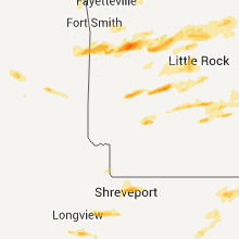
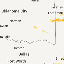


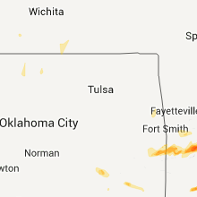


Cities Most Affected by Hail Storms of 4/19/2015
| Hail Size | Demographics of Zip Codes Affected | ||||||
|---|---|---|---|---|---|---|---|
| City | Count | Average | Largest | Pop Density | House Value | Income | Age |
| Houston, TX | 4 | 1.75 | 1.75 | 3234 | $115k | $54.1k | 34.0 |
| Hot Springs National Park, AR | 3 | 2.17 | 2.75 | 334 | $77k | $28.0k | 42.1 |
| Tomball, TX | 2 | 2.38 | 2.75 | 1262 | $125k | $54.4k | 32.1 |
| Midland, AR | 2 | 1.88 | 2.00 | 0 | $41k | $20.0k | 35.0 |
| Pine Bluff, AR | 2 | 1.88 | 2.00 | 196 | $64k | $35.5k | 39.4 |
| Caddo Gap, AR | 2 | 1.88 | 2.00 | 6 | $41k | $33.6k | 42.1 |
| Huntington, AR | 2 | 1.75 | 1.75 | 43 | $55k | $35.3k | 42.4 |
| Bastrop, TX | 2 | 1.75 | 1.75 | 118 | $107k | $46.0k | 39.2 |
| Little Rock, AR | 2 | 1.75 | 1.75 | 362 | $206k | $74.2k | 39.0 |
| Nacogdoches, TX | 2 | 1.75 | 1.75 | 241 | $0k | $0.0k | 29.4 |
| Smithville, TX | 2 | 1.75 | 1.75 | 47 | $82k | $37.2k | 43.9 |
| Glenwood, AR | 1 | 2.75 | 2.75 | 35 | $60k | $26.7k | 37.4 |
| Montgomery, LA | 1 | 2.75 | 2.75 | 17 | $45k | $29.9k | 42.2 |
| De Berry, TX | 1 | 2.75 | 2.75 | 15 | $47k | $31.8k | 41.5 |
| Caldwell, TX | 1 | 2.50 | 2.50 | 24 | $57k | $34.3k | 41.6 |
| Waller, TX | 1 | 2.00 | 2.00 | 64 | $92k | $43.0k | 37.7 |
| Kirbyville, TX | 1 | 2.00 | 2.00 | 30 | $50k | $28.5k | 42.1 |
| Benton, LA | 1 | 1.75 | 1.75 | 60 | $117k | $50.2k | 40.5 |
| Somerville, TX | 1 | 1.75 | 1.75 | 19 | $52k | $28.5k | 47.2 |
| Paris, AR | 1 | 1.75 | 1.75 | 34 | $55k | $26.4k | 43.9 |
| Hempstead, TX | 1 | 1.75 | 1.75 | 63 | $74k | $33.3k | 35.5 |
| Pope, MS | 1 | 1.75 | 1.75 | 63 | $51k | $30.0k | 40.9 |
| Glen Allan, MS | 1 | 1.75 | 1.75 | 6 | $54k | $25.5k | 40.6 |
| Many, LA | 1 | 1.75 | 1.75 | 40 | $69k | $25.0k | 42.2 |
| Osceola, AR | 1 | 1.75 | 1.75 | 75 | $55k | $23.7k | 33.9 |
| Dayton, TX | 1 | 1.75 | 1.75 | 88 | $83k | $45.9k | 36.2 |
| Columbus, TX | 1 | 1.75 | 1.75 | 34 | $83k | $36.1k | 43.9 |
| Hallettsville, TX | 1 | 1.75 | 1.75 | 13 | $59k | $29.0k | 46.7 |
| Grayson, LA | 1 | 1.75 | 1.75 | 12 | $57k | $31.6k | 37.7 |
| Leesville, LA | 1 | 1.75 | 1.75 | 40 | $67k | $29.7k | 34.8 |
| Garrison, TX | 1 | 1.75 | 1.75 | 23 | $55k | $29.5k | 41.5 |
| Pineville, LA | 1 | 1.75 | 1.75 | 181 | $80k | $32.7k | 36.4 |
| Pioneer, LA | 1 | 1.75 | 1.75 | 14 | $44k | $23.3k | 38.9 |
| Lula, MS | 1 | 1.75 | 1.75 | 0 | $57k | $31.6k | 37.5 |
| Robeline, LA | 1 | 1.75 | 1.75 | 12 | $56k | $25.4k | 38.7 |
| Rose Bud, AR | 1 | 1.75 | 1.75 | 36 | $68k | $33.3k | 39.4 |
| Poteau, OK | 1 | 1.75 | 1.75 | 83 | $59k | $28.7k | 36.8 |
Hail and Wind Damage Spotted on 4/19/2015
Filter by Report Type:Hail ReportsWind Reports
States Impacted
Florida, Alabama, Georgia, South Carolina, Oklahoma, Texas, Tennessee, Arkansas, Iowa, Missouri, Louisiana, California, Mississippi, KentuckyFlorida
| Local Time | Report Details |
|---|---|
| 7:38 AM CDT | Large tree snapped near the hilton sandestin. via wmbb-tv meteorologis in walton county FL, 1.9 miles E of Miramar Beach, FL |
| 8:25 AM CDT | Possible tornado. 1/4 mi damage path with trees and power lines down near bruce along hwy 81 in walton county FL, 24.8 miles ENE of Miramar Beach, FL |
| 8:42 AM CDT | Social media picture of trees down on highway 81 just north of highway 2 in walton county FL, 25.8 miles ENE of Miramar Beach, FL |
| 9:20 AM CDT | Trees and power lines down in the northern part of washington county in washington county FL, 56.3 miles ENE of Miramar Beach, FL |
| 9:50 AM CDT | Large trees uprooted along highway 231 near campbellton and the alabama-florida state border. report via wmbb-tv meteorologis in jackson county FL, 70.7 miles NE of Miramar Beach, FL |
| 12:58 PM EDT | Trees down at hermitage road and thomasville road in leon county FL, 3.7 miles NNE of Tallahassee, FL |
| 12:58 PM EDT | Trees down on lakeshore drive in leon county FL, 4.9 miles N of Tallahassee, FL |
| 1:00 PM EDT | Tree down on vehicle at meridian and maclay in leon county FL, 5.5 miles N of Tallahassee, FL |
| 1:47 PM EDT | Tree down on simpson r in jefferson county FL, 25.7 miles ENE of Tallahassee, FL |
| 2:40 PM EDT | Tree down on woods creek road in taylor county FL, 42.7 miles ESE of Tallahassee, FL |
| 3:00 PM EDT | Several trees down on highway 19 near bill howell road in taylor county FL, 58.7 miles SE of Tallahassee, FL |
| 3:20 PM EDT | Resident reported a possible tornado. large live oak down and numerous power lines down on 209th road near county road 25 in suwannee county FL, 69.2 miles ESE of Tallahassee, FL |
| 3:20 PM EDT | Wind damage impacted a home and damaged the outdoor canopy. cost of damage was unknown. the canopy was the only damage in the area. no tree damage was reporte in alachua county FL, 54.3 miles SSW of Jacksonville, FL |
| 3:22 PM EDT | Large tree limb blown down at price road and state road 2 in putnam county FL, 49.8 miles SSW of Jacksonville, FL |
| 3:23 PM EDT | Multiple trees downed around the mayo area including along county roads 351 and 354. initially reported by 911 center...also reported by the public and relayed by wctv- in lafayette county FL, 71.1 miles ESE of Tallahassee, FL |
| 3:25 PM EDT | A power line was blown down by thunderstorm wind in putnam county FL, 49.8 miles SSW of Jacksonville, FL |
| 4:00 PM EDT | Trees were blown down across the southern end of the county.the time of damage was based on rada in columbia county FL, 67.6 miles WSW of Jacksonville, FL |
| 4:10 PM EDT | A couple of trees were blown down across lake cit in columbia county FL, 59.7 miles W of Jacksonville, FL |
| 4:20 PM EDT | Power lines were blown down on fleming islan in clay county FL, 16.8 miles S of Jacksonville, FL |
| 4:35 PM EDT | Media received report with photo of a tree downed off of old kings roa in duval county FL, 9.2 miles SSE of Jacksonville, FL |
| 4:41 PM EDT | Weather spotter reported 60 mph wind in duval county FL, 8.5 miles SE of Jacksonville, FL |
| 4:45 PM EDT | Trees down at the intersection of sweet magnolia street and white oaks trac in putnam county FL, 51.1 miles S of Jacksonville, FL |
| 4:55 PM EDT | Trained spotter reported tree damage near willisto in levy county FL, 86.5 miles SW of Jacksonville, FL |
| 4:55 PM EDT | Estimated 50-60 mph winds with tree branches less than 1 inch diameter dow in duval county FL, 16 miles E of Jacksonville, FL |
| 5:25 PM EDT | Numerous reports of fallen trees and minor structural damage in apopka. pictures provided over social media via local media wftv indicate several large fallen tree bran in orange county FL, 14.1 miles NW of Orlando, FL |
| 6:30 PM EDT | Usaf tower 0421 recorded a 54 knot wind gust out of the southwest as a severe thunderstorm moved offshore northern brevard count in brevard county FL, 38.8 miles ENE of Orlando, FL |
| 6:35 PM EDT | Usaf tower 0022 recorded a 50 knot wind gust out of the southwes in volusia county FL, 42.7 miles ENE of Orlando, FL |
Alabama
| Local Time | Report Details |
|---|---|
| 8:30 AM CDT | Numerous trees down in leesburg in cherokee county AL, 65.2 miles SSW of Chattanooga, TN |
| 8:30 AM CDT | Numerous trees down in leesburg. also damage to a barn and house. corrected repor in cherokee county AL, 64.6 miles SSW of Chattanooga, TN |
| 8:35 AM CDT | Multiple trees down along pleasant valley rd. also damage to agricultural buildings at pleasant valley high school. updated repor in calhoun county AL, 62.3 miles ENE of Birmingham, AL |
| 8:40 AM CDT | Several large trees downed. time estimated from radar. report via a wtvy-tv web report. corrected tim in geneva county AL, 61 miles NNE of Miramar Beach, FL |
| 8:42 AM CDT | Tree down on antler drive in coffee county AL, 73.5 miles NNE of Miramar Beach, FL |
| 8:55 AM CDT | Tree down on myrtle roa in dale county AL, 78.9 miles S of Auburn, AL |
| 8:57 AM CDT | Several power lines down around abbeville. possible tornado just south of abbeville based on dual pol data from eox in henry county AL, 72.8 miles S of Auburn, AL |
| 9:00 AM CDT | Tree down along deese road in dale county AL, 81 miles S of Auburn, AL |
| 9:00 AM CDT | Tree down along pebble creek road in dale county AL, 78.8 miles S of Auburn, AL |
| 9:00 AM CDT | Tree down along logan road in dale county AL, 81.4 miles NNE of Miramar Beach, FL |
| 9:15 AM CDT | Trees and power lines blown down along county road 47 near shorterville. public post to wtvy-tv faceboo in henry county AL, 77.3 miles SSE of Auburn, AL |
| 9:17 AM CDT | Structural damage reported near intersection of hwy 165 and oswichee rd. extent of damage unknown at this time. possible tornado. time estimated from rada in russell county AL, 36.5 miles SE of Auburn, AL |
| 9:54 AM CDT | Trees down near highway 231 south near the state lin in houston county AL, 73.3 miles NE of Miramar Beach, FL |
| 9:58 AM CDT | Possible tornado. damage from madrid to cottonwood to gordon areas in southern houston county. 5 homes significantly damaged...and 20 to 30 more with some roof damag in houston county AL, 73.8 miles NW of Tallahassee, FL |
| 10:02 AM CDT | Trees down at south rocky creek road and womack road in houston county AL, 72.2 miles NW of Tallahassee, FL |
| 10:07 AM CDT | Trees blown down along bodiford road near pansey alabama. nearby structure also possibly damaged. photo posted to wdhn-tv facebook page. time estimated from rada in houston county AL, 71.6 miles NW of Tallahassee, FL |
| 4:17 PM CDT | Tree down on powerlines at 2205 11th street in huntsville in madison county AL, 60.9 miles E of Florence, AL |
| 4:25 PM CDT | Tree and power lines down on bell factory road in moores mil in madison county AL, 67.7 miles WSW of Chattanooga, TN |
| 4:25 PM CDT | Trees down on oak ridge driv in st. clair county AL, 18.3 miles E of Birmingham, AL |
| 4:25 PM CDT | Tree and power lines down on bell factory road and st. clair lane in moores mil in madison county AL, 67.9 miles WSW of Chattanooga, TN |
| 4:29 PM CDT | Large tree fell on a home at 4519 sparkman dr in huntsville in madison county AL, 59.5 miles E of Florence, AL |
| 4:30 PM CDT | Large limb down at the intersection of bradford and explorer in huntsville in madison county AL, 61.9 miles E of Florence, AL |
| 4:32 PM CDT | Trees down on papas hill roa in st. clair county AL, 21.6 miles E of Birmingham, AL |
| 4:39 PM CDT | Large limbs down on melbourne ave in huntsville in madison county AL, 63.6 miles E of Florence, AL |
| 5:10 PM CDT | Quarter sized hail reported near Scottsboro, AL, 48.5 miles WSW of Chattanooga, TN |
| 5:13 PM CDT | Half Dollar sized hail reported near Scottsboro, AL, 48.5 miles WSW of Chattanooga, TN |
| 8:40 PM CDT | Several large trees downed. time estimated from radar. report via a wtvy-tv web repor in geneva county AL, 61 miles NNE of Miramar Beach, FL |
| 12:37 AM CDT | Several trees were blown dow in marion county AL, 45.4 miles SW of Florence, AL |
| 2:01 AM CDT | Trees down on monroe... nunley... and bobo section road in madison county AL, 61.9 miles E of Florence, AL |
| 2:05 AM CDT | Trees down on highway 53 and dan crutcher roa in madison county AL, 61.9 miles E of Florence, AL |
| 2:08 AM CDT | Large tree down on oneal roa in limestone county AL, 40.1 miles E of Florence, AL |
| 2:11 AM CDT | Power outage in hazel gree in madison county AL, 63.4 miles E of Florence, AL |
| 2:11 AM CDT | Tree and power lines down on wooley springs roa in limestone county AL, 40.1 miles E of Florence, AL |
| 2:42 AM CDT | Tree down at 116 darlington in huntsvill in madison county AL, 61.9 miles E of Florence, AL |
| 2:44 AM CDT | Tree down on hwy 231 and stegger roa in madison county AL, 63.4 miles E of Florence, AL |
| 2:51 AM CDT | Tree down at pulaski and wall triana in nw huntsvill in madison county AL, 61.9 miles E of Florence, AL |
| 2:58 AM CDT | Large tree down on darlington road in huntsvill in madison county AL, 61.9 miles E of Florence, AL |
| 3:20 AM CDT | Power outage on highway 117 in ide in dekalb county AL, 31.5 miles SW of Chattanooga, TN |
| 3:40 AM CDT | Tree fell on mobile hom in dekalb county AL, 62 miles SW of Chattanooga, TN |
Georgia
| Local Time | Report Details |
|---|---|
| 10:35 AM EDT | Tree at down youngs mill road and hwy 45n in sumter county GA, 74 miles ESE of Auburn, AL |
| 10:50 AM EDT | Floyd county emergency manager reported power lines down on williamson road and hwy 53 near broadus roa in floyd county GA, 53 miles S of Chattanooga, TN |
| 10:55 AM EDT | Media reported trees down near armurche in floyd county GA, 45.8 miles S of Chattanooga, TN |
| 11:00 AM EDT | Large tree blown down into a home near shellman. time is estimated from radar. via walb-t in randolph county GA, 77.2 miles SE of Auburn, AL |
| 11:15 AM EDT | One tree down at logan store road and boo crosby roa in sumter county GA, 82.3 miles SE of Auburn, AL |
| 11:15 AM EDT | Couple of power lines down around highway 52 in terrell county GA, 76.3 miles SE of Auburn, AL |
| 11:15 AM EDT | Multiple trees reported down in the parrott area on the walb-tv facebook pag in terrell county GA, 75.4 miles SE of Auburn, AL |
| 11:20 AM EDT | 911 center reported three trees down in the weston are in webster county GA, 66.9 miles SE of Auburn, AL |
| 11:20 AM EDT | 911 center reported a tree down on hwy 52 in webster county GA, 66.9 miles SE of Auburn, AL |
| 11:30 AM EDT | 911 center reported a tree down on wire in marion county GA, 60.1 miles ESE of Auburn, AL |
| 11:30 AM EDT | Large tree down near the intersection oj big pine rd and cr 26. rotation evident from wind shif in early county GA, 71.9 miles NW of Tallahassee, FL |
| 11:35 AM EDT | Tree at down youngs mill road and hwy 45n in sumter county GA, 74 miles ESE of Auburn, AL |
| 11:35 AM EDT | Large tree was reported down across manchester highwa in talbot county GA, 55.5 miles ENE of Auburn, AL |
| 11:38 AM EDT | Trees down around blakely in early county GA, 75.7 miles NNW of Tallahassee, FL |
| 11:38 AM EDT | Large pecan tree near the intersection of ga 39 and rockbluff r in early county GA, 70.4 miles NNW of Tallahassee, FL |
| 11:45 AM EDT | Barn blown into the roadway and several grain silos were knocked dow in sumter county GA, 84.1 miles WNW of Douglas, GA |
| 11:45 AM EDT | 911 center reported powerlines down on hwy 30w in sumter county GA, 83.1 miles ESE of Auburn, AL |
| 11:45 AM EDT | 911 center reported several trees dow in sumter county GA, 76.8 miles ESE of Auburn, AL |
| 11:48 AM EDT | Emergency manager reported tree down at hwy 382 and hwy 13 in gilmer county GA, 50.7 miles SE of Chattanooga, TN |
| 11:50 AM EDT | 911 center reported a tree down near hwy195 n and middle roa in sumter county GA, 82 miles WNW of Douglas, GA |
| 11:50 AM EDT | One tree down near hwy 108 and hwy 2 in cherokee county GA, 35.1 miles NNW of Atlanta, GA |
| 11:50 AM EDT | Trees blown down into a road near patmos. via walb-t in baker county GA, 66.3 miles NNW of Tallahassee, FL |
| 12:00 PM EDT | Several trees down at hwy 27 and mile marker in dooly county GA, 76 miles WNW of Douglas, GA |
| 12:00 PM EDT | 911 center reported several trees down near hwy 271 and 19 in schley county GA, 80.3 miles ESE of Auburn, AL |
| 12:00 PM EDT | Several trees and powerlines dow in schley county GA, 71.3 miles ESE of Auburn, AL |
| 12:55 PM EDT | Several large trees toppled in sylvester. one large tree fell into a house causing damage. time is estimated from radar. relayed by walb-t in worth county GA, 58.5 miles W of Douglas, GA |
| 1:05 PM EDT | A tree was reported down near route 25 in bleckley county GA, 65.9 miles NNW of Douglas, GA |
| 1:20 PM EDT | 3 large pecan limbs down on mcdaniels rd near dodge county lin in laurens county GA, 64 miles NNW of Douglas, GA |
| 1:23 PM EDT | 3 large pecan limbs down on mcdaniels rd near dodge county lin in laurens county GA, 64 miles NNW of Douglas, GA |
| 1:30 PM EDT | At least 20 trees were reported down near mile marker 44 on interstate 16. additional trees were down near route 25 in laurens county GA, 70.7 miles N of Douglas, GA |
| 2:12 PM EDT | Em reported damage to agricultural structures off of sinkhole roa in coffee county GA, 5 miles WNW of Douglas, GA |
| 2:12 PM EDT | Em reported multiple trees downed near the intersection of hwy 32 w and chaney road. timing estimated by rada in coffee county GA, 5.3 miles WNW of Douglas, GA |
| 2:12 PM EDT | Em reported multiple trees downed in the city of broxton. time estimated by rada in coffee county GA, 8.2 miles NNW of Douglas, GA |
| 2:44 PM EDT | Trees down in the western part of lowndes county in lowndes county GA, 57.6 miles SSW of Douglas, GA |
| 2:48 PM EDT | Tree down in remerton in lowndes county GA, 53.4 miles SSW of Douglas, GA |
| 2:55 PM EDT | Several trees and power lines down within the city of valdosta in lowndes county GA, 51.9 miles SSW of Douglas, GA |
| 3:05 PM EDT | Trees were blown down in screve in wayne county GA, 49 miles E of Douglas, GA |
| 3:17 PM EDT | Trees down on plantation drive in columbia county GA, 11.5 miles WNW of Augusta, GA |
| 3:18 PM EDT | Tattnall county warning point reported power lines down at 6008 hwy 292. time estimated based on rada in tattnall county GA, 59.6 miles W of Savannah, GA |
| 3:18 PM EDT | Tattnall county warning point reported power lines down at 6008 hwy 29 in tattnall county GA, 59.6 miles W of Savannah, GA |
| 3:18 PM EDT | Tattnall county warning point reported power lines down at hwy 292 and old collins manassas rd. time estimated based on rada in tattnall county GA, 59 miles W of Savannah, GA |
| 3:23 PM EDT | Long county warning point reported a tree down across the road off us 301 at jones creek loop. time estimated based on rada in long county GA, 47.7 miles WSW of Savannah, GA |
| 3:33 PM EDT | Numerous trees down across route 8 in liberty county GA, 38.2 miles SW of Savannah, GA |
| 3:38 PM EDT | Sheriff deputy report. tree pulled up. downed power lines. dunroven rd and bennock mill rd. (reported as tornado... unconfirmed). time estimated from rada in richmond county GA, 13.7 miles SSW of Augusta, GA |
| 3:38 PM EDT | Trees were blown down in the longford are in wayne county GA, 57.3 miles SW of Savannah, GA |
| 3:40 PM EDT | Trees were blown down in the little creek are in wayne county GA, 58.6 miles SW of Savannah, GA |
| 3:48 PM EDT | Sheriff deputy report. tree pulled up. downed power lines. dunroven rd and bennock mill rd. (reported as tornado... unconfirmed). time estimated from rada in richmond county GA, 13.7 miles SSW of Augusta, GA |
| 3:49 PM EDT | Warning point reported 3 trees down in the northern portions of the count in screven county GA, 42.3 miles SSE of Augusta, GA |
| 3:50 PM EDT | Several trees and large limbs down in statesboro... west of statesboro... and south of statesbor in bulloch county GA, 47.7 miles WNW of Savannah, GA |
| 4:09 PM EDT | Emergency manager reported power lines down at the intersection of chevis road and wild heron roa in chatham county GA, 11.6 miles SW of Savannah, GA |
| 4:11 PM EDT | Broadcast media reports tree down on king george boulevard in georgetow in chatham county GA, 10.7 miles SW of Savannah, GA |
| 4:11 PM EDT | Tree down reported at 1500 block of grove point roa in chatham county GA, 10.8 miles SW of Savannah, GA |
| 4:17 PM EDT | Trees down on plantation drive in columbia county GA, 11.5 miles WNW of Augusta, GA |
| 4:21 PM EDT | Emergency manager reported power lines down at the 400 block of beaulieu avenu in chatham county GA, 9.8 miles S of Savannah, GA |
| 4:22 PM EDT | Emergency manager reported power lines down and on fire at the 8500 block of kent driv in chatham county GA, 6.3 miles S of Savannah, GA |
| 4:30 PM EDT | Strong winds split a large tree in tw in effingham county GA, 17.5 miles NNW of Savannah, GA |
| 4:58 PM EDT | Spotter reported a tree downed on a powerline as well as numerous large limbs down in the roadway near spanish creek roa in charlton county GA, 41.2 miles NW of Jacksonville, FL |
| 4:58 PM EDT | Spotter reported a tree downed on a powerline as well as numerous large limbs down in the roadway near spanish creek roa in charlton county GA, 40.7 miles NW of Jacksonville, FL |
| 5:00 PM EDT | Straight line wind snapped several pine tree in charlton county GA, 40.6 miles NNW of Jacksonville, FL |
| 5:29 PM EDT | Spotter reported a large oak tree downed on a home off of dover roa in camden county GA, 48 miles N of Jacksonville, FL |
| 5:33 PM EDT | 20 foot motorhome overturned and trees damaged. 1/2 mi s of us56 on ga hwy 2 in burke county GA, 18 miles S of Augusta, GA |
| 6:42 PM EDT | Sheriff deputy report. tree pulled up. downed power lines. dunroven rd and bennock mill rd. (reported as tornado). time estimated from rada in richmond county GA, 13.7 miles SSW of Augusta, GA |
| 8:00 PM EDT | Straight line wind snapped several pine trees at a home about 1 mile west of folksto in charlton county GA, 40.6 miles NNW of Jacksonville, FL |
| 4:25 AM EDT | A trained spotter reported a 60 mph gust as the leading edge of the thunderstorm reached rising faw in dade county GA, 23.4 miles SSW of Chattanooga, TN |
| 5:35 AM EDT | The gilmer county emergency manager reported trees and power lines down on ridgeway church roa in gilmer county GA, 46.9 miles SE of Chattanooga, TN |
| 5:50 AM EDT | The gilmer county emergency manager reported trees and power lines down in cherry lo in gilmer county GA, 55.1 miles ESE of Chattanooga, TN |
| 5:50 AM EDT | The gilmer county emergency manager reported multiple trees down and 1100 customers without power. trees were blocking roy road and big creek roa in gilmer county GA, 59.4 miles ESE of Chattanooga, TN |
South Carolina
| Local Time | Report Details |
|---|---|
| 3:55 PM EDT | Sc highway patrol reported trees in the roadway at the intersection of i20 and palmetto pkwy. time estimated from radar in aiken county SC, 7 miles NNE of Augusta, GA |
| 3:57 PM EDT | Savannah river site reported trees down on highway 125. vehicle rain into the tre in aiken county SC, 17.1 miles SE of Augusta, GA |
| 4:00 PM EDT | Sc highway patrol reported trees in the roadway at the intersection of us 278 and green pond rd. time estimated from radar in aiken county SC, 12.2 miles ESE of Augusta, GA |
| 4:11 PM EDT | Tree down on a home on arcturus dr. roof damage and carport damage to other homes on the street as wel in aiken county SC, 14.3 miles E of Augusta, GA |
| 4:13 PM EDT | Public reported trees down on oriole st in aiken. report and photos relayed via social media. time estimate in aiken county SC, 14.4 miles ENE of Augusta, GA |
| 4:14 PM EDT | Sc highway patrol reported trees in the roadway at the intersection of silver bluff rd and dougherty rd. time estimated from rada in aiken county SC, 14.4 miles ENE of Augusta, GA |
| 4:24 PM EDT | Edgefield county dispatch reported trees down at various locations in the town of edgefield. including trees down at the intersection of bouknight rd and woodyard rd. t in edgefield county SC, 23.9 miles NNE of Augusta, GA |
| 4:30 PM EDT | Barnwell county sheriff reported trees down on highway 300 and annie laurie drive in barnwell county SC, 41 miles ESE of Augusta, GA |
| 4:30 PM EDT | Highway patrol reported tree down on wells branch road one mile off of highway 30 in allendale county SC, 49.4 miles ESE of Augusta, GA |
| 4:30 PM EDT | Trees down on rayzor road near route 30 in allendale county SC, 50.3 miles SE of Augusta, GA |
| 4:31 PM EDT | Warning point reported multiple trees down on highway 321 between estill and garnet in hampton county SC, 42.9 miles NNW of Savannah, GA |
| 4:32 PM EDT | Sc highway patrol reports a tree down and in the roadway on hw-315 near hw-17. time estimated from rada in jasper county SC, 5.3 miles NNE of Savannah, GA |
| 4:35 PM EDT | Sc highway patrol reports a tree down and in the roadway on okatie highway in the bellinger hill area. time estimated from rada in jasper county SC, 7.1 miles NNE of Savannah, GA |
| 4:37 PM EDT | Sc highway patrol reports a tree down and in the roadway in the 300 block of tye branch spur near lee lawyer road. time estimated from rada in jasper county SC, 37.6 miles N of Savannah, GA |
| 4:37 PM EDT | Warning point reported multiple trees down in brunso in hampton county SC, 58.8 miles N of Savannah, GA |
| 4:38 PM EDT | Tree down across route 170... just east of route 1 in jasper county SC, 9.9 miles NNE of Savannah, GA |
| 4:38 PM EDT | Tree down across route 170... just east of route 1 in jasper county SC, 14.4 miles N of Savannah, GA |
| 4:42 PM EDT | One tree snapped off and partially in the roadway on new riverside drive...near alston park...about 1 mile south of the may river road and hw-170 traffic circle. time e in beaufort county SC, 12.2 miles NNE of Savannah, GA |
| 4:49 PM EDT | Tree down and porch furniture blown across yard in the 20 block of st simons driv in beaufort county SC, 17 miles NE of Savannah, GA |
| 4:51 PM EDT | Highway patrol reported tree down at the intersection of highway 278 and rock spring roa in hampton county SC, 48.2 miles N of Savannah, GA |
| 4:51 PM EDT | Warning point reported tree down on highway 278 near jasper count in hampton county SC, 46.2 miles N of Savannah, GA |
| 4:57 PM EDT | Highway patrol reported tree down at the intersection of okatie highway and snake roa in jasper county SC, 23.2 miles NNE of Savannah, GA |
| 4:57 PM EDT | Broken power poles. downed power lines. uprooted trees. via social medi in lexington county SC, 44.1 miles NE of Augusta, GA |
| 5:00 PM EDT | Sc highway patrol reports a tree down and in the roadway on clover circle near the intersection with bees creek road. time estimated from rada in jasper county SC, 30.9 miles NNE of Savannah, GA |
| 5:05 PM EDT | Sc highway patrol reported trees down in lexington... sc on calks ferry rd at us1 and spring hill rd. time estimated from rada in lexington county SC, 50.7 miles NE of Augusta, GA |
| 5:10 PM EDT | Report relayed by john farley to our office from the public of estimated 40 large trees snapped on waters edge court in lexingto in lexington county SC, 51.4 miles NE of Augusta, GA |
| 5:12 PM EDT | Trees down on ramblin rd in south congaree... including one that fell on a boat. report courtesy wltx-t in lexington county SC, 56.5 miles ENE of Augusta, GA |
| 5:14 PM EDT | Sc highway patrol reported trees down off of i26 at mile marker 149. time estimated from rada in orangeburg county SC, 50.2 miles WNW of Charleston, SC |
| 5:19 PM EDT | Highway patrol reported tree down at the intersection of mount carmel road and lightsey wa in colleton county SC, 43.7 miles WSW of Charleston, SC |
| 5:20 PM EDT | *** 2 inj *** calhoun county emergency manager reported a mobile home was destroyed on ott sisters rd and two people were transported to the hospital with serious but n in calhoun county SC, 62.2 miles ENE of Augusta, GA |
| 5:20 PM EDT | Calhoun county emergency manager reported that a mobile home was wiped out along ott sisters rd near i-26 in calhoun county SC, 62.4 miles ENE of Augusta, GA |
| 5:20 PM EDT | A tree down onto route 21 near mount caramel roa in colleton county SC, 47 miles W of Charleston, SC |
| 5:27 PM EDT | Pontoon boat flipped on its side and landed on the other side of dock and multiple trees reported down off shadowood drive in ballentin in richland county SC, 61.3 miles NE of Augusta, GA |
| 5:38 PM EDT | Richland county dispatch reported trees in the roadway at the intersection of wilmont ave and walker stree in richland county SC, 66.3 miles ENE of Augusta, GA |
| 5:38 PM EDT | Sc highway patrol reports a tree down and in the roadway on charleston highway near the intersection with smoak road. time estimated from rada in colleton county SC, 41.6 miles WSW of Charleston, SC |
| 5:48 PM EDT | Trees across coolers dairy road near chestnut road. time estimated based on rada in colleton county SC, 37.6 miles WSW of Charleston, SC |
| 6:02 PM EDT | Sc highway patrol reported trees down just north of mount bethel church on us 52 in sumter county SC, 70.8 miles NNW of Charleston, SC |
| 6:10 PM EDT | Sumter county dispatch reported trees down at the intersection of dogwood drive and bagnal driv in sumter county SC, 53.8 miles NNW of Charleston, SC |
| 6:15 PM EDT | Tree down on a power lin in charleston county SC, 15.3 miles SSW of Charleston, SC |
| 6:16 PM EDT | Tree and power lines down at highway 78 and shipley stree in charleston county SC, 16.2 miles SSW of Charleston, SC |
| 6:17 PM EDT | A 50 to 60 feet tall oak tree fell... with part of it brushing and causing slight damage to a hous in charleston county SC, 17.1 miles SSW of Charleston, SC |
| 6:20 PM EDT | Large tree blown into an attached garage and vehicle. no injuries. time estimated based on rada in berkeley county SC, 13.6 miles S of Charleston, SC |
| 6:24 PM EDT | Trees down near highway 6 and mount olivet road. time estimated from rada in berkeley county SC, 10.3 miles NW of Charleston, SC |
| 6:30 PM EDT | Several trees down in the park circle area. time estimated based on rada in charleston county SC, 21.9 miles S of Charleston, SC |
| 6:38 PM EDT | Report of trees and powerlines down in lamar. time estimated by rada in darlington county SC, 67.2 miles N of Charleston, SC |
| 6:58 PM EDT | Tree in roadway in darlington county SC, 76.5 miles N of Charleston, SC |
| 7:11 PM EDT | Trees and power lines down in darlington county SC, 77.6 miles N of Charleston, SC |
| 8:09 PM EDT | Tree in roadway in darlington county SC, 76.5 miles N of Charleston, SC |
Oklahoma
| Local Time | Report Details |
|---|---|
| 3:14 PM CDT | Quarter sized hail reported near Poteau, OK, 25.7 miles SSW of Fort Smith, AR |
| 3:17 PM CDT | Golf Ball sized hail reported near Poteau, OK, 25.7 miles SSW of Fort Smith, AR, report came in from south side of town |
| 4:06 PM CDT | Quarter sized hail reported near Cushing, OK, 44.5 miles WSW of Tulsa, OK |
| 4:22 PM CDT | Quarter sized hail reported near Checotah, OK, 52 miles SSE of Tulsa, OK, nickel to quarter size hail |
| 5:08 PM CDT | Quarter sized hail reported near Porum, OK, 48 miles W of Fort Smith, AR, dime to quarter hail |
| 5:19 PM CDT | Quarter sized hail reported near Stilwell, OK, 31.6 miles NNW of Fort Smith, AR |
| 5:25 PM CDT | Half Dollar sized hail reported near Vian, OK, 32.2 miles WNW of Fort Smith, AR, quarter to half dollar size hail |
Texas
| Local Time | Report Details |
|---|---|
| 3:24 PM CDT | Quarter sized hail reported near Caldwell, TX, 71.8 miles SE of Killeen, TX, near deanville |
| 3:48 PM CDT | Tennis Ball sized hail reported near Caldwell, TX, 84.5 miles WNW of Houston, TX, reported in lyons |
| 3:50 PM CDT | Golf Ball sized hail reported near Bastrop, TX, 76.7 miles ENE of San Antonio, TX |
| 3:50 PM CDT | Quarter sized hail reported near Brenham, TX, 79.5 miles WNW of Houston, TX, public report of 1 inch size hail near lake somerville. |
| 3:58 PM CDT | Golf Ball sized hail reported near Somerville, TX, 80.5 miles WNW of Houston, TX, cr 431 |
| 4:00 PM CDT | Golf Ball sized hail reported near Bastrop, TX, 78.9 miles ENE of San Antonio, TX |
| 4:02 PM CDT | Quarter sized hail reported near Bryan, TX, 87.2 miles NW of Houston, TX, reported near kurten |
| 4:09 PM CDT | Golf Ball sized hail reported near Smithville, TX, 81.7 miles SSE of Killeen, TX |
| 4:12 PM CDT | Quarter sized hail reported near Smithville, TX, 85.4 miles SSE of Killeen, TX |
| 4:24 PM CDT | Golf Ball sized hail reported near Smithville, TX, 85 miles SSE of Killeen, TX |
| 4:58 PM CDT | Ping Pong Ball sized hail reported near Henderson, TX, 50.8 miles NNW of Lufkin, TX |
| 5:27 PM CDT | Quarter sized hail reported near Magnolia, TX, 38.5 miles NW of Houston, TX, 1.00 hail on fm 1488 |
| 5:30 PM CDT | Quarter sized hail reported near Nacogdoches, TX, 32.3 miles N of Lufkin, TX |
| 5:30 PM CDT | Golf Ball sized hail reported near Nacogdoches, TX, 33.7 miles N of Lufkin, TX, golf ball hail covering the ground |
| 5:31 PM CDT | Quarter sized hail reported near La Grange, TX, 91.4 miles W of Houston, TX |
| 5:35 PM CDT | Quarter sized hail reported near Marshall, TX, 36.2 miles WSW of Shreveport, LA, sheriff reports hail at intersection of hwy 59 and fm road 1186. |
| 5:40 PM CDT | Ping Pong Ball sized hail reported near Atlanta, TX, 41.1 miles NNW of Shreveport, LA, ping pong size hail in smyrna communtity |
| 5:40 PM CDT | Ping Pong Ball sized hail reported near Long Branch, TX, 47.3 miles NNE of Lufkin, TX, public reports ping pong size hail in dotson community. |
| 5:40 PM CDT | Quarter sized hail reported near Bloomburg, TX, 43.6 miles NNW of Shreveport, LA, quarter size hail in new hope community. |
| 5:45 PM CDT | Quarter sized hail reported near Nacogdoches, TX, 19.5 miles NNE of Lufkin, TX |
| 5:45 PM CDT | Golf Ball sized hail reported near Garrison, TX, 35.6 miles NNE of Lufkin, TX |
| 5:50 PM CDT | Quarter sized hail reported near Spring, TX, 28.5 miles NNW of Houston, TX, twitter report of quarter size hail. |
| 5:57 PM CDT | Golf Ball sized hail reported near Nacogdoches, TX, 22.1 miles NNE of Lufkin, TX |
| 5:58 PM CDT | Quarter sized hail reported near Hempstead, TX, 48.3 miles WNW of Houston, TX |
| 6:00 PM CDT | Baseball sized hail reported near De Berry, TX, 27.9 miles WSW of Shreveport, LA, hail ranged from golf ball to baseball sized in the town of de berry |
| 6:03 PM CDT | Hen Egg sized hail reported near Tomball, TX, 27.8 miles NNW of Houston, TX |
| 6:04 PM CDT | Golf Ball sized hail reported near Hempstead, TX, 48.3 miles WNW of Houston, TX |
| 6:10 PM CDT | Hen Egg sized hail reported near Waller, TX, 38.9 miles WNW of Houston, TX |
| 6:22 PM CDT | Half Dollar sized hail reported near Nacogdoches, TX, 18.9 miles NNE of Lufkin, TX |
| 6:36 PM CDT | Baseball sized hail reported near Tomball, TX, 24.6 miles NW of Houston, TX, twitter report of baseball size hail at hwy 249 and boudreaux road south of tomball. |
| 6:39 PM CDT | Golf Ball sized hail reported near Houston, TX, 1.4 miles WNW of Houston, TX, 1.75 inch hail hwy 249 and louetta rd |
| 6:39 PM CDT | Golf Ball sized hail reported near Houston, TX, 20.8 miles NW of Houston, TX, 1.75 inch hail hwy 249 and louetta rd |
| 6:50 PM CDT | Ping Pong Ball sized hail reported near Sealy, TX, 46.9 miles W of Houston, TX, 1.5 ping pong size hail north of sealy reported by wfo midland employee. |
| 7:05 PM CDT | Golf Ball sized hail reported near Houston, TX, 19.3 miles NW of Houston, TX, reported at cypresswood and hwy 249 |
| 7:11 PM CDT | Quarter sized hail reported near Houston, TX, 18.7 miles WNW of Houston, TX |
| 7:29 PM CDT | Golf Ball sized hail reported near Houston, TX, 16 miles WNW of Houston, TX, golf ball size hail at west little york and north eldridge. |
| 7:30 PM CDT | Golf Ball sized hail reported near Dayton, TX, 34.4 miles ENE of Houston, TX, golf ball size hail 6 miles ne of mont belvieu. |
| 7:30 PM CDT | Hen Egg sized hail reported near Kirbyville, TX, 47.9 miles NNW of Beaumont, TX, public measured two inch hail and also observed golf ball sized hail. |
| 7:38 PM CDT | Quarter sized hail reported near Fulshear, TX, 34.7 miles W of Houston, TX, quarter size hail reported in city of weston lakes. |
| 7:40 PM CDT | Quarter sized hail reported near Kirbyville, TX, 44.3 miles NNW of Beaumont, TX, public reported hail between quarter and golf ball size |
| 7:43 PM CDT | Golf Ball sized hail reported near Columbus, TX, 72 miles W of Houston, TX |
| 7:47 PM CDT | Quarter sized hail reported near Houston, TX, 3.3 miles NNW of Houston, TX, quarter size hail houston heights |
| 7:48 PM CDT | Quarter sized hail reported near Wallisville, TX, 38.2 miles E of Houston, TX |
| 7:50 PM CDT | Quarter sized hail reported near Columbus, TX, 71.1 miles W of Houston, TX, quarter size hail in columbus. |
| 7:50 PM CDT | Quarter sized hail reported near Weimar, TX, 84.9 miles W of Houston, TX, quarter size hail in weimer. |
| 8:16 PM CDT | Quarter sized hail reported near Wallisville, TX, 38.2 miles E of Houston, TX |
| 8:25 PM CDT | Quarter sized hail reported near Winnie, TX, 38.7 miles WSW of Beaumont, TX, public reported estimated one inch hail |
| 8:30 PM CDT | Golf Ball sized hail reported near Hallettsville, TX, 93.8 miles E of San Antonio, TX |
| 8:48 PM CDT | Quarter sized hail reported near Pearland, TX, 13.9 miles S of Houston, TX, 1 hail vcnty of hwy 518 hwy 288 and kirby |
Tennessee
| Local Time | Report Details |
|---|---|
| 3:33 PM CDT | Electrical wires and a few trees down in east nashville. time estimated based on rada in davidson county TN, 2.7 miles NE of Nashville, TN |
| 3:37 PM CDT | Tree blocking pennington bend road near grace church in davidson county TN, 0.2 miles NNW of Nashville, TN |
| 3:37 PM CDT | Tree blocking pennington bend road near grace church in davidson county TN, 6.1 miles NE of Nashville, TN |
| 3:40 PM CDT | Delayed report from sunday afternoon. outbuilding destroyed with sheet metal blown into trees in rayon cit in davidson county TN, 9.7 miles NE of Nashville, TN |
| 4:25 PM CDT | 3 trees down on riley creek rd at normandy lake. time estimated based on rada in coffee county TN, 58.5 miles WNW of Chattanooga, TN |
| 8:12 PM EDT | A few trees down and tin roof blown off of a shed along joyner hollow r in roane county TN, 39.7 miles W of Knoxville, TN |
| 8:27 PM EDT | Damage to the roof of a gas station from strong thunderstorm winds in madisonvill in monroe county TN, 39.1 miles SW of Knoxville, TN |
| 8:31 PM EDT | Multiple trees down across monroe county...including the vonore and madisonville area in monroe county TN, 30.3 miles SW of Knoxville, TN |
| 8:58 PM EDT | Several trees and a few power lines down across blount count in blount county TN, 14.8 miles S of Knoxville, TN |
| 9:06 PM EDT | Multiple trees and a few power lines down across knox count in knox county TN, 1.8 miles WNW of Knoxville, TN |
| 9:15 PM EDT | A few trees and power lines down across union county in union county TN, 20.9 miles NNE of Knoxville, TN |
| 10:11 PM EDT | A few trees and power lines down in rogersvill in hawkins county TN, 45.7 miles WSW of Bristol, TN |
| 10:28 PM EDT | Trees and power lines down across greene count in greene county TN, 38.4 miles WSW of Bristol, TN |
| 9:40 PM CDT | Storm damage reported in dyer county TN, 48.6 miles W of Mc Kenzie, TN |
| 10:00 PM CDT | A couple of downed power lines and a large limb damaged a mobile hom in shelby county TN, 15.3 miles NE of Memphis, TN |
| 12:25 AM CDT | Trees down on highway 100 west near beaverdam road in hickman county TN, 52.2 miles SW of Nashville, TN |
| 12:30 AM CDT | Trees down on highway 230 in hickman county TN, 40.2 miles WSW of Nashville, TN |
| 12:41 AM CDT | Trees down on sycamore valley road at fox hill road in cheatham county TN, 18.8 miles NW of Nashville, TN |
| 12:41 AM CDT | Trees down on sams creek road at dry creek road in cheatham county TN, 15.5 miles W of Nashville, TN |
| 12:55 AM CDT | Trees down in davidson county TN, 11.1 miles NNW of Nashville, TN |
| 1:05 AM CDT | Trees and power lines down along tuckahoe rd in madison in davidson county TN, 7.4 miles NNE of Nashville, TN |
| 1:05 AM CDT | Tree fell on trailer in davidson county TN, 7.4 miles NNE of Nashville, TN |
| 1:22 AM CDT | Storm damage reported in wilson county TN, 16.1 miles ENE of Nashville, TN |
| 1:35 AM CDT | Tree down partially blocking the road at highway 52 and mount vernon road in sumner county TN, 37 miles NE of Nashville, TN |
| 2:15 AM CDT | A few trees down on back roads in eastern macon county in macon county TN, 57.5 miles ENE of Nashville, TN |
| 2:34 AM CDT | Tree down blocking york highway in jackson county TN, 67 miles ENE of Nashville, TN |
| 2:36 AM CDT | Trees and power lines down on highway 52 west in clay county TN, 76 miles ENE of Nashville, TN |
| 2:40 AM CDT | Facebook report of part of tree blown into road in mcminnville. wsmv-tv reported a 50 mph wind gust at warren county high schoo in warren county TN, 51.7 miles NNW of Chattanooga, TN |
| 3:00 AM CDT | Public reported trees down on houses...power lines...and roads across grundy county in grundy county TN, 35.6 miles NW of Chattanooga, TN |
| 3:26 AM CDT | Tree across maysville road south of wincheste in franklin county TN, 46.4 miles WNW of Chattanooga, TN |
| 4:30 AM EDT | Numerous trees and power lines down in red bank and nearby communitie in hamilton county TN, 4.5 miles NNE of Chattanooga, TN |
Arkansas
| Local Time | Report Details |
|---|---|
| 3:38 PM CDT | Golf Ball sized hail reported near Midland, AR, 20.7 miles S of Fort Smith, AR |
| 3:38 PM CDT | Hen Egg sized hail reported near Midland, AR, 20.7 miles S of Fort Smith, AR, from twitter...time estimated by radar. |
| 3:42 PM CDT | Golf Ball sized hail reported near Huntington, AR, 19.2 miles SSE of Fort Smith, AR |
| 3:45 PM CDT | Golf Ball sized hail reported near Huntington, AR, 22.9 miles SSE of Fort Smith, AR |
| 4:05 PM CDT | Quarter sized hail reported near Magazine, AR, 38.2 miles ESE of Fort Smith, AR |
| 4:20 PM CDT | Golf Ball sized hail reported near Paris, AR, 46 miles ESE of Fort Smith, AR |
| 4:32 PM CDT | Half Dollar sized hail reported near Havana, AR, 54.2 miles ESE of Fort Smith, AR, also reported a wall cloud visible to the northwest. |
| 4:35 PM CDT | Golf Ball sized hail reported near Caddo Gap, AR, 33.4 miles NNE of Nashville, AR, golf ball sized hail covering ground on twin bridges road. numerous reports of damage to roofs and vehicles. |
| 4:35 PM CDT | Hen Egg sized hail reported near Caddo Gap, AR, 33.8 miles NNE of Nashville, AR |
| 4:44 PM CDT | Baseball sized hail reported near Glenwood, AR, 33.7 miles NNE of Nashville, AR |
| 4:55 PM CDT | Quarter sized hail reported near Dardanelle, AR, 60.7 miles WNW of Little Rock, AR |
| 5:05 PM CDT | Quarter sized hail reported near Gurdon, AR, 37.7 miles E of Nashville, AR |
| 5:13 PM CDT | Quarter sized hail reported near Prescott, AR, 28.2 miles ESE of Nashville, AR |
| 5:15 PM CDT | Hen Egg sized hail reported near Hot Springs National Park, AR, 50.6 miles NE of Nashville, AR, hail fell 5 miles southwest of hot springs memorial field. |
| 5:26 PM CDT | Quarter sized hail reported near Hot Springs National Park, AR, 47.4 miles WSW of Little Rock, AR |
| 5:30 PM CDT | Ping Pong Ball sized hail reported near Hot Springs National Park, AR, 51.4 miles WSW of Little Rock, AR |
| 5:30 PM CDT | Golf Ball sized hail reported near Hot Springs National Park, AR, 47.4 miles WSW of Little Rock, AR |
| 5:35 PM CDT | Quarter sized hail reported near Atkins, AR, 46.1 miles NW of Little Rock, AR |
| 5:35 PM CDT | Baseball sized hail reported near Hot Springs National Park, AR, 47.1 miles WSW of Little Rock, AR |
| 5:35 PM CDT | Trees and power lines down...and some damage to building in conway county AR, 40.5 miles NW of Little Rock, AR |
| 5:55 PM CDT | Quarter sized hail reported near Morrilton, AR, 38.8 miles NW of Little Rock, AR |
| 5:55 PM CDT | Ping Pong Ball sized hail reported near Malvern, AR, 40.6 miles SW of Little Rock, AR |
| 6:02 PM CDT | Quarter sized hail reported near Greenbrier, AR, 33.7 miles N of Little Rock, AR |
| 6:08 PM CDT | Quarter sized hail reported near Guy, AR, 39.5 miles N of Little Rock, AR |
| 6:14 PM CDT | 12 inch diamter tree down in quitma in cleburne county AR, 43.7 miles N of Little Rock, AR |
| 6:15 PM CDT | Quarter sized hail reported near Benton, AR, 26.1 miles SW of Little Rock, AR, near exit 113 on interstate 30. |
| 6:16 PM CDT | Quarter sized hail reported near Benton, AR, 21.3 miles SW of Little Rock, AR |
| 6:28 PM CDT | Golf Ball sized hail reported near Rose Bud, AR, 41.6 miles NNE of Little Rock, AR |
| 6:33 PM CDT | Power lines down 1 block south of u.s. highway 64 on logan street near the intersection of arkansas highway 17 in franklin county AR, 37.6 miles E of Fort Smith, AR |
| 6:37 PM CDT | Quarter sized hail reported near Heber Springs, AR, 52.9 miles NNE of Little Rock, AR |
| 6:43 PM CDT | Trees down on highway 1 in white county AR, 53 miles NNE of Little Rock, AR |
| 6:43 PM CDT | Quarter sized hail reported near Hensley, AR, 13.9 miles S of Little Rock, AR |
| 6:45 PM CDT | Quarter sized hail reported near Searcy, AR, 49.1 miles NNE of Little Rock, AR |
| 6:49 PM CDT | Quarter sized hail reported near Pine Bluff, AR, 40.1 miles SSE of Little Rock, AR |
| 6:55 PM CDT | Hen Egg sized hail reported near Pine Bluff, AR, 40.1 miles SSE of Little Rock, AR |
| 6:58 PM CDT | Golf Ball sized hail reported near Pine Bluff, AR, 39.9 miles SSE of Little Rock, AR |
| 7:02 PM CDT | Large tree limbs dow in independence county AR, 66.2 miles NNE of Little Rock, AR |
| 7:04 PM CDT | Half Dollar sized hail reported near Scott, AR, 14.5 miles ESE of Little Rock, AR |
| 7:05 PM CDT | Quarter sized hail reported near Pine Bluff, AR, 41.8 miles SSE of Little Rock, AR |
| 7:08 PM CDT | Quarter sized hail reported near Greenbrier, AR, 32.7 miles NNW of Little Rock, AR |
| 7:10 PM CDT | Quarter sized hail reported near Greenbrier, AR, 31.1 miles NNW of Little Rock, AR |
| 7:10 PM CDT | Quarter sized hail reported near Rison, AR, 55.3 miles S of Little Rock, AR |
| 7:12 PM CDT | Quarter sized hail reported near Conway, AR, 27.2 miles NNW of Little Rock, AR |
| 7:31 PM CDT | Estimated 60 mph win in randolph county AR, 91.4 miles NW of Memphis, TN |
| 7:32 PM CDT | Quarter sized hail reported near Star City, AR, 56.4 miles SSE of Little Rock, AR |
| 7:44 PM CDT | Estimated 70 mph wind gusts. trees snapped or uproote in poinsett county AR, 58.7 miles WNW of Memphis, TN |
| 7:48 PM CDT | Golf Ball sized hail reported near Little Rock, AR, 16.4 miles W of Little Rock, AR |
| 7:52 PM CDT | Quarter sized hail reported near Little Rock, AR, 17.4 miles W of Little Rock, AR |
| 7:55 PM CDT | Golf Ball sized hail reported near Little Rock, AR, 11.4 miles WNW of Little Rock, AR |
| 7:58 PM CDT | Ping Pong Ball sized hail reported near Little Rock, AR, 7.8 miles W of Little Rock, AR |
| 8:05 PM CDT | Quarter sized hail reported near Little Rock, AR, 10.6 miles WNW of Little Rock, AR, at the intersection of highway 10/cantrell road and taylor loop. |
| 8:10 PM CDT | Tree down on 611 roa in greene county AR, 72.6 miles NNW of Memphis, TN |
| 8:10 PM CDT | Quarter sized hail reported near North Little Rock, AR, 3 miles NNE of Little Rock, AR, at the interstate 40/interstate 430 split. |
| 8:10 PM CDT | Numerous trees down and an awning knocked ove in greene county AR, 77.4 miles NNW of Memphis, TN |
| 8:18 PM CDT | Quarter sized hail reported near Jacksonville, AR, 11.7 miles NE of Little Rock, AR |
| 8:20 PM CDT | Quarter sized hail reported near North Little Rock, AR, 8.5 miles ENE of Little Rock, AR |
| 8:26 PM CDT | Storm damage reported in poinsett county AR, 44.6 miles NW of Memphis, TN |
| 8:40 PM CDT | Power lines down with power outage in craighead county AR, 53.6 miles NNW of Memphis, TN |
| 8:57 PM CDT | Quarter sized hail reported near Wilson, AR, 29 miles N of Memphis, TN |
| 8:59 PM CDT | Golf Ball sized hail reported near Osceola, AR, 31.8 miles N of Memphis, TN, golfball sized hail and estimated 60 mph wind. |
Iowa
| Local Time | Report Details |
|---|---|
| 4:47 PM CDT | Quarter sized hail reported near State Center, IA, 40.4 miles NE of Des Moines, IA, highway 30 covered in quarter sized hail and ditches along the highway full of water |
Missouri
| Local Time | Report Details |
|---|---|
| 5:46 PM CDT | Quarter sized hail reported near Caruthersville, MO, 64.3 miles W of Mc Kenzie, TN |
| 9:05 PM CDT | Quarter sized hail reported near Parma, MO, 50.1 miles SSW of Cape Girardeau, MO |
Louisiana
| Local Time | Report Details |
|---|---|
| 6:25 PM CDT | Golf Ball sized hail reported near Many, LA, 67.1 miles SSE of Shreveport, LA |
| 6:40 PM CDT | Quarter sized hail reported near Benton, LA, 12.1 miles N of Shreveport, LA |
| 6:40 PM CDT | Golf Ball sized hail reported near Benton, LA, 16.2 miles N of Shreveport, LA |
| 6:40 PM CDT | Quarter sized hail reported near Shreveport, LA, 6 miles SSW of Shreveport, LA, quarter size hail fell along barron road just south of the shreveport city limits. |
| 6:43 PM CDT | Golf Ball sized hail reported near Robeline, LA, 73.8 miles SSE of Shreveport, LA, hail covering the ground |
| 7:05 PM CDT | Baseball sized hail reported near Montgomery, LA, 77.4 miles SE of Shreveport, LA, sheriff deputy reported broken glass window in vehicle due to baseball size hail. |
| 7:19 PM CDT | Quarter sized hail reported near Robeline, LA, 73.8 miles SSE of Shreveport, LA, quarter size hail reported by public in the bellwood community. |
| 8:17 PM CDT | Golf Ball sized hail reported near Leesville, LA, 77.3 miles NNE of Beaumont, TX, public reported golfball size hail on the west side of leesville. |
| 8:19 PM CDT | Quarter sized hail reported near Ball, LA, 85.9 miles NNW of Lafayette, LA, spotter reported quarter size hail in ball |
| 8:20 PM CDT | Half Dollar sized hail reported near Pineville, LA, 83.6 miles NNW of Lafayette, LA, public reports half dollar size hail in tioga |
| 8:31 PM CDT | Golf Ball sized hail reported near Pineville, LA, 80.1 miles NNW of Lafayette, LA, public reported golf ball sized hail north of pineville |
| 8:45 PM CDT | Quarter sized hail reported near Mangham, LA, 33.4 miles SSE of Bastrop, LA |
| 8:55 PM CDT | Half Dollar sized hail reported near Rayville, LA, 28.9 miles S of Bastrop, LA, on sr-15. hail lasted about 7 min. |
| 9:00 PM CDT | Quarter sized hail reported near Deville, LA, 78.3 miles N of Lafayette, LA, multiple public reports of quarter sized hail in deville |
| 9:05 PM CDT | Quarter sized hail reported near Rayville, LA, 23.1 miles SSE of Bastrop, LA |
| 9:11 PM CDT | Golf Ball sized hail reported near Grayson, LA, 52.3 miles SSW of Bastrop, LA, at the intersection hwys 165 and 845 |
| 9:25 PM CDT | Golf Ball sized hail reported near Pioneer, LA, 27.8 miles E of Bastrop, LA, golf ball size hail reported in both pioneer and darnell. |
| 9:55 PM CDT | Tree down on kiwi dr in morehouse county LA, 12.1 miles ESE of Bastrop, LA |
| 10:15 PM CDT | Kvbs measured wind gust to 65 knots in gmz450 county LA, 43.3 miles S of Beaumont, TX |
California
| Local Time | Report Details |
|---|---|
| 7:04 PM PDT | Convective activity produced a 61 mph wind gust from the east-southeast at the eastern sierra regional airpor in inyo county CA, 90 miles ENE of Fresno, CA |
Mississippi
| Local Time | Report Details |
|---|---|
| 9:15 PM CDT | Golf Ball sized hail reported near Lula, MS, 55.3 miles SSW of Memphis, TN |
| 9:35 PM CDT | Three large trees snapped or uprooted in quitman county MS, 60.4 miles SSW of Memphis, TN |
| 9:58 PM CDT | Light pole blown down at the s in sunflower county MS, 83.7 miles NNW of Jackson, MS |
| 10:09 PM CDT | Golf Ball sized hail reported near Pope, MS, 65 miles S of Memphis, TN |
| 10:20 PM CDT | Golf Ball sized hail reported near Glen Allan, MS, 56.9 miles ENE of Bastrop, LA, reported by law enforcement officer along state highway 436 |
| 10:30 PM CDT | Quarter sized hail reported near Greenwood, MS, 79.6 miles W of Starkville, MS, reported by greenwood pd |
| 10:38 PM CDT | Quarter sized hail reported near Grenada, MS, 67.5 miles WNW of Starkville, MS, near the county line |
| 10:39 PM CDT | Quarter sized hail reported near Batesville, MS, 56.4 miles S of Memphis, TN, quarter size hail fell at the highway 35 exit near batesville on interstate 55. |
| 10:45 PM CDT | Quarter sized hail reported near Greenwood, MS, 72.4 miles W of Starkville, MS |
| 10:51 PM CDT | Trees dow in carroll county MS, 63.2 miles W of Starkville, MS |
| 10:52 PM CDT | Quarter sized hail reported near Carrollton, MS, 63.9 miles W of Starkville, MS, mping report |
| 11:00 PM CDT | Few trees snapped and uprooted in montgomery county MS, 53.5 miles WNW of Starkville, MS |
| 11:15 PM CDT | Tree and power line down on lodi r in montgomery county MS, 43.8 miles W of Starkville, MS |
| 11:15 PM CDT | Tree and power line down on lodi r in montgomery county MS, 41.6 miles W of Starkville, MS |
| 11:15 PM CDT | Webster so reported tree down on cadaretta road in webster county MS, 36 miles WNW of Starkville, MS |
| 11:18 PM CDT | Half Dollar sized hail reported near Hickory Flat, MS, 58.7 miles SE of Memphis, TN, report of half dollar size hail and 60 mph winds. |
| 11:24 PM CDT | Ping Pong Ball sized hail reported near Etta, MS, 65.6 miles SE of Memphis, TN |
| 11:52 PM CDT | Power line down in webster county MS, 23.1 miles NW of Starkville, MS |
| 12:08 AM CDT | Trees down at the intersection of highways 15 and 76 on the west side of pontoto in pontotoc county MS, 55.6 miles NNW of Starkville, MS |
| 12:25 AM CDT | 52 knot measured gust at columbus afb in lowndes county MS, 23.8 miles ENE of Starkville, MS |
| 12:30 AM CDT | Quarter sized hail reported near Steens, MS, 29.2 miles ENE of Starkville, MS, nickel to quarter size hail |
Kentucky
| Local Time | Report Details |
|---|---|
| 1:46 AM CDT | Report of a couple of trees down in the northern part of the county. time estimated based on rada in barren county KY, 64.5 miles S of Louisville, KY |
Connect with Interactive Hail Maps