

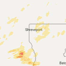
Hail Map for Wednesday, April 26, 2017

Number of Impacted Households on 4/26/2017
0
Impacted by 1" or Larger Hail
0
Impacted by 1.75" or Larger Hail
0
Impacted by 2.5" or Larger Hail
Square Miles of Populated Area Impacted on 4/26/2017
0
Impacted by 1" or Larger Hail
0
Impacted by 1.75" or Larger Hail
0
Impacted by 2.5" or Larger Hail


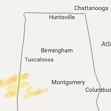


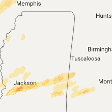


Cities Most Affected by Hail Storms of 4/26/2017
| Hail Size | Demographics of Zip Codes Affected | ||||||
|---|---|---|---|---|---|---|---|
| City | Count | Average | Largest | Pop Density | House Value | Income | Age |
| Lufkin, TX | 3 | 1.75 | 1.75 | 205 | $66k | $34.6k | 34.8 |
| Magazine, AR | 1 | 2.50 | 2.50 | 21 | $44k | $28.0k | 39.6 |
| Brandon, MS | 1 | 2.00 | 2.00 | 369 | $125k | $61.1k | 36.1 |
| Malvern, AR | 1 | 1.75 | 1.75 | 73 | $61k | $31.1k | 39.3 |
| Lebanon, IN | 1 | 1.75 | 1.75 | 125 | $101k | $42.4k | 39.3 |
| Heavener, OK | 1 | 1.75 | 1.75 | 27 | $43k | $25.6k | 32.0 |
| Chester, TX | 1 | 1.75 | 1.75 | 5 | $47k | $40.6k | 43.0 |
| Marion, IN | 1 | 1.75 | 1.75 | 193 | $77k | $37.2k | 44.0 |
| Bay, AR | 1 | 1.75 | 1.75 | 40 | $51k | $31.7k | 36.7 |
| Merryville, LA | 1 | 1.75 | 1.75 | 11 | $52k | $28.4k | 41.2 |
| Kennard, TX | 1 | 1.75 | 1.75 | 5 | $45k | $29.5k | 45.1 |
| Kerens, TX | 1 | 1.75 | 1.75 | 20 | $45k | $29.3k | 44.5 |
Hail and Wind Damage Spotted on 4/26/2017
Filter by Report Type:Hail ReportsWind Reports
States Impacted
Texas, Oklahoma, Arkansas, Missouri, Illinois, Louisiana, Indiana, Kentucky, Mississippi, MichiganTexas
| Local Time | Report Details |
|---|---|
| 7:10 AM CDT | Quarter sized hail reported near Commerce, TX, 61.3 miles ENE of Dallas, TX, quarter size hail reported in southeast commerce |
| 7:15 AM CDT | Ping Pong Ball sized hail reported near Klondike, TX, 70.6 miles ENE of Dallas, TX, ping pong ball size hail reported in klondike fm 1731 (southwest of cooper) |
| 7:15 AM CDT | Quarter sized hail reported near Lancaster, TX, 12.6 miles SSE of Dallas, TX, delayed report: quarter size hail reported in lancaster |
| 12:27 PM CDT | Quarter sized hail reported near Kerens, TX, 55.6 miles SE of Dallas, TX, quarter size hail reported just west of kerens |
| 12:32 PM CDT | Golf Ball sized hail reported near Kerens, TX, 55 miles SE of Dallas, TX, golf ball size hail reported 1 mi n of kerens |
| 1:36 PM CDT | Quarter sized hail reported near Lindale, TX, 83.8 miles ESE of Dallas, TX |
| 1:38 PM CDT | Storm damage reported in smith county TX, 80.8 miles NNW of Lufkin, TX |
| 2:57 PM CDT | Quarter sized hail reported near Longview, TX, 59.2 miles W of Shreveport, LA |
| 3:15 PM CDT | Sheriff department reports trees down across fm road 132 in marion county TX, 40.1 miles WNW of Shreveport, LA |
| 3:22 PM CDT | Quarter sized hail reported near Crockett, TX, 45.1 miles W of Lufkin, TX |
| 3:25 PM CDT | Trees down across county road 214 in rusk county TX, 52.8 miles WSW of Shreveport, LA |
| 3:25 PM CDT | Quarter sized hail reported near Crockett, TX, 43.9 miles W of Lufkin, TX, public reports 1 inch hail in crockett via the ktre-tv facebook page |
| 3:39 PM CDT | Golf Ball sized hail reported near Kennard, TX, 26.8 miles W of Lufkin, TX |
| 3:54 PM CDT | Quarter sized hail reported near Wells, TX, 15.7 miles NW of Lufkin, TX |
| 4:00 PM CDT | Quarter sized hail reported near Pollok, TX, 14.2 miles WNW of Lufkin, TX, public reports quarter size hail via ktre-tv facebook page in the redtown community near pollock. |
| 4:34 PM CDT | Golf Ball sized hail reported near Lufkin, TX, 0.7 miles WSW of Lufkin, TX, public reports golfball size hail via ktre-tv facebook page. |
| 4:45 PM CDT | Golf Ball sized hail reported near Lufkin, TX, 8.1 miles SSE of Lufkin, TX, public reports hail in the bald hill community via ktre facebook page. |
| 4:50 PM CDT | Golf Ball sized hail reported near Lufkin, TX, 12.9 miles SSE of Lufkin, TX, public reports hail at the intersection of fm road 58 and fm road 1818 in the beulah community. |
| 4:55 PM CDT | Quarter sized hail reported near Huntington, TX, 9.2 miles ESE of Lufkin, TX |
| 4:56 PM CDT | Half Dollar sized hail reported near Corrigan, TX, 24.3 miles SSW of Lufkin, TX, public reports half dollar size hail in corrigan via the ktre-tv facebook page. |
| 5:13 PM CDT | Golf Ball sized hail reported near Chester, TX, 29.9 miles SSE of Lufkin, TX |
| 5:15 PM CDT | Quarter sized hail reported near Zavalla, TX, 21.7 miles SE of Lufkin, TX |
| 6:00 PM CDT | Quarter sized hail reported near Woodville, TX, 49.7 miles SE of Lufkin, TX |
| 6:15 PM CDT | Half Dollar sized hail reported near Jasper, TX, 54.4 miles SE of Lufkin, TX, public relayed photos via social media of half dollar sized hail in the springhill community. |
| 6:22 PM CDT | Quarter sized hail reported near Kirbyville, TX, 47.9 miles NNW of Beaumont, TX, public relayed photo via social media of estimated quarter size hail near magnolia springs. |
| 6:25 PM CDT | Quarter sized hail reported near Kirbyville, TX, 47.9 miles NNW of Beaumont, TX, public relayed photo via social media of esitmated quarter size hail near magnolia springs. |
| 6:38 PM CDT | Quarter sized hail reported near Kirbyville, TX, 40.3 miles NNW of Beaumont, TX |
Oklahoma
| Local Time | Report Details |
|---|---|
| 8:12 AM CDT | Golf Ball sized hail reported near Heavener, OK, 35.6 miles SSW of Fort Smith, AR, several vehicles have broken windshields and body damage on the north side of town. |
Arkansas
| Local Time | Report Details |
|---|---|
| 8:57 AM CDT | Quarter sized hail reported near Charleston, AR, 22.3 miles ESE of Fort Smith, AR |
| 9:10 AM CDT | Tennis Ball sized hail reported near Magazine, AR, 32.7 miles ESE of Fort Smith, AR |
| 9:15 AM CDT | Quarter sized hail reported near Ratcliff, AR, 31.7 miles E of Fort Smith, AR, relayed by franklin county oem. time based off radar. |
| 9:24 AM CDT | Quarter sized hail reported near Gamaliel, AR, 78.8 miles SE of Springfield, MO |
| 9:30 AM CDT | Wind damage reported in vidett in fulton county AR, 84.3 miles SE of Springfield, MO |
| 9:33 AM CDT | Tree...powerline...and some roof damage was reporte in fulton county AR, 87.4 miles SSW of Salem, MO |
| 9:40 AM CDT | Quarter sized hail reported near Clarksville, AR, 50.6 miles E of Fort Smith, AR |
| 9:53 AM CDT | Tree was reported down on a house in rove in yell county AR, 64.6 miles ESE of Fort Smith, AR |
| 9:56 AM CDT | Trees reported down throughout danvill in yell county AR, 62.7 miles ESE of Fort Smith, AR |
| 10:08 AM CDT | Several trees reported down in dardanelle in yell county AR, 60.7 miles WNW of Little Rock, AR |
| 10:14 AM CDT | Quarter sized hail reported near Dardanelle, AR, 56.9 miles WNW of Little Rock, AR, mping report. |
| 10:15 AM CDT | Trees reported down in russellvill in pope county AR, 60.8 miles NW of Little Rock, AR |
| 10:22 AM CDT | Trees reported down in atkin in pope county AR, 51.1 miles NW of Little Rock, AR |
| 10:29 AM CDT | Quarter sized hail reported near Atkins, AR, 57.3 miles NW of Little Rock, AR |
| 10:30 AM CDT | Numerous trees reported dow in conway county AR, 44.9 miles NW of Little Rock, AR |
| 10:39 AM CDT | Trees reported to be dow in conway county AR, 48.9 miles NNW of Little Rock, AR |
| 3:05 PM CDT | Golf Ball sized hail reported near Malvern, AR, 35 miles SW of Little Rock, AR |
| 4:23 PM CDT | A spotter measured a 60 mph wind gust...which kicked up alot of dus in prairie county AR, 40.5 miles ESE of Little Rock, AR |
| 4:34 PM CDT | Trees were blown dow in calhoun county AR, 68.5 miles ESE of Nashville, AR |
| 4:43 PM CDT | There was extensive damage to trees and power lines at brinkle in monroe county AR, 62.3 miles E of Little Rock, AR |
| 4:48 PM CDT | Reports of power lines and trees down in southern woodruff county south of county road 30 in woodruff county AR, 60.9 miles ENE of Little Rock, AR |
| 4:48 PM CDT | Quarter sized hail reported near Augusta, AR, 62 miles ENE of Little Rock, AR |
| 4:50 PM CDT | A mobile road sign was blown down on interstate 40 at brinkle in monroe county AR, 62.3 miles E of Little Rock, AR |
| 4:53 PM CDT | Reports of power lines and trees down on highway 26 in woodruff county AR, 65.6 miles W of Memphis, TN |
| 5:02 PM CDT | Powerlines down. time estimated on rada in st. francis county AR, 62.2 miles WSW of Memphis, TN |
| 5:27 PM CDT | Tree down on hwy 311 in st. francis county AR, 42.8 miles W of Memphis, TN |
| 5:32 PM CDT | Trees and powerlines down. damage to one hom in cross county AR, 42.3 miles W of Memphis, TN |
| 5:33 PM CDT | Trees and powerlines down on hwy 46 in poinsett county AR, 44.6 miles NW of Memphis, TN |
| 5:36 PM CDT | Golf Ball sized hail reported near Bay, AR, 49.9 miles NW of Memphis, TN |
Missouri
| Local Time | Report Details |
|---|---|
| 9:15 AM CDT | Quarter sized hail reported near Dora, MO, 66.6 miles ESE of Springfield, MO, quarter size hail near high school. |
| 9:20 AM CDT | Tree down across cr 54 in ozark county MO, 71.3 miles SE of Springfield, MO |
| 9:20 AM CDT | Quarter sized hail reported near Gainesville, MO, 70.5 miles SE of Springfield, MO, quarter size hail and 65mph winds reported via spotter relayed from nws little rock. |
| 9:35 AM CDT | Trees down across roa in ozark county MO, 74.5 miles ESE of Springfield, MO |
| 9:56 AM CDT | Quarter sized hail reported near Pottersville, MO, 70.1 miles SSW of Salem, MO |
| 9:58 AM CDT | Quarter sized hail reported near West Plains, MO, 64.9 miles SSW of Salem, MO |
| 10:00 AM CDT | Power poles blown over in west plain in howell county MO, 64.9 miles SSW of Salem, MO |
| 10:02 AM CDT | Tower fell onto conservation building on east side of west plain in howell county MO, 64.9 miles SSW of Salem, MO |
| 10:03 AM CDT | Trees down at west plains municipal golf cours in howell county MO, 63.4 miles SSW of Salem, MO |
| 10:05 AM CDT | Tree down across state highway z in howell county MO, 65.6 miles SSW of Salem, MO |
| 10:05 AM CDT | Trees down on highway 17 6 miles north of 16 in howell county MO, 55.4 miles SSW of Salem, MO |
| 12:20 PM CDT | Quarter sized hail reported near Annapolis, MO, 49.7 miles ESE of Salem, MO, hail approaching quarter size at the onset of event quickly diminished in size thereafter. |
| 1:08 PM CDT | Flagpole snappe in madison county MO, 45.2 miles WNW of Cape Girardeau, MO |
| 1:51 PM CDT | Storm damage reported in perry county MO, 42.1 miles NNW of Cape Girardeau, MO |
| 6:25 PM CDT | On i-55 mile marker 12.5 several tractor trailers blown off the interstat in pemiscot county MO, 65.8 miles NNE of Memphis, TN |
| 6:45 PM CDT | Several trees down around caruthersville blocking roads. also some power lines dow in pemiscot county MO, 64.4 miles W of Mc Kenzie, TN |
Illinois
| Local Time | Report Details |
|---|---|
| 1:41 PM CDT | Tree on hous in randolph county IL, 45.4 miles NNW of Cape Girardeau, MO |
| 1:47 PM CDT | Storm damage reported in randolph county IL, 45.4 miles NNW of Cape Girardeau, MO |
| 1:50 PM CDT | Several tree limbs down on the north end of town. 4" to 5" diamete in randolph county IL, 45.4 miles NNW of Cape Girardeau, MO |
| 1:53 PM CDT | Several tree limbs down. 3" diamete in randolph county IL, 45.4 miles NNW of Cape Girardeau, MO |
| 2:15 PM CDT | Numerous trees and large limbs down near hwy 15 in perry county IL, 53.7 miles N of Cape Girardeau, MO |
| 3:00 PM CDT | Overturned semi and trailer along highway 154 and central road. fire rescue respondin in franklin county IL, 60.7 miles NNE of Cape Girardeau, MO |
| 3:05 PM CDT | Storm damage reported in jefferson county IL, 72.9 miles ESE of Saint Louis, MO |
| 3:17 PM CDT | Wall cloud with rotation reported with stor in jefferson county IL, 73.1 miles ESE of Saint Louis, MO |
| 3:20 PM CDT | Small hail reported with this stor in jefferson county IL, 72.4 miles WNW of Evansville, IN |
| 3:22 PM CDT | Occurred near jefferson/wayne county line. small limbs dow in jefferson county IL, 68.5 miles WNW of Evansville, IN |
| 3:37 PM CDT | Storm damage reported in clay county IL, 61.4 miles SSW of Mattoon, IL |
| 3:59 PM CDT | Power lines downed at route 45 north at cheetah lane. road is blocke in clay county IL, 40.9 miles S of Mattoon, IL |
| 4:03 PM CDT | With pea sized hail in clay county IL, 54.6 miles S of Mattoon, IL |
| 4:08 PM CDT | Tree downed on traile in clay county IL, 54.6 miles S of Mattoon, IL |
| 4:12 PM CDT | Storm damage reported in richland county IL, 55.6 miles SSE of Mattoon, IL |
| 4:22 PM CDT | Power poles and power lines downed. damage to an outbuilding. 0.50 inch hail covering roadways. time estimated by rada in jasper county IL, 43.6 miles SSE of Mattoon, IL |
| 4:31 PM CDT | Storm damage reported in crawford county IL, 41.6 miles SE of Mattoon, IL |
| 4:33 PM CDT | Damage to roof of a busines in crawford county IL, 41.6 miles SE of Mattoon, IL |
| 4:33 PM CDT | Half Dollar sized hail reported near Oblong, IL, 41.6 miles SE of Mattoon, IL |
| 4:34 PM CDT | Numerous trees reported down on a propert in crawford county IL, 41.6 miles SE of Mattoon, IL |
| 4:38 PM CDT | With 0.50 inch hai in crawford county IL, 41.6 miles SE of Mattoon, IL |
| 4:45 PM CDT | Numerous trees downed. time estimated by rada in clark county IL, 28.3 miles ESE of Mattoon, IL |
| 4:48 PM CDT | Numerous trees downed. time estimated by rada in clark county IL, 41.9 miles ESE of Mattoon, IL |
| 4:55 PM CDT | Robinson airport aso in crawford county IL, 50.3 miles SE of Mattoon, IL |
| 4:58 PM CDT | Numerous trees downed. time estimated by rada in clark county IL, 37.1 miles E of Mattoon, IL |
Louisiana
| Local Time | Report Details |
|---|---|
| 4:00 PM CDT | Public report on ktal facebook page of large tree and utility pole down on colquitt street in bossier cit in bossier county LA, 1.1 miles ENE of Shreveport, LA |
| 4:05 PM CDT | Quarter sized hail reported near Sarepta, LA, 31.7 miles NNE of Shreveport, LA, public reports hail via ksla facebook page. |
| 5:35 PM CDT | Quarter sized hail reported near Castor, LA, 40.4 miles ESE of Shreveport, LA |
| 5:40 PM CDT | Sheriff reports large tree across the road at the intersection of state highway 797 and state highway 14 in lincoln county LA, 50.7 miles E of Shreveport, LA |
| 5:45 PM CDT | Quarter sized hail reported near Bienville, LA, 54.1 miles ESE of Shreveport, LA, public reports quarter size hail around the the lucky and friendship communities via ksla facebook. |
| 5:55 PM CDT | Sheriff repots tree down on hamilton road in dubac in lincoln county LA, 43.7 miles W of Bastrop, LA |
| 6:05 PM CDT | Quarter sized hail reported near Grambling, LA, 49.4 miles WSW of Bastrop, LA |
| 6:15 PM CDT | Quarter sized hail reported near Quitman, LA, 55.5 miles WSW of Bastrop, LA |
| 6:47 PM CDT | Monroe regional airport asos reports gust of 51 kts from the wes in ouachita county LA, 20.2 miles SSW of Bastrop, LA |
| 7:10 PM CDT | Multiple trees downed across richland paris in richland county LA, 21.3 miles SSE of Bastrop, LA |
| 7:15 PM CDT | Several trees down across richland paris in richland county LA, 24 miles SSE of Bastrop, LA |
| 7:19 PM CDT | Golf Ball sized hail reported near Merryville, LA, 31.7 miles NNE of Beaumont, TX, media relayed public report of golfball sized hail near fields. |
| 7:28 PM CDT | Half Dollar sized hail reported near Singer, LA, 34.9 miles NNE of Beaumont, TX, public sent photo via social media of estimated half dollar size hail near oretta. |
Indiana
| Local Time | Report Details |
|---|---|
| 5:59 PM EDT | Quarter sized hail reported near Brazil, IN, 55.5 miles WSW of Indianapolis, IN |
| 6:11 PM EDT | Power was knocked out at a gas station. trash cans were sent flying across the lo in vigo county IN, 54.8 miles ESE of Mattoon, IL |
| 6:35 PM EDT | Multiple trees down across county roads. 231 between greencastle and 40 closed due to multiple trees and power lines down. 1 inch hail reported also. time estimate in putnam county IN, 38.8 miles WSW of Indianapolis, IN |
| 6:56 PM EDT | Half Dollar sized hail reported near Jamestown, IN, 29.9 miles WNW of Indianapolis, IN |
| 7:02 PM EDT | Quarter sized hail reported near Fillmore, IN, 32.7 miles WSW of Indianapolis, IN |
| 7:02 PM EDT | Storm damage reported in putnam county IN, 32.7 miles WSW of Indianapolis, IN |
| 7:08 PM EDT | Golf Ball sized hail reported near Lebanon, IN, 25.9 miles NW of Indianapolis, IN |
| 7:17 PM EDT | Quarter sized hail reported near Danville, IN, 21.8 miles W of Indianapolis, IN |
| 7:36 PM EDT | Wind estimated at 50-60 mp in tipton county IN, 36.3 miles N of Indianapolis, IN |
| 7:36 PM EDT | Half Dollar sized hail reported near Kempton, IN, 36.3 miles N of Indianapolis, IN |
| 7:42 PM EDT | Storm damage reported in tipton county IN, 42.3 miles N of Indianapolis, IN |
| 7:42 PM EDT | Quarter sized hail reported near Sharpsville, IN, 42.3 miles N of Indianapolis, IN |
| 7:50 PM EDT | Half Dollar sized hail reported near Kokomo, IN, 49.2 miles N of Indianapolis, IN, quarter to half dollar sized hail |
| 7:56 PM EDT | Numerous trees down across greentow in howard county IN, 50.2 miles NNE of Indianapolis, IN |
| 7:59 PM EDT | Quarter sized hail reported near Arcadia, IN, 29.5 miles NNE of Indianapolis, IN |
| 8:01 PM EDT | Old barn blown into road - clean up in process as of 8:32 p in howard county IN, 52 miles NNE of Indianapolis, IN |
| 8:13 PM EDT | Storm damage reported in tipton county IN, 35.6 miles NNE of Indianapolis, IN |
| 8:15 PM EDT | Quarter sized hail reported near Frankton, IN, 37.2 miles NNE of Indianapolis, IN |
| 8:15 PM EDT | Quarter sized hail reported near Elwood, IN, 38.3 miles NNE of Indianapolis, IN |
| 8:15 PM EDT | Golf Ball sized hail reported near Marion, IN, 44.8 miles SW of Fort Wayne, IN |
| 8:18 PM EDT | Quarter sized hail reported near Elwood, IN, 39.7 miles NNE of Indianapolis, IN, hail is slightly larger than quarter size. |
| 8:50 PM EDT | Power lines down across road and several power outage in huntington county IN, 16.7 miles WSW of Fort Wayne, IN |
| 8:50 PM EDT | Power lines down across roa in huntington county IN, 37.6 miles SW of Fort Wayne, IN |
| 8:55 PM EDT | 1 foot diameter tree limbs down and pea sized hai in huntington county IN, 24.9 miles WSW of Fort Wayne, IN |
| 9:00 PM EDT | 10 inch healthy tree down across roa in huntington county IN, 22.4 miles SW of Fort Wayne, IN |
| 9:00 PM EDT | Power lines down across roa in huntington county IN, 19 miles SW of Fort Wayne, IN |
| 9:02 PM EDT | Trees down across the roa in huntington county IN, 24.9 miles WSW of Fort Wayne, IN |
| 9:05 PM EDT | Quarter sized hail reported near Marion, IN, 45.4 miles SW of Fort Wayne, IN, hail damage to van and house. |
| 9:19 PM EDT | Estimates 55 mph sustained for at least 2 minute in allen county IN, 4.9 miles NNE of Fort Wayne, IN |
Kentucky
| Local Time | Report Details |
|---|---|
| 7:12 PM CDT | Late report...barn roof blown off near intersection of jeffres road and 924. reported through medi in fulton county KY, 38.7 miles NW of Mc Kenzie, TN |
| 7:17 PM CDT | Late report...house trailer damaged near highway 30 in hickman county KY, 40.1 miles NNW of Mc Kenzie, TN |
| 7:28 PM CDT | Trees uprooted and limbs down along highway 45 between mayfield and wing in graves county KY, 37.1 miles N of Mc Kenzie, TN |
| 7:30 PM CDT | Storm damage reported in graves county KY, 48.1 miles N of Mc Kenzie, TN |
| 7:37 PM CDT | Storm damage reported in graves county KY, 42.5 miles N of Mc Kenzie, TN |
| 7:37 PM CDT | Storm damage reported in mccracken county KY, 51 miles ESE of Cape Girardeau, MO |
| 7:42 PM CDT | Late report...tree on hom in graves county KY, 52.9 miles N of Mc Kenzie, TN |
| 7:53 PM CDT | Late report...downed trees and power lines reported throughout the county. several highways and secondary roads closed or partially closed due to clean up and repair of in livingston county KY, 64.1 miles E of Cape Girardeau, MO |
Mississippi
| Local Time | Report Details |
|---|---|
| 7:45 PM CDT | Several trees down in glen alla in washington county MS, 67.2 miles ENE of Bastrop, LA |
| 8:27 PM CDT | Tree downed across ms highway 46 in warren county MS, 40.3 miles WNW of Jackson, MS |
| 8:37 PM CDT | Large tree downed across ms highway 3... blocking both lane in warren county MS, 38.5 miles WNW of Jackson, MS |
| 8:39 PM CDT | Tree down on i-20 near mile marker in warren county MS, 36.4 miles W of Jackson, MS |
| 8:43 PM CDT | Tree and power lines downed at warriors trail and shannon l in warren county MS, 34.7 miles W of Jackson, MS |
| 8:44 PM CDT | Tree downed on madison s in yazoo county MS, 40.3 miles NNW of Jackson, MS |
| 8:45 PM CDT | Large tree downed at fisher ferry rd and jeff davis r in warren county MS, 39 miles W of Jackson, MS |
| 8:50 PM CDT | Tree downed on old benton r in yazoo county MS, 38.7 miles NNW of Jackson, MS |
| 8:50 PM CDT | Tree downed on graball freerun r in yazoo county MS, 41.8 miles NNW of Jackson, MS |
| 8:54 PM CDT | Two trees downed across ms highway 43 in yazoo county MS, 28 miles NNW of Jackson, MS |
| 9:36 PM CDT | Quarter sized hail reported near Clinton, MS, 10.6 miles W of Jackson, MS, quarter size off clinton raymond rd. report via social media. |
| 9:38 PM CDT | Half Dollar sized hail reported near Clinton, MS, 10.2 miles WNW of Jackson, MS, dime to half dollar size hail in northwest clinton. |
| 9:39 PM CDT | Quarter sized hail reported near Clinton, MS, 10.3 miles NW of Jackson, MS, reported off williamson rd. |
| 9:51 PM CDT | Quarter sized hail reported near Jackson, MS, 1.4 miles SSW of Jackson, MS, reported near i-20 and i-55 interchange. |
| 9:52 PM CDT | Half Dollar sized hail reported near Jackson, MS, 1.9 miles NE of Jackson, MS, quarter to half dollar size hail in east jackson. |
| 9:53 PM CDT | Quarter sized hail reported near Jackson, MS, 0.6 miles S of Jackson, MS, reported at wlbt studios. |
| 9:57 PM CDT | Tree downed across natchez trace parkway near milepost 14 in leake county MS, 44.3 miles NE of Jackson, MS |
| 9:58 PM CDT | Quarter sized hail reported near Jackson, MS, 7.6 miles W of Jackson, MS, quarter size hail reported on mcraven rd. |
| 9:59 PM CDT | Quarter sized hail reported near Pearl, MS, 6.1 miles ENE of Jackson, MS, penny to quarter size hail in nws jackson. |
| 10:00 PM CDT | Quarter sized hail reported near Jackson, MS, 7.9 miles NNE of Jackson, MS, multiple reports of quarter size hail around ridgeland. |
| 10:00 PM CDT | Quarter sized hail reported near Brandon, MS, 9.5 miles NE of Jackson, MS, at barnett bend. |
| 10:00 PM CDT | Quarter sized hail reported near , , 9.9 miles NNE of Jackson, MS, in ridgeland near the reservoir. |
| 10:00 PM CDT | Trees down along hwy 43 nort in attala county MS, 46.5 miles WSW of Starkville, MS |
| 10:01 PM CDT | Trees down along kings r in attala county MS, 44.4 miles WSW of Starkville, MS |
| 10:01 PM CDT | Half Dollar sized hail reported near Brandon, MS, 9.6 miles ENE of Jackson, MS, reported via mping. |
| 10:03 PM CDT | Trees down along hwy 1 in attala county MS, 47.1 miles SW of Starkville, MS |
| 10:05 PM CDT | Half Dollar sized hail reported near Brandon, MS, 9.4 miles E of Jackson, MS, in the crossgates neighborhood. |
| 10:05 PM CDT | Quarter sized hail reported near Brandon, MS, 11.1 miles ENE of Jackson, MS, in the hidden hills neighborhood. |
| 10:09 PM CDT | Quarter sized hail reported near Brandon, MS, 11.7 miles E of Jackson, MS, dime to quarter size hail. |
| 10:09 PM CDT | Hen Egg sized hail reported near Brandon, MS, 16.8 miles ENE of Jackson, MS, picture on twitter of hail that looks to be slightly bigger than a golf ball. report from holly bush rd in rankin county. |
| 10:15 PM CDT | Numerous trees were blown down across the county and some blocked road in leake county MS, 55.1 miles NE of Jackson, MS |
| 10:40 PM CDT | Tree down on stribling road. another tree is down on county road 21 in leake county MS, 55.9 miles ENE of Jackson, MS |
| 10:41 PM CDT | A tree was blown down on county road 402 and another was blown down on county road 210 near the leake county lin in neshoba county MS, 56.4 miles ENE of Jackson, MS |
| 10:55 PM CDT | Trees down throughout scott count in scott county MS, 41.8 miles E of Jackson, MS |
| 11:20 PM CDT | Quarter sized hail reported near Union, MS, 64.3 miles SSW of Starkville, MS, twitter report of 1 inch hail in union. |
| 12:58 AM CDT | Quarter sized hail reported near Stonewall, MS, 81.5 miles E of Jackson, MS, quarter size hail reported by stonewall police department. |
| 1:02 AM CDT | A tree was blown down on highway 11/80 in kewane in lauderdale county MS, 73.5 miles WNW of Camden, AL |
| 1:08 AM CDT | Quarter sized hail reported near Meridian, MS, 84.1 miles W of Camden, AL, multiple reports of nickel/quarter size hail near enterprise/stonewall east towards hwy 45. |
Michigan
| Local Time | Report Details |
|---|---|
| 11:15 PM EDT | Wind gust measured at the howell asos site. power outages reported from livingston co. dispatc in livingston county MI, 30.5 miles SSW of Flint, MI |
| 11:44 PM EDT | Reported power outages in oakland county MI, 13.4 miles SSE of Flint, MI |
Connect with Interactive Hail Maps