

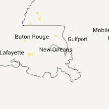
Hail Map for Tuesday, July 5, 2011

Number of Impacted Households on 7/5/2011
0
Impacted by 1" or Larger Hail
0
Impacted by 1.75" or Larger Hail
0
Impacted by 2.5" or Larger Hail
Square Miles of Populated Area Impacted on 7/5/2011
0
Impacted by 1" or Larger Hail
0
Impacted by 1.75" or Larger Hail
0
Impacted by 2.5" or Larger Hail


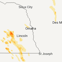


Cities Most Affected by Hail Storms of 7/5/2011
| Hail Size | Demographics of Zip Codes Affected | ||||||
|---|---|---|---|---|---|---|---|
| City | Count | Average | Largest | Pop Density | House Value | Income | Age |
| Newcastle, WY | 2 | 2.75 | 3.00 | 2 | $67k | $32.8k | 42.4 |
| Lexington, NE | 1 | 1.75 | 1.75 | 46 | $64k | $38.3k | 30.8 |
| Hampton, NE | 1 | 1.75 | 1.75 | 8 | $73k | $45.5k | 45.6 |
| Fairmont, NE | 1 | 1.75 | 1.75 | 5 | $41k | $36.3k | 49.9 |
| Oak, NE | 1 | 1.75 | 1.75 | 3 | $10k | $27.5k | 43.5 |
| Aurora, NE | 1 | 1.75 | 1.75 | 30 | $81k | $38.9k | 40.7 |
Hail and Wind Damage Spotted on 7/5/2011
Filter by Report Type:Hail ReportsWind Reports
States Impacted
Arkansas, South Dakota, South Carolina, Iowa, Louisiana, Wisconsin, California, Nebraska, Arizona, Texas, Georgia, North Carolina, Wyoming, Kansas, Montana, ColoradoArkansas
| Local Time | Report Details |
|---|---|
| 3:39 PM UTC | Public reported that a tree was blown down along hwy 16 in independence county AR, 91.1 miles NNE of Little Rock, AR |
| 7:22 PM UTC | Trees and power lines were reported down between mount ida and stor in montgomery county AR, 51.6 miles NNE of Nashville, AR |
| 9:10 PM UTC | Quarter sized hail reported near Nashville, AR, 5.4 miles W of Nashville, AR, tree limbs down and quarter sized hail on yorks chapel road just west of nash |
| 9:15 PM UTC | A few trees were uprooted near nashville. numerous large limbs were downed as wel in howard county AR, 0.6 miles SSW of Nashville, AR |
| 9:15 PM UTC | Quarter sized hail reported near Nashville, AR, 0.6 miles SSW of Nashville, AR, quarter size hail fell in nashville. |
| 10:15 PM UTC | Trees and power lines down on north pine street and large tree down at the intersection of egdewood and third streets in hempstead county AR, 24.2 miles SE of Nashville, AR |
| 10:35 PM UTC | Large limbs down across highway 53 in the bodcaw communit in nevada county AR, 37.1 miles SE of Nashville, AR |
| 10:40 PM UTC | The roof was damaged...brick pillars collapsed...and a stained glass window was shattered at the highland hills baptist church on highway 82 on the east side of texarka in miller county AR, 35.4 miles SSW of Nashville, AR |
| 11:00 PM UTC | Trees down on county road 10 between texarkana and in miller county AR, 44.7 miles S of Nashville, AR |
| 11:20 PM UTC | Large tree down blocking the southbound lane of hwy 53 just south of lewisville in lafayette county AR, 47.9 miles SSE of Nashville, AR |
| 11:25 PM UTC | Large tree down blocking the southbound lane of hwy 53 just south of lewisville in lafayette county AR, 49.8 miles SSE of Nashville, AR |
South Dakota
| Local Time | Report Details |
|---|---|
| 7:05 PM UTC | Quarter sized hail reported near Lead, SD, 35.2 miles WNW of Rapid City, SD |
| 7:40 PM UTC | Half Dollar sized hail reported near Hill City, SD, 27.6 miles W of Rapid City, SD |
| 8:05 PM UTC | Ping Pong Ball sized hail reported near Hill City, SD, 26.7 miles W of Rapid City, SD |
South Carolina
| Local Time | Report Details |
|---|---|
| 8:00 PM UTC | Sc highway patrol reports one tree in the roadway near the intersection of hw-288 and hw-27 in greenville county SC, 15.1 miles NNE of Greenville, SC |
| 8:50 PM UTC | Estimate of 60 to 70 mph winds with nickel size hail in berkeley county SC, 14.2 miles NNE of Charleston, SC |
| 9:00 PM UTC | Quarter sized hail reported near St Stephen, SC, 13.7 miles NNE of Charleston, SC, the public reported quarter size hail near highway 52. |
| 9:03 PM UTC | Thunderstorm winds blew down a tree along drew hill court. time was estimated from rada in colleton county SC, 31.6 miles WSW of Charleston, SC |
| 9:05 PM UTC | Highway patrol reports trees blown down on old williamston rd...on hwy 17 at hwy 86...and power lines down on mountain springs rd...all 2 to 4 wnw of piedmon in anderson county SC, 8 miles SSE of Greenville, SC |
| 9:05 PM UTC | Thunderstorm winds blew down a tree along hughes drive. time was estimated from rada in colleton county SC, 31.8 miles WSW of Charleston, SC |
| 9:08 PM UTC | Sc highway patrol reports one tree in the roadway near the intersection of east mountain creek road and mountain creek church roa in greenville county SC, 14.5 miles ENE of Greenville, SC |
| 9:39 PM UTC | Sc highway patrol reports one tree in the roadway near the intersection of e georgia road and howard driv in greenville county SC, 22 miles ESE of Greenville, SC |
| 10:05 PM UTC | Public reported several large limbs down at the hide-a-way campground on lake marion. on large limb fell down on a campe in orangeburg county SC, 21.8 miles NW of Charleston, SC |
| 10:05 PM UTC | Quarter sized hail reported near Eutawville, SC, 21.8 miles NW of Charleston, SC, public reported quarter size hail at the hide-a-way campground on lake marion. |
| 10:22 PM UTC | Large limbs down across hwy 917 blocking road in dillon county SC, 77.6 miles W of Wilmington, NC |
| 11:56 PM UTC | Sheriff dispatch reported a tree down along hwy 76 just outside of lynchbur in lee county SC, 59 miles N of Charleston, SC |
Iowa
| Local Time | Report Details |
|---|---|
| 8:15 PM UTC | Some two to three inch diameter branches down. from nssl shave projec in kossuth county IA, 55.8 miles W of Mason City, IA |
| 8:22 PM UTC | Listener report relaied via klga. telephone poles down...damage to building...possibily a trailer damaged to in kossuth county IA, 53.6 miles W of Mason City, IA |
| 9:04 PM UTC | Quarter sized hail reported near Burt, IA, 53.2 miles W of Mason City, IA, from nssl shave project. |
| 9:07 PM UTC | Power lines and trees down. from nssl shave projec in kossuth county IA, 53.6 miles W of Mason City, IA |
| 9:12 PM UTC | Maple tree in front yard with limbs broken in half. 8 to 10 inches in diameter. power out. other damage west of burt. from nssl shave projec in kossuth county IA, 54.1 miles W of Mason City, IA |
| 10:19 PM UTC | Tree limbs dow in webster county IA, 53.5 miles E of Storm Lake, IA |
| 10:20 PM UTC | Large limbs down northeast side of fort dodg in webster county IA, 53 miles E of Storm Lake, IA |
| 10:20 PM UTC | Hog building destroyed. trees down. windmill dow in webster county IA, 56.3 miles E of Storm Lake, IA |
| 10:43 PM UTC | Large tree limbs and half a tree down at addresses 2128-2148 320th street. corn partially flattene in webster county IA, 56.3 miles ESE of Storm Lake, IA |
| 11:15 PM UTC | Corn flattened by wind gus in boone county IA, 48.6 miles NNW of Des Moines, IA |
| 12:05 AM UTC | One large 15 inch diameter tree limb blocking one lane. several smaller 4 inch diameter tree limbs dow in dallas county IA, 30.4 miles NW of Des Moines, IA |
Louisiana
| Local Time | Report Details |
|---|---|
| 8:37 PM UTC | Chenault airpark asos reports gust to 58 knots or 67 mp in calcasieu county LA, 36 miles ENE of Beaumont, TX |
Wisconsin
| Local Time | Report Details |
|---|---|
| 9:06 PM UTC | Quarter sized hail reported near Wonewoc, WI, 55 miles NW of Madison, WI, lasted 15 minutes and was 1-2 deep. e1.5 of rain. |
| 9:08 PM UTC | Quarter sized hail reported near Wonewoc, WI, 55 miles NW of Madison, WI, small branches down with winds e50-60 mph. |
| 10:22 PM UTC | Half Dollar sized hail reported near Hayward, WI, 74.9 miles SE of Duluth, MN |
| 10:22 PM UTC | Half Dollar sized hail reported near Hayward, WI, 71.3 miles SE of Duluth, MN, corrected location from previous 10nw winter. |
| 10:24 PM UTC | Trees and powerlines down in three lake in oneida county WI, 16 miles NE of Rhinelander, WI |
| 1:31 AM UTC | Tree down over larson drive near n236 in taylor county WI, 65.9 miles SW of Rhinelander, WI |
| 1:45 AM UTC | Power out and 2-4 inch diameter tree branches down. county line roa in taylor county WI, 76.3 miles WSW of Rhinelander, WI |
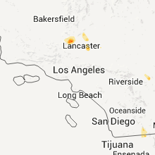
California
| Local Time | Report Details |
|---|---|
| 9:15 PM UTC | Spotter reports damage to awning in joshua tree from tstm wind gust at 215 p in san bernardino county CA, 8.5 miles ENE of Yucca Valley, CA |
| 6:56 AM UTC | Storm damage reported in san bernardino county CA, 25.7 miles NW of Lake Havasu City, AZ |
| 7:08 AM UTC | Storm damage reported in san bernardino county CA, 25.7 miles NW of Lake Havasu City, AZ |
| 7:15 AM UTC | A spotter reported in needles that power was out and transformers were knocked out by the wind. tree branches were also down and shingles were blown off roofs. in addit in san bernardino county CA, 29.1 miles NNW of Lake Havasu City, AZ |
Nebraska
| Local Time | Report Details |
|---|---|
| 9:23 PM UTC | Nickel size hail in polk county NE, 44.9 miles ENE of Grand Island, NE |
| 9:26 PM UTC | Quarter sized hail reported near Osceola, NE, 44.9 miles ENE of Grand Island, NE |
| 9:31 PM UTC | Ping Pong Ball sized hail reported near Osceola, NE, 44.9 miles ENE of Grand Island, NE |
| 9:35 PM UTC | Ping Pong Ball sized hail reported near Osceola, NE, 44.9 miles ENE of Grand Island, NE |
| 9:58 PM UTC | Estimated 60 mile per hour wind with thunderstorm and heavy rain. visibility has been reduced to about a bloc in york county NE, 38.6 miles E of Grand Island, NE |
| 10:15 PM UTC | Estimated wind speeds of 60 to 70 mph around 515 pm. numerous tree limbs up to 6 inches in diamter broke in york county NE, 38.6 miles E of Grand Island, NE |
| 10:20 PM UTC | Estimated wind speeds of 60 to 70 mph around 515 pm. numerous tree limbs up to 6 inches in diamter broke in york county NE, 38.6 miles E of Grand Island, NE |
| 10:25 PM UTC | Half inch als in seward county NE, 52 miles E of Grand Island, NE |
| 10:25 PM UTC | Moderate tree damage in the town of waco. many tree branches down with some a foot in diameter or bigge in york county NE, 46.1 miles E of Grand Island, NE |
| 10:27 PM UTC | Storm damage reported in york county NE, 46.4 miles E of Grand Island, NE |
| 10:34 PM UTC | A large limb fell on garage resulting in roof damag in polk county NE, 44.9 miles ENE of Grand Island, NE |
| 10:40 PM UTC | Quarter sized hail reported near Utica, NE, 53.3 miles E of Grand Island, NE |
| 10:47 PM UTC | Golf Ball sized hail reported near Hampton, NE, 25.2 miles E of Grand Island, NE, quarter to golf ball size hail. |
| 10:53 PM UTC | Quarter sized hail reported near Exeter, NE, 50.6 miles ESE of Grand Island, NE, quarter size hail with 50 to 60 mile per hour winds estimated. |
| 11:00 PM UTC | Measured wind gus in saline county NE, 61.2 miles ESE of Grand Island, NE |
| 11:05 PM UTC | Golf Ball sized hail reported near Aurora, NE, 15.5 miles ESE of Grand Island, NE |
| 11:25 PM UTC | Storm damage reported in saline county NE, 69.5 miles ESE of Grand Island, NE |
| 11:40 PM UTC | Storm damage reported in lancaster county NE, 62.9 miles SW of Omaha, NE |
| 11:44 PM UTC | Measured wind gus in jefferson county NE, 80.1 miles NNW of Manhattan, KS |
| 11:55 PM UTC | Storm damage reported in gage county NE, 78 miles N of Manhattan, KS |
| 11:57 PM UTC | Golf Ball sized hail reported near Fairmont, NE, 43.5 miles ESE of Grand Island, NE |
| 12:00 AM UTC | Golf Ball sized hail reported near Oak, NE, 52.2 miles SSE of Grand Island, NE, golf ball size hail for approximately a 30 minute period. crop damage was reported from oak to ruskin in a 4 mile wide path. |
| 12:03 AM UTC | Quarter sized hail reported near Sutton, NE, 36.1 miles SE of Grand Island, NE, most of the hail was smaller than quarters...but some quarter size hail. rainfall of 0.40 in about 10 minutes. |
| 12:05 AM UTC | Trees blown down blocking roadwa in gage county NE, 75.9 miles N of Manhattan, KS |
| 12:15 AM UTC | Trees and power lines blown down. numerous power outage in gage county NE, 65.2 miles N of Manhattan, KS |
| 12:31 AM UTC | Quarter sized hail reported near Clay Center, NE, 34.9 miles SE of Grand Island, NE |
| 12:37 AM UTC | Quarter sized hail reported near Oak, NE, 56.4 miles SSE of Grand Island, NE, pea to quarter size hail. |
| 12:47 AM UTC | Storm damage reported in pawnee county NE, 65.9 miles N of Manhattan, KS |
| 1:08 AM UTC | Quarter sized hail reported near Chester, NE, 73.6 miles SSE of Grand Island, NE |
| 1:09 AM UTC | Quarter sized hail reported near Chester, NE, 73.6 miles SSE of Grand Island, NE |
| 2:05 AM UTC | Ping Pong Ball sized hail reported near Callaway, NE, 33.5 miles E of North Platte, NE, sparce hail a few ping pong size. |
| 2:31 AM UTC | Quarter sized hail reported near Venango, NE, 58.1 miles NE of Yuma, CO |
| 2:38 AM UTC | Golf Ball sized hail reported near Lexington, NE, 58.6 miles ESE of North Platte, NE, golf ball size hail lasted for approximately 1 to 2 minutes. |
| 2:42 AM UTC | Storm damage reported in dawson county NE, 46.6 miles ESE of North Platte, NE |
| 2:58 AM UTC | 60 to 70 mile per hour winds in overton. very heavy rain and small branches dow in dawson county NE, 64.2 miles W of Grand Island, NE |
| 3:04 AM UTC | Half Dollar sized hail reported near Lexington, NE, 66.2 miles ESE of North Platte, NE |
| 3:19 AM UTC | Ping Pong Ball sized hail reported near Bertrand, NE, 65.2 miles WSW of Grand Island, NE, hail covering the road just south of overton interchange. largest hail size is half dollar to ping pong balls. |
| 3:20 AM UTC | Delayed reports of storm damage from the evening of july 5th. high winds caused tree branches to blow down onto power lines and caused power outages in imperial. large in chase county NE, 62.6 miles SW of North Platte, NE |
| 3:30 AM UTC | Ping Pong Ball sized hail reported near Atlanta, NE, 71.9 miles WSW of Grand Island, NE, hail covering highway 23 between bertrand and loomis. hail size up to ping pong balls. |
| 3:32 AM UTC | Half Dollar sized hail reported near Loomis, NE, 66.8 miles WSW of Grand Island, NE |
| 3:39 AM UTC | Storm damage reported in dundy county NE, 52.2 miles NNW of Colby, KS |
| 3:44 AM UTC | 60 to 70 mile per hour winds with very heavy rainfal in phelps county NE, 66.8 miles WSW of Grand Island, NE |
| 4:10 AM UTC | Coop observer estimated wind gusts up to 70 mph. power is out in imperia in chase county NE, 62.6 miles SW of North Platte, NE |
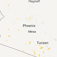
Arizona
| Local Time | Report Details |
|---|---|
| 10:00 PM UTC | From stanton raws station in yavapai county AZ, 62.5 miles NW of Phoenix, AZ |
| 11:58 PM UTC | Davis-monthan asos recorded a 72 mph wind gus in pima county AZ, 2.2 miles NE of Tucson, AZ |
| 11:58 PM UTC | Davis-monthan asos recorded a 77 mph wind gus in pima county AZ, 2.2 miles NE of Tucson, AZ |
| 11:59 PM UTC | Tucson international airport asos recorded a 70 mph wind gus in pima county AZ, 2.2 miles NE of Tucson, AZ |
| 12:01 AM UTC | Spotter reports awning off business at e ajo way and s dodge blv in pima county AZ, 29.7 miles SE of Tucson, AZ |
| 12:10 AM UTC | Storm damage reported in pima county AZ, 2.2 miles NE of Tucson, AZ |
| 12:10 AM UTC | Part of roof blown off and into backyard in pima county AZ, 2.2 miles NE of Tucson, AZ |
| 1:00 AM UTC | Small trees uproote in pima county AZ, 21 miles NW of Tucson, AZ |
| 1:00 AM UTC | Twent foot section of a brick wall blown dow in pima county AZ, 21 miles NW of Tucson, AZ |
| 1:00 AM UTC | Twenty foot section of a brick wall blown dow in pima county AZ, 21 miles NW of Tucson, AZ |
| 1:10 AM UTC | Mesquite tree snapped at the base due to thunderstorm winds. also multiple tree limbs down in the are in pima county AZ, 23 miles WNW of Tucson, AZ |
| 1:10 AM UTC | Several eucalyptus tree limbs dow in pima county AZ, 7 miles NNW of Tucson, AZ |
| 1:45 AM UTC | Tree fell on porch with partial roof damag in pinal county AZ, 45.2 miles SE of Phoenix, AZ |
| 2:20 AM UTC | Several downed trees... along with roof damage... and brick walls blown over in saddlebrook in pinal county AZ, 22.7 miles NNE of Tucson, AZ |
| 2:32 AM UTC | Gilbert and riggs road. several other reports of winds 50 to 65 mp in maricopa county AZ, 22.8 miles SE of Phoenix, AZ |
| 2:40 AM UTC | Two twenty inch trees uprooted and fell on police station at gila river indian communit in pinal county AZ, 32.2 miles SE of Phoenix, AZ |
| 2:40 AM UTC | 20 power polls down in pinal county AZ, 29.4 miles SSE of Phoenix, AZ |
| 2:45 AM UTC | Storm damage reported in maricopa county AZ, 13.5 miles SE of Phoenix, AZ |
| 2:52 AM UTC | Report relayed to nws tree fell on house due to high winds in dust stor in pinal county AZ, 45.2 miles SE of Phoenix, AZ |
| 3:00 AM UTC | Semi truck blown over along interstate 8 at mile marker 16 in pinal county AZ, 45.1 miles SSE of Phoenix, AZ |
| 3:03 AM UTC | Two twenty inch diameter trees fell on police statio in pinal county AZ, 32.2 miles SE of Phoenix, AZ |
| 3:30 AM UTC | Carport collapse. mcclintock and ra in maricopa county AZ, 16.4 miles ESE of Phoenix, AZ |
| 7:30 AM UTC | Thunderstorm winds uprooted two large mesquite trees in rotary community park in lake havasu city. in addition numerous tree limbs were reported down and rough lake wat in mohave county AZ, 1 miles SSE of Lake Havasu City, AZ |
Texas
| Local Time | Report Details |
|---|---|
| 10:26 PM UTC | Trees down in devers in liberty county TX, 50.4 miles ENE of Houston, TX |
| 10:38 PM UTC | 2 metal sheds with roof damage and trees down in houston county TX, 40.3 miles WNW of Lufkin, TX |
| 11:27 PM UTC | Part of the roof of a mobile home in pert was removed. another part of the roof was partially lifted of in anderson county TX, 62.2 miles NW of Lufkin, TX |
| 11:44 PM UTC | Trees were blown down about 10 miles north of palestine along fm 315. one of the trees was 15" in diamete in anderson county TX, 65.7 miles NW of Lufkin, TX |
| 12:25 AM UTC | Large pine tree down across fm 645 roughly 2-3 miles south of tennessee colony in anderson county TX, 73.5 miles WNW of Lufkin, TX |
Georgia
| Local Time | Report Details |
|---|---|
| 10:28 PM UTC | Quarter sized hail reported near Lyons, GA, 57.1 miles NNE of Douglas, GA, also a couple of trees and road signs blown down. |
| 12:10 AM UTC | Several trees and a few power lines down in barrow county GA, 42 miles ENE of Atlanta, GA |
North Carolina
| Local Time | Report Details |
|---|---|
| 10:35 PM UTC | Branches and trees down on mutt griffin road. marble sized hail. relayed from medi in duplin county NC, 49.9 miles NNE of Wilmington, NC |
| 10:40 PM UTC | Power lines down in bladen county NC, 52.6 miles WNW of Wilmington, NC |
| 10:40 PM UTC | A few trees down at intersection of hwy 211 and webb faulk r in bladen county NC, 55.3 miles WNW of Wilmington, NC |
| 11:20 PM UTC | Tree down on lake wheeler road in wake county NC, 11.8 miles SSW of Raleigh, NC |
| 12:17 AM UTC | A few trees down at intersection of hwy 211 and webb faulk r in bladen county NC, 55.3 miles WNW of Wilmington, NC |
| 1:12 AM UTC | One tree fell on a vehicle near highway 581 and renfrow road in wilson county NC, 31.4 miles ESE of Raleigh, NC |
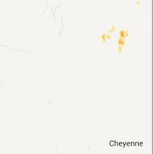
Wyoming
| Local Time | Report Details |
|---|---|
| 11:56 PM UTC | Quarter sized hail reported near Upton, WY, 38 miles SE of Gillette, WY, could hear hail roar to the south. |
| 11:56 PM UTC | Quarter sized hail reported near Newcastle, WY, 56 miles SSE of Gillette, WY, could hear hail roar to the south. |
| 12:38 AM UTC | Tea Cup sized hail reported near Newcastle, WY, 45.3 miles SSE of Gillette, WY |
| 12:38 AM UTC | Tennis Ball sized hail reported near Newcastle, WY, 45.3 miles SSE of Gillette, WY, storm chaser measured 2.5 inch hail stones after the storm passed. event time based on radar signature. |
| 12:57 AM UTC | Quarter sized hail reported near Newcastle, WY, 56 miles SSE of Gillette, WY, dime and quarters. |
| 2:15 AM UTC | Ping Pong Ball sized hail reported near Douglas, WY, 66.8 miles SSE of Gillette, WY, late report. largest stones were up to ping pong ball size. |
| 2:30 AM UTC | Storm damage reported in campbell county WY, 37.5 miles S of Gillette, WY |
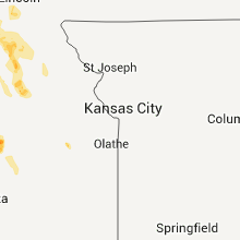
Kansas
| Local Time | Report Details |
|---|---|
| 12:37 AM UTC | Quarter sized hail reported near Marysville, KS, 55.3 miles N of Manhattan, KS |
| 12:37 AM UTC | Storm damage reported in marshall county KS, 55.3 miles N of Manhattan, KS |
| 1:00 AM UTC | Storm damage reported in nemaha county KS, 42.7 miles NE of Manhattan, KS |
| 1:12 AM UTC | Storm damage reported in pottawatomie county KS, 18.5 miles NNW of Manhattan, KS |
| 3:08 AM UTC | Quarter sized hail reported near Hope, KS, 43.4 miles SW of Manhattan, KS |
| 3:13 AM UTC | Half Dollar sized hail reported near Hope, KS, 43.4 miles SW of Manhattan, KS |
| 3:28 AM UTC | Quarter sized hail reported near Ramona, KS, 48.1 miles SW of Manhattan, KS, law enforcement reports quarter sized hail. |
Montana
| Local Time | Report Details |
|---|---|
| 12:40 AM UTC | Ping Pong Ball sized hail reported near Jordan, MT, 36 miles SSE of Glasgow, MT, estimated 1 1/2 inch hail. |
| 12:44 AM UTC | Ping Pong Ball sized hail reported near Fort Peck, MT, 25.2 miles S of Glasgow, MT, estimated 1 1/2 inch hail. measured 0.41 inches of precip. |
| 2:48 AM UTC | Quarter sized hail reported near Cohagen, MT, 63.1 miles SSE of Glasgow, MT, estimated 1 inch hail. measured 0.40 inches precip. still raining lightly. |
| 3:14 AM UTC | Quarter sized hail reported near Roberts, MT, 36 miles SW of Billings, MT, mostly dime to nickel sized...also 0.5 inches of rain |
| 3:16 AM UTC | Quarter sized hail reported near Brockway, MT, 55.5 miles N of Miles City, MT, estimated 1 inch hail. moderate rainfall. still raining. |
Colorado
| Local Time | Report Details |
|---|---|
| 1:33 AM UTC | Storm damage reported in washington county CO, 25.9 miles W of Yuma, CO |
| 3:04 AM UTC | Storm damage reported in yuma county CO, 26.3 miles E of Yuma, CO |
Connect with Interactive Hail Maps