

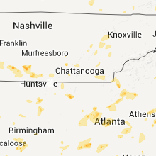
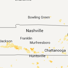
Hail Map for Monday, July 4, 2011

Number of Impacted Households on 7/4/2011
0
Impacted by 1" or Larger Hail
0
Impacted by 1.75" or Larger Hail
0
Impacted by 2.5" or Larger Hail
Square Miles of Populated Area Impacted on 7/4/2011
0
Impacted by 1" or Larger Hail
0
Impacted by 1.75" or Larger Hail
0
Impacted by 2.5" or Larger Hail


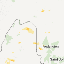


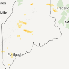


Cities Most Affected by Hail Storms of 7/4/2011
| Hail Size | Demographics of Zip Codes Affected | ||||||
|---|---|---|---|---|---|---|---|
| City | Count | Average | Largest | Pop Density | House Value | Income | Age |
| Euclid, MN | 2 | 1.75 | 1.75 | 3 | $74k | $39.3k | 44.3 |
| Mendenhall, MS | 1 | 2.00 | 2.00 | 52 | $62k | $29.2k | 38.1 |
| Cambridge, ME | 1 | 1.75 | 1.75 | 20 | $54k | $28.5k | 48.3 |
| Vinton, VA | 1 | 1.75 | 1.75 | 411 | $101k | $39.4k | 42.8 |
| Dexter, ME | 1 | 1.75 | 1.75 | 77 | $62k | $27.1k | 45.3 |
| King, NC | 1 | 1.75 | 1.75 | 308 | $100k | $43.9k | 41.1 |
| Amelia Court House, VA | 1 | 1.75 | 1.75 | 39 | $97k | $42.1k | 42.7 |
Hail and Wind Damage Spotted on 7/4/2011
Filter by Report Type:Hail ReportsWind Reports
States Impacted
Kentucky, New Hampshire, Virginia, Maine, Tennessee, West Virginia, North Carolina, Georgia, Alabama, Mississippi, New York, Arkansas, South Carolina, North Dakota, Nevada, Ohio, Oklahoma, Massachusetts, Minnesota, Louisiana, Texas, California, Pennsylvania, Arizona, South Dakota, Colorado, Nebraska, MissouriKentucky
| Local Time | Report Details |
|---|---|
| 4:50 PM UTC | Tree fell on power lines on owens branch roa in perry county KY, 60.6 miles NW of Bristol, TN |
New Hampshire
| Local Time | Report Details |
|---|---|
| 5:15 PM UTC | Trees down on power lines at crystal lake in carroll county NH, 48.5 miles WNW of Portland, ME |
| 5:25 PM UTC | Quarter sized hail reported near Conway, NH, 48.5 miles WNW of Portland, ME, quarter size hail |
| 6:00 PM UTC | Quarter sized hail reported near Eaton, NH, 44.6 miles WNW of Portland, ME, 1 inch hail and large trees down on cove rd along conway lake. |
| 6:00 PM UTC | 1 inch hail and large trees down on cove rd along conway lak in carroll county NH, 44.6 miles WNW of Portland, ME |
| 7:20 PM UTC | Quarter sized hail reported near Windham, NH, 67.6 miles N of Providence, RI |
| 8:00 PM UTC | Trees down in belknap county NH, 60.7 miles WSW of Portland, ME |
| 9:59 PM UTC | Quarter sized hail reported near East Kingston, NH, 63.4 miles SW of Portland, ME |
| 10:05 PM UTC | Quarter sized hail reported near East Kingston, NH, 64.2 miles SW of Portland, ME, east kingston... nh |
| 10:05 PM UTC | Quarter sized hail reported near Kingston, NH, 65.3 miles SW of Portland, ME |
Virginia
| Local Time | Report Details |
|---|---|
| 5:24 PM UTC | Trees are down on lesters fork road in buchanan county VA, 47.9 miles N of Bristol, TN |
| 5:24 PM UTC | Trees down on barebranch road in buchanan county VA, 47.9 miles N of Bristol, TN |
| 5:45 PM UTC | Tree down on state route 684 in grayson county VA, 59.1 miles E of Bristol, TN |
| 5:50 PM UTC | Multiple six inch diameter limbs were blown down at the intersection of routes 58 and 21 in independenc in grayson county VA, 59.6 miles E of Bristol, TN |
| 6:32 PM UTC | Tree down on state route 711 in giles county VA, 46.4 miles W of Roanoke, VA |
| 6:36 PM UTC | One tree down on waidsboro roa in franklin county VA, 24.9 miles S of Roanoke, VA |
| 6:42 PM UTC | Tree down on state route 643 in amherst county VA, 48.8 miles ENE of Roanoke, VA |
| 6:53 PM UTC | Tree down on state route 638 in carroll county VA, 48.8 miles SW of Roanoke, VA |
| 7:00 PM UTC | Tree tops snapped off. estimated wind gust to 65 mp in floyd county VA, 41.5 miles SW of Roanoke, VA |
| 7:00 PM UTC | One tree down on providence church roa in franklin county VA, 24.3 miles S of Roanoke, VA |
| 7:00 PM UTC | Several trees down. 6 inch limbs down in roanoke county VA, 5.5 miles NNW of Roanoke, VA |
| 7:06 PM UTC | Large limbs were blown down in the 5400 block of north lake driv in roanoke county VA, 5.6 miles NW of Roanoke, VA |
| 7:06 PM UTC | A tree was blown down at the intersection of northside high school road and peters creek roa in roanoke county VA, 4.3 miles NW of Roanoke, VA |
| 7:06 PM UTC | A portion of the roof of the northside middle school was blown off. water damage from heavy rain included many ceiling tiles down on the first and second floors and dam in roanoke county VA, 5.2 miles NW of Roanoke, VA |
| 7:07 PM UTC | Storm damage reported in city of roanoke county VA, 3.7 miles NNW of Roanoke, VA |
| 7:07 PM UTC | Thunderstorm winds moved around four to five small airplanes at the roanoke regional airport with at least two damaged. one small plane was flipped over by the wind in city of roanoke county VA, 3.7 miles NNW of Roanoke, VA |
| 7:10 PM UTC | Quarter sized hail reported near Roanoke, VA, 4.8 miles NNW of Roanoke, VA |
| 7:12 PM UTC | At roanoke memorial hospital in city of roanoke county VA, 0.8 miles S of Roanoke, VA |
| 7:12 PM UTC | Storm damage reported in city of roanoke county VA, 1.2 miles WNW of Roanoke, VA |
| 7:12 PM UTC | Storm damage reported in city of roanoke county VA, 3.7 miles NNW of Roanoke, VA |
| 7:12 PM UTC | One tree down on spanish oak roa in franklin county VA, 25.4 miles S of Roanoke, VA |
| 7:15 PM UTC | Tree down on plantation roa in city of roanoke county VA, 2 miles NNE of Roanoke, VA |
| 7:15 PM UTC | One tree down near the intersection of briar mountain and fishburn mountain roa in franklin county VA, 24.4 miles S of Roanoke, VA |
| 7:16 PM UTC | One tree down near valley view mal in city of roanoke county VA, 2.9 miles NNW of Roanoke, VA |
| 7:17 PM UTC | One tree down on franklin stree in franklin county VA, 23.7 miles S of Roanoke, VA |
| 7:17 PM UTC | Tree down on state route 822 in city of roanoke county VA, 2.3 miles NNE of Roanoke, VA |
| 7:19 PM UTC | Storm damage reported in city of roanoke county VA, 3.7 miles NNW of Roanoke, VA |
| 3:20 PM EDT | Golf Ball sized hail reported near Vinton, VA, 6.6 miles E of Roanoke, VA |
| 7:22 PM UTC | Tree down on state route 616 in appomattox county VA, 62.6 miles W of Richmond, VA |
| 7:25 PM UTC | Oak tree down in city of roanoke county VA, 1.2 miles WNW of Roanoke, VA |
| 7:25 PM UTC | Six trees were blown down along jordontown road near hwy 2 in bedford county VA, 8.3 miles E of Roanoke, VA |
| 7:30 PM UTC | Tree down on snake path rd in pittsylvania county VA, 47.9 miles SE of Roanoke, VA |
| 7:31 PM UTC | Tree down on spring garden rd in pittsylvania county VA, 49.1 miles SE of Roanoke, VA |
| 7:45 PM UTC | Trees were blown down in the 6000 block of truman hill roa in franklin county VA, 9.6 miles SE of Roanoke, VA |
| 7:50 PM UTC | Tree down on old richmond rd in pittsylvania county VA, 53.5 miles SE of Roanoke, VA |
| 7:57 PM UTC | Tree down on state route 634 in franklin county VA, 13.1 miles SE of Roanoke, VA |
| 8:08 PM UTC | Tree fell on trailor home in montgomery county VA, 26.6 miles W of Roanoke, VA |
| 8:10 PM UTC | The rockbridge county sheriffs office reported two trees were blown down in the city of lexingto in city of lexington county VA, 44.2 miles NE of Roanoke, VA |
| 8:14 PM UTC | Tree down on state route 658 in charlotte county VA, 60.7 miles WSW of Richmond, VA |
| 8:14 PM UTC | Trees were blown down in the 2500 block of six mile post roa in franklin county VA, 20.3 miles S of Roanoke, VA |
| 8:22 PM UTC | Tree down on snake path rd in pittsylvania county VA, 48.7 miles SE of Roanoke, VA |
| 8:25 PM UTC | Tree down on state route 608 in franklin county VA, 29.2 miles S of Roanoke, VA |
| 8:27 PM UTC | Tree down on us-58 in halifax county VA, 63.7 miles NNW of Raleigh, NC |
| 8:30 PM UTC | Tree down on state route 659 in halifax county VA, 66 miles NNW of Raleigh, NC |
| 8:35 PM UTC | Numerous large tree limbs down at 1068 newton farm road in halifax county VA, 60.6 miles NNW of Raleigh, NC |
| 8:50 PM UTC | Numerous trees blown down all across amherst count in amherst county VA, 53.4 miles ENE of Roanoke, VA |
| 8:51 PM UTC | Tree down onto road 2 miles north of intersection of greenfield road and ennis mountain roa in nelson county VA, 70.5 miles WNW of Richmond, VA |
| 8:51 PM UTC | Tree down onto road at patrick henry highway and tye brook highwa in nelson county VA, 70.5 miles WNW of Richmond, VA |
| 8:53 PM UTC | Tree down onto road near intersection of patrick henry highway and tye brook highwa in nelson county VA, 59.3 miles ENE of Roanoke, VA |
| 8:55 PM UTC | Many trees down in charlotte county VA, 59.2 miles WSW of Richmond, VA |
| 9:09 PM UTC | Tree down on old branchville rd in southampton county VA, 67.4 miles W of Virginia Beach, VA |
| 9:12 PM UTC | Tree down across road at 2988 old roberts mountain road in nelson county VA, 67.1 miles WNW of Richmond, VA |
| 9:15 PM UTC | The pittsylvania county sheriffs office reports multiple trees down in the community of blair in pittsylvania county VA, 51.2 miles SE of Roanoke, VA |
| 9:15 PM UTC | The pittsylvania county sheriffs office reports multiple trees blown down in the community of dry for in pittsylvania county VA, 46.1 miles SE of Roanoke, VA |
| 9:15 PM UTC | Many trees and telephone poles down in charlotte county VA, 57.9 miles SW of Richmond, VA |
| 9:18 PM UTC | Tree down across road near intersection of thomas nelson highway and irish roa in nelson county VA, 64.8 miles WNW of Richmond, VA |
| 9:20 PM UTC | The pittsylvania county sheriffs office reports a tree down in the community of keelin in pittsylvania county VA, 52 miles SE of Roanoke, VA |
| 9:20 PM UTC | Tree across road near intersection of richmond highway and rt 622 in the gladstone are in nelson county VA, 62.9 miles ENE of Roanoke, VA |
| 9:25 PM UTC | Tree down on dodson rd in pittsylvania county VA, 50.4 miles SE of Roanoke, VA |
| 9:35 PM UTC | Tree down on riceville rd in java area in pittsylvania county VA, 49.9 miles ESE of Roanoke, VA |
| 9:39 PM UTC | Tree down on state route 702 in halifax county VA, 52.1 miles ESE of Roanoke, VA |
| 9:45 PM UTC | The buckingham county sheriffs office reports that a tree was blown down along oak hill road near the courthouse area of buckingha in buckingham county VA, 50 miles W of Richmond, VA |
| 9:55 PM UTC | Large tree down at intersection of kiln creek pkwy and brick kiln blv in city of newport ne county VA, 34.7 miles NW of Virginia Beach, VA |
| 10:00 PM UTC | Several trees down in alcom in buckingham county VA, 51.7 miles W of Richmond, VA |
| 10:14 PM UTC | Golf Ball sized hail reported near Amelia Court House, VA, 20.2 miles WSW of Richmond, VA |
| 10:15 PM UTC | Quarter sized hail reported near Fort Lee, VA, 25.9 miles SE of Richmond, VA |
| 10:29 PM UTC | Quarter sized hail reported near Midlothian, VA, 5.9 miles S of Richmond, VA |
| 10:32 PM UTC | Large tree down in cemetry at red lane baptist church in powhatan county VA, 11.1 miles W of Richmond, VA |
| 10:35 PM UTC | 30 foot section of large oak tree top broken of in powhatan county VA, 10.5 miles W of Richmond, VA |
| 10:35 PM UTC | Large tree snapped. residential fence heavily damaged from win in prince george county VA, 25.2 miles SE of Richmond, VA |
| 10:40 PM UTC | Many trees down in the lake shawnee estates section. trees down on powerlines and house in powhatan county VA, 9.6 miles WNW of Richmond, VA |
| 10:45 PM UTC | Trees down in henrico county VA, 18.4 miles ESE of Richmond, VA |
| 10:45 PM UTC | Quarter sized hail reported near Henrico, VA, 18.4 miles ESE of Richmond, VA |
| 10:48 PM UTC | Ping Pong Ball sized hail reported near Henrico, VA, 17 miles ESE of Richmond, VA |
| 11:20 PM UTC | Large tree down blocking both travel lanes on market roa in hanover county VA, 18.2 miles ENE of Richmond, VA |
| 11:28 PM UTC | Large tree down on a house on wisteria plac in city of norfolk county VA, 13.5 miles NNW of Virginia Beach, VA |
Maine
| Local Time | Report Details |
|---|---|
| 5:25 PM UTC | Quarter sized hail reported near Caratunk Plantation, ME, 66.6 miles WNW of Bangor, ME, quarter size hail |
| 6:20 PM UTC | Trees and large branches down across the roads leading to sebec lake. time is estimate in piscataquis county ME, 36.6 miles NNW of Bangor, ME |
| 6:30 PM UTC | Trees down on page avenue in aroostook county ME, 0.1 miles NE of Caribou, ME |
| 6:30 PM UTC | Large tree took down power line on the bondeson road. time is estimate in aroostook county ME, 7.6 miles NW of Caribou, ME |
| 6:30 PM UTC | Golf Ball sized hail reported near Cambridge, ME, 37.5 miles WNW of Bangor, ME, golf ball size hail at cambridge general store |
| 6:35 PM UTC | Tree down across rd in cumberland county ME, 37.6 miles NW of Portland, ME |
| 6:40 PM UTC | Quarter sized hail reported near Norridgewock, ME, 52.3 miles W of Bangor, ME, quarter size hail on winding hill rd |
| 7:03 PM UTC | Golf Ball sized hail reported near Ripley, ME, 32.2 miles WNW of Bangor, ME, golf ball size hail at ellms rd and main st intersection |
| 7:05 PM UTC | Trees and power lines down on st. albans roa in penobscot county ME, 25.4 miles WNW of Bangor, ME |
| 7:05 PM UTC | Half Dollar sized hail reported near Raymond, ME, 19.8 miles NNW of Portland, ME |
| 7:12 PM UTC | Trees and power lines down in corrina cente in penobscot county ME, 25.4 miles WNW of Bangor, ME |
| 7:15 PM UTC | Minor tree damage and estimated 0.25 inch hail in somerset county ME, 53.2 miles WSW of Bangor, ME |
| 7:20 PM UTC | Quarter sized hail reported near Windham, ME, 14.9 miles NW of Portland, ME |
| 7:22 PM UTC | Large trees down in tow in penobscot county ME, 21.5 miles WNW of Bangor, ME |
| 7:27 PM UTC | Trees and power lines down on amsten roa in penobscot county ME, 25.4 miles WNW of Bangor, ME |
| 7:27 PM UTC | Large trees down with power outage in penobscot county ME, 19.1 miles WNW of Bangor, ME |
| 7:29 PM UTC | Estimated 50 to 60 mph winds took down numerous large branches. also received dime size hail. time estimated off rada in kennebec county ME, 51.8 miles WSW of Bangor, ME |
| 7:30 PM UTC | Quarter sized hail reported near Caribou, ME, 0.1 miles NE of Caribou, ME, quarter sized hail. |
| 7:40 PM UTC | Quarter sized hail reported near Levant, ME, 9.6 miles WNW of Bangor, ME |
| 7:40 PM UTC | Large pine trees down on wires in cumberland county ME, 15 miles NNW of Portland, ME |
| 7:40 PM UTC | Large oak down on cars in cumberland county ME, 13.9 miles NW of Portland, ME |
| 7:40 PM UTC | Large oak down on cars in cumberland county ME, 12.2 miles NW of Portland, ME |
| 8:10 PM UTC | Trees and wires down vicinity route 114 and running hill r in cumberland county ME, 6.8 miles W of Portland, ME |
| 8:15 PM UTC | Large tree down in tow in penobscot county ME, 9.6 miles WNW of Bangor, ME |
| 8:21 PM UTC | Trees down rt 114 and saco st in cumberland county ME, 6.3 miles SSW of Portland, ME |
| 8:25 PM UTC | Large limbs on powerlines off broadturn rd in scarboroug in cumberland county ME, 8.6 miles WSW of Portland, ME |
| 8:25 PM UTC | Trees down near holmes rd and den d in cumberland county ME, 7.9 miles WSW of Portland, ME |
| 8:30 PM UTC | Trees down... also hail in york county ME, 33.1 miles SSW of Portland, ME |
| 11:00 PM UTC | Quarter sized hail reported near Monticello, ME, 38.8 miles SSE of Caribou, ME |
Tennessee
| Local Time | Report Details |
|---|---|
| 5:45 PM UTC | Trees and power lines down across northern portions of fayette county. the roof was taken off of a cotton gin along highway 22 in fayette county TN, 39.1 miles ENE of Memphis, TN |
| 6:00 PM UTC | Numerous trees and power lines dow in roane county TN, 35.9 miles W of Knoxville, TN |
| 6:00 PM UTC | Several trees dow in roane county TN, 33.6 miles W of Knoxville, TN |
| 6:50 PM UTC | One tree dow in loudon county TN, 25.9 miles SW of Knoxville, TN |
| 6:50 PM UTC | One tree down on thompson bridge roa in blount county TN, 26.5 miles SSW of Knoxville, TN |
| 7:05 PM UTC | Numerous trees down countywid in carter county TN, 17.4 miles S of Bristol, TN |
| 7:21 PM UTC | Numerous trees down countywide in carter county TN, 21.7 miles S of Bristol, TN |
| 7:55 PM UTC | Decatur county sheriffs office reports several trees down across the southern portions of decatur county...primarily south of highway 10 in decatur county TN, 50.2 miles SSE of Mc Kenzie, TN |
| 8:17 PM UTC | Downed trees and power lines are blocking u.s. hwy 64 west of lawrencebur in lawrence county TN, 35.8 miles NNE of Florence, AL |
| 8:45 PM UTC | Mobile home blown over in lincoln county TN, 67.7 miles ENE of Florence, AL |
| 9:15 PM UTC | Large trees in marshall county TN, 41.4 miles S of Nashville, TN |
| 9:15 PM UTC | Several large trees were in marshall county TN, 46.1 miles S of Nashville, TN |
| 9:25 PM UTC | Public estimated 50-60 mph winds from a thunderstorm. tops of 2 trees broken of in giles county TN, 53.6 miles NE of Florence, AL |
West Virginia
| Local Time | Report Details |
|---|---|
| 5:50 PM UTC | Trees down in the city of raysal in mcdowell county WV, 57.7 miles NNE of Bristol, TN |
| 5:54 PM UTC | Trees down in iaeger in mcdowell county WV, 62.1 miles S of Charleston, WV |
| 6:00 PM UTC | Damage to roofs...porches...and other property in roderfield in mcdowell county WV, 63.6 miles S of Charleston, WV |
| 6:00 PM UTC | Trees down in the town of roderfield in mcdowell county WV, 62.9 miles S of Charleston, WV |
| 6:01 PM UTC | Trees down in marytown in mcdowell county WV, 62.1 miles S of Charleston, WV |
| 6:03 PM UTC | Trees down in the town of davy in mcdowell county WV, 60.7 miles S of Charleston, WV |
| 6:11 PM UTC | The top of an oak tree fell onto a truck in mcdowell county WV, 63.5 miles S of Charleston, WV |
| 6:11 PM UTC | Trees down in welch in mcdowell county WV, 63.5 miles S of Charleston, WV |
| 6:15 PM UTC | Large branches broke in wyoming county WV, 55.1 miles SSE of Charleston, WV |
North Carolina
| Local Time | Report Details |
|---|---|
| 5:55 PM UTC | 1 tree down off clarks chapel r in buncombe county NC, 60.6 miles N of Greenville, SC |
| 5:55 PM UTC | In addition to the previously reported tree across clarks chapel road...other large limbs from other trees were also in the road. crops in the area were bent over to th in buncombe county NC, 60.6 miles N of Greenville, SC |
| 5:55 PM UTC | One tree fell across the road north of north mills river campgroun in henderson county NC, 40.8 miles N of Greenville, SC |
| 5:58 PM UTC | Quarter sized hail reported near Todd, NC, 38.1 miles ESE of Bristol, TN |
| 6:35 PM UTC | A few tree limbs of 2 to 3 inches in diameter fell with the high wind during the storm. did not see any hai in transylvania county NC, 29.8 miles NW of Greenville, SC |
| 7:08 PM UTC | Tree down on jim caudill rd near w. kerr scott reservoir in wilkes county NC, 62.6 miles ESE of Bristol, TN |
| 7:15 PM UTC | Tree down on jess walsh rd near w. kerr scott reservoir in wilkes county NC, 62.7 miles ESE of Bristol, TN |
| 7:28 PM UTC | A few large limbs down in the area around parks driv in burke county NC, 56.6 miles SSE of Bristol, TN |
| 8:00 PM UTC | The surry county sheriffs office reported that a tree was blown down along us hwy 60 in surry county NC, 75.4 miles SW of Roanoke, VA |
| 8:00 PM UTC | 3 trees down in surry county NC, 76.4 miles N of Charlotte, NC |
| 8:07 PM UTC | Numerous trees down in roanoke rapids in halifax county NC, 72 miles NE of Raleigh, NC |
| 8:08 PM UTC | The surry county sheriffs office reported that a tree was blown down into powerlines in the community of rockfor in surry county NC, 73 miles N of Charlotte, NC |
| 8:10 PM UTC | Trees down near windy gap roa in wilkes county NC, 61.6 miles N of Charlotte, NC |
| 8:15 PM UTC | Multiple trees down in orange county NC, 32.3 miles NW of Raleigh, NC |
| 8:15 PM UTC | Tree down in orange county NC, 32.3 miles NW of Raleigh, NC |
| 8:15 PM UTC | Multiple trees down at sams road an oak grove church road in orange county NC, 36.4 miles WNW of Raleigh, NC |
| 8:17 PM UTC | Multiple trees down at mount willing and chestnut ridge church roads in orange county NC, 35.7 miles WNW of Raleigh, NC |
| 8:20 PM UTC | Tree down near buckhorn and chestnut ridge church roads in orange county NC, 35.4 miles WNW of Raleigh, NC |
| 8:20 PM UTC | Trees down near buckhorn and chestnut ridge church roads in orange county NC, 35.4 miles WNW of Raleigh, NC |
| 8:25 PM UTC | One tree down on powerlines at 3031 highland avenu in catawba county NC, 43.2 miles NW of Charlotte, NC |
| 8:30 PM UTC | 3 trees...each 1 foot in diameter...and 1 tree...6 to 8 inches in diameter...blown down in the lake hickory country club area. also large limbs dow in catawba county NC, 45.8 miles NNW of Charlotte, NC |
| 8:35 PM UTC | Trees down near windy gap roa in wilkes county NC, 61.6 miles N of Charlotte, NC |
| 8:36 PM UTC | Quarter sized hail reported near Roaring River, NC, 71.9 miles ESE of Bristol, TN, quarter size hail was observed by austin fire dept volunteers while on byrd |
| 8:40 PM UTC | Tree down on spainhour mill road in forsyth county NC, 73.1 miles NNE of Charlotte, NC |
| 8:41 PM UTC | Tree down near hamilton st in halifax county NC, 72 miles NE of Raleigh, NC |
| 8:41 PM UTC | Tree limbs down ... blocking the road near 10th and oakley in halifax county NC, 71.6 miles NE of Raleigh, NC |
| 8:44 PM UTC | Trees down in vashti community. more in other parts of the count in alexander county NC, 53.9 miles NNW of Charlotte, NC |
| 8:49 PM UTC | Tree down on a shed on woodland road in roanoke rapid in halifax county NC, 72 miles S of Richmond, VA |
| 8:50 PM UTC | Dozen or more trees dow in stokes county NC, 72.2 miles SSW of Roanoke, VA |
| 8:50 PM UTC | One large oak tree down off hwy 274 and flint hill rd just north of cherryvill in gaston county NC, 33 miles WNW of Charlotte, NC |
| 8:50 PM UTC | Golf Ball sized hail reported near King, NC, 72.2 miles SSW of Roanoke, VA |
| 8:55 PM UTC | The stokes county sheriffs office reported a tree blown down in the community of pinnacl in stokes county NC, 69.7 miles SSW of Roanoke, VA |
| 8:55 PM UTC | Tree down near hamilton st in halifax county NC, 72 miles NE of Raleigh, NC |
| 8:56 PM UTC | Tree down near 8th and hamilton st in halifax county NC, 72 miles NE of Raleigh, NC |
| 9:05 PM UTC | Tree down and blocking the roadway near the intersection of furnace road and hw-7 in lincoln county NC, 23.9 miles NW of Charlotte, NC |
| 9:16 PM UTC | Trees down near vienna in forsyth county NC, 67.9 miles NNE of Charlotte, NC |
| 9:20 PM UTC | The stokes county sheriffs office reported a powerpole blown down in the town of germanto in stokes county NC, 70.9 miles SSW of Roanoke, VA |
| 9:20 PM UTC | Power lines down in mount tabor in forsyth county NC, 68.4 miles NNE of Charlotte, NC |
| 9:25 PM UTC | The stokes county sheriffs office reported a tree blown down in walnut cov in stokes county NC, 68.6 miles S of Roanoke, VA |
| 9:30 PM UTC | The stokes county sheriffs office reported a tree blown down along hwy 311 along the stokes and rockingham county lin in stokes county NC, 63.1 miles S of Roanoke, VA |
| 9:30 PM UTC | The rockingham county sheriffs office reports two trees down near the intersection of mizpah church road and jones lake roa in rockingham county NC, 65 miles WNW of Raleigh, NC |
| 9:39 PM UTC | 2 trees down on the road in warren county NC, 50.4 miles NE of Raleigh, NC |
| 9:40 PM UTC | Power lines dow in halifax county NC, 69.9 miles NE of Raleigh, NC |
| 9:40 PM UTC | Tree down on car and power lines on chaloner dr in halifax county NC, 71.1 miles NE of Raleigh, NC |
| 9:40 PM UTC | Quarter sized hail reported near Gastonia, NC, 19.9 miles W of Charlotte, NC, spotter reports dime to quarter size hail at hudson bvd and highway 321. |
| 9:41 PM UTC | Large branches broken in forsyth county NC, 68.7 miles NNE of Charlotte, NC |
| 9:45 PM UTC | Tree down at 813 farmcrest driv in mecklenburg county NC, 2.2 miles ENE of Charlotte, NC |
| 9:45 PM UTC | Numerous trees down in vance county in vance county NC, 42.5 miles NNE of Raleigh, NC |
| 9:47 PM UTC | One tree down at 4718 woodstone driv in mecklenburg county NC, 3.5 miles ENE of Charlotte, NC |
| 9:50 PM UTC | One tree down near the intersection of randolph road and n sharon amity roa in mecklenburg county NC, 3.3 miles SSE of Charlotte, NC |
| 9:55 PM UTC | Trees down near the intersection of old chapel hill road and everwood drive in durham county NC, 21.2 miles WNW of Raleigh, NC |
| 9:55 PM UTC | The rockingham county sheriffs office reports a tree blown down on glencoe church loo in rockingham county NC, 69.9 miles S of Roanoke, VA |
| 10:00 PM UTC | Trees down on upper mountain research statio in rockingham county NC, 63 miles SSE of Roanoke, VA |
| 10:07 PM UTC | Trees and limbs down on powerlines in davidson county NC, 52 miles NE of Charlotte, NC |
| 10:23 PM UTC | Tree down 52 north and south main in new london in stanly county NC, 38.2 miles ENE of Charlotte, NC |
| 10:23 PM UTC | Trees down across easter guilford county in guilford county NC, 58.2 miles WNW of Raleigh, NC |
| 10:23 PM UTC | Trees down across eastern guilford county in guilford county NC, 58.2 miles WNW of Raleigh, NC |
| 10:28 PM UTC | 3 trees down on the bridge in montgomery county NC, 50.2 miles ENE of Charlotte, NC |
| 10:40 PM UTC | Power line down in stanly county NC, 42.2 miles ENE of Charlotte, NC |
| 10:40 PM UTC | Power lines down in stanly county NC, 42.2 miles ENE of Charlotte, NC |
| 10:45 PM UTC | Facade of a sav-a-lot was heavily damage in halifax county NC, 72 miles NE of Raleigh, NC |
| 10:55 PM UTC | Tree down on phone pole in anson county NC, 46.8 miles ESE of Charlotte, NC |
| 10:56 PM UTC | Large pine tree down in a swimming pool near cornwallis road in durham in durham county NC, 22.3 miles NW of Raleigh, NC |
| 11:00 PM UTC | Dozen of trees down across southern portion of county. one power pole down has resulted in power outag in durham county NC, 19.7 miles NW of Raleigh, NC |
| 11:00 PM UTC | Tree down on power pole on lennox drive in anson county NC, 45.8 miles ESE of Charlotte, NC |
| 11:04 PM UTC | Tree on an unoccupied house on highland ave... little damage. likely induced by outflo in montgomery county NC, 47.4 miles E of Charlotte, NC |
| 11:10 PM UTC | Tree down on power pole on lennox drive in anson county NC, 45.8 miles ESE of Charlotte, NC |
Georgia
| Local Time | Report Details |
|---|---|
| 6:30 PM UTC | Trees down countywid in towns county GA, 66.4 miles W of Greenville, SC |
| 7:38 PM UTC | Half Dollar sized hail reported near Comer, GA, 55.8 miles SSW of Greenville, SC, also winds estimated 50-60mph. |
| 8:05 PM UTC | Several trees down just off highway 441 north of mcintyr in wilkinson county GA, 80.2 miles WSW of Augusta, GA |
| 8:28 PM UTC | Quarter sized hail reported near Senoia, GA, 32.2 miles SSW of Atlanta, GA |
| 9:24 PM UTC | Two trees dow in cobb county GA, 16.6 miles NNW of Atlanta, GA |
| 5:30 PM EDT | Several trees down on old highway 76 west of blairsvill in union county GA, 70.7 miles E of Chattanooga, TN |
| 11:30 PM UTC | Three trees down at fire station 19. two fell on the station...one on a vehicl in cherokee county GA, 27.7 miles N of Atlanta, GA |
| 11:30 PM UTC | Three trees down at fire station 19. two fell on the station...one on a vehicl in cherokee county GA, 32.1 miles N of Atlanta, GA |
Alabama
| Local Time | Report Details |
|---|---|
| 6:43 PM UTC | A few trees and large limbs down at brakefield dairy road and highway in walker county AL, 38.4 miles NW of Birmingham, AL |
| 6:51 PM UTC | Quarter sized hail reported near Trussville, AL, 15.2 miles ENE of Birmingham, AL |
| 7:04 PM UTC | Storm damage reported in jefferson county AL, 4.5 miles NE of Birmingham, AL |
| 7:20 PM UTC | Trees down on millwood ln...off hwy 69 southwest of greenboro in hale county AL, 51.1 miles NNW of Camden, AL |
| 8:15 PM UTC | Trees reported down in sumter county AL, 63.6 miles NW of Camden, AL |
| 8:15 PM UTC | Trees down with powerlines damaged...also small hail reported in and north of west blocton in bibb county AL, 32 miles SW of Birmingham, AL |
| 9:05 PM UTC | Multiple trees down in neighborhood along county road 69. one was a large oak tree over 50 feet tall. spotter estimated winds up to 60 mp in shelby county AL, 18.1 miles SSE of Birmingham, AL |
| 9:40 PM UTC | Tree down at 479 thompson falls road near ara in marshall county AL, 58 miles NNE of Birmingham, AL |
| 9:40 PM UTC | Tree down at 479 thompson falls road near arab. time of event is estimated based on radar dat in marshall county AL, 58 miles NNE of Birmingham, AL |
| 9:45 PM UTC | Tree down on elkton rd and elm st in limestone county AL, 40.7 miles E of Florence, AL |
| 9:50 PM UTC | Roof damage to barn on county road 1807 off of 69 in cullman county AL, 55.6 miles NNE of Birmingham, AL |
| 10:42 PM UTC | Tree down on a house at columbus city road in marshall county AL, 65.4 miles SW of Chattanooga, TN |
| 10:48 PM UTC | One tree down along blaylock rd near the state lin in lamar county AL, 46.8 miles NE of Starkville, MS |
Mississippi
| Local Time | Report Details |
|---|---|
| 6:45 PM UTC | 3 trees down across roads and part of the roof of a shed blown of in copiah county MS, 43.2 miles SSW of Jackson, MS |
| 7:02 PM UTC | Damage to outbuilding near highway 84 west. tin was blown into the yard and across highway 84 into the median. power pole was snapped at the botto in jones county MS, 66.1 miles SE of Jackson, MS |
| 7:02 PM UTC | Powerlines down on a tree. power outages in area around highway 407 near poplar cree in montgomery county MS, 45.6 miles W of Starkville, MS |
| 7:20 PM UTC | Reports of trees down on highway 1 in noxubee county MS, 32.7 miles SE of Starkville, MS |
| 7:20 PM UTC | Quarter sized hail reported near Roxie, MS, 75.4 miles SW of Jackson, MS |
| 7:20 PM UTC | Quarter sized hail reported near Laurel, MS, 71.6 miles SE of Jackson, MS, relayed by broadcast media |
| 7:43 PM UTC | Reported trees down on hwy 4 and 30 in tate county MS, 38.2 miles SSE of Memphis, TN |
| 7:47 PM UTC | Quarter sized hail reported near Prentiss, MS, 53.3 miles SSE of Jackson, MS |
| 8:00 PM UTC | Reported trees down on hwy 4 and 30 in tate county MS, 38.2 miles SSE of Memphis, TN |
| 8:06 PM UTC | Quarter sized hail reported near Prentiss, MS, 53.1 miles SSE of Jackson, MS, quarter hail on burkett rd |
| 8:07 PM UTC | Quarter sized hail reported near Prentiss, MS, 52.8 miles SSE of Jackson, MS |
| 8:17 PM UTC | Several trees down in the northern part of lauderdale county. relayed by broadcast medi in lauderdale county MS, 67.3 miles S of Starkville, MS |
| 8:20 PM UTC | Hen Egg sized hail reported near Mendenhall, MS, 29.6 miles SE of Jackson, MS, quarter to hen egg size hail reported in mendenhall. |
| 8:30 PM UTC | Half a metal and wood roof was removed from a shed. a power line was also down with a couple tree in neshoba county MS, 54.9 miles ENE of Jackson, MS |
| 8:50 PM UTC | Multiple trees down across the s portion of the county with a few down on percy bates r in jefferson davis county MS, 61.7 miles SSE of Jackson, MS |
| 9:20 PM UTC | Trees were downed in the city of morto in scott county MS, 30.7 miles E of Jackson, MS |
| 9:30 PM UTC | Quarter sized hail reported near Mantachie, MS, 55.3 miles SW of Florence, AL, nickel to quarter size hail reported. |
| 9:35 PM UTC | Several trees were downed between morton and branch...including the area along ms highway 48 in scott county MS, 29.9 miles ENE of Jackson, MS |
| 9:42 PM UTC | A few trees and power lines down across southeast pontotoc count in chickasaw county MS, 41.9 miles N of Starkville, MS |
| 9:43 PM UTC | Some tin was torn off a roof and some trees were down along evans r in leake county MS, 48.5 miles NE of Jackson, MS |
| 9:49 PM UTC | Wind gust on wdam skycam on top of forrest general hospital in central hattiesbur in forrest county MS, 85.2 miles SE of Jackson, MS |
| 9:56 PM UTC | Half Dollar sized hail reported near Hattiesburg, MS, 85.2 miles SE of Jackson, MS, quarter to half dollar size hail reported. |
| 9:56 PM UTC | A large traffic signal at broadway drive and timothy lane was blown dow in forrest county MS, 85.2 miles SE of Jackson, MS |
| 9:56 PM UTC | Glass front of a building was blown out on highway 49 along with numerous trees and powerlines dow in forrest county MS, 85.2 miles SE of Jackson, MS |
| 9:56 PM UTC | Numerous trees down in the forrest general hospital are in forrest county MS, 85.2 miles SE of Jackson, MS |
| 9:56 PM UTC | Reports of trees down at hardy and 31st street as well as 28th avenue and lee circle in hattiesbur in forrest county MS, 85.2 miles SE of Jackson, MS |
| 9:56 PM UTC | Reports of trees down at hardy and 31st street as well as 28th avenue in hattiesbur in forrest county MS, 85.2 miles SE of Jackson, MS |
| 9:56 PM UTC | Reported power lines down on south side of fulto in itawamba county MS, 56.1 miles SW of Florence, AL |
| 10:05 PM UTC | Reported trees down between shannon and nettleton near shannon primary schoo in lee county MS, 45 miles N of Starkville, MS |
| 10:25 PM UTC | Trees were downed along whiddon rd in madison county MS, 29.4 miles NE of Jackson, MS |
| 10:45 PM UTC | Trees and power lines reported down 5 miles west of splung in monroe county MS, 43.4 miles NE of Starkville, MS |
| 11:15 PM UTC | Lines were downed between benton and midway in yazoo county MS, 36.8 miles N of Jackson, MS |
| 11:25 PM UTC | Trees downed...tree across road at highway 16 and linwood r in yazoo county MS, 31.2 miles N of Jackson, MS |
| 11:50 PM UTC | A few trees down...one down along thornton-tolarville roa in holmes county MS, 54.2 miles N of Jackson, MS |
| 11:50 PM UTC | A few trees and large limbs were blown down around the mileston community in holmes county MS, 56.1 miles N of Jackson, MS |
| 11:59 PM UTC | Half Dollar sized hail reported near Leakesville, MS, 43.9 miles NW of Mobile, AL, greene county ema reported quarter to half dollar size hail in leakesville. |
| 12:15 AM UTC | Trees were downed around mayersville in issaquena county MS, 51.6 miles E of Bastrop, LA |
| 12:30 AM UTC | Powerlines down on north 3rd street in rolling fork in sharkey county MS, 58.6 miles NW of Jackson, MS |
| 12:40 AM UTC | A few trees down east of anguill in sharkey county MS, 58 miles NW of Jackson, MS |
| 1:15 AM UTC | Trees and power lines were downed along dixie farm r in yazoo county MS, 38.8 miles NW of Jackson, MS |
New York
| Local Time | Report Details |
|---|---|
| 6:45 PM UTC | Quarter sized hail reported near Dresden, NY, 59.6 miles SSW of Burlington, VT, 2 trees down and possible window damage to boats. |
Arkansas
| Local Time | Report Details |
|---|---|
| 7:03 PM UTC | Storm damage reported in clark county AR, 34.3 miles NE of Nashville, AR |
| 7:03 PM UTC | Quarter sized hail reported near Amity, AR, 34.3 miles NE of Nashville, AR |
| 7:20 PM UTC | Estimated 50-60 mph winds have blown down several small tree in hot spring county AR, 40 miles NE of Nashville, AR |
| 7:25 PM UTC | Quarter sized hail reported near Mena, AR, 49.1 miles S of Fort Smith, AR |
| 7:52 PM UTC | Trees were reported down in arkadelphi in clark county AR, 46.1 miles ENE of Nashville, AR |
| 7:54 PM UTC | Trees down between caddo valley and arkadelphi in clark county AR, 46.5 miles ENE of Nashville, AR |
| 8:40 PM UTC | Trees were blown dow in cleveland county AR, 51.5 miles SSE of Little Rock, AR |
| 8:55 PM UTC | Tree limbs and power lines were blown dow in hot spring county AR, 40.6 miles SW of Little Rock, AR |
| 9:30 PM UTC | Several large tree limbs were blown down in duma in desha county AR, 74.8 miles SE of Little Rock, AR |
| 10:15 PM UTC | A couple trees were downed along ashley rd 271 in ashley county AR, 18.7 miles NNE of Bastrop, LA |
| 10:45 PM UTC | Power lines and poles down along hwy 82 w near s in union county AR, 34.5 miles NW of Bastrop, LA |
South Carolina
| Local Time | Report Details |
|---|---|
| 8:00 PM UTC | Trees and limbs down. others in little river and sawmill communitie in caldwell county SC, 55.5 miles SE of Bristol, TN |
| 8:05 PM UTC | Highway patrol reports a tree blown down on highway 29 near the state lin in anderson county SC, 35.5 miles SSW of Greenville, SC |
| 8:15 PM UTC | Highway patrol reports a tree down on good hope church rd near highway 8 in anderson county SC, 34.1 miles S of Greenville, SC |
| 8:18 PM UTC | Trees and large limbs down off woods farm rd se of chesne in cherokee county SC, 48.8 miles ENE of Greenville, SC |
| 8:20 PM UTC | Tree down and blocking the roadway at the intersection of swofford ridge road and green lake roa in spartanburg county SC, 47.6 miles ENE of Greenville, SC |
| 8:20 PM UTC | Quarter sized hail reported near Cowpens, SC, 47.3 miles ENE of Greenville, SC |
| 8:58 PM UTC | Highway patrol reported one tree down on mt zion rd and another down on california ave- 3 nnw of spartanburg around 510 p in spartanburg county SC, 31.1 miles ENE of Greenville, SC |
| 9:04 PM UTC | Multiple limbs down off hwy 198 and rock springs rd just north of i-85. limbs were approx 5 to 6 inches in diamete in cherokee county SC, 38.9 miles W of Charlotte, NC |
| 9:06 PM UTC | 2 trees down along hwy 247 near the saluda rive in anderson county SC, 19.8 miles SSE of Greenville, SC |
| 9:30 PM UTC | At least 3 trees down off hwy 76 and georgia rd west of lauren in laurens county SC, 37.4 miles SE of Greenville, SC |
| 9:32 PM UTC | Tree in the roadway at eichelberger road and trinity church roa in laurens county SC, 37.1 miles SE of Greenville, SC |
| 9:34 PM UTC | Highway patrol reported a tree down on fernwood glendale rd. another tree was down on whitestone glendale rd 5 e of spartanbur in spartanburg county SC, 43.1 miles ENE of Greenville, SC |
| 9:36 PM UTC | Tree in the roadway at hw-221 south near the hw-39 split headed towards waterlo in laurens county SC, 39.2 miles SE of Greenville, SC |
| 9:45 PM UTC | Highway patrol reports a tree down on racetrack rd and another on harris bridge rd in the same are in spartanburg county SC, 33.7 miles ESE of Greenville, SC |
| 9:57 PM UTC | Tree in the roadway at harris bridge road and west georgia roa in spartanburg county SC, 32.6 miles ESE of Greenville, SC |
| 10:06 PM UTC | Quarter sized hail reported near Rock Hill, SC, 23.7 miles SSW of Charlotte, NC, 1 inch hail se of rock hill. |
| 10:14 PM UTC | 3 large trees down off hwy 211 and 18 just north of the asbury-reboboth vf in cherokee county SC, 49.7 miles WSW of Charlotte, NC |
| 10:43 PM UTC | Tree down i-77 north bound lane near mile marker 6 in chester county SC, 31.8 miles SSW of Charlotte, NC |
North Dakota
| Local Time | Report Details |
|---|---|
| 8:30 PM UTC | Quarter sized hail reported near Rocklake, ND, 50.2 miles NNW of Devils Lake, ND, penny to quarter size hail fell in rocklake. |
| 9:20 PM UTC | Quarter sized hail reported near Munich, ND, 34.4 miles NNE of Devils Lake, ND, pea to quarter size hail. |
| 9:40 PM UTC | Half Dollar sized hail reported near Neche, ND, 77.6 miles W of Roseau, MN, quarter to half dollar size hail. |
| 9:55 PM UTC | Quarter sized hail reported near Pembina, ND, 68 miles W of Roseau, MN |
| 10:00 PM UTC | Storm damage reported in pembina county ND, 68 miles W of Roseau, MN |
| 10:00 PM UTC | Tree branches of at least 4 inches in diameter are dow in pembina county ND, 68 miles W of Roseau, MN |
| 3:30 AM UTC | Quarter sized hail reported near Leonard, ND, 25.2 miles SW of Fargo, ND, a few dime to quarter sized hail in brief heavy rain. |
Nevada
| Local Time | Report Details |
|---|---|
| 8:30 PM UTC | Storm damage reported in nye county NV, 63.3 miles NW of Las Vegas, NV |
| 9:00 PM UTC | Storm damage reported in nye county NV, 67.5 miles NW of Las Vegas, NV |
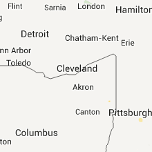
Ohio
| Local Time | Report Details |
|---|---|
| 9:25 PM UTC | Quarter sized hail reported near Leetonia, OH, 48.7 miles NW of Pittsburgh, PA |
| 9:30 PM UTC | Large trees blown dow in columbiana county OH, 47.9 miles NW of Pittsburgh, PA |
| 9:50 PM UTC | Large trees blown dow in columbiana county OH, 42 miles NW of Pittsburgh, PA |
| 9:50 PM UTC | Large trees blown dow in columbiana county OH, 44.2 miles NW of Pittsburgh, PA |
Oklahoma
| Local Time | Report Details |
|---|---|
| 9:40 PM UTC | Roof damage to a restaurant near southwest 15th and agnew. time estimate in oklahoma county OK, 2.3 miles SW of Oklahoma City, OK |
| 9:45 PM UTC | Measured at el reno regional airport /krqo/. time of gust is corrected from the 2155z krqo observation that was determined to be 10 minutes too fas in canadian county OK, 27.6 miles W of Oklahoma City, OK |
| 9:50 PM UTC | Roof damage to an apartment near southwest 29th and portland. time estimate in oklahoma county OK, 4.4 miles SW of Oklahoma City, OK |
| 1:05 AM UTC | Reported by the mill creek emerg mgr. most of the town is without electricity in johnston county OK, 39.6 miles W of Atoka, OK |
| 1:25 AM UTC | Large trees and tree limbs downed across roads and power in johnston county OK, 37.5 miles WSW of Atoka, OK |
| 2:00 AM UTC | Large trees and tree limbs downed across roads and power in johnston county OK, 37.5 miles WSW of Atoka, OK |
| 2:00 AM UTC | 4-6 inch diameter elm tree limbs blown down by strong wind in johnston county OK, 34.1 miles WSW of Atoka, OK |
Massachusetts
| Local Time | Report Details |
|---|---|
| 10:05 PM UTC | Tree down on wires on friend st in essex county MA, 64.8 miles SSW of Portland, ME |
| 10:07 PM UTC | Tree down on whitehall roa in essex county MA, 64.8 miles SSW of Portland, ME |
| 10:15 PM UTC | Quarter sized hail reported near Salisbury, MA, 64.4 miles SSW of Portland, ME |
| 10:15 PM UTC | Several large limbs down at roosevelt place in essex county MA, 66.8 miles SSW of Portland, ME |
| 10:15 PM UTC | Tree down on wire at intersection of forester and merimack street in essex county MA, 66.8 miles SSW of Portland, ME |
| 10:26 PM UTC | Tree down blocking roa in essex county MA, 68.8 miles NNE of Providence, RI |
| 11:05 PM UTC | Large tree down on wheeler st in essex county MA, 67.4 miles NE of Providence, RI |
Minnesota
| Local Time | Report Details |
|---|---|
| 10:07 PM UTC | Reported by canadian meteorological servic in kittson county MN, 67 miles W of Roseau, MN |
| 10:34 PM UTC | Quarter sized hail reported near Lancaster, MN, 53.7 miles W of Roseau, MN, nickel to quarter size hail reported. |
| 11:00 PM UTC | Quarter sized hail reported near Greenbush, MN, 18.9 miles W of Roseau, MN |
| 11:05 PM UTC | Quarter sized hail reported near Hallock, MN, 47.8 miles W of Roseau, MN |
| 11:17 PM UTC | Quarter sized hail reported near Halma, MN, 40.9 miles WSW of Roseau, MN |
| 11:18 PM UTC | Trees of 1 to 2 feet in diameter and 60 to 70 feet in height were snappe in roseau county MN, 12.3 miles WSW of Roseau, MN |
| 11:31 PM UTC | Ping Pong Ball sized hail reported near Warren, MN, 64 miles SW of Roseau, MN |
| 11:45 PM UTC | Trees up to 8 inches in diamter were uprooted and snappe in roseau county MN, 12.8 miles S of Roseau, MN |
| 11:47 PM UTC | Trees of 10 to 12 inches in diameter were snappe in roseau county MN, 12.9 miles S of Roseau, MN |
| 12:17 AM UTC | Golf Ball sized hail reported near Euclid, MN, 69.8 miles SSW of Roseau, MN |
| 12:19 AM UTC | Quarter sized hail reported near Euclid, MN, 73.2 miles SSW of Roseau, MN |
| 12:25 AM UTC | Golf Ball sized hail reported near Euclid, MN, 72 miles SSW of Roseau, MN |
| 1:05 AM UTC | Half Dollar sized hail reported near Crookston, MN, 67.6 miles NNE of Fargo, ND, hail fell in drifts across a farmyard...and left divits completely covering cedar decking. |
| 1:19 AM UTC | Quarter sized hail reported near Nielsville, MN, 45.2 miles N of Fargo, ND |
| 1:45 AM UTC | Report of power lines down near the intersection of hwy. 53 and county road 33 in koochiching county MN, 3.6 miles SE of International Falls, MN |
| 1:51 AM UTC | Half Dollar sized hail reported near Shelly, MN, 41.8 miles N of Fargo, ND, several quarter to half dollar size hail. |
| 1:55 AM UTC | Ping Pong Ball sized hail reported near Shelly, MN, 42.4 miles N of Fargo, ND |
| 2:30 AM UTC | Delayed report from 4th of july. several trees across jansen rd just north of gheen. power was out for 12 hr in st. louis county MN, 51.6 miles SSE of International Falls, MN |
| 2:35 AM UTC | Tree blown down near ball club lake. also some tree branches blown down around inge in itasca county MN, 41.7 miles E of Bemidji, MN |
| 3:45 AM UTC | Winds estimated at 50 to 60 mp in clay county MN, 25.8 miles SE of Fargo, ND |
| 4:07 AM UTC | Measured at the mndot rwis site along interstate 9 in wilkin county MN, 34.6 miles SE of Fargo, ND |
| 6:00 AM UTC | Powerlines down with power out to part of tow in big stone county MN, 43.5 miles NW of Montevideo, MN |
Louisiana
| Local Time | Report Details |
|---|---|
| 10:30 PM UTC | Trees were downed and a roof was blown off a mobile hom in morehouse county LA, 10 miles NNE of Bastrop, LA |
| 10:30 PM UTC | Trees were downed around beekman in morehouse county LA, 10 miles NNE of Bastrop, LA |
| 10:55 PM UTC | Trees were downed around beekman in morehouse county LA, 10 miles NNE of Bastrop, LA |
| 11:25 PM UTC | Reports of a few trees down on highway 14 in morehouse county LA, 8.4 miles NE of Bastrop, LA |
| 11:50 PM UTC | Power lines down on flowers road and large trees down on airline road and holder road in d in lincoln county LA, 43.7 miles W of Bastrop, LA |
| 11:50 PM UTC | House struck by lightning and caught fire on girl scout road in sim in lincoln county LA, 53.2 miles WSW of Bastrop, LA |
| 12:00 AM UTC | Trees down along hwy 15 northeast of farmer in union county LA, 27.1 miles W of Bastrop, LA |
| 12:05 AM UTC | Numerous trees down in northern webster parish just east of sprin in webster county LA, 40.3 miles NE of Shreveport, LA |
Texas
| Local Time | Report Details |
|---|---|
| 11:15 PM UTC | Medium sized trees were knocked down along fm in hopkins county TX, 79 miles ENE of Dallas, TX |
| 12:00 AM UTC | Trees down on macedonia road 4 miles northwest of mar in harrison county TX, 38.4 miles W of Shreveport, LA |
| 12:15 AM UTC | Tin roofs torn off buildings and trees down along county road 3310 near mount v in franklin county TX, 95.4 miles ENE of Dallas, TX |
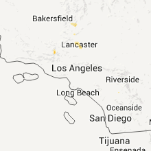
California
| Local Time | Report Details |
|---|---|
| 11:15 PM UTC | Quarter sized hail reported near Lancaster, CA, 48.9 miles SE of Bakersfield, CA, time of occurrence was approximately 400 pm pdt. |
Pennsylvania
| Local Time | Report Details |
|---|---|
| 11:27 PM UTC | Large trees blown down... blocking washington blvd near highland par in allegheny county PA, 4.4 miles ENE of Pittsburgh, PA |
| 11:27 PM UTC | Large trees blown down... blocking washington blvd near highland par in allegheny county PA, 5 miles NE of Pittsburgh, PA |
| 11:27 PM UTC | Large trees blown down... blocking washington blvd near highland par in allegheny county PA, 5.8 miles NE of Pittsburgh, PA |
| 11:27 PM UTC | Large trees blown down... blocking washington blvd near highland par in allegheny county PA, 5 miles NE of Pittsburgh, PA |
Arizona
| Local Time | Report Details |
|---|---|
| 11:30 PM UTC | Local tv news media reported a large tree downed on a car at broadway and craycrof in pima county AZ, 2.2 miles NE of Tucson, AZ |
| 11:45 PM UTC | Local tv news media reported a large tree down on an apartment complex at st. marys and interstate 1 in pima county AZ, 2.2 miles NE of Tucson, AZ |
| 12:00 AM UTC | Tree blown down along with flat roof blown off in pima county AZ, 12.3 miles E of Tucson, AZ |
| 12:10 AM UTC | Local tv news media reported downed power lines at oracle and hard in pima county AZ, 13.7 miles N of Tucson, AZ |
| 12:15 AM UTC | Power lines down park and broadway reported by local tv weathercaster in pima county AZ, 2.2 miles NE of Tucson, AZ |
| 12:15 AM UTC | 2 trees blown down. time estimated off radar in pima county AZ, 19.1 miles ESE of Tucson, AZ |
| 12:20 AM UTC | Roof blown off a manufactured home...100 yrds nw from the spotters hom in pima county AZ, 5.7 miles SSW of Tucson, AZ |
| 1:51 AM UTC | Wind gust from mesonet site in yavapai county AZ, 38.1 miles SW of Flagstaff, AZ |
| 2:15 AM UTC | Large tree blown down into power lines. power lines downe in pinal county AZ, 47.1 miles SSE of Phoenix, AZ |
South Dakota
| Local Time | Report Details |
|---|---|
| 12:55 AM UTC | Storm damage reported in fall river county SD, 52 miles SSW of Rapid City, SD |
| 2:21 AM UTC | Quarter sized hail reported near Westport, SD, 22.9 miles NW of Aberdeen, SD |
| 2:32 AM UTC | Quarter sized hail reported near Westport, SD, 18.6 miles NW of Aberdeen, SD, most of the hail was smaller than quarters |
| 3:03 AM UTC | Quarter sized hail reported near Westport, SD, 16.5 miles NW of Aberdeen, SD |
| 3:20 AM UTC | Quarter sized hail reported near White River, SD, 50.5 miles NNW of Valentine, NE, lasted about 15 minutes |
| 3:30 AM UTC | Quarter sized hail reported near Winner, SD, 21.6 miles NE of Valentine, NE |
| 3:45 AM UTC | Quarter sized hail reported near Aberdeen, SD, 4.9 miles N of Aberdeen, SD |
| 3:53 AM UTC | Storm damage reported in todd county SD, 35.1 miles NNE of Valentine, NE |
| 4:10 AM UTC | Power lines down and tree damage on east shore drive in brown county SD, 8.2 miles NW of Aberdeen, SD |
| 4:15 AM UTC | Quarter sized hail reported near Aberdeen, SD, 0.8 miles NNE of Aberdeen, SD |
| 4:22 AM UTC | Quarter sized hail reported near Aberdeen, SD, 0.8 miles NNE of Aberdeen, SD |
| 4:30 AM UTC | Winds estimated at speeds greater than 60 mph. three inch diameter branches broken from live tree in tripp county SD, 54.1 miles SSE of Pierre, SD |
| 5:30 AM UTC | Several 6 to 8 inch tree branches down in jones county SD, 47.6 miles SSW of Pierre, SD |
| 5:30 AM UTC | Several 6 to 8 inch tree branches down in mellette county SD, 48.3 miles SSW of Pierre, SD |
| 5:48 AM UTC | Quarter sized hail reported near Aberdeen, SD, 5.5 miles NW of Aberdeen, SD |
| 6:00 AM UTC | Transformer blown out by lightning strik in potter county SD, 47.4 miles NNE of Pierre, SD |
| 6:00 AM UTC | Gazebo blown in roberts county SD, 55.9 miles NW of Montevideo, MN |
| 6:00 AM UTC | Roof blown off of trailer house in brown county SD, 0.6 miles W of Aberdeen, SD |
Colorado
| Local Time | Report Details |
|---|---|
| 1:43 AM UTC | Outflow winds from collapsing storm south of site in garfield county CO, 56.1 miles NE of Grand Junction, CO |
Nebraska
| Local Time | Report Details |
|---|---|
| 1:53 AM UTC | Quarter sized hail reported near Ellsworth, NE, 83.5 miles ENE of Scottsbluff, NE |
| 1:53 AM UTC | Quarter sized hail reported near Lakeside, NE, 86.5 miles WSW of Valentine, NE |
| 3:05 AM UTC | Storm damage reported in hooker county NE, 62.7 miles SSW of Valentine, NE |
| 3:15 AM UTC | 60 mph wind gusts lasted from 1005 cdt to 1015 cdt along with pea size hai in hooker county NE, 62.7 miles SSW of Valentine, NE |
Missouri
| Local Time | Report Details |
|---|---|
| 4:28 AM UTC | 1 large tree dow in douglas county MO, 39.2 miles ESE of Springfield, MO |
Connect with Interactive Hail Maps