

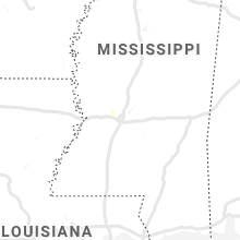
Hail Map for Monday, June 17, 2019

Number of Impacted Households on 6/17/2019
0
Impacted by 1" or Larger Hail
0
Impacted by 1.75" or Larger Hail
0
Impacted by 2.5" or Larger Hail
Square Miles of Populated Area Impacted on 6/17/2019
0
Impacted by 1" or Larger Hail
0
Impacted by 1.75" or Larger Hail
0
Impacted by 2.5" or Larger Hail


Cities Most Affected by Hail Storms of 6/17/2019
| Hail Size | Demographics of Zip Codes Affected | ||||||
|---|---|---|---|---|---|---|---|
| City | Count | Average | Largest | Pop Density | House Value | Income | Age |
| Fort Davis, TX | 3 | 1.92 | 2.00 | 1 | $76k | $31.6k | 52.1 |
| Leonardtown, MD | 2 | 1.75 | 1.75 | 195 | $172k | $59.6k | 41.1 |
| Seminole, TX | 1 | 2.50 | 2.50 | 14 | $51k | $31.1k | 27.4 |
| Pueblo, CO | 1 | 2.50 | 2.50 | 208 | $139k | $47.8k | 37.6 |
| Andrews, TX | 1 | 2.50 | 2.50 | 19 | $43k | $34.1k | 33.4 |
| Eads, CO | 1 | 1.75 | 1.75 | 0 | $49k | $30.4k | 48.7 |
| Terlingua, TX | 1 | 1.75 | 1.75 | 0 | $56k | $35.3k | 47.2 |
| Accokeek, MD | 1 | 1.75 | 1.75 | 509 | $186k | $82.1k | 40.9 |
| Imperial, NE | 1 | 1.75 | 1.75 | 2 | $67k | $34.4k | 41.3 |
| Potter, NE | 1 | 1.75 | 1.75 | 1 | $39k | $31.9k | 49.4 |
Hail and Wind Damage Spotted on 6/17/2019
Filter by Report Type:Hail ReportsWind Reports
States Impacted
Mississippi, Virginia, Tennessee, Nebraska, Texas, New Mexico, South Carolina, Maryland, Colorado, Kentucky, New Jersey, Ohio, Wyoming, Alabama, Nevada, UtahMississippi
| Local Time | Report Details |
|---|---|
| 12:25 PM CDT | A couple trees were downed north of meadvill in franklin county MS, 66.7 miles SW of Jackson, MS |
| 12:44 PM CDT | Corrects previous tornado report from 4 w union church. tree down across hwy 28 at barnes l in jefferson county MS, 57.9 miles SW of Jackson, MS |
| 1:16 PM CDT | Tree downed at ms 18 at shelby r in copiah county MS, 36.3 miles SW of Jackson, MS |
| 1:23 PM CDT | A tree was downed on i-55 south of the rest are in copiah county MS, 40.1 miles SSW of Jackson, MS |
| 1:53 PM CDT | A few trees down at midway and green gable r in hinds county MS, 17.1 miles SW of Jackson, MS |
| 2:59 PM CDT | Trees down across old hwy 1 in madison county MS, 29.5 miles NNE of Jackson, MS |
| 5:30 PM CDT | Tree on house on broad street in west poin in clay county MS, 13.6 miles NE of Starkville, MS |
Virginia
| Local Time | Report Details |
|---|---|
| 2:37 PM EDT | Tazewell co. warning point has had several reports of downed trees in the raven are in tazewell county VA, 39.8 miles NNE of Bristol, TN |
| 2:39 PM EDT | Tazewell co. warning point has had several reports of downed trees in the richlands area. timing estimated by rada in tazewell county VA, 41.8 miles NNE of Bristol, TN |
| 2:39 PM EDT | Franklin co. warning point had three downed tree reports come in from south of penhook. timing estimated by rada in franklin county VA, 28.8 miles SE of Roanoke, VA |
| 2:45 PM EDT | Tree down on fairystone park highway and william f stone highway near bassett. time estimate in henry county VA, 36.7 miles S of Roanoke, VA |
| 2:45 PM EDT | Trees down in the 2000 block of figsboro rd north of martinsville. time between 245-250 p in henry county VA, 34.8 miles S of Roanoke, VA |
| 3:02 PM EDT | Trees down on coopers mountain rd. time radar estimate in franklin county VA, 31.2 miles SSE of Roanoke, VA |
| 3:55 PM EDT | Charlotte co. warning point received call of downed tree. timing estimated by rada in charlotte county VA, 63.2 miles WSW of Richmond, VA |
| 4:30 PM EDT | Patrick co. warning point received call of downed tree. timing estimated by rada in patrick county VA, 54.3 miles SSW of Roanoke, VA |
| 4:42 PM EDT | Numerous trees reported down in vicinity of stagebridge rd and pine ln in nelson county VA, 69.4 miles WNW of Richmond, VA |
| 4:47 PM EDT | Charlotte co. warning point received call of downed tree on colemans ferry road. timing estimated by rada in charlotte county VA, 71.6 miles SW of Richmond, VA |
| 5:05 PM EDT | Multiple trees and branches reported down in the frys spring section of charlottesville in albemarle county VA, 59 miles NW of Richmond, VA |
| 5:09 PM EDT | Large tree blocking roadway near the intersection of va-20 and red hill r in albemarle county VA, 57 miles WNW of Richmond, VA |
| 5:10 PM EDT | Tree down on commonwealth d in albemarle county VA, 60.7 miles NW of Richmond, VA |
| 5:12 PM EDT | Quarter sized hail reported near Charlottesville, VA, 59 miles NW of Richmond, VA |
| 5:58 PM EDT | Quarter sized hail reported near Mineral, VA, 37.1 miles NNW of Richmond, VA, report via twitter. |
| 6:00 PM EDT | Tree down on a mobile hom in louisa county VA, 35.8 miles NNW of Richmond, VA |
| 6:03 PM EDT | Multiple trees down from mineral to bumpas in louisa county VA, 37.7 miles NNW of Richmond, VA |
| 6:15 PM EDT | Tree down on a home on winding ridge roa in louisa county VA, 31.2 miles N of Richmond, VA |
| 6:20 PM EDT | Smyth co. dispatch received a report of downed tree(s) on south fork road. timing estimated by rada in smyth county VA, 40.5 miles ENE of Bristol, TN |
| 6:30 PM EDT | Smyth co. dispatch reports tree(s) down on thomas bridge road. timing estimated by rada in smyth county VA, 38.4 miles ENE of Bristol, TN |
| 6:34 PM EDT | Multiple trees dow in hanover county VA, 30.1 miles N of Richmond, VA |
| 6:36 PM EDT | Quarter sized hail reported near Suffolk, VA, 41.2 miles W of Virginia Beach, VA, also estimated winds to 60 mph. |
| 7:38 PM EDT | Mesonet station xhmp hampton flat in anz638 county VA, 22.8 miles NW of Virginia Beach, VA |
| 7:39 PM EDT | Mesonet station xthm thimble shoal in anz632 county VA, 23.2 miles NNW of Virginia Beach, VA |
| 8:20 PM EDT | Large limbs down. large outdoor event tent blown apart in the park. scattered power outage in northampton county VA, 35.6 miles N of Virginia Beach, VA |
| 8:27 PM EDT | A couple of trees dow in northampton county VA, 41.6 miles N of Virginia Beach, VA |
Tennessee
| Local Time | Report Details |
|---|---|
| 2:50 PM EDT | Numerous trees and powerlines down throughout the county. highest concentration of damage is in and around newpor in cocke county TN, 41 miles E of Knoxville, TN |
| 2:55 PM EDT | 1 tree dow in cocke county TN, 41 miles E of Knoxville, TN |
| 3:20 PM EDT | A few trees and powerlines down in the newport area. report with pictures on social medi in cocke county TN, 41.5 miles E of Knoxville, TN |
| 2:30 PM CDT | Several trees down... 1/4 inch hail... heavy rainfall occurred around 2:30 pm cd in bledsoe county TN, 41.7 miles N of Chattanooga, TN |
| 3:45 PM EDT | 1 tree down at the intersection of toqua rd and oostanali wa in loudon county TN, 26.7 miles SW of Knoxville, TN |
| 5:34 PM EDT | A few trees down in and around the athens are in mcminn county TN, 48.9 miles NE of Chattanooga, TN |
| 6:26 PM CDT | Multiple trees down on new harmony road and old hwy 52 southwest of lafayett in macon county TN, 45.5 miles ENE of Nashville, TN |
| 6:47 PM CDT | Tree down on union camp road in lafayette in macon county TN, 51.1 miles ENE of Nashville, TN |
Nebraska
| Local Time | Report Details |
|---|---|
| 1:40 PM MDT | Golf Ball sized hail reported near Potter, NE, 44.1 miles SSE of Scottsbluff, NE |
| 4:00 PM CDT | Quarter sized hail reported near Johnstown, NE, 28.9 miles SE of Valentine, NE |
| 4:55 PM MDT | Golf Ball sized hail reported near Imperial, NE, 62.6 miles SW of North Platte, NE |
| 5:37 PM MDT | Quarter sized hail reported near Imperial, NE, 52.9 miles ENE of Yuma, CO, mostly pea to dime size hail with a handful of quarter inch hail. |
| 6:42 PM CDT | Quarter sized hail reported near Wallace, NE, 28.4 miles SW of North Platte, NE |
| 6:24 PM MDT | Very strong winds...pea sized hail and very heavy rainfall reducing visibility to near zer in banner county NE, 18 miles SW of Scottsbluff, NE |
| 6:42 PM MDT | Pea hail. very heavy rainfall. 0.85 inches of rain and still rainin in cheyenne county NE, 43.8 miles SE of Scottsbluff, NE |
| 6:54 PM MDT | Estimating 1.5 to 2 inches of rainfall. standing water in fields where graound was dry before storm passed. did see multiple funnels with storm when it was southwest of in cheyenne county NE, 45 miles SE of Scottsbluff, NE |
Texas
| Local Time | Report Details |
|---|---|
| 3:00 PM CDT | Golf Ball sized hail reported near Fort Davis, TX, 21.2 miles NW of Alpine, TX, hail shattered a vehicle window. |
| 3:00 PM CDT | Hen Egg sized hail reported near Fort Davis, TX, 21.2 miles NW of Alpine, TX, windows... skylights... and window panes were broken by the hail. |
| 3:10 PM CDT | Hen Egg sized hail reported near Fort Davis, TX, 21.2 miles NW of Alpine, TX |
| 6:11 PM CDT | Ping Pong Ball sized hail reported near Muleshoe, TX, 63.7 miles NW of Lubbock, TX, hail falling sporadically on sr 214. |
| 6:54 PM CDT | Tennis Ball sized hail reported near Andrews, TX, 32.7 miles N of Odessa, TX, windows in vehicles were broken. |
| 7:34 PM CDT | Tennis Ball sized hail reported near Seminole, TX, 53.5 miles NNW of Odessa, TX, golfball to tennis ball hail. |
| 8:15 PM CDT | Storm damage reported in castro county TX, 51 miles SSW of Amarillo, TX |
| 8:25 PM CDT | Storm damage reported in hartley county TX, 69.6 miles NW of Amarillo, TX |
| 8:35 PM CDT | Storm damage reported in terry county TX, 38.8 miles SW of Lubbock, TX |
| 8:57 PM CDT | Storm damage reported in deaf smith county TX, 46.2 miles ESE of Tucumcari, NM |
| 9:05 PM CDT | Storm damage reported in lubbock county TX, 16.3 miles SW of Lubbock, TX |
| 9:12 PM CDT | Winds of 60 to possibly 70 mph with blowing dus in oldham county TX, 33.8 miles W of Amarillo, TX |
| 9:15 PM CDT | Storm damage reported in lubbock county TX, 16.3 miles SW of Lubbock, TX |
| 9:25 PM CDT | Golf Ball sized hail reported near Terlingua, TX, 71.3 miles S of Alpine, TX, hail stones ranging from quarter to golf ball size. |
| 10:34 PM CDT | Storm damage reported in hale county TX, 39.9 miles N of Lubbock, TX |
| 5:54 AM CDT | Eastland municipal airport awos measured 62 mph wind gust in eastland county TX, 54 miles E of Abilene, TX |
New Mexico
| Local Time | Report Details |
|---|---|
| 2:05 PM MDT | Quarter sized hail reported near Ribera, NM, 72.2 miles ENE of Albuquerque, NM |
| 2:10 PM MDT | Quarter sized hail reported near Rociada, NM, 41.9 miles SSE of Taos, NM |
| 4:59 PM MDT | Storm damage reported in san miguel county NM, 78.9 miles SSE of Taos, NM |
| 5:25 PM MDT | Quarter sized hail reported near Clovis, NM, 64.4 miles SSE of Tucumcari, NM |
| 6:30 PM MDT | Storm damage reported in harding county NM, 24.3 miles NE of Tucumcari, NM |
| 6:30 PM MDT | Quarter sized hail reported near Logan, NM, 24.3 miles NE of Tucumcari, NM |
| 6:50 PM MDT | Quarter sized hail reported near Nara Visa, NM, 46.1 miles NE of Tucumcari, NM |
| 6:59 PM MDT | Quarter sized hail reported near Artesia, NM, 37.9 miles S of Roswell, NM |
| 7:11 PM MDT | Quarter sized hail reported near Artesia, NM, 41.1 miles S of Roswell, NM |
| 7:19 PM MDT | Quarter sized hail reported near Artesia, NM, 37.9 miles S of Roswell, NM, nickel hail was covering the ground. |
| 7:30 PM MDT | Half Dollar sized hail reported near Artesia, NM, 37.9 miles S of Roswell, NM, hail was covering the ground in artesia. |
| 7:40 PM MDT | Ping Pong Ball sized hail reported near Clovis, NM, 64.4 miles SSE of Tucumcari, NM |
South Carolina
| Local Time | Report Details |
|---|---|
| 4:05 PM EDT | Trees down and blocking roadway on rocky river roa in lancaster county SC, 41.3 miles SSE of Charlotte, NC |
| 4:09 PM EDT | Tree down blocking roadway on old camden highway at west doc garris roa in lancaster county SC, 39.4 miles S of Charlotte, NC |
Maryland
| Local Time | Report Details |
|---|---|
| 4:48 PM EDT | Golf Ball sized hail reported near Leonardtown, MD, 71.8 miles S of Baltimore, MD |
| 4:55 PM EDT | Golf Ball sized hail reported near Leonardtown, MD, 72.5 miles S of Baltimore, MD, spotter reported quarter to golf ball size hail |
| 4:55 PM EDT | Trees and power lines down in several spots along md-5 in st. marys county MD, 72.5 miles S of Baltimore, MD |
| 5:50 PM EDT | Golf Ball sized hail reported near Accokeek, MD, 49.2 miles SSW of Baltimore, MD |
| 5:50 PM EDT | Trees down... power poles snapped in prince georges county MD, 49.2 miles SSW of Baltimore, MD |
| 9:28 PM EDT | Trees dow in wicomico county MD, 33.1 miles W of Ocean City, MD |
| 9:28 PM EDT | Trees dow in wicomico county MD, 33.4 miles W of Ocean City, MD |
Colorado
| Local Time | Report Details |
|---|---|
| 2:52 PM MDT | Golf Ball sized hail reported near Eads, CO, 100.9 miles WNW of Garden City, KS |
| 2:54 PM MDT | Reported at kbdu aso in boulder county CO, 24.3 miles NNW of Denver, CO |
| 3:45 PM MDT | Ping Pong Ball sized hail reported near Pueblo, CO, 10.9 miles NNW of Pueblo, CO |
| 3:50 PM MDT | Tennis Ball sized hail reported near Pueblo, CO, 9.9 miles NNW of Pueblo, CO |
| 4:19 PM MDT | Storm damage reported in pueblo county CO, 5.1 miles ENE of Pueblo, CO |
| 4:26 PM MDT | Quarter sized hail reported near Pueblo, CO, 5.1 miles ENE of Pueblo, CO |
| 6:06 PM MDT | Lhx asos repor in otero county CO, 61.8 miles ESE of Pueblo, CO |
| 7:09 PM MDT | Power lines down 1 mile north of campo on rt 287. stranded motorist with live wires on top of vehicle at this time. no injuries reporte in baca county CO, 110.5 miles WSW of Garden City, KS |
Kentucky
| Local Time | Report Details |
|---|---|
| 6:39 PM EDT | Some trees and power lines down at new hope road and highway 42 in trimble county KY, 49.9 miles NNE of Louisville, KY |
| 6:58 PM EDT | Three large trees snapped on 6th street and village lane in carroll county KY, 46 miles SW of Cincinnati, OH |
| 7:49 PM EDT | Tree downed along curtis way in florence. time estimated by rada in boone county KY, 9.5 miles SW of Cincinnati, OH |
| 7:51 PM EDT | Tree and powerlines downed along mcalpin avenue in erlanger. time estimated by rada in kenton county KY, 8.2 miles SW of Cincinnati, OH |
| 7:57 PM EDT | Large tree downed along w. 10th st. near russell st. time estimated by rada in kenton county KY, 1.9 miles S of Cincinnati, OH |
New Jersey
| Local Time | Report Details |
|---|---|
| 6:42 PM EDT | Multiple trees down including one onto the deck of a home. time estimated from rada in salem county NJ, 79.6 miles ENE of Baltimore, MD |
Ohio
| Local Time | Report Details |
|---|---|
| 7:28 PM EDT | 7 trees downed in the area. time estimated by rada in greene county OH, 41.2 miles NNE of Cincinnati, OH |
| 7:32 PM EDT | Numerous trees downed in bellbrook. widespread power outages. time estimated by rada in greene county OH, 43 miles NNE of Cincinnati, OH |
| 7:32 PM EDT | Several trees downed in sugarcreek... including along wilmington dayton road. numerous power outages. time estimated by rada in greene county OH, 41.5 miles NNE of Cincinnati, OH |
| 8:23 PM EDT | Trees downed in monroe township. time estimated by rada in clermont county OH, 21.7 miles SE of Cincinnati, OH |
| 8:37 PM EDT | Several trees downed in the tate township area. time estimated by rada in clermont county OH, 25 miles ESE of Cincinnati, OH |
| 8:58 PM EDT | Tree downed along yockey road. time estimated by rada in brown county OH, 39 miles ESE of Cincinnati, OH |
| 8:59 PM EDT | Tree downed along a portion of us-52 near the white oak creek campground. time estimated based on rada in brown county OH, 36.6 miles SE of Cincinnati, OH |
| 9:03 PM EDT | Tree downed along straight creek road near us 68. time estimated by rada in brown county OH, 40.2 miles ESE of Cincinnati, OH |
| 9:22 PM EDT | Powerlines downed on n. pole road. time estimated by rada in brown county OH, 46.6 miles ESE of Cincinnati, OH |
| 9:23 PM EDT | Powerlines downed along a portion of eagle creek dr. time estimated by rada in brown county OH, 46.8 miles SE of Cincinnati, OH |
| 9:30 PM EDT | Tree downed along brier ridge road. time estimated based on rada in adams county OH, 52 miles ESE of Cincinnati, OH |
| 9:38 PM EDT | Tree downed along old cincinnati pike near wendell shivener road. time estimated based on rada in madison county OH, 31.9 miles WSW of Columbus, OH |
| 9:38 PM EDT | Tree downed along old cincinnati pike near wendell shivener road. time estimated based on rada in adams county OH, 55.4 miles ESE of Cincinnati, OH |
| 9:40 PM EDT | Numerous trees downed throughout the county... including near lattaville. time based on rada in ross county OH, 43.4 miles SSW of Columbus, OH |
| 9:48 PM EDT | Tree downed along the middle portion of green ridge road. time estimated based on rada in pike county OH, 59.3 miles SSW of Columbus, OH |
| 9:55 PM EDT | Numerous trees downed throughout the county... including in the chillicothe area. time of event based on rada in ross county OH, 42.9 miles S of Columbus, OH |
| 10:03 PM EDT | Tree downed along wright run road near arion road. time estimated by rada in scioto county OH, 76.9 miles S of Columbus, OH |
| 10:08 PM EDT | Tree downed in the 5000 block of state rte 104. time estimated based on rada in pike county OH, 65 miles S of Columbus, OH |
| 10:09 PM EDT | Tree downed near intersection of sr 551 and skyline drive. time estimated based on rada in pike county OH, 58.8 miles S of Columbus, OH |
| 10:20 PM EDT | Tree downed along watson road. time estimated based on rada in pike county OH, 57.2 miles S of Columbus, OH |
| 10:22 PM EDT | Tree downed along swauger valley road. time estimated by rada in scioto county OH, 74.9 miles WNW of Charleston, WV |
| 10:24 PM EDT | Tree downed along a portion of thomas road. time estimated based on rada in hocking county OH, 42.3 miles SSE of Columbus, OH |
| 10:43 PM EDT | Tree downed along honey fork road. time estimated based on rada in hocking county OH, 45.7 miles SE of Columbus, OH |
Wyoming
| Local Time | Report Details |
|---|---|
| 5:30 PM MDT | Quarter sized hail reported near Yoder, WY, 33.5 miles W of Scottsbluff, NE |
Alabama
| Local Time | Report Details |
|---|---|
| 6:42 PM CDT | A few trees were blown down along highway 50. winds estimated around 50 mp in tallapoosa county AL, 22.4 miles WNW of Auburn, AL |
| 7:06 PM CDT | A large tree was blown down near rock springs road and grimes ferry road. winds were estimated around 50 mp in tallapoosa county AL, 28.4 miles NW of Auburn, AL |
| 8:19 PM CDT | A large tree fell on a car and garage. no injuries reported. winds estimated around 50 mp in tallapoosa county AL, 18.1 miles W of Auburn, AL |
Nevada
| Local Time | Report Details |
|---|---|
| 4:45 PM PDT | Immigration wash raws reported a peak wind gust of 63 mph between 345 pm and 445 p in lincoln county NV, 64.6 miles NNW of Saint George, UT |
Utah
| Local Time | Report Details |
|---|---|
| 9:30 PM MDT | The burmester sensor recorded a wind gust of 60 mph between 915-930 pm md in tooele county UT, 29.5 miles W of Salt Lake City, UT |
Connect with Interactive Hail Maps