

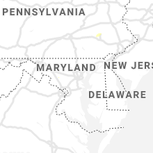
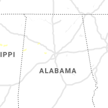
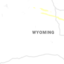
Hail Map for Wednesday, June 19, 2019

Number of Impacted Households on 6/19/2019
0
Impacted by 1" or Larger Hail
0
Impacted by 1.75" or Larger Hail
0
Impacted by 2.5" or Larger Hail
Square Miles of Populated Area Impacted on 6/19/2019
0
Impacted by 1" or Larger Hail
0
Impacted by 1.75" or Larger Hail
0
Impacted by 2.5" or Larger Hail


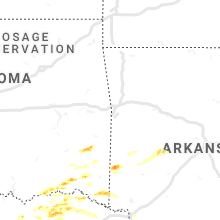


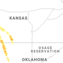


Cities Most Affected by Hail Storms of 6/19/2019
| Hail Size | Demographics of Zip Codes Affected | ||||||
|---|---|---|---|---|---|---|---|
| City | Count | Average | Largest | Pop Density | House Value | Income | Age |
| Coleman, TX | 3 | 3.25 | 4.00 | 15 | $34k | $25.8k | 45.4 |
| Cove, AR | 3 | 2.83 | 4.00 | 25 | $36k | $22.0k | 41.8 |
| Woodward, OK | 3 | 2.17 | 2.50 | 33 | $62k | $33.4k | 36.3 |
| Santa Anna, TX | 2 | 1.75 | 1.75 | 4 | $33k | $23.3k | 43.9 |
| Dodge City, KS | 1 | 3.00 | 3.00 | 82 | $71k | $37.6k | 29.5 |
| Sharon, OK | 1 | 2.75 | 2.75 | 10 | $54k | $40.8k | 37.8 |
| Sulphur Springs, TX | 1 | 2.75 | 2.75 | 82 | $64k | $31.7k | 38.3 |
| Ashland, KS | 1 | 2.75 | 2.75 | 0 | $37k | $34.7k | 44.3 |
| Farmersville, TX | 1 | 2.50 | 2.50 | 86 | $76k | $44.3k | 38.6 |
| Saltillo, TX | 1 | 2.50 | 2.50 | 17 | $44k | $29.6k | 40.8 |
| Soper, OK | 1 | 2.00 | 2.00 | 6 | $31k | $19.1k | 42.2 |
| Minneola, KS | 1 | 2.00 | 2.00 | 1 | $52k | $33.0k | 42.5 |
| Wickes, AR | 1 | 1.75 | 1.75 | 12 | $35k | $24.2k | 30.7 |
| Vici, OK | 1 | 1.75 | 1.75 | 5 | $36k | $27.6k | 41.3 |
| Anselmo, NE | 1 | 1.75 | 1.75 | 1 | $33k | $32.0k | 45.5 |
| Wingate, TX | 1 | 1.75 | 1.75 | 1 | $33k | $27.2k | 54.7 |
| Whitesboro, OK | 1 | 1.75 | 1.75 | 13 | $42k | $20.8k | 32.8 |
| Quitman, TX | 1 | 1.75 | 1.75 | 54 | $72k | $33.2k | 48.1 |
| Commerce, TX | 1 | 1.75 | 1.75 | 109 | $60k | $25.5k | 28.1 |
| Alba, TX | 1 | 1.75 | 1.75 | 49 | $85k | $31.8k | 46.7 |
| Brewster, NE | 1 | 1.75 | 1.75 | 1 | $19k | $24.0k | 45.5 |
| Celeste, TX | 1 | 1.75 | 1.75 | 31 | $54k | $40.0k | 40.5 |
Hail and Wind Damage Spotted on 6/19/2019
Filter by Report Type:Hail ReportsWind Reports
States Impacted
Louisiana, Florida, Missouri, Illinois, Montana, Kansas, Kentucky, Texas, South Dakota, Oklahoma, Wyoming, Tennessee, Arkansas, Nebraska, Ohio, Mississippi, Alabama, GeorgiaLouisiana
| Local Time | Report Details |
|---|---|
| 7:05 AM CDT | Light pole down near the intersection of millcent way and e. bert kouns. several large limbs were down in the university terrace subdivisio in caddo county LA, 6 miles SSE of Shreveport, LA |
| 7:12 AM CDT | Large tree limbs were downed on old mansfield road and mount bethel roa in caddo county LA, 14.3 miles SSW of Shreveport, LA |
| 7:12 AM CDT | A power line was downed on southern avenue and east 75th stree in caddo county LA, 5.1 miles S of Shreveport, LA |
| 7:15 AM CDT | Trees out of the ground mailbox is missing and shingles ripped off roofs. palmetto drive in bossie in bossier county LA, 1.9 miles NE of Shreveport, LA |
| 7:25 AM CDT | Tree down on norman street in shady grove subdivisio in bossier county LA, 2.8 miles E of Shreveport, LA |
| 10:30 PM CDT | Trees down from several location in the northern part of a the paris in caddo county LA, 28.3 miles NNW of Shreveport, LA |
| 11:11 PM CDT | Corrects previous tstm wnd dmg report from sarepta for the correct time. several trees and power lines down in the north part of the parish near sarept in webster county LA, 31.7 miles NNE of Shreveport, LA |
| 11:28 PM CDT | Trees down in several areas south of plain dealing and north of bento in bossier county LA, 20.5 miles NNE of Shreveport, LA |
| 11:35 PM CDT | The sheriff office reported isolated tree damage in the southwest part of the paris in claiborne county LA, 43.4 miles ENE of Shreveport, LA |
| 12:06 AM CDT | The sheriffs office reported trees down 2 miles east of bernic in union county LA, 41.7 miles W of Bastrop, LA |
| 1:00 AM CDT | Trees down near bienville along hwy. 9 and southeast of bienville along hwy. 15 in bienville county LA, 46.3 miles ESE of Shreveport, LA |
| 3:15 AM CDT | Wind damage througout ball. numerous trees snapped and/or blown down... some on homes. sign... awning... and window damage to businesses. time estimated from rada in rapides county LA, 85.9 miles NNW of Lafayette, LA |
| 3:15 AM CDT | Social media posts describing tree limbs and utility poles blown down on pardue rd. near tioga elementary. time estimated from rada in rapides county LA, 83.6 miles NNW of Lafayette, LA |
Florida
| Local Time | Report Details |
|---|---|
| 12:35 PM EDT | Few reports of trees down... including on a car and on power lines. time estimated from rada in levy county FL, 97.4 miles SW of Jacksonville, FL |
| 2:46 PM EDT | Trained spotter passed on photos showing a few downed trees in east and southeast ocala. time estiamted from rada in marion county FL, 63.1 miles NW of Orlando, FL |
| 3:19 PM EDT | Large tree downed across sunrail train tracks at magnolia avenue crossing in kissimmee. time estimated from airport observation in proximity to the location. from wesh in osceola county FL, 16.5 miles S of Orlando, FL |
| 3:19 PM EDT | Tree fell on a car on north beaumont ave in kissimmee. time estimated based on rada in osceola county FL, 16.5 miles S of Orlando, FL |
| 3:25 PM EDT | Tree fell on a house on country blvd. time estimated based on rada in osceola county FL, 13.8 miles S of Orlando, FL |
| 4:21 PM EDT | Large tree down across military trail... just south of linton blvd. blocking 3 lane in palm beach county FL, 49.5 miles N of Miami, FL |
| 4:40 PM EDT | Measured wind gust at air force tower 001 in brevard county FL, 49.7 miles E of Orlando, FL |
| 5:35 PM EDT | Large tree downed across sunrail train tracks at magnolia avenue crossing in kissimmee. time estimated from airport observation in proximity to the location. from wesh in osceola county FL, 16.5 miles S of Orlando, FL |
Missouri
| Local Time | Report Details |
|---|---|
| 1:00 PM CDT | Quarter sized hail reported near , , 73.7 miles SW of Cape Girardeau, MO, relayed from em. |
| 1:50 PM CDT | Trees down along highway 6 in scott county MO, 21.2 miles S of Cape Girardeau, MO |
| 2:15 PM CDT | Two trees down in cap in cape girardeau county MO, 0.6 miles NNW of Cape Girardeau, MO |
| 7:35 PM CDT | Plane overturned and pushed into building at poplar bluff municipal airport. fire department on sit in butler county MO, 56.5 miles SW of Cape Girardeau, MO |
| 7:35 PM CDT | Quarter sized hail reported near Poplar Bluff, MO, 59.9 miles SW of Cape Girardeau, MO |
| 7:35 PM CDT | Several telephone poles knocked down. numerous tree limbs down. power lines knocked down. pea size hai in butler county MO, 56.9 miles SW of Cape Girardeau, MO |
| 7:40 PM CDT | Corrects previous tstm wnd dmg report from 4 e poplar bluff for time of event. several telephone poles knocked down. numerous tree limbs down. power lines knocked dow in butler county MO, 56.9 miles SW of Cape Girardeau, MO |
| 7:41 PM CDT | 67 mph wind gust measured at poplar bluff airport aso in butler county MO, 56.5 miles SW of Cape Girardeau, MO |
| 7:55 PM CDT | Quarter sized hail reported near Fisk, MO, 52.1 miles SW of Cape Girardeau, MO |
| 7:55 PM CDT | Half Dollar sized hail reported near Fisk, MO, 51.5 miles SW of Cape Girardeau, MO |
| 9:00 PM CDT | Quarter sized hail reported near Lilbourn, MO, 49.3 miles S of Cape Girardeau, MO, quarter sized hail in lilbourn. |
| 9:10 PM CDT | Quarter sized hail reported near Chaffee, MO, 10.3 miles SW of Cape Girardeau, MO, nickle to quarter sized hail. wind estimated at 30 to 40 mph. |
| 9:20 PM CDT | Ping Pong Ball sized hail reported near Scott City, MO, 5.9 miles SSE of Cape Girardeau, MO |
Illinois
| Local Time | Report Details |
|---|---|
| 1:30 PM CDT | Tree knocked down with estimated 50 mph wind in saline county IL, 57.9 miles W of Evansville, IN |
| 2:05 PM CDT | Trees down. power outages reporte in pulaski county IL, 22.5 miles ESE of Cape Girardeau, MO |
| 3:00 PM CDT | Trees down in the round knob area. winds gusted to over 60 mp in massac county IL, 44.5 miles E of Cape Girardeau, MO |
| 3:13 PM CDT | Numerous trees and power poles downed in downtown. doors on courthouse blown out. damage to bradford supply commercial building. time estimated by rada in crawford county IL, 47.1 miles SE of Mattoon, IL |
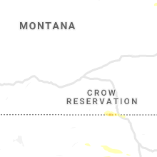
Montana
| Local Time | Report Details |
|---|---|
| 2:10 PM MDT | Quarter sized hail reported near , , 32.2 miles WNW of Glasgow, MT, lots of pea size hail... but some definitely as large as quarters. also estimated 1 inch of rainfall so far |
| 4:06 PM MDT | Asos station khvr havre ap asos. outflow wind from storm along the canadian borde in hill county MT, 4.5 miles W of Havre, MT |
| 4:13 PM MDT | Outflow wind gust from a thunderstorm along the canadian borde in hill county MT, 1 miles SSW of Havre, MT |
| 4:15 PM MDT | Several branches down in havre. damage and branch sizes are estimated from photos. one was approximately 8 to 10 inches in diameter... but it came from a dead tree. the in hill county MT, 1 miles SSW of Havre, MT |
| 8:44 PM MDT | Measured at king coulee raws site kigm8 in valley county MT, 32.6 miles SSW of Glasgow, MT |
Kansas
| Local Time | Report Details |
|---|---|
| 4:20 PM CDT | Storm damage reported in hodgeman county KS, 50.3 miles E of Garden City, KS |
| 4:34 PM CDT | Quarter sized hail reported near Jetmore, KS, 54.2 miles E of Garden City, KS |
| 4:35 PM CDT | Quarter sized hail reported near Jetmore, KS, 57.3 miles E of Garden City, KS |
| 4:49 PM CDT | Quarter sized hail reported near Dodge City, KS, 46.7 miles ESE of Garden City, KS |
| 4:54 PM CDT | Quarter sized hail reported near Cimarron, KS, 37.5 miles ESE of Garden City, KS, reported on social media. |
| 4:55 PM CDT | Quarter sized hail reported near Dodge City, KS, 48.3 miles ESE of Garden City, KS |
| 4:59 PM CDT | Storm damage reported in ford county KS, 58.4 miles E of Garden City, KS |
| 5:00 PM CDT | Quarter sized hail reported near Dodge City, KS, 48.8 miles ESE of Garden City, KS, reported through social media. |
| 5:30 PM CDT | Hen Egg sized hail reported near Minneola, KS, 55.7 miles ESE of Garden City, KS |
| 5:30 PM CDT | Tea Cup sized hail reported near Dodge City, KS, 54.9 miles ESE of Garden City, KS |
| 5:58 PM CDT | Quarter sized hail reported near Greensburg, KS, 80.6 miles N of Woodward, OK |
| 6:42 PM CDT | Baseball sized hail reported near Ashland, KS, 56.1 miles NNW of Woodward, OK |
| 6:55 PM CDT | Ping Pong Ball sized hail reported near Lake City, KS, 57.7 miles NNE of Woodward, OK |
| 6:55 PM CDT | Ping Pong Ball sized hail reported near Wilmore, KS, 64.8 miles NNE of Woodward, OK |
Kentucky
| Local Time | Report Details |
|---|---|
| 4:23 PM CDT | Report from kcey awos at kyle oakley fiel in calloway county KY, 37.3 miles NNE of Mc Kenzie, TN |
| 4:30 PM CDT | Late report. 2 trees and power lines down at intersection of hwy 80 and coleman trail roa in calloway county KY, 36.6 miles NNE of Mc Kenzie, TN |
| 4:35 PM CDT | Several trees dow in calloway county KY, 43.8 miles NNE of Mc Kenzie, TN |
| 4:49 PM CDT | Trees dow in trigg county KY, 55.6 miles NE of Mc Kenzie, TN |
| 6:10 PM CDT | Viewer sent video of a large tree snapped at base... and several broken branches. tree and branches appear to be hollo in butler county KY, 67.5 miles SE of Evansville, IN |
| 9:08 PM EDT | Metal roofing blown off a canop in taylor county KY, 48.5 miles SSE of Louisville, KY |
| 9:10 PM EDT | Siding from a barn was blown across a road at airport road and new lebanon roa in taylor county KY, 48.5 miles SSE of Louisville, KY |
Texas
| Local Time | Report Details |
|---|---|
| 4:31 PM CDT | Half Dollar sized hail reported near Anna, TX, 41.5 miles NNE of Dallas, TX, half dollar size hail in anna |
| 4:44 PM CDT | Quarter sized hail reported near Anna, TX, 40 miles NNE of Dallas, TX, quarter size hail near westminster |
| 5:00 PM CDT | Quarter sized hail reported near Whitewright, TX, 53.4 miles NNE of Dallas, TX, quarter size hail in whitewright |
| 5:02 PM CDT | Tennis Ball sized hail reported near Farmersville, TX, 41.4 miles NE of Dallas, TX, tennis ball size hail between farmersville and blue ridge |
| 5:14 PM CDT | Quarter sized hail reported near Whitewright, TX, 57.4 miles NNE of Dallas, TX, quarter hail near randolph |
| 5:18 PM CDT | Golf Ball sized hail reported near Celeste, TX, 48.9 miles NE of Dallas, TX, golf ball size hail in celeste |
| 5:43 PM CDT | Business with roof damage at highway 380 and sayle street on south side of greenville in hunt county TX, 46.1 miles ENE of Dallas, TX |
| 6:03 PM CDT | Half Dollar sized hail reported near Campbell, TX, 54.2 miles ENE of Dallas, TX, half dollar size hail near campbell |
| 6:04 PM CDT | Golf Ball sized hail reported near Commerce, TX, 58.3 miles ENE of Dallas, TX, golf ball size hail southwest of commerce |
| 6:07 PM CDT | Ping Pong Ball sized hail reported near Campbell, TX, 55.2 miles ENE of Dallas, TX, ping pong ball size hail on i-30 east of campbell |
| 6:15 PM CDT | Tree uprooted in miller grove in hopkins county TX, 60.6 miles ENE of Dallas, TX |
| 6:19 PM CDT | Power poles broken and large limbs down southeast of greenville in hunt county TX, 53.9 miles ENE of Dallas, TX |
| 6:35 PM CDT | Quarter sized hail reported near Talpa, TX, 48.8 miles SSE of Abilene, TX |
| 6:50 PM CDT | Golf Ball sized hail reported near Coleman, TX, 43.8 miles SSE of Abilene, TX |
| 7:00 PM CDT | Golf Ball sized hail reported near Wingate, TX, 38.3 miles SW of Abilene, TX, pictures and video on social media. |
| 7:10 PM CDT | Quarter sized hail reported near Santa Anna, TX, 54.1 miles SSE of Abilene, TX, also 40-50mph winds estimated. |
| 7:10 PM CDT | Several large trees down blocking the roadwa in wood county TX, 88.3 miles E of Dallas, TX |
| 7:15 PM CDT | Power lines down at the spring market off main stree in runnels county TX, 36.1 miles SSW of Abilene, TX |
| 7:15 PM CDT | Two large trees down just east of county road 4430 and fm 852 in wood count in wood county TX, 90.8 miles WNW of Shreveport, LA |
| 7:20 PM CDT | Multiple trees dow in franklin county TX, 94.9 miles WSW of Nashville, AR |
| 7:28 PM CDT | Golf Ball sized hail reported near Santa Anna, TX, 54.8 miles SSE of Abilene, TX, lots of windows and windshields blown out do to wind driven hail. |
| 7:39 PM CDT | Tree down on barn along country road 122 in camp county TX, 77 miles WNW of Shreveport, LA |
| 7:44 PM CDT | Power poles snapped and trees knocked down on county road 3545 near leesbur in camp county TX, 83.7 miles WNW of Shreveport, LA |
| 7:49 PM CDT | Quarter sized hail reported near Deport, TX, 75.6 miles SE of Atoka, OK, mping report of quarter size hail. |
| 8:02 PM CDT | Trees down on county road 101 in franklin county TX, 92.9 miles ENE of Dallas, TX |
| 8:06 PM CDT | Grapefruit sized hail reported near Coleman, TX, 42.4 miles SSE of Abilene, TX, hail was reported 18 miles west of coleman on hwy 153. |
| 8:15 PM CDT | Quarter sized hail reported near Sulphur Springs, TX, 81 miles ENE of Dallas, TX, quarter size hail reported at fm-1537 and fm-69. |
| 8:16 PM CDT | Half Dollar sized hail reported near Sulphur Springs, TX, 81.5 miles ENE of Dallas, TX, mping report of half dollar size hail. |
| 8:18 PM CDT | Grapefruit sized hail reported near Coleman, TX, 46.4 miles SSE of Abilene, TX, windows have been busted out do to wind driven golfball to softball size hail. |
| 8:25 PM CDT | Quarter sized hail reported near Avinger, TX, 51 miles WNW of Shreveport, LA |
| 8:32 PM CDT | Baseball sized hail reported near Sulphur Springs, TX, 78.7 miles ENE of Dallas, TX, baseball size hail reported six miles east of sulphur springs. |
| 8:33 PM CDT | Tennis Ball sized hail reported near Saltillo, TX, 83.6 miles ENE of Dallas, TX, tennis ball size hail reported at i-30 exit 135. |
| 8:34 PM CDT | Quarter sized hail reported near Santa Anna, TX, 54.8 miles SSE of Abilene, TX, quarter size hail falling in town. |
| 8:38 PM CDT | Golf Ball sized hail reported near Santa Anna, TX, 54.5 miles SSE of Abilene, TX, golfball to slightly larger hail is currently falling in town... off main street. |
| 8:50 PM CDT | Quarter sized hail reported near Paris, TX, 59.7 miles SSE of Atoka, OK, quarter size reported three miles west of paris. |
| 8:50 PM CDT | Quarter sized hail reported near Mount Vernon, TX, 91.3 miles WNW of Shreveport, LA, several reports of 1 inch hail from across the county. |
| 8:55 PM CDT | Quarter sized hail reported near Paris, TX, 61.2 miles SE of Atoka, OK, quarter size hail reported in paris. |
| 9:03 PM CDT | Quarter sized hail reported near Pittsburg, TX, 84.2 miles WNW of Shreveport, LA, 1 inch hail reported by a spotter in leesburg. |
| 9:04 PM CDT | Quarter sized hail reported near Paris, TX, 65.2 miles SE of Atoka, OK, quarter size hail reported two miles south of sun valley. (mping) |
| 9:07 PM CDT | Quarter sized hail reported near Blossom, TX, 64.9 miles SE of Atoka, OK, quarter size hail reported one mile north of blossom. |
| 9:08 PM CDT | Half Dollar sized hail reported near Mckinney, TX, 30.8 miles NNE of Dallas, TX, half dollar size hail reported in mckinney. |
| 9:10 PM CDT | Quarter sized hail reported near Mckinney, TX, 31.8 miles NNE of Dallas, TX, social media report of one-inch diameter hail at us-75 and us-380 in mckinney. |
| 9:19 PM CDT | Quarter sized hail reported near Paris, TX, 61.8 miles SE of Atoka, OK, quarter size hail reported three miles west of sun valley via mping. |
| 9:48 PM CDT | Quarter sized hail reported near Farmersville, TX, 36.6 miles NE of Dallas, TX, quarter size hail reported in farmersville. |
| 9:58 PM CDT | Reported at waco regional airport (kact in mclennan county TX, 45.3 miles NE of Killeen, TX |
| 10:08 PM CDT | Trees down in woodwa in mclennan county TX, 41.8 miles NE of Killeen, TX |
| 10:28 PM CDT | Trees reported down in the karnack communit in harrison county TX, 26.3 miles WNW of Shreveport, LA |
| 10:30 PM CDT | Delayed report: em reported several trees down and a house with a roof blown off in the city of dawso in navarro county TX, 62 miles S of Dallas, TX |
| 10:35 PM CDT | Wind gust to 61 mph measured at sulphur springs municipal airport (kslr in hopkins county TX, 73.6 miles ENE of Dallas, TX |
| 10:50 PM CDT | Wind gust to 58 mph measured by home weather station near rosebu in falls county TX, 42.5 miles E of Killeen, TX |
| 11:05 PM CDT | Half Dollar sized hail reported near Alba, TX, 70.8 miles E of Dallas, TX, half dollar size hail reported just west of lake fork dam. |
| 11:11 PM CDT | Golf Ball sized hail reported near Quitman, TX, 78.9 miles E of Dallas, TX, report of dime to golf ball size hail in quitman. |
| 11:30 PM CDT | Widespread trees and power lines down along with power outages in mineol in wood county TX, 76.4 miles E of Dallas, TX |
| 11:35 PM CDT | Golf Ball sized hail reported near Alba, TX, 70.8 miles E of Dallas, TX, golf ball sized hail along hwy 69 near golden. |
| 11:40 PM CDT | Quarter sized hail reported near Paris, TX, 63 miles SE of Atoka, OK, 1 inch hail reported 2 miles southeast of paris on us hwy 271. |
| 12:30 AM CDT | Power lines dow in rusk county TX, 62.5 miles NNW of Lufkin, TX |
| 1:30 AM CDT | Power lines were downed in the huxley communit in shelby county TX, 52.5 miles S of Shreveport, LA |
| 2:23 AM CDT | Quarter sized hail reported near Stephenville, TX, 70.9 miles N of Killeen, TX |
| 3:45 AM CDT | Quarter sized hail reported near Waco, TX, 45.3 miles NE of Killeen, TX, dime to quarter sized hail report relayed via social media. |
| 4:19 AM CDT | Quarter sized hail reported near Marlin, TX, 50.6 miles ENE of Killeen, TX, delayed report of quarter sized hail via waco media. time estimated via radar. |
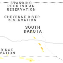
South Dakota
| Local Time | Report Details |
|---|---|
| 5:34 PM CDT | Half Dollar sized hail reported near Hamill, SD, 59.8 miles SSE of Pierre, SD |
| 6:17 PM CDT | Quarter sized hail reported near Hamill, SD, 63.4 miles NE of Valentine, NE |
| 6:44 PM CDT | Quarter sized hail reported near Dallas, SD, 63.9 miles NE of Valentine, NE, reported quarter sized hail... along with lots of small hail covering the ground. |
Oklahoma
| Local Time | Report Details |
|---|---|
| 5:35 PM CDT | Sheriff department reports trees down on old state hwy 98 near wright cit in mccurtain county OK, 67.1 miles ESE of Atoka, OK |
| 5:46 PM CDT | Quarter sized hail reported near Idabel, OK, 56 miles W of Nashville, AR |
| 6:05 PM CDT | Half Dollar sized hail reported near Broken Bow, OK, 50.8 miles W of Nashville, AR, public reports hail via social media pictures near broken bow. |
| 6:25 PM CDT | Trees snapped with the possibility of a tornad in mccurtain county OK, 47.3 miles W of Nashville, AR |
| 6:38 PM CDT | Ping Pong Ball sized hail reported near Boswell, OK, 31.6 miles SSE of Atoka, OK, hail size estimated from picture on social media. time estimated from radar. |
| 6:58 PM CDT | Hen Egg sized hail reported near Soper, OK, 35.2 miles SE of Atoka, OK, hail estimated to be 2 inches from picture on social media. time is estimated from radar. |
| 7:15 PM CDT | Quarter sized hail reported near Hugo, OK, 43.8 miles SE of Atoka, OK, 1 inch hail reported in hugo by trained spotter. |
| 7:16 PM CDT | Ping Pong Ball sized hail reported near Hugo, OK, 45.7 miles SE of Atoka, OK, 1.5 inch hail measured by public on social media. time is estimated from radar. |
| 7:35 PM CDT | Quarter sized hail reported near Buffalo, OK, 30.8 miles NNW of Woodward, OK |
| 8:10 PM CDT | Hen Egg sized hail reported near Woodward, OK, 5.3 miles N of Woodward, OK |
| 8:15 PM CDT | Golf Ball sized hail reported near Woodward, OK, 2.5 miles NW of Woodward, OK |
| 8:20 PM CDT | Storm damage reported in woodward county OK, 2.5 miles NW of Woodward, OK |
| 8:26 PM CDT | Ping Pong Ball sized hail reported near Woodward, OK, 0.6 miles ESE of Woodward, OK |
| 8:26 PM CDT | Tennis Ball sized hail reported near Woodward, OK, 0.6 miles ESE of Woodward, OK |
| 8:44 PM CDT | Baseball sized hail reported near Sharon, OK, 11.1 miles SSE of Woodward, OK |
| 9:00 PM CDT | Golf Ball sized hail reported near Vici, OK, 19.8 miles S of Woodward, OK |
| 10:05 PM CDT | Quarter sized hail reported near Sawyer, OK, 47.9 miles ESE of Atoka, OK, dime to quarter size hail reported on social media |
| 11:03 PM CDT | Golf Ball sized hail reported near Whitesboro, OK, 54.8 miles SSW of Fort Smith, AR, picture of hail relayed via social media. |
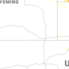
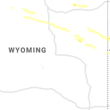
Wyoming
| Local Time | Report Details |
|---|---|
| 4:47 PM MDT | Quarter sized hail reported near Parkman, WY, 75.8 miles SE of Billings, MT |
| 5:29 PM MDT | Quarter sized hail reported near Hulett, WY, 44.7 miles NE of Gillette, WY |
| 6:30 PM MDT | Storm damage reported in campbell county WY, 48.3 miles SSW of Gillette, WY |
| 6:58 PM MDT | Quarter sized hail reported near Gillette, WY, 51.6 miles S of Gillette, WY |
| 7:33 PM MDT | Quarter sized hail reported near Gillette, WY, 8.1 miles N of Gillette, WY |
| 7:39 PM MDT | Quarter sized hail reported near Gillette, WY, 7 miles NNE of Gillette, WY |
| 7:45 PM MDT | Half Dollar sized hail reported near Douglas, WY, 60.1 miles ENE of Casper, WY, a trained spotter reported quarter to half dollar size hail and branches down in their parking lot as of 745 pm. |
| 8:23 PM MDT | Storm damage reported in crook county WY, 27.7 miles E of Gillette, WY |
| 9:05 PM MDT | Storm damage reported in weston county WY, 47.8 miles SE of Gillette, WY |
| 9:12 PM MDT | Quarter sized hail reported near Newcastle, WY, 52.6 miles SSE of Gillette, WY |
| 9:20 PM MDT | Storm damage reported in weston county WY, 56.8 miles SE of Gillette, WY |
Tennessee
| Local Time | Report Details |
|---|---|
| 6:11 PM CDT | Numerous trees down and minor roof damage in montgomery county TN, 32.2 miles WNW of Nashville, TN |
| 6:28 PM CDT | Trees and branches down along the side of i-24 in robertson county in robertson county TN, 21.1 miles NW of Nashville, TN |
| 6:28 PM CDT | Several trees down on old clarksville pike in cheatham county TN, 20.6 miles NW of Nashville, TN |
| 6:56 PM CDT | Tree down on 48 north in hickman county TN, 43.1 miles WSW of Nashville, TN |
| 7:16 PM CDT | Tree down on powerline. tranformer fell and damaged 2 cars north of hendersonvill in sumner county TN, 12.8 miles NE of Nashville, TN |
| 7:20 PM CDT | Fireworks tent thrown near hillsboro hs in davidson county TN, 5.2 miles SSW of Nashville, TN |
| 7:22 PM CDT | Numerous trees down in the area of lipscomb university in davidson county TN, 4.2 miles SSW of Nashville, TN |
| 7:22 PM CDT | Large tree down in davidson county TN, 4.4 miles SSW of Nashville, TN |
| 7:25 PM CDT | Large tree down in davidson county TN, 4.7 miles S of Nashville, TN |
| 7:28 PM CDT | 3 trees down on mccall st near nolensville pike in davidson county TN, 5.1 miles SSE of Nashville, TN |
| 7:34 PM CDT | Tree down on critz lane between hwy 31 and hwy 431 in williamson county TN, 25.2 miles SSW of Nashville, TN |
| 7:37 PM CDT | Power lines down and large tree on brushboro drive in williamson county TN, 10.9 miles S of Nashville, TN |
| 7:41 PM CDT | Tree down on edmondson pike in williamson county TN, 11.8 miles S of Nashville, TN |
| 7:41 PM CDT | Tree down on willomet lane in williamson county TN, 12.8 miles SSE of Nashville, TN |
| 7:41 PM CDT | Powerlines down on coxboro drive in williamson county TN, 11.7 miles S of Nashville, TN |
| 7:45 PM CDT | Large tree uprooted in duncanwood subdivision in davidson county TN, 5.2 miles SSW of Nashville, TN |
| 8:13 PM CDT | Trees down on swan creek road in hickman county TN, 50.5 miles SW of Nashville, TN |
| 8:17 PM CDT | Powerlines down near intersection of sedberry and evergreen roads in williamson county TN, 26.1 miles SSW of Nashville, TN |
| 8:17 PM CDT | Trees down on ugly creek road... as well as several other spots in hickman county. this would include hwy 230 east... hwy 100 west and hwy 43 in hickman county TN, 44.8 miles SW of Nashville, TN |
| 8:19 PM CDT | Downed trees and debris on buckner road between hwy 431 and hwy 31 in williamson county TN, 27.7 miles SSW of Nashville, TN |
| 8:19 PM CDT | Large tree uprooted in williamson county TN, 26.7 miles S of Nashville, TN |
| 8:21 PM CDT | Tree down on sulphur springs road near oakleigh subdivision in rutherford county TN, 26.8 miles SE of Nashville, TN |
| 8:21 PM CDT | Tree down in front of house... blocking entrance in maury county TN, 29.5 miles SSW of Nashville, TN |
| 8:22 PM CDT | Tree down at kedron road and jackson st in maury county TN, 30.7 miles SSW of Nashville, TN |
| 8:22 PM CDT | Powerlines down on bell st near mtsu in rutherford county TN, 31.7 miles SE of Nashville, TN |
| 8:22 PM CDT | Tree on powerlines causing fire on jones blvd near northfield blvd in rutherford county TN, 29.5 miles SE of Nashville, TN |
| 8:22 PM CDT | Trees and powerlines down in front of summit high school in williamson county TN, 27.9 miles S of Nashville, TN |
| 8:23 PM CDT | Tree down on brookrun and grange road in rutherford county TN, 27.2 miles SE of Nashville, TN |
| 8:24 PM CDT | Tree down on baker road near browns chapel road in rutherford county TN, 23.5 miles SE of Nashville, TN |
| 8:24 PM CDT | Tree down in the sanmar drive area in williamson county TN, 28.6 miles S of Nashville, TN |
| 8:50 PM CDT | Trees down in new middleton in smith county TN, 43 miles E of Nashville, TN |
| 9:10 PM CDT | Trees reportedly down on unionville deason road in bedford county TN, 42.6 miles SSE of Nashville, TN |
| 9:10 PM CDT | Tree on a power line on pine creek drive in de kalb county TN, 54.2 miles ESE of Nashville, TN |
| 9:20 PM CDT | Large tree down in farmingdale subdivision in rutherford county TN, 15.5 miles SE of Nashville, TN |
| 9:21 PM CDT | Tree on a power line on ellison goolsby ln in jackson county TN, 64.8 miles E of Nashville, TN |
| 9:35 PM CDT | Trees down on west bronson st and country club road in sparta in white county TN, 61.6 miles N of Chattanooga, TN |
| 9:36 PM CDT | Trees down on gaines st in white county TN, 60.7 miles N of Chattanooga, TN |
| 9:50 PM CDT | Trees down... power outage on rocky point road and shady lane road in putnam county TN, 75.5 miles N of Chattanooga, TN |
| 10:10 PM CDT | Several trees down and cars damaged near batesville casket company on highway 55 along with nickel size hail in coffee county TN, 52.7 miles NW of Chattanooga, TN |
| 11:50 PM EDT | Quarter sized hail reported near Helenwood, TN, 48.2 miles NW of Knoxville, TN |
| 12:13 AM EDT | Several trees dow in scott county TN, 43.6 miles NW of Knoxville, TN |
| 11:54 PM CDT | Memphis airport 58 kt gust in shelby county TN, 8.5 miles SSE of Memphis, TN |
| 11:59 PM CDT | Large tree down in near millingto in shelby county TN, 12.4 miles NNE of Memphis, TN |
| 12:13 AM CDT | Several trees down across tipton county... specifically in the drummond... quito... and covington areas. also widespread power outage in tipton county TN, 36.7 miles NE of Memphis, TN |
| 4:00 AM CDT | Multiple trees down across the county and power outages reporte in moore county TN, 62.2 miles WNW of Chattanooga, TN |
| 4:20 AM CDT | Tree fell on mobile home on greens mill rd. occupant is ok. damage reported to vehicles. tree is also blocking gravel hill rd. delayed repor in maury county TN, 34 miles SSW of Nashville, TN |
| 4:41 AM CDT | Trees and power lines down across south pittsbur in marion county TN, 22.7 miles W of Chattanooga, TN |
| 5:59 AM EDT | Large tree down on front porch of home at 7900 block selcer rd hixo in hamilton county TN, 11.9 miles NNE of Chattanooga, TN |
| 6:15 AM EDT | Trees and power lines dow in hamilton county TN, 12 miles N of Chattanooga, TN |
| 6:30 AM EDT | Several trees down across the count in hamilton county TN, 18.5 miles NE of Chattanooga, TN |
| 6:51 AM EDT | Severe trees down across the plateau area in rhea county TN, 39.6 miles NNE of Chattanooga, TN |
| 7:01 AM EDT | Several trees dow in mcminn county TN, 48.8 miles NE of Chattanooga, TN |
| 7:22 AM EDT | Several trees down across madisonville and sweetwate in monroe county TN, 36.7 miles SW of Knoxville, TN |
Arkansas
| Local Time | Report Details |
|---|---|
| 6:50 PM CDT | Golf Ball sized hail reported near Wickes, AR, 37.3 miles NW of Nashville, AR, golf ball size hail reported in wickes. |
| 6:53 PM CDT | Golf Ball sized hail reported near Cove, AR, 41.3 miles NW of Nashville, AR |
| 6:58 PM CDT | Grapefruit sized hail reported near Cove, AR, 42.2 miles NW of Nashville, AR, numerous images on social media display extremely large hailstones in the vandervoort/cove area. significant damage was done to some vehicles in the area. |
| 6:58 PM CDT | Baseball sized hail reported near Cove, AR, 42.2 miles NW of Nashville, AR |
| 7:00 PM CDT | Trees dow in sevier county AR, 29 miles WNW of Nashville, AR |
| 7:05 PM CDT | Several trees down along rt 41 near winthro in little river county AR, 32.1 miles WSW of Nashville, AR |
| 7:46 PM CDT | Trees were blown dow in montgomery county AR, 36.6 miles NNE of Nashville, AR |
| 7:55 PM CDT | Large tree down on miller 17 roa in miller county AR, 40.1 miles S of Nashville, AR |
| 8:15 PM CDT | County roads 5 and 25 are both closed due to trees blocking the roa in lafayette county AR, 38.5 miles SSE of Nashville, AR |
| 8:15 PM CDT | Ar 29 closed due to trees blocking roadwa in lafayette county AR, 42.7 miles SSE of Nashville, AR |
| 8:20 PM CDT | Nevada sheriffs office reported several trees down in the southern part of the county blocking several road in nevada county AR, 43.1 miles SE of Nashville, AR |
| 8:23 PM CDT | Trees and powerlines dow in garland county AR, 49.3 miles NE of Nashville, AR |
| 8:40 PM CDT | Columbia county sheriffs office reported several trees and power lines down across the county blocking road in columbia county AR, 58.7 miles SE of Nashville, AR |
| 8:41 PM CDT | Numerous trees and powerlines down in camden. trees are reported to be down on some home in ouachita county AR, 63.6 miles ESE of Nashville, AR |
| 8:44 PM CDT | Trees and powerlines dow in saline county AR, 23.5 miles WSW of Little Rock, AR |
| 9:00 PM CDT | Estimated gust along congo roa in saline county AR, 19.4 miles WSW of Little Rock, AR |
| 9:02 PM CDT | Storm damage reported in ouachita county AR, 58.1 miles SE of Nashville, AR |
| 9:10 PM CDT | Union county sheriffs office reported several trees blocking roads in the count in union county AR, 51.3 miles NW of Bastrop, LA |
| 9:10 PM CDT | Numerous trees down across the are in calhoun county AR, 57.7 miles NNW of Bastrop, LA |
| 9:11 PM CDT | 60 mph wind gust on pinnacle valley roa in pulaski county AR, 7.8 miles W of Little Rock, AR |
| 9:23 PM CDT | Storm damage reported in pulaski county AR, 3.4 miles ESE of Little Rock, AR |
| 9:25 PM CDT | Tree was snapped along shelby roa in pulaski county AR, 6.7 miles NNE of Little Rock, AR |
| 9:25 PM CDT | A tree was blown down onto highway 8 near highway 18 in bradley county AR, 64.6 miles N of Bastrop, LA |
| 9:25 PM CDT | A tree was blown onto a hous in lonoke county AR, 11.7 miles E of Little Rock, AR |
| 9:32 PM CDT | Storm damage reported in pulaski county AR, 13.8 miles NNE of Little Rock, AR |
| 9:38 PM CDT | Trees limbs were blown dow in pulaski county AR, 0.8 miles NNE of Little Rock, AR |
| 9:41 PM CDT | Numerous trees and powerlines dow in pulaski county AR, 3.3 miles WNW of Little Rock, AR |
| 9:42 PM CDT | Widespread trees blown down in cabo in lonoke county AR, 21 miles NE of Little Rock, AR |
| 9:45 PM CDT | Damage to houses reported in montongo. trees and powerlines are down county wid in drew county AR, 65.8 miles N of Bastrop, LA |
| 9:46 PM CDT | Trees were blown down along jim hall road near old tom box roa in pulaski county AR, 12.5 miles NNE of Little Rock, AR |
| 9:48 PM CDT | Storm spotter reports 70 mph thunderstorm wind gust in pulaski county AR, 14.4 miles NNE of Little Rock, AR |
| 9:53 PM CDT | A tree was blown down on highway 73 north of hambur in ashley county AR, 33.1 miles N of Bastrop, LA |
| 9:53 PM CDT | Mobile home damaged in florence. one person possibly trapped inside the building. numerous trees down around the propert in drew county AR, 70 miles NNE of Bastrop, LA |
| 9:54 PM CDT | A tree was blown down on maris saline roa in ashley county AR, 26.8 miles N of Bastrop, LA |
| 9:55 PM CDT | Several trees down... including one on a house. a pole barn was also destroyed in the are in lincoln county AR, 67.4 miles SSE of Little Rock, AR |
| 10:05 PM CDT | Trees were blown down. power poles were snapped. tree was blown down on a house and car on highway 208. trees uprooted at dermott villas apartment in chicot county AR, 58.9 miles NNE of Bastrop, LA |
| 10:05 PM CDT | Several trees and powerlines down... with some roads blocke in desha county AR, 66.1 miles NNE of Bastrop, LA |
| 10:08 PM CDT | Storm damage reported in prairie county AR, 41.4 miles ESE of Little Rock, AR |
| 10:10 PM CDT | A few trees down in the are in desha county AR, 77 miles NNE of Bastrop, LA |
| 10:15 PM CDT | A few trees down in the are in desha county AR, 82.9 miles SE of Little Rock, AR |
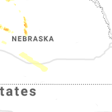
Nebraska
| Local Time | Report Details |
|---|---|
| 7:32 PM CDT | Golf Ball sized hail reported near Brewster, NE, 64.3 miles WSW of Oneill, NE |
| 7:59 PM CDT | Golf Ball sized hail reported near Anselmo, NE, 67.5 miles SW of Oneill, NE |
| 8:40 PM CDT | Quarter sized hail reported near Anselmo, NE, 68.1 miles NE of North Platte, NE |
| 8:45 PM CDT | Half Dollar sized hail reported near Anselmo, NE, 68.5 miles ENE of North Platte, NE, most stones were the size of quarters to half dollar. |
Ohio
| Local Time | Report Details |
|---|---|
| 9:45 PM EDT | Numerous trees dow in pike county OH, 67.5 miles S of Columbus, OH |
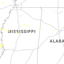
Mississippi
| Local Time | Report Details |
|---|---|
| 10:20 PM CDT | Large limbs downed in this area between lamont and scott in bolivar count in bolivar county MS, 71.9 miles NE of Bastrop, LA |
| 10:30 PM CDT | *** 1 fatal *** tree fell on a mobile home... causing 1 fatality... on west county line road... just west of north broadway extende in bolivar county MS, 74.6 miles NE of Bastrop, LA |
| 10:31 PM CDT | Measured at mid-delta regional airpor in washington county MS, 73.1 miles NE of Bastrop, LA |
| 10:40 PM CDT | Trees and power lines were blown down in cleveland. sporadic trees were blown down across the count in bolivar county MS, 96.3 miles NE of Bastrop, LA |
| 10:45 PM CDT | Report of trees down in avon area. windows were damaged at a residence... a pier was damaged and a boat was blown over on truck. relayed via social medi in washington county MS, 59.5 miles ENE of Bastrop, LA |
| 10:46 PM CDT | 2 street lights at the quality inn were blown down. pieces of roof being blown of in sunflower county MS, 84.4 miles NNW of Jackson, MS |
| 11:10 PM CDT | Report of downed powerline at the 200 block of washington street in belzon in humphreys county MS, 64 miles NNW of Jackson, MS |
| 11:30 PM CDT | Reports of trees downed in the highway 17 and highway 35 area of carroll count in carroll county MS, 64 miles W of Starkville, MS |
| 11:35 PM CDT | Powerline downed on county road 286 near the grenada county lin in carroll county MS, 61.5 miles WNW of Starkville, MS |
| 11:40 PM CDT | Report of downed trees across the count in grenada county MS, 61.4 miles WNW of Starkville, MS |
| 11:40 PM CDT | Multiple downed trees and powerlines down across the county and in the winona are in montgomery county MS, 53.6 miles W of Starkville, MS |
| 11:55 PM CDT | A few trees down on highway 17s just north of picken in holmes county MS, 44.5 miles NNE of Jackson, MS |
| 11:55 PM CDT | Report of a few trees downed on highway 51 in between goodman and duran in holmes county MS, 52.5 miles NNE of Jackson, MS |
| 12:13 AM CDT | Reports of large limbs downed in the tomnolen and eupora area. likely sub-severe wind gust in webster county MS, 29.4 miles W of Starkville, MS |
| 12:15 AM CDT | Reports of trees and powerlines downed across the count in attala county MS, 53 miles WSW of Starkville, MS |
| 12:20 AM CDT | Tree downed on highway 15 south of mathisto in choctaw county MS, 18.8 miles WNW of Starkville, MS |
| 12:30 AM CDT | Tree and powerline downed on highway 35 in between the tyson chicken plant and singleto in leake county MS, 52.3 miles NE of Jackson, MS |
| 12:40 AM CDT | Tree down on a home near apple street. report relayed via social medi in oktibbeha county MS, 0.5 miles NW of Starkville, MS |
| 12:40 AM CDT | Report of a tree fell on a home on cole stree in oktibbeha county MS, 1.2 miles SSW of Starkville, MS |
| 12:45 AM CDT | Power outages reported near the lawndale communit in lee county MS, 54.9 miles N of Starkville, MS |
| 12:49 AM CDT | Power line down near airport roa in pontotoc county MS, 55.2 miles NNW of Starkville, MS |
| 12:50 AM CDT | Report of a sign blown down at the highway 82 and highway 45 alternate intersectio in lowndes county MS, 9 miles E of Starkville, MS |
| 12:50 AM CDT | Tree downed on turtleneck road near madde in leake county MS, 56.8 miles ENE of Jackson, MS |
| 12:50 AM CDT | Powerlines down in the west point are in clay county MS, 13.7 miles NE of Starkville, MS |
| 12:56 AM CDT | A tree split in half at wtva studio in lee county MS, 54.9 miles N of Starkville, MS |
| 2:25 AM CDT | Trees and power lines downed in the piney woods mobile home park just off oak ridge roa in warren county MS, 36.2 miles WNW of Jackson, MS |
Alabama
| Local Time | Report Details |
|---|---|
| 2:08 AM CDT | Tree down on cloyd blvd at the intersection of mall road. large limb on home on blair street. time estimate in lauderdale county AL, 4.6 miles NNE of Florence, AL |
| 2:15 AM CDT | Trees down on lakewood view road and river roa in colbert county AL, 12.9 miles E of Florence, AL |
| 2:45 AM CDT | Tree blocking roadway near the intersection of alliance rd and tom salter r in jefferson county AL, 19.3 miles W of Birmingham, AL |
| 3:06 AM CDT | Tree down near the smokerise community center near warrio in blount county AL, 24.8 miles N of Birmingham, AL |
| 3:10 AM CDT | Power lines down near the 10/22 intersection in pea ridg in shelby county AL, 26.3 miles SSW of Birmingham, AL |
| 3:10 AM CDT | Tree down on massey road in alabaste in shelby county AL, 20.8 miles S of Birmingham, AL |
| 3:12 AM CDT | Tree on powerlines near the green valley neighborhood in hoove in jefferson county AL, 9 miles S of Birmingham, AL |
| 3:18 AM CDT | Tree on house on edgewood drive in homewood. some cars damage in jefferson county AL, 3.5 miles S of Birmingham, AL |
| 3:18 AM CDT | Tree down across ready section road just east of highway 53. large trees limbs covering mckee road and toney school roa in madison county AL, 52.2 miles E of Florence, AL |
| 3:18 AM CDT | Tree down on county road 73 near randolp in chilton county AL, 36.7 miles S of Birmingham, AL |
| 3:25 AM CDT | Tree down on 82942 us hwy 278 near blountsvill in blount county AL, 47.9 miles NNE of Birmingham, AL |
| 3:37 AM CDT | Tree down at the intersection of nixon chapel road and pankey roa in marshall county AL, 55.4 miles NNE of Birmingham, AL |
| 3:50 AM CDT | Tree down on county road 479 near county road 25 in dekalb county AL, 65 miles NE of Birmingham, AL |
| 4:00 AM CDT | Tree blocking one lane on 202 s. 8th street in gadsde in etowah county AL, 57.7 miles NE of Birmingham, AL |
| 4:00 AM CDT | Tree down across highway 79 in skyline. a car ran into the tre in jackson county AL, 49.1 miles WSW of Chattanooga, TN |
| 4:00 AM CDT | Numerous trees and powerlines down in the downtown gadsden are in etowah county AL, 58.1 miles NE of Birmingham, AL |
| 4:12 AM CDT | Tree down involving power lines on tawannah trail near hokes bluf in etowah county AL, 62.3 miles ENE of Birmingham, AL |
| 4:39 AM CDT | *** 1 inj *** tree across road at the intersection of highway 68 and 168. a car ran into the downed tree resulting in one injur in dekalb county AL, 66.6 miles NE of Birmingham, AL |
Georgia
| Local Time | Report Details |
|---|---|
| 5:38 AM EDT | Trees down just north of cedartown in polk count in polk county GA, 53.4 miles WNW of Atlanta, GA |
| 6:40 AM EDT | Large tree down and blocking the roadway on upper bethany rd near the intersection with damascus r in cherokee county GA, 43.7 miles N of Atlanta, GA |
| 6:40 AM EDT | Tree reported down at the 5000 block of henderson mt r in pickens county GA, 46.3 miles N of Atlanta, GA |
| 6:42 AM EDT | Tree reported down near the 400 block of salem church r in pickens county GA, 48.5 miles N of Atlanta, GA |
| 6:45 AM EDT | Tree reported down on parker rd near the intersection with refuge r in pickens county GA, 47 miles N of Atlanta, GA |
Connect with Interactive Hail Maps