

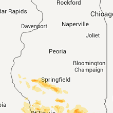
Hail Map for Saturday, June 25, 2011

Number of Impacted Households on 6/25/2011
0
Impacted by 1" or Larger Hail
0
Impacted by 1.75" or Larger Hail
0
Impacted by 2.5" or Larger Hail
Square Miles of Populated Area Impacted on 6/25/2011
0
Impacted by 1" or Larger Hail
0
Impacted by 1.75" or Larger Hail
0
Impacted by 2.5" or Larger Hail


Cities Most Affected by Hail Storms of 6/25/2011
| Hail Size | Demographics of Zip Codes Affected | ||||||
|---|---|---|---|---|---|---|---|
| City | Count | Average | Largest | Pop Density | House Value | Income | Age |
| Sidney, NE | 2 | 2.25 | 2.75 | 18 | $61k | $34.3k | 38.2 |
| Grafton, IL | 1 | 4.00 | 4.00 | 29 | $90k | $41.2k | 44.6 |
| Brewster, NE | 1 | 2.50 | 2.50 | 1 | $19k | $24.0k | 45.5 |
| Oshkosh, NE | 1 | 1.75 | 1.75 | 1 | $44k | $27.8k | 49.3 |
| Sturgis, SD | 1 | 1.75 | 1.75 | 15 | $79k | $34.9k | 44.7 |
| Clark, SD | 1 | 1.75 | 1.75 | 6 | $47k | $31.2k | 46.8 |
| Fessenden, ND | 1 | 1.75 | 1.75 | 2 | $31k | $34.4k | 52.8 |
| Hyannis, NE | 1 | 1.75 | 1.75 | 0 | $33k | $31.8k | 49.9 |
| Stanley, ND | 1 | 1.75 | 1.75 | 2 | $38k | $24.7k | 37.1 |
| Troy, KS | 1 | 1.75 | 1.75 | 13 | $56k | $33.8k | 40.2 |
| Chappell, NE | 1 | 1.75 | 1.75 | 1 | $50k | $36.1k | 47.6 |
| Hill City, SD | 1 | 1.75 | 1.75 | 3 | $97k | $36.2k | 47.3 |
| Cadet, MO | 1 | 1.75 | 1.75 | 68 | $50k | $27.6k | 36.8 |
| Dix, NE | 1 | 1.75 | 1.75 | 1 | $30k | $32.0k | 42.7 |
| Parshall, ND | 1 | 1.75 | 1.75 | 2 | $38k | $27.5k | 36.4 |
Hail and Wind Damage Spotted on 6/25/2011
Filter by Report Type:Hail ReportsWind Reports
States Impacted
Tennessee, Illinois, North Dakota, Georgia, Alabama, South Dakota, Nebraska, Wyoming, Missouri, Kansas, Indiana, MontanaTennessee
| Local Time | Report Details |
|---|---|
| 12:15 PM UTC | Quarter sized hail reported near Bradford, TN, 17.1 miles W of Mc Kenzie, TN |
Illinois
| Local Time | Report Details |
|---|---|
| 1:39 PM UTC | Quarter sized hail reported near Metropolis, IL, 45.3 miles E of Cape Girardeau, MO, 1+ inch hail reported in massac county near round knob |
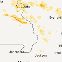
| 1:00 AM UTC | Grapefruit sized hail reported near Grafton, IL, 26.7 miles NNW of Saint Louis, MO, many 1 to 2 inch stones with a few up to 4 inches |
| 1:04 AM UTC | Quarter sized hail reported near Chatham, IL, 70.8 miles S of Peoria, IL |
| 1:45 AM UTC | Power lines down. time estimate in cass county IL, 69.6 miles SW of Peoria, IL |
| 1:50 AM UTC | Power lines down. time estimate in morgan county IL, 73 miles SW of Peoria, IL |
| 2:00 AM UTC | Corrected time. tree limbs and power lines down near route 78 and baldwin road in morgan county IL, 72.7 miles SSW of Peoria, IL |
| 2:13 AM UTC | Quarter sized hail reported near Chatham, IL, 69.8 miles W of Mattoon, IL |
| 3:00 AM UTC | Tree limbs and power lines down near route 78 and baldwin road in morgan county IL, 72.7 miles SSW of Peoria, IL |
| 4:05 AM UTC | Quarter sized hail reported near Alton, IL, 19 miles N of Saint Louis, MO, on northeast side of town. |
| 4:45 AM UTC | Large limbs and trees down onto power lines in clinton county IL, 50.3 miles E of Saint Louis, MO |
| 4:56 AM UTC | Large limb blown onto power lines in clinton county IL, 31.9 miles E of Saint Louis, MO |
North Dakota
| Local Time | Report Details |
|---|---|
| 8:29 PM UTC | Half Dollar sized hail reported near New Town, ND, 51.4 miles ESE of Williston, ND |
| 8:43 PM UTC | Quarter sized hail reported near New Town, ND, 54.2 miles ESE of Williston, ND |
| 9:14 PM UTC | Quarter sized hail reported near Stanley, ND, 56.1 miles WNW of Minot, ND, pea to quarter size hail... hail lasted about five minutes... |
| 9:14 PM UTC | Ping Pong Ball sized hail reported near New Town, ND, 54.4 miles ESE of Williston, ND, mostly pea to quarter size hail with few ping pong ball size hail... |
| 9:19 PM UTC | Golf Ball sized hail reported near Stanley, ND, 49.6 miles E of Williston, ND, public report relayed by broadcast media... |
| 10:09 PM UTC | Ping Pong Ball sized hail reported near Maxbass, ND, 34.2 miles NNE of Minot, ND, report relayed by media. |
| 10:15 PM UTC | Quarter sized hail reported near Mohall, ND, 37.5 miles NNW of Minot, ND, hail lasted until 530 pm cdt. |
| 10:23 PM UTC | Quarter sized hail reported near Newburg, ND, 35.3 miles NNE of Minot, ND |
| 10:23 PM UTC | Golf Ball sized hail reported near Parshall, ND, 43.8 miles WSW of Minot, ND |
| 10:42 PM UTC | Quarter sized hail reported near Maxbass, ND, 33.6 miles N of Minot, ND |
| 11:15 PM UTC | Ping Pong Ball sized hail reported near Upham, ND, 35.3 miles NE of Minot, ND, hail lasted for 10 minutes. |
| 11:23 PM UTC | Coop observer in minot north hill reported straight line winds... pea size hail... and 0.39 of rain in 5 to 15 mins in ward county ND, 0.5 miles SSW of Minot, ND |
| 12:20 AM UTC | Storm damage reported in mchenry county ND, 36 miles ENE of Minot, ND |
| 12:20 AM UTC | Storm damage reported in pierce county ND, 54 miles ENE of Minot, ND |
| 12:33 AM UTC | Law enforcement reported that a barn roof was located on state highway 3...and is blocking traffi in rolette county ND, 61.1 miles WNW of Devils Lake, ND |
| 12:33 AM UTC | Law enforcement reported that a barn roof was located on state highway 3...and is blocking traffic. winds estimated at 85 mp in rolette county ND, 61.1 miles WNW of Devils Lake, ND |
| 1:23 AM UTC | Golf Ball sized hail reported near Fessenden, ND, 48.1 miles SW of Devils Lake, ND, report relayed by broadcast media... quarter to golf ball size hail... |
| 1:24 AM UTC | Quarter sized hail reported near Fessenden, ND, 48.1 miles SW of Devils Lake, ND |
| 1:40 AM UTC | Quarter sized hail reported near Maddock, ND, 42 miles WSW of Devils Lake, ND, numerous nickel to quarter sized hail fail from 840 to 845 pm cdt. |
| 1:40 AM UTC | Quarter sized hail reported near Maddock, ND, 40.1 miles WSW of Devils Lake, ND, numerous nickel to quarter sized hail fail from 840 to 845 pm cdt. |
| 2:14 AM UTC | Quarter sized hail reported near New Salem, ND, 30.1 miles W of Bismarck, ND, multiple reports of quarter sized hail in new salem by law enforcement and public... |
| 2:29 AM UTC | Quarter sized hail reported near New Rockford, ND, 34.8 miles SSW of Devils Lake, ND, nickel and quarter sized hail just covered the ground. |
| 3:42 AM UTC | Ping Pong Ball sized hail reported near New Rockford, ND, 29.2 miles S of Devils Lake, ND, quarter to walnut sized hail and very heavy rain. |
Georgia
| Local Time | Report Details |
|---|---|
| 10:10 PM UTC | Trees and powerline reported down near browntown road. time of event based on rada in brantley county GA, 64.7 miles ESE of Douglas, GA |
| 11:24 PM UTC | Retired nws employee reported winds near 6 in glynn county GA, 50.8 miles NNE of Jacksonville, FL |
| 11:45 PM UTC | Park service on cumberland island reported 4 to 5 inch diameter tree limbs blown down. time of event based on rada in camden county GA, 36.9 miles NNE of Jacksonville, FL |
| 11:57 PM UTC | Liberty county 911 center reported one tree blown down on pocahontas roa in liberty county GA, 25.6 miles SW of Savannah, GA |
Alabama
| Local Time | Report Details |
|---|---|
| 6:10 PM CDT | Quarter sized hail reported near Birmingham, AL, 9.7 miles S of Birmingham, AL, at the galleria mall |
| 11:30 PM UTC | Quarter sized hail reported near Pelham, AL, 13.9 miles S of Birmingham, AL, estimated winds to 60 mph. have received several reports of quarter size hail between hoover and pelham. |
South Dakota
| Local Time | Report Details |
|---|---|
| 12:45 AM UTC | Storm damage reported in fall river county SD, 62.2 miles S of Rapid City, SD |
| 1:05 AM UTC | Storm damage reported in custer county SD, 46.2 miles WSW of Rapid City, SD |
| 7:50 PM MDT | Ping Pong Ball sized hail reported near Hill City, SD, 19.9 miles WSW of Rapid City, SD |
| 7:54 PM MDT | Golf Ball sized hail reported near Hill City, SD, 19.9 miles WSW of Rapid City, SD |
| 8:00 PM MDT | Quarter sized hail reported near Hill City, SD, 19.9 miles WSW of Rapid City, SD |
| 2:04 AM UTC | Quarter sized hail reported near Rapid City, SD, 14.4 miles WSW of Rapid City, SD |
| 2:07 AM UTC | Storm damage reported in pennington county SD, 13.8 miles WSW of Rapid City, SD |
| 2:10 AM UTC | Storm damage reported in custer county SD, 22.9 miles S of Rapid City, SD |
| 2:20 AM UTC | Half Dollar sized hail reported near Hill City, SD, 30.5 miles W of Rapid City, SD |
| 2:25 AM UTC | Quarter sized hail reported near Rapid City, SD, 3.7 miles SW of Rapid City, SD |
| 3:00 AM UTC | Half Dollar sized hail reported near Piedmont, SD, 15.3 miles NE of Rapid City, SD, 1.89 inches of rainfall |
| 3:05 AM UTC | Quarter sized hail reported near Piedmont, SD, 18.1 miles NE of Rapid City, SD |
| 3:40 AM UTC | Golf Ball sized hail reported near Sturgis, SD, 23 miles N of Rapid City, SD |
| 3:40 AM UTC | Storm damage reported in meade county SD, 23 miles N of Rapid City, SD |
| 3:48 AM UTC | Kphp asos observatio in haakon county SD, 65.9 miles WSW of Pierre, SD |
| 3:50 AM UTC | Half Dollar sized hail reported near Midland, SD, 33.2 miles W of Pierre, SD, lost some siding on the back of the house. estimated winds 60 to 70 mph. garden flattened. |
| 8:01 AM UTC | Golf Ball sized hail reported near Clark, SD, 43.6 miles SE of Aberdeen, SD |
| 9:15 AM UTC | Storm damage reported in harding county SD, 117 miles N of Rapid City, SD |
| 10:05 AM UTC | Storm damage reported in perkins county SD, 118.9 miles N of Rapid City, SD |
| 10:20 AM UTC | Storm damage reported in shannon county SD, 76.7 miles SE of Rapid City, SD |
Nebraska
| Local Time | Report Details |
|---|---|
| 12:54 AM UTC | Golf Ball sized hail reported near Dix, NE, 35.9 miles SSE of Scottsbluff, NE, golf ball sized hail lasted from 654 pm until 656 pm mdt. |
| 1:25 AM UTC | Semi blown over on interstate 80 just inside cheyenne county lin in cheyenne county NE, 46.8 miles SSE of Scottsbluff, NE |
| 1:30 AM UTC | Two large trees down in potter due to strong wind in cheyenne county NE, 47.9 miles SSE of Scottsbluff, NE |
| 2:07 AM UTC | Quarter sized hail reported near Sidney, NE, 62 miles SE of Scottsbluff, NE, quarter sized hail on the north side of town. spotter observed strong rotation to the west. |
| 2:11 AM UTC | Golf Ball sized hail reported near Sidney, NE, 62 miles SE of Scottsbluff, NE, golf ball sized hail on the west side of town. ongoing at the time of the report. |
| 2:20 AM UTC | Baseball sized hail reported near Sidney, NE, 62 miles SE of Scottsbluff, NE, numerous reports of golfball sized hail in and around sidney. baseball sized hail was reported on the north side of town. |
| 3:04 AM UTC | Ping Pong Ball sized hail reported near Sidney, NE, 64.4 miles SE of Scottsbluff, NE, mostly pea to marble hail. |
| 3:15 AM UTC | Golf Ball sized hail reported near Chappell, NE, 73.3 miles SE of Scottsbluff, NE, delayed report...public reported golf ball sized hail 8 miles nw of chappell |
| 5:30 AM UTC | Golf Ball sized hail reported near Oshkosh, NE, 68.4 miles E of Scottsbluff, NE, delayed report |
| 6:00 AM UTC | Golf Ball sized hail reported near Hyannis, NE, 80.6 miles NW of North Platte, NE, delayed report |
| 6:30 AM UTC | Tennis Ball sized hail reported near Brewster, NE, 69 miles SSE of Valentine, NE, delayed report...golf and tennis ball sized hail reported by public 5 miles n of brewster at 130 am |
Wyoming
| Local Time | Report Details |
|---|---|
| 1:07 AM UTC | Quarter sized hail reported near Torrington, WY, 31.3 miles WNW of Scottsbluff, NE |
Missouri
| Local Time | Report Details |
|---|---|
| 1:26 AM UTC | Quarter sized hail reported near Richwoods, MO, 46.6 miles SW of Saint Louis, MO |
| 3:50 AM UTC | Golf Ball sized hail reported near Cadet, MO, 49.5 miles ENE of Salem, MO, at the drive in movie theater |
| 3:55 AM UTC | Quarter sized hail reported near Cadet, MO, 49.4 miles SW of Saint Louis, MO |
| 4:05 AM UTC | Storm damage reported in st. francois county MO, 52.4 miles SSW of Saint Louis, MO |
| 4:10 AM UTC | Quarter sized hail reported near Bonne Terre, MO, 52.4 miles SSW of Saint Louis, MO |
| 4:19 AM UTC | Quarter sized hail reported near Owensville, MO, 47 miles N of Salem, MO |
| 4:24 AM UTC | Quarter sized hail reported near Hazelwood, MO, 13.6 miles NW of Saint Louis, MO, est 50 mph winds |
| 4:30 AM UTC | Large branch knocked out of tree onto power lines and then a house...near the intersection of jennings station and hoard road in st. louis county MO, 7.2 miles NNW of Saint Louis, MO |
| 5:00 AM UTC | 2 foot diameter tree blown over near the intersection of lindbergh and watson roads in st. louis county MO, 13.4 miles WSW of Saint Louis, MO |
| 5:03 AM UTC | Car blown off the road in old pattonsbur in daviess county MO, 69.5 miles NNE of Kansas City, MO |
| 5:04 AM UTC | Storm damage reported in linn county MO, 77.6 miles NW of Columbia, MO |
| 5:10 AM UTC | Numerous trees down and one structure damage in linn county MO, 62.4 miles NNW of Columbia, MO |
| 5:11 AM UTC | Highway 13 blocked by downed tre in daviess county MO, 68.3 miles NNE of Kansas City, MO |
| 5:30 AM UTC | High voltage power lines dow in linn county MO, 69.8 miles WSW of Kahoka, MO |
| 6:02 AM UTC | Quarter sized hail reported near Cottleville, MO, 25.8 miles WNW of Saint Louis, MO |
| 6:05 AM UTC | Quarter sized hail reported near St Charles, MO, 26.9 miles WNW of Saint Louis, MO |
| 6:05 AM UTC | Storm damage reported in st. louis county MO, 16.4 miles WNW of Saint Louis, MO |
| 6:42 AM UTC | Quarter sized hail reported near St Joseph, MO, 47.7 miles NNW of Kansas City, MO |
Kansas
| Local Time | Report Details |
|---|---|
| 5:07 AM UTC | Golf Ball sized hail reported near Troy, KS, 54.6 miles NNW of Kansas City, MO |
Indiana
| Local Time | Report Details |
|---|---|
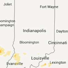
| 6:50 AM UTC | Tree down in dubois county IN, 43.3 miles NE of Evansville, IN |
| 6:54 AM UTC | Power lines and multiple trees down. trees blocking roads especially along cr 650w between duff and in 6 in dubois county IN, 35.8 miles NE of Evansville, IN |
| 7:00 AM UTC | Damage mostly to in spencer county IN, 32 miles E of Evansville, IN |
Montana
| Local Time | Report Details |
|---|---|
| 8:55 AM UTC | Quarter sized hail reported near Hammond, MT, 88.8 miles SE of Miles City, MT |
Connect with Interactive Hail Maps