

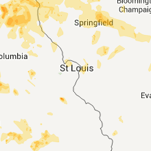
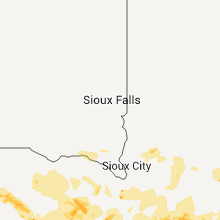
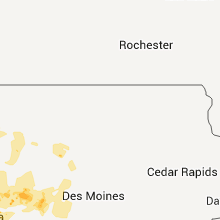
Hail Map for Sunday, June 26, 2011

Number of Impacted Households on 6/26/2011
0
Impacted by 1" or Larger Hail
0
Impacted by 1.75" or Larger Hail
0
Impacted by 2.5" or Larger Hail
Square Miles of Populated Area Impacted on 6/26/2011
0
Impacted by 1" or Larger Hail
0
Impacted by 1.75" or Larger Hail
0
Impacted by 2.5" or Larger Hail


Cities Most Affected by Hail Storms of 6/26/2011
| Hail Size | Demographics of Zip Codes Affected | ||||||
|---|---|---|---|---|---|---|---|
| City | Count | Average | Largest | Pop Density | House Value | Income | Age |
| Valentine, NE | 2 | 1.88 | 2.00 | 3 | $68k | $29.9k | 44.3 |
| Cadet, MO | 2 | 1.88 | 2.00 | 68 | $50k | $27.6k | 36.8 |
| Johnstown, NE | 2 | 1.75 | 1.75 | 1 | $33k | $29.1k | 48.3 |
| Merriman, NE | 2 | 1.75 | 1.75 | 0 | $30k | $26.6k | 47.3 |
| Lincoln, NE | 2 | 1.75 | 1.75 | 5051 | $74k | $26.8k | 26.7 |
| Hay Springs, NE | 1 | 2.75 | 2.75 | 1 | $36k | $31.1k | 52.3 |
| Treece, KS | 1 | 2.75 | 2.75 | 47 | $10k | $22.5k | 40.7 |
| Amelia, NE | 1 | 2.75 | 2.75 | 1 | $23k | $25.2k | 49.8 |
| Highland, KS | 1 | 2.50 | 2.50 | 11 | $50k | $30.3k | 27.3 |
| Cincinnati, IA | 1 | 2.00 | 2.00 | 16 | $26k | $28.4k | 40.0 |
| Burchard, NE | 1 | 2.00 | 2.00 | 2 | $20k | $28.4k | 48.9 |
| Oelrichs, SD | 1 | 1.75 | 1.75 | 0 | $25k | $29.5k | 50.6 |
| Rushville, NE | 1 | 1.75 | 1.75 | 1 | $43k | $28.7k | 42.9 |
| Maryville, MO | 1 | 1.75 | 1.75 | 93 | $91k | $32.0k | 24.0 |
| Jesup, GA | 1 | 1.75 | 1.75 | 171 | $75k | $31.8k | 36.3 |
| Burwell, NE | 1 | 1.75 | 1.75 | 1 | $39k | $26.8k | 50.4 |
| Ashby, NE | 1 | 1.75 | 1.75 | 0 | $29k | $47.2k | 46.2 |
| Troy, KS | 1 | 1.75 | 1.75 | 13 | $56k | $33.8k | 40.2 |
| Rapid City, SD | 1 | 1.75 | 1.75 | 114 | $83k | $38.6k | 33.9 |
| Centerville, IA | 1 | 1.75 | 1.75 | 59 | $48k | $28.5k | 43.1 |
| Latham, IL | 1 | 1.75 | 1.75 | 10 | $64k | $48.1k | 41.6 |
| Glenwood, IA | 1 | 1.75 | 1.75 | 87 | $106k | $45.5k | 39.8 |
Hail and Wind Damage Spotted on 6/26/2011
Filter by Report Type:Hail ReportsWind Reports
States Impacted
Iowa, Kansas, North Dakota, South Dakota, Georgia, Nebraska, Missouri, Tennessee, Alabama, South Carolina, Florida, North Carolina, Wyoming, Illinois, MinnesotaIowa
| Local Time | Report Details |
|---|---|
| 12:46 PM UTC | At least six homes with roof damage with shingles blown off. power lines downed. grain bin destroyed in the outskirts of tow in woodbury county IA, 59.5 miles WSW of Storm Lake, IA |
| 9:55 PM UTC | Quarter sized hail reported near Creston, IA, 52.4 miles SW of Des Moines, IA |
| 10:25 PM UTC | Quarter sized hail reported near Chariton, IA, 42.4 miles SSE of Des Moines, IA |
| 10:55 PM UTC | Quarter sized hail reported near Woodburn, IA, 42.8 miles S of Des Moines, IA |
| 11:00 PM UTC | Quarter sized hail reported near Massena, IA, 62.3 miles WSW of Des Moines, IA, nickel to quarter hail relayed to law enforcement from public. |
| 11:04 PM UTC | Electric pole partially blown over ... on highway 14 ...wires sparking in lucas county IA, 41.8 miles SSE of Des Moines, IA |
| 11:04 PM UTC | Electric pole partially blown over...wires sparking in lucas county IA, 41.8 miles SSE of Des Moines, IA |
| 11:12 PM UTC | 3 to 4 inch tree branches down with pea size hai in adair county IA, 53.6 miles WSW of Des Moines, IA |
| 11:21 PM UTC | Golf Ball sized hail reported near Centerville, IA, 64.2 miles WNW of Kahoka, MO, quarter to golf ball sized hail. |
| 11:22 PM UTC | Quarter sized hail reported near Centerville, IA, 63.9 miles WNW of Kahoka, MO, nickel to quarter sized hail covering parking lot. |
| 11:23 PM UTC | Quarter sized hail reported near Centerville, IA, 64.2 miles WNW of Kahoka, MO |
| 11:49 PM UTC | Storm damage reported in appanoose county IA, 64.2 miles WNW of Kahoka, MO |
| 12:07 AM UTC | Quarter sized hail reported near Udell, IA, 59.1 miles WNW of Kahoka, MO |
| 12:29 AM UTC | Large trees uprooted in the town of west grov in davis county IA, 50.2 miles WNW of Kahoka, MO |
| 12:30 AM UTC | Storm damage reported in woodbury county IA, 59.5 miles WSW of Storm Lake, IA |
| 12:40 AM UTC | Numerous four to eight diameter branches downe in woodbury county IA, 54 miles WSW of Storm Lake, IA |
| 12:40 AM UTC | One inch diameter branches downed in tow in woodbury county IA, 51.3 miles WSW of Storm Lake, IA |
| 12:40 AM UTC | Grain bend damage on edge of tow in davis county IA, 34.8 miles NW of Kahoka, MO |
| 12:40 AM UTC | Large trees down in pulaski from thunderstorm wind in davis county IA, 34.8 miles NW of Kahoka, MO |
| 12:45 AM UTC | Storm damage reported in monona county IA, 56.4 miles N of Omaha, NE |
| 12:46 AM UTC | Storm damage reported in woodbury county IA, 59.5 miles WSW of Storm Lake, IA |
| 12:46 AM UTC | At least six homes with roof damage with shingles blown off. power lines downed. grain bin destroyed in the outskirts of tow in woodbury county IA, 59.5 miles WSW of Storm Lake, IA |
| 12:52 AM UTC | 1 foot diameter tree blown down. some corn leaning. some corn snappe in harrison county IA, 40.9 miles N of Omaha, NE |
| 12:52 AM UTC | Storm damage reported in harrison county IA, 40.9 miles N of Omaha, NE |
| 12:53 AM UTC | Storm damage reported in woodbury county IA, 60.7 miles WSW of Storm Lake, IA |
| 12:55 AM UTC | Small hail and zero visibility in heavy rainfal in van buren county IA, 29.3 miles NW of Kahoka, MO |
| 12:55 AM UTC | Trees down in town in van buren county IA, 28.9 miles NW of Kahoka, MO |
| 12:59 AM UTC | Tree damage and power line damage from tree debris falling on power lines. power out. damaging winds continued for 20 minutes to at least 819 pm cd in woodbury county IA, 54.2 miles WSW of Storm Lake, IA |
| 1:00 AM UTC | Tree down on hous in van buren county IA, 23.9 miles NW of Kahoka, MO |
| 1:03 AM UTC | Storm damage reported in woodbury county IA, 62.6 miles WSW of Storm Lake, IA |
| 1:05 AM UTC | 50 to 60 mph winds in sioux city along with considerable street flooding in the downtown are in woodbury county IA, 61.5 miles W of Storm Lake, IA |
| 1:11 AM UTC | Storm damage reported in crawford county IA, 47 miles NNE of Omaha, NE |
| 1:15 AM UTC | Numerous tree branches down in woodbury county IA, 54 miles WSW of Storm Lake, IA |
| 1:15 AM UTC | Billboard blown over north of tow in van buren county IA, 26 miles NNW of Kahoka, MO |
| 1:25 AM UTC | Quarter sized hail reported near Mt Sterling, IA, 15.9 miles NNW of Kahoka, MO, hail ended at 825 pm |
| 1:25 AM UTC | Tree down on mobile home in van buren county IA, 15.2 miles N of Kahoka, MO |
| 1:28 AM UTC | Storm damage reported in shelby county IA, 41.5 miles NE of Omaha, NE |
| 1:30 AM UTC | Power lines down in crawford county IA, 51.7 miles SSW of Storm Lake, IA |
| 1:30 AM UTC | 1-2 diameter branches down due to strong winds in woodbury county IA, 42.9 miles W of Storm Lake, IA |
| 1:32 AM UTC | Storm damage reported in shelby county IA, 52.6 miles NE of Omaha, NE |
| 1:33 AM UTC | Trees down in denison and 2 miles west of town in crawford county IA, 44 miles S of Storm Lake, IA |
| 1:34 AM UTC | Storm damage reported in sac county IA, 23.4 miles S of Storm Lake, IA |
| 1:34 AM UTC | Trees down and street floodin in monona county IA, 53.7 miles N of Omaha, NE |
| 1:35 AM UTC | Measured by the harlan awos khn in shelby county IA, 41.5 miles NE of Omaha, NE |
| 1:35 AM UTC | No damage noted at this area from the winds but it was noted that some trees were downed a little west of this location when driving through after the stor in monona county IA, 53.2 miles N of Omaha, NE |
| 1:41 AM UTC | Golf Ball sized hail reported near Glenwood, IA, 17.9 miles SE of Omaha, NE |
| 1:43 AM UTC | Storm damage reported in carroll county IA, 43.5 miles SSE of Storm Lake, IA |
| 1:45 AM UTC | 8 inch diameter tree limbs down. time estimated from radar in carroll county IA, 52 miles SSE of Storm Lake, IA |
| 1:51 AM UTC | Quarter sized hail reported near Audubon, IA, 61.4 miles ENE of Omaha, NE |
| 1:54 AM UTC | Storm damage reported in pottawattamie county IA, 28.3 miles E of Omaha, NE |
| 1:55 AM UTC | Large tree limbs down. nickle hail in carroll county IA, 52 miles SSE of Storm Lake, IA |
| 2:00 AM UTC | 3 to 4 inch tree branches dow in greene county IA, 49.4 miles WNW of Des Moines, IA |
| 2:00 AM UTC | Power out throughout west side of fort madiso in lee county IA, 23.8 miles NE of Kahoka, MO |
| 2:10 AM UTC | Trees and power lines down in buena vista county IA, 0.2 miles NNE of Storm Lake, IA |
| 2:11 AM UTC | Storm damage reported in adair county IA, 53.5 miles W of Des Moines, IA |
| 2:20 AM UTC | Storm damage reported in mills county IA, 28.4 miles SE of Omaha, NE |
| 2:24 AM UTC | 24 inch wide tree down in stuart in adair county IA, 37 miles W of Des Moines, IA |
| 2:26 AM UTC | Storm damage reported in dallas county IA, 24.6 miles W of Des Moines, IA |
| 2:27 AM UTC | Measured at the perry airport in dallas county IA, 32.7 miles WNW of Des Moines, IA |
| 2:29 AM UTC | Large 2 to 3 foot diameter oak tree dow in boone county IA, 32.5 miles NW of Des Moines, IA |
| 2:30 AM UTC | Six inch tree limbs down in ade in dallas county IA, 21.5 miles W of Des Moines, IA |
| 2:30 AM UTC | Six inch diameter branch down. patio furniture blown throughout yard. loss of power for five minute in boone county IA, 34.6 miles NNW of Des Moines, IA |
| 2:30 AM UTC | Semi trailer overturned on highway 141 in dallas county IA, 25.8 miles NW of Des Moines, IA |
| 2:35 AM UTC | Quarter sized hail reported near Dexter, IA, 32.4 miles W of Des Moines, IA, heavy rain. estimated 40 mph winds |
| 2:35 AM UTC | Pea hail in boone county IA, 47.5 miles NNW of Des Moines, IA |
| 2:38 AM UTC | Estimated wind speed. could not check for damage in carroll county IA, 39.7 miles SSE of Storm Lake, IA |
| 2:40 AM UTC | Three branch down in stuart blocking street and it hit a ca in adair county IA, 37 miles W of Des Moines, IA |
| 2:45 AM UTC | Semi blown over near hw 30 in carroll in carroll county IA, 43.5 miles SSE of Storm Lake, IA |
| 2:47 AM UTC | Storm damage reported in polk county IA, 5.1 miles WNW of Des Moines, IA |
| 2:50 AM UTC | Estimated 65 mph winds. 3-6 inch diameter tree branches down in warren county IA, 7.9 miles SSW of Des Moines, IA |
| 2:52 AM UTC | Large tree limbs down and torrential rain in page county IA, 44.8 miles SE of Omaha, NE |
| 2:52 AM UTC | Measured at the kcci studios in polk county IA, 0.7 miles SSW of Des Moines, IA |
| 2:52 AM UTC | 3 inch diameter tree branches dow in story county IA, 41 miles N of Des Moines, IA |
| 3:05 AM UTC | Quarter sized hail reported near Creston, IA, 53.3 miles SW of Des Moines, IA |
| 3:05 AM UTC | Storm damage reported in warren county IA, 7 miles SSW of Des Moines, IA |
| 3:06 AM UTC | Storm damage reported in polk county IA, 4.7 miles SSW of Des Moines, IA |
| 3:15 AM UTC | Tree branches down as wel in marshall county IA, 32.5 miles NE of Des Moines, IA |
| 3:31 AM UTC | Storm damage reported in marion county IA, 32.6 miles SE of Des Moines, IA |
| 3:34 AM UTC | Powerline and poles down in marion county IA, 32.6 miles SE of Des Moines, IA |
| 3:35 AM UTC | Tree down in knoxville town square in marion county IA, 32.6 miles SE of Des Moines, IA |
| 3:38 AM UTC | Measured on personal weather statio in marion county IA, 38.2 miles ESE of Des Moines, IA |
| 3:38 AM UTC | Storm damage reported in marion county IA, 38.2 miles ESE of Des Moines, IA |
| 3:40 AM UTC | Storm damage reported in marion county IA, 38.2 miles ESE of Des Moines, IA |
| 3:52 AM UTC | Large tree blown down and cable wires hanging lo in monroe county IA, 48.1 miles SE of Des Moines, IA |
| 4:00 AM UTC | Hen Egg sized hail reported near Cincinnati, IA, 64.8 miles WNW of Kahoka, MO |
| 4:06 AM UTC | From kboe radio station reported by weather eye in mahaska county IA, 54.7 miles ESE of Des Moines, IA |
| 4:15 AM UTC | Time estimated in keokuk county IA, 52.5 miles SSW of Cedar Rapids, IA |
| 4:25 AM UTC | Storm damage reported in wapello county IA, 55 miles NW of Kahoka, MO |
| 6:15 AM UTC | Several trees uprooted or snapped near the base. two buildings downtown between main and johnson streets damaged. time estimated. delayed repor in lee county IA, 17.4 miles E of Kahoka, MO |
| 6:15 AM UTC | Several trees were uprooted or snapped near the base. the pallet building on johnson street collapsed. the redemption center building on s 4th and johnson street collap in lee county IA, 17.4 miles E of Kahoka, MO |
| 6:32 AM UTC | Trees down in tow in lee county IA, 16.9 miles E of Kahoka, MO |
Kansas
| Local Time | Report Details |
|---|---|
| 2:34 PM UTC | Quarter sized hail reported near Cherryvale, KS, 32.3 miles S of Chanute, KS, 30 to 40 mph wind gusts. |
| 2:40 PM UTC | Quarter sized hail reported near Parsons, KS, 25.6 miles SSE of Chanute, KS |
| 3:09 PM UTC | Quarter sized hail reported near Oswego, KS, 36.9 miles SE of Chanute, KS |
| 3:26 PM UTC | Half Dollar sized hail reported near Chanute, KS, 1 miles SSW of Chanute, KS |
| 3:28 PM UTC | Half Dollar sized hail reported near Chanute, KS, 1 miles SSW of Chanute, KS |
| 3:40 PM UTC | Half Dollar sized hail reported near Chetopa, KS, 51.1 miles SSE of Chanute, KS |
| 3:43 PM UTC | Quarter sized hail reported near Chanute, KS, 8 miles SE of Chanute, KS |
| 3:59 PM UTC | Baseball sized hail reported near Treece, KS, 56.5 miles SE of Chanute, KS, baxter springs fire chief reported windshield broken at the intersection of highway 166 and highway 69. |
| 4:20 PM UTC | Delayed report. multiple large trees and limbs down. damage to a few metal structures with one outbuilding destroye in bourbon county KS, 27.1 miles ENE of Chanute, KS |
| 4:50 PM UTC | Quarter sized hail reported near Columbus, KS, 46.3 miles SE of Chanute, KS |
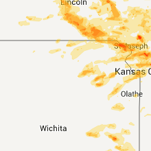
| 4:30 AM UTC | Quarter sized hail reported near Hiawatha, KS, 73.9 miles NE of Manhattan, KS |
| 4:35 AM UTC | Quarter sized hail reported near Robinson, KS, 69.7 miles NW of Kansas City, MO |
| 4:50 AM UTC | Tennis Ball sized hail reported near Highland, KS, 63.2 miles NW of Kansas City, MO, tennis ball sized hail reported on highway 36 one mile east of highland. |
| 5:07 AM UTC | Golf Ball sized hail reported near Troy, KS, 54.6 miles NNW of Kansas City, MO |
| 5:40 AM UTC | Quarter sized hail reported near Wamego, KS, 13.6 miles E of Manhattan, KS |
| 5:45 AM UTC | Quarter sized hail reported near Louisville, KS, 14.4 miles ENE of Manhattan, KS |
| 5:47 AM UTC | Quarter sized hail reported near Louisville, KS, 14.4 miles ENE of Manhattan, KS |
| 5:56 AM UTC | Quarter sized hail reported near Belvue, KS, 20.7 miles E of Manhattan, KS |
| 6:10 AM UTC | Half Dollar sized hail reported near Topeka, KS, 34 miles E of Manhattan, KS |
| 6:27 AM UTC | Quarter sized hail reported near Oskaloosa, KS, 43.5 miles W of Kansas City, MO |
| 6:32 AM UTC | Quarter sized hail reported near Topeka, KS, 49.2 miles ESE of Manhattan, KS |
| 6:41 AM UTC | Ping Pong Ball sized hail reported near McDonald's, KS, 43.8 miles NNW of Colby, KS |
| 8:00 AM UTC | Quarter sized hail reported near McDonald's, KS, 42 miles NNW of Colby, KS, received 0.90 inches of rainfall. estimated time of report from radar data. |
| 11:08 AM UTC | Quarter sized hail reported near Holton, KS, 48.4 miles ENE of Manhattan, KS |
North Dakota
| Local Time | Report Details |
|---|---|
| 2:40 PM UTC | Quarter sized hail reported near Kulm, ND, 62.2 miles NNW of Aberdeen, SD, pea to quarter sized hail lasted 5 minutes. |
| 1:36 AM UTC | Late repor in adams county ND, 104.9 miles WSW of Bismarck, ND |
South Dakota
| Local Time | Report Details |
|---|---|
| 2:48 PM UTC | Quarter sized hail reported near Pine Ridge, SD, 53.8 miles SE of Rapid City, SD |
| 2:48 PM UTC | Storm damage reported in shannon county SD, 53.8 miles SE of Rapid City, SD |
| 3:43 PM UTC | Storm damage reported in harding county SD, 106 miles N of Rapid City, SD |
| 7:33 PM UTC | Quarter sized hail reported near Hermosa, SD, 31.1 miles SE of Rapid City, SD |
| 8:44 PM UTC | Golf Ball sized hail reported near Rapid City, SD, 5.1 miles E of Rapid City, SD |
| 8:45 PM UTC | Quarter sized hail reported near Oelrichs, SD, 64.4 miles S of Rapid City, SD |
| 9:30 PM UTC | Storm damage reported in pennington county SD, 39.2 miles E of Rapid City, SD |
| 9:30 PM UTC | Quarter sized hail reported near Wasta, SD, 39.2 miles E of Rapid City, SD, 70 mph wind gusts |
| 9:45 PM UTC | Quarter sized hail reported near Wall, SD, 62.1 miles ENE of Rapid City, SD |
| 10:20 PM UTC | Quarter sized hail reported near Interior, SD, 66.6 miles ESE of Rapid City, SD, also had 50 mph winds |
| 10:35 PM UTC | Golf Ball sized hail reported near Oelrichs, SD, 72.7 miles S of Rapid City, SD |
| 11:30 PM UTC | Storm damage reported in fall river county SD, 68 miles SSW of Rapid City, SD |
| 11:50 PM UTC | Storm damage reported in fall river county SD, 53.3 miles SSW of Rapid City, SD |
Georgia
| Local Time | Report Details |
|---|---|
| 3:11 PM UTC | Half Dollar sized hail reported near Chickamauga, GA, 18.3 miles SSW of Chattanooga, TN, public reports quarter to half dollar sized hail at the pleasant grove baptist church. |
| 8:00 PM UTC | Tree blown down partially blocking prospect rd in franklin county GA, 52 miles SW of Greenville, SC |
| 8:08 PM UTC | Quarter sized hail reported near Register, GA, 48.3 miles WNW of Savannah, GA |
| 8:15 PM UTC | Tree down on ray weaver rd. time estimated from rada in hart county GA, 39.6 miles SSW of Greenville, SC |
| 8:41 PM UTC | One tree down blocking oc banks roa in bulloch county GA, 51.6 miles WNW of Savannah, GA |
| 9:05 PM UTC | Storm damage reported in chattooga county GA, 44.7 miles S of Chattanooga, TN |
| 9:09 PM UTC | 1 tree down on highway 114 in chattooga county GA, 44.9 miles S of Chattanooga, TN |
| 9:15 PM UTC | One tree down near the intersection of pond street and curahee roa in stephens county GA, 44.5 miles WSW of Greenville, SC |
| 9:15 PM UTC | One tree down near the intersection of coker road and race track roa in stephens county GA, 46.6 miles WSW of Greenville, SC |
| 9:19 PM UTC | 1 tree down on spring creek road in chattooga county GA, 34.9 miles S of Chattanooga, TN |
| 9:22 PM UTC | Irrigation pivot overturned and knocked into road near highway 33 north. mobile home in the same area knocked off its foundation with roof damag in colquitt county GA, 53.3 miles WSW of Douglas, GA |
| 9:29 PM UTC | 3 trees dow in floyd county GA, 45.8 miles S of Chattanooga, TN |
| 9:29 PM UTC | Power lines down on drexsel driv in floyd county GA, 53.6 miles S of Chattanooga, TN |
| 9:30 PM UTC | Several trees dow in colquitt county GA, 57.7 miles WSW of Douglas, GA |
| 9:30 PM UTC | One tree down partially blocking the roadway on holly springs road...heading toward silver shoals roa in stephens county GA, 37.3 miles WSW of Greenville, SC |
| 9:34 PM UTC | One tree down on ave in floyd county GA, 54.1 miles NW of Atlanta, GA |
| 9:35 PM UTC | Part of tin roof blown of outbuildin in floyd county GA, 55.3 miles S of Chattanooga, TN |
| 9:39 PM UTC | Tree and power lines down on greenridge driv in whitfield county GA, 27.5 miles SE of Chattanooga, TN |
| 9:40 PM UTC | Tree took down power lines on pine ridge driv in floyd county GA, 52 miles WNW of Atlanta, GA |
| 9:40 PM UTC | Power lines down on rockmart roa in floyd county GA, 53.2 miles NW of Atlanta, GA |
| 9:55 PM UTC | One tree dow in bartow county GA, 50.9 miles SSE of Chattanooga, TN |
| 9:55 PM UTC | 911 call center reported 2 trees down across piney bluff road in the northern portion of appling count in appling county GA, 37.8 miles NE of Douglas, GA |
| 10:08 PM UTC | 4 trees and 1 power line dow in murray county GA, 36.1 miles ESE of Chattanooga, TN |
| 10:10 PM UTC | Several trees down in the carrollton area. 20 trees down total across the northern 2/3rd of the county in carroll county GA, 41.4 miles WSW of Atlanta, GA |
| 10:15 PM UTC | 5 trees downed by strong winds in troup county GA, 26.5 miles NE of Auburn, AL |
| 10:15 PM UTC | Tree down on ray weaver rd. time estimated from rada in hart county GA, 39.6 miles SSW of Greenville, SC |
| 10:17 PM UTC | Large tree and powerlines down across ca in cherokee county GA, 43.8 miles NNW of Atlanta, GA |
| 10:17 PM UTC | One tree and one power line dow in cherokee county GA, 43.8 miles NNW of Atlanta, GA |
| 10:18 PM UTC | One tree down in cherokee county GA, 42.5 miles NNW of Atlanta, GA |
| 10:22 PM UTC | Several trees down in cherokee county GA, 42.5 miles NNW of Atlanta, GA |
| 10:23 PM UTC | Trees down on power lines. trees damaged a moving truc in cherokee county GA, 36.4 miles N of Atlanta, GA |
| 10:24 PM UTC | 3 to 4 trees down in ellija in gilmer county GA, 53.1 miles ESE of Chattanooga, TN |
| 10:24 PM UTC | Trees and power lines down on oak dale rd in cherokee county GA, 34.6 miles NNW of Atlanta, GA |
| 10:26 PM UTC | Trees down across riverston parkway. one tree landed on a ca in cherokee county GA, 35 miles N of Atlanta, GA |
| 10:29 PM UTC | Tree fell on a house in cherokee county GA, 34.4 miles N of Atlanta, GA |
| 10:29 PM UTC | Tree on a house in cherokee county GA, 34.4 miles N of Atlanta, GA |
| 10:30 PM UTC | Trees down county-wide. house had water damage caused by a tree falling on its roof in camill in mitchell county GA, 54.6 miles N of Tallahassee, FL |
| 10:30 PM UTC | Large tree blocking gault rd in cherokee county GA, 31.5 miles NNW of Atlanta, GA |
| 10:35 PM UTC | One downed tree caused damage to a house and truc in dekalb county GA, 11.1 miles NNE of Atlanta, GA |
| 10:35 PM UTC | Several trees down blocking state hwy 5 towards douglas county in carroll county GA, 32.3 miles WSW of Atlanta, GA |
| 10:35 PM UTC | Large tree down on n. victoria rd in cherokee county GA, 27.6 miles NNW of Atlanta, GA |
| 10:40 PM UTC | Quarter sized hail reported near Guyton, GA, 17.1 miles WNW of Savannah, GA, effingham county fire dept measured nickel and quarter size hail. |
| 10:42 PM UTC | Several trees down in the newnan area. 20 to 30 reports received across the count in coweta county GA, 35.2 miles SW of Atlanta, GA |
| 10:45 PM UTC | One tree down on new port road. knocked a power line dow in fannin county GA, 65.1 miles ESE of Chattanooga, TN |
| 10:46 PM UTC | Quarter sized hail reported near Guyton, GA, 25 miles NW of Savannah, GA, hail fell for 15 to 20 minutes |
| 10:55 PM UTC | 3 trees down and one power line downed across the lagrange area in troup county GA, 39.7 miles NE of Auburn, AL |
| 10:55 PM UTC | One tree down at intersection of robinson road and ebenezer roa in fayette county GA, 26.4 miles SSW of Atlanta, GA |
| 10:56 PM UTC | Few trees dow in meriwether county GA, 48.2 miles S of Atlanta, GA |
| 11:00 PM UTC | Tree down at tyrone palmetto roa in coweta county GA, 24.7 miles SW of Atlanta, GA |
| 11:00 PM UTC | Numerous trees down. additional details unavailable at tim in fayette county GA, 26.4 miles SSW of Atlanta, GA |
| 11:00 PM UTC | Barn destroyed and six trees downe in jackson county GA, 54.8 miles NE of Atlanta, GA |
| 11:05 PM UTC | 9-10 trees dow in forsyth county GA, 34.9 miles NNE of Atlanta, GA |
| 11:10 PM UTC | Quarter sized hail reported near Mauk, GA, 55.9 miles E of Auburn, AL |
| 11:15 PM UTC | More than a dozen trees down. details unavailble due to call volum in dekalb county GA, 11.1 miles NNE of Atlanta, GA |
| 11:19 PM UTC | Around a half dozen trees down across the western and central portions of the count in pike county GA, 44.7 miles S of Atlanta, GA |
| 11:20 PM UTC | Several trees down in mcdonough area in henry county GA, 24.8 miles SE of Atlanta, GA |
| 11:20 PM UTC | Two trees blown down...one taking down a power lin in dekalb county GA, 8.8 miles SE of Atlanta, GA |
| 11:36 PM UTC | Quarter sized hail reported near Bloomingdale, GA, 17.4 miles WNW of Savannah, GA, meldrim post office reported quarter size hail. |
| 11:42 PM UTC | A few trees dow in lamar county GA, 49.9 miles SSE of Atlanta, GA |
| 11:43 PM UTC | 3 tress dow in barrow county GA, 37 miles ENE of Atlanta, GA |
| 11:43 PM UTC | 8 trees dow in spalding county GA, 35.2 miles SSE of Atlanta, GA |
| 11:55 PM UTC | Storm damage reported in monroe county GA, 44.7 miles SSE of Atlanta, GA |
| 12:00 AM UTC | Several trees downed. 2-3 homes rcvd minor damage due to trees and limbs down. 3 power poles downe in taylor county GA, 76 miles E of Auburn, AL |
| 12:02 AM UTC | Several trees dow in bibb county GA, 76.8 miles SE of Atlanta, GA |
| 12:05 AM UTC | Tree down on power lines along page roa in bryan county GA, 27 miles WNW of Savannah, GA |
| 12:18 AM UTC | One tree down on cave springs rd in douglas county GA, 20.1 miles W of Atlanta, GA |
| 12:20 AM UTC | 911 call center reported 2 trees down on powerlines. relayed by local law enforcemen in wayne county GA, 55.9 miles WSW of Savannah, GA |
| 12:20 AM UTC | Golf Ball sized hail reported near Jesup, GA, 55.9 miles WSW of Savannah, GA, 911 call center reported half dollar size to golf ball size hail northwest of jesup. relayed by local law enforcement. |
| 12:21 AM UTC | Tree on house on ban in douglas county GA, 20.1 miles W of Atlanta, GA |
| 12:22 AM UTC | Tree on powr in douglas county GA, 22 miles WSW of Atlanta, GA |
| 12:23 AM UTC | 3 trees down near winston school in douglas county GA, 23.7 miles W of Atlanta, GA |
| 12:25 AM UTC | 2 trees down near fowler fiel in douglas county GA, 18.5 miles W of Atlanta, GA |
| 12:34 AM UTC | One tree dow in jasper county GA, 50.6 miles SE of Atlanta, GA |
| 12:39 AM UTC | Six to 12 trees down county wid in jones county GA, 65.5 miles SE of Atlanta, GA |
| 1:06 AM UTC | Local media relayed a report of one tree down along highway 261. time estimated by rada in long county GA, 49.9 miles WSW of Savannah, GA |
Nebraska
| Local Time | Report Details |
|---|---|
| 3:11 PM UTC | Half Dollar sized hail reported near Chadron, NE, 75.9 miles NNE of Scottsbluff, NE, some marble sized also. |
| 6:56 PM UTC | Golf Ball sized hail reported near Valentine, NE, 20.2 miles SW of Valentine, NE, reported by merritt trading post at merritt dam |
| 6:56 PM UTC | Hen Egg sized hail reported near Valentine, NE, 19.4 miles SW of Valentine, NE, public reported cracked windshields and plastic parts damage. |
| 7:10 PM UTC | 6 rural electric associaton power poles were blown down one half mile west of the valentine national wildlife refuge headquarters building. time of damage estimated at in cherry county NE, 20.8 miles SSW of Valentine, NE |
| 7:20 PM UTC | Public reported wind gust to 60 mph. measured with home weather statio in cherry county NE, 20.3 miles S of Valentine, NE |
| 7:53 PM UTC | Quarter sized hail reported near Wood Lake, NE, 32.1 miles SSE of Valentine, NE |
| 7:53 PM UTC | Wind speeds of 60 mph occurring along with nickel to quarter sized hail at time of this repor in cherry county NE, 32.1 miles SSE of Valentine, NE |
| 8:05 PM UTC | Golf Ball sized hail reported near Johnstown, NE, 31 miles SE of Valentine, NE, hail and high winds from 305 pm to 325 pm cdt caused crop and pasture damage at this location. report was furnished by an nerain observer. |
| 8:05 PM UTC | Golf Ball sized hail reported near Johnstown, NE, 53.2 miles SSE of Valentine, NE |
| 9:23 PM UTC | Spotter estimated 60 to 70 mph winds 6 miles south of atkinso in holt county NE, 17 miles W of Oneill, NE |
| 9:28 PM UTC | Baseball sized hail reported near Amelia, NE, 29.6 miles SW of Oneill, NE |
| 10:15 PM UTC | Herdco feed lot reported very strong winds along with hail as large as golf ball in wheeler county NE, 29.4 miles S of Oneill, NE |
| 10:15 PM UTC | Golf Ball sized hail reported near Burwell, NE, 29.4 miles S of Oneill, NE, mostly nickel sized hail but some hail was as large as golfballs. report was furnished by herdco feed lot. |
| 10:35 PM UTC | Estimated 60 to 70 mph wind gusts along with pebble sized hail and very heavy rai in holt county NE, 4.2 miles W of Oneill, NE |
| 10:40 PM UTC | Quarter sized hail reported near Spalding, NE, 48.4 miles SSE of Oneill, NE, mostly dime sized hail lasted for 5 minutes. |
| 10:40 PM UTC | Storm damage reported in wheeler county NE, 48.4 miles SSE of Oneill, NE |
| 10:45 PM UTC | Torrential rain with 50 to 60 mph wind in antelope county NE, 30.8 miles SE of Oneill, NE |
| 10:45 PM UTC | Quarter sized hail reported near Royal, NE, 28 miles ESE of Oneill, NE |
| 11:05 PM UTC | Storm damage reported in antelope county NE, 38.9 miles SE of Oneill, NE |
| 11:05 PM UTC | Quarter sized hail reported near Greeley, NE, 44.3 miles NNW of Grand Island, NE, also 30-40 mph winds and 0.76 inches of rain |
| 11:11 PM UTC | Golf Ball sized hail reported near Rushville, NE, 84 miles SSE of Rapid City, SD |
| 11:20 PM UTC | Quarter sized hail reported near , , 62.5 miles WNW of Omaha, NE, hail up to quarter size |
| 11:25 PM UTC | 4 inch diameter branches down. wind estimated up to 70 mp in madison county NE, 62.4 miles ESE of Oneill, NE |
| 11:35 PM UTC | 57 kt gust from asos at norfolk airport in madison county NE, 70.2 miles ESE of Oneill, NE |
| 11:35 PM UTC | Storm damage reported in madison county NE, 68.7 miles ESE of Oneill, NE |
| 11:35 PM UTC | 4 to 6 inch limbs blown down in stanton county NE, 81.3 miles ESE of Oneill, NE |
| 11:37 PM UTC | Ping Pong Ball sized hail reported near Rushville, NE, 89 miles NE of Scottsbluff, NE |
| 11:38 PM UTC | 80 mph gust from asos at norfolk airport in madison county NE, 70.2 miles ESE of Oneill, NE |
| 11:40 PM UTC | Large trees down and 6-8 inches of water over county road 51 in antelope county NE, 31.1 miles SE of Oneill, NE |
| 11:44 PM UTC | Quarter sized hail reported near Gordon, NE, 86.1 miles W of Valentine, NE |
| 11:44 PM UTC | Baseball sized hail reported near Hay Springs, NE, 84.6 miles NE of Scottsbluff, NE |
| 11:45 PM UTC | Near highway 81 and highway 20 junction in pierce county NE, 62.7 miles E of Oneill, NE |
| 11:45 PM UTC | Several large tree dow in antelope county NE, 47.8 miles SE of Oneill, NE |
| 11:46 PM UTC | Home damaged due to wind in stanton county NE, 73 miles ESE of Oneill, NE |
| 11:48 PM UTC | Winds estimated at least 60 mph...maybe mor in cedar county NE, 66.1 miles E of Oneill, NE |
| 11:55 PM UTC | Storm damage reported in cuming county NE, 74.8 miles NW of Omaha, NE |
| 11:56 PM UTC | Ping Pong Ball sized hail reported near West Point, NE, 56.5 miles NW of Omaha, NE, hail up to ping pong ball size |
| 12:03 AM UTC | Tree damage including large branches blown dow in dixon county NE, 85.3 miles E of Oneill, NE |
| 12:12 AM UTC | Small branches blown down in thurston county NE, 74.6 miles NNW of Omaha, NE |
| 12:23 AM UTC | Numerous 4 to 6 inch diameter branches downe in dixon county NE, 81.8 miles NNW of Omaha, NE |
| 12:35 AM UTC | Lots of blowing dus in scotts bluff county NE, 2.9 miles WSW of Scottsbluff, NE |
| 12:40 AM UTC | Quarter sized hail reported near Merriman, NE, 69.6 miles WSW of Valentine, NE |
| 12:40 AM UTC | Half Dollar sized hail reported near Merriman, NE, 75.5 miles WSW of Valentine, NE |
| 12:43 AM UTC | Storm damage reported in burt county NE, 38.7 miles NNW of Omaha, NE |
| 12:50 AM UTC | Estimated 50 to 60 mph wind gusts preceded the storm. nickle sized hail was observed at 702 pm md in banner county NE, 22.3 miles SW of Scottsbluff, NE |
| 12:50 AM UTC | Numerous 4 to 6 inch diameter branches downe in dixon county NE, 81.8 miles NNW of Omaha, NE |
| 1:11 AM UTC | Quarter sized hail reported near Seward, NE, 63.3 miles WSW of Omaha, NE, wind gust of 60 mph |
| 1:18 AM UTC | Quarter sized hail reported near Pleasant Dale, NE, 57.5 miles WSW of Omaha, NE |
| 1:33 AM UTC | Ping Pong Ball sized hail reported near Harrisburg, NE, 15 miles SSE of Scottsbluff, NE, small hail lasted from 733 pm until 743 pm mdt. the largest stones were up to walnut size. estimated wind gusts of at least 40 mph preceded the rain and hail. |
| 1:36 AM UTC | Golf Ball sized hail reported near Lincoln, NE, 49.6 miles SW of Omaha, NE |
| 1:37 AM UTC | Quarter sized hail reported near Merriman, NE, 69.6 miles WSW of Valentine, NE, quarter size hail continues. |
| 1:38 AM UTC | Golf Ball sized hail reported near Lincoln, NE, 49.6 miles SW of Omaha, NE |
| 1:38 AM UTC | Tree down at 48th and holdridge in lancaster county NE, 49.6 miles SW of Omaha, NE |
| 1:40 AM UTC | Half Dollar sized hail reported near Ellsworth, NE, 74.2 miles ENE of Scottsbluff, NE, most of the stones were much smaller. |
| 1:40 AM UTC | Ping Pong Ball sized hail reported near Lincoln, NE, 49.6 miles SW of Omaha, NE, 54th and knox st. |
| 1:44 AM UTC | Half Dollar sized hail reported near Crete, NE, 68.8 miles SW of Omaha, NE |
| 1:56 AM UTC | Golf Ball sized hail reported near Merriman, NE, 73.2 miles SW of Valentine, NE |
| 1:57 AM UTC | Golf Ball sized hail reported near Merriman, NE, 73.2 miles SW of Valentine, NE |
| 2:25 AM UTC | Golf Ball sized hail reported near Ashby, NE, 72.6 miles NW of North Platte, NE |
| 2:40 AM UTC | Quarter sized hail reported near Sterling, NE, 59.9 miles SSW of Omaha, NE |
| 2:47 AM UTC | Quarter sized hail reported near Mullen, NE, 62.7 miles SSW of Valentine, NE |
| 2:58 AM UTC | Ping Pong Ball sized hail reported near Steinauer, NE, 73.3 miles NNE of Manhattan, KS |
| 3:10 AM UTC | Tree branches down up to 5 inches in diameter. power outages in tecumse in johnson county NE, 62.8 miles SSW of Omaha, NE |
| 3:10 AM UTC | 2 large trees uprooted. small 10 x 10 garage demolishe in nemaha county NE, 65.7 miles S of Omaha, NE |
| 3:10 AM UTC | Quarter sized hail reported near Thedford, NE, 59.1 miles N of North Platte, NE |
| 3:11 AM UTC | Hen Egg sized hail reported near Burchard, NE, 68.3 miles N of Manhattan, KS |
| 3:26 AM UTC | Quarter sized hail reported near Pawnee City, NE, 67.9 miles NNE of Manhattan, KS |
| 3:35 AM UTC | Quarter sized hail reported near Humboldt, NE, 75.3 miles S of Omaha, NE |
| 4:00 AM UTC | Tree down across hwy 75 1/2 mile south of hwy 8 intersectio in richardson county NE, 71.1 miles NNE of Manhattan, KS |
| 4:00 AM UTC | Ping Pong Ball sized hail reported near Humboldt, NE, 72.8 miles NNE of Manhattan, KS |
| 11:36 PM CDT | Quarter sized hail reported near North Platte, NE, 0.6 miles SW of North Platte, NE, reported from knop tv. |
| 4:54 AM UTC | Quarter sized hail reported near Ord, NE, 54.2 miles NNW of Grand Island, NE |
| 11:57 PM CDT | Quarter sized hail reported near North Platte, NE, 0.6 miles SW of North Platte, NE |
| 4:59 AM UTC | Quarter sized hail reported near Ord, NE, 52.6 miles NNW of Grand Island, NE |
| 5:00 AM UTC | Windows blown out at the caseys gas station in town in valley county NE, 55.8 miles NNW of Grand Island, NE |
| 5:45 AM UTC | Quarter sized hail reported near Fullerton, NE, 35.7 miles NNE of Grand Island, NE |
| 6:45 AM UTC | Quarter sized hail reported near Lincoln, NE, 52.1 miles SW of Omaha, NE |
| 7:15 AM UTC | Quarter sized hail reported near Nehawka, NE, 29.8 miles S of Omaha, NE |
Missouri
| Local Time | Report Details |
|---|---|
| 4:30 PM UTC | Tree blocking us highway 6 in grundy county MO, 89.3 miles NE of Kansas City, MO |
| 7:05 PM UTC | Quarter sized hail reported near Norwood, MO, 49.1 miles E of Springfield, MO |
| 7:35 PM UTC | One barn destroyed and power lines dow in wright county MO, 54.9 miles SW of Salem, MO |
| 7:39 PM UTC | Quarter sized hail reported near Cabool, MO, 47.8 miles SW of Salem, MO, one inch hail reported at route 60 and route 181 intersection. |
| 7:40 PM UTC | Quarter sized hail reported near Cabool, MO, 47.3 miles SW of Salem, MO |
| 8:05 PM UTC | Half Dollar sized hail reported near Licking, MO, 25.1 miles WSW of Salem, MO, mixed quarter and half dollar sized hail reported. lightly covering groud. |
| 8:11 PM UTC | Quarter sized hail reported near Licking, MO, 24 miles WSW of Salem, MO |
| 9:15 PM UTC | Golf Ball sized hail reported near Cadet, MO, 48.5 miles SW of Saint Louis, MO |
| 9:19 PM UTC | Storm damage reported in washington county MO, 48.5 miles SW of Saint Louis, MO |
| 9:32 PM UTC | Ping Pong Ball sized hail reported near Cadet, MO, 51.4 miles SSW of Saint Louis, MO |
| 9:33 PM UTC | Quarter sized hail reported near De Soto, MO, 46.5 miles SSW of Saint Louis, MO |
| 9:40 PM UTC | Trees reported down in the communit in carter county MO, 52 miles SE of Salem, MO |
| 9:53 PM UTC | Hen Egg sized hail reported near Cadet, MO, 48.5 miles SW of Saint Louis, MO, shreading leaves off of trees. also rotating wall cloud passed directly overhead. this is second round of large hail spotter has received |
| 12:40 AM UTC | Half Dollar sized hail reported near Maryville, MO, 79.5 miles SE of Omaha, NE |
| 12:52 AM UTC | Golf Ball sized hail reported near Maryville, MO, 79.5 miles SE of Omaha, NE |
| 1:47 AM UTC | Quarter sized hail reported near Baring, MO, 28 miles WSW of Kahoka, MO, pea to quarter size hail and one inch of rain with the storm. |
| 2:30 AM UTC | Quarter sized hail reported near Lewistown, MO, 23.2 miles S of Kahoka, MO, quarter size hail just west southwest of monticello on highway 16 |
| 3:15 AM UTC | Tree blown down. time estimate in nodaway county MO, 66.8 miles SE of Omaha, NE |
| 3:19 AM UTC | Two to three inch tree limbs reported down with power outages in tow in atchison county MO, 63.8 miles SSE of Omaha, NE |
| 3:19 AM UTC | One large tree fell down on power line. power out in town. several large tree limbs also knocked down. thunderstorm wind gusts estimated up to 60 mp in atchison county MO, 63.8 miles SSE of Omaha, NE |
| 3:31 AM UTC | Also dime size hai in atchison county MO, 62.6 miles SSE of Omaha, NE |
| 3:31 AM UTC | Tree blown down on car. time estimate in nodaway county MO, 84.8 miles SE of Omaha, NE |
| 3:42 AM UTC | 6-10 inch tree limbs down at the intersection of hwy 129 and cc in putnam county MO, 65.2 miles W of Kahoka, MO |
| 3:52 AM UTC | 30 foot metal horse trailer blown over on its side. numerous large tree limbs down. thunderstorm wind gusts were estimated to 60 mp in nodaway county MO, 73.3 miles N of Kansas City, MO |
| 3:55 AM UTC | Tree limbs and power lines dow in harrison county MO, 78.3 miles SSW of Des Moines, IA |
| 3:55 AM UTC | Numerous branches down with thunderstorm wind gusts to 60 mp in gentry county MO, 77.1 miles N of Kansas City, MO |
| 3:58 AM UTC | 60 to 65 mph wind speed estimate in harrison county MO, 78.3 miles SSW of Des Moines, IA |
| 4:00 AM UTC | Power lines down in gentry county MO, 65.4 miles N of Kansas City, MO |
| 4:00 AM UTC | Trees and power lines dow in andrew county MO, 59.2 miles NNW of Kansas City, MO |
| 4:00 AM UTC | Trees and power lines dow in holt county MO, 78.4 miles SSE of Omaha, NE |
| 4:01 AM UTC | Quarter sized hail reported near Hatfield, MO, 78.3 miles SSW of Des Moines, IA, large hail falling concurrent with 60 to 65 mph winds. |
| 4:10 AM UTC | Large tree limbs dow in harrison county MO, 85.2 miles SSW of Des Moines, IA |
| 4:12 AM UTC | 60 mph wind speed...estimate in clinton county MO, 47.6 miles NNE of Kansas City, MO |
| 4:12 AM UTC | Power lines blown down in bethany. time estimate in harrison county MO, 85.7 miles NNE of Kansas City, MO |
| 4:12 AM UTC | Quarter sized hail reported near King City, MO, 65.4 miles N of Kansas City, MO |
| 4:20 AM UTC | Large tree limb down. power out in mill grov in mercer county MO, 87.6 miles S of Des Moines, IA |
| 4:25 AM UTC | Very heavy rain and pea-sized hail as wel in mercer county MO, 82.1 miles S of Des Moines, IA |
| 4:30 AM UTC | Tree blocking us highway 6 in grundy county MO, 89.3 miles NE of Kansas City, MO |
| 4:36 AM UTC | Trees and power lines down on tindall ave in trento in grundy county MO, 85.4 miles NE of Kansas City, MO |
| 4:41 AM UTC | Numerous trees down in gallatin. power is ou in daviess county MO, 64.9 miles NNE of Kansas City, MO |
| 4:45 AM UTC | Large tree fell and caused gas lea in dekalb county MO, 47.6 miles NNE of Kansas City, MO |
| 4:47 AM UTC | Large tree down in sullivan county MO, 86.9 miles WSW of Kahoka, MO |
| 4:50 AM UTC | Storm damage reported in grundy county MO, 87 miles NE of Kansas City, MO |
| 4:52 AM UTC | Storm damage reported in caldwell county MO, 53.7 miles NE of Kansas City, MO |
| 4:54 AM UTC | Storm damage reported in sullivan county MO, 75.5 miles W of Kahoka, MO |
| 4:55 AM UTC | Storm damage reported in adair county MO, 57.5 miles WSW of Kahoka, MO |
| 4:55 AM UTC | Numerous power lines down in livingston county MO, 72.8 miles NE of Kansas City, MO |
| 5:01 AM UTC | Emergency manager reports at cameron memorial airport wind damage of tied down airplane flipped over. numerous untied airplanes moved around no damage. rainfall amount in dekalb county MO, 47.6 miles NNE of Kansas City, MO |
| 5:03 AM UTC | Car blown off the road in old pattonsbur in daviess county MO, 69.5 miles NNE of Kansas City, MO |
| 5:04 AM UTC | Storm damage reported in linn county MO, 77.6 miles NW of Columbia, MO |
| 5:08 AM UTC | Storm damage reported in sullivan county MO, 75.5 miles W of Kahoka, MO |
| 5:10 AM UTC | Storm damage reported in adair county MO, 47.9 miles WSW of Kahoka, MO |
| 5:10 AM UTC | Numerous trees down and one structure damage in linn county MO, 62.4 miles NNW of Columbia, MO |
| 5:11 AM UTC | Highway 13 blocked by downed tre in daviess county MO, 68.3 miles NNE of Kansas City, MO |
| 5:15 AM UTC | Power poles blown down. time estimate in macon county MO, 65.3 miles SW of Kahoka, MO |
| 5:19 AM UTC | Possible funnel cloud also spotted at this locatio in macon county MO, 58.4 miles WSW of Kahoka, MO |
| 5:19 AM UTC | Multiple reports of power lines dow in adair county MO, 47.9 miles WSW of Kahoka, MO |
| 5:20 AM UTC | Car port damaged and multiple trees blown dow in macon county MO, 63.2 miles NNW of Columbia, MO |
| 5:22 AM UTC | Estimated gusts to 60 mp in livingston county MO, 72.8 miles NE of Kansas City, MO |
| 5:26 AM UTC | Thunderstorm wind gusts estimated up to 70 mph. also reported nickel sized hai in adair county MO, 43 miles WSW of Kahoka, MO |
| 5:27 AM UTC | Trees and power lines down countywide...between 1227 am and 1 a in knox county MO, 29.9 miles SW of Kahoka, MO |
| 5:30 AM UTC | Trees down in town. time estimate in scotland county MO, 23.9 miles W of Kahoka, MO |
| 5:30 AM UTC | High voltage power lines dow in linn county MO, 69.8 miles WSW of Kahoka, MO |
| 5:38 AM UTC | Thunderstorm wind gusts estimated up to 70 mph. electricity is out and branches are blown dow in randolph county MO, 32.8 miles N of Columbia, MO |
| 5:40 AM UTC | Up to three foot diameter trees downed in knox county MO, 29.4 miles SW of Kahoka, MO |
| 5:43 AM UTC | 3 ft diameter trees uprooted power lines down in shelby county MO, 51.7 miles N of Columbia, MO |
| 5:45 AM UTC | Trees...tree limbs and power lines down throughout town...from chiel of police in shelby county MO, 54.5 miles N of Columbia, MO |
| 5:45 AM UTC | Small building 15 ft up into a tree. 5 rec vehicles overturne in macon county MO, 56.4 miles NNW of Columbia, MO |
| 5:45 AM UTC | Part of roof blown off a house and shingles and sheeting blown of in macon county MO, 51.6 miles NNW of Columbia, MO |
| 5:46 AM UTC | Thunderstorm wind gusts estimated up to 70 mph. many tree branches down. swing set blown ove in macon county MO, 56.4 miles NNW of Columbia, MO |
| 5:55 AM UTC | Damage reported all across lewis county...large trees down...power lines down...mobile homes blown off foundation in lewis county MO, 24 miles SSW of Kahoka, MO |
| 5:55 AM UTC | Damage reported all across lewis county...large trees down...power lines down...several mobile homes destroyed...other structural damage countywid in lewis county MO, 24 miles SSW of Kahoka, MO |
| 5:55 AM UTC | Strong winds lasted for about 15 minutes. trees topped in yard...numerous large tree limbs blown down around town. small metal shed destroyed...one large limb through n in shelby county MO, 53.2 miles SSW of Kahoka, MO |
| 5:55 AM UTC | Two to three foot diameter trees uprooted in town...one two and a half foot diameter tree snapped off at bas in shelby county MO, 53.2 miles SSW of Kahoka, MO |
| 5:55 AM UTC | Three to five trees blown down in yard. one tree was at least 10 inches in diamete in shelby county MO, 52.6 miles NNE of Columbia, MO |
| 6:00 AM UTC | Several trees blown down in northwestern portions of count in boone county MO, 14.6 miles NNW of Columbia, MO |
| 6:03 AM UTC | Estimated 50-60 wind gusts...power is out as wel in lewis county MO, 24 miles SSW of Kahoka, MO |
| 6:07 AM UTC | 5-6 inch limbs down...quarter sized hai in lewis county MO, 24 miles SSW of Kahoka, MO |
| 6:07 AM UTC | Quarter sized hail reported near Lewistown, MO, 24 miles SSW of Kahoka, MO, 5-6 inch limbs down...quarter sized hail. |
| 6:07 AM UTC | Quarter sized hail reported near Holton, MO, 59.4 miles SSE of Omaha, NE, heavy rain is occurring with the hail. |
| 6:14 AM UTC | Roof partially blown off of a building near potterfield trucking on u.s. highway 24 36 eas in monroe county MO, 53.2 miles S of Kahoka, MO |
| 6:14 AM UTC | Several trees blown down on west side of tow in boone county MO, 0.9 miles W of Columbia, MO |
| 6:15 AM UTC | Several trees uprooted as well in lewis county MO, 28.1 miles SSE of Kahoka, MO |
| 6:20 AM UTC | Measured at lock and dam 20 in lewis county MO, 22.7 miles SSE of Kahoka, MO |
| 6:25 AM UTC | Several large trees blown down in tow in marion county MO, 44.1 miles SSE of Kahoka, MO |
| 6:27 AM UTC | Storm damage reported in marion county MO, 50.6 miles SSE of Kahoka, MO |
| 6:28 AM UTC | Storm damage reported in boone county MO, 10.4 miles SE of Columbia, MO |
| 6:28 AM UTC | Several trees blown down. one tree was blocking log providence road north of ashlan in boone county MO, 13.2 miles SSE of Columbia, MO |
| 6:30 AM UTC | Dime size hail...across the road from the airport in marion county MO, 52.2 miles SSE of Kahoka, MO |
| 6:30 AM UTC | Storm damage reported in pike county MO, 56.5 miles ENE of Columbia, MO |
| 6:30 AM UTC | Large tree damage reported all across the northern half of the county in pike county MO, 66.5 miles ENE of Columbia, MO |
| 6:30 AM UTC | Trees damaged and uprooted. time estimated from rada in ralls county MO, 63.2 miles NE of Columbia, MO |
| 1:42 AM CDT | Quarter sized hail reported near St Joseph, MO, 47.7 miles NNW of Kansas City, MO |
| 7:00 AM UTC | Power lines down...wright city also in warren county MO, 51.8 miles WNW of Saint Louis, MO |
| 7:00 AM UTC | A large tree was blown over onto a car on roosevelt avenu in warren county MO, 52.5 miles WNW of Saint Louis, MO |
| 7:15 AM UTC | Up to 3 inch diameter branches snapped off trees. large trash dumpsters blown out onto the street in montgomery county MO, 44.4 miles E of Columbia, MO |
| 7:16 AM UTC | Storm damage reported in franklin county MO, 55.2 miles W of Saint Louis, MO |
| 7:22 AM UTC | Storm damage reported in gasconade county MO, 57.3 miles SE of Columbia, MO |
| 7:25 AM UTC | Ping Pong Ball sized hail reported near Carrollton, MO, 60.8 miles ENE of Kansas City, MO |
| 7:32 AM UTC | Up to 3 inch diameter branches snapped off trees. large trash dumpsters blown out onto the street in montgomery county MO, 44.4 miles E of Columbia, MO |
| 7:33 AM UTC | Storm damage reported in gasconade county MO, 57.3 miles SE of Columbia, MO |
| 7:39 AM UTC | Storm damage reported in jefferson county MO, 18.5 miles WSW of Saint Louis, MO |
| 7:42 AM UTC | Storm damage reported in franklin county MO, 34.9 miles WSW of Saint Louis, MO |
| 7:42 AM UTC | Quarter sized hail reported near Gray Summit, MO, 34.9 miles WSW of Saint Louis, MO |
| 10:15 AM UTC | Multiple large tree limbs down near n indiana and ne antioch rd. estimated gust 60 mp in clay county MO, 8.4 miles NNE of Kansas City, MO |
| 10:30 AM UTC | Tree fell onto a home. numerous large limbs dow in jackson county MO, 8.8 miles ESE of Kansas City, MO |
| 10:35 AM UTC | Large tree down on home at 35th and woodland in jackson county MO, 3.2 miles SSE of Kansas City, MO |
Tennessee
| Local Time | Report Details |
|---|---|
| 5:30 PM UTC | Reported tree down close to proximity to home and vehicle in town cente in chester county TN, 48.3 miles S of Mc Kenzie, TN |
| 6:04 PM UTC | An eight inch tree top was broken off and fell onto a city street in lawrenceburg blocking that roadway. a 53 mph wind gust was measured at the 911 center in lawrencebu in lawrence county TN, 36.4 miles NNE of Florence, AL |
| 6:25 PM UTC | Several trees and construction signs were blown over. the roof of a pharmacy was damaged. another building had part of its roof ben in hardin county TN, 43.2 miles NW of Florence, AL |
| 6:25 PM UTC | Power lines were downed on evans road in the fivepoints area three miles north of the state line off of state route 9 in lawrence county TN, 26.7 miles NE of Florence, AL |
| 6:30 PM UTC | Reported trees dow in chester county TN, 48.3 miles S of Mc Kenzie, TN |
| 6:50 PM UTC | A couple of trees fell on a power pol in hardin county TN, 36.9 miles WNW of Florence, AL |
| 7:05 PM UTC | A tree was knocked down onto power lines at a residence on crestview driv in franklin county TN, 46.1 miles W of Chattanooga, TN |
Alabama
| Local Time | Report Details |
|---|---|
| 6:45 PM UTC | Trees were knocked down on henry road. time and location estimate in limestone county AL, 26.5 miles E of Florence, AL |
| 6:50 PM UTC | Trees were knocked down onto river rose trail. time and location estimate in colbert county AL, 21.4 miles W of Florence, AL |
| 6:50 PM UTC | Trees were knocked down onto mount hester road. time and location estimate in colbert county AL, 20.8 miles WSW of Florence, AL |
| 6:55 PM UTC | Trees in lauderdale county AL, 13.5 miles NW of Florence, AL |
| 6:55 PM UTC | Trees in lauderdale county AL, 9.7 miles WNW of Florence, AL |
| 6:55 PM UTC | Trees in lauderdale county AL, 13.3 miles NW of Florence, AL |
| 6:55 PM UTC | Trees in lauderdale county AL, 19.2 miles E of Florence, AL |
| 6:55 PM UTC | Trees were knocked down onto cottontown hill road. time and location estimate in colbert county AL, 14.7 miles SE of Florence, AL |
| 7:06 PM UTC | Tree down in lauderdale county AL, 1.4 miles E of Florence, AL |
| 7:10 PM UTC | Snapped power pole in madison county AL, 55 miles E of Florence, AL |
| 7:14 PM UTC | Trees down in saragoss in walker county AL, 42.8 miles NW of Birmingham, AL |
| 7:15 PM UTC | Power outages due to trees on power lines in morgan county AL, 43.3 miles SE of Florence, AL |
| 7:15 PM UTC | Power outages due to trees on power lines in cullman county AL, 37.3 miles N of Birmingham, AL |
| 7:15 PM UTC | Power outages due to trees on power lines in morgan county AL, 42.2 miles ESE of Florence, AL |
| 7:15 PM UTC | Trees on power lines in madison county AL, 61.8 miles E of Florence, AL |
| 7:15 PM UTC | Trees on power lines in madison county AL, 59.7 miles E of Florence, AL |
| 7:15 PM UTC | Trees were knocked down onto county road 175. time and location estimated. power outages in the are in franklin county AL, 21.5 miles S of Florence, AL |
| 7:20 PM UTC | Trees were knocked down along state highway 243. time and location estimated. power outages in the are in franklin county AL, 28.3 miles S of Florence, AL |
| 7:20 PM UTC | Trees were knocked down onto county road 75. time and location estimated. power outages in the are in franklin county AL, 25.6 miles S of Florence, AL |
| 7:23 PM UTC | Trees were knocked onto power lines along county road 221. time and location estimate in lawrence county AL, 35 miles SE of Florence, AL |
| 7:25 PM UTC | Trees were knocked down onto county road 81. time and location estimated. power outages in the are in franklin county AL, 28.5 miles S of Florence, AL |
| 7:25 PM UTC | Trees were knocked down onto county road 87. time and location estimate in lawrence county AL, 34.5 miles SE of Florence, AL |
| 7:28 PM UTC | Trees down in lawrence county AL, 22.7 miles ESE of Florence, AL |
| 7:28 PM UTC | Trees down in lawrence county AL, 32.3 miles SE of Florence, AL |
| 7:28 PM UTC | Trees were knocked down onto county road 334. time and location estimate in lawrence county AL, 35.8 miles SE of Florence, AL |
| 7:28 PM UTC | Trees down in lawrence county AL, 33.7 miles ESE of Florence, AL |
| 7:30 PM UTC | Trees down. downed tree and power line pole blocking roa in houston county AL, 76.4 miles NE of Miramar Beach, FL |
| 7:30 PM UTC | Trees were knocked down onto county road 59. time and location estimated. power outages in the are in franklin county AL, 29.5 miles S of Florence, AL |
| 7:30 PM UTC | Trees were knocked down onto county road 184. time and location estimate in lawrence county AL, 35.9 miles SE of Florence, AL |
| 7:32 PM UTC | Broken limbs and trees down in morgan county AL, 35.8 miles ESE of Florence, AL |
| 7:32 PM UTC | Broken limbs and trees down in morgan county AL, 40.9 miles ESE of Florence, AL |
| 8:00 PM UTC | Trees down in marshall county AL, 61.6 miles NE of Birmingham, AL |
| 8:00 PM UTC | Trees down in marshall county AL, 64.8 miles NNE of Birmingham, AL |
| 8:00 PM UTC | Several trees were knocked down. two homes lost metal porch in cullman county AL, 54.7 miles NNE of Birmingham, AL |
| 8:00 PM UTC | Several trees were knocked down. two homes lost metal porch in cullman county AL, 55.3 miles NNE of Birmingham, AL |
| 8:00 PM UTC | Trees down in marshall county AL, 62.3 miles NE of Birmingham, AL |
| 8:00 PM UTC | Several trees were knocked down. two homes lost metal porch in blount county AL, 53.4 miles NNE of Birmingham, AL |
| 8:10 PM UTC | Canopy was ripped and destroyed from homeowners backyard in jaspe in walker county AL, 34.8 miles NW of Birmingham, AL |
| 8:14 PM UTC | Trees down in saragoss in walker county AL, 42.8 miles NW of Birmingham, AL |
| 8:20 PM UTC | Tree on a house in cullman county AL, 39.3 miles NNW of Birmingham, AL |
| 8:20 PM UTC | Tree on a house on the 300 block of county road 33 in cullman county AL, 39.3 miles NNW of Birmingham, AL |
| 8:20 PM UTC | Barn destroyed and blown into the road at the 6400 block of county road 43 in cullman county AL, 41.4 miles N of Birmingham, AL |
| 8:20 PM UTC | Barn in road in cullman county AL, 41.4 miles N of Birmingham, AL |
| 8:28 PM UTC | Small broken tree limbs in dekalb county AL, 49.2 miles SW of Chattanooga, TN |
| 8:30 PM UTC | Emergency manager reports several trees and power lines down in the northern and western parts of the count in blount county AL, 33.2 miles NNE of Birmingham, AL |
| 8:30 PM UTC | Tree down on broadway street in sardis cit in etowah county AL, 59.9 miles NE of Birmingham, AL |
| 8:38 PM UTC | Trees down in marshall county AL, 59.6 miles NE of Birmingham, AL |
| 8:42 PM UTC | Tree down at gallant road and country hill road in gallan in etowah county AL, 46.2 miles NE of Birmingham, AL |
| 8:48 PM UTC | Tree down at gallant road and country hill road in gallan in etowah county AL, 46.2 miles NE of Birmingham, AL |
| 8:55 PM UTC | Storm damage reported in cherokee county AL, 59.3 miles SSW of Chattanooga, TN |
| 8:55 PM UTC | Trees and power lines down at county road 75 and 144 in cedar bluf in cherokee county AL, 59.3 miles SSW of Chattanooga, TN |
| 8:59 PM UTC | Tree down across county road 131 in cedar bluf in cherokee county AL, 59.3 miles SSW of Chattanooga, TN |
| 9:09 PM UTC | Tree down across highway 68 east and highway 176 in sand roc in cherokee county AL, 61.5 miles SSW of Chattanooga, TN |
| 9:10 PM UTC | Shingles off a roof and tree limbs dow in st. clair county AL, 41.8 miles ENE of Birmingham, AL |
| 9:10 PM UTC | Powerlines down on lakeshore just west of green springs highwa in jefferson county AL, 4.9 miles S of Birmingham, AL |
| 9:10 PM UTC | Quarter sized hail reported near Weaver, AL, 59.5 miles ENE of Birmingham, AL, marble to quarter size hail. |
| 9:16 PM UTC | Tree down across highway 3 in cherokee county AL, 55.4 miles SSW of Chattanooga, TN |
| 9:20 PM UTC | Tree down across highway 68 east near county road 15 in cherokee county AL, 62.2 miles SSW of Chattanooga, TN |
| 9:20 PM UTC | Power line down and smokin in st. clair county AL, 34 miles ENE of Birmingham, AL |
| 9:28 PM UTC | Power lines down in the city of talladeg in talladega county AL, 41.6 miles E of Birmingham, AL |
| 9:29 PM UTC | Quarter sized hail reported near Chelsea, AL, 16.4 miles SE of Birmingham, AL, quarter size hail in the city of chelsea. |
| 9:30 PM UTC | Quarter sized hail reported near Perote, AL, 44.3 miles SSW of Auburn, AL, quarter size hail reported. |
| 9:51 PM UTC | Trees down at the intersection of highway 25 and county road 30 in shelby county AL, 27 miles SSE of Birmingham, AL |
| 9:57 PM UTC | Trees down at the intersection of narrows parkway and old highway 28 in shelby county AL, 13.6 miles SE of Birmingham, AL |
| 10:20 PM UTC | Trees down in several locations in the city of valley in chambers county AL, 22.9 miles NE of Auburn, AL |
| 10:44 PM UTC | Trees down around tow in elmore county AL, 53.6 miles W of Auburn, AL |
| 11:34 PM UTC | Trees down across the city of opelika...numerous location in lee county AL, 6.6 miles ENE of Auburn, AL |
South Carolina
| Local Time | Report Details |
|---|---|
| 8:04 PM UTC | Trees down along interstate 95 near exit 59. time estimated based on rada in colleton county SC, 41.6 miles WSW of Charleston, SC |
| 8:41 PM UTC | One tree down along mighty cougar driv in colleton county SC, 40.5 miles WSW of Charleston, SC |
| 9:30 PM UTC | One small tree down at coneross campground and some campers reported awning damag in oconee county SC, 22.9 miles SW of Greenville, SC |
| 9:32 PM UTC | Tree down blocking pine grove rd in oconee county SC, 26.8 miles SW of Greenville, SC |
| 9:38 PM UTC | Several trees and large branches down near the intersection of orchard road and mewville roa in colleton county SC, 51.7 miles WSW of Charleston, SC |
| 9:42 PM UTC | Tree debris with large limbs down along exit 41 off interstate 9 in colleton county SC, 51.1 miles NNE of Savannah, GA |
| 9:45 PM UTC | Large tree blown down across the road near the intersection of ritter road and bluehouse road. time estimated based on rada in colleton county SC, 49.6 miles SW of Charleston, SC |
| 10:00 PM UTC | 1 foot diameter tree limb fell on a pickup truck. picture sent in by trained spotte in colleton county SC, 51.7 miles NNE of Savannah, GA |
Florida
| Local Time | Report Details |
|---|---|
| 8:05 PM UTC | Large tree reported down on two car in leon county FL, 6 miles NE of Tallahassee, FL |
| 8:05 PM UTC | Several trees reported down with power outage in leon county FL, 6 miles NE of Tallahassee, FL |
| 8:05 PM UTC | Tree limbs down and nickel size hai in leon county FL, 6 miles NE of Tallahassee, FL |
| 8:15 PM UTC | 4 wsw holly hill tree down at intersection of lpga williamson blvds. estimated tree size 8-12 inches blocking 1 west bound lane on lpga blv in volusia county FL, 50.1 miles NNE of Orlando, FL |
| 8:20 PM UTC | Numerous trees down across the city of tallahassee including on centerville road...chaires road...buck lake road...and old bainbridge roa in leon county FL, 0 miles ENE of Tallahassee, FL |
| 8:42 PM UTC | 911 call center reported several trees down in the eastern portions of the county. time is estimated and based on radar imager in hamilton county FL, 65.6 miles W of Jacksonville, FL |
| 9:02 PM UTC | Quarter sized hail reported near Ponce de Leon, FL, 32.7 miles NE of Miramar Beach, FL, quarter size hail and estimated 45 mph winds. |
| 9:30 PM UTC | 911 call center reported several trees down in the western portion of the county near jasper. time is estimated and based on radar imager in hamilton county FL, 68.2 miles S of Douglas, GA |
| 9:40 PM UTC | Quarter sized hail reported near Defuniak Springs, FL, 27.5 miles NNE of Miramar Beach, FL, quarter size hail and estimated wind gust to 50 mph |
| 9:45 PM UTC | 911 call center reports 5 trees down on powerlines on state road 121 and lake hampton road northwest of hilliard. time is estimated based on radar imager in nassau county FL, 33.2 miles NNW of Jacksonville, FL |
| 10:00 PM UTC | Pine trees snapped off and damage to structures near county road 417 and interstate 1 in suwannee county FL, 74.4 miles W of Jacksonville, FL |
North Carolina
| Local Time | Report Details |
|---|---|
| 11:26 PM UTC | Several trees down in rutherford county NC, 54.3 miles NE of Greenville, SC |
| 12:20 AM UTC | Multiple trees reported down in the forest city area. trees also reported down on either side of hwy 221 south of rutherfordton. time estimated from rada in rutherford county NC, 54.3 miles NE of Greenville, SC |
Wyoming
| Local Time | Report Details |
|---|---|
| 12:02 AM UTC | Torrington airport measured a wind gust to 60 mph. sustained winds were recorded at 44 mp in goshen county WY, 30.3 miles WNW of Scottsbluff, NE |
Illinois
| Local Time | Report Details |
|---|---|
| 3:42 AM UTC | Small tree brancehs down. corn stalks snapped near the groun in warren county IL, 50.3 miles WNW of Peoria, IL |
| 4:06 AM UTC | Storm damage reported in peoria county IL, 4.8 miles W of Peoria, IL |
| 4:35 AM UTC | Quarter sized hail reported near Armington, IL, 28.4 miles SSE of Peoria, IL, hail fell for 5 minutes |
| 5:05 AM UTC | Storm damage reported in logan county IL, 52.8 miles NW of Mattoon, IL |
| 5:05 AM UTC | Golf Ball sized hail reported near Latham, IL, 52.8 miles NW of Mattoon, IL |
| 6:25 AM UTC | Several trees downed and power out in adams county IL, 33.3 miles SE of Kahoka, MO |
| 6:30 AM UTC | 60-70 mph estimated wind gusts...power is ou in adams county IL, 38.1 miles SSE of Kahoka, MO |
| 6:30 AM UTC | 8-12 inch tree limbs down in adams county IL, 38.1 miles SSE of Kahoka, MO |
| 6:30 AM UTC | Several large trees blown down as well as power line in adams county IL, 38.1 miles SSE of Kahoka, MO |
| 6:33 AM UTC | Storm damage reported in adams county IL, 48.6 miles SSE of Kahoka, MO |
| 6:35 AM UTC | Storm damage reported in adams county IL, 43.1 miles SE of Kahoka, MO |
| 6:35 AM UTC | Numerous trees down in town...power out in adams county IL, 40 miles SE of Kahoka, MO |
| 6:35 AM UTC | Trees and tree limbs down...pine tree snapped in adams county IL, 48.6 miles SSE of Kahoka, MO |
| 6:36 AM UTC | Estimated 60-70 mph wind gusts in adams county IL, 32.3 miles SE of Kahoka, MO |
| 6:37 AM UTC | 60-70 mph estimated wind gusts...power is ou in adams county IL, 38.1 miles SSE of Kahoka, MO |
| 6:38 AM UTC | Tree limbs and powerlines dow in hancock county IL, 16 miles ESE of Kahoka, MO |
| 6:38 AM UTC | Quarter sized hail reported near Warsaw, IL, 16 miles ESE of Kahoka, MO |
| 6:41 AM UTC | 8-12 inch tree limbs down in adams county IL, 38.1 miles SSE of Kahoka, MO |
| 6:43 AM UTC | Estimated 60-70 mph wind gusts in adams county IL, 32.3 miles SE of Kahoka, MO |
| 6:44 AM UTC | Also observing powerline flashes on east side of carthag in hancock county IL, 31.6 miles E of Kahoka, MO |
| 6:45 AM UTC | Winds in excess of 70 mph blew down several trees and large limbs in bentley. some roads were blocked. some buildings and homes were also damaged. a new morton building in hancock county IL, 32.6 miles E of Kahoka, MO |
| 6:45 AM UTC | Numerous trees and power lines downe in adams county IL, 48.6 miles SSE of Kahoka, MO |
| 6:45 AM UTC | Several trees and limbs blown dow in hancock county IL, 30.6 miles E of Kahoka, MO |
| 6:45 AM UTC | Some buildings blown down between carthage and bentley. second hand report. time estimate in hancock county IL, 31.1 miles E of Kahoka, MO |
| 6:46 AM UTC | Estimated 65 to 70 mph wind. power is out in bowen and also in augusta. time was estimate in hancock county IL, 37.2 miles ESE of Kahoka, MO |
| 6:46 AM UTC | Numerous trees and power lines down. time of damage estimate in hancock county IL, 43.2 miles ESE of Kahoka, MO |
| 7:05 AM UTC | One foot diameter tree limb blown out of a large pecan tre in pike county IL, 71.7 miles SE of Kahoka, MO |
| 7:15 AM UTC | 20 inch diameter trunk/18 foot tall tree uprooted in colchester. time estimated on delayed repor in mcdonough county IL, 49 miles E of Kahoka, MO |
| 7:20 AM UTC | 18 inch diameter tree snapped off at base...downed powerlines and power out in town of colcheste in mcdonough county IL, 49 miles E of Kahoka, MO |
| 7:30 AM UTC | Relayed from isp scanner traffic...power poles down south of jerseyville on us hwy 67 near crystal lake road in jersey county IL, 34.7 miles NNW of Saint Louis, MO |
| 7:30 AM UTC | Mobile home walls blown down and out. trees and powerlines dow in morgan county IL, 66.5 miles SSW of Peoria, IL |
| 7:30 AM UTC | Several fir trees blown down in macomb. delayed repor in mcdonough county IL, 54.9 miles E of Kahoka, MO |
| 7:45 AM UTC | Observer is seeing power flashes in madison county IL, 19 miles N of Saint Louis, MO |
| 7:52 AM UTC | Storm damage reported in fulton county IL, 29.5 miles SW of Peoria, IL |
| 7:53 AM UTC | Tree split in two...landing on power lines in fulton county IL, 49.1 miles WSW of Peoria, IL |
| 7:55 AM UTC | Delayed report. trees down in town. time estimate in menard county IL, 49.1 miles SSW of Peoria, IL |
| 8:28 AM UTC | Storm damage reported in tazewell county IL, 5.3 miles SE of Peoria, IL |
| 9:27 AM UTC | Tree down near intersection of us-40 and county road 1000 in effingham county IL, 30.2 miles SSW of Mattoon, IL |
Minnesota
| Local Time | Report Details |
|---|---|
| 10:30 AM UTC | Quarter sized hail reported near Parkers Prairie, MN, 84.7 miles NNE of Montevideo, MN |
Connect with Interactive Hail Maps