

Hail Map for Thursday, March 14, 2019

Number of Impacted Households on 3/14/2019
0
Impacted by 1" or Larger Hail
0
Impacted by 1.75" or Larger Hail
0
Impacted by 2.5" or Larger Hail
Square Miles of Populated Area Impacted on 3/14/2019
0
Impacted by 1" or Larger Hail
0
Impacted by 1.75" or Larger Hail
0
Impacted by 2.5" or Larger Hail


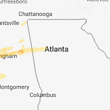


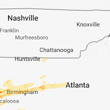


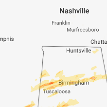
Cities Most Affected by Hail Storms of 3/14/2019
| Hail Size | Demographics of Zip Codes Affected | ||||||
|---|---|---|---|---|---|---|---|
| City | Count | Average | Largest | Pop Density | House Value | Income | Age |
| Wanatah, IN | 1 | 1.75 | 1.75 | 49 | $102k | $54.1k | 40.6 |
| La Grange, KY | 1 | 1.75 | 1.75 | 294 | $140k | $54.9k | 38.5 |
| Fayette, AL | 1 | 1.75 | 1.75 | 31 | $65k | $28.6k | 42.9 |
| La Porte, IN | 1 | 1.75 | 1.75 | 229 | $101k | $44.6k | 40.2 |
Hail and Wind Damage Spotted on 3/14/2019
Filter by Report Type:Hail ReportsWind Reports
States Impacted
Missouri, Indiana, Illinois, Kentucky, Mississippi, Alabama, Michigan, Ohio, GeorgiaMissouri
| Local Time | Report Details |
|---|---|
| 8:02 AM CDT | Corrects previous tstm wnd dmg report from 1 n pinhook. barn destroyed near intersection of ff highway and aa highwa in mississippi county MO, 40.6 miles SSE of Cape Girardeau, MO |
| 9:02 AM CDT | Barn destroyed near intersection of ff highway and aa highwa in mississippi county MO, 40.6 miles SSE of Cape Girardeau, MO |
| 1:12 PM CDT | Several temporary sanitation facilities blown over near planned site for st. patricks day festivities in cottlevill in st. charles county MO, 25.5 miles WNW of Saint Louis, MO |
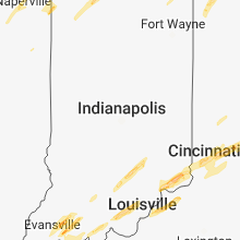
Indiana
| Local Time | Report Details |
|---|---|
| 10:30 AM CDT | Several large limbs down in owensvill in gibson county IN, 21.3 miles NNW of Evansville, IN |
| 11:29 AM CDT | Quarter sized hail reported near Evansville, IN, 5.3 miles NE of Evansville, IN, quarter-size hail reported on the northwest side of evansville. |
| 11:50 AM CDT | Utility pole downed at the 1700 block of taylor avenu in vanderburgh county IN, 2.2 miles ESE of Evansville, IN |
| 1:01 PM EDT | Quarter sized hail reported near Stendal, IN, 32 miles NE of Evansville, IN |
| 1:09 PM EDT | Quarter sized hail reported near Jasper, IN, 42.8 miles NE of Evansville, IN, reported at ireland... in. |
| 12:25 PM CDT | Estimated 60-70 mph gusts with tree damage. time estimate in warrick county IN, 8.6 miles ESE of Evansville, IN |
| 1:27 PM EDT | Tree across road 231 north of haysvill in dubois county IN, 50.2 miles NE of Evansville, IN |
| 1:27 PM EDT | Trees down east of huntingburg... i in dubois county IN, 41.6 miles ENE of Evansville, IN |
| 1:27 PM EDT | Telephone lines down 2 miles west of huntingbur in dubois county IN, 38 miles NE of Evansville, IN |
| 2:12 PM EDT | Trees and a few power lines down in northwest corner of washington county. time approximation from rada in washington county IN, 58 miles NNW of Louisville, KY |
| 2:25 PM EDT | Possible tornado damage. debris across propert in jackson county IN, 57.4 miles S of Indianapolis, IN |
| 2:25 PM EDT | Quarter sized hail reported near Brownstown, IN, 61.4 miles S of Indianapolis, IN, relayed via social media. |
| 1:49 PM CDT | Quarter sized hail reported near Dyer, IN, 27.3 miles SSE of Chicago, IL |
| 1:49 PM CDT | Ping Pong Ball sized hail reported near Dyer, IN, 27.3 miles SSE of Chicago, IL, corrects previous hail report from dyer. |
| 1:51 PM CDT | Funnel cloud was reported. seven power lines down... as well as several pine trees which are 30-40 feet tall and 1-2 ft in diameter. light roof damage to a barn and far in lake county IN, 43.9 miles SSE of Chicago, IL |
| 1:53 PM CDT | Quarter sized hail reported near Hammond, IN, 22.1 miles SSE of Chicago, IL, estimated 60 mph winds too. |
| 1:53 PM CDT | Quarter sized hail reported near Lowell, IN, 44.7 miles SSE of Chicago, IL |
| 2:00 PM CDT | Multiple trees reported down across the county... including in tell city and bristow. time approximat in perry county IN, 47 miles E of Evansville, IN |
| 2:03 PM CDT | Multiple trees down...reported at tell city i in perry county IN, 43.4 miles E of Evansville, IN |
| 2:21 PM CDT | Quarter sized hail reported near Valparaiso, IN, 47.2 miles SE of Chicago, IL, estimated 60 mph winds. |
| 2:35 PM CDT | Golf Ball sized hail reported near Wanatah, IN, 49.2 miles SE of Chicago, IL, picture posted on twitter of golf ball size hail. |
| 3:37 PM EDT | Half Dollar sized hail reported near Ramsey, IN, 33.3 miles NW of Louisville, KY, reported at ramsey... indiana. |
| 3:38 PM EDT | Roof of covered bridge collapsed near holton. time estimated from rada in ripley county IN, 48.2 miles W of Cincinnati, OH |
| 3:40 PM EDT | Ping Pong Ball sized hail reported near New Salisbury, IN, 31 miles NW of Louisville, KY, quarter to golf ball size hail. |
| 3:43 PM EDT | Tree down...reported at hardy lake scott county indian in scott county IN, 55.3 miles N of Louisville, KY |
| 3:50 PM EDT | Tree down...reported at wetzel drive and west st harrisson county indian in harrison county IN, 36.2 miles NW of Louisville, KY |
| 2:54 PM CDT | Storm damage reported in la porte county IN, 52.8 miles ESE of Chicago, IL |
| 2:54 PM CDT | Half Dollar sized hail reported near La Porte, IN, 52.8 miles ESE of Chicago, IL |
| 2:58 PM CDT | Golf Ball sized hail reported near La Porte, IN, 52.9 miles ESE of Chicago, IL, brief period of hail with a few reaching golf ball size. |
| 3:59 PM EDT | Quarter sized hail reported near New Carlisle, IN, 59.2 miles ESE of Chicago, IL, picture shared on twitter by abc 57. |
| 4:04 PM EDT | Quarter sized hail reported near Otisco, IN, 38.2 miles N of Louisville, KY, reported at otisco... in. |
| 4:07 PM EDT | Tree dow in clark county IN, 41.1 miles N of Louisville, KY |
| 3:11 PM CDT | Quarter sized hail reported near New Carlisle, IN, 58.2 miles ESE of Chicago, IL, picture shared on twitter by wsbt. |
| 5:42 PM EDT | Corrects previous tstm wnd gst report from 3 nw south bend. wind gust recorded at goshen airpor in elkhart county IN, 47.3 miles NW of Fort Wayne, IN |
| 5:42 PM EDT | Wind gust recorded at south bend regional airpor in st. joseph county IN, 69.3 miles E of Chicago, IL |
| 6:15 PM EDT | Quarter sized hail reported near Hudson, IN, 35.6 miles N of Fort Wayne, IN |
| 6:20 PM EDT | Quarter sized hail reported near Angola, IN, 39.8 miles N of Fort Wayne, IN |
Illinois
| Local Time | Report Details |
|---|---|
| 11:00 AM CDT | Multiple tree branches down (3-6 inch diameter) in calumet heights neighborhood of chicag in cook county IL, 11 miles SSE of Chicago, IL |
| 11:30 AM CDT | Large tree down and additional power lines reported down in the cit in tazewell county IL, 8.7 miles SSW of Peoria, IL |
| 11:40 AM CDT | Quarter sized hail reported near Mazon, IL, 59.2 miles SW of Chicago, IL |
| 12:07 PM CDT | Quarter sized hail reported near Shorewood, IL, 39.8 miles SW of Chicago, IL |
| 12:07 PM CDT | Quarter sized hail reported near Shorewood, IL, 40.3 miles SW of Chicago, IL |
| 12:21 PM CDT | Storm damage reported in mclean county IL, 35.6 miles ESE of Peoria, IL |
| 1:05 PM CDT | Quarter sized hail reported near Ashkum, IL, 71.4 miles SSW of Chicago, IL |
| 1:10 PM CDT | Iroquois county emergency management reports roof damage to a residence in clifton. time estimated by rada in iroquois county IL, 67.8 miles SSW of Chicago, IL |
| 1:15 PM CDT | Iroquois county emergency management reports barn destroyed by high winds. time estimated by rada in iroquois county IL, 64.8 miles SSW of Chicago, IL |
| 1:43 PM CDT | Quarter sized hail reported near Crete, IL, 28.9 miles S of Chicago, IL |
Kentucky
| Local Time | Report Details |
|---|---|
| 11:31 AM CDT | Quarter sized hail reported near Morganfield, KY, 32.1 miles SW of Evansville, IN, pea to quarter size hail. |
| 11:40 AM CDT | A few trees down around town. time estimated from rada in henderson county KY, 10.3 miles S of Evansville, IN |
| 11:55 AM CDT | Quarter sized hail reported near Sturgis, KY, 38.5 miles SSW of Evansville, IN, time estimated. |
| 1:05 PM CDT | Trees dow in daviess county KY, 20.3 miles ESE of Evansville, IN |
| 1:05 PM CDT | Power poles blown down on us 60 between stanley and owensboro. time estimate in daviess county KY, 23.3 miles ESE of Evansville, IN |
| 1:57 PM CDT | Trees down...reported at roberts lane lewisport k in hancock county KY, 38.6 miles E of Evansville, IN |
| 4:00 PM EDT | Barn blown down on caldwell road in northern washington county... ky. time approximat in washington county KY, 38 miles ESE of Louisville, KY |
| 3:15 PM CDT | Viewer reported greenhouse taken down by wind in edmonson county KY, 65.5 miles SSW of Louisville, KY |
| 4:24 PM EDT | Several large healthy trees downed. time estimated via rada in carroll county KY, 49.4 miles SW of Cincinnati, OH |
| 4:25 PM EDT | Some roof damage to several homes. time estimated via rada in carroll county KY, 49.4 miles SW of Cincinnati, OH |
| 3:26 PM CDT | Viewer reported a large pine tree blown down along cumberland trac in warren county KY, 58.5 miles NNE of Nashville, TN |
| 4:55 PM EDT | Trees downed along limaburg rd between conner rd and conrad ln. time estimated via rada in boone county KY, 11.5 miles WSW of Cincinnati, OH |
| 4:56 PM EDT | Large tree dow in boone county KY, 14 miles SW of Cincinnati, OH |
| 6:25 PM EDT | Quarter sized hail reported near La Grange, KY, 30.3 miles NNE of Louisville, KY |
| 6:26 PM EDT | Quarter sized hail reported near Erlanger, KY, 8.1 miles SW of Cincinnati, OH, social media report. time estimated via radar. |
| 6:30 PM EDT | Golf Ball sized hail reported near La Grange, KY, 34.4 miles NNE of Louisville, KY, golf ball sized hail reported in la grange. |
| 7:00 PM EDT | Storm damage reported in owen county KY, 40.4 miles SSW of Cincinnati, OH |
| 7:55 PM EDT | Tree dow in shelby county KY, 42.2 miles ENE of Louisville, KY |
| 8:00 PM EDT | A few trees snapped near alumni stadium at kentucky state universit in franklin county KY, 49.3 miles ENE of Louisville, KY |
| 8:02 PM EDT | A few trees down to the north of frankfor in franklin county KY, 46.8 miles ENE of Louisville, KY |
Mississippi
| Local Time | Report Details |
|---|---|
| 11:32 AM CDT | Tree down across stewart weir rd near the natchez trac in choctaw county MS, 31.7 miles WSW of Starkville, MS |
| 12:50 PM CDT | Truck blown off road in tishamingo co. before burnsville city limit in tishomingo county MS, 36.8 miles W of Florence, AL |
| 12:53 PM CDT | 2 cars have been blown off the road near burnsville... m in tishomingo county MS, 36.8 miles W of Florence, AL |
| 1:00 PM CDT | Tree down across center grove roa in oktibbeha county MS, 12.3 miles WNW of Starkville, MS |
| 1:17 PM CDT | Tin blown off of the roof of an old barn on windy ridge r in clay county MS, 11.9 miles NNE of Starkville, MS |
| 1:39 PM CDT | Tree down across hwy 5 in clay county MS, 12.5 miles NE of Starkville, MS |
| 1:49 PM CDT | Half Dollar sized hail reported near Preston, MS, 45.9 miles S of Starkville, MS, hail slightly larger than quarter size fell near joe williams field. |
| 2:01 PM CDT | Quarter sized hail reported near Columbus, MS, 12.9 miles E of Starkville, MS, nickel to quarter size hail fell at golden triangle regional airport. |
| 2:19 PM CDT | Large tree branch down on 31st ave east of mcarthur driv in lowndes county MS, 22.5 miles ENE of Starkville, MS |
| 2:19 PM CDT | Tree down on a house on magnolia ci in lowndes county MS, 22.4 miles E of Starkville, MS |
| 2:20 PM CDT | Tree down on willowbrook r in lowndes county MS, 23 miles E of Starkville, MS |
| 2:27 PM CDT | Trees down on powerlines on gunshoot r in lowndes county MS, 29.5 miles E of Starkville, MS |
| 2:32 PM CDT | Ping Pong Ball sized hail reported near Philadelphia, MS, 53.9 miles SSW of Starkville, MS, 1.5 inch hail near tucker. |
| 2:34 PM CDT | Quarter sized hail reported near Philadelphia, MS, 51.6 miles SSW of Starkville, MS, roof damage to two homes on cr 1517 and quarter size hail. |
| 2:42 PM CDT | Ping Pong Ball sized hail reported near Philadelphia, MS, 47.9 miles S of Starkville, MS, ping-pong ball size hail near forestdale. |
| 2:44 PM CDT | Trees down on hwy 491 and rd 64 in neshoba county MS, 47.1 miles S of Starkville, MS |
| 2:49 PM CDT | Half Dollar sized hail reported near Preston, MS, 45.9 miles S of Starkville, MS, corrects time of previous hail report from 3 n cleveland. hail slightly larger than quarter size fell near joe williams field. |
| 3:02 PM CDT | Quarter sized hail reported near De Kalb, MS, 43.4 miles SSE of Starkville, MS, motorist traveling along hwy 39 reported nickel to quarter size hail north of de kalb. |
| 3:14 PM CDT | Quarter sized hail reported near Lake, MS, 49.2 miles E of Jackson, MS, a few quarter size hail stones were mixed in with mostly dimes and nickels at the loves travel stop in lake. |
| 3:37 PM CDT | Tree down across county road 121 in jasper county MS, 58.8 miles ESE of Jackson, MS |
| 4:07 PM CDT | Tree down and nickel size hail in the daleville community. report relayed via social medi in lauderdale county MS, 62.2 miles S of Starkville, MS |
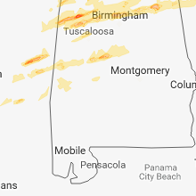
Alabama
| Local Time | Report Details |
|---|---|
| 1:45 PM CDT | Trees down in the kingsville community... northeast of detroi in lamar county AL, 46.8 miles ENE of Starkville, MS |
| 1:45 PM CDT | Three trees down in detroi in lamar county AL, 53.7 miles NE of Starkville, MS |
| 2:30 PM CDT | Trees and branches blown down along highway 18 in marion county AL, 37.4 miles SSW of Florence, AL |
| 2:33 PM CDT | Large branches blown down along highway 17 in marion county AL, 36.7 miles SSW of Florence, AL |
| 2:50 PM CDT | Quarter sized hail reported near Kennedy, AL, 46.8 miles ENE of Starkville, MS |
| 2:59 PM CDT | Trees and power lines down on riverton rose trai in colbert county AL, 21.3 miles W of Florence, AL |
| 3:08 PM CDT | Quarter sized hail reported near Fayette, AL, 57.1 miles ENE of Starkville, MS |
| 3:11 PM CDT | Corrects previous tstm wnd dmg report from 13 ssw moulton. trees down on cr6 in the bankhead forest on the lawrence/winston county lin in lawrence county AL, 38.9 miles SSE of Florence, AL |
| 3:12 PM CDT | Golf Ball sized hail reported near Fayette, AL, 58.9 miles ENE of Starkville, MS |
| 3:17 PM CDT | Trees down on hwy 33 south of the intersection of hwy 3 in lawrence county AL, 33.7 miles SE of Florence, AL |
| 3:17 PM CDT | Trees down on cr6 in the bankhead forest on the lawrence/winston county lin in lawrence county AL, 38.9 miles SSE of Florence, AL |
| 3:52 PM CDT | Trees blown down on hickory lane. quarter same hail was reported at the same locatio in winston county AL, 44.9 miles NNW of Birmingham, AL |
| 3:55 PM CDT | Bleachers were blown down near the fire station. baseball dugout damage in winston county AL, 45.2 miles NNW of Birmingham, AL |
| 4:00 PM CDT | Quarter sized hail reported near Jasper, AL, 34 miles NW of Birmingham, AL |
| 4:04 PM CDT | Corrects previous funnel cloud report from 1 s good hope. wall cloud reported over i-65 between dodge city and good hop in cullman county AL, 39.4 miles N of Birmingham, AL |
| 4:07 PM CDT | An outbuilding was damage in walker county AL, 29.3 miles NW of Birmingham, AL |
| 4:18 PM CDT | Several trees and power lines blown dow in walker county AL, 22.8 miles NNW of Birmingham, AL |
| 4:30 PM CDT | Damage to the white city community center. possible tornad in cullman county AL, 40 miles N of Birmingham, AL |
| 5:13 PM CDT | Structural damage in allgood. possible tornad in blount county AL, 32 miles NNE of Birmingham, AL |
| 5:13 PM CDT | Trees down and outbuildings damaged. possible tornad in blount county AL, 35.1 miles NE of Birmingham, AL |
| 5:16 PM CDT | Damage to roofs and siding of two storage buildings on hwy 278 near the intersection with cr 1682. possible tornad in cullman county AL, 46.5 miles NNE of Birmingham, AL |
| 5:47 PM CDT | Several trees uprooted and snapped off. local roads have been closed due to damage. possible tornad in st. clair county AL, 27.3 miles ENE of Birmingham, AL |
| 5:47 PM CDT | Trees and power lines were blown dow in st. clair county AL, 27.9 miles NE of Birmingham, AL |
| 5:56 PM CDT | Several chicken houses damaged and trees down. possible tornad in st. clair county AL, 30 miles ENE of Birmingham, AL |
| 6:18 PM CDT | Several trees down north of ohatche in st. clair county AL, 48.9 miles ENE of Birmingham, AL |
| 6:23 PM CDT | Several trees blown down along highway 5... possible tornad in perry county AL, 54.9 miles N of Camden, AL |
| 6:49 PM CDT | Numerous trees down near highway 219. possible tornad in perry county AL, 52.5 miles SSW of Birmingham, AL |
| 6:50 PM CDT | Several trees down in eastern chilton county. video indicated several power flashes in the same area. possible tornad in chilton county AL, 43.2 miles SSE of Birmingham, AL |
| 7:07 PM CDT | Tree and roof damage near highway 2 in marengo county AL, 30.1 miles NW of Camden, AL |
| 7:17 PM CDT | Quarter sized hail reported near Jemison, AL, 42.1 miles S of Birmingham, AL |
| 7:41 PM CDT | Numerous trees down and many structures were damaged. possible tornad in chilton county AL, 42.5 miles SSE of Birmingham, AL |
| 9:35 PM CDT | Trees and powerlines down near lightwood road and hogan road. possible tornad in elmore county AL, 49.5 miles W of Auburn, AL |
| 10:08 PM CDT | Side of building damaged along highway 48. limbs and branches in roads south of wedowee and around tin shop and woodlan in randolph county AL, 49.9 miles N of Auburn, AL |
| 10:24 PM CDT | Quarter sized hail reported near Collinsville, AL, 65.3 miles SSW of Chattanooga, TN, quarter sized hail reported in collinsville. location estimated by radar. report relayed via social media. |
Michigan
| Local Time | Report Details |
|---|---|
| 4:05 PM EDT | Quarter sized hail reported near Saint Joseph, MI, 60.7 miles ENE of Chicago, IL |
| 4:10 PM EDT | Half Dollar sized hail reported near Saint Joseph, MI, 59.9 miles ENE of Chicago, IL, lots of smaller pieces of hail with a few to half dollar. |
| 4:12 PM EDT | Half Dollar sized hail reported near Saint Joseph, MI, 61.3 miles ENE of Chicago, IL, time estimated by radar. |
| 4:28 PM EDT | Half Dollar sized hail reported near Hartford, MI, 59.9 miles SSW of Grand Rapids, MI, hail stones ranged from quarter size to half dollar. courtesy of wsbt. |
| 4:33 PM EDT | Multiple trees blown down east of dowagiac along marcellus highwa in cass county MI, 64.9 miles S of Grand Rapids, MI |
| 4:33 PM EDT | Corrects previous tstm wnd dmg report from 1 e marcellus. multiple trees blown down east of dowagiac along marcellus highwa in cass county MI, 69.9 miles SSW of Grand Rapids, MI |
| 4:35 PM EDT | Quarter sized hail reported near Adrian, MI, 76.5 miles NE of Fort Wayne, IN |
| 4:36 PM EDT | Awos station lwa... south haven rgnl arp in van buren county MI, 51.5 miles SW of Grand Rapids, MI |
| 5:20 PM EDT | Tree down on 100th street a few miles east of caledonia. relayed via social media. time estimated by rada in kent county MI, 15.8 miles SE of Grand Rapids, MI |
| 5:30 PM EDT | Ten inch diameter tree blocking s 14th street in schoolcraf in kalamazoo county MI, 57.8 miles S of Grand Rapids, MI |
| 6:02 PM EDT | Quarter sized hail reported near Charlotte, MI, 51.2 miles ESE of Grand Rapids, MI, reported at island highway and interstate 69... charlotte mi. |
| 6:05 PM EDT | Half Dollar sized hail reported near Charlotte, MI, 51.6 miles ESE of Grand Rapids, MI, reported at 813 east shaw st... charlotte mi. hail measured from 1 inch to 1.25 inch. estimate time period was 6pm to 6:05pm. |
| 6:30 PM EDT | Quarter sized hail reported near Haslett, MI, 40.3 miles WSW of Flint, MI |
| 7:23 PM EDT | Three trailers damaged by what is believed to be straight line winds. trailers exhibited roof damage and damage to skirting panels. additionally... one of the trailers in genesee county MI, 9.5 miles NNE of Flint, MI |
| 7:30 PM EDT | Quarter sized hail reported near Manchester, MI, 59.9 miles SSW of Flint, MI |
| 7:35 PM EDT | Ping Pong Ball sized hail reported near Chelsea, MI, 55.6 miles SSW of Flint, MI |
| 7:35 PM EDT | Measured wind gust taken at livingston county airpor in livingston county MI, 30.2 miles SSW of Flint, MI |
| 7:38 PM EDT | Tuscola county central dispatch reported numerous trees down and a porch roof blown off in the mayville are in tuscola county MI, 28.4 miles NE of Flint, MI |
| 7:44 PM EDT | Quarter sized hail reported near Dexter, MI, 46.5 miles S of Flint, MI |
| 8:33 PM EDT | Quarter sized hail reported near Milford, MI, 29.4 miles S of Flint, MI |
| 9:22 PM EDT | Macomb county dispatch reports wires down throughout the city of sterling heights. time estimated from rada in macomb county MI, 44.7 miles SE of Flint, MI |
| 9:30 PM EDT | Macomb county dispatch reports trees down across clinton township. time estimated by rada in macomb county MI, 48.6 miles SE of Flint, MI |
Ohio
| Local Time | Report Details |
|---|---|
| 4:25 PM EDT | Quarter sized hail reported near Fayette, OH, 57.3 miles NE of Fort Wayne, IN |
| 4:26 PM EDT | Quarter sized hail reported near West Unity, OH, 50.7 miles NE of Fort Wayne, IN |
| 5:10 PM EDT | Quarter sized hail reported near Cincinnati, OH, 3.8 miles NNW of Cincinnati, OH |
| 5:13 PM EDT | Storm damage reported in hamilton county OH, 4.6 miles E of Cincinnati, OH |
| 5:19 PM EDT | Significant damage to gas station canopy on montgomery rd near interstate 71. time estimated via rada in hamilton county OH, 9.7 miles NE of Cincinnati, OH |
| 5:24 PM EDT | Large section of fence collapsed. time estimated via rada in clermont county OH, 16.6 miles ENE of Cincinnati, OH |
| 5:44 PM EDT | Large tree uprooted and on hous in hamilton county OH, 6.8 miles W of Cincinnati, OH |
| 5:57 PM EDT | Snapped power pole along route 6 in clinton county OH, 41.8 miles ENE of Cincinnati, OH |
| 6:13 PM EDT | Quarter sized hail reported near Cincinnati, OH, 6.5 miles NE of Cincinnati, OH, occurred in pleasant ridge. twitter report |
| 6:15 PM EDT | Quarter sized hail reported near Cincinnati, OH, 8.8 miles NE of Cincinnati, OH |
| 6:21 PM EDT | Quarter sized hail reported near Milford, OH, 12.6 miles ENE of Cincinnati, OH |
| 6:40 PM EDT | Quarter sized hail reported near Cincinnati, OH, 10.5 miles E of Cincinnati, OH |
| 6:41 PM EDT | Half Dollar sized hail reported near Pleasant Plain, OH, 25.9 miles ENE of Cincinnati, OH, harlan township. via twitter. |
| 6:48 PM EDT | Storm damage reported in clinton county OH, 42.6 miles ENE of Cincinnati, OH |
| 6:48 PM EDT | Quarter sized hail reported near Cincinnati, OH, 10.5 miles E of Cincinnati, OH, near julifs park. |
| 6:52 PM EDT | Trees snapped. power pole downed. time estimated via rada in clinton county OH, 49.1 miles SW of Columbus, OH |
| 6:55 PM EDT | Barn and silo blown down. 4 power poles downe in clinton county OH, 49.7 miles SW of Columbus, OH |
| 6:56 PM EDT | One shed demolished... power poles snapped... and live wires downed. time estimated via radar in clinton county OH, 50.2 miles SW of Columbus, OH |
| 7:18 PM EDT | Downed power pole in madison county OH, 22.1 miles SW of Columbus, OH |
| 7:20 PM EDT | Several trees down across state route 730 between wilmington and blanchester in clinton county OH, 35.3 miles ENE of Cincinnati, OH |
| 7:26 PM EDT | Barn and wires down near us 62. time estimated via rada in brown county OH, 42 miles ESE of Cincinnati, OH |
| 7:35 PM EDT | Quarter sized hail reported near Washington Court House, OH, 36.9 miles SW of Columbus, OH, via social media. |
| 7:39 PM EDT | Quarter sized hail reported near Blanchester, OH, 32.2 miles ENE of Cincinnati, OH, social media report. time estiamted via radar. |
| 7:44 PM EDT | Trees and power lines down at bixby rd and ebright rd. time estimated from rada in franklin county OH, 9.5 miles SE of Columbus, OH |
| 7:54 PM EDT | Quarter size hail and tree down on route 8 in holmes county OH, 69.5 miles ENE of Columbus, OH |
| 7:58 PM EDT | Tree down along county road 24 near hwy 6 in coshocton county OH, 61.8 miles ENE of Columbus, OH |
| 7:58 PM EDT | Tree down near state route 83 in coshocton county OH, 65.7 miles ENE of Columbus, OH |
| 7:59 PM EDT | Tree down along county rd. 1192 in coshocton county OH, 61.2 miles ENE of Columbus, OH |
| 8:06 PM EDT | Tree down along walnut creek bottom r in tuscarawas county OH, 63.2 miles S of Cleveland, OH |
| 8:08 PM EDT | Tree and utility wires dow in stark county OH, 53 miles S of Cleveland, OH |
| 8:13 PM EDT | Storm damage reported in licking county OH, 29.1 miles E of Columbus, OH |
| 8:19 PM EDT | Storm damage reported in stark county OH, 51.2 miles SSE of Cleveland, OH |
| 8:20 PM EDT | Tree and wires dow in stark county OH, 48 miles SSE of Cleveland, OH |
| 8:20 PM EDT | Large tree down on house on 14th stree in stark county OH, 50.9 miles SSE of Cleveland, OH |
| 8:25 PM EDT | Power pole snapped. time estimated from rada in fairfield county OH, 27.2 miles SE of Columbus, OH |
| 8:26 PM EDT | Trees and power lines down along chapel s in stark county OH, 51.7 miles SSE of Cleveland, OH |
| 8:30 PM EDT | Several trees down near pilot knob ave. and hahn s in stark county OH, 47.3 miles SSE of Cleveland, OH |
| 8:36 PM EDT | Three power poles down along route 204 west of thornville in perry county OH, 29.2 miles E of Columbus, OH |
| 8:52 PM EDT | Tree down near state route 172 and sanor r in columbiana county OH, 52.8 miles WNW of Pittsburgh, PA |
| 10:50 PM EDT | Several trees leaning/down across park avenue in perry county OH, 45.6 miles ESE of Columbus, OH |
| 11:15 PM EDT | Quarter sized hail reported near Logan, OH, 48.4 miles SE of Columbus, OH |
| 12:50 AM EDT | 2 trees down on state route 93 in lawrence county OH, 59.1 miles WNW of Charleston, WV |
Georgia
| Local Time | Report Details |
|---|---|
| 8:05 PM EDT | Two trees and a power line were downed on booger hollow roa in floyd county GA, 55.3 miles WNW of Atlanta, GA |
Connect with Interactive Hail Maps