

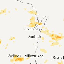
Hail Map for Wednesday, May 11, 2011

Number of Impacted Households on 5/11/2011
0
Impacted by 1" or Larger Hail
0
Impacted by 1.75" or Larger Hail
0
Impacted by 2.5" or Larger Hail
Square Miles of Populated Area Impacted on 5/11/2011
0
Impacted by 1" or Larger Hail
0
Impacted by 1.75" or Larger Hail
0
Impacted by 2.5" or Larger Hail


Cities Most Affected by Hail Storms of 5/11/2011
| Hail Size | Demographics of Zip Codes Affected | ||||||
|---|---|---|---|---|---|---|---|
| City | Count | Average | Largest | Pop Density | House Value | Income | Age |
| Fort Atkinson, WI | 2 | 3.00 | 4.25 | 190 | $121k | $47.8k | 41.1 |
| Mason, TX | 3 | 1.75 | 1.75 | 1 | $56k | $32.0k | 48.6 |
| Mountain Rest, SC | 2 | 2.38 | 2.75 | 19 | $81k | $31.7k | 47.9 |
| Jefferson, WI | 2 | 1.88 | 2.00 | 147 | $117k | $43.7k | 39.2 |
| Independence, VA | 2 | 1.75 | 1.75 | 36 | $82k | $27.8k | 48.0 |
| Long Creek, SC | 1 | 2.75 | 2.75 | 12 | $95k | $22.7k | 42.8 |
| Johnson Creek, WI | 1 | 2.75 | 2.75 | 127 | $129k | $47.1k | 35.4 |
| Walhalla, SC | 1 | 2.75 | 2.75 | 156 | $83k | $32.5k | 38.6 |
| Hartland, WI | 1 | 2.00 | 2.00 | 564 | $204k | $69.1k | 40.7 |
| Nodaway, IA | 1 | 2.00 | 2.00 | 6 | $24k | $33.8k | 45.5 |
| Payson, IL | 1 | 2.00 | 2.00 | 40 | $65k | $39.8k | 39.0 |
| Pittsfield, IL | 1 | 2.00 | 2.00 | 37 | $68k | $31.3k | 43.0 |
| Valparaiso, IN | 1 | 1.75 | 1.75 | 441 | $134k | $50.5k | 35.8 |
| Madison, WI | 1 | 1.75 | 1.75 | 2883 | $129k | $52.0k | 42.6 |
| Burlington, CO | 1 | 1.75 | 1.75 | 6 | $85k | $34.7k | 38.4 |
| Wimberley, TX | 1 | 1.75 | 1.75 | 70 | $141k | $52.8k | 49.9 |
| Hannibal, MO | 1 | 1.75 | 1.75 | 209 | $63k | $31.2k | 38.2 |
| Quemado, TX | 1 | 1.75 | 1.75 | 8 | $39k | $13.8k | 37.4 |
| Salix, IA | 1 | 1.75 | 1.75 | 12 | $95k | $40.0k | 42.4 |
| Tomah, WI | 1 | 1.75 | 1.75 | 103 | $82k | $38.3k | 39.8 |
| Delavan, IL | 1 | 1.75 | 1.75 | 23 | $77k | $45.7k | 42.3 |
| Doss, TX | 1 | 1.75 | 1.75 | 1 | $83k | $35.6k | 56.4 |
| Llano, TX | 1 | 1.75 | 1.75 | 10 | $85k | $35.8k | 51.0 |
Hail and Wind Damage Spotted on 5/11/2011
Filter by Report Type:Hail ReportsWind Reports
States Impacted
Wisconsin, Kansas, Texas, Missouri, Michigan, Nebraska, Oklahoma, Illinois, Iowa, South Carolina, North Carolina, Florida, Colorado, South Dakota, Virginia, Georgia, Arkansas, Indiana, OhioWisconsin
| Local Time | Report Details |
|---|---|
| 12:00 PM UTC | Quarter sized hail reported near Pound, WI, 39.9 miles N of Green Bay, WI |
| 2:37 PM UTC | Half Dollar sized hail reported near Oconto Falls, WI, 27 miles NNW of Green Bay, WI, delayed report |
| 2:38 PM UTC | Quarter sized hail reported near Oconto Falls, WI, 27 miles NNW of Green Bay, WI |
| 4:30 PM UTC | Quarter sized hail reported near Menomonie, WI, 65.9 miles E of Minneapolis, MN |
| 4:47 PM UTC | Quarter sized hail reported near Oconto Falls, WI, 27 miles NNW of Green Bay, WI, minor branch damage |
| 6:36 PM UTC | Quarter sized hail reported near Madison, WI, 1.4 miles ENE of Madison, WI |
| 6:41 PM UTC | Quarter sized hail reported near Madison, WI, 5.4 miles NNE of Madison, WI |
| 6:43 PM UTC | Quarter sized hail reported near McFarland, WI, 6.1 miles SE of Madison, WI |
| 6:43 PM UTC | Quarter sized hail reported near Madison, WI, 6.7 miles NE of Madison, WI |
| 6:45 PM UTC | Half Dollar sized hail reported near Madison, WI, 3.4 miles E of Madison, WI |
| 6:47 PM UTC | Half Dollar sized hail reported near Madison, WI, 6 miles NE of Madison, WI |
| 6:47 PM UTC | Ping Pong Ball sized hail reported near Madison, WI, 6.7 miles NE of Madison, WI |
| 7:00 PM UTC | Hen Egg sized hail reported near , , 9.8 miles ESE of Madison, WI, delayed report. video and images of ice cube sized hail in traffic on i-90. |
| 7:01 PM UTC | Golf Ball sized hail reported near Tomah, WI, 41.2 miles ENE of La Crosse, WI, hail damage to police cars on highway 16 se of tomah. |
| 7:26 PM UTC | Golf Ball sized hail reported near Fort Atkinson, WI, 24.6 miles ESE of Madison, WI, reported by sheriff deputy at intersection of highway 12 and highway j. |
| 7:28 PM UTC | Quarter sized hail reported near Sun Prairie, WI, 10.1 miles NE of Madison, WI |
| 7:30 PM UTC | Quarter sized hail reported near Waterloo, WI, 20.7 miles E of Madison, WI |
| 2:34 PM CDT | Grapefruit sized hail reported near Fort Atkinson, WI, 25.5 miles E of Madison, WI, softball size hail reported at intersection of highways 18 and 89. |
| 2:40 PM CDT | Hen Egg sized hail reported near Jefferson, WI, 29.4 miles E of Madison, WI |
| 7:40 PM UTC | Baseball sized hail reported near Johnson Creek, WI, 31.2 miles E of Madison, WI, delayed report of baseball sized hail and broken windows. |
| 2:43 PM CDT | Golf Ball sized hail reported near Jefferson, WI, 29.5 miles E of Madison, WI |
| 7:56 PM UTC | Quarter sized hail reported near Sparta, WI, 28.5 miles ENE of La Crosse, WI |
| 9:08 PM UTC | Half Dollar sized hail reported near Verona, WI, 9.6 miles SW of Madison, WI |
| 9:28 PM UTC | Half Dollar sized hail reported near Madison, WI, 1.6 miles SSE of Madison, WI |
| 4:30 PM CDT | Hen Egg sized hail reported near Hartland, WI, 53 miles E of Madison, WI, delayed report. |
| 9:37 PM UTC | Quarter sized hail reported near Monona, WI, 3.7 miles SE of Madison, WI |
| 4:40 PM CDT | Quarter sized hail reported near Delafield, WI, 53 miles E of Madison, WI |
| 4:44 PM CDT | Half Dollar sized hail reported near Hartland, WI, 53 miles E of Madison, WI |
| 9:45 PM UTC | Golf Ball sized hail reported near Monona, WI, 3.3 miles ESE of Madison, WI, at intersection of broadway and highway 51. |
| 9:50 PM UTC | Quarter sized hail reported near Cottage Grove, WI, 8 miles E of Madison, WI |
Kansas
| Local Time | Report Details |
|---|---|
| 2:16 PM UTC | Quarter sized hail reported near Spearville, KS, 58.3 miles ESE of Garden City, KS |
| 2:17 PM UTC | Half Dollar sized hail reported near Wright, KS, 57.9 miles E of Garden City, KS |
| 3:30 PM UTC | Quarter sized hail reported near Bluff City, KS, 54.7 miles SW of Wichita, KS |
| 4:54 PM UTC | Quarter sized hail reported near Lincoln, KS, 62.3 miles E of Hays, KS |
| 5:15 PM UTC | Storm damage reported in mitchell county KS, 74.8 miles ENE of Hays, KS |
| 5:23 PM UTC | Quarter sized hail reported near Randall, KS, 85.8 miles WNW of Manhattan, KS, nickel to quarter size hail |
| 6:06 PM UTC | Quarter sized hail reported near Jewell, KS, 86.5 miles WNW of Manhattan, KS, also heavy rain with visibility of 150 ft. 35-40 mph wind gusts. |
| 6:11 PM UTC | Quarter sized hail reported near Bremen, KS, 51 miles NNW of Manhattan, KS |
| 8:40 PM UTC | 4.5 miles west of cedar vale on highway 16 in cowley county KS, 52.8 miles SE of Wichita, KS |
| 9:52 PM UTC | Storm damage reported in greenwood county KS, 46.9 miles WNW of Chanute, KS |
| 10:31 PM UTC | Fallen tree blocking the road just south of the greenhous in greenwood county KS, 46.9 miles WNW of Chanute, KS |
| 11:32 PM UTC | Storm damage reported in labette county KS, 37 miles S of Chanute, KS |
| 11:45 PM UTC | Quarter sized hail reported near Fairview, KS, 61.5 miles NE of Manhattan, KS, nickel to quarter size hail. |
| 11:55 PM UTC | Quarter sized hail reported near Atwood, KS, 14 miles N of Colby, KS |
| 12:05 AM UTC | Quarter sized hail reported near Sabetha, KS, 66.4 miles NE of Manhattan, KS |
| 12:20 AM UTC | Emergency management reports large tree dow in cherokee county KS, 51.5 miles SE of Chanute, KS |
| 12:25 AM UTC | Quarter sized hail reported near Pittsburg, KS, 45.3 miles ESE of Chanute, KS |
| 12:35 AM UTC | Emergency management reports large tree dow in cherokee county KS, 59.1 miles SE of Chanute, KS |
| 1:30 AM UTC | Quarter sized hail reported near Oberlin, KS, 40.1 miles NE of Colby, KS, also reporting some street flooding in town. |
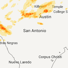
Texas
| Local Time | Report Details |
|---|---|
| 3:05 PM UTC | Quarter sized hail reported near Ballinger, TX, 50.5 miles SSW of Abilene, TX, quarter size hail at krun studios in south ballinger. |
| 3:15 PM UTC | Ping Pong Ball sized hail reported near Rowena, TX, 56.5 miles SSW of Abilene, TX, hail just under the size of golf balls and winds of 50-60 mph 4 miles north of the concho and runnels county line on u.s. highway 83. |
| 4:15 PM UTC | Quarter sized hail reported near Coleman, TX, 45.8 miles SSE of Abilene, TX, report from ktxs employee |
| 5:04 PM UTC | Quarter sized hail reported near Mountain Home, TX, 89.4 miles NW of San Antonio, TX |
| 5:20 PM UTC | Wind gusts estimated between 60 and 70 mph on the southwest side of possum kingdom lake in palo pinto county TX, 70.2 miles S of Wichita Falls, TX |
| 5:20 PM UTC | Quarter sized hail reported near Graford, TX, 70.2 miles S of Wichita Falls, TX, quarter size hail reported on the southwest side of possum kingdom lake |
| 6:00 PM UTC | Report of cars blown off the road 10 mi n of stephenville on hwy 108 in erath county TX, 86.6 miles WSW of Dallas, TX |
| 6:18 PM UTC | Quarter sized hail reported near Zephyr, TX, 73.8 miles WNW of Killeen, TX, hail was at least the size of quarters |
| 6:19 PM UTC | Bethel road and horseshoe bend road in parker county TX, 62.8 miles W of Dallas, TX |
| 6:33 PM UTC | Storm damage reported in parker county TX, 53.3 miles WNW of Dallas, TX |
| 6:35 PM UTC | Mobile home blown off foundation; out buildings blown into trees; intersection of cr 1655 and fm 1810 in wise county TX, 56.3 miles SE of Wichita Falls, TX |
| 6:35 PM UTC | Few tree limbs down and damage to the roof of a bar in san saba county TX, 64.4 miles W of Killeen, TX |
| 6:42 PM UTC | Power lines down at fm 2123 and sh 114 in bridgeport in wise county TX, 63.5 miles SE of Wichita Falls, TX |
| 6:45 PM UTC | Restaurant sign damage along 287 in decatur; time estimated by radar in wise county TX, 56.1 miles NW of Dallas, TX |
| 6:54 PM UTC | Tractor trailers blown off road at the intersection of hwy 287 and fm 407; estimated 65 mph wind in wise county TX, 44.2 miles WNW of Dallas, TX |
| 6:55 PM UTC | A 30'x15' post barn was destroyed with the debris scattered approximately 1/4 mile to the northeast. the posts of the barn were ripped out of the groun in montague county TX, 56.2 miles ESE of Wichita Falls, TX |
| 6:55 PM UTC | Roof off home and power poles snapped on fm 2264 approx. 3 to 4 mi west of denton county lin in wise county TX, 44.6 miles WNW of Dallas, TX |
| 6:55 PM UTC | Quarter sized hail reported near Mullin, TX, 63.2 miles WNW of Killeen, TX, some quarter size hail was reported in the mullin area |
| 6:58 PM UTC | Metal light poles bent in in tarrant county TX, 38.1 miles W of Dallas, TX |
| 7:04 PM UTC | Measured 50 kts at nws office in fort worth in tarrant county TX, 31.8 miles W of Dallas, TX |
| 7:10 PM UTC | Quarter sized hail reported near Keller, TX, 28.7 miles WNW of Dallas, TX, intersection of roanoke and knox in north keller |
| 7:15 PM UTC | Tree in comanche county TX, 64.3 miles NW of Killeen, TX |
| 7:15 PM UTC | Golf Ball sized hail reported near Doss, TX, 84.1 miles NNW of San Antonio, TX, photos relayed through media |
| 7:33 PM UTC | 65 mph wind gust measured in irving in dallas county TX, 7.8 miles WNW of Dallas, TX |
| 7:35 PM UTC | 5 miles w of sherman in grayson county TX, 59.2 miles N of Dallas, TX |
| 7:37 PM UTC | Damage to barns and outbuildings 1 se of gainesville in cooke county TX, 61.4 miles NNW of Dallas, TX |
| 7:40 PM UTC | Partial roof off a residence. suburban vehicle was flipped on its side and 8 outbuildings destroyed. reports were on the 500 block of crow roa in grayson county TX, 60.5 miles N of Dallas, TX |
| 7:41 PM UTC | Storm damage reported in grayson county TX, 55 miles N of Dallas, TX |
| 7:45 PM UTC | Trailer home damaged and automobile overturned in grayson county TX, 60.7 miles N of Dallas, TX |
| 7:50 PM UTC | Quarter sized hail reported near Llano, TX, 77.9 miles WSW of Killeen, TX, pea to 1 hail and heavy rain |
| 7:55 PM UTC | 62 mph gust measured at sherman/denison airport in grayson county TX, 52.7 miles SSW of Atoka, OK |
| 8:12 PM UTC | Golf Ball sized hail reported near Quemado, TX, 32.9 miles SSE of Del Rio, TX |
| 8:39 PM UTC | Quarter sized hail reported near Llano, TX, 61.4 miles WSW of Killeen, TX |
| 4:17 PM CDT | Golf Ball sized hail reported near Mason, TX, 92.8 miles WSW of Killeen, TX, golf ball size hail reported in mason. |
| 9:31 PM UTC | Golf Ball sized hail reported near Mason, TX, 94.5 miles WSW of Killeen, TX, golf ball size hail reported 3 miles nw of mason. |
| 9:35 PM UTC | Large tree branches blown down... roof blown off a boat deck in llano county TX, 53.2 miles SW of Killeen, TX |
| 9:58 PM UTC | Quarter sized hail reported near Mason, TX, 94.5 miles WSW of Killeen, TX, quarter size hail reported 3 miles nw of mason |
| 5:20 PM CDT | Quarter sized hail reported near Killeen, TX, 2 miles SE of Killeen, TX, w side of fort hood |
| 10:20 PM UTC | W side of fort hood in bell county TX, 2 miles SE of Killeen, TX |
| 10:30 PM UTC | Quarter sized hail reported near Bertram, TX, 36.6 miles SSW of Killeen, TX, large hail near oatmeal along with an inch of rainfall in less than 30 miniutes. |
| 10:55 PM UTC | Storm damage reported in bell county TX, 16.3 miles ENE of Killeen, TX |
| 11:02 PM UTC | In t in bell county TX, 22.4 miles E of Killeen, TX |
| 11:45 PM UTC | Ping Pong Ball sized hail reported near Llano, TX, 75.6 miles WSW of Killeen, TX, ping pong ball size hail and 1.90 inches of rainfall in 30 minutes. |
| 11:55 PM UTC | Golf Ball sized hail reported near Mason, TX, 91.6 miles NNW of San Antonio, TX, golf ball size hail reported 11 miles south of mason. sheiffs office reports a vehicle lost control due to the hail but no injuries were reported. |
| 12:20 AM UTC | Quarter sized hail reported near Doss, TX, 77.9 miles NNW of San Antonio, TX, nickel to near quarter size hail. |
| 12:20 AM UTC | Golf Ball sized hail reported near Llano, TX, 68.4 miles WSW of Killeen, TX, half inch to golfball size hail and heavy rain. |
| 1:08 AM UTC | Quarter sized hail reported near Moody, TX, 26.4 miles ENE of Killeen, TX, quarter sized hail in moody |
| 1:15 AM UTC | Half Dollar sized hail reported near Moody, TX, 26.4 miles ENE of Killeen, TX |
| 1:23 AM UTC | Quarter sized hail reported near Bruceville, TX, 35.1 miles ENE of Killeen, TX |
| 8:40 PM CDT | Quarter sized hail reported near Killeen, TX, 0.9 miles N of Killeen, TX, reported 1.6nm ene of kgrk |
| 9:00 PM CDT | 18-24 inch in diameter tree blown down on 18th street in killeen in bell county TX, 0.9 miles N of Killeen, TX |
| 9:10 PM CDT | Storm damage reported in bell county TX, 0.9 miles N of Killeen, TX |
| 2:41 AM UTC | Quarter sized hail reported near Florence, TX, 20 miles SSW of Killeen, TX, quarter size hail |
| 3:09 AM UTC | Quarter sized hail reported near Jarrell, TX, 21.1 miles SSE of Killeen, TX, half inch to inch size hail in jarrell |
| 3:15 AM UTC | Quarter sized hail reported near Jarrell, TX, 23.1 miles SSE of Killeen, TX, one inch hail and wind gusts to 40 mph. |
| 3:15 AM UTC | Quarter sized hail reported near Jarrell, TX, 19.9 miles SSE of Killeen, TX, half inch to one inch size hail and strong winds. 1.20 inches of rainfall. |
| 3:15 AM UTC | 10 inch diameter trees downed in bell county TX, 26.1 miles ENE of Killeen, TX |
| 3:42 AM UTC | Storm damage reported in bell county TX, 27.5 miles SE of Killeen, TX |
| 3:42 AM UTC | Quarter sized hail reported near Bartlett, TX, 27.5 miles SE of Killeen, TX |
| 3:56 AM UTC | Golf Ball sized hail reported near Wimberley, TX, 51.6 miles NNE of San Antonio, TX, golf ball size hail along with heavy rain. |
| 9:30 AM UTC | Quarter sized hail reported near Del Rio, TX, 36.5 miles N of Del Rio, TX, devils river st pk |
| 10:25 AM UTC | Quarter sized hail reported near Del Rio, TX, 24.8 miles N of Del Rio, TX |
| 10:50 AM UTC | Quarter sized hail reported near Rocksprings, TX, 32.6 miles NNE of Del Rio, TX |
| 11:45 AM UTC | Quarter sized hail reported near Brackettville, TX, 32.6 miles ENE of Del Rio, TX |
Missouri
| Local Time | Report Details |
|---|---|
| 4:23 PM UTC | Storm damage reported in macon county MO, 56.6 miles N of Columbia, MO |
| 4:55 PM UTC | Trees were reported uprooted with wind gusts estimated to 60 mp in adair county MO, 43 miles WSW of Kahoka, MO |
| 5:00 PM UTC | Measured at a university of missouri ag weather site in knox county MO, 37 miles SW of Kahoka, MO |
| 5:10 PM UTC | Large tree branch down blocking part of highway f...around 2 miles west of highway 15 in knox county MO, 33.5 miles SW of Kahoka, MO |
| 7:11 PM UTC | Half Dollar sized hail reported near New London, MO, 62.3 miles SSE of Kahoka, MO, lasted 5 minutes |
| 7:16 PM UTC | Quarter sized hail reported near New London, MO, 63.8 miles SSE of Kahoka, MO, along highway 79 |
| 7:37 PM UTC | Quarter sized hail reported near Hannibal, MO, 52.2 miles SSE of Kahoka, MO, still hailing. |
| 7:44 PM UTC | Golf Ball sized hail reported near Hannibal, MO, 52.2 miles SSE of Kahoka, MO |
| 7:45 PM UTC | 3 powerpoles reported blown down in atchison county MO, 56.4 miles SSE of Omaha, NE |
| 9:11 PM UTC | Quarter sized hail reported near King City, MO, 65.4 miles N of Kansas City, MO, emergency management reported quarter size hailin town |
| 12:23 AM UTC | Several trees and limbs down in the vicinity of cedar street and mud springs road. one barn damaged as wel in mcdonald county MO, 72.9 miles WSW of Springfield, MO |
| 1:25 AM UTC | Barn roof blown off at papponsville and machinery inside moved several feet in bates county MO, 70.7 miles ENE of Chanute, KS |
| 1:35 AM UTC | Tree down on power line and a few limbs down across 5th street in st. clair county MO, 68.6 miles SSE of Kansas City, MO |
| 2:03 AM UTC | Tree uprooted downed power line in bates county MO, 71.8 miles SSE of Kansas City, MO |
| 2:30 AM UTC | 100 block main street in warren in johnson county MO, 51.7 miles ESE of Kansas City, MO |
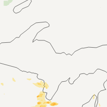
Michigan
| Local Time | Report Details |
|---|---|
| 5:29 PM UTC | Half Dollar sized hail reported near Norman, MI, 40.1 miles SSW of Traverse City, MI |
| 8:25 PM UTC | Ping Pong Ball sized hail reported near Manistee, MI, 51.2 miles SW of Traverse City, MI, ping pong sized hail reported. |
| 9:15 PM UTC | Quarter sized hail reported near Holmes, MI, 70.1 miles SSW of Marquette, MI, estimated time between 515 and 520 edt. |
| 12:27 AM UTC | 7-8 large pine trees...estimated 40 to 50 feet tall...uprooted and laying towards the north...time estimated from radar in berrien county MI, 53.5 miles E of Chicago, IL |
| 1:55 AM UTC | This is the peak wind gust at spyglass hill on the lakeshor in ottawa county MI, 30.2 miles WSW of Grand Rapids, MI |
| 2:30 AM UTC | Quarter sized hail reported near Blendon, MI, 17.9 miles W of Grand Rapids, MI |
Nebraska
| Local Time | Report Details |
|---|---|
| 6:21 PM UTC | Quarter sized hail reported near Adams, NE, 62.8 miles SSW of Omaha, NE, pea to quarter size hail. |
| 6:32 PM UTC | Branches breaking on trees. also 1 inch hai in gage county NE, 65.2 miles N of Manhattan, KS |
| 6:55 PM UTC | Storm damage reported in gage county NE, 73.8 miles SSW of Omaha, NE |
| 7:00 PM UTC | Approximately 20 cars have damaged windows apparently from thunderstorm winds picking up gravel from the parking lot. wind speed likely near 60 mph in clay county NE, 36.7 miles SSE of Grand Island, NE |
| 7:02 PM UTC | Storm damage reported in clay county NE, 37 miles SSE of Grand Island, NE |
| 7:04 PM UTC | Storm damage reported in saline county NE, 75.9 miles SW of Omaha, NE |
| 7:14 PM UTC | Quarter sized hail reported near Adams, NE, 62.8 miles SSW of Omaha, NE, pea to quarter size hail. |
| 7:14 PM UTC | A few tree limbs down...estimated 2-3 inch diamete in gage county NE, 62.8 miles SSW of Omaha, NE |
| 7:14 PM UTC | Estimated 55 to 60 mph winds. also pea to dime size hai in johnson county NE, 59.9 miles SSW of Omaha, NE |
| 7:32 PM UTC | Storm damage reported in york county NE, 40.8 miles ESE of Grand Island, NE |
| 8:00 PM UTC | 60 mph estimated wind gusts blew car off the road in howard county NE, 28.7 miles NNW of Grand Island, NE |
| 8:03 PM UTC | Storm damage reported in polk county NE, 44.9 miles ENE of Grand Island, NE |
| 8:11 PM UTC | 1 inch hail accompanied gust in sarpy county NE, 15.9 miles SW of Omaha, NE |
| 8:15 PM UTC | Storm damage reported in polk county NE, 40.5 miles ENE of Grand Island, NE |
| 8:20 PM UTC | Whole tree blown down on 10 in butler county NE, 61.9 miles W of Omaha, NE |
| 8:32 PM UTC | 70 mph winds estimated at the airport in nance county NE, 48.2 miles NE of Grand Island, NE |
| 8:33 PM UTC | Mainly tree damage in platte county NE, 53.9 miles NE of Grand Island, NE |
| 8:35 PM UTC | Power lines and trees down in polk county NE, 44.9 miles ENE of Grand Island, NE |
| 8:40 PM UTC | Storm damage reported in platte county NE, 63.6 miles ENE of Grand Island, NE |
| 8:42 PM UTC | Pole building destroyed...other outbuildings and grain bins damage in platte county NE, 63.2 miles NE of Grand Island, NE |
| 8:44 PM UTC | 1 inch hail accompanied the gust in dodge county NE, 41.6 miles WNW of Omaha, NE |
| 8:45 PM UTC | Out buildings damaged or destroyed. numerous center pivots overturned in the are in platte county NE, 61.7 miles NE of Grand Island, NE |
| 8:47 PM UTC | Reported by emergency manager. barn roof partly blown of in platte county NE, 64.4 miles NE of Grand Island, NE |
| 8:48 PM UTC | Storm damage reported in boone county NE, 48.3 miles N of Grand Island, NE |
| 9:03 PM UTC | Grain bins blown i in platte county NE, 68.9 miles NE of Grand Island, NE |
| 9:10 PM UTC | Storm damage reported in dodge county NE, 46.4 miles NW of Omaha, NE |
| 9:22 PM UTC | Wind gust picked up and moved mini va in stanton county NE, 74.5 miles ESE of Oneill, NE |
| 9:55 PM UTC | Corrected time of even in thurston county NE, 80.1 miles NNW of Omaha, NE |
| 9:55 PM UTC | Semi blown over in dakota county NE, 81 miles WSW of Storm Lake, IA |
| 9:55 PM UTC | Semi blown over in thurston county NE, 80.2 miles NNW of Omaha, NE |
| 10:09 PM UTC | Storm damage reported in thurston county NE, 80.1 miles NNW of Omaha, NE |
| 10:15 PM UTC | Light pole knocked over in dakota county NE, 62.9 miles W of Storm Lake, IA |
Oklahoma
| Local Time | Report Details |
|---|---|
| 6:30 PM UTC | Storm damage reported in jefferson county OK, 32.2 miles E of Wichita Falls, TX |
| 7:20 PM UTC | Storm damage reported in stephens county OK, 62.1 miles NE of Wichita Falls, TX |
| 7:40 PM UTC | Storm damage reported in carter county OK, 54.9 miles WSW of Atoka, OK |
| 7:52 PM UTC | Roof taken off a large metal building with overhead doors on the east and west sides. no injuries reporte in murray county OK, 56.1 miles W of Atoka, OK |
| 7:52 PM UTC | Roof taken off a large metal shop building with overhead doors on the east and west sides. the building was located near us highway 7 and state highway 110. no injuries in murray county OK, 56.1 miles W of Atoka, OK |
| 8:00 PM UTC | Storm damage reported in murray county OK, 48.5 miles WNW of Atoka, OK |
| 8:10 PM UTC | Also tree limbs down. time estimated from rada in bryan county OK, 44.8 miles SW of Atoka, OK |
| 8:10 PM UTC | Storm damage reported in kay county OK, 60.4 miles SSE of Wichita, KS |
| 8:10 PM UTC | Storm damage reported in kay county OK, 60.4 miles SSE of Wichita, KS |
| 8:15 PM UTC | Storm damage reported in kay county OK, 60.4 miles SSE of Wichita, KS |
| 8:25 PM UTC | Storm damage reported in oklahoma county OK, 5.6 miles NNE of Oklahoma City, OK |
| 8:25 PM UTC | Storm damage reported in osage county OK, 61.1 miles SSE of Wichita, KS |
| 8:40 PM UTC | Storm damage reported in oklahoma county OK, 12.5 miles N of Oklahoma City, OK |
| 8:53 PM UTC | Power poles downed west side of town by thunderstorm winds. report from city hall. time estimated from rada in choctaw county OK, 28.1 miles SSE of Atoka, OK |
| 8:59 PM UTC | Storm damage reported in coal county OK, 11.2 miles NNW of Atoka, OK |
| 9:20 PM UTC | Shingles were blown off of rooftops. carports were damaged. several trees were blown down...along with numerous tree branches. four power poles were blown down. the wor in payne county OK, 45 miles WSW of Tulsa, OK |
| 9:20 PM UTC | Plastic guttering was blown off of a house. large tree branches were also blown down. the winds were estimated at 60 mp in lincoln county OK, 40.3 miles NE of Oklahoma City, OK |
| 9:30 PM UTC | Storm damage reported in payne county OK, 53.9 miles W of Tulsa, OK |
| 9:30 PM UTC | Trees and power lines down...estimated 70 mph winds in washington county OK, 31.1 miles N of Tulsa, OK |
| 9:30 PM UTC | Trees down...powerlines down....estimated 70 mph winds in washington county OK, 31.1 miles N of Tulsa, OK |
| 9:31 PM UTC | Several trees blown down around moyers...many more damaged by wind. metal roofing blown off a she in pushmataha county OK, 27.6 miles E of Atoka, OK |
| 9:40 PM UTC | Trees blown down between snow and finley. power went out in snow about 430...before storms arrive in pushmataha county OK, 39.9 miles E of Atoka, OK |
| 9:43 PM UTC | Storm damage reported in payne county OK, 39.6 miles W of Tulsa, OK |
| 9:43 PM UTC | Considerable tree damage from wind. large limbs broke in pawnee county OK, 46.4 miles WNW of Tulsa, OK |
| 9:47 PM UTC | Trees downed by thunderstorm winds in henryetta. report from volunteer fire departmen in okmulgee county OK, 48.9 miles S of Tulsa, OK |
| 10:00 PM UTC | Large limbs down in creek county OK, 20 miles W of Tulsa, OK |
| 10:00 PM UTC | Five trees blown over...many others damaged. carport picked up and carried 50 yards. mobile home had all skirting damaged/remove in pawnee county OK, 27.6 miles WNW of Tulsa, OK |
| 10:03 PM UTC | Three trees uprooted by the wind. others damage in pushmataha county OK, 46.6 miles ENE of Atoka, OK |
| 10:14 PM UTC | Trees down and damage to the porch of a house in yanush. time estimated based on rada in latimer county OK, 51.7 miles ENE of Atoka, OK |
| 10:20 PM UTC | Large tree blown onto a trailer home near the osage casino. time estimated via rada in osage county OK, 4.2 miles N of Tulsa, OK |
| 10:27 PM UTC | Storm damage reported in osage county OK, 18.2 miles N of Tulsa, OK |
| 10:30 PM UTC | Wind caused damage to the roof on the elementary school cafeteria. time estimated via rada in tulsa county OK, 15.2 miles N of Tulsa, OK |
| 10:30 PM UTC | Tree down across road in beavers bend state par in mccurtain county OK, 50.2 miles WNW of Nashville, AR |
| 10:40 PM UTC | Estimated near 61st and garnett in tulsa county OK, 7.2 miles ESE of Tulsa, OK |
| 10:45 PM UTC | Numerous reports of large trees downed in the city. time estimated via rada in washington county OK, 41.4 miles N of Tulsa, OK |
| 10:52 PM UTC | Several trees were snapped and large limbs were blown down in rogers county OK, 25 miles ENE of Tulsa, OK |
| 10:52 PM UTC | Storm damage reported in rogers county OK, 25 miles ENE of Tulsa, OK |
| 11:01 PM UTC | Storm damage reported in mayes county OK, 36.6 miles E of Tulsa, OK |
| 11:03 PM UTC | Power lines down on redbud road east of chouteau. relayed by emergency managemen in mayes county OK, 37.7 miles E of Tulsa, OK |
| 11:05 PM UTC | Roof blown off barn...trees down in nowata county OK, 52.1 miles NNE of Tulsa, OK |
| 11:07 PM UTC | Several trees were uprooted...large tree limbs were snapped...and the roofs of several homes were damaged in rogers county OK, 33.9 miles ENE of Tulsa, OK |
| 11:07 PM UTC | Large tree limbs were snapped in mayes county OK, 34.4 miles ENE of Tulsa, OK |
| 11:10 PM UTC | Large limbs down along hwy 82 south of locust grove. relayed by emergency managemen in mayes county OK, 46 miles E of Tulsa, OK |
| 11:10 PM UTC | Several barns were damaged by strong thunderstorm wind in rogers county OK, 27.6 miles ENE of Tulsa, OK |
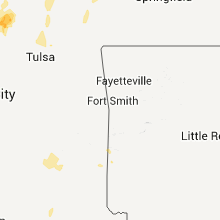
| 11:14 PM UTC | Storm damage reported in sequoyah county OK, 22.5 miles WNW of Fort Smith, AR |
| 11:15 PM UTC | Thunderstorm wind gust measured at the claremore regional airpor in rogers county OK, 23.6 miles ENE of Tulsa, OK |
| 11:23 PM UTC | Large limbs down along hwy 82 south of locust grove. relayed by emergency managemen in mayes county OK, 46 miles E of Tulsa, OK |
| 11:46 PM UTC | 2 to 4 inch limbs down in adair county OK, 38.6 miles NNW of Fort Smith, AR |
| 11:50 PM UTC | Windows blown out in bernice. boats out of water at duck creek marin in delaware county OK, 68.1 miles ENE of Tulsa, OK |
| 11:50 PM UTC | Large tree limbs were blown down. estimated 60 to 65 mph gusts persisted for about 8 minute in adair county OK, 42.6 miles N of Fort Smith, AR |
| 12:15 AM UTC | Storm damage reported in ottawa county OK, 72.4 miles SE of Chanute, KS |
| 12:15 AM UTC | Several large trees blown over. power lines damaged resulting in power outage in ottawa county OK, 64.3 miles SSE of Chanute, KS |
| 12:30 AM UTC | Trees were blown down on highway 60 in ottawa county OK, 72.4 miles SE of Chanute, KS |
Illinois
| Local Time | Report Details |
|---|---|
| 6:58 PM UTC | Quarter sized hail reported near Payson, IL, 49.9 miles SSE of Kahoka, MO, hail ranged in size from pea to quarter. located along highway 72 near the adams and pike county line. |
| 7:12 PM UTC | Hen Egg sized hail reported near Payson, IL, 48.6 miles SSE of Kahoka, MO |
| 7:47 PM UTC | Half Dollar sized hail reported near Barry, IL, 61.4 miles SE of Kahoka, MO |
| 7:52 PM UTC | Quarter sized hail reported near Golden Eagle, IL, 27.4 miles NW of Saint Louis, MO, still hailing. |
| 8:00 PM UTC | Storm damage reported in mcdonough county IL, 56.8 miles E of Kahoka, MO |
| 8:06 PM UTC | Quarter sized hail reported near Pleasant Hill, IL, 69.9 miles NNW of Saint Louis, MO |
| 8:14 PM UTC | Hen Egg sized hail reported near Pittsfield, IL, 73.9 miles SE of Kahoka, MO, reported by illinois state police just south of pittsfield |
| 8:30 PM UTC | Roof blown off an outbuilding near route 99 and county road 1300 e...three poles clipped off and power lines also down....time approximat in brown county IL, 65.3 miles ESE of Kahoka, MO |
| 8:39 PM UTC | 55 to 60 mph winds and heavy rain at okeson road 1/2 miles west of greenwood roa in mchenry county IL, 54.8 miles NW of Chicago, IL |
| 8:52 PM UTC | Large tree limbs blown down and some siding blown off of a few house in knox county IL, 45.2 miles WNW of Peoria, IL |
| 8:55 PM UTC | Quarter sized hail reported near Spring Grove, IL, 49.5 miles NW of Chicago, IL |
| 9:10 PM UTC | Quarter sized hail reported near Spring Grove, IL, 51.6 miles NW of Chicago, IL, route 173 and wilmot road. |
| 4:17 PM CDT | Quarter sized hail reported near Elgin, IL, 35.5 miles WNW of Chicago, IL, plank road and route 20. |
| 9:20 PM UTC | Ping Pong Ball sized hail reported near Crystal Lake, IL, 43.1 miles NW of Chicago, IL, main street and route 14. damage to cars. |
| 9:24 PM UTC | Trees down on route 97 blocking traffic. time estimate in knox county IL, 30.3 miles W of Peoria, IL |
| 9:24 PM UTC | Quarter sized hail reported near Lake in the Hills, IL, 41.2 miles WNW of Chicago, IL |
| 9:26 PM UTC | Quarter sized hail reported near McHenry, IL, 46.2 miles NW of Chicago, IL, route 120 and route 31. |
| 9:37 PM UTC | Storm damage reported in knox county IL, 27 miles WNW of Peoria, IL |
| 9:49 PM UTC | Ping Pong Ball sized hail reported near Crystal Lake, IL, 43.1 miles NW of Chicago, IL |
| 10:04 PM UTC | Quarter sized hail reported near Davis, IL, 43 miles S of Madison, WI |
| 10:04 PM UTC | Quarter sized hail reported near McHenry, IL, 46.2 miles NW of Chicago, IL, route 120 and route 31. |
| 10:25 PM UTC | Golf Ball sized hail reported near Delavan, IL, 22.9 miles SSE of Peoria, IL |
| 10:42 PM UTC | Quarter sized hail reported near Oglesby, IL, 49.6 miles NNE of Peoria, IL, nickel to quarter size hail at i-39 and route 251. |
| 11:15 PM UTC | 8 power poles blown down at ashton road and i-8 in grundy county IL, 55.2 miles SW of Chicago, IL |
| 11:40 PM UTC | Tree blocking road at route 47 and gardner roa in grundy county IL, 63.5 miles SW of Chicago, IL |
| 11:54 PM UTC | Storm damage reported in kendall county IL, 38.2 miles WSW of Chicago, IL |
| 12:05 AM UTC | Quarter sized hail reported near Crest Hill, IL, 32.9 miles SW of Chicago, IL |
| 12:40 AM UTC | Storm damage reported in cook county IL, 11.8 miles SSW of Chicago, IL |
| 7:48 PM CDT | Quarter sized hail reported near Evergreen Park, IL, 11.9 miles SSW of Chicago, IL |
| 1:00 AM UTC | Quarter sized hail reported near Chicago, IL, 11.3 miles S of Chicago, IL, 95th and dan ryan expressway. |
| 1:00 AM UTC | Trees down at 65th and oakle in cook county IL, 7.2 miles SW of Chicago, IL |
Iowa
| Local Time | Report Details |
|---|---|
| 7:36 PM UTC | Half Dollar sized hail reported near Nodaway, IA, 58.6 miles ESE of Omaha, NE |
| 7:42 PM UTC | Quarter sized hail reported near Nodaway, IA, 58.6 miles ESE of Omaha, NE |
| 7:55 PM UTC | Hen Egg sized hail reported near Nodaway, IA, 61.3 miles ESE of Omaha, NE |
| 8:08 PM UTC | Quarter sized hail reported near Corning, IA, 67.9 miles ESE of Omaha, NE, hail lasted five minutes. time estimated. |
| 10:13 PM UTC | Golf Ball sized hail reported near Salix, IA, 60.3 miles WSW of Storm Lake, IA |
| 10:46 PM UTC | Quarter sized hail reported near Cromwell, IA, 58 miles SW of Des Moines, IA, quarter size hail |
| 10:55 PM UTC | Quarter sized hail reported near Hawarden, IA, 38 miles SSE of Sioux Falls, SD |
| 10:55 PM UTC | Quarter sized hail reported near Creston, IA, 53.9 miles SW of Des Moines, IA, quarter hail and 40-50 mph winds at 160th and highway 25. |
| 10:55 PM UTC | Quarter sized hail reported near Ireton, IA, 40 miles SSE of Sioux Falls, SD |
| 11:04 PM UTC | Observer reported wind gusts at least 60 mph heavy rain blowing horizontall in ringgold county IA, 64.8 miles SSW of Des Moines, IA |
| 11:08 PM UTC | Spotter reported at least 60 mph wind. wind blowing rain horizontally and strongly shook their vehicl in decatur county IA, 51.3 miles SSW of Des Moines, IA |
| 11:31 PM UTC | 60 to 70 mph winds near the town of winterset. in madison county IA, 27.2 miles SW of Des Moines, IA |
| 11:36 PM UTC | Heavy rain blew horizontally under a 15 foot wide eave and into spotters hous in decatur county IA, 53.8 miles S of Des Moines, IA |
| 11:40 PM UTC | Experienced between winterset and patterso in madison county IA, 24.1 miles SW of Des Moines, IA |
| 11:54 PM UTC | Observer measured 60mph wind gust. in warren county IA, 10.6 miles SW of Des Moines, IA |
South Carolina
| Local Time | Report Details |
|---|---|
| 9:10 PM UTC | Half Dollar sized hail reported near Salem, SC, 19.7 miles WNW of Greenville, SC, at devils fork state park. |
| 9:20 PM UTC | Quarter sized hail reported near Mountain Rest, SC, 27.8 miles WNW of Greenville, SC, hail up to the size of quarters at the bad creek hydro station. |
| 9:24 PM UTC | Golf Ball sized hail reported near , , 23.1 miles W of Greenville, SC, time estimated from radar. |
| 9:30 PM UTC | Baseball sized hail reported near Walhalla, SC, 26.1 miles W of Greenville, SC, hail up to the size of baseballs near hw-28. |
| 9:36 PM UTC | Quarter sized hail reported near Mountain Rest, SC, 29.6 miles W of Greenville, SC, hail observed at the oconee state park. time estimated from radar. |
| 10:00 PM UTC | Hen Egg sized hail reported near Mountain Rest, SC, 31.8 miles W of Greenville, SC, a cocorahs observer reports hail up to 2 inches in diameter. |
| 10:00 PM UTC | Baseball sized hail reported near Mountain Rest, SC, 33.5 miles W of Greenville, SC, oconee county relayed a public report of golf ball to baseball sized hail on whetstone road...sw of mountain rest. |
| 10:36 PM UTC | Baseball sized hail reported near Longcreek, SC, 37.7 miles W of Greenville, SC, golf ball to baseball size hail at the intersection of highway 76 and academy rd. windows broken out of vehicles. |
North Carolina
| Local Time | Report Details |
|---|---|
| 9:30 PM UTC | Quarter sized hail reported near Brevard, NC, 24.7 miles NNW of Greenville, SC, hail up to the size of quarters lasted for almost 30 minutes. |
| 11:00 PM UTC | Quarter sized hail reported near Sparta, NC, 59.7 miles E of Bristol, TN, on hwy 21 near nc/va state line. |
| 11:28 PM UTC | Quarter sized hail reported near Tryon, NC, 39.3 miles NE of Greenville, SC |
| 12:39 AM UTC | Quarter sized hail reported near Crumpler, NC, 44.5 miles E of Bristol, TN |
| 12:45 AM UTC | Quarter sized hail reported near Lansing, NC, 43.6 miles E of Bristol, TN |
Florida
| Local Time | Report Details |
|---|---|
| 9:55 PM UTC | Quarter sized hail reported near Orlando, FL, 9.4 miles ENE of Orlando, FL, quater size hail dean road and north university |
| 9:58 PM UTC | Quarter sized hail reported near Oviedo, FL, 9.6 miles NE of Orlando, FL, dean road north |
| 10:10 PM UTC | 1 1/2 to 2 inch branches down in orange county FL, 10.6 miles ENE of Orlando, FL |
| 11:30 PM UTC | Large 10 to 14 inch diameter tree branches down and penny size hail near intersection of kelmscott place and rockbourne cour in orange county FL, 4 miles ESE of Orlando, FL |
Colorado
| Local Time | Report Details |
|---|---|
| 10:15 PM UTC | Quarter sized hail reported near Vona, CO, 56.6 miles S of Yuma, CO, hail report relayed by law enforcement on interstate 70. |
| 10:46 PM UTC | Quarter sized hail reported near Burlington, CO, 60.8 miles SSE of Yuma, CO, reported from chaser in i-70. |
| 10:46 PM UTC | Quarter sized hail reported near Burlington, CO, 60.4 miles SSE of Yuma, CO |
| 11:00 PM UTC | Power poles reported down in burlington by sherif dispatc in kit carson county CO, 60.8 miles SSE of Yuma, CO |
| 11:03 PM UTC | Golf Ball sized hail reported near Burlington, CO, 61.8 miles SSE of Yuma, CO |
| 11:21 PM UTC | Quarter sized hail reported near Burlington, CO, 58.3 miles SSE of Yuma, CO, report received via espotter system. |
South Dakota
| Local Time | Report Details |
|---|---|
| 10:57 PM UTC | Shingles blown off roo in clay county SD, 47.9 miles S of Sioux Falls, SD |
Virginia
| Local Time | Report Details |
|---|---|
| 11:00 PM UTC | Golf Ball sized hail reported near Independence, VA, 59.6 miles E of Bristol, TN, on west main street |
| 11:00 PM UTC | Golf Ball sized hail reported near Independence, VA, 59 miles E of Bristol, TN, on west main street |
| 11:08 PM UTC | Quarter sized hail reported near Whitetop, VA, 35.2 miles E of Bristol, TN |
| 11:55 PM UTC | Quarter sized hail reported near Elk Creek, VA, 53.3 miles E of Bristol, TN |
| 12:00 AM UTC | Quarter sized hail reported near Mouth of Wilson, VA, 49.6 miles E of Bristol, TN |
| 12:20 AM UTC | Quarter sized hail reported near Mouth of Wilson, VA, 49.6 miles E of Bristol, TN |
| 12:20 AM UTC | Quarter sized hail reported near Mouth of Wilson, VA, 49 miles E of Bristol, TN |
Georgia
| Local Time | Report Details |
|---|---|
| 11:09 PM UTC | Rabun county comms reports one tree down and several powerlines down in lakemon in rabun county GA, 46.7 miles W of Greenville, SC |
| 11:20 PM UTC | Quarter sized hail reported near Clarkesville, GA, 49 miles W of Greenville, SC, spotter called back and after a quick survey of the yard found that many of the hail stones were 1 inch in diameter. |
Arkansas
| Local Time | Report Details |
|---|---|
| 11:15 PM UTC | Trees down on polk county roads 47 and 12 in polk county AR, 52.9 miles NW of Nashville, AR |
| 11:18 PM UTC | Several buildings sustained roof damag in polk county AR, 52.9 miles NW of Nashville, AR |
| 11:50 PM UTC | Large limbs down in crawford county AR, 18.4 miles N of Fort Smith, AR |
| 12:15 AM UTC | Trees reported down on hwy 59 at the simmons plan in benton county AR, 64.5 miles N of Fort Smith, AR |
| 12:15 AM UTC | Trees were blown down in benton county AR, 64.5 miles N of Fort Smith, AR |
| 12:20 AM UTC | Storm damage reported in washington county AR, 57.6 miles NNE of Fort Smith, AR |
| 12:25 AM UTC | At 112th and marchem. winds downing 4 inch diameter branche in washington county AR, 57.9 miles N of Fort Smith, AR |
| 12:25 AM UTC | Trees were blown down in washington county AR, 57.9 miles NNE of Fort Smith, AR |
| 12:35 AM UTC | Privacy fences were damaged and large tree limbs were blown down in benton county AR, 69 miles N of Fort Smith, AR |
| 12:35 AM UTC | Trees and power lines were blown down in benton county AR, 67.3 miles NNE of Fort Smith, AR |
| 12:37 AM UTC | A 69 knot gust was measured at rogers airport air traffic control tower. relayed by knw in benton county AR, 69.6 miles NNE of Fort Smith, AR |
| 12:39 AM UTC | Measured at the rogers municipal airpor in benton county AR, 67.3 miles NNE of Fort Smith, AR |
Indiana
| Local Time | Report Details |
|---|---|
| 11:30 PM UTC | Quarter sized hail reported near Valparaiso, IN, 41.1 miles SE of Chicago, IL, robin road and german drive. |
| 11:35 PM UTC | Quarter sized hail reported near Knox, IN, 69.6 miles SE of Chicago, IL, hail ranging from 0.75 inch to 1.00 inch |
| 11:38 PM UTC | Golf Ball sized hail reported near Valparaiso, IN, 40 miles SE of Chicago, IL, route 6 and route 49. |
| 11:41 PM UTC | Quarter sized hail reported near Chesterton, IN, 35.5 miles ESE of Chicago, IL |
| 12:00 AM UTC | Quarter sized hail reported near Hamlet, IN, 56.6 miles ESE of Chicago, IL |
| 12:07 AM UTC | Quarter sized hail reported near Knox, IN, 65.7 miles SE of Chicago, IL, hail ranging from pea sized to 1.00 inch |
Ohio
| Local Time | Report Details |
|---|---|
| 9:15 AM UTC | Half Dollar sized hail reported near Ashland, OH, 54.7 miles SW of Cleveland, OH |
| 10:15 AM UTC | Quarter sized hail reported near Jeromesville, OH, 58.5 miles SSW of Cleveland, OH, dime to quarter size hail. |
| 11:55 AM UTC | Quarter sized hail reported near Baltic, OH, 72.1 miles S of Cleveland, OH |
Connect with Interactive Hail Maps