

Hail Map for Friday, May 22, 2020

Number of Impacted Households on 5/22/2020
0
Impacted by 1" or Larger Hail
0
Impacted by 1.75" or Larger Hail
0
Impacted by 2.5" or Larger Hail
Square Miles of Populated Area Impacted on 5/22/2020
0
Impacted by 1" or Larger Hail
0
Impacted by 1.75" or Larger Hail
0
Impacted by 2.5" or Larger Hail


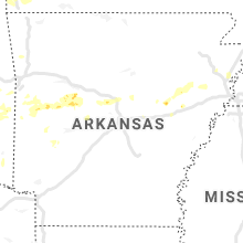


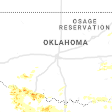


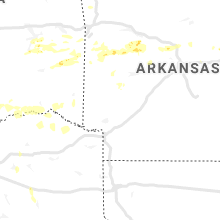


Cities Most Affected by Hail Storms of 5/22/2020
| Hail Size | Demographics of Zip Codes Affected | ||||||
|---|---|---|---|---|---|---|---|
| City | Count | Average | Largest | Pop Density | House Value | Income | Age |
| Burkburnett, TX | 5 | 2.92 | 5.33 | 148 | $64k | $38.5k | 38.2 |
| Wichita Falls, TX | 5 | 1.95 | 2.75 | 280 | $58k | $31.5k | 37.2 |
| Davidson, OK | 3 | 2.83 | 4.00 | 1 | $22k | $28.9k | 46.1 |
| Bowie, TX | 4 | 1.88 | 2.00 | 26 | $56k | $31.5k | 43.2 |
| Heavener, OK | 2 | 2.25 | 2.75 | 27 | $43k | $25.6k | 32.0 |
| Bellevue, TX | 2 | 2.13 | 2.50 | 5 | $38k | $33.9k | 46.2 |
| Estill, SC | 1 | 2.75 | 2.75 | 27 | $49k | $23.7k | 37.8 |
| Petrolia, TX | 1 | 2.75 | 2.75 | 1 | $35k | $27.8k | 40.3 |
| Daisy, GA | 1 | 2.00 | 2.00 | 0 | $65k | $23.1k | 42.0 |
| Ridgeland, SC | 1 | 1.75 | 1.75 | 50 | $77k | $30.2k | 34.8 |
| Preston, GA | 1 | 1.75 | 1.75 | 11 | $49k | $28.5k | 39.9 |
| Claxton, GA | 1 | 1.75 | 1.75 | 54 | $69k | $25.7k | 36.3 |
| Laurel, MS | 1 | 1.75 | 1.75 | 95 | $65k | $30.7k | 39.5 |
| Fort Cobb, OK | 1 | 1.75 | 1.75 | 9 | $42k | $27.2k | 45.2 |
| Mansfield, AR | 1 | 1.75 | 1.75 | 29 | $51k | $30.6k | 38.7 |
| Fairfax, SC | 1 | 1.75 | 1.75 | 16 | $49k | $21.7k | 38.9 |
| Greenwood, AR | 1 | 1.75 | 1.75 | 150 | $79k | $37.5k | 36.8 |
| Cumming, GA | 1 | 1.75 | 1.75 | 994 | $159k | $60.9k | 36.1 |
| Montevallo, AL | 1 | 1.75 | 1.75 | 107 | $98k | $38.5k | 32.4 |
| Horton, AL | 1 | 1.75 | 1.75 | 95 | $72k | $27.5k | 35.2 |
Hail and Wind Damage Spotted on 5/22/2020
Filter by Report Type:Hail ReportsWind Reports
States Impacted
Oklahoma, Missouri, Arkansas, Georgia, South Carolina, North Carolina, Florida, Alabama, Mississippi, Tennessee, Texas, KansasOklahoma
| Local Time | Report Details |
|---|---|
| 8:55 AM CDT | Em reports electric line down in vian. time estimated from rada in sequoyah county OK, 32 miles WNW of Fort Smith, AR |
| 5:17 PM CDT | Quarter sized hail reported near Hollister, OK, 36.5 miles NW of Wichita Falls, TX |
| 5:26 PM CDT | Grapefruit sized hail reported near Davidson, OK, 34.9 miles NW of Wichita Falls, TX |
| 5:35 PM CDT | Hen Egg sized hail reported near Davidson, OK, 33.2 miles NW of Wichita Falls, TX |
| 5:40 PM CDT | Ping Pong Ball sized hail reported near Frederick, OK, 33.2 miles NW of Wichita Falls, TX |
| 5:52 PM CDT | Quarter sized hail reported near Grandfield, OK, 28.4 miles NW of Wichita Falls, TX |
| 5:52 PM CDT | Tennis Ball sized hail reported near Davidson, OK, 40.3 miles NW of Wichita Falls, TX |
| 6:11 PM CDT | Quarter sized hail reported near Cache, OK, 50.2 miles N of Wichita Falls, TX |
| 6:15 PM CDT | Quarter sized hail reported near Indiahoma, OK, 51.1 miles NNW of Wichita Falls, TX |
| 7:48 PM CDT | Quarter sized hail reported near Howe, OK, 32.4 miles SSW of Fort Smith, AR |
| 8:01 PM CDT | Quarter sized hail reported near Wister, OK, 33.2 miles SSW of Fort Smith, AR |
| 8:07 PM CDT | Quarter sized hail reported near Lawton, OK, 60.2 miles N of Wichita Falls, TX |
| 8:22 PM CDT | Ping Pong Ball sized hail reported near Heavener, OK, 39 miles SSW of Fort Smith, AR |
| 8:25 PM CDT | Quarter sized hail reported near Carnegie, OK, 70.7 miles N of Wichita Falls, TX |
| 8:32 PM CDT | Baseball sized hail reported near Heavener, OK, 35.6 miles SSW of Fort Smith, AR |
| 8:32 PM CDT | Golf Ball sized hail reported near Heavener, OK, 36.9 miles SSW of Fort Smith, AR |
| 8:56 PM CDT | Golf Ball sized hail reported near Fort Cobb, OK, 56.9 miles WSW of Oklahoma City, OK |
| 8:58 PM CDT | Ping Pong Ball sized hail reported near Devol, OK, 15.3 miles N of Wichita Falls, TX |
| 10:38 PM CDT | Quarter sized hail reported near Quinton, OK, 55.2 miles W of Fort Smith, AR |
| 10:55 PM CDT | Storm damage reported in love county OK, 69 miles E of Wichita Falls, TX |
| 12:34 AM CDT | Storm damage reported in bryan county OK, 30.5 miles SSW of Atoka, OK |
| 12:38 AM CDT | Large tree across highway 259 just north of sweet home road north of broken bo in mccurtain county OK, 51.8 miles W of Nashville, AR |
| 12:40 AM CDT | Storm damage reported in bryan county OK, 39.9 miles S of Atoka, OK |
| 12:40 AM CDT | Power pole down at main east of hwy 74 in bryan county OK, 35.9 miles SSW of Atoka, OK |
| 12:45 AM CDT | Storm damage reported in bryan county OK, 34.5 miles SSW of Atoka, OK |
| 1:56 AM CDT | Quarter sized hail reported near Pryor, OK, 42.2 miles E of Tulsa, OK |
Missouri
| Local Time | Report Details |
|---|---|
| 9:51 AM CDT | Quarter sized hail reported near Rocky Comfort, MO, 54.3 miles SW of Springfield, MO, up to quarter size now. |
| 9:21 PM CDT | Ping Pong Ball sized hail reported near Oregon, MO, 66.9 miles NNW of Kansas City, MO, reported as 1 mile north of richville on interstate 29. |
| 10:02 PM CDT | Quarter sized hail reported near Fillmore, MO, 67 miles NNW of Kansas City, MO |
| 10:10 PM CDT | Road sign blown down... tree leaves stripped... limbs down in the are in andrew county MO, 61.6 miles NNW of Kansas City, MO |
Arkansas
| Local Time | Report Details |
|---|---|
| 9:58 AM CDT | Tree damage reported and confirmed via picture on social media. time is estimated from rada in washington county AR, 57.9 miles NNE of Fort Smith, AR |
| 11:30 AM CDT | A few trees were blown down in the area with power outages in this location as wel in newton county AR, 78.8 miles SSE of Springfield, MO |
| 2:30 PM CDT | Trees down along hyw 49 near fair oak in cross county AR, 55.8 miles W of Memphis, TN |
| 3:03 PM CDT | Quarter sized hail reported near Des Arc, AR, 49.9 miles ENE of Little Rock, AR, quarter size hail was noted about four miles northeast of des arc. |
| 3:45 PM CDT | Public reported trees down and other wind damage in wynn in cross county AR, 42.3 miles W of Memphis, TN |
| 3:55 PM CDT | Camper flipped over turned near mile marker 12 on i5 in crittenden county AR, 19 miles NW of Memphis, TN |
| 4:10 PM CDT | Large trees fell on trailer and car in crittenden county AR, 25.2 miles WNW of Memphis, TN |
| 4:10 PM CDT | Grain bin damaged along hwy 6 in cross county AR, 28.5 miles WNW of Memphis, TN |
| 4:25 PM CDT | Grain bins damaged... roof taken off barn near dacus r in crittenden county AR, 5.4 miles WNW of Memphis, TN |
| 9:17 PM CDT | Ping Pong Ball sized hail reported near Hartford, AR, 25.2 miles S of Fort Smith, AR, report received via mping |
| 9:33 PM CDT | Golf Ball sized hail reported near Mansfield, AR, 24.4 miles SSE of Fort Smith, AR |
| 9:41 PM CDT | Quarter sized hail reported near Mansfield, AR, 24.6 miles SSE of Fort Smith, AR, quarter sized hail fell near mansfield. |
| 10:00 PM CDT | Quarter sized hail reported near Ola, AR, 57.1 miles WNW of Little Rock, AR |
| 10:13 PM CDT | Golf Ball sized hail reported near Greenwood, AR, 14.6 miles SE of Fort Smith, AR |
| 2:23 AM CDT | Half Dollar sized hail reported near El Paso, AR, 29.6 miles NNE of Little Rock, AR |
Georgia
| Local Time | Report Details |
|---|---|
| 12:42 PM EDT | The cherokee county emergency manager reported a tree blown down onto a vehicle and a mobile home causing significant damage. no injuries were reporte in cherokee county GA, 26.1 miles N of Atlanta, GA |
| 12:50 PM EDT | The cherokee county emergency manager reported 3 trees blown down along union hill roa in cherokee county GA, 30.6 miles N of Atlanta, GA |
| 12:59 PM EDT | The cherokee county emergency manager reported a tree blown down along aj land roa in cherokee county GA, 30.5 miles N of Atlanta, GA |
| 1:05 PM EDT | Half Dollar sized hail reported near Cumming, GA, 32.2 miles NNE of Atlanta, GA, the public reported hail the size of quaters to half-dollars near the polo golf and country club. |
| 1:10 PM EDT | Golf Ball sized hail reported near Cumming, GA, 35.6 miles NNE of Atlanta, GA, a trained spotter reported hail the size of golf balls 1 mile north of cumming. |
| 1:22 PM EDT | Powerlines down near the intersection of ga hwy 211 and winder hwy (ga-53) in hall county GA, 43.4 miles NE of Atlanta, GA |
| 1:35 PM EDT | Tree down along talmo trail in jackson county GA, 49.1 miles NE of Atlanta, GA |
| 1:37 PM EDT | 1 tree down along murphy road near pendergrass in jackson county GA, 46.9 miles NE of Atlanta, GA |
| 1:39 PM EDT | The highway department in jackson county reported a tree blown down across the roadway blocking both lanes on cottage loop near the intersection of highway 332 and broo in jackson county GA, 49.3 miles NE of Atlanta, GA |
| 1:40 PM EDT | 3 trees down along old gainesville hwy in pendergrass in jackson county GA, 49.7 miles NE of Atlanta, GA |
| 1:51 PM EDT | Tree down along dry pond road near i-85 in jackson county GA, 55.2 miles NE of Atlanta, GA |
| 1:53 PM EDT | Several trees down along plainview road. several more along deadwyler roa in jackson county GA, 54.8 miles ENE of Atlanta, GA |
| 2:04 PM EDT | The banks county highway department reported a tree blown down across highway 59 in front of the beaver dam baptist churc in banks county GA, 60.7 miles SW of Greenville, SC |
| 2:20 PM EDT | Quarter sized hail reported near Hull, GA, 64.3 miles SW of Greenville, SC, a coop observer 6 miles west of danielsville reported hail 1 inch in diameter. |
| 5:11 PM EDT | Large tree down on cotton hill roa in randolph county GA, 68.8 miles SSE of Auburn, AL |
| 5:27 PM EDT | Large tree down on us-82 along with several hundred power outages in the georgetown are in quitman county GA, 54.9 miles SSE of Auburn, AL |
| 5:38 PM EDT | Large tree down on phillip causey roa in worth county GA, 57.7 miles W of Douglas, GA |
| 5:49 PM EDT | Multiple trees down along valley road in lumpkin in stewart county GA, 55.3 miles SE of Auburn, AL |
| 5:49 PM EDT | City of lumpkin - multiple trees down along valley road... powerlines down on liberty street... tree down on outbuilding on broad street in stewart county GA, 55.4 miles SE of Auburn, AL |
| 5:55 PM EDT | Large oak split and fell on a house... damaging 2 cars as well near intersection of clark road and greenville s in meriwether county GA, 46.7 miles SSW of Atlanta, GA |
| 6:01 PM EDT | Tree down along moores store road in northern stewart co in stewart county GA, 50.4 miles ESE of Auburn, AL |
| 6:04 PM EDT | Several trees down just east of alvaton along hwy 362 in meriwether county GA, 40.8 miles SSW of Atlanta, GA |
| 6:13 PM EDT | Tree down at hwy 280 and cucumber road in sumter county GA, 73.3 miles ESE of Auburn, AL |
| 6:20 PM EDT | Golf Ball sized hail reported near Preston, GA, 66 miles ESE of Auburn, AL, emergency manager reports golf ball sized hail in downtown preston and also numerous trees down along highway 41 just north of preston. |
| 6:23 PM EDT | Trees down on canal street and powerlines down on on walnut street at the intersection of callaway street. several hundred power outages in the are in lee county GA, 79.4 miles WNW of Douglas, GA |
| 6:25 PM EDT | Trees down new york road between mossy dell road and raines lan in lee county GA, 76.1 miles WNW of Douglas, GA |
| 6:35 PM EDT | Emergency manager reports 4 trees down on powerlines within the city limits of ellavill in schley county GA, 73 miles ESE of Auburn, AL |
| 6:35 PM EDT | Emergency manager reports 4 trees down on powerlines northwest of ellavill in schley county GA, 68.5 miles ESE of Auburn, AL |
| 6:47 PM EDT | Tree down at hwy 30 and dupree road in sumter county GA, 73.4 miles ESE of Auburn, AL |
| 6:49 PM EDT | Tree down along leslie-lamar road in sumter county GA, 79.5 miles WNW of Douglas, GA |
| 6:51 PM EDT | Tree down along tallent store roa in sumter county GA, 76.8 miles ESE of Auburn, AL |
| 6:51 PM EDT | Tree down along north end of orchid driv in sumter county GA, 78.7 miles ESE of Auburn, AL |
| 7:40 PM EDT | Emergency manager reports several trees downa long highway 26 between elko and brown hill r in houston county GA, 73.8 miles NW of Douglas, GA |
| 7:58 PM EDT | Tree down at salem church road near mullis white roa in bleckley county GA, 69.4 miles NNW of Douglas, GA |
| 8:02 PM EDT | Tree down along hwy 112 in ne portion of county in bleckley county GA, 76.5 miles NNW of Douglas, GA |
| 8:24 PM EDT | 911 center reports numerous trees down along highway 96 near jeffersonvill in twiggs county GA, 86.7 miles NNW of Douglas, GA |
| 9:03 PM EDT | Emergency manager reports several trees down in pierce county near old alma rd and west horshoe rd. time based on rada in pierce county GA, 32.9 miles ESE of Douglas, GA |
| 9:51 PM EDT | Hen Egg sized hail reported near Daisy, GA, 43.6 miles W of Savannah, GA, pictures relayed via social media of hail up to two inches in diameter in daisy. |
| 9:52 PM EDT | Golf Ball sized hail reported near Claxton, GA, 44.5 miles W of Savannah, GA, media relayed report of golf ball sized hail at the intersection of highway 129 and highway 250. |
South Carolina
| Local Time | Report Details |
|---|---|
| 2:26 PM EDT | Power lines down on us 25 and blue ridge dr. time estimated from rada in greenville county SC, 8.6 miles E of Greenville, SC |
| 2:29 PM EDT | Tree down on jackson grove rd. time estimated from rada in greenville county SC, 16.7 miles NE of Greenville, SC |
| 2:30 PM EDT | Social media reported trees down on car off of coolidge ave in greenville county SC, 13.2 miles E of Greenville, SC |
| 2:35 PM EDT | Trained spotter reported fence sections blown down... along with 4 inch limbs from the top of trees...on feversham c in greenville county SC, 16.6 miles NE of Greenville, SC |
| 2:50 PM EDT | Emergency mngr reported trees and powerlines down near west georgia rd and hwy 418 in greenville county SC, 16.8 miles SE of Greenville, SC |
| 2:50 PM EDT | Trees down on halls bridge rd. time estimated from rada in spartanburg county SC, 36.5 miles NE of Greenville, SC |
| 2:55 PM EDT | Public reported 10-12 trees down on windover l in greenville county SC, 23.2 miles ESE of Greenville, SC |
| 3:00 PM EDT | Public reported trees down that damaged metal chain link fence on parris bridge rd and sandifer r in spartanburg county SC, 39.9 miles ENE of Greenville, SC |
| 3:01 PM EDT | Trees down on brice rd at chapel dr. time estimated from rada in spartanburg county SC, 36.7 miles E of Greenville, SC |
| 3:03 PM EDT | Large hardwood tree uprooted. time estimated from rada in spartanburg county SC, 39.5 miles ENE of Greenville, SC |
| 3:03 PM EDT | Trees down on elberton hwy at hwy 187. time estimated from rada in anderson county SC, 39.5 miles SSW of Greenville, SC |
| 3:20 PM EDT | Tree down on sc 18 at pleasant school rd. time estimated from rada in cherokee county SC, 45.1 miles W of Charlotte, NC |
| 3:20 PM EDT | Tree down on raintree ln at coach hill dr. time estimated from rada in cherokee county SC, 45.2 miles WSW of Charlotte, NC |
| 3:32 PM EDT | Multiple trees and some power lines down along jumping branch road and rambler lane. large tree uprooted onto power lines near mcentire and bridges. possible tornad in cherokee county SC, 35.4 miles WSW of Charlotte, NC |
| 3:35 PM EDT | Public reported multiple trees and power lines down in buffalo in union county SC, 52.9 miles E of Greenville, SC |
| 3:40 PM EDT | Public reported trees down on houses and power lines down on monarch mill in union county SC, 54.5 miles SW of Charlotte, NC |
| 3:40 PM EDT | Power lines down on sc 72 at cambridge st. extension in abbeville county SC, 46.4 miles SSE of Greenville, SC |
| 3:43 PM EDT | Public reported trees down and building knocked over on lilly d in york county SC, 23.9 miles WSW of Charlotte, NC |
| 3:46 PM EDT | Public reported trees down along lawrence r in york county SC, 24.8 miles WSW of Charlotte, NC |
| 3:55 PM EDT | Amateur radio reported trees down and a porta john tossed around along seaside rd... allison rd... brandt rd... and sassana r in york county SC, 18.6 miles SW of Charlotte, NC |
| 3:55 PM EDT | Trees down on brattonsville rd near chappell rd. time estimated from rada in york county SC, 31.6 miles SW of Charlotte, NC |
| 4:00 PM EDT | Amateur radio reported trees down along the highway 274 corrido in york county SC, 19.5 miles SW of Charlotte, NC |
| 4:08 PM EDT | Trees down on us 321 at sky line dr. time estimated from rada in chester county SC, 43 miles SSW of Charlotte, NC |
| 4:11 PM EDT | Trees down on sc 72 and 193 s. time esimated from rada in chester county SC, 33.2 miles SSW of Charlotte, NC |
| 4:14 PM EDT | Quarter sized hail reported near Aiken, SC, 22 miles NE of Augusta, GA, quarter size hail reported at a convenience store on us hwy 1 near exit 22 on interstate 20. |
| 4:30 PM EDT | *** 1 fatal *** corrects previous tstm wnd dmg report from springdale. charlotte media informed us that a fatality occurred when a tree and power pole fell on a motor v in lancaster county SC, 36.8 miles S of Charlotte, NC |
| 4:36 PM EDT | County dispatch reported trees and power lines down all over the count in lancaster county SC, 34.9 miles S of Charlotte, NC |
| 4:36 PM EDT | Power pole and lines down on us hwy 521 just south of lancaster. photo provided via social media. time estimate in lancaster county SC, 37.1 miles S of Charlotte, NC |
| 4:42 PM EDT | Trained spotter and assistant fire chief reported trees down at willie usher rd and robert usher rd... with estimated wind gusts around 60 mph. time estimate in lancaster county SC, 33.8 miles SSE of Charlotte, NC |
| 4:54 PM EDT | Spotter relayed a report from the public of a tree down on a vehicle on turnip seed rd east of heath springs. no injuries. photo shared via social media. exact location in lancaster county SC, 44.9 miles SSE of Charlotte, NC |
| 5:00 PM EDT | Trees reported down on hwy 265 about 1 mile east of jefferson... near fork cree in chesterfield county SC, 47.6 miles SE of Charlotte, NC |
| 5:04 PM EDT | Schp reported trees down at evans mill rd and zion church rd. time estimate in chesterfield county SC, 42.9 miles SE of Charlotte, NC |
| 5:05 PM EDT | Trees down at big creek rd and morris rd. time estimate in newberry county SC, 52.3 miles NNE of Augusta, GA |
| 5:16 PM EDT | Highway patrol reported tree in roadway at evans mill road and zion church roa in chesterfield county SC, 42.9 miles SE of Charlotte, NC |
| 5:20 PM EDT | Quarter sized hail reported near Columbia, SC, 74.1 miles NE of Augusta, GA, public reported quarter size hail. |
| 5:29 PM EDT | Highway patrol reported tree in roadway at green meadow dr and amicks ferry r in lexington county SC, 54.8 miles NE of Augusta, GA |
| 5:35 PM EDT | Schp reported trees down on green meadow dr. time estimate in lexington county SC, 55.2 miles NE of Augusta, GA |
| 5:39 PM EDT | Tree in roadway. report from sc highway patrol in marlboro county SC, 77.3 miles ESE of Charlotte, NC |
| 5:41 PM EDT | Tree on roadway. highway patrol report in marlboro county SC, 75.6 miles ESE of Charlotte, NC |
| 5:45 PM EDT | Large tree down in the area of mary's lane in the mccoll community in marlboro county SC, 77 miles ESE of Charlotte, NC |
| 6:04 PM EDT | Ping Pong Ball sized hail reported near Elloree, SC, 40.3 miles NW of Charleston, SC, ema reported quarter to ping pong ball sized hail along stumphole rd. time estimated by radar. |
| 6:04 PM EDT | Schp reported trees down on ashland rd and gardendale dr. time estimate in lexington county SC, 62.1 miles NE of Augusta, GA |
| 6:09 PM EDT | Sc highway patrol reported downed trees on elliotts landing rd at old river rd. time estimated by rada in clarendon county SC, 42.1 miles NW of Charleston, SC |
| 6:24 PM EDT | Quarter sized hail reported near Shaw A F B, SC, 59.5 miles NNW of Charleston, SC, air force weather observer at shaw afb near sumter observed one inch hail. |
| 6:44 PM EDT | Warning point reported tree down that brought down a powerline at the intersection of highway 278 and concord church road. time estimated based on rada in allendale county SC, 49 miles SE of Augusta, GA |
| 7:05 PM EDT | Golf Ball sized hail reported near Fairfax, SC, 55.6 miles SE of Augusta, GA, warning point reported golf ball sized hail in fairfax. |
| 7:10 PM EDT | Trees down near the intersection of belvedere dr and moncks corner r in orangeburg county SC, 23.1 miles NW of Charleston, SC |
| 7:24 PM EDT | Schp reported trees down on beacon tree rd at us hwy 178... north of bowman. time estimate in orangeburg county SC, 42.1 miles WNW of Charleston, SC |
| 7:40 PM EDT | Quarter sized hail reported near Holly Hill, SC, 29.6 miles WNW of Charleston, SC, orangeburg co em reported quarter size hail near the community of wells. time estimated. |
| 7:50 PM EDT | Baseball sized hail reported near Estill, SC, 47.6 miles N of Savannah, GA, social media report and picture of baseball sized hail at the corner of 4th street and lawton avenue. |
| 8:05 PM EDT | Quarter sized hail reported near Estill, SC, 45.6 miles N of Savannah, GA, media relayed video of hail approximately 1 inch in diameter. time estimated based on radar. |
| 8:40 PM EDT | Golf Ball sized hail reported near Ridgeland, SC, 39.3 miles N of Savannah, GA, spotter relayed report of quarter to golf ball sized hail. hail lasted approximately 5 minutes. |
| 1:01 AM EDT | Trees down on i-26 near mile marker 96. time estimated from rada in richland county SC, 61.9 miles NE of Augusta, GA |
| 1:01 AM EDT | Trees down on i-26 near mile marker 100. time estimated from rada in richland county SC, 62.9 miles NE of Augusta, GA |
| 1:07 AM EDT | Trees down at main street and i-20. time estimated from rada in richland county SC, 69.4 miles NE of Augusta, GA |
| 1:15 AM EDT | Trees down and blocking roadway at the intersection of oakcrest drive and windsor lake blvd. time estimated from rada in richland county SC, 72.7 miles NE of Augusta, GA |
| 1:17 AM EDT | Richland county reported trees and power lines down along leesburg road. time estimated from rada in richland county SC, 71.7 miles ENE of Augusta, GA |
| 1:42 AM EDT | Trees down near sc 261 and richbow road. time estimated from rada in sumter county SC, 65.6 miles NNW of Charleston, SC |
North Carolina
| Local Time | Report Details |
|---|---|
| 3:25 PM EDT | Social media reported trees down in mint hill in mecklenburg county NC, 10.7 miles ESE of Charlotte, NC |
| 3:45 PM EDT | Amateur radio reported trees down near crowders creek and sparrow springs r in gaston county NC, 25.3 miles W of Charlotte, NC |
| 3:50 PM EDT | 911 call center reported trees down along woodstream dr. possible tornad in gaston county NC, 20.1 miles W of Charlotte, NC |
| 3:50 PM EDT | Amateur radio reported trees down along ferguson ridge and crawford road in gaston county NC, 21.9 miles W of Charlotte, NC |
| 3:52 PM EDT | Emergency mngr reported trees down on houses... power lines down on briarcliff rd and union rd near gastonia municipal airport in gaston county NC, 18.3 miles W of Charlotte, NC |
| 3:53 PM EDT | Amateur radio reported trees down along queens and stagecoach road in gaston county NC, 21.1 miles W of Charlotte, NC |
| 3:55 PM EDT | Law enforcement reported numerous trees down from belmont to south poin in gaston county NC, 10.4 miles W of Charlotte, NC |
| 4:00 PM EDT | Public reported trees down on grand palisades pkwy in mecklenburg county NC, 15.6 miles SW of Charlotte, NC |
| 4:10 PM EDT | Social media reported a destroyed swing se in mecklenburg county NC, 10.3 miles SSW of Charlotte, NC |
| 4:15 PM EDT | Social media reported trees down near stonehaven in mecklenburg county NC, 6.1 miles SE of Charlotte, NC |
| 4:20 PM EDT | Public reported trees down on bounty ct in union county NC, 13.1 miles SSE of Charlotte, NC |
| 4:21 PM EDT | *** 1 fatal... 1 inj *** emergency management reported a tree down on a house on idlewood circle in mecklenburg county NC, 2.3 miles SSW of Charlotte, NC |
| 4:23 PM EDT | Amateur radio reported road blockage from down tree on s providence rd in union county NC, 21.6 miles SSE of Charlotte, NC |
| 4:35 PM EDT | Amateur radio reported trees down blocking providence road sout in union county NC, 25.5 miles SSE of Charlotte, NC |
| 4:43 PM EDT | Multiple trees down on griffin green boulevard & big lick rd in stanfield... n in stanly county NC, 25.3 miles E of Charlotte, NC |
| 5:00 PM EDT | Numerous trees down... power lines down... and power poles down across anson count in anson county NC, 45.3 miles ESE of Charlotte, NC |
| 5:11 PM EDT | Tree down on strand drive in albemarle... nc in stanly county NC, 43.5 miles E of Charlotte, NC |
| 5:18 PM EDT | Tree down on emerald shores rd and lillys bridge rd in pee dee... n in montgomery county NC, 43.5 miles E of Charlotte, NC |
| 5:18 PM EDT | Tree down on holiday dr and river rd in troy... n in montgomery county NC, 45.2 miles E of Charlotte, NC |
| 5:51 PM EDT | Tree on house. springs mill rd in laurel hill. no injuries reporte in scotland county NC, 79.9 miles ESE of Charlotte, NC |
| 5:56 PM EDT | Tree on house. midland way in laurinburg. no injuries reporte in scotland county NC, 83.6 miles ESE of Charlotte, NC |
| 5:56 PM EDT | Tree down on hwy 72 in laurinbur in scotland county NC, 83.2 miles SSW of Raleigh, NC |
| 5:56 PM EDT | Several trees down on south valley rd in southern pine in moore county NC, 60.3 miles SW of Raleigh, NC |
| 5:59 PM EDT | Tree on house. azure ct in laurinburg. no injuries reporte in scotland county NC, 83.6 miles ESE of Charlotte, NC |
| 6:02 PM EDT | 1 tree fell knocking down multiple powerline in scotland county NC, 81.5 miles ESE of Charlotte, NC |
| 6:02 PM EDT | Several trees down along dowd rd in carthag in moore county NC, 53.9 miles SW of Raleigh, NC |
| 6:21 PM EDT | Tree on house. lees mill rd in laurinburg. no injuries reporte in scotland county NC, 81.2 miles SSW of Raleigh, NC |
| 6:25 PM EDT | Social media report of tree down across the road in barker ten mile. time estimated via rada in robeson county NC, 67 miles WNW of Wilmington, NC |
| 6:27 PM EDT | Report from mping: 1-inch tree limbs broken; shingles blown of in cumberland county NC, 53.2 miles SSW of Raleigh, NC |
| 6:50 PM EDT | Tin roof peeled off possible carpor in sampson county NC, 53.4 miles S of Raleigh, NC |
| 6:55 PM EDT | 13 trees down across sampson county between 650pm and 702pm. most of the trees down were near the cities of clinton and rosebor in sampson county NC, 56.9 miles SSE of Raleigh, NC |
| 7:30 PM EDT | Numerous trees down in warsa in duplin county NC, 53.4 miles N of Wilmington, NC |
Florida
| Local Time | Report Details |
|---|---|
| 3:55 PM EDT | Multiple trees down on i-10 between mm 166 and 16 in gadsden county FL, 31.7 miles WNW of Tallahassee, FL |
| 3:55 PM EDT | Large tree down on flat creek road near the intersection of audie clark roa in gadsden county FL, 31.8 miles WNW of Tallahassee, FL |
| 4:10 PM EDT | Damage to carport metal sheet covering... and a toppled medium sized palm tree onto at naples estates off rattlesnake hammock road. winds in the general area gusted to in collier county FL, 4.6 miles ESE of Naples, FL |
| 5:02 PM EDT | Quarter sized hail reported near Cape Coral, FL, 35 miles NNW of Naples, FL, broadcast media relayed report and video of dime to quarter sized hail in cape coral. time estimated by radar. |
| 5:47 PM EDT | Quarter sized hail reported near Winter Garden, FL, 12.1 miles WNW of Orlando, FL, public report of dime to quarter size hail in winter garden. time estimated from radar. |
| 5:48 PM EDT | Quarter sized hail reported near Winter Garden, FL, 12.1 miles WNW of Orlando, FL, public reported nickel to quarter size hail falling in the crown point area of winter garden. |
| 5:50 PM EDT | Quarter sized hail reported near Orlando, FL, 9.3 miles NW of Orlando, FL, hail up to quarter size near the intersection of mccormick road and apopka-vineland road. from video posted to social media. |
| 6:00 PM EDT | Ham operator reports his jacaranda tree was blown over. time estimated by rada in pasco county FL, 49.8 miles N of Bradenton, FL |
| 7:34 PM EDT | Mesonet station xtam tampa bay cut j reported a peak gust of 60mp in gmz830 county FL, 18.9 miles N of Bradenton, FL |
| 7:42 PM EDT | Spotter estimated 60 mph winds with large 5 inch diameter branches dow in pinellas county FL, 20.5 miles N of Bradenton, FL |
| 7:42 PM EDT | Asos station kspg st peters alber in pinellas county FL, 19.2 miles N of Bradenton, FL |
Alabama
| Local Time | Report Details |
|---|---|
| 3:15 PM CDT | Trees down and small hail also reporte in butler county AL, 47.5 miles ESE of Camden, AL |
| 3:30 PM CDT | Quarter sized hail reported near Cusseta, AL, 15.4 miles ENE of Auburn, AL, photo via social media. |
| 3:50 PM CDT | Tree down on county road 5 in henry county AL, 68.3 miles SSE of Auburn, AL |
| 4:12 PM CDT | Quarter sized hail reported near Grady, AL, 56.2 miles SW of Auburn, AL, reported near the intersection of huffman rd and hwy 94. |
| 4:50 PM CDT | Quarter sized hail reported near Sylacauga, AL, 43.5 miles SE of Birmingham, AL, photo via social media. |
| 4:55 PM CDT | Half Dollar sized hail reported near Calera, AL, 26.3 miles S of Birmingham, AL, reported by off duty nws employee. |
| 4:55 PM CDT | Quarter sized hail reported near Calera, AL, 23.5 miles S of Birmingham, AL |
| 4:55 PM CDT | Golf Ball sized hail reported near Montevallo, AL, 26.3 miles S of Birmingham, AL, reported near calera middle school. |
| 4:55 PM CDT | Quarter sized hail reported near Talladega, AL, 39.7 miles ESE of Birmingham, AL, reported along hwy 21 near old talladega hwy. |
| 5:00 PM CDT | Quarter sized hail reported near Epes, AL, 62.9 miles SE of Starkville, MS, reported along hwy 39 near mile marker 5. |
| 5:05 PM CDT | Half Dollar sized hail reported near Talladega, AL, 45.5 miles E of Birmingham, AL, reported along hwy 77 at the waldo quick stop. |
| 5:10 PM CDT | Powerlines down on old hwy 280 near signal valley rd. time estimated by radar. winds below severe limit in shelby county AL, 16.1 miles SE of Birmingham, AL |
| 6:00 PM CDT | Quarter sized hail reported near Birmingham, AL, 1.1 miles W of Birmingham, AL, penny to quarter size hail reported near malfunction junction. |
| 6:07 PM CDT | Quarter sized hail reported near Birmingham, AL, 1.2 miles E of Birmingham, AL, photo via social media. |
| 8:31 PM CDT | Golf Ball sized hail reported near Horton, AL, 55.3 miles NNE of Birmingham, AL, golfball size hail was reported on oak grove road north of douglas. |
Mississippi
| Local Time | Report Details |
|---|---|
| 3:15 PM CDT | Tree down on a house off of carter av in jones county MS, 73.4 miles ESE of Jackson, MS |
| 3:35 PM CDT | Trees down on jasper county road 2 in jasper county MS, 69.6 miles ESE of Jackson, MS |
| 3:35 PM CDT | Golf Ball sized hail reported near Laurel, MS, 69.6 miles ESE of Jackson, MS, on jasper county road 23. |
Tennessee
| Local Time | Report Details |
|---|---|
| 4:30 PM CDT | Trees down on locke rd. near shelby forres in shelby county TN, 11.8 miles N of Memphis, TN |
| 4:30 PM CDT | House damage due to fallen tre in shelby county TN, 12.4 miles NNE of Memphis, TN |
| 4:30 PM CDT | Large tree fell on house near shelby forres in shelby county TN, 9 miles N of Memphis, TN |
| 4:35 PM CDT | Tree down across holmes street... landed on ca in shelby county TN, 5.8 miles ESE of Memphis, TN |
| 4:37 PM CDT | Tree uprooted at residents hom in shelby county TN, 17.1 miles ENE of Memphis, TN |
| 4:37 PM CDT | Numerous trees down around arlington... some homes with shingles removed. powerlines down across airline r in shelby county TN, 23.8 miles ENE of Memphis, TN |
| 4:40 PM CDT | Trees and powerlines down across shadowlawn rd. near bartlett freshman academ in shelby county TN, 15.2 miles ENE of Memphis, TN |
| 4:41 PM CDT | Trees uprooted/snapped... shingles blown off roo in shelby county TN, 17.1 miles ENE of Memphis, TN |
| 4:49 PM CDT | Large tree snapped at base near the pink palace in memphi in shelby county TN, 4.1 miles ESE of Memphis, TN |
| 5:35 PM CDT | Power poles broken with numerous trees dow in tipton county TN, 22.6 miles NE of Memphis, TN |
| 7:10 PM CDT | Roof blown off of a carport as well as tree damage. time estimated from rada in williamson county TN, 28.2 miles SW of Nashville, TN |
| 7:10 PM CDT | Roof blown off of a carport as well as tree damage. time estimated from rada in williamson county TN, 28.2 miles SW of Nashville, TN |
Texas
| Local Time | Report Details |
|---|---|
| 6:29 PM CDT | Tea Cup sized hail reported near Burkburnett, TX, 17.8 miles NW of Wichita Falls, TX |
| 6:30 PM CDT | Half Dollar sized hail reported near Burkburnett, TX, 14 miles NNW of Wichita Falls, TX |
| 6:40 PM CDT | Softball sized hail reported near Burkburnett, TX, 12.3 miles NNW of Wichita Falls, TX |
| 6:43 PM CDT | Ping Pong Ball sized hail reported near Aspermont, TX, 55.2 miles NNW of Abilene, TX |
| 6:46 PM CDT | Quarter sized hail reported near Burkburnett, TX, 11.5 miles NNW of Wichita Falls, TX |
| 6:49 PM CDT | Golf Ball sized hail reported near Burkburnett, TX, 12.3 miles NNW of Wichita Falls, TX |
| 6:50 PM CDT | Baseball sized hail reported near Burkburnett, TX, 12.3 miles NNW of Wichita Falls, TX |
| 7:00 PM CDT | Half Dollar sized hail reported near Aspermont, TX, 55.2 miles NNW of Abilene, TX, estimated marble to ping pong ball size hail |
| 7:03 PM CDT | Golf Ball sized hail reported near Burkburnett, TX, 10.7 miles NNW of Wichita Falls, TX |
| 7:05 PM CDT | Ping Pong Ball sized hail reported near Wichita Falls, TX, 16.8 miles NE of Wichita Falls, TX |
| 7:17 PM CDT | Rfd wind... powerlines downed in wichita county TX, 7.8 miles NNW of Wichita Falls, TX |
| 7:23 PM CDT | Storm damage reported in clay county TX, 12.1 miles NE of Wichita Falls, TX |
| 7:28 PM CDT | Baseball sized hail reported near Wichita Falls, TX, 12.6 miles NNE of Wichita Falls, TX |
| 7:35 PM CDT | Quarter sized hail reported near Van, TX, 69.7 miles ESE of Dallas, TX |
| 7:52 PM CDT | Sheppard afb asos in wichita county TX, 1.4 miles SSW of Wichita Falls, TX |
| 7:52 PM CDT | Ping Pong Ball sized hail reported near Wichita Falls, TX, 1.4 miles SSW of Wichita Falls, TX, i-44/riley rd. |
| 7:53 PM CDT | Golf Ball sized hail reported near Wichita Falls, TX, 1.4 miles SSW of Wichita Falls, TX |
| 7:57 PM CDT | Sheppard afb in wichita county TX, 1.4 miles SSW of Wichita Falls, TX |
| 7:59 PM CDT | Golf Ball sized hail reported near Wichita Falls, TX, 1.4 miles SSW of Wichita Falls, TX, iowa park rd just north of i-44 |
| 8:00 PM CDT | Golf Ball sized hail reported near Wichita Falls, TX, 2.1 miles SW of Wichita Falls, TX |
| 8:02 PM CDT | Baseball sized hail reported near Petrolia, TX, 17.1 miles ENE of Wichita Falls, TX |
| 8:05 PM CDT | Golf Ball sized hail reported near Wichita Falls, TX, 2 miles SSW of Wichita Falls, TX |
| 8:05 PM CDT | East side of wichita falls in wichita county TX, 1.4 miles SSW of Wichita Falls, TX |
| 8:08 PM CDT | Half Dollar sized hail reported near Burkburnett, TX, 10.7 miles NNW of Wichita Falls, TX |
| 8:09 PM CDT | Tennis Ball sized hail reported near Bellevue, TX, 34.5 miles SE of Wichita Falls, TX |
| 8:20 PM CDT | Golf Ball sized hail reported near Bowie, TX, 38.7 miles ESE of Wichita Falls, TX, golf ball size hail at bullard rd near hwy 287. |
| 8:21 PM CDT | Quarter sized hail reported near Wichita Falls, TX, 8.7 miles E of Wichita Falls, TX |
| 8:24 PM CDT | Quarter sized hail reported near Henrietta, TX, 10 miles E of Wichita Falls, TX |
| 8:37 PM CDT | Quarter sized hail reported near Bellevue, TX, 33.7 miles SE of Wichita Falls, TX |
| 8:37 PM CDT | Hen Egg sized hail reported near Bowie, TX, 45.5 miles ESE of Wichita Falls, TX, 2 inch hail reported around pelham street and lee street in bowie. |
| 8:38 PM CDT | Golf Ball sized hail reported near Bellevue, TX, 35 miles SE of Wichita Falls, TX |
| 8:48 PM CDT | Ping Pong Ball sized hail reported near Bellevue, TX, 35.9 miles SE of Wichita Falls, TX |
| 9:03 PM CDT | Spotter estimated 60 mph wind gusts and tree limbs down southwest of bowi in montague county TX, 44.3 miles SE of Wichita Falls, TX |
| 9:18 PM CDT | Building damage reported near 81 and hwy 28 in montague county TX, 45.8 miles ESE of Wichita Falls, TX |
| 9:18 PM CDT | Hen Egg sized hail reported near Bowie, TX, 41.5 miles ESE of Wichita Falls, TX, trained spotter reported 2 inch hail northwest of bowie. |
| 9:31 PM CDT | Trained spotter reporting tree limbs and other debris in the roa in montague county TX, 48.3 miles SE of Wichita Falls, TX |
| 9:34 PM CDT | Golf Ball sized hail reported near Bowie, TX, 46.6 miles SE of Wichita Falls, TX, golf ball hail reported near the intersection between jack... clay... and wise counties. |
| 9:41 PM CDT | Trained spotters report tree and building damage with power out throughout the are in montague county TX, 45 miles ESE of Wichita Falls, TX |
| 10:40 PM CDT | Quarter sized hail reported near Archer City, TX, 23.2 miles SSW of Wichita Falls, TX |
| 10:43 PM CDT | Quarter sized hail reported near Holliday, TX, 12.8 miles WSW of Wichita Falls, TX |
| 10:51 PM CDT | Quarter sized hail reported near Bowie, TX, 36.9 miles SSE of Wichita Falls, TX, quarter size hail reported east of shannon by a trained spotter. |
| 11:15 PM CDT | Reports of 8 inch diameter tree limbs down 5 miles east of forestbur in montague county TX, 61.7 miles ESE of Wichita Falls, TX |
| 11:18 PM CDT | Quarter sized hail reported near Holliday, TX, 19.7 miles WSW of Wichita Falls, TX |
| 11:20 PM CDT | (delayed report) emergency management reports large trees down blocking the road north of bridgepor in wise county TX, 62.7 miles SE of Wichita Falls, TX |
| 11:22 PM CDT | Reports of damage to power poles and trees in whitesbor in grayson county TX, 61.2 miles N of Dallas, TX |
| 11:36 PM CDT | Emergency management reports metal roofing pulled off an apartment complex in whitesbor in grayson county TX, 61.1 miles N of Dallas, TX |
| 11:58 PM CDT | Quarter sized hail reported near Jacksboro, TX, 49 miles SSE of Wichita Falls, TX, reports of quarter size hail and water over the roadway on hwy 281. |
| 12:20 AM CDT | Emergency management reports trees down... damage to a few rvs... and power lines around us 82 near the oak ridge area eastwar in cooke county TX, 63.9 miles NNW of Dallas, TX |
| 12:35 AM CDT | Emergency management reports metal roof torn off manufactured home near us377/fm901 near sandusk in grayson county TX, 60.9 miles SW of Atoka, OK |
Kansas
| Local Time | Report Details |
|---|---|
| 8:10 PM CDT | Quarter sized hail reported near Morrill, KS, 69.3 miles NE of Manhattan, KS, nickel to quarter size hail in morrill. |
Connect with Interactive Hail Maps