

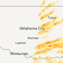
Hail Map for Thursday, April 14, 2011

Number of Impacted Households on 4/14/2011
0
Impacted by 1" or Larger Hail
0
Impacted by 1.75" or Larger Hail
0
Impacted by 2.5" or Larger Hail
Square Miles of Populated Area Impacted on 4/14/2011
0
Impacted by 1" or Larger Hail
0
Impacted by 1.75" or Larger Hail
0
Impacted by 2.5" or Larger Hail


Cities Most Affected by Hail Storms of 4/14/2011
| Hail Size | Demographics of Zip Codes Affected | ||||||
|---|---|---|---|---|---|---|---|
| City | Count | Average | Largest | Pop Density | House Value | Income | Age |
| Tishomingo, OK | 1 | 4.25 | 4.25 | 28 | $47k | $24.6k | 37.4 |
| Roff, OK | 1 | 4.25 | 4.25 | 6 | $33k | $26.3k | 39.5 |
| Clayton, OK | 1 | 4.25 | 4.25 | 3 | $34k | $20.9k | 43.2 |
| Sulphur, OK | 1 | 4.25 | 4.25 | 43 | $53k | $30.6k | 41.9 |
| Moyers, OK | 1 | 4.25 | 4.25 | 2 | $39k | $26.5k | 52.0 |
| Coleman, OK | 1 | 4.00 | 4.00 | 12 | $45k | $28.2k | 40.3 |
| Coweta, OK | 2 | 1.88 | 2.00 | 169 | $81k | $40.2k | 35.3 |
| Davis, OK | 2 | 1.88 | 2.00 | 20 | $51k | $30.4k | 39.6 |
| Hatfield, AR | 2 | 1.75 | 1.75 | 16 | $45k | $24.4k | 43.1 |
| Mill Creek, OK | 2 | 1.75 | 1.75 | 4 | $32k | $29.2k | 40.5 |
| Madill, OK | 1 | 2.50 | 2.50 | 31 | $45k | $25.0k | 37.1 |
| Chautauqua, KS | 1 | 2.50 | 2.50 | 0 | $26k | $19.6k | 50.0 |
| Mena, AR | 1 | 2.00 | 2.00 | 24 | $61k | $25.4k | 45.5 |
| Sachse, TX | 1 | 2.00 | 2.00 | 2072 | $124k | $70.7k | 35.4 |
| Hope, AR | 1 | 1.75 | 1.75 | 57 | $54k | $28.5k | 35.8 |
| Garland, TX | 1 | 1.75 | 1.75 | 3914 | $83k | $51.7k | 32.8 |
| Texarkana, AR | 1 | 1.75 | 1.75 | 133 | $64k | $31.1k | 37.2 |
| Leonard, TX | 1 | 1.75 | 1.75 | 43 | $63k | $37.5k | 39.5 |
| Pawnee, OK | 1 | 1.75 | 1.75 | 15 | $42k | $29.2k | 40.7 |
| Roanoke, TX | 1 | 1.75 | 1.75 | 675 | $169k | $77.9k | 36.1 |
| Holdenville, OK | 1 | 1.75 | 1.75 | 25 | $33k | $21.7k | 37.8 |
| Benton, AR | 1 | 1.75 | 1.75 | 149 | $0k | $0.0k | 38.9 |
| Hominy, OK | 1 | 1.75 | 1.75 | 12 | $42k | $25.0k | 37.9 |
| North Little Rock, AR | 1 | 1.75 | 1.75 | 3400 | $110k | $50.6k | 41.8 |
| Wilburton, OK | 1 | 1.75 | 1.75 | 17 | $47k | $22.9k | 37.5 |
| Wister, OK | 1 | 1.75 | 1.75 | 11 | $42k | $27.4k | 40.3 |
| Gainesville, TX | 1 | 1.75 | 1.75 | 74 | $70k | $35.5k | 38.3 |
| Hot Springs National Park, AR | 1 | 1.75 | 1.75 | 295 | $73k | $26.0k | 41.1 |
| Whitesboro, TX | 1 | 1.75 | 1.75 | 44 | $69k | $35.6k | 41.2 |
| Nashoba, OK | 1 | 1.75 | 1.75 | 4 | $43k | $20.3k | 47.8 |
| Bartlesville, OK | 1 | 1.75 | 1.75 | 122 | $37k | $25.8k | 36.8 |
Hail and Wind Damage Spotted on 4/14/2011
Filter by Report Type:Hail ReportsWind Reports
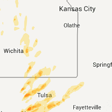
States Impacted
Kansas, Oklahoma, Nebraska, Texas, Missouri, Arkansas, Alabama, Louisiana, Tennessee, MississippiKansas
| Local Time | Report Details |
|---|---|
| 4:43 PM UTC | Quarter sized hail reported near Goodland, KS, 36 miles W of Colby, KS |
| 7:50 PM UTC | Quarter sized hail reported near Burr Oak, KS, 70.2 miles S of Grand Island, NE, mainly pea size with a few quarters. hail covered the ground. |
| 8:50 PM UTC | Quarter sized hail reported near Lorraine, KS, 58.5 miles ESE of Hays, KS, reported by kwch storm chaser. |
| 8:55 PM UTC | Quarter sized hail reported near Lorraine, KS, 57 miles ESE of Hays, KS |
| 9:00 PM UTC | Quarter sized hail reported near Tescott, KS, 71.8 miles W of Manhattan, KS, time estimated |
| 9:08 PM UTC | Quarter sized hail reported near McPherson, KS, 50.1 miles NNW of Wichita, KS, trained spotter estimated hail a little bigger than quarter sized. |
| 9:09 PM UTC | Quarter sized hail reported near Ellsworth, KS, 60.4 miles E of Hays, KS, trained spotter reported hail a little bigger than quarter sized. |
| 9:14 PM UTC | Half Dollar sized hail reported near Ellsworth, KS, 60.2 miles E of Hays, KS |
| 9:22 PM UTC | Quarter sized hail reported near Atlanta, KS, 35.4 miles ESE of Wichita, KS |
| 9:30 PM UTC | Quarter sized hail reported near Smith Center, KS, 69.3 miles NNE of Hays, KS |
| 9:31 PM UTC | Half Dollar sized hail reported near Ellsworth, KS, 65.5 miles E of Hays, KS |
| 9:40 PM UTC | Quarter sized hail reported near Ellsworth, KS, 66.5 miles E of Hays, KS, at i-70/highway 156 interchange. |
| 9:40 PM UTC | Half Dollar sized hail reported near Lincoln, KS, 59.4 miles E of Hays, KS, emergency manager reports half dollar hail at k14 and i70 with smaller hail covering ground. |
| 9:44 PM UTC | Quarter sized hail reported near Augusta, KS, 25 miles E of Wichita, KS, hail reported at 5 east and 2 south of augusta. |
| 9:54 PM UTC | Half Dollar sized hail reported near El Dorado, KS, 27.6 miles ENE of Wichita, KS |
| 10:00 PM UTC | Near the ottawa/saline county line on brookville road. roof blown off of house. shed not tied down to foundation completely blown down and motorcyle thrown approx 30 mi in ottawa county KS, 72.2 miles W of Manhattan, KS |
| 10:00 PM UTC | Near the ottawa/saline county line on brookville road. roof blown off of house. shed not tied down to foundation completely blown down and motorcyle thrown approx 30 ya in ottawa county KS, 72.2 miles W of Manhattan, KS |
| 10:00 PM UTC | Quarter sized hail reported near Portis, KS, 58.7 miles NE of Hays, KS |
| 10:05 PM UTC | Half Dollar sized hail reported near Burr Oak, KS, 70.2 miles S of Grand Island, NE |
| 10:06 PM UTC | Quarter sized hail reported near El Dorado, KS, 31.3 miles NE of Wichita, KS |
| 10:15 PM UTC | Tennis Ball sized hail reported near Chautauqua, KS, 60.8 miles SW of Chanute, KS |
| 10:20 PM UTC | Quarter sized hail reported near Gypsum, KS, 51.5 miles SW of Manhattan, KS |
| 10:22 PM UTC | Quarter sized hail reported near Abilene, KS, 44 miles SW of Manhattan, KS |
| 10:25 PM UTC | Half Dollar sized hail reported near Gaylord, KS, 62.6 miles NNE of Hays, KS, ground mostly covered with hail. |
| 10:27 PM UTC | Quarter sized hail reported near Abilene, KS, 44 miles SW of Manhattan, KS, pea to quarter sized hail. |
| 10:30 PM UTC | Off duty nws employee estimates 60 mph with the rfd of the thunderstorm producing the funnel clou in chautauqua county KS, 54.7 miles SW of Chanute, KS |
| 10:33 PM UTC | Quarter sized hail reported near Abilene, KS, 39.2 miles WSW of Manhattan, KS, quarter sized hail in abilene |
| 10:35 PM UTC | Quarter sized hail reported near Beloit, KS, 77.6 miles ENE of Hays, KS |
| 10:40 PM UTC | Quarter sized hail reported near Abilene, KS, 42.2 miles WSW of Manhattan, KS |
| 10:50 PM UTC | Storm damage reported in greenwood county KS, 50.5 miles W of Chanute, KS |
| 10:58 PM UTC | Spotter estimated winds of 60-70 mph with pea sized hail in geary county KS, 25.2 miles SW of Manhattan, KS |
| 11:02 PM UTC | Quarter sized hail reported near Elk City, KS, 37 miles SW of Chanute, KS |
| 11:10 PM UTC | Quarter sized hail reported near Eureka, KS, 42.1 miles WNW of Chanute, KS, kwch storm chaser reporting quarter hail and a wall cloud 2 miles east of k99 and us54. |
| 11:15 PM UTC | Quarter sized hail reported near Council Grove, KS, 38.1 miles S of Manhattan, KS, covering the ground along highway 177. |
| 11:19 PM UTC | Also pea size hail in wabaunsee county KS, 23 miles S of Manhattan, KS |
| 11:25 PM UTC | Trained spotter reports 8 inch diameter tree limbs dow in montgomery county KS, 34.3 miles SSW of Chanute, KS |
| 11:45 PM UTC | 2 to 3 inch diameter limbs dow in marshall county KS, 54.1 miles N of Manhattan, KS |
| 11:48 PM UTC | Multiple reports of 60 to 70 mph winds from mound valley to dennis to parson in labette county KS, 23 miles S of Chanute, KS |
| 11:48 PM UTC | Trained spotter reports 60mph winds with gusts to 75 mph wind in labette county KS, 24.6 miles S of Chanute, KS |
| 11:48 PM UTC | Kwch storm chaser reports 5 to 6 inch diameter tree limbs down passing through independence on us 7 in montgomery county KS, 34.3 miles SSW of Chanute, KS |
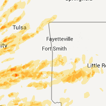
Oklahoma
| Local Time | Report Details |
|---|---|
| 8:50 PM UTC | Quarter sized hail reported near Davis, OK, 57.7 miles W of Atoka, OK |
| 9:00 PM UTC | Hen Egg sized hail reported near Davis, OK, 57.2 miles W of Atoka, OK, the hail was reported on the north side of town |
| 4:08 PM CDT | Golf Ball sized hail reported near Pawnee, OK, 46.9 miles WNW of Tulsa, OK |
| 9:18 PM UTC | Quarter sized hail reported near Skedee, OK, 42.5 miles WNW of Tulsa, OK |
| 9:21 PM UTC | Half Dollar sized hail reported near Hickory, OK, 43.5 miles WNW of Atoka, OK |
| 9:27 PM UTC | Quarter sized hail reported near Fairfax, OK, 46.7 miles NW of Tulsa, OK |
| 9:30 PM UTC | Quarter sized hail reported near Shawnee, OK, 35.1 miles ESE of Oklahoma City, OK |
| 9:30 PM UTC | Grapefruit sized hail reported near Sulphur, OK, 49.4 miles W of Atoka, OK, mainly quarter sized hail with a few softball sized pieces. report relayed via sulphur police department. |
| 9:40 PM UTC | Small trees blown dow in lincoln county OK, 47.8 miles SW of Tulsa, OK |
| 9:45 PM UTC | Quarter sized hail reported near Tecumseh, OK, 30.8 miles ESE of Oklahoma City, OK |
| 9:46 PM UTC | Storm damage reported in lincoln county OK, 46.4 miles SW of Tulsa, OK |
| 4:51 PM CDT | Quarter sized hail reported near Hominy, OK, 28.5 miles NW of Tulsa, OK |
| 4:53 PM CDT | Golf Ball sized hail reported near Hominy, OK, 28.5 miles NW of Tulsa, OK |
| 9:54 PM UTC | Quarter sized hail reported near Shamrock, OK, 36.8 miles WSW of Tulsa, OK |
| 9:55 PM UTC | Quarter sized hail reported near Prague, OK, 46.8 miles E of Oklahoma City, OK |
| 9:58 PM UTC | Storm damage reported in osage county OK, 28.5 miles NW of Tulsa, OK |
| 10:00 PM UTC | Storm damage reported in pawnee county OK, 32.7 miles W of Tulsa, OK |
| 10:00 PM UTC | Homes damaged - possible tornado in osage county OK, 30.8 miles NW of Tulsa, OK |
| 10:00 PM UTC | Quarter sized hail reported near Ardmore, OK, 65.1 miles WSW of Atoka, OK, public report of quarter sized hail. |
| 10:00 PM UTC | Grapefruit sized hail reported near Roff, OK, 44 miles WNW of Atoka, OK |
| 10:01 PM UTC | Telephone poles down over roa in osage county OK, 29.8 miles NW of Tulsa, OK |
| 10:04 PM UTC | Storm damage reported in osage county OK, 31.7 miles NW of Tulsa, OK |
| 10:07 PM UTC | Golf Ball sized hail reported near Sulphur, OK, 49.1 miles W of Atoka, OK |
| 10:15 PM UTC | Golf Ball sized hail reported near Mill Creek, OK, 41.8 miles W of Atoka, OK |
| 10:24 PM UTC | Half Dollar sized hail reported near Sapulpa, OK, 19.2 miles WSW of Tulsa, OK |
| 10:40 PM UTC | Half Dollar sized hail reported near Sapulpa, OK, 15.1 miles SW of Tulsa, OK |
| 10:41 PM UTC | Quarter sized hail reported near Castle, OK, 43.1 miles SSW of Tulsa, OK |
| 5:41 PM CDT | Ping Pong Ball sized hail reported near Sapulpa, OK, 11.6 miles SW of Tulsa, OK |
| 10:45 PM UTC | Quarter sized hail reported near Prague, OK, 47.5 miles E of Oklahoma City, OK |
| 10:45 PM UTC | Large tree down onto power line in creek county OK, 12.2 miles SSW of Tulsa, OK |
| 10:47 PM UTC | Several trees downed near lone star school on hickory road in creek county OK, 14 miles SSW of Tulsa, OK |
| 5:55 PM CDT | Quarter sized hail reported near Bartlesville, OK, 41.4 miles N of Tulsa, OK |
| 5:58 PM CDT | Golf Ball sized hail reported near Bartlesville, OK, 41.4 miles N of Tulsa, OK |
| 11:00 PM UTC | Tennis Ball sized hail reported near Madill, OK, 43.1 miles WSW of Atoka, OK |
| 11:06 PM UTC | Quarter sized hail reported near Boley, OK, 53.1 miles SSW of Tulsa, OK |
| 11:14 PM UTC | Quarter sized hail reported near Boley, OK, 52.2 miles SSW of Tulsa, OK |
| 11:20 PM UTC | Quarter sized hail reported near Tupelo, OK, 24.9 miles NW of Atoka, OK |
| 6:23 PM CDT | Grapefruit sized hail reported near Tishomingo, OK, 33.2 miles WSW of Atoka, OK |
| 11:25 PM UTC | Quarter sized hail reported near Wewoka, OK, 56.1 miles NNW of Atoka, OK, quarter sized hail reported in downtown wewoka. time estimated via radar. |
| 11:36 PM UTC | 4 to 5 inch diameter...5 to 6 feet long tree limb dow in rogers county OK, 15.5 miles ENE of Tulsa, OK |
| 11:38 PM UTC | Golf Ball sized hail reported near Holdenville, OK, 55.6 miles NNW of Atoka, OK, delayed report from emergency manager. |
| 11:39 PM UTC | Quarter sized hail reported near Owasso, OK, 17.1 miles NE of Tulsa, OK |
| 11:45 PM UTC | Grapefruit sized hail reported near Coleman, OK, 22.7 miles WSW of Atoka, OK |
| 11:58 PM UTC | Wind gust estimated about 1 mile north of rogers state university in rogers county OK, 24.6 miles ENE of Tulsa, OK |
| 12:01 AM UTC | Ping Pong Ball sized hail reported near McAlester, OK, 36.5 miles NNE of Atoka, OK, reported at the toll gate |
| 12:05 AM UTC | Golf Ball sized hail reported near Davis, OK, 57.2 miles W of Atoka, OK |
| 12:20 AM UTC | Quarter sized hail reported near Fittstown, OK, 34.9 miles WNW of Atoka, OK, delayed report from the public. |
| 7:21 PM CDT | Hen Egg sized hail reported near Coweta, OK, 23.6 miles SE of Tulsa, OK |
| 12:25 AM UTC | Quarter sized hail reported near McAlester, OK, 44.1 miles NNE of Atoka, OK |
| 7:39 PM CDT | Golf Ball sized hail reported near Coweta, OK, 23.6 miles SE of Tulsa, OK |
| 12:45 AM UTC | Quarter sized hail reported near Broken Arrow, OK, 18.2 miles ESE of Tulsa, OK |
| 12:51 AM UTC | Two trailer houses destroyed. power lines and trees down. one vehicle turned over on its roof. near cemetary about 3 west of eucha. possible tornad in delaware county OK, 65.4 miles ENE of Tulsa, OK |
| 1:00 AM UTC | Golf Ball sized hail reported near Mill Creek, OK, 39.6 miles W of Atoka, OK |
| 1:16 AM UTC | Grapefruit sized hail reported near Moyers, OK, 23.8 miles ENE of Atoka, OK, softball and baseball hail reported with tornado 5s daisy along indian nation turnpike |
| 1:16 AM UTC | Winds estimated 85 mph vicinity of tornado 5s daisy along indian nation turnpike in pushmataha county OK, 23.8 miles ENE of Atoka, OK |
| 1:22 AM UTC | Just northwest of wagoner roof almost completely removed from one house. several trees and fences down. about 1/2 mile southwest two barns damaged. about 1/2 mile north in wagoner county OK, 37.3 miles ESE of Tulsa, OK |
| 1:22 AM UTC | Quarter sized hail reported near Afton, OK, 67.5 miles ENE of Tulsa, OK |
| 1:24 AM UTC | Several barns and buildings had significant damage. location approximat in wagoner county OK, 36.4 miles ESE of Tulsa, OK |
| 1:31 AM UTC | Power lines and trees downed on west side of town. other possible damage but unable to survey due to debri in latimer county OK, 57.1 miles SW of Fort Smith, AR |
| 1:36 AM UTC | Quarter sized hail reported near Afton, OK, 71.9 miles ENE of Tulsa, OK, corrected for time a location |
| 1:46 AM UTC | Quarter sized hail reported near Bristow, OK, 31.3 miles SW of Tulsa, OK |
| 1:51 AM UTC | Grapefruit sized hail reported near Clayton, OK, 46.2 miles ENE of Atoka, OK, softball and baseball hail on highway 43 south side of sardis lake. |
| 2:13 AM UTC | Golf Ball sized hail reported near Wilburton, OK, 54.3 miles ENE of Atoka, OK, lots of hail of long duration with golfball size the largest |
| 2:17 AM UTC | Trees down. possible tornad in latimer county OK, 51.7 miles ENE of Atoka, OK |
| 2:22 AM UTC | Quarter sized hail reported near Clayton, OK, 46.6 miles ENE of Atoka, OK, nickel to quarter size hail. |
| 2:24 AM UTC | Golf Ball sized hail reported near Wister, OK, 33.2 miles SSW of Fort Smith, AR |
| 2:24 AM UTC | Storm damage reported in okmulgee county OK, 21.4 miles S of Tulsa, OK |
| 2:25 AM UTC | Quarter sized hail reported near Glenpool, OK, 13.8 miles S of Tulsa, OK |
| 2:30 AM UTC | Storm damage reported in le flore county OK, 31.5 miles SSW of Fort Smith, AR |
| 2:30 AM UTC | Barn destroyed...siding ripped off house...roof damage at 153rd and south ming in tulsa county OK, 4.3 miles ESE of Tulsa, OK |
| 2:35 AM UTC | Storm damage reported in le flore county OK, 31.5 miles SSW of Fort Smith, AR |
| 2:38 AM UTC | Roof damage to home in tulsa county OK, 19.2 miles SE of Tulsa, OK |
| 2:38 AM UTC | Barn heavily damaged. possible tornad in pushmataha county OK, 47.5 miles ENE of Atoka, OK |
| 2:40 AM UTC | Quarter sized hail reported near Tishomingo, OK, 30.1 miles WSW of Atoka, OK |
| 2:40 AM UTC | Golf Ball sized hail reported near Nashoba, OK, 52.8 miles E of Atoka, OK |
| 2:40 AM UTC | Numerous recreational vehicles blown over and into highwa in le flore county OK, 26.3 miles SSW of Fort Smith, AR |
| 2:45 AM UTC | Large trees down on us 271 and 4 star road. possible tornad in pushmataha county OK, 53.8 miles ENE of Atoka, OK |
| 2:49 AM UTC | 2 homes with roof damage and significant tree damage on nolia loop road east of nashoba. possible tornad in pushmataha county OK, 55.6 miles E of Atoka, OK |
| 2:51 AM UTC | Along highway 51 between 105st and 121st street numerous power poles blown down or broken...about a doze in wagoner county OK, 22.9 miles ESE of Tulsa, OK |
| 2:55 AM UTC | Storm damage reported in wagoner county OK, 26 miles ESE of Tulsa, OK |
| 2:56 AM UTC | Quarter sized hail reported near Broken Arrow, OK, 18.2 miles ESE of Tulsa, OK |
| 3:10 AM UTC | Quarter sized hail reported near Achille, OK, 41.2 miles SSW of Atoka, OK |
| 3:12 AM UTC | 3-4 inch diameter limbs dow in sequoyah county OK, 5.6 miles WNW of Fort Smith, AR |
| 10:16 PM CDT | Quarter sized hail reported near Chouteau, OK, 35.5 miles E of Tulsa, OK, dime to quarter hail |
| 3:20 AM UTC | Storm damage reported in mayes county OK, 35.5 miles E of Tulsa, OK |
| 10:21 PM CDT | Ping Pong Ball sized hail reported near Chouteau, OK, 35.5 miles E of Tulsa, OK |
| 3:27 AM UTC | Quarter sized hail reported near Heavener, OK, 61 miles SSW of Fort Smith, AR |
| 3:30 AM UTC | Travel trailer destroyed...shed destroyed...other wind damag in pushmataha county OK, 27.6 miles E of Atoka, OK |
| 3:30 AM UTC | Numerous trees and power lines reported down between oleta and sobol...also north of sobol. houses damaged. possible tornad in pushmataha county OK, 46.7 miles ESE of Atoka, OK |
| 3:36 AM UTC | Quarter sized hail reported near Watson, OK, 52.2 miles NW of Nashville, AR |
Nebraska
| Local Time | Report Details |
|---|---|
| 10:30 PM UTC | Quarter sized hail reported near Bruning, NE, 57.5 miles SE of Grand Island, NE |
Texas
| Local Time | Report Details |
|---|---|
| 1:13 AM UTC | Quarter sized hail reported near Gainesville, TX, 62.2 miles NNW of Dallas, TX, quarter size hail briefly on interstate 35 in gainesville |
| 1:40 AM UTC | Quarter sized hail reported near Whitesboro, TX, 60.5 miles N of Dallas, TX, quarter size hail in whitesboro |
| 1:59 AM UTC | Golf Ball sized hail reported near Gainesville, TX, 73 miles NNW of Dallas, TX, golfball size hail in moss lake |
| 2:04 AM UTC | Quarter sized hail reported near Myra, TX, 66.1 miles NNW of Dallas, TX |
| 2:07 AM UTC | Quarter sized hail reported near Gainesville, TX, 60.7 miles NNW of Dallas, TX, quarter size hail 4 southwest of gainesville |
| 2:13 AM UTC | Half Dollar sized hail reported near Pottsboro, TX, 53.7 miles SW of Atoka, OK, half dollar size hail in pottsboro |
| 2:15 AM UTC | Half Dollar sized hail reported near Pottsboro, TX, 48.3 miles SW of Atoka, OK, quarter to half dollar size hail in preston |
| 2:18 AM UTC | Quarter sized hail reported near Gainesville, TX, 65.1 miles NNW of Dallas, TX, quarter size hail in lindsay and northwest of gainesville |
| 2:24 AM UTC | Quarter sized hail reported near Era, TX, 57.7 miles NNW of Dallas, TX, quarter size hail in era |
| 2:27 AM UTC | Quarter sized hail reported near Denison, TX, 50.1 miles SSW of Atoka, OK, quarter size hail in denison |
| 9:37 PM CDT | Quarter sized hail reported near Valley View, TX, 51.1 miles NNW of Dallas, TX, quarter size hail 2 south of valley view |
| 2:39 AM UTC | Ping Pong Ball sized hail reported near Whitesboro, TX, 60.5 miles N of Dallas, TX, ping pong ball size hail in whitesboro |
| 2:40 AM UTC | Golf Ball sized hail reported near Whitesboro, TX, 60.5 miles N of Dallas, TX, golfball size hail in whitesboro |
| 10:07 PM CDT | Quarter sized hail reported near Justin, TX, 36 miles NW of Dallas, TX, quarter size hail in justin |
| 10:10 PM CDT | Quarter sized hail reported near Roanoke, TX, 27.9 miles NW of Dallas, TX, quarter size hail in roanoke |
| 10:12 PM CDT | Quarter sized hail reported near Roanoke, TX, 27.6 miles NW of Dallas, TX, dime to quarter size hail in trophy club |
| 10:13 PM CDT | Golf Ball sized hail reported near Roanoke, TX, 27.6 miles NW of Dallas, TX, golfball size hail in trophy club and roanoke |
| 10:18 PM CDT | Quarter sized hail reported near Southlake, TX, 23.9 miles NW of Dallas, TX, quarter size hail 1 north of southlake |
| 10:21 PM CDT | Quarter sized hail reported near Lewisville, TX, 23.4 miles NNW of Dallas, TX, dimes to quarter in lewisville |
| 10:22 PM CDT | Quarter sized hail reported near Flower Mound, TX, 24.4 miles NW of Dallas, TX, quarter hail fm 2499 4 miles n of fm 1171 |
| 10:27 PM CDT | Quarter sized hail reported near Fort Worth, TX, 33.4 miles WNW of Dallas, TX, quarter size hail at alliance airport |
| 10:39 PM CDT | Quarter sized hail reported near Plano, TX, 17.2 miles NNE of Dallas, TX, quarter size hail in plano |
| 10:43 PM CDT | Quarter sized hail reported near Carrollton, TX, 18 miles NNW of Dallas, TX, quarter size hail in hebron and the colony |
| 10:48 PM CDT | Quarter sized hail reported near Plano, TX, 17.2 miles NNE of Dallas, TX, quarter size hail and 40 to 50 mph winds in plano |
| 10:49 PM CDT | Quarter sized hail reported near Allen, TX, 23.2 miles NNE of Dallas, TX, quarter size hail and wind gusts between 45 and 55 mph |
| 3:54 AM UTC | Golf Ball sized hail reported near Leonard, TX, 52.2 miles NE of Dallas, TX, golfball size hail in leonard |
| 3:55 AM UTC | 2 homes damaged in honey grove in fannin county TX, 56.8 miles SSE of Atoka, OK |
| 3:56 AM UTC | 80 mph wind gust in garland in dallas county TX, 13.7 miles NE of Dallas, TX |
| 11:05 PM CDT | Hen Egg sized hail reported near Sachse, TX, 19.1 miles NE of Dallas, TX, egg size hail in sachse |
| 4:07 AM UTC | 64 mph wind gust and nickel size hail in garland in dallas county TX, 13.7 miles NE of Dallas, TX |
| 4:10 AM UTC | 74 mph wind gust in garland in dallas county TX, 13.7 miles NE of Dallas, TX |
| 11:10 PM CDT | Golf Ball sized hail reported near Garland, TX, 13.7 miles NE of Dallas, TX, golfball size hail in garland |
| 4:18 AM UTC | Quarter sized hail reported near Covington, TX, 49.7 miles SW of Dallas, TX, in covington |
| 11:30 PM CDT | Quarter sized hail reported near Rockwall, TX, 22.7 miles ENE of Dallas, TX, quarter size hail reported in rockwall. |
| 5:18 AM UTC | Estimated in terrell in kaufman county TX, 30.2 miles E of Dallas, TX |
| 5:25 AM UTC | A roof was taken off a house off county road 4320. also reports of trees in the yard twisted off close to the groun in bowie county TX, 53.8 miles SW of Nashville, AR |
| 5:25 AM UTC | Several trees downed. damage to one outbuilding on hwy 4 in bowie county TX, 53.8 miles SW of Nashville, AR |
| 6:00 AM UTC | A small building was damaged along with small trees downed in redwater texa in bowie county TX, 50.3 miles SSW of Nashville, AR |
| 6:00 AM UTC | A tree was downed on a mobile home on litton circle in redwater texas. the mobile home was totaled but there were no injurie in bowie county TX, 50.3 miles SSW of Nashville, AR |
| 6:05 AM UTC | Several trees were downed in the liberty-eylau communit in bowie county TX, 37.7 miles SSW of Nashville, AR |
| 6:10 AM UTC | Tree downed across fm 989 and blankinship road. tree downed across south bound hwy 59 and a tree down across gun club and perry demarce roa in bowie county TX, 37.3 miles SSW of Nashville, AR |
| 6:10 AM UTC | Tree down on a house with powerlines on it at smith road and lonnie lan in bowie county TX, 37.3 miles SSW of Nashville, AR |
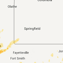
Missouri
| Local Time | Report Details |
|---|---|
| 1:41 AM UTC | Quarter sized hail reported near Tiff City, MO, 78.2 miles WSW of Springfield, MO |
| 1:58 AM UTC | Ping Pong Ball sized hail reported near Goodman, MO, 69.3 miles WSW of Springfield, MO |
| 2:02 AM UTC | Quarter sized hail reported near Anderson, MO, 73.6 miles WSW of Springfield, MO |
Arkansas
| Local Time | Report Details |
|---|---|
| 3:35 AM UTC | Quarter sized hail reported near Midland, AR, 20.7 miles S of Fort Smith, AR |
| 3:45 AM UTC | Large trees across ridge road north of dyer in crawford county AR, 18.4 miles ENE of Fort Smith, AR |
| 3:47 AM UTC | Storm damage reported in sebastian county AR, 22.5 miles SSE of Fort Smith, AR |
| 3:48 AM UTC | Quarter sized hail reported near Huntington, AR, 22.5 miles SSE of Fort Smith, AR |
| 3:54 AM UTC | Multiples trees and powerlines are dow in yell county AR, 58.6 miles ESE of Fort Smith, AR |
| 3:56 AM UTC | Quarter sized hail reported near Hatfield, AR, 48.2 miles NW of Nashville, AR |
| 3:57 AM UTC | Golf Ball sized hail reported near Hatfield, AR, 48.2 miles NW of Nashville, AR |
| 3:58 AM UTC | Golf Ball sized hail reported near Hatfield, AR, 46.8 miles NW of Nashville, AR |
| 4:00 AM UTC | Damage was reported to chicken houses and a large tree was reported down in bogg spring in polk county AR, 41.7 miles NW of Nashville, AR |
| 4:03 AM UTC | Quarter sized hail reported near Mena, AR, 49 miles NNW of Nashville, AR |
| 4:05 AM UTC | A house was severely damaged...with windows blown out...and awning ripped off. ironwork in the houses yard was bent. large and small limbs were blown dow in polk county AR, 49 miles NNW of Nashville, AR |
| 4:05 AM UTC | A house was severely damaged...with windows blown out...and awning ripped off. ironwork in the houses yard was bent. large and small limbs were blown down. the house is in polk county AR, 49 miles NNW of Nashville, AR |
| 4:07 AM UTC | Trees are down on a house and vehicle on the south side of men in polk county AR, 49 miles NNW of Nashville, AR |
| 4:10 AM UTC | Mobile home rolled at highways 22 and 41 in franklin county AR, 27.1 miles E of Fort Smith, AR |
| 4:11 AM UTC | Hen Egg sized hail reported near Mena, AR, 49 miles NNW of Nashville, AR |
| 4:14 AM UTC | About 1 1/2 south of highway 22 and 41 intersection two chicken houses damaged. sheet metal ripped off. a mobile home was damaged...on ucal road...either rolled or a tr in franklin county AR, 27.6 miles ESE of Fort Smith, AR |
| 4:16 AM UTC | Several trees were blown ove in yell county AR, 62.7 miles ESE of Fort Smith, AR |
| 4:16 AM UTC | A frito lay storage warehouse was destroyed. this report was relayed by the medi in polk county AR, 49 miles NNW of Nashville, AR |
| 4:16 AM UTC | Quarter sized hail reported near Danville, AR, 62.7 miles ESE of Fort Smith, AR |
| 4:19 AM UTC | Quarter sized hail reported near Mena, AR, 49 miles NNW of Nashville, AR |
| 4:21 AM UTC | Power lines and power poles are down across the city of mena. a good part of the city is without powe in polk county AR, 49 miles NNW of Nashville, AR |
| 4:44 AM UTC | Telephone poles are down in russellvill in pope county AR, 60.8 miles NW of Little Rock, AR |
| 5:16 AM UTC | A trailer house was blown over and destroyed. numerous trees and powerlines are down. multiple houses have damage to them but the extent of this damage is unknown at th in yell county AR, 61.6 miles ESE of Fort Smith, AR |
| 5:23 AM UTC | Trees are down along highway 27 in montgomery county AR, 55.1 miles NNE of Nashville, AR |
| 5:30 AM UTC | Wind gust estimated between 75 and 80 mp in pope county AR, 60.8 miles NW of Little Rock, AR |
| 5:30 AM UTC | Trees and powerlines are down in russellvill in pope county AR, 60.8 miles NW of Little Rock, AR |
| 5:30 AM UTC | Quarter sized hail reported near Mt Ida, AR, 43.3 miles NNE of Nashville, AR |
| 5:30 AM UTC | Quarter sized hail reported near Batesville, AR, 81.2 miles NNE of Little Rock, AR |
| 5:34 AM UTC | Numerous trees are down across the tow in pope county AR, 56 miles NW of Little Rock, AR |
| 5:48 AM UTC | Quarter sized hail reported near Royal, AR, 47.3 miles NNE of Nashville, AR |
| 5:50 AM UTC | *** 2 fatal *** the top of a tree fell on a mobile home...killing two occupant in garland county AR, 49.3 miles NE of Nashville, AR |
| 5:52 AM UTC | Trees and powerlines are down. some minor structural damage was also reporte in garland county AR, 49.3 miles NE of Nashville, AR |
| 5:55 AM UTC | High winds removed roof off of building in batesville. other parts of the county had some trees blown down but no other property damage at this tim in independence county AR, 79.5 miles NNE of Little Rock, AR |
| 5:58 AM UTC | Storm damage reported in conway county AR, 38.8 miles NW of Little Rock, AR |
| 6:07 AM UTC | Golf Ball sized hail reported near Hot Springs National Park, AR, 47.7 miles WSW of Little Rock, AR |
| 6:12 AM UTC | Trees were reported down on houses on escuadron lane and trees on a gazebo and houses on encantado lane in garland county AR, 41.7 miles W of Little Rock, AR |
| 6:14 AM UTC | Quarter sized hail reported near Hot Springs National Park, AR, 47.7 miles WSW of Little Rock, AR |
| 6:15 AM UTC | Golf Ball sized hail reported near Texarkana, AR, 35.7 miles SSW of Nashville, AR |
| 6:15 AM UTC | Report of a tree fallen on a house with atleast one person trapped insid in garland county AR, 47.7 miles WSW of Little Rock, AR |
| 6:30 AM UTC | Large tree fell down on roof of house in the overview subdiviso in saline county AR, 21.3 miles SW of Little Rock, AR |
| 6:30 AM UTC | A large barn was completely destroyed with debris blown across the fiel in van buren county AR, 47.7 miles N of Little Rock, AR |
| 6:34 AM UTC | Several barns and houses have sustained damage in the glen rose communit in hot spring county AR, 32.7 miles SW of Little Rock, AR |
| 6:34 AM UTC | Trees down across the city and faulkner count in faulkner county AR, 33.7 miles N of Little Rock, AR |
| 6:34 AM UTC | Trees down along hwy 16 in hot spring county AR, 40.6 miles SW of Little Rock, AR |
| 6:35 AM UTC | Quarter sized hail reported near Malvern, AR, 40.6 miles SW of Little Rock, AR |
| 6:35 AM UTC | Golf Ball sized hail reported near Hope, AR, 24.2 miles SE of Nashville, AR |
| 6:38 AM UTC | Quarter sized hail reported near Benton, AR, 27 miles SW of Little Rock, AR, wind gusts of 40 mph and small tree limbs have been reported down as well. |
| 6:41 AM UTC | Quarter sized hail reported near Benton, AR, 26.5 miles SW of Little Rock, AR |
| 6:41 AM UTC | Several trrres have falle in saline county AR, 26.5 miles SW of Little Rock, AR |
| 6:42 AM UTC | Powerlines are down and power is out in parts of malver in hot spring county AR, 40.6 miles SW of Little Rock, AR |
| 6:47 AM UTC | Funnel cloud spotted heading into paron. debris has been reported with trees dow in saline county AR, 27.1 miles W of Little Rock, AR |
| 6:47 AM UTC | Golf Ball sized hail reported near Benton, AR, 18.7 miles WSW of Little Rock, AR |
| 7:00 AM UTC | Damage was reported to empty chicken houses. one roof was blown off along with one barn roof. farris cementery road is blocked by multiple trees downe in stone county AR, 80.8 miles N of Little Rock, AR |
| 7:00 AM UTC | *** 2 fatal *** a large tree fell onto a house...killing two occupants. this is also 6 west of downtown little rock...just northwest of the barrow road exit of intersta in pulaski county AR, 6 miles W of Little Rock, AR |
| 7:00 AM UTC | *** 2 fatal *** a large tree fell onto a house...killing two occupant in pulaski county AR, 3.9 miles WSW of Little Rock, AR |
| 7:02 AM UTC | 10 large trees down...mostly pines and oak in pulaski county AR, 7.8 miles SSW of Little Rock, AR |
| 7:06 AM UTC | Trres and powerline down along i-53 in saline county AR, 13.7 miles S of Little Rock, AR |
| 7:10 AM UTC | A large oak tree fell and damaged a steel concrete walkway. also there was several trees down in the are in pulaski county AR, 3 miles NNE of Little Rock, AR |
| 7:10 AM UTC | Numerous trees have fallen with several trees on houses. gas line ruptures have occured and two houses are on fir in pulaski county AR, 0.8 miles NNE of Little Rock, AR |
| 7:10 AM UTC | *** 1 inj *** a mobile home was destroyed...and the occupant was thrown from it and sustained injurie in pulaski county AR, 11.7 miles SE of Little Rock, AR |
| 7:10 AM UTC | Golf Ball sized hail reported near North Little Rock, AR, 3 miles NNE of Little Rock, AR, located in lakewood village. |
| 7:14 AM UTC | Storm damage reported in pulaski county AR, 6.7 miles NNE of Little Rock, AR |
| 7:14 AM UTC | Eight to ten homes with tree limbs or trees on them with minor damage. mccain blvd has about eight to ten buisnesses without powe in pulaski county AR, 3 miles NNE of Little Rock, AR |
| 7:15 AM UTC | A moblie home was reported off its foundation injuring an occupant. a 250 gallon propane tank was ripped from the foundation. also a tree fell on a residence out on hig in pulaski county AR, 3 miles NNE of Little Rock, AR |
| 7:15 AM UTC | Power poles were snapped in half near the intersection of highway 232 and templeton roa in lonoke county AR, 16.9 miles SE of Little Rock, AR |
| 7:15 AM UTC | Trees down along 530 north of dixon rd. mile marker in pulaski county AR, 6.4 miles SSE of Little Rock, AR |
| 7:15 AM UTC | Trees were blocking river road just off of highway 16 in pulaski county AR, 10.7 miles SE of Little Rock, AR |
| 7:15 AM UTC | *** 1 fatal *** a tree fell on an rv...killing the occupant insid in pulaski county AR, 9.4 miles SE of Little Rock, AR |
| 7:19 AM UTC | Trees down and blocking parts of hwy 161. a trailed has been damaged and fire and resuce is on the scene. there are several trapped occupant in pulaski county AR, 13.8 miles SE of Little Rock, AR |
| 7:19 AM UTC | Trres down and blocking parts of hwy 161. a trailed has been damaged and fire and resuce is on the scene. there are several trapped occupant in pulaski county AR, 13.8 miles SE of Little Rock, AR |
| 7:30 AM UTC | A large number of tree limbs 12 to 24 inches in diameter were downed across the harding university campu in white county AR, 45.8 miles NE of Little Rock, AR |
| 7:31 AM UTC | Storm damage reported in jefferson county AR, 33.8 miles SSE of Little Rock, AR |
| 7:40 AM UTC | *** 1 fatal *** a tree fell on a house...killing an occupan in white county AR, 55.6 miles NE of Little Rock, AR |
| 7:51 AM UTC | Trees were blown down along highway 27 in dallas county AR, 64.5 miles S of Little Rock, AR |
| 8:00 AM UTC | Trees were blown down in riso in cleveland county AR, 55.3 miles S of Little Rock, AR |
| 8:05 AM UTC | Numerous trees and power lines were reported downed by the storms throughout monroe count in monroe county AR, 55 miles E of Little Rock, AR |
| 8:05 AM UTC | Trees were blown dow in calhoun county AR, 66.4 miles NNW of Bastrop, LA |
| 8:10 AM UTC | A waffle house sign blew down in the parking lot near heritage inn in brinkle in monroe county AR, 62.3 miles E of Little Rock, AR |
| 8:10 AM UTC | Trees and power lines were blown down in brinkley. also...large signs of several businesses were blown dow in monroe county AR, 62.3 miles E of Little Rock, AR |
| 8:15 AM UTC | Power lines were blown dow in woodruff county AR, 65.6 miles W of Memphis, TN |
| 8:20 AM UTC | Reports of some trees down across the count in union county AR, 52.9 miles NW of Bastrop, LA |
| 8:45 AM UTC | *** 1 in st. francis county AR, 46.8 miles W of Memphis, TN |
| 8:45 AM UTC | *** 1 in st. francis county AR, 46.8 miles W of Memphis, TN |
| 8:45 AM UTC | *** 1 in st. francis county AR, 46.8 miles W of Memphis, TN |
| 8:48 AM UTC | Severe winds removed a large part of the roofing material from the country hearth hotel along holiday drive in forrest cit in st. francis county AR, 43.1 miles WSW of Memphis, TN |
| 8:48 AM UTC | Severe winds removed the roof from the country hearth hotel along holiday drive in forrest cit in st. francis county AR, 43.1 miles WSW of Memphis, TN |
| 8:50 AM UTC | Quarter sized hail reported near Crossett, AR, 26.5 miles N of Bastrop, LA, quarter hail reported in north crossett by general public. |
| 9:00 AM UTC | Trees were blown dow in drew county AR, 58.5 miles N of Bastrop, LA |
| 9:08 AM UTC | Power lines down u.s. highway 63 and commerce drive in craighead county AR, 56.5 miles NW of Memphis, TN |
| 9:09 AM UTC | Trees down on homes and vehicles. camping trailer overturned in lo in craighead county AR, 55 miles NW of Memphis, TN |
| 9:15 AM UTC | Damaged shed and power lines down in town of lunsford along highway 158 in craighead county AR, 47.1 miles NNW of Memphis, TN |
| 9:18 AM UTC | Power lines down at main and central in craighead county AR, 49.9 miles NW of Memphis, TN |
| 9:20 AM UTC | 1 trailer completely destroyed with minor injuries. 3 trailers suffered minor damage. trees down on cars. power lines down. all in lakeshore communit in crittenden county AR, 9.5 miles WNW of Memphis, TN |
| 9:55 AM UTC | A tree was downed across ar highway 8 in ashley county AR, 29.7 miles NNE of Bastrop, LA |
| 10:00 AM UTC | Several trees downed on black pond road. possible tornado in chicot county AR, 60.1 miles NNE of Bastrop, LA |
| 10:15 AM UTC | Several trees fell in arkansas city with some minor structural damage to a gas statio in desha county AR, 70.4 miles NE of Bastrop, LA |
| 10:15 AM UTC | Trees were downed along ar highway 8 in parkdale in ashley county AR, 31.7 miles NE of Bastrop, LA |
Alabama
| Local Time | Report Details |
|---|---|
| 7:05 AM UTC | A tree fell on a home at 309 east spruce street in jackson a in clarke county AL, 48 miles SW of Camden, AL |
Louisiana
| Local Time | Report Details |
|---|---|
| 7:30 AM UTC | A tree was downed near the hwy 71/hwy 1 split near blanchar in caddo county LA, 8.8 miles NW of Shreveport, LA |
| 7:35 AM UTC | Dispatch reports numerous powerlines and light poles down around the cullen are in webster county LA, 35.8 miles NNE of Shreveport, LA |
| 7:35 AM UTC | Dispatch reports numerous powerlines and light poles down in the cullen are in webster county LA, 35.8 miles NNE of Shreveport, LA |
| 7:55 AM UTC | Trees reported down in the shongaloo area...partially covering roadway in webster county LA, 39.6 miles NE of Shreveport, LA |
| 10:06 AM UTC | Tree reported down near the town of farmervill in union county LA, 28.8 miles W of Bastrop, LA |
| 10:40 AM UTC | Trees were downed in the log cabin area in morehouse county LA, 4.1 miles NNE of Bastrop, LA |
| 11:00 AM UTC | Trees were downed west of oak grove in west carroll county LA, 26.5 miles ENE of Bastrop, LA |
| 11:10 AM UTC | Several trees down in the oak grove area...some blocking roadways in west carroll county LA, 31.1 miles E of Bastrop, LA |
| 11:30 AM UTC | Quarter sized hail reported near Monroe, LA, 20.8 miles SSW of Bastrop, LA |
Tennessee
| Local Time | Report Details |
|---|---|
| 10:00 AM UTC | Multiple topped and downed trees along with large tree limbs falling on and damaging car in dyer county TN, 43.6 miles W of Mc Kenzie, TN |
Mississippi
| Local Time | Report Details |
|---|---|
| 10:00 AM UTC | Straight line thunderstorm winds uprooted numerous large trees and tore away metal roof parts from several outbuildings. a large metal carport awning was picked up and in desoto county MS, 28.4 miles SE of Memphis, TN |
| 10:15 AM UTC | Minor damage to the roof of a shop near the washington/bolivar county border in washington county MS, 71.4 miles NE of Bastrop, LA |
| 11:04 AM UTC | Power poles snapped along county road 531. possible tornad in leflore county MS, 92.8 miles W of Starkville, MS |
| 11:04 AM UTC | Estimated 80mph caused a power pole to lean. a home had half of the shingles torn off and the roof lifted. damage to a shed also occurre in leflore county MS, 93.4 miles W of Starkville, MS |
| 11:10 AM UTC | Estimated 50 to 60 mph winds along us highway 61 betwen hollandale and arcola in washington county MS, 67.9 miles ENE of Bastrop, LA |
| 11:10 AM UTC | Straight line winds estimated at 75mph caused an estimated 500 yard wide swath of sporadic trees snapped and large limbs broken. shingles were taken off an old church o in leflore county MS, 89.2 miles WNW of Starkville, MS |
| 11:13 AM UTC | A roof was blown off a trailer along us highway 49e. multiple trees and power lines downed...and fences were downed in the are in leflore county MS, 87.4 miles WNW of Starkville, MS |
| 11:13 AM UTC | Update...one trailer was destroyed and another lost the roof and skirting. multiple trees and power lines downed...and fences were downed in the are in leflore county MS, 87.4 miles WNW of Starkville, MS |
| 11:25 AM UTC | A roof was blown off a mobile home in issaquena county MS, 53 miles ENE of Bastrop, LA |
| 11:30 AM UTC | Several trees downed across leflore county in washington county MS, 65.5 miles NE of Bastrop, LA |
| 11:30 AM UTC | Several trees downed across leflore county in leflore county MS, 79.6 miles W of Starkville, MS |
| 11:55 AM UTC | Tree debris blown by wind visible at time of the report in yalobusha county MS, 73.5 miles WNW of Starkville, MS |
| 11:55 AM UTC | 5 trees down in the city of grenada...reports also starting to come in from the county in grenada county MS, 61.4 miles WNW of Starkville, MS |
Connect with Interactive Hail Maps