

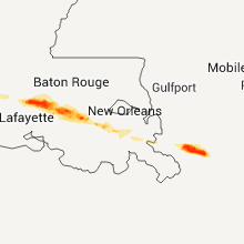
Hail Map for Friday, April 24, 2015

Number of Impacted Households on 4/24/2015
0
Impacted by 1" or Larger Hail
0
Impacted by 1.75" or Larger Hail
0
Impacted by 2.5" or Larger Hail
Square Miles of Populated Area Impacted on 4/24/2015
0
Impacted by 1" or Larger Hail
0
Impacted by 1.75" or Larger Hail
0
Impacted by 2.5" or Larger Hail


Cities Most Affected by Hail Storms of 4/24/2015
| Hail Size | Demographics of Zip Codes Affected | ||||||
|---|---|---|---|---|---|---|---|
| City | Count | Average | Largest | Pop Density | House Value | Income | Age |
| Bronte, TX | 2 | 2.25 | 2.75 | 2 | $44k | $28.2k | 44.9 |
| Russell, KS | 2 | 2.13 | 2.50 | 15 | $46k | $30.2k | 45.3 |
| Lucas, KS | 2 | 2.13 | 2.50 | 2 | $26k | $31.1k | 51.2 |
| Wilson, KS | 2 | 2.13 | 2.50 | 3 | $40k | $37.7k | 49.6 |
| Natoma, KS | 1 | 2.75 | 2.75 | 2 | $19k | $27.0k | 45.6 |
| Breaux Bridge, LA | 1 | 2.75 | 2.75 | 190 | $73k | $31.2k | 35.3 |
| Saint Martinville, LA | 1 | 2.75 | 2.75 | 144 | $65k | $29.5k | 36.6 |
| San Antonio, TX | 1 | 2.00 | 2.00 | 3485 | $87k | $46.3k | 30.3 |
| Cross Plains, TX | 1 | 2.00 | 2.00 | 10 | $34k | $23.0k | 47.8 |
| Vivian, LA | 1 | 1.75 | 1.75 | 64 | $44k | $26.7k | 38.1 |
| Taylor, NE | 1 | 1.75 | 1.75 | 1 | $20k | $26.7k | 46.6 |
| Stephenville, TX | 1 | 1.75 | 1.75 | 61 | $72k | $30.6k | 29.6 |
| Tolar, TX | 1 | 1.75 | 1.75 | 20 | $66k | $42.6k | 40.5 |
| Paradise, KS | 1 | 1.75 | 1.75 | 1 | $36k | $30.8k | 50.0 |
| Jacksonville, TX | 1 | 1.75 | 1.75 | 87 | $52k | $28.3k | 34.8 |
| White Castle, LA | 1 | 1.75 | 1.75 | 38 | $69k | $23.6k | 36.9 |
| Wingate, TX | 1 | 1.75 | 1.75 | 1 | $33k | $27.2k | 54.7 |
| Plainville, KS | 1 | 1.75 | 1.75 | 8 | $43k | $30.7k | 42.6 |
| Ellis, KS | 1 | 1.75 | 1.75 | 8 | $55k | $30.4k | 40.4 |
| Stockton, KS | 1 | 1.75 | 1.75 | 5 | $41k | $31.2k | 46.6 |
| Gorham, KS | 1 | 1.75 | 1.75 | 1 | $40k | $25.0k | 41.7 |
| Mitchell, SD | 1 | 1.75 | 1.75 | 72 | $73k | $33.2k | 37.8 |
| Waxahachie, TX | 1 | 1.75 | 1.75 | 348 | $90k | $48.1k | 33.7 |
| Floresville, TX | 1 | 1.75 | 1.75 | 53 | $82k | $38.4k | 40.3 |
Hail and Wind Damage Spotted on 4/24/2015
Filter by Report Type:Hail ReportsWind Reports
States Impacted
Texas, Louisiana, Oklahoma, Kansas, Nebraska, Oregon, South Dakota, Colorado, Arkansas, MississippiTexas
| Local Time | Report Details |
|---|---|
| 12:05 PM CDT | Tree on top of hous in tyler county TX, 48.9 miles NNW of Beaumont, TX |
| 12:20 PM CDT | Storm damage reported in jasper county TX, 46.2 miles NNW of Beaumont, TX |
| 12:30 PM CDT | Law enforcement reported trees down in call in newton county TX, 36.5 miles NNW of Beaumont, TX |
| 1:10 PM CDT | Measured by the west tx mesonet near northfiel in motley county TX, 24.8 miles WSW of Childress, TX |
| 1:30 PM CDT | Scattered roof damage. some debris on main stree in childress county TX, 2.3 miles WSW of Childress, TX |
| 2:28 PM CDT | Half Dollar sized hail reported near Robert Lee, TX, 64.3 miles SW of Abilene, TX |
| 2:38 PM CDT | Residential roofs damage in coke county TX, 58 miles SW of Abilene, TX |
| 2:57 PM CDT | Golf Ball sized hail reported near Bronte, TX, 48 miles SW of Abilene, TX |
| 3:08 PM CDT | Quarter sized hail reported near Wingate, TX, 35.5 miles SW of Abilene, TX |
| 3:09 PM CDT | Golf Ball sized hail reported near Wingate, TX, 43.8 miles SW of Abilene, TX, hail busted numerous vehicle windows. |
| 3:15 PM CDT | Storm damage reported in coke county TX, 57.8 miles SW of Abilene, TX |
| 3:15 PM CDT | Baseball sized hail reported near Bronte, TX, 57.8 miles SW of Abilene, TX |
| 3:22 PM CDT | Storm damage reported in runnels county TX, 34.8 miles SSW of Abilene, TX |
| 3:50 PM CDT | 4 trees down...21 inches in diameter at fm 382 and fm 264 in runnels county TX, 46.4 miles SSW of Abilene, TX |
| 4:05 PM CDT | Storm damage reported in tom green county TX, 87.3 miles SSW of Abilene, TX |
| 4:05 PM CDT | A car port was blown 100 feet and severly damaged. also... large tree branches were blown down and a slide was damaged. a possible tornad in coleman county TX, 30.9 miles SSE of Abilene, TX |
| 4:06 PM CDT | Storm damage reported in tom green county TX, 87.3 miles SSW of Abilene, TX |
| 4:18 PM CDT | Quarter sized hail reported near Miles, TX, 63.9 miles SSW of Abilene, TX |
| 4:23 PM CDT | Quarter sized hail reported near Burkett, TX, 43.5 miles SE of Abilene, TX |
| 4:30 PM CDT | Numerous trees down across the city. some trees down on car in callahan county TX, 40 miles ESE of Abilene, TX |
| 4:34 PM CDT | Quarter sized hail reported near Rowena, TX, 63.8 miles SSW of Abilene, TX |
| 4:38 PM CDT | Hen Egg sized hail reported near Cross Plains, TX, 40 miles ESE of Abilene, TX |
| 4:47 PM CDT | Storm damage reported in concho county TX, 65.7 miles S of Abilene, TX |
| 5:08 PM CDT | Trees down mary st and and shady creek in madison county TX, 75.6 miles WSW of Lufkin, TX |
| 5:10 PM CDT | 70-80 mph winds blew down trees in comanche county TX, 73.3 miles ESE of Abilene, TX |
| 5:30 PM CDT | Storm damage reported in erath county TX, 81.6 miles NNW of Killeen, TX |
| 5:34 PM CDT | Golf Ball sized hail reported near Stephenville, TX, 81.6 miles NNW of Killeen, TX |
| 5:38 PM CDT | Golf Ball sized hail reported near Tolar, TX, 69.5 miles WSW of Dallas, TX, relayed from the tolar fire department |
| 5:54 PM CDT | 2 feet diameter tree uprooted in hood county TX, 60.7 miles WSW of Dallas, TX |
| 5:58 PM CDT | 1.5" diameter trees uprooted in somervell county TX, 68.8 miles WSW of Dallas, TX |
| 6:00 PM CDT | Storm damage reported in somervell county TX, 67.3 miles SW of Dallas, TX |
| 6:06 PM CDT | 65 to 70 mph at comanche peak in somervell county TX, 67.3 miles SW of Dallas, TX |
| 6:12 PM CDT | Building damage in johnson county TX, 48.4 miles WSW of Dallas, TX |
| 6:14 PM CDT | Quarter sized hail reported near Cresson, TX, 51.6 miles WSW of Dallas, TX |
| 6:14 PM CDT | Hwy377 and tiger trail in tarrant county TX, 42.9 miles WSW of Dallas, TX |
| 6:15 PM CDT | Tcu area in tarrant county TX, 31.8 miles W of Dallas, TX |
| 6:22 PM CDT | 70-80 mph wind in johnson county TX, 40.2 miles WSW of Dallas, TX |
| 6:29 PM CDT | Tree down in street... large limbs down throughout area in tarrant county TX, 31.8 miles W of Dallas, TX |
| 6:42 PM CDT | Quarter sized hail reported near Venus, TX, 30.6 miles SW of Dallas, TX, us67 ad fm157 |
| 6:45 PM CDT | Wide spread tree damage... damage to car ports as well in johnson county TX, 40.2 miles WSW of Dallas, TX |
| 6:46 PM CDT | Near new york and arbrook in tarrant county TX, 19.2 miles W of Dallas, TX |
| 6:46 PM CDT | Residential roof damage and trees branches downed near new york and arbrook in tarrant county TX, 19.2 miles W of Dallas, TX |
| 6:50 PM CDT | Quarter sized hail reported near Eagle Pass, TX, 41 miles SSE of Del Rio, TX, nickel to quarter size hail reported by border patrol. |
| 6:55 PM CDT | Trees uprooted in tarrant county TX, 35.2 miles W of Dallas, TX |
| 7:04 PM CDT | Golf Ball sized hail reported near Waxahachie, TX, 26.3 miles S of Dallas, TX |
| 7:05 PM CDT | Ping Pong Ball sized hail reported near Waxahachie, TX, 21.5 miles S of Dallas, TX |
| 8:22 PM CDT | Quarter sized hail reported near , , 48.6 miles NNE of Laredo, TX |
| 8:25 PM CDT | Winds estimated by storm spotte in camp county TX, 83.5 miles WNW of Shreveport, LA |
| 8:40 PM CDT | Trees down in white oak in gregg county TX, 65 miles W of Shreveport, LA |
| 8:40 PM CDT | Numerous trees down across the county area in upshur county TX, 71.7 miles WNW of Shreveport, LA |
| 8:58 PM CDT | Damage to union hill high school and several homes in the neighborhoo in upshur county TX, 74.7 miles WNW of Shreveport, LA |
| 9:06 PM CDT | Quarter sized hail reported near Dawson, TX, 62 miles S of Dallas, TX |
| 9:09 PM CDT | Storm damage reported in upshur county TX, 68 miles W of Shreveport, LA |
| 9:10 PM CDT | Forty foot crepe myrtle lost the top half of the tre in cass county TX, 61.8 miles WNW of Shreveport, LA |
| 9:10 PM CDT | Quarter sized hail reported near Pearsall, TX, 51.5 miles SW of San Antonio, TX, nickel to quarter size hail |
| 9:14 PM CDT | Numerous trees down across the county area in upshur county TX, 71.7 miles WNW of Shreveport, LA |
| 9:15 PM CDT | Numerous trees down across the county area in upshur county TX, 71.7 miles WNW of Shreveport, LA |
| 9:31 PM CDT | Tree on house in town in marion county TX, 39 miles WNW of Shreveport, LA |
| 9:40 PM CDT | A few trees down...power lines down in harrison county TX, 36.8 miles WNW of Shreveport, LA |
| 10:23 PM CDT | Large tree down across hwy 175 in cherokee county TX, 54.8 miles NW of Lufkin, TX |
| 10:39 PM CDT | Golf Ball sized hail reported near Jacksonville, TX, 52.1 miles NNW of Lufkin, TX, relayed through media. |
| 10:40 PM CDT | A few trees down...power lines down in harrison county TX, 36.8 miles WNW of Shreveport, LA |
| 10:40 PM CDT | Numerous trees down in rusk county TX, 56.5 miles N of Lufkin, TX |
| 11:00 PM CDT | Emergency manager of weslaco reported several trees down in the pleasantview area near weslac in hidalgo county TX, 33.3 miles WNW of Brownsville, TX |
| 11:00 PM CDT | Donna police department reports mobile home flipped over on ponciano drive just north of donn in hidalgo county TX, 39.2 miles WNW of Brownsville, TX |
| 11:00 PM CDT | Hidalgo county so reports wire fence blown down on mirasol road in donn in hidalgo county TX, 39.2 miles WNW of Brownsville, TX |
| 11:00 PM CDT | Public reported backyard metal pergola destroyed on the southwest side of weslaco. time estimated from rada in hidalgo county TX, 35.8 miles WNW of Brownsville, TX |
| 11:00 PM CDT | Hidalgo county so reports mobile home damage at the tower road and owassa road intersection in edinbur in hidalgo county TX, 49.7 miles NW of Brownsville, TX |
| 11:00 PM CDT | Hidalgo county so reports aluminum fence blown over on owassa road in edinbur in hidalgo county TX, 49.7 miles NW of Brownsville, TX |
| 11:20 PM CDT | La feria police department reports tree blown down onto parker road in la feri in cameron county TX, 27 miles NW of Brownsville, TX |
| 11:20 PM CDT | Public reported backyard metal pergola destroyed on the southwest side of weslaco. time estimated from rada in hidalgo county TX, 35.8 miles WNW of Brownsville, TX |
| 11:20 PM CDT | Emergency manager of weslaco reported several trees down in the pleasantview area near weslaco. time estimated from rada in hidalgo county TX, 33.3 miles WNW of Brownsville, TX |
| 11:25 PM CDT | Report of road signs blown out of the ground along us 83 near weslac in hidalgo county TX, 33.5 miles WNW of Brownsville, TX |
| 11:30 PM CDT | Cameron county so reports tree blown down onto hand road in combe in cameron county TX, 27.3 miles NNW of Brownsville, TX |
| 11:30 PM CDT | Cameron county so reports 2 trees down on fm 506 south of clark road in la feri in cameron county TX, 27 miles NW of Brownsville, TX |
| 11:30 PM CDT | Cameron county so reports utility wires blown down into the road in primer in cameron county TX, 28.1 miles NW of Brownsville, TX |
| 11:30 PM CDT | Harlingen police department reports two medium-sized trees blown down onto garrett road in harlinge in cameron county TX, 24 miles NNW of Brownsville, TX |
| 11:30 PM CDT | San benito police department reports 1 tree blown down onto south sam houston. also trampoline blown into side of house that caused windows to break on san jacinto driv in cameron county TX, 18.8 miles NNW of Brownsville, TX |
| 11:30 PM CDT | Several powerlines down in the city of edcouch. time estimated from rada in hidalgo county TX, 39.4 miles NW of Brownsville, TX |
| 11:30 PM CDT | Mercedes police department reports 10 to 12 power lines and 15 to 20 trees down across the city of mercede in hidalgo county TX, 31.5 miles WNW of Brownsville, TX |
| 11:32 PM CDT | Trained spotter reported 63 kt wind gusts at intersection of 88tx and 1 1/2 mil in hidalgo county TX, 35.1 miles WNW of Brownsville, TX |
| 11:35 PM CDT | Harlingen asos at valley international airport reported a 58 mph measured wind gus in cameron county TX, 24.7 miles NNW of Brownsville, TX |
| 11:35 PM CDT | Public reported a measured 60 mph wind gust with a davis instrument in harlinge in cameron county TX, 24 miles NNW of Brownsville, TX |
| 11:35 PM CDT | Public reported medium size tree down on a car in primera via social medi in cameron county TX, 28.1 miles NW of Brownsville, TX |
| 11:37 PM CDT | Quarter sized hail reported near San Benito, TX, 18.9 miles WNW of Brownsville, TX, trained skywarn spotter in los indios reported quarter-size hail. |
| 3:15 AM CDT | At texas research park. small tree limbs down less than 2 inches. 1.00-1.25 inches of rain in 1 hou in bexar county TX, 18.4 miles W of San Antonio, TX |
| 3:30 AM CDT | Hen Egg sized hail reported near San Antonio, TX, 11.8 miles W of San Antonio, TX, tree limbs greater than 2 inches down in addition to hail. |
| 3:54 AM CDT | Trees down... 4-5 trailers flipped at hwy 90 and 173... doors blown out of ford dealership in medina county TX, 40.4 miles W of San Antonio, TX |
| 3:55 AM CDT | Half Dollar sized hail reported near San Antonio, TX, 10.1 miles WNW of San Antonio, TX |
| 4:15 AM CDT | Quarter sized hail reported near San Antonio, TX, 7.4 miles WNW of San Antonio, TX, near i-410 and bandera in san antonio. |
| 4:20 AM CDT | Quarter sized hail reported near San Antonio, TX, 9.2 miles NNW of San Antonio, TX, at i-10 and fredericksburg rd in san antonio. |
| 4:45 AM CDT | Several trees knocked down by thunderstorm winds. relayed by ksa in medina county TX, 19 miles W of San Antonio, TX |
| 4:47 AM CDT | Ping Pong Ball sized hail reported near Poteet, TX, 25.5 miles SSW of San Antonio, TX |
| 4:49 AM CDT | Quarter sized hail reported near San Antonio, TX, 13.6 miles W of San Antonio, TX |
| 4:55 AM CDT | Half Dollar sized hail reported near Devine, TX, 30.9 miles SW of San Antonio, TX |
| 5:00 AM CDT | Barn door blown in with e60 mph winds in guadalupe county TX, 35.2 miles ENE of San Antonio, TX |
| 5:20 AM CDT | Golf Ball sized hail reported near Floresville, TX, 24.6 miles SE of San Antonio, TX |
| 5:25 AM CDT | Quarter sized hail reported near Floresville, TX, 28.1 miles SE of San Antonio, TX |
Louisiana
| Local Time | Report Details |
|---|---|
| 12:45 PM CDT | Quarter sized hail reported near Singer, LA, 43 miles NNE of Beaumont, TX, media relayed report of estimated quarter sized hail in singer |
| 12:56 PM CDT | Emergency manager reports trees down between fields and ragley. time estimated from rada in beauregard county LA, 36.5 miles NE of Beaumont, TX |
| 1:00 PM CDT | Nws employee reports trees and power lines down along clark rd off of hwy 12. time estimated from rada in beauregard county LA, 38.2 miles NE of Beaumont, TX |
| 1:00 PM CDT | Public shared photo of several large branches down on hwy 110 between singer and longville. time estimated from rada in beauregard county LA, 44.5 miles NE of Beaumont, TX |
| 1:09 PM CDT | Photos of a power pole snapped on 171. time estimated from rada in beauregard county LA, 42.2 miles NE of Beaumont, TX |
| 1:20 PM CDT | Media shared photo of downed tree in reeves. time estimated from rada in allen county LA, 51 miles NE of Beaumont, TX |
| 3:15 PM CDT | Quarter sized hail reported near Breaux Bridge, LA, 8.1 miles ENE of Lafayette, LA, video of quarter sized hail in breaux bridge |
| 3:25 PM CDT | Trained spotter reports estimated 65 mph wind gusts and half dollar size hail in st. martin county LA, 7.7 miles NE of Lafayette, LA |
| 3:30 PM CDT | State police reports two overturned 18 wheelers on interstate 10 near milepost 108 in st. martin county LA, 6.2 miles NE of Lafayette, LA |
| 3:37 PM CDT | Baseball sized hail reported near Breaux Bridge, LA, 8.1 miles ENE of Lafayette, LA, public posted photo of baseball sized hail in breaux bridge and parks area |
| 3:40 PM CDT | Baseball sized hail reported near Saint Martinville, LA, 18.4 miles E of Lafayette, LA, several public photos of tennis ball to baseball sized hail in catahoula |
| 4:25 PM CDT | Golf Ball sized hail reported near White Castle, LA, 52.1 miles E of Lafayette, LA, also wind gusts 50 mph. damage to autos. |
| 4:25 PM CDT | Trees down in bayou pigeon and bayou sorrel. trailer overturned in bayou pigeon are in iberville county LA, 40.7 miles E of Lafayette, LA |
| 6:15 PM CDT | Trees and powerlines down in paradis and lulin in st. charles county LA, 19.7 miles W of New Orleans, LA |
| 9:50 PM CDT | Golf Ball sized hail reported near Vivian, LA, 28.3 miles NNW of Shreveport, LA, busted out 3 windows of a house |
| 9:55 PM CDT | Power lines down in bossier county LA, 25.4 miles N of Shreveport, LA |
| 10:03 PM CDT | Tree down on power line in bossier county LA, 27.3 miles N of Shreveport, LA |
| 10:30 PM CDT | Power lines down...nickel size hail covering the ground in webster county LA, 39.6 miles NE of Shreveport, LA |
| 10:32 PM CDT | Trees down in caddo county LA, 16.8 miles NW of Shreveport, LA |
| 11:10 PM CDT | Trees down... snapped and uprooted in union county LA, 43.5 miles W of Bastrop, LA |
| 11:52 PM CDT | Several trees downed across morehouse parish in morehouse county LA, 0.6 miles SSE of Bastrop, LA |
| 12:18 AM CDT | Trees and utility poles downed around west carroll parish in west carroll county LA, 31.1 miles E of Bastrop, LA |
| 12:20 AM CDT | Tree downed across la hwy 17 in west carroll county LA, 27.9 miles ESE of Bastrop, LA |
| 12:35 AM CDT | Downed utility lines and snapped utility poles in east carroll parish in east carroll county LA, 42.8 miles E of Bastrop, LA |
Oklahoma
| Local Time | Report Details |
|---|---|
| 1:40 PM CDT | 2 inch tree limbs dow in harmon county OK, 37.8 miles NNE of Childress, TX |
| 6:58 PM CDT | Quarter sized hail reported near Calera, OK, 35.9 miles SSW of Atoka, OK |
Kansas
| Local Time | Report Details |
|---|---|
| 4:00 PM CDT | Golf Ball sized hail reported near Ellis, KS, 9.7 miles NW of Hays, KS |
| 4:37 PM CDT | Half Dollar sized hail reported near Plainville, KS, 25.3 miles NNW of Hays, KS, trained spotter reports penny to dime size hail with a few to the size of a half dollar. |
| 4:46 PM CDT | Golf Ball sized hail reported near Plainville, KS, 28.8 miles NNW of Hays, KS |
| 5:04 PM CDT | Golf Ball sized hail reported near Gorham, KS, 15 miles NE of Hays, KS |
| 5:10 PM CDT | Golf Ball sized hail reported near Stockton, KS, 37.7 miles NNW of Hays, KS |
| 5:13 PM CDT | Baseball sized hail reported near Natoma, KS, 19.3 miles NE of Hays, KS |
| 5:20 PM CDT | Quarter sized hail reported near Stockton, KS, 37 miles N of Hays, KS, nws observer reports mostly nickle size hail with some up to the size of quarters. |
| 5:32 PM CDT | Golf Ball sized hail reported near Paradise, KS, 26 miles NE of Hays, KS |
| 5:37 PM CDT | 1 foot diameter tree debris down near 179th and decker road with winds of 70 to 80 mph in russell county KS, 26 miles NE of Hays, KS |
| 5:40 PM CDT | Golf Ball sized hail reported near Russell, KS, 26.7 miles ENE of Hays, KS |
| 5:40 PM CDT | Tennis Ball sized hail reported near Russell, KS, 27.5 miles ENE of Hays, KS |
| 5:46 PM CDT | Storm damage reported in russell county KS, 26.7 miles ENE of Hays, KS |
| 5:50 PM CDT | Quarter sized hail reported near Waldo, KS, 33.8 miles ENE of Hays, KS, mostly nickel size hail with some quarter size |
| 6:33 PM CDT | Quarter sized hail reported near Collyer, KS, 41.2 miles W of Hays, KS |
| 6:34 PM CDT | Ping Pong Ball sized hail reported near Lucas, KS, 44.6 miles ENE of Hays, KS |
| 6:40 PM CDT | Ping Pong Ball sized hail reported near Lucas, KS, 44.6 miles ENE of Hays, KS, emergency manager reports that virtually every car and roof sustained significant hail damage in the town of lucas. all skylights in the middle school were broke out. |
| 6:40 PM CDT | Tennis Ball sized hail reported near Lucas, KS, 44.6 miles ENE of Hays, KS |
| 6:45 PM CDT | Golf Ball sized hail reported near Lucas, KS, 47.4 miles ENE of Hays, KS |
| 6:55 PM CDT | Quarter sized hail reported near Wakeeney, KS, 37.8 miles W of Hays, KS |
| 7:15 PM CDT | Quarter sized hail reported near Lucas, KS, 42.4 miles E of Hays, KS, east side of the lake. also 35 mph winds. |
| 7:15 PM CDT | Tennis Ball sized hail reported near Wilson, KS, 46.5 miles E of Hays, KS, correction to previous report |
| 7:15 PM CDT | Golf Ball sized hail reported near Wilson, KS, 46.5 miles E of Hays, KS |
| 7:25 PM CDT | Quarter sized hail reported near Utica, KS, 39.9 miles W of Hays, KS |
| 7:55 PM CDT | Along i-70 near mile marker 219. via kwch t in ellsworth county KS, 59.6 miles E of Hays, KS |
| 8:54 PM CDT | Quarter sized hail reported near Ludell, KS, 39.5 miles N of Colby, KS, dime to quarter size hail. |
| 10:54 PM CDT | Quarter sized hail reported near Oberlin, KS, 40.1 miles NE of Colby, KS |
Nebraska
| Local Time | Report Details |
|---|---|
| 4:04 PM CDT | Quarter sized hail reported near Burwell, NE, 53.3 miles SW of Oneill, NE, 3 to 4 inches of small hail accumulated on united states highway 183 north of taylor.snow plows were deployed to clear the highway. a couple of hailstones reached 1 inc |
| 6:40 PM CDT | Golf Ball sized hail reported near Taylor, NE, 63.4 miles SW of Oneill, NE, trained spotter reported golf ball sized hail... with the majority of the hail being quarters and dimes. hail covered the ground. |
| 7:30 PM CDT | Quarter sized hail reported near Anselmo, NE, 69.1 miles NE of North Platte, NE, hail has completely covered the ground |
Oregon
| Local Time | Report Details |
|---|---|
| 2:45 PM PDT | Strong wind from shower knocked down a tree in boring... or. time corrected based on follow-up information from the source of the repor in clackamas county OR, 15.5 miles ESE of Portland, OR |
| 3:40 PM PDT | Strong wind from shower knocked down a tree in boring... o in clackamas county OR, 15.5 miles ESE of Portland, OR |
South Dakota
| Local Time | Report Details |
|---|---|
| 5:33 PM CDT | Quarter sized hail reported near Mitchell, SD, 69.3 miles W of Sioux Falls, SD, hail covering the ground. |
| 5:44 PM CDT | Quarter sized hail reported near Mitchell, SD, 70.5 miles WNW of Sioux Falls, SD |
| 5:45 PM CDT | Golf Ball sized hail reported near Mitchell, SD, 71.3 miles W of Sioux Falls, SD |
| 5:53 PM CDT | Quarter sized hail reported near Corsica, SD, 67.5 miles N of Oneill, NE |
| 5:53 PM CDT | Quarter sized hail reported near Corsica, SD, 69.7 miles NNE of Oneill, NE |
| 6:32 PM CDT | Quarter sized hail reported near Corsica, SD, 67.5 miles N of Oneill, NE, hail covering the ground. |
Colorado
| Local Time | Report Details |
|---|---|
| 5:00 PM MDT | Quarter sized hail reported near Elizabeth, CO, 34.3 miles SE of Denver, CO |
Arkansas
| Local Time | Report Details |
|---|---|
| 8:05 PM CDT | Power lines down...trees down in nevada county AR, 37.8 miles ESE of Nashville, AR |
| 10:00 PM CDT | Large tree down blocking the highway 1 mile south of sulphur river on hwy 71 south in miller county AR, 47.3 miles N of Shreveport, LA |
| 10:06 PM CDT | Quarter sized hail reported near Bradley, AR, 40.8 miles N of Shreveport, LA |
| 10:12 PM CDT | Tree down. car ran into it and people trapped. fire dept on scen in lafayette county AR, 41.6 miles NNE of Shreveport, LA |
| 10:30 PM CDT | Trees down on sau campus in columbia county AR, 58.4 miles SE of Nashville, AR |
| 10:30 PM CDT | Power outages at county road 10 and county road 40 in miller county AR, 47.5 miles S of Nashville, AR |
| 11:00 PM CDT | Power lines down in union county AR, 50.4 miles WNW of Bastrop, LA |
| 11:10 PM CDT | Power lines down in union county AR, 52 miles NW of Bastrop, LA |
Mississippi
| Local Time | Report Details |
|---|---|
| 12:30 AM CDT | Tree downed along ms hwy 8 near the grenada tallahatchie county lin in grenada county MS, 78.8 miles WNW of Starkville, MS |
| 12:48 AM CDT | Measured on roof of stationary storm chase vehicle in sharkey county MS, 53.8 miles NW of Jackson, MS |
| 1:15 AM CDT | Several trees downed in yazoo county MS, 33.1 miles NW of Jackson, MS |
| 1:30 AM CDT | Siding damage to a home and a gutter torn off a shop buildin in yazoo county MS, 26.6 miles NNW of Jackson, MS |
| 1:47 AM CDT | Observed by private weather station near gluckstadt in madison county MS, 16.3 miles NNE of Jackson, MS |
| 1:50 AM CDT | Trees uprooted in madison county MS, 22.5 miles NNE of Jackson, MS |
| 1:50 AM CDT | A tree fell on a home on w academy st in madison county MS, 23 miles NNE of Jackson, MS |
| 1:52 AM CDT | Several shingles blown off a home on the east city of canton in madison county MS, 23.9 miles NNE of Jackson, MS |
| 1:58 AM CDT | Tree downed across the natchez trace near milepost 173 in attala county MS, 41.4 miles WSW of Starkville, MS |
| 2:17 AM CDT | Debris in road on ms hwy 25 at ms hwy 13. possible tornado in leake county MS, 39.7 miles NE of Jackson, MS |
| 2:18 AM CDT | Fallen tree crushed camper and car. wind speed estimated around 60 mp in scott county MS, 33.2 miles NE of Jackson, MS |
| 2:25 AM CDT | Numerous trees down across highway 35 just north of walnut grove in leake county MS, 46.9 miles ENE of Jackson, MS |
| 2:25 AM CDT | Scattered trees down across northern scott county in scott county MS, 49.3 miles ENE of Jackson, MS |
| 2:28 AM CDT | Tree downed across ms hwy 35 near twin city in leake county MS, 47.5 miles NE of Jackson, MS |
| 2:30 AM CDT | Trees downed along ms hwy 488. possible tornad in leake county MS, 48.9 miles NE of Jackson, MS |
| 2:46 AM CDT | Trees downed across ms hwy 485 near co rd 361...causing a multivehicle accident in neshoba county MS, 57.1 miles SSW of Starkville, MS |
| 2:47 AM CDT | Trees and powerlines down at a few locations in union in newton county MS, 64.3 miles SSW of Starkville, MS |
| 2:49 AM CDT | Trees downed along ms hwy 15 in neshoba county MS, 59.3 miles SSW of Starkville, MS |
| 2:50 AM CDT | Trees downed along co rd 347 near co rd 444 in neshoba county MS, 56.2 miles SSW of Starkville, MS |
| 2:54 AM CDT | Shed was destroyed...another shed had tin blown off...tin blown off a chicken house...power lines downed along co rd 525 near co rd 448 in neshoba county MS, 55.9 miles SSW of Starkville, MS |
| 2:54 AM CDT | Trees downed across the road along co rd 448 between co rd 525 and ms hwy 19 in neshoba county MS, 55.9 miles SSW of Starkville, MS |
| 3:10 AM CDT | Tree down on highway 495 in kemper county MS, 59 miles S of Starkville, MS |
| 3:15 AM CDT | Scattered power lines down in kemper county MS, 54.9 miles S of Starkville, MS |
Connect with Interactive Hail Maps