

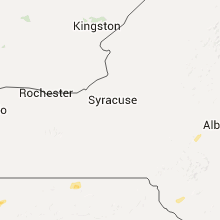
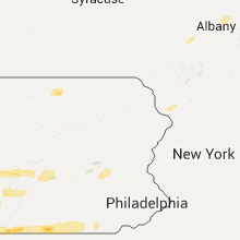
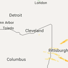
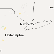
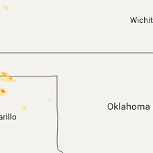
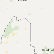
Hail Map for Monday, August 3, 2015

Number of Impacted Households on 8/3/2015
0
Impacted by 1" or Larger Hail
0
Impacted by 1.75" or Larger Hail
0
Impacted by 2.5" or Larger Hail
Square Miles of Populated Area Impacted on 8/3/2015
0
Impacted by 1" or Larger Hail
0
Impacted by 1.75" or Larger Hail
0
Impacted by 2.5" or Larger Hail


Cities Most Affected by Hail Storms of 8/3/2015
| Hail Size | Demographics of Zip Codes Affected | ||||||
|---|---|---|---|---|---|---|---|
| City | Count | Average | Largest | Pop Density | House Value | Income | Age |
| Parker, PA | 4 | 2.19 | 2.50 | 33 | $60k | $31.4k | 43.1 |
| Cincinnati, OH | 3 | 1.83 | 2.00 | 1400 | $128k | $50.6k | 40.4 |
| Liberty, IN | 2 | 1.88 | 2.00 | 48 | $83k | $36.8k | 40.3 |
| Connersville, IN | 1 | 2.50 | 2.50 | 126 | $79k | $38.6k | 40.7 |
| Clarion, PA | 1 | 1.75 | 1.75 | 158 | $90k | $24.5k | 23.1 |
| Mount Sinai, NY | 1 | 1.75 | 1.75 | 1972 | $223k | $85.2k | 42.0 |
| Williamstown, KY | 1 | 1.75 | 1.75 | 72 | $86k | $34.4k | 37.3 |
| Latonia, KY | 1 | 1.75 | 1.75 | 840 | $83k | $40.0k | 38.5 |
| Selma, IN | 1 | 1.75 | 1.75 | 77 | $83k | $51.9k | 42.9 |
| Belle Vernon, PA | 1 | 1.75 | 1.75 | 487 | $83k | $33.9k | 45.8 |
| Sigel, PA | 1 | 1.75 | 1.75 | 9 | $61k | $34.8k | 50.0 |
Hail and Wind Damage Spotted on 8/3/2015
Filter by Report Type:Hail ReportsWind Reports
States Impacted
Pennsylvania, Missouri, Vermont, New York, Indiana, Maine, Ohio, Florida, New Hampshire, Kentucky, Colorado, Texas, West Virginia, Maryland, Virginia, Connecticut, Rhode Island, MassachusettsPennsylvania
| Local Time | Report Details |
|---|---|
| 9:40 AM EDT | Hen Egg sized hail reported near Parker, PA, 53 miles NNE of Pittsburgh, PA |
| 9:40 AM EDT | Tennis Ball sized hail reported near Parker, PA, 53 miles NNE of Pittsburgh, PA, measured 2.5 inch diameter hailstone in callensburg |
| 5:41 PM EDT | Cecil township. trees down. reissing rd in area of state route 50. coleman rd near sowinsky r in washington county PA, 13.9 miles SW of Pittsburgh, PA |
| 5:56 PM EDT | Multiple trees and wires down. 500 block sugar camp rd. 900 block mcclelland r in washington county PA, 11.8 miles SSW of Pittsburgh, PA |
| 6:03 PM EDT | Quarter sized hail reported near South Park, PA, 10.3 miles S of Pittsburgh, PA |
| 6:06 PM EDT | Union township - multiple trees and wires down. 6100 block of state route 88. 500 block of trax rd. brownsville rd ext near chevy chase st. 60 block of gilmore r in washington county PA, 13 miles S of Pittsburgh, PA |
| 6:11 PM EDT | Donegal twp - multiple trees and wires down. 170 block crane rd. state route 231 in area of buck run rd. 50 block buck run r in washington county PA, 30.3 miles SW of Pittsburgh, PA |
| 6:12 PM EDT | Trees down with small hail in washington county PA, 27.4 miles SW of Pittsburgh, PA |
| 6:12 PM EDT | Tree uprooted and several trees snapped. confirmed from photo on twitter in washington county PA, 27.9 miles SW of Pittsburgh, PA |
| 6:16 PM EDT | Buffalo township. multiple trees and wires down. 30 block east buffalo church rd. 80 block east buffalo church rd. 100 block east buffalo church rd. 2800 block sbridge in washington county PA, 28.1 miles SW of Pittsburgh, PA |
| 6:20 PM EDT | Half Dollar sized hail reported near Monongahela, PA, 14.8 miles SSE of Pittsburgh, PA, quarter to half dollar sized haiil and tree limbs down |
| 6:21 PM EDT | Golf Ball sized hail reported near Belle Vernon, PA, 18.6 miles SSE of Pittsburgh, PA |
| 6:23 PM EDT | South franklin twp - multiple trees and wires down. 400 block alamae lakes rd. 500 block lagona rd. 200 block moore r in washington county PA, 27.1 miles SSW of Pittsburgh, PA |
| 6:24 PM EDT | Multiple trees down. time estimated by radar in westmoreland county PA, 19.5 miles SE of Pittsburgh, PA |
| 6:29 PM EDT | Half Dollar sized hail reported near West Newton, PA, 19.8 miles SE of Pittsburgh, PA, quarter then fifty cent sized hail |
| 6:31 PM EDT | Amwell twp - multiple trees and wires down. 1200 block banetown rd. 1275 lagonda rd. lagonda rd / scenic dr. 200 block vankirk ridge r in washington county PA, 26.5 miles SSW of Pittsburgh, PA |
| 6:45 PM EDT | Quarter sized hail reported near Tarrs, PA, 28 miles SE of Pittsburgh, PA, dime to quarter size hail |
| 6:45 PM EDT | Quarter sized hail reported near Scenery Hill, PA, 26.2 miles S of Pittsburgh, PA, quarter sized hail |
| 6:45 PM EDT | Quarter sized hail reported near Export, PA, 21.1 miles E of Pittsburgh, PA, dime to quarter size hail |
| 6:57 PM EDT | Quarter sized hail reported near Mount Pleasant, PA, 31.3 miles SE of Pittsburgh, PA, quarter sized hail |
| 7:03 PM EDT | Quarter sized hail reported near Connellsville, PA, 34.5 miles SE of Pittsburgh, PA |
| 7:12 PM EDT | Quarter sized hail reported near Acme, PA, 38.5 miles SE of Pittsburgh, PA |
| 7:12 PM EDT | Golf Ball sized hail reported near Sigel, PA, 72.2 miles WNW of State College, PA, time estimated by radar |
| 7:45 PM EDT | Trees down along long level rd in elk county PA, 66.9 miles NW of State College, PA |
| 8:00 PM EDT | Quarter sized hail reported near Mc Kees Rocks, PA, 7.8 miles WNW of Pittsburgh, PA |
| 8:00 PM EDT | Quarter sized hail reported near Oakdale, PA, 12.4 miles W of Pittsburgh, PA |
| 8:10 PM EDT | Quarter sized hail reported near Rochester, PA, 23.4 miles NW of Pittsburgh, PA, quarter sized hail |
| 8:12 PM EDT | Many trees down in allegheny county PA, 8 miles WSW of Pittsburgh, PA |
| 8:15 PM EDT | Quarter sized hail reported near Carnegie, PA, 5.3 miles WSW of Pittsburgh, PA |
| 8:15 PM EDT | Quarter sized hail reported near Pittsburgh, PA, 3.5 miles WSW of Pittsburgh, PA, pea...then dime...nickel...quarter sized hail |
| 8:17 PM EDT | Quarter sized hail reported near Pittsburgh, PA, 0.9 miles SW of Pittsburgh, PA, dime to quarter sized hail |
| 8:18 PM EDT | Quarter sized hail reported near Pittsburgh, PA, 4 miles SW of Pittsburgh, PA, quarter sized hail |
| 8:25 PM EDT | Quarter sized hail reported near Pittsburgh, PA, 4.9 miles SSW of Pittsburgh, PA, quarter sized hail |
| 8:36 PM EDT | Quarter sized hail reported near Mars, PA, 18.1 miles N of Pittsburgh, PA, some peas...some nickels...some quarters |
| 9:03 PM EDT | 1 tree down on chambersville road in indiana county PA, 47.9 miles ENE of Pittsburgh, PA |
| 9:10 PM EDT | Ping Pong Ball sized hail reported near Petrolia, PA, 41.1 miles NNE of Pittsburgh, PA, golf ball sized hail |
| 9:29 PM EDT | Quarter sized hail reported near Parker, PA, 47.5 miles NNE of Pittsburgh, PA |
| 9:40 PM EDT | Golf Ball sized hail reported near Parker, PA, 53 miles NNE of Pittsburgh, PA, golf ball sized hail |
| 9:40 PM EDT | Tennis Ball sized hail reported near Parker, PA, 53 miles NNE of Pittsburgh, PA, measured 2.5 inch diameter hailstone in callensburg |
| 9:50 PM EDT | Quarter sized hail reported near Clarion, PA, 58.6 miles NNE of Pittsburgh, PA |
| 10:02 PM EDT | Golf Ball sized hail reported near Clarion, PA, 62 miles NNE of Pittsburgh, PA, quarter size to golf ball size hail |
| 12:25 AM EDT | Trees down in south strabane township in washington county PA, 19.6 miles SSW of Pittsburgh, PA |
| 12:45 AM EDT | Trees down blocking the 200 block of north ave in washington county PA, 23.4 miles SSE of Pittsburgh, PA |
| 1:49 AM EDT | Several trees and wires down in the twp in berks county PA, 63.9 miles SSW of Scranton, PA |
| 1:52 AM EDT | Trees down in the twp. windows blown out in a residential hom in berks county PA, 61 miles SSW of Scranton, PA |
| 2:09 AM EDT | Numerous trees down near i-78 along the berks/lehigh county border in berks county PA, 58.8 miles S of Scranton, PA |
| 3:05 AM EDT | Trees down in adams county PA, 49.8 miles NW of Baltimore, MD |
| 4:04 AM EDT | Quarter sized hail reported near Troy, PA, 66.7 miles WNW of Scranton, PA, pea to quarter sized hail. |
Missouri
| Local Time | Report Details |
|---|---|
| 11:55 AM CDT | Ping Pong Ball sized hail reported near Coffey, MO, 78.5 miles NNE of Kansas City, MO, pea-sized up to ping pong ball sized hail covering ground. |
Vermont
| Local Time | Report Details |
|---|---|
| 2:27 PM EDT | Quarter sized hail reported near Huntington, VT, 15 miles SE of Burlington, VT |
| 2:30 PM EDT | Half Dollar sized hail reported near Richmond, VT, 11.9 miles ESE of Burlington, VT |
| 2:45 PM EDT | Quarter sized hail reported near Underhill, VT, 19.3 miles ENE of Burlington, VT, quarter sized hail |
| 2:55 PM EDT | Quarter sized hail reported near Newport, VT, 58.9 miles ENE of Burlington, VT |
| 3:00 PM EDT | Quarter sized hail reported near Newport, VT, 59.7 miles ENE of Burlington, VT |
| 4:00 PM EDT | Tree down in caledonia county VT, 60.4 miles ENE of Burlington, VT |
| 5:10 PM EDT | Trees down in hartland in windsor county VT, 76.3 miles SSE of Burlington, VT |
New York
| Local Time | Report Details |
|---|---|
| 3:00 PM EDT | Quarter sized hail reported near Schenectady, NY, 2.2 miles ENE of Schenectady, NY, tree limbs down in niskayuna and rotterdam |
| 3:00 PM EDT | Trees down in schenectady county NY, 2.3 miles SSE of Schenectady, NY |
| 3:02 PM EDT | Tree down and power out in schenectady county NY, 2.7 miles SE of Schenectady, NY |
| 3:05 PM EDT | Traffic light pole bent by wind in schenectady county NY, 2.2 miles SE of Schenectady, NY |
| 3:30 PM EDT | Trees down in rensselaer county NY, 14.1 miles ESE of Schenectady, NY |
| 3:32 PM EDT | Large tree limb down in albany county NY, 13.1 miles ESE of Schenectady, NY |
| 5:05 PM EDT | Quarter sized hail reported near Monticello, NY, 53 miles ENE of Scranton, PA |
| 6:37 PM EDT | Trees/powerlines/power poles down on spring street. utility and highway dept on scen in washington county NY, 32.6 miles ENE of Schenectady, NY |
| 6:37 PM EDT | Trees down on content farm road/route 22. highway dept on scen in washington county NY, 33.3 miles ENE of Schenectady, NY |
| 6:39 PM EDT | Trees down on county route 62/kenyon hill road. highway dept on scen in washington county NY, 33.1 miles NE of Schenectady, NY |
| 6:39 PM EDT | Trees and powerlines down. fire department on scen in washington county NY, 34.7 miles NE of Schenectady, NY |
| 7:30 PM EDT | Tree limbs down in montgomery county NY, 35.9 miles WNW of Schenectady, NY |
| 7:30 PM EDT | Tree limbs down in montgomery county NY, 34.9 miles WNW of Schenectady, NY |
| 7:33 PM EDT | Tree limbs down in montgomery county NY, 35.9 miles WNW of Schenectady, NY |
| 7:33 PM EDT | Tree limbs down in montgomery county NY, 35.4 miles WNW of Schenectady, NY |
| 7:40 PM EDT | Trees down near thruway in montgomery county NY, 32.6 miles WNW of Schenectady, NY |
| 7:45 PM EDT | Tree limbs down in montgomery county NY, 35.9 miles WNW of Schenectady, NY |
| 8:30 PM EDT | Tree down in fulton county NY, 21 miles NW of Schenectady, NY |
| 4:30 AM EDT | Large tree down on steward avenu in nassau county NY, 18.6 miles E of Brooklyn, NY |
| 4:50 AM EDT | Several trees down on frank stree in suffolk county NY, 42.5 miles ENE of Brooklyn, NY |
| 4:50 AM EDT | Tree down blocking nowick lan in suffolk county NY, 42.4 miles ENE of Brooklyn, NY |
| 4:54 AM EDT | Multiple trees and wires dow in suffolk county NY, 45.9 miles ENE of Brooklyn, NY |
| 4:59 AM EDT | Downed tree brought down power lines on the port jefferson branch of the lirr. service has been suspende in suffolk county NY, 47.5 miles ENE of Brooklyn, NY |
| 4:59 AM EDT | Large tree branch down in suffolk county NY, 49.3 miles ENE of Brooklyn, NY |
| 5:01 AM EDT | Tree down through a home on settlers wa in suffolk county NY, 48.7 miles ENE of Brooklyn, NY |
| 5:02 AM EDT | Multiple trees down on harmony lan in suffolk county NY, 48.7 miles ENE of Brooklyn, NY |
| 5:04 AM EDT | Multiple trees reported dow in suffolk county NY, 51.9 miles ENE of Brooklyn, NY |
| 5:04 AM EDT | Two large trees down blocking wylde roa in suffolk county NY, 53.7 miles ENE of Brooklyn, NY |
| 5:10 AM EDT | Large tree down on car on jackson avenu in suffolk county NY, 56.6 miles ENE of Brooklyn, NY |
| 5:10 AM EDT | Tree down through a fence in miller plac in suffolk county NY, 54.9 miles ENE of Brooklyn, NY |
| 5:12 AM EDT | Tree down on car on zenith road in suffolk county NY, 58.6 miles ENE of Brooklyn, NY |
| 5:12 AM EDT | Trees and wires down with many roads blocked near the leisure village are in suffolk county NY, 60.1 miles ENE of Brooklyn, NY |
| 5:15 AM EDT | Golf Ball sized hail reported near Mount Sinai, NY, 53.7 miles ENE of Brooklyn, NY, golf ball sized hail. |
| 5:15 AM EDT | Multiple trees and power lines down in wading rive in suffolk county NY, 63.9 miles ENE of Brooklyn, NY |
| 5:30 AM EDT | Several large tree branches dow in suffolk county NY, 78.4 miles ENE of Brooklyn, NY |
| 5:45 AM EDT | Numerous trees and wires down across entire town in suffolk county NY, 74.7 miles SW of Providence, RI |
| 5:54 AM EDT | Multiple trees and wires dow in suffolk county NY, 45.9 miles ENE of Brooklyn, NY |
| 5:59 AM EDT | Downed tree brought down power lines on the port jefferson branch of the lirr. service has been suspende in suffolk county NY, 47.5 miles ENE of Brooklyn, NY |
| 6:10 AM EDT | Tree down through a fence in miller plac in suffolk county NY, 54.9 miles ENE of Brooklyn, NY |
Indiana
| Local Time | Report Details |
|---|---|
| 3:30 PM EDT | Golf Ball sized hail reported near Selma, IN, 52.6 miles ENE of Indianapolis, IN, hail fell 5 to 10 minutes and covered the ground in patches |
| 3:30 PM EDT | Half Dollar sized hail reported near Modoc, IN, 57.4 miles ENE of Indianapolis, IN, law enforcement on a call observed this |
| 3:30 PM EDT | Quarter sized hail reported near Losantville, IN, 54.4 miles ENE of Indianapolis, IN, photo of the hail seen on facebook. time estimated from radar. |
| 3:50 PM EDT | One tree down along w.e. oler road and lacy roads in wayne county IN, 53.6 miles E of Indianapolis, IN |
| 3:50 PM EDT | One tree down along w.e. oler road and lacy roads in wayne county IN, 54 miles ENE of Indianapolis, IN |
| 4:00 PM EDT | Quarter sized hail reported near Hagerstown, IN, 55.8 miles ENE of Indianapolis, IN, via mping |
| 4:23 PM EDT | Quarter sized hail reported near Richmond, IN, 54 miles NNW of Cincinnati, OH |
| 4:23 PM EDT | Quarter sized hail reported near Richmond, IN, 53.6 miles NNW of Cincinnati, OH |
| 4:44 PM EDT | Several trees down near webster...as well as near centervill in wayne county IN, 59.7 miles NNW of Cincinnati, OH |
| 4:50 PM EDT | Tennis Ball sized hail reported near Connersville, IN, 45.4 miles NW of Cincinnati, OH, via mping |
| 5:00 PM EDT | Hen Egg sized hail reported near Liberty, IN, 45.4 miles NW of Cincinnati, OH |
| 5:00 PM EDT | Two trees dow in union county IN, 42.7 miles NNW of Cincinnati, OH |
| 5:03 PM EDT | Golf Ball sized hail reported near Liberty, IN, 42.7 miles NNW of Cincinnati, OH |
Maine
| Local Time | Report Details |
|---|---|
| 3:40 PM EDT | Roof blown off of potato house. picture posted on faceboo in aroostook county ME, 29.8 miles NNW of Caribou, ME |
| 3:42 PM EDT | Many trees and power lines down. also nickel size hai in aroostook county ME, 28 miles NNW of Caribou, ME |
| 4:29 PM EDT | Storm damage reported in aroostook county ME, 0.1 miles NE of Caribou, ME |
| 4:40 PM EDT | Numerous trees down on route 161 in aroostook county ME, 7.6 miles NW of Caribou, ME |
| 4:40 PM EDT | Numerous trees down in aroostook county ME, 22.2 miles N of Caribou, ME |
| 4:55 PM EDT | Top of a tree snapped off at limestone town office. time estimated from rada in aroostook county ME, 9.3 miles ENE of Caribou, ME |
| 5:00 PM EDT | Canoes blown off rack in 60 mph winds in oxford county ME, 81.5 miles NNW of Portland, ME |
| 5:15 PM EDT | Canoes blown off rack in 60 mph winds. corrected time in oxford county ME, 81.5 miles NNW of Portland, ME |
| 5:27 PM EDT | Trees down on carson road west of caribo in aroostook county ME, 4.4 miles WSW of Caribou, ME |
| 5:30 PM EDT | Trees down on power lines on lombard roa in aroostook county ME, 1.4 miles W of Caribou, ME |
| 5:30 PM EDT | Two trees reported down along connor twp/new sweden borde in aroostook county ME, 6 miles NNW of Caribou, ME |
| 5:32 PM EDT | Trees down on grimes roa in aroostook county ME, 2.4 miles E of Caribou, ME |
| 5:50 PM EDT | Canoes blown off rack in 60 mph winds. corrected time in oxford county ME, 81.5 miles NNW of Portland, ME |
| 6:03 PM EDT | Trees and powerlines down in franklin county ME, 92.5 miles NNW of Portland, ME |
| 6:32 PM EDT | Some roofing blown off a house. estimate 60mph wind gust in aroostook county ME, 7.9 miles WNW of Caribou, ME |
| 6:50 PM EDT | Some roofing blown off a house. estimate 60mph wind gust in aroostook county ME, 7.9 miles WNW of Caribou, ME |
| 7:05 PM EDT | Quarter sized hail reported near Phillips, ME, 83.1 miles W of Bangor, ME |
| 7:05 PM EDT | Trees and wires down on portland road. time estimated from rada in oxford county ME, 41.9 miles NW of Portland, ME |
| 7:05 PM EDT | Trees down in oxford county ME, 38 miles WNW of Portland, ME |
| 7:10 PM EDT | Trees and wires down. time estimated from rada in oxford county ME, 39 miles WNW of Portland, ME |
| 7:20 PM EDT | Tree limbs and wires down. time estimated from rada in oxford county ME, 34.7 miles NW of Portland, ME |
| 7:25 PM EDT | Trees and power lines down in cumberland county ME, 35.2 miles NW of Portland, ME |
| 7:25 PM EDT | Tree down on home in oxford county ME, 42.8 miles NNW of Portland, ME |
| 7:45 PM EDT | Trees down on wires. time estimated from rada in oxford county ME, 43.4 miles NNW of Portland, ME |
| 8:05 PM EDT | Trees down in franklin county ME, 58.1 miles N of Portland, ME |
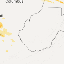
Ohio
| Local Time | Report Details |
|---|---|
| 4:29 PM EDT | Quarter sized hail reported near New Paris, OH, 54.2 miles NNW of Cincinnati, OH |
| 4:34 PM EDT | Several large trees down near eaton high school. an equipment trailer also blown over by high wind...and damage to fencing at the athletic complex. shingle damage to ro in preble county OH, 44.4 miles N of Cincinnati, OH |
| 4:55 PM EDT | Quarter sized hail reported near Toronto, OH, 31.8 miles W of Pittsburgh, PA |
| 5:30 PM EDT | Quarter sized hail reported near Oxford, OH, 30.8 miles NNW of Cincinnati, OH |
| 5:52 PM EDT | Quarter sized hail reported near Harrison, OH, 18.2 miles WNW of Cincinnati, OH, report via twitter. |
| 5:59 PM EDT | Half Dollar sized hail reported near Hamilton, OH, 15.5 miles N of Cincinnati, OH, report via mping |
| 6:01 PM EDT | Quarter sized hail reported near Fairfield, OH, 15.5 miles N of Cincinnati, OH, quarter size hail at the intersection of river road and nilles road |
| 6:02 PM EDT | Golf Ball sized hail reported near Cincinnati, OH, 13.7 miles NNE of Cincinnati, OH, public report at intersection of cresentville and chesterdale roads on butler/hamilton county line. |
| 6:02 PM EDT | Golf Ball sized hail reported near Cincinnati, OH, 14.3 miles NNE of Cincinnati, OH, via media |
| 6:03 PM EDT | Ping Pong Ball sized hail reported near Fairfield, OH, 14.8 miles N of Cincinnati, OH, one to one and a half inch diameter hail at winton road near the i-275 interchange |
| 6:05 PM EDT | Ping Pong Ball sized hail reported near Cleves, OH, 11.6 miles WNW of Cincinnati, OH, report from amateur radio spotters. |
| 6:06 PM EDT | Quarter sized hail reported near West Chester, OH, 17.5 miles NNE of Cincinnati, OH, via media |
| 6:09 PM EDT | Half Dollar sized hail reported near Hamilton, OH, 14.8 miles N of Cincinnati, OH, reported via mping app. |
| 6:15 PM EDT | Ping Pong Ball sized hail reported near West Chester, OH, 14.9 miles NNE of Cincinnati, OH, report via mping |
| 6:15 PM EDT | Half Dollar sized hail reported near Cincinnati, OH, 12.5 miles NNW of Cincinnati, OH, hail ranged in size from nickel to half dollar size. |
| 6:15 PM EDT | Quarter sized hail reported near West Chester, OH, 16.4 miles NNE of Cincinnati, OH |
| 6:15 PM EDT | Hen Egg sized hail reported near Cincinnati, OH, 14.3 miles NNE of Cincinnati, OH |
| 6:16 PM EDT | Quarter sized hail reported near Cincinnati, OH, 15.2 miles NNE of Cincinnati, OH, report at route 42 and dimmick roads. |
| 6:26 PM EDT | Quarter sized hail reported near Loveland, OH, 16.9 miles NE of Cincinnati, OH |
| 7:00 PM EDT | Quarter sized hail reported near Lynchburg, OH, 36.3 miles E of Cincinnati, OH, via mping |
| 7:05 PM EDT | Quarter sized hail reported near Hillsboro, OH, 37.9 miles E of Cincinnati, OH, via mping |
| 7:29 PM EDT | Ping Pong Ball sized hail reported near New Richmond, OH, 16.2 miles SE of Cincinnati, OH |
| 7:33 PM EDT | Ping Pong Ball sized hail reported near New Richmond, OH, 16.2 miles SE of Cincinnati, OH |
| 7:37 PM EDT | Half Dollar sized hail reported near Felicity, OH, 28.5 miles SE of Cincinnati, OH, via media |
| 7:58 PM EDT | Quarter sized hail reported near Middletown, OH, 20.9 miles NNE of Cincinnati, OH |
| 9:18 PM EDT | Few trees down in columbiana county OH, 37.3 miles WNW of Pittsburgh, PA |
| 12:00 AM EDT | Trees down in mount pleasant in jefferson county OH, 46 miles WSW of Pittsburgh, PA |
| 12:00 AM EDT | Trees down outside adena in jefferson county OH, 47.9 miles WSW of Pittsburgh, PA |
Florida
| Local Time | Report Details |
|---|---|
| 4:35 PM EDT | Gas station canopy blown off at intersection of highway 1 and juno ocean wal in palm beach county FL, 32.4 miles SE of Port Saint Lucie, FL |
| 7:10 PM EDT | Tree down near the 3100 block of sw archer rd. time estimated by rada in alachua county FL, 64.6 miles SW of Jacksonville, FL |
| 7:20 PM EDT | Multiple trees down on sw 82nd terrace. time estimated by rada in alachua county FL, 68 miles SW of Jacksonville, FL |
New Hampshire
| Local Time | Report Details |
|---|---|
| 5:15 PM EDT | Quarter sized hail reported near Littleton, NH, 72.4 miles E of Burlington, VT |
| 5:30 PM EDT | Trees down. corrected time from earlier report in sullivan county NH, 81.9 miles SSE of Burlington, VT |
| 5:30 PM EDT | Trees down in grafton county NH, 75 miles SE of Burlington, VT |
| 5:40 PM EDT | Trees down all over town in coos county NH, 81.2 miles E of Burlington, VT |
| 5:40 PM EDT | *** 2 fatal... 15 inj *** reports of 2 deaths and many injuries due to tent collapse at the lancaster fairgrounds. up to 250 people trappe in coos county NH, 81.2 miles E of Burlington, VT |
| 5:59 PM EDT | Trees down in sullivan county NH, 81.9 miles SSE of Burlington, VT |
| 6:00 PM EDT | Trees and wires down in grafton county NH, 75.6 miles WNW of Portland, ME |
| 6:00 PM EDT | Tree down blocking mack road in gilsum in cheshire county NH, 86.8 miles ENE of Schenectady, NY |
| 6:10 PM EDT | Trees down all over town in grafton county NH, 72.1 miles W of Portland, ME |
| 6:10 PM EDT | Trees down all over town in grafton county NH, 74.5 miles W of Portland, ME |
| 6:15 PM EDT | Trees down all over town in grafton county NH, 68.9 miles W of Portland, ME |
| 6:20 PM EDT | Trees down all over town in grafton county NH, 67 miles W of Portland, ME |
| 6:30 PM EDT | Trees and wires down in grafton county NH, 65.3 miles WNW of Portland, ME |
| 6:35 PM EDT | Quarter sized hail reported near Colebrook, NH, 96.6 miles ENE of Burlington, VT |
| 6:40 PM EDT | Trees and wires down on stevenson drive. time estimated from rada in carroll county NH, 49 miles WNW of Portland, ME |
| 6:45 PM EDT | Tree down. time estimated from rada in belknap county NH, 63.1 miles WSW of Portland, ME |
| 6:50 PM EDT | Numerous trees and wires down throughout town. time estimated from rada in carroll county NH, 51.3 miles WNW of Portland, ME |
| 7:00 PM EDT | Trees down on wires at state line store. time estimated from rada in carroll county NH, 44 miles WNW of Portland, ME |
| 7:00 PM EDT | Numerous trees down in carroll county NH, 51.3 miles WNW of Portland, ME |
| 7:08 PM EDT | Tree down on wires. time estimated from rada in carroll county NH, 42.5 miles WNW of Portland, ME |
| 8:35 PM EDT | Trees down in merrimack county NH, 67.5 miles WSW of Portland, ME |
Kentucky
| Local Time | Report Details |
|---|---|
| 7:03 PM EDT | Quarter sized hail reported near Latonia, KY, 6.7 miles S of Cincinnati, OH, via media |
| 7:10 PM EDT | Golf Ball sized hail reported near Latonia, KY, 7.4 miles S of Cincinnati, OH, reported along otter court. |
| 7:14 PM EDT | Quarter sized hail reported near Alexandria, KY, 12.1 miles SSE of Cincinnati, OH |
| 7:15 PM EDT | Ping Pong Ball sized hail reported near Alexandria, KY, 12.1 miles SSE of Cincinnati, OH, via media |
| 7:22 PM EDT | Quarter sized hail reported near California, KY, 20.6 miles SE of Cincinnati, OH |
| 7:31 PM EDT | Quarter sized hail reported near Williamstown, KY, 32.3 miles S of Cincinnati, OH |
| 7:34 PM EDT | Golf Ball sized hail reported near Williamstown, KY, 32.3 miles S of Cincinnati, OH |
| 8:08 PM EDT | A few trees reported down southeast of kelat...or southwest of sunrise. time estimated from rada in harrison county KY, 44 miles SSE of Cincinnati, OH |
| 8:37 PM EDT | Trees down highway 32 inside city limit in fleming county KY, 51.3 miles NNE of Irvine, KY |
| 8:37 PM EDT | Trees down mount carmel ave near courthous in fleming county KY, 51.3 miles NNE of Irvine, KY |
| 9:12 PM EDT | Trees down on south mill branch road and lambert hollow roa in rowan county KY, 43.5 miles NE of Irvine, KY |
| 9:18 PM EDT | Trees were blown down throughout mount sterling and the northern part of the county in genera in montgomery county KY, 24.9 miles N of Irvine, KY |
| 9:24 PM EDT | Trees were blown down throughout sharpsbur in bath county KY, 34.6 miles N of Irvine, KY |
| 9:24 PM EDT | Trees down in 1700 block of highway 36 in bath county KY, 29.9 miles NNE of Irvine, KY |
| 9:24 PM EDT | Trees down on wyoming roa in bath county KY, 38.9 miles NNE of Irvine, KY |
| 9:24 PM EDT | Trees down highway 60 at salt lic in bath county KY, 34.9 miles NNE of Irvine, KY |
| 9:42 PM EDT | Trees down highway 706 and bruin hill area in elliott county KY, 58.4 miles ENE of Irvine, KY |
| 9:45 PM EDT | Trees were blown down throughout owingsvill in bath county KY, 32.5 miles NNE of Irvine, KY |
Colorado
| Local Time | Report Details |
|---|---|
| 5:45 PM MDT | Quarter sized hail reported near Dove Creek, CO, 81.7 miles NNW of Farmington, NM, 1 inch hail reported causing damage to trees. |
Texas
| Local Time | Report Details |
|---|---|
| 7:36 PM CDT | Storm damage reported in dallam county TX, 85.8 miles NNW of Amarillo, TX |
| 8:30 PM CDT | Storm damage reported in lipscomb county TX, 63.6 miles W of Woodward, OK |
| 9:09 PM CDT | Storm spotter reported estimated wind gust of 60 mph as line of thunderstorms passed over. the storm is also bringing heavy rai in sherman county TX, 60.3 miles N of Amarillo, TX |
| 9:15 PM CDT | Storm damage reported in moore county TX, 56 miles N of Amarillo, TX |
| 9:15 PM CDT | Dumas eoc reported 6 power poles down approximately 2 to 3 miles south of sunray on highway 119. time of event estimated by rada in moore county TX, 53.3 miles N of Amarillo, TX |
| 9:35 PM CDT | Dumas eoc reported 9 power poles snapped near county road 1060 and highway 281. time of event estimated by rada in moore county TX, 56.3 miles N of Amarillo, TX |
| 9:38 PM CDT | Schoolnet site at moore co. airport in moore county TX, 45.4 miles NNW of Amarillo, TX |
West Virginia
| Local Time | Report Details |
|---|---|
| 12:10 AM EDT | Trees down in clearview in ohio county WV, 42 miles WSW of Pittsburgh, PA |
| 1:45 AM EDT | Multiple tree limbs down in roadway at the intersection of route 20 and 119. time estimated from radar in upshur county WV, 21.3 miles WNW of Elkins, WV |
| 2:05 AM EDT | Large branches does in roadway along route 119 in phillippi. time estimated from radar in barbour county WV, 18.5 miles NNW of Elkins, WV |
| 2:21 AM EDT | 1 tree/power lines down in preston county WV, 30.7 miles NNE of Elkins, WV |
| 2:50 AM EDT | Tree down on powerlines on limestone road near hollywood roa in mineral county WV, 58.5 miles NE of Elkins, WV |
| 3:56 AM EDT | Tree down in the 200 block of john brown farm road in jefferson county WV, 65.8 miles W of Baltimore, MD |
Maryland
| Local Time | Report Details |
|---|---|
| 2:21 AM EDT | Tree down partially blocking 14000 blk rockdale rd in washington county MD, 71.6 miles WNW of Baltimore, MD |
| 2:28 AM EDT | Tree down i-81 sb at mile marker 9 blocking lan in washington county MD, 66.4 miles WNW of Baltimore, MD |
| 2:30 AM EDT | Quarter sized hail reported near Hagerstown, MD, 66.3 miles WNW of Baltimore, MD |
| 2:31 AM EDT | Tree down blocking longmeadow rd in washington county MD, 64.2 miles WNW of Baltimore, MD |
| 2:37 AM EDT | Tree down blocking 13000 blk brooklane dr in washington county MD, 59.8 miles WNW of Baltimore, MD |
| 2:37 AM EDT | Tree down blocking portion of leitersburg-smithsburg rd in washington county MD, 59.8 miles WNW of Baltimore, MD |
| 2:42 AM EDT | Tree down blocking portion of edgemont rd in washington county MD, 56.7 miles WNW of Baltimore, MD |
| 3:11 AM EDT | 18 inch diameter tree down blocking portion of md 194 at ruggles rd in carroll county MD, 40.3 miles NW of Baltimore, MD |
| 4:05 AM EDT | Quarter sized hail reported near Columbia, MD, 12.8 miles WSW of Baltimore, MD |
| 4:24 AM EDT | Tree down blocking 5100 blk doubs rd in frederick county MD, 47.2 miles W of Baltimore, MD |
| 4:37 AM EDT | Tree down near kings valley road and hailey driv in montgomery county MD, 33.3 miles W of Baltimore, MD |
| 4:38 AM EDT | Trees and wires down at windsor rd and browningsville rd in frederick county MD, 34.9 miles W of Baltimore, MD |
| 4:39 AM EDT | Storm damage reported in montgomery county MD, 33.4 miles W of Baltimore, MD |
| 4:44 AM EDT | Wires down 3800 blk purdum dr in frederick county MD, 32.4 miles W of Baltimore, MD |
Virginia
| Local Time | Report Details |
|---|---|
| 3:44 AM EDT | Tree down on old charles town road at windy hill lane in clarke county VA, 75.8 miles W of Baltimore, MD |
| 3:51 AM EDT | Tree down on shepherds mill road at chestnut lane in clarke county VA, 70.7 miles W of Baltimore, MD |
| 4:07 AM EDT | Large limb down in the road at the intersection of hwy 287 and winsome trail lan in loudoun county VA, 60 miles W of Baltimore, MD |
| 4:11 AM EDT | Top half of large tree laying across hwy 287 at the intersection of nixon r in loudoun county VA, 60 miles W of Baltimore, MD |
| 4:20 AM EDT | Tree down along taylorstown roa in loudoun county VA, 51.6 miles W of Baltimore, MD |
| 4:22 AM EDT | Tree down on route 50 near aldi in loudoun county VA, 59.9 miles WSW of Baltimore, MD |
| 4:27 AM EDT | Tree limb about 10 inches in diameter was down near sierra springs squar in loudoun county VA, 50.6 miles WSW of Baltimore, MD |
Connecticut
| Local Time | Report Details |
|---|---|
| 4:50 AM EDT | Several trees down on park avenue near the danbury field mal in fairfield county CT, 55.9 miles NNE of Brooklyn, NY |
Rhode Island
| Local Time | Report Details |
|---|---|
| 6:08 AM EDT | Tree down on bank street in washington county RI, 26.9 miles SW of Providence, RI |
| 6:18 AM EDT | Large tree down on coventry hill farm road. wires down on indian trai in kent county RI, 16.3 miles WSW of Providence, RI |
| 6:20 AM EDT | Tree down blocking maple valley road in kent county RI, 16.3 miles WSW of Providence, RI |
| 6:27 AM EDT | Tree on to house on black rock road in kent county RI, 16.3 miles WSW of Providence, RI |
| 6:27 AM EDT | Several trees down blocking part of interstate 295 near the warwick cranston town line in kent county RI, 8.6 miles S of Providence, RI |
| 6:28 AM EDT | Storm damage reported in kent county RI, 6.5 miles S of Providence, RI |
| 6:32 AM EDT | Tree down on house. wires down on car burling game road in kent county RI, 9.6 miles SW of Providence, RI |
| 6:35 AM EDT | Tree down on house in kent county RI, 8.6 miles S of Providence, RI |
| 6:36 AM EDT | Storm damage reported in anz236 county RI, 8.1 miles SSE of Providence, RI |
| 6:39 AM EDT | Tree down on jefferson boulevard in kent county RI, 8.6 miles S of Providence, RI |
| 6:39 AM EDT | Large branches down on boulevard street in kent county RI, 8.6 miles S of Providence, RI |
| 6:40 AM EDT | Storm damage reported in washington county RI, 32.8 miles SSW of Providence, RI |
| 6:40 AM EDT | Tree down on phoenix ave in providence county RI, 3.4 miles SSW of Providence, RI |
| 6:40 AM EDT | Tree down on house on landsdowne street in kent county RI, 8.6 miles S of Providence, RI |
| 6:42 AM EDT | Trees down on ledge drive in kent county RI, 9.6 miles SW of Providence, RI |
| 6:46 AM EDT | Trees down in burlingame state park in washington county RI, 32.8 miles SSW of Providence, RI |
| 6:47 AM EDT | Wires down in providence county RI, 2.4 miles ESE of Providence, RI |
Massachusetts
| Local Time | Report Details |
|---|---|
| 6:55 AM EDT | Tree down on lincoln ave blocking street in bristol county MA, 15.1 miles E of Providence, RI |
| 7:02 AM EDT | Tree down on roebeson street blocking half the road in bristol county MA, 15.6 miles ESE of Providence, RI |
| 7:04 AM EDT | Tree down on moving car in bristol county MA, 17.7 miles E of Providence, RI |
| 7:04 AM EDT | Wires down on high street freetown in bristol county MA, 17.7 miles E of Providence, RI |
| 7:06 AM EDT | Wires down on main street in bristol county MA, 15.1 miles E of Providence, RI |
| 7:18 AM EDT | Tree down on county road with multiple trees down across town in plymouth county MA, 23.9 miles E of Providence, RI |
| 7:19 AM EDT | Trees and wires down in several locations in bristol county MA, 19.7 miles ENE of Providence, RI |
| 7:21 AM EDT | Tree down on maple road in bristol county MA, 25.9 miles SE of Providence, RI |
| 7:30 AM EDT | Trees and large limbs down on route 6a in barnstable county MA, 47.8 miles E of Providence, RI |
Connect with Interactive Hail Maps