

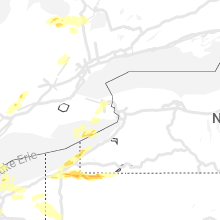
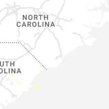
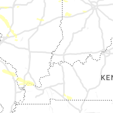
Hail Map for Thursday, July 20, 2023

Number of Impacted Households on 7/20/2023
0
Impacted by 1" or Larger Hail
0
Impacted by 1.75" or Larger Hail
0
Impacted by 2.5" or Larger Hail
Square Miles of Populated Area Impacted on 7/20/2023
0
Impacted by 1" or Larger Hail
0
Impacted by 1.75" or Larger Hail
0
Impacted by 2.5" or Larger Hail


Cities Most Affected by Hail Storms of 7/20/2023
| Hail Size | Demographics of Zip Codes Affected | ||||||
|---|---|---|---|---|---|---|---|
| City | Count | Average | Largest | Pop Density | House Value | Income | Age |
| Davison, MI | 4 | 2.38 | 2.75 | 519 | $120k | $45.6k | 39.0 |
| Mishawaka, IN | 2 | 2.25 | 2.50 | 1441 | $83k | $35.1k | 35.6 |
| Colorado Springs, CO | 2 | 2.13 | 2.50 | 2688 | $134k | $38.4k | 40.7 |
| Simla, CO | 2 | 1.75 | 1.75 | 3 | $86k | $32.2k | 39.0 |
| Scott City, KS | 1 | 2.50 | 2.50 | 6 | $72k | $40.5k | 41.5 |
| Garden City, KS | 1 | 2.50 | 2.50 | 44 | $85k | $38.1k | 30.2 |
| Leoti, KS | 1 | 2.50 | 2.50 | 2 | $56k | $33.3k | 39.7 |
| Rush, CO | 1 | 2.00 | 2.00 | 1 | $105k | $34.3k | 43.5 |
| Westlake, OH | 1 | 2.00 | 2.00 | 2097 | $201k | $65.1k | 45.0 |
| Corry, PA | 1 | 2.00 | 2.00 | 105 | $60k | $33.6k | 40.1 |
| Ypsilanti, MI | 1 | 2.00 | 2.00 | 1441 | $163k | $44.2k | 30.1 |
| Yoder, CO | 1 | 2.00 | 2.00 | 6 | $90k | $36.0k | 40.0 |
| Elkhart, IN | 1 | 2.00 | 2.00 | 641 | $91k | $41.7k | 34.6 |
| Cleveland, OH | 1 | 1.75 | 1.75 | 3030 | $127k | $42.7k | 45.0 |
| Kiowa, CO | 1 | 1.75 | 1.75 | 7 | $183k | $49.4k | 44.2 |
| Mount Clemens, MI | 1 | 1.75 | 1.75 | 3706 | $101k | $37.9k | 38.3 |
| Groveoak, AL | 1 | 1.75 | 1.75 | 29 | $62k | $30.6k | 40.3 |
| Fowler, CO | 1 | 1.75 | 1.75 | 3 | $70k | $31.0k | 44.4 |
| Marienthal, KS | 1 | 1.75 | 1.75 | 2 | $34k | $38.1k | 46.5 |
| Saint Clair, MI | 1 | 1.75 | 1.75 | 308 | $145k | $55.0k | 43.1 |
Hail and Wind Damage Spotted on 7/20/2023
Filter by Report Type:Hail ReportsWind Reports
States Impacted
Missouri, Michigan, Illinois, Kentucky, Pennsylvania, Tennessee, Indiana, Colorado, Georgia, Kansas, Ohio, Alabama, Idaho, Virginia, New York, South Carolina, North Carolina, Arizona, Oklahoma, MarylandMissouri
| Local Time | Report Details |
|---|---|
| 8:30 AM CDT | Tree down just south of belle. 2 other reports of trees down to the south and wes in maries county MO, 44.3 miles NNW of Salem, MO |
| 8:36 AM CDT | Split tree. time estimated from rada in gasconade county MO, 46 miles N of Salem, MO |
| 8:59 AM CDT | Trees dow in cape girardeau county MO, 11.4 miles NNW of Cape Girardeau, MO |
| 9:06 AM CDT | Trees down... time estimated from rada in washington county MO, 44.2 miles ENE of Salem, MO |
| 9:06 AM CDT | Trees down... time estimated from rada in washington county MO, 39.1 miles NE of Salem, MO |
Michigan
| Local Time | Report Details |
|---|---|
| 9:42 AM EDT | Local media reports multiple trees and powerlines down in the city of frankfort. confirmed by e in benzie county MI, 31.4 miles WSW of Traverse City, MI |
| 12:12 PM EDT | Two trees down in road. time estimated from rada in osceola county MI, 63.8 miles SSE of Traverse City, MI |
| 12:14 PM EDT | Tree down in road. time estimated from radar.. in newaygo county MI, 27.5 miles NNW of Grand Rapids, MI |
| 12:15 PM EDT | Tree down in road. time estimated from rada in osceola county MI, 63.3 miles NNE of Grand Rapids, MI |
| 12:34 PM EDT | Tree down in road. time estimated from rada in mecosta county MI, 37.8 miles NNE of Grand Rapids, MI |
| 12:35 PM EDT | Trees down. time estimated from rada in clare county MI, 66.3 miles SE of Traverse City, MI |
| 12:49 PM EDT | Report from mping: 1-inch tree limbs broken; shingles blown of in montcalm county MI, 26.3 miles NNE of Grand Rapids, MI |
| 12:52 PM EDT | Several trees down in the lakeview to six lakes are in montcalm county MI, 39 miles NE of Grand Rapids, MI |
| 1:55 PM EDT | Several trees down in southeast gratiot county. time estimated from rada in gratiot county MI, 42 miles WNW of Flint, MI |
| 2:05 PM EDT | Half Dollar sized hail reported near Saint Johns, MI, 44.3 miles W of Flint, MI, time estimated from radar. |
| 2:10 PM EDT | Quarter sized hail reported near Dewitt, MI, 46.9 miles WSW of Flint, MI |
| 2:15 PM EDT | Quarter sized hail reported near Vicksburg, MI, 58.9 miles S of Grand Rapids, MI |
| 2:15 PM EDT | Quarter sized hail reported near Bellevue, MI, 48.7 miles SE of Grand Rapids, MI, photo of quarter-sized hail from social media. time estimated from radar. |
| 2:20 PM EDT | Reports of wires and large trees down two miles south of the intersection of 500 block and comstock stree in shiawassee county MI, 24 miles W of Flint, MI |
| 2:20 PM EDT | Several trees down in the ovid area. time estimated from rada in clinton county MI, 35.7 miles W of Flint, MI |
| 2:20 PM EDT | Quarter sized hail reported near Olivet, MI, 52.7 miles SE of Grand Rapids, MI, report from mping: quarter (1.00 in.). |
| 2:25 PM EDT | Several trees down in the bath area. time estimated from rada in clinton county MI, 40.7 miles WSW of Flint, MI |
| 2:33 PM EDT | Quarter sized hail reported near Mount Morris, MI, 7.5 miles N of Flint, MI, hail fell in the city of mount morris. |
| 2:34 PM EDT | Dispatch reported several power lines downed near 1st st and madison st in perry. time estimated based on rada in shiawassee county MI, 30.6 miles WSW of Flint, MI |
| 2:35 PM EDT | Quarter sized hail reported near Haslett, MI, 40.9 miles WSW of Flint, MI, time estimated from radar. |
| 2:37 PM EDT | Tennis Ball sized hail reported near Davison, MI, 8.5 miles E of Flint, MI, reports of widespread hail damage across davison. |
| 2:39 PM EDT | Quarter sized hail reported near Burton, MI, 3.4 miles ESE of Flint, MI, hail estimated from a live video... estimated size of 1 inch. |
| 2:45 PM EDT | Trees and power lines down across ingham count in ingham county MI, 48.5 miles SW of Flint, MI |
| 2:45 PM EDT | Time estimated from rada in ingham county MI, 46 miles SW of Flint, MI |
| 2:47 PM EDT | Golf Ball sized hail reported near Davison, MI, 8.5 miles E of Flint, MI |
| 2:47 PM EDT | Dispatch reported a large tree had fallen on a house in byron. time estimated based on rada in shiawassee county MI, 18.3 miles SW of Flint, MI |
| 2:50 PM EDT | Baseball sized hail reported near Davison, MI, 8.5 miles E of Flint, MI, media reports of hail up to baseball size in davison. |
| 2:56 PM EDT | Numerous trees down across the northern end of livingston county including around cohocta in livingston county MI, 21.9 miles SW of Flint, MI |
| 2:57 PM EDT | Ping Pong Ball sized hail reported near Lapeer, MI, 13.7 miles ENE of Flint, MI |
| 3:00 PM EDT | Tennis Ball sized hail reported near Davison, MI, 8.5 miles E of Flint, MI |
| 3:10 PM EDT | Corrects previous tstm wnd dmg report from rives junction. several trees down around rives junction and henrietta township. time estimated from rada in jackson county MI, 58.2 miles SW of Flint, MI |
| 3:10 PM EDT | Corrects previous tstm wnd dmg report from rives junction. several trees down around rives junction and henrietta township. time estimated from rada in jackson county MI, 58.2 miles SW of Flint, MI |
| 3:10 PM EDT | Ping Pong Ball sized hail reported near Detroit, MI, 48.5 miles SSE of Flint, MI, reports of hail up to 1.50 inches near grand river and southfield road. |
| 3:14 PM EDT | Report from mping: trees dow in ingham county MI, 53.5 miles WSW of Flint, MI |
| 3:20 PM EDT | Half Dollar sized hail reported near Oxford, MI, 25.7 miles ESE of Flint, MI |
| 3:32 PM EDT | Quarter sized hail reported near Lake Orion, MI, 25 miles SE of Flint, MI, quarter size hail reported near the intersection of sashabaw rd and seymour lake rd. |
| 3:36 PM EDT | Two large trees downed near 1st st and campbell street. several 8 inch diameter limbs also reported around the rochester area. time estimated based on rada in oakland county MI, 36.4 miles SE of Flint, MI |
| 3:40 PM EDT | Ping Pong Ball sized hail reported near Saint Clair Shores, MI, 53.7 miles SE of Flint, MI, report of hail up to 1.50 inches at 11 mile and jefferson ave. |
| 3:40 PM EDT | Large tree was uprooted and blocking southbound walnut lake road at west bloomfield lake r in oakland county MI, 34.8 miles SSE of Flint, MI |
| 3:42 PM EDT | Golf Ball sized hail reported near Saint Clair, MI, 62.1 miles ESE of Flint, MI, hail fell in the city of st clair |
| 3:45 PM EDT | Report of a tree down blocking cavanaugh lake road near conway roa in washtenaw county MI, 52.8 miles SSW of Flint, MI |
| 3:48 PM EDT | Quarter sized hail reported near Northville, MI, 41.1 miles SSE of Flint, MI, one inch hail reported near the intersection of 8 mile and beck. |
| 3:53 PM EDT | Several trees reported down in clyde township. time estimated based on rada in st. clair county MI, 55.5 miles E of Flint, MI |
| 3:55 PM EDT | Report of roof damage in downtown port huron near the intersection of fort and beers roa in st. clair county MI, 63.7 miles E of Flint, MI |
| 3:55 PM EDT | Report of numerous trees and wires down around the wadhams are in st. clair county MI, 58.1 miles E of Flint, MI |
| 3:56 PM EDT | Report of several trees down near the intersection of oakwood drive and west water drive. time estimated based on rada in st. clair county MI, 61.1 miles E of Flint, MI |
| 3:57 PM EDT | Multiple reports of trees down... several with over one foot diameter... along and within vicinity of m2 in st. clair county MI, 63.5 miles ESE of Flint, MI |
| 4:04 PM EDT | Hen Egg sized hail reported near Ypsilanti, MI, 53.3 miles S of Flint, MI, report of hail up to 2.00 inches near benjamin drive and prospect road. |
| 4:05 PM EDT | Golf Ball sized hail reported near Mount Clemens, MI, 49.8 miles SE of Flint, MI |
| 4:07 PM EDT | Quarter sized hail reported near Ann Arbor, MI, 51 miles S of Flint, MI |
| 4:13 PM EDT | Ping Pong Ball sized hail reported near Ann Arbor, MI, 50.5 miles S of Flint, MI, report of hail up to ping pong ball size. |
| 4:14 PM EDT | Kdtw asos measured a 54 knot wind gust at detroit metro airpor in wayne county MI, 56.9 miles SSE of Flint, MI |
| 4:15 PM EDT | Quarter sized hail reported near Allen Park, MI, 57.2 miles SSE of Flint, MI |
| 4:17 PM EDT | Report of a large tree down across chandler avenu in wayne county MI, 58.7 miles SSE of Flint, MI |
Illinois
| Local Time | Report Details |
|---|---|
| 10:03 AM CDT | 8 inch tree limbs down... time estimated from rada in macoupin county IL, 33.9 miles NE of Saint Louis, MO |
| 10:09 AM CDT | Multiple 2 to 3 ft in diameter trees down across roads and powerline in madison county IL, 33.5 miles NE of Saint Louis, MO |
| 10:21 AM CDT | Reports of trees and powerlines dow in massac county IL, 46 miles ESE of Cape Girardeau, MO |
| 10:21 AM CDT | Tree and powerline down over the roa in massac county IL, 37 miles E of Cape Girardeau, MO |
| 10:21 AM CDT | Trees and powerlines down blocking roa in massac county IL, 46.4 miles E of Cape Girardeau, MO |
| 10:21 AM CDT | Trees down over roa in massac county IL, 47.9 miles E of Cape Girardeau, MO |
| 10:21 AM CDT | Trees and powerlines dow in massac county IL, 45.8 miles ESE of Cape Girardeau, MO |
| 11:12 AM CDT | Power lines down... time estimated from rada in washington county IL, 48.3 miles ESE of Saint Louis, MO |
| 2:05 PM CDT | Quarter sized hail reported near Trilla, IL, 7.8 miles S of Mattoon, IL, corrects time of previous hail report from trilla. social media report. time estimated from radar. |
| 3:05 PM CDT | Quarter sized hail reported near Trilla, IL, 7.8 miles S of Mattoon, IL, social media report. time estimated from radar. |
Kentucky
| Local Time | Report Details |
|---|---|
| 10:21 AM CDT | Quarter sized hail reported near Bandana, KY, 35 miles ESE of Cape Girardeau, MO |
| 10:26 AM CDT | Tree down over the roa in mccracken county KY, 52.6 miles ESE of Cape Girardeau, MO |
| 10:26 AM CDT | Tree down over the roa in mccracken county KY, 50.6 miles ESE of Cape Girardeau, MO |
| 10:29 AM CDT | Damage reported at the convention center in downtown paduca in mccracken county KY, 54.1 miles ESE of Cape Girardeau, MO |
| 10:31 AM CDT | Tree down on top of vehicl in mccracken county KY, 59.3 miles ESE of Cape Girardeau, MO |
| 10:55 AM CDT | Estimated wind gust of 60 mph power outages reporte in livingston county KY, 62.6 miles NNE of Mc Kenzie, TN |
| 11:06 AM CDT | Tree blown down near i-69 and us 62 interchange at kuttaw in lyon county KY, 68.2 miles NNE of Mc Kenzie, TN |
| 11:35 AM CDT | Roof feature blown dow in calloway county KY, 35.4 miles NNE of Mc Kenzie, TN |
Pennsylvania
| Local Time | Report Details |
|---|---|
| 11:35 AM EDT | Multiple reports of trees down across eastern lycoming count in lycoming county PA, 56.2 miles W of Scranton, PA |
| 1:39 PM EDT | Quarter sized hail reported near Erie, PA, 80.5 miles SW of Buffalo, NY, various hail sizes from penny to quarter size. |
| 1:45 PM EDT | Quarter sized hail reported near Erie, PA, 79.9 miles SW of Buffalo, NY, quarter hail at presque isle state park. |
| 5:10 PM EDT | Quarter sized hail reported near Girard, PA, 79.9 miles ENE of Cleveland, OH, report from mping: quarter (1.00 in.). |
| 5:54 PM EDT | Ping Pong Ball sized hail reported near Mc Kean, PA, 86.1 miles ENE of Cleveland, OH |
| 6:05 PM EDT | Quarter sized hail reported near Union City, PA, 84.5 miles SW of Buffalo, NY |
| 6:15 PM EDT | Quarter sized hail reported near Corry, PA, 81 miles SSW of Buffalo, NY, hail damaged some vehicles and also tore off window screens. |
| 6:30 PM EDT | Hen Egg sized hail reported near Corry, PA, 76.6 miles SSW of Buffalo, NY, north side of corry... pa. |
| 7:11 PM EDT | Ping Pong Ball sized hail reported near Sugar Grove, PA, 66.8 miles SSW of Buffalo, NY, reports of golf ball size hail in sugar grove. |
| 7:12 PM EDT | Multiple trees and wires down in the conneautville... venango... and cambridge springs area in crawford county PA, 70.6 miles ENE of Cleveland, OH |
| 7:29 PM EDT | Wires down on route 426 and chappy r in warren county PA, 77.8 miles SSW of Buffalo, NY |
| 7:33 PM EDT | Trees down in and around sandy lake in mercer county PA, 63.1 miles N of Pittsburgh, PA |
| 7:39 PM EDT | Trees down on hatch run r in warren county PA, 69.7 miles S of Buffalo, NY |
| 7:40 PM EDT | Multiple trees and wires down in the tidioute are in warren county PA, 86.9 miles SSW of Buffalo, NY |
| 7:42 PM EDT | Trees down in and around west salem townshi in mercer county PA, 63.3 miles E of Cleveland, OH |
| 7:48 PM EDT | Trees down in and around sharon in mercer county PA, 60.6 miles NNW of Pittsburgh, PA |
| 7:51 PM EDT | Trees and wires down in venango county PA, 70.2 miles NNE of Pittsburgh, PA |
| 7:53 PM EDT | Tree down in venango county PA, 66.5 miles N of Pittsburgh, PA |
| 7:57 PM EDT | Trees down on route 322 in venango county PA, 66.7 miles NNE of Pittsburgh, PA |
| 8:04 PM EDT | Report of tree down on job corps road in jenks township. time estimated based on rada in forest county PA, 84.4 miles NW of State College, PA |
| 8:15 PM EDT | Trees down in lewis run boroug in mckean county PA, 70.3 miles S of Buffalo, NY |
| 8:18 PM EDT | Report of numerous trees and powerlines down around grove city. time estimated based on rada in mercer county PA, 50 miles N of Pittsburgh, PA |
| 8:18 PM EDT | Report of tree down blocking westbound lane near country farm supply. time estimated based on rada in clarion county PA, 60.1 miles NNE of Pittsburgh, PA |
| 8:19 PM EDT | Reports of numerous trees and powerlines downs in pine townshi in mercer county PA, 51.2 miles N of Pittsburgh, PA |
| 8:20 PM EDT | Report of tree down on greenwood road. time estimated based on rada in forest county PA, 77.5 miles NNE of Pittsburgh, PA |
| 8:21 PM EDT | Report of tree down on greenwood road in barnett township. time estimated based on rada in forest county PA, 77 miles NE of Pittsburgh, PA |
| 8:22 PM EDT | *** 1 inj *** report of tree down on vehicle with only minor injury noted for inhabitant. time estimated based on radar in mercer county PA, 48.5 miles N of Pittsburgh, PA |
| 8:22 PM EDT | Report of multiple trees and power lines down in area. time estimated based on rada in butler county PA, 48.4 miles N of Pittsburgh, PA |
| 8:22 PM EDT | Report of tree down in area. time estimated based on rada in clarion county PA, 62 miles NNE of Pittsburgh, PA |
| 8:23 PM EDT | Trees down in clarion county PA, 59.7 miles NNE of Pittsburgh, PA |
| 8:24 PM EDT | Trees down in clarion county PA, 62.3 miles NNE of Pittsburgh, PA |
| 8:24 PM EDT | Report of tree down in area. time estimated based on rada in clarion county PA, 62.6 miles NNE of Pittsburgh, PA |
| 8:24 PM EDT | Report of multiple trees and power lines down in area. time estimated based on rada in butler county PA, 43.7 miles N of Pittsburgh, PA |
| 8:27 PM EDT | Trees and wires down on silver creek r in elk county PA, 66.2 miles NW of State College, PA |
| 8:29 PM EDT | Trees and wires down on old red mill dam r in elk county PA, 68 miles NW of State College, PA |
| 8:32 PM EDT | Report of trees down in the area. time estimated based on rada in butler county PA, 46.6 miles N of Pittsburgh, PA |
| 8:32 PM EDT | Report of trees and power lines down in the area. time estimated based on rada in jefferson county PA, 73.9 miles WNW of State College, PA |
| 8:34 PM EDT | Multiple reports of trees and wires down along us 6 near smethpor in mckean county PA, 76.3 miles NNW of State College, PA |
| 8:40 PM EDT | Report of trees and power lines down in the area. time estimated based on rada in jefferson county PA, 64.1 miles WNW of State College, PA |
| 8:44 PM EDT | Report of trees and power lines down in the area. time estimated based on rada in jefferson county PA, 57.9 miles WNW of State College, PA |
| 8:45 PM EDT | Trees down on route 155 near two mile r in mckean county PA, 75.1 miles NNW of State College, PA |
| 8:48 PM EDT | Report of downed tree on southbound lane of route 8. time estimated based on rada in butler county PA, 37.4 miles N of Pittsburgh, PA |
| 8:54 PM EDT | Report of trees down in franklin township. time estimated based on rada in beaver county PA, 27.8 miles NNW of Pittsburgh, PA |
| 8:55 PM EDT | Multiple trees down in penfield... including one on a hous in clearfield county PA, 47.3 miles NW of State College, PA |
| 8:57 PM EDT | Trees across north creek r in cameron county PA, 56.6 miles NNW of State College, PA |
| 9:01 PM EDT | Trees on wires in austin... p in potter county PA, 58.9 miles NNW of State College, PA |
| 9:17 PM EDT | Multiple trees down in genese in potter county PA, 80.5 miles SE of Buffalo, NY |
| 9:32 PM EDT | Report of a few trees down in the area. time estimated based on rada in beaver county PA, 18.3 miles NW of Pittsburgh, PA |
| 9:33 PM EDT | Tree on wires at 43 good street in clearfiel in clearfield county PA, 33.5 miles WNW of State College, PA |
| 9:34 PM EDT | Report of trees down in the area. time estimated based on rada in beaver county PA, 16.1 miles NW of Pittsburgh, PA |
| 9:45 PM EDT | Large tree down across the road at 9582 renovo r in clinton county PA, 38.1 miles NNE of State College, PA |
| 10:20 PM EDT | Several trees and wires down in the lock haven are in clinton county PA, 32.5 miles NE of State College, PA |
| 10:20 PM EDT | Tree down at atherton st and stevenson r in centre county PA, 4.5 miles WNW of State College, PA |
| 10:22 PM EDT | Report of multiple trees down along state route 933 going from trafford to north huntington township. time estimated based on rada in westmoreland county PA, 13.9 miles ESE of Pittsburgh, PA |
| 10:25 PM EDT | Trees down on buffalo run rd near fillmor in centre county PA, 4.7 miles NNW of State College, PA |
| 10:29 PM EDT | Trees down in mansfiel in tioga county PA, 78.5 miles WNW of Scranton, PA |
| 10:35 PM EDT | Trees and wires down on green mountain r in lycoming county PA, 58.5 miles NE of State College, PA |
| 10:45 PM EDT | Trees on wires behind 1227 isabella stree in lycoming county PA, 53.2 miles NE of State College, PA |
| 10:45 PM EDT | Report of power lines down in area. time estimated based on rada in washington county PA, 16 miles S of Pittsburgh, PA |
| 10:55 PM EDT | Trees down on abbott run r in lycoming county PA, 67.4 miles W of Scranton, PA |
| 10:57 PM EDT | Multiple trees down in the vicinity of altoona and hollidaysbur in blair county PA, 34.4 miles SW of State College, PA |
| 10:59 PM EDT | Multiple trees down in tyron in blair county PA, 20.9 miles WSW of State College, PA |
| 11:35 PM EDT | Multiple reports of trees down across eastern lycoming count in lycoming county PA, 56.3 miles WSW of Scranton, PA |
| 12:44 AM EDT | Tree down on roa in cumberland county PA, 48.3 miles SSE of State College, PA |
| 1:00 AM EDT | Tree down on i-81 blocking the right lan in cumberland county PA, 52.8 miles SE of State College, PA |
| 1:13 AM EDT | Tree down on campsit in cumberland county PA, 60.6 miles SE of State College, PA |
| 1:13 AM EDT | Trees dow in dauphin county PA, 56.3 miles ESE of State College, PA |
| 1:25 AM EDT | Tree down on roa in adams county PA, 56.6 miles NNW of Baltimore, MD |
| 1:29 AM EDT | Corrects previous tstm wnd dmg report from 1 nnw hogestown. tree down blocking southbound lane of carlisle pik in cumberland county PA, 57.3 miles SE of State College, PA |
| 1:29 AM EDT | Corrects previous tstm wnd dmg report from 1 nnw hogestown. tree down blocking southbound lane of carlisle pik in cumberland county PA, 57.3 miles SE of State College, PA |
| 1:39 AM EDT | Tree down on i-8 in dauphin county PA, 66.4 miles SE of State College, PA |
| 1:46 AM EDT | Tree fell through a roo in dauphin county PA, 65.4 miles N of Baltimore, MD |
| 2:16 AM EDT | Tree down on huntzinger roa in berks county PA, 75.8 miles NNE of Baltimore, MD |
| 2:49 AM EDT | Tree down on cedar hill roa in berks county PA, 78.4 miles NNE of Baltimore, MD |
| 3:02 AM EDT | Tree down on hous in chester county PA, 72.6 miles NE of Baltimore, MD |
| 3:46 AM EDT | Large branch down at morris road and west point pik in montgomery county PA, 77.4 miles WSW of Brooklyn, NY |
Tennessee
| Local Time | Report Details |
|---|---|
| 12:20 PM CDT | Photos received of large tree down near home as well as shutters blown off into the bushes on lake rd. in greenbrier. time is radar estimate in robertson county TN, 16.7 miles N of Nashville, TN |
| 12:20 PM CDT | Numerous trees and power lines down across the county... especially northeastern area in montgomery county TN, 40.1 miles NW of Nashville, TN |
| 12:21 PM CDT | Photo and report received via facebook of a large tree uprooted with notable tree damage along charles bell road and hartley drive. time is radar estimate in montgomery county TN, 38.9 miles NW of Nashville, TN |
| 12:32 PM CDT | Two trees down on kinneys rd.... one at airport rd. junction and the other at justice rd. junctio in robertson county TN, 23.6 miles NNW of Nashville, TN |
| 12:34 PM CDT | Trees and power lines down throughout robertson county with many across road in robertson county TN, 23.6 miles NNW of Nashville, TN |
| 12:34 PM CDT | Multiple homes with trees down on the roof and power lines down all across the 2500 block of kelly willis road. time is radar estimate in robertson county TN, 17.4 miles N of Nashville, TN |
| 1:40 PM EDT | Dispatch call center reported trees down throughout the county. time estimated from rada in rhea county TN, 50.3 miles NNE of Chattanooga, TN |
| 12:45 PM CDT | Dispatch reported trees down throughout the county. time estimated from rada in bledsoe county TN, 40.3 miles N of Chattanooga, TN |
| 12:45 PM CDT | Corrects time of previous tstm wnd dmg report from 1 ne ridgetop. photos received of large tree down near home as well as shutters blown off into the bushes on lake r in robertson county TN, 16.7 miles N of Nashville, TN |
| 12:48 PM CDT | Trees and power lines coming down all over the plac in robertson county TN, 15.4 miles N of Nashville, TN |
| 12:50 PM CDT | Dispatch reported trees down throughout county. time estimated from rada in bledsoe county TN, 37.5 miles NNE of Chattanooga, TN |
| 12:54 PM CDT | Numerous trees and power lines down in the greenbrier and ridgetop area in robertson county TN, 16 miles N of Nashville, TN |
| 12:55 PM CDT | Numerous trees and power lines down across southwestern sumner county. one tree fell onto and crushed a house on raintree d in sumner county TN, 12.7 miles NE of Nashville, TN |
| 1:00 PM CDT | Social media photos of numerous trees down around gallatin with some blocking road in sumner county TN, 23.5 miles NE of Nashville, TN |
| 1:01 PM CDT | Several trees down along vanderbilt r in wilson county TN, 12.4 miles ENE of Nashville, TN |
| 1:01 PM CDT | Photo received via facebook of a large tree down on powerlines blocking a portion of shirley drive. time is radar estimate in sumner county TN, 10.4 miles NE of Nashville, TN |
| 1:10 PM CDT | Trees and power lines down across mount julie in wilson county TN, 14.7 miles ENE of Nashville, TN |
| 1:10 PM CDT | Photo received via facebook of a large tree snapped in half at a home off of n greenhill rd. near needmore rd. time is radar estimate in wilson county TN, 14 miles ENE of Nashville, TN |
| 1:12 PM CDT | Nws employee estimated 70-80 mph winds in mount julie in wilson county TN, 14.5 miles E of Nashville, TN |
| 1:12 PM CDT | Photo received via twitter of a large tree down at a home off of vanderbilt rd. time is radar estimate in wilson county TN, 14 miles ENE of Nashville, TN |
| 1:20 PM CDT | Photo received via facebook of large tree that went through roof of home off of lakeshore drive in old hickory. time is radar estimate in davidson county TN, 9.7 miles ENE of Nashville, TN |
| 1:25 PM CDT | Tspotter photo of large tree down blocking hwy 100 at old harding pik in davidson county TN, 13.4 miles SW of Nashville, TN |
| 2:27 PM EDT | Dispatch reported trees down throughout county. time estimated from rada in bradley county TN, 29.6 miles ENE of Chattanooga, TN |
| 1:33 PM CDT | Large tree down blocking cranor roa in rutherford county TN, 36.4 miles SE of Nashville, TN |
| 1:42 PM CDT | Photo received via twitter of tree down on bradyville road. time is radar estimate in cannon county TN, 43 miles SE of Nashville, TN |
| 1:48 PM CDT | Photo received via twitter of tree uprooted on sunny slope rd. near woodbury. time is radar estimate in cannon county TN, 45.8 miles ESE of Nashville, TN |
| 1:52 PM CDT | Carport destroyed and mini barn flipped over on hwy 53 at simpson roa in cannon county TN, 51.2 miles SE of Nashville, TN |
| 1:53 PM CDT | Trees down on red hill r in cannon county TN, 51.7 miles SE of Nashville, TN |
| 1:57 PM CDT | 10 inch diameter pine tree snapped on hwy 70 near the cannon and warren county lin in cannon county TN, 53.3 miles ESE of Nashville, TN |
| 2:00 PM CDT | 20 trees snapped on buckner rd at mt view l in williamson county TN, 27.3 miles SSW of Nashville, TN |
| 2:05 PM CDT | Tree down and outbuilding damaged on old kentucky rd near central view marke in white county TN, 59.6 miles NNW of Chattanooga, TN |
| 3:15 PM EDT | Dispatch reported tree down near patty roa in polk county TN, 39.6 miles ENE of Chattanooga, TN |
| 2:17 PM CDT | Photo received via twitter of a large pine tree down in centertown off of hwy 70-south near the warren/cannon county line. time is radar estimate in warren county TN, 56.3 miles ESE of Nashville, TN |
| 2:21 PM CDT | Photo received via facebook of roof torn off of meeks tire co. time is radar estimate in warren county TN, 50.5 miles NNW of Chattanooga, TN |
| 2:25 PM CDT | Photo received via facebook of a shed blown down off of shelbyville rd. near trousdale church. time is radar estimate in warren county TN, 56.2 miles NW of Chattanooga, TN |
| 2:29 PM CDT | Trees down with multiple power outages in the short springs/ovoca area. time is radar estimate in coffee county TN, 54.9 miles WNW of Chattanooga, TN |
| 2:38 PM CDT | Multiple photos received of barn destroyed... large tree uprooted... and smaller trees blown down along mcclain road. time estimated on rada in warren county TN, 49.5 miles NW of Chattanooga, TN |
| 2:42 PM CDT | Photo received via twitter of large tree down off of anthony lane in shelbyville. time is radar estimate in bedford county TN, 51.3 miles SSE of Nashville, TN |
| 2:42 PM CDT | Quarter sized hail reported near Wartrace, TN, 50.7 miles SSE of Nashville, TN, photo received via twitter of quarter size hail at titan transfer off of stanley blvd. time estimated on radar. |
| 2:43 PM CDT | Twitter photos received of the roof blown off of life style staffing office as well as a large tree blown down in the parking lot. time is radar estimate in bedford county TN, 50.2 miles SSE of Nashville, TN |
| 2:45 PM CDT | Corrects time of previous tstm wnd dmg report from 3 ne tullahoma. trees down with multiple power outages in the short springs/ovoca area. time is radar estimate in coffee county TN, 54.9 miles WNW of Chattanooga, TN |
| 2:46 PM CDT | Dispatch reported numerous trees and powerlines down across the county. time estimated by rada in marion county TN, 16.1 miles WNW of Chattanooga, TN |
| 4:05 PM EDT | County dispatch reported numerous trees and powerlines down across the county. mentioned that the worst area seemed to be around signal mountain. time estimated by rada in hamilton county TN, 6.4 miles NNW of Chattanooga, TN |
Indiana
| Local Time | Report Details |
|---|---|
| 3:04 PM EDT | Ping Pong Ball sized hail reported near South Bend, IN, 71.7 miles NW of Fort Wayne, IN, spotter reports golf ball hail at ironwood and mckinley... in south bend... in. |
| 3:05 PM EDT | Quarter sized hail reported near South Bend, IN, 72.1 miles NW of Fort Wayne, IN, spotter reports quarter size hail at twyckenham and madison. |
| 3:10 PM EDT | Ping Pong Ball sized hail reported near Mishawaka, IN, 69.2 miles NW of Fort Wayne, IN, spotter reports hail ranging in size from quarters to golf balls. |
| 3:11 PM EDT | Quarter sized hail reported near South Bend, IN, 71.8 miles E of Chicago, IL |
| 3:14 PM EDT | Ping Pong Ball sized hail reported near South Bend, IN, 72.1 miles NW of Fort Wayne, IN, broadcast media report on twitter of golf ball size hail near the potawatomi zoo. |
| 3:14 PM EDT | Pictures of large tree limbs down across southern portions of lafayette. time estimated via rada in tippecanoe county IN, 57.5 miles NW of Indianapolis, IN |
| 3:15 PM EDT | Quarter sized hail reported near Mishawaka, IN, 69.2 miles NW of Fort Wayne, IN, photos and video on twitter of quarter size hail in mishawaka. |
| 3:18 PM EDT | Hen Egg sized hail reported near Mishawaka, IN, 69.2 miles NW of Fort Wayne, IN, 2 inch hailstone measured near marion high school in mishawaka... in. |
| 3:20 PM EDT | Ping Pong Ball sized hail reported near Osceola, IN, 65.4 miles NW of Fort Wayne, IN |
| 3:30 PM EDT | Hen Egg sized hail reported near Elkhart, IN, 61.7 miles NW of Fort Wayne, IN, delayed report of 2 inch hail in jimtown. relayed by broadcast media with photo on twitter. |
| 3:30 PM EDT | Ping Pong Ball sized hail reported near Elkhart, IN, 62 miles NW of Fort Wayne, IN |
| 3:30 PM EDT | Tennis Ball sized hail reported near Mishawaka, IN, 69.2 miles NW of Fort Wayne, IN, delayed report. photo on facebook shows several large hailstones 2+ inches in diameter. comment with photo says largest hailstone was measured at 2.5 inches. |
| 3:32 PM EDT | Quarter sized hail reported near Elkhart, IN, 62.7 miles NW of Fort Wayne, IN |
| 3:38 PM EDT | Quarter sized hail reported near Elkhart, IN, 56.9 miles NW of Fort Wayne, IN, report from mping: quarter (1.00 in.). |
| 3:45 PM EDT | Wind damage to a barn roof in millersburg. time estimated from rada in elkhart county IN, 44.3 miles NW of Fort Wayne, IN |
| 3:45 PM EDT | Tree down on s 7th street in goshen. time estimated by radar. photo on twitte in elkhart county IN, 51.9 miles NW of Fort Wayne, IN |
| 3:46 PM EDT | A second tree is down on berkey avenue in goshen... reported by broadcast media on twitter with phot in elkhart county IN, 52.7 miles NW of Fort Wayne, IN |
| 3:48 PM EDT | Ping Pong Ball sized hail reported near Goshen, IN, 51.9 miles NW of Fort Wayne, IN |
| 3:50 PM EDT | Quarter sized hail reported near Elkhart, IN, 57.8 miles NW of Fort Wayne, IN, quarter size to slightly larger hail fell at the meijer in dunlap. |
| 3:52 PM EDT | Quarter sized hail reported near Goshen, IN, 50.4 miles NW of Fort Wayne, IN |
| 4:12 PM EDT | Quarter sized hail reported near Millersburg, IN, 44.3 miles NW of Fort Wayne, IN |
| 4:18 PM EDT | Tree down in ligonier. photos on twitter. time estimated by rada in noble county IN, 37.2 miles NW of Fort Wayne, IN |
| 4:20 PM EDT | Quarter sized hail reported near Ligonier, IN, 37.2 miles NW of Fort Wayne, IN, public reports on twitter of quarter size hail in ligonier. photos on twitter. time estimated via radar. |
| 4:21 PM EDT | Quarter sized hail reported near Leesburg, IN, 39.1 miles WNW of Fort Wayne, IN, report from mping: quarter (1.00 in.). |
| 4:30 PM EDT | Half Dollar sized hail reported near Syracuse, IN, 37 miles WNW of Fort Wayne, IN, national weather service northern indiana (iwx) meteorologists report hail ranging from 1 inch to 1.25 inches in diameter. |
| 4:33 PM EDT | 12 inch diameter tree down on sr 9 north of albio in noble county IN, 28.5 miles NW of Fort Wayne, IN |
| 4:48 PM EDT | Tree across coldwater road. additional trees down in this are in allen county IN, 12.9 miles N of Fort Wayne, IN |
| 5:22 PM EDT | Powerlines down on springfield center road near boger road in fort wayn in allen county IN, 14.2 miles NE of Fort Wayne, IN |
| 5:37 PM EDT | Many trees uprooted and otherwise downed in an area between lower huntington rd and covington rd... bluffton rd and points wes in allen county IN, 5.3 miles SW of Fort Wayne, IN |
| 5:45 PM EDT | 2 8-inch trees down and 1 16-inch tree down on monroeville r in allen county IN, 7.5 miles SSE of Fort Wayne, IN |
| 5:47 PM EDT | 2 ft diameter tree broken at base. time estimated from rada in allen county IN, 8.6 miles SSE of Fort Wayne, IN |
| 5:47 PM EDT | Storm chaser livestream shows several large (3 to 5 inch limbs) limbs down on hoagland r in allen county IN, 10.4 miles SSE of Fort Wayne, IN |
| 5:49 PM EDT | Another very large tree uprooted in sycamore hills neighborhood. time estimated via rada in allen county IN, 4.9 miles WSW of Fort Wayne, IN |
| 5:55 PM EDT | 2 inch diameter branches broken off of multiple trees in aboit in allen county IN, 12.7 miles WSW of Fort Wayne, IN |
| 6:03 PM EDT | 6 inch diameter tree limbs down on covington road and scott roa in allen county IN, 9.5 miles W of Fort Wayne, IN |
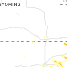
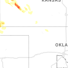
Colorado
| Local Time | Report Details |
|---|---|
| 1:48 PM MDT | Quarter sized hail reported near Divide, CO, 55.3 miles NNW of Pueblo, CO |
| 2:08 PM MDT | Quarter sized hail reported near Elizabeth, CO, 30.2 miles SE of Denver, CO, report from mping: quarter (1.00 in.). |
| 2:13 PM MDT | Quarter sized hail reported near Elizabeth, CO, 32 miles SE of Denver, CO, spotter: e561. |
| 2:14 PM MDT | Quarter sized hail reported near Colorado Springs, CO, 46.5 miles NNW of Pueblo, CO |
| 2:19 PM MDT | Ping Pong Ball sized hail reported near Cascade, CO, 45 miles NNW of Pueblo, CO |
| 2:24 PM MDT | Golf Ball sized hail reported near Colorado Springs, CO, 43.6 miles NNW of Pueblo, CO, report from mping: golf ball (1.75 in.). |
| 2:25 PM MDT | Half Dollar sized hail reported near Colorado Springs, CO, 42.6 miles NNW of Pueblo, CO |
| 2:26 PM MDT | Quarter sized hail reported near Colorado Springs, CO, 42.5 miles NNW of Pueblo, CO |
| 2:28 PM MDT | Tennis Ball sized hail reported near Colorado Springs, CO, 43.4 miles NNW of Pueblo, CO |
| 2:35 PM MDT | Quarter sized hail reported near Colorado Springs, CO, 40.8 miles NNW of Pueblo, CO, report from mping: quarter (1.00 in.). |
| 2:37 PM MDT | Quarter sized hail reported near Colorado Springs, CO, 40.9 miles N of Pueblo, CO |
| 2:38 PM MDT | Ping Pong Ball sized hail reported near Colorado Springs, CO, 40.8 miles NNW of Pueblo, CO, report from mping: ping pong ball (1.50 in.). |
| 2:43 PM MDT | Half Dollar sized hail reported near Colorado Springs, CO, 39.9 miles N of Pueblo, CO, report from mping: half dollar (1.25 in.). |
| 2:45 PM MDT | Ping Pong Ball sized hail reported near Colorado Springs, CO, 40 miles N of Pueblo, CO |
| 2:50 PM MDT | Golf Ball sized hail reported near Kiowa, CO, 43.2 miles SE of Denver, CO |
| 3:12 PM MDT | Quarter sized hail reported near Elizabeth, CO, 31.4 miles SE of Denver, CO, time estimated by radar. |
| 3:24 PM MDT | Golf Ball sized hail reported near Simla, CO, 64 miles SE of Denver, CO |
| 3:43 PM MDT | Golf Ball sized hail reported near Simla, CO, 63.5 miles SE of Denver, CO |
| 3:45 PM MDT | Hen Egg sized hail reported near Yoder, CO, 39.8 miles NE of Pueblo, CO, 2.25 inch hail. |
| 3:52 PM MDT | Quarter sized hail reported near Yoder, CO, 42 miles NE of Pueblo, CO, report from mping: quarter (1.00 in.). |
| 3:56 PM MDT | Half Dollar sized hail reported near Yoder, CO, 37.9 miles NE of Pueblo, CO |
| 4:10 PM MDT | Quarter sized hail reported near Littleton, CO, 9 miles SSW of Denver, CO, report from mping: quarter (1.00 in.). |
| 4:11 PM MDT | Quarter sized hail reported near Littleton, CO, 9 miles SSW of Denver, CO, report from mping: quarter (1.00 in.). |
| 4:17 PM MDT | Quarter sized hail reported near Littleton, CO, 8.2 miles SSW of Denver, CO, report from mping: quarter (1.00 in.). |
| 4:17 PM MDT | Half Dollar sized hail reported near Canon City, CO, 32.7 miles WNW of Pueblo, CO |
| 4:23 PM MDT | Hen Egg sized hail reported near Rush, CO, 44.3 miles NE of Pueblo, CO, windows broken at house. |
| 4:29 PM MDT | Quarter sized hail reported near Penrose, CO, 25.1 miles WNW of Pueblo, CO, report from mping: quarter (1.00 in.). |
| 4:30 PM MDT | Half Dollar sized hail reported near Penrose, CO, 25.1 miles WNW of Pueblo, CO, report from mping: half dollar (1.25 in.). |
| 4:37 PM MDT | Ping Pong Ball sized hail reported near Penrose, CO, 25.1 miles WNW of Pueblo, CO, report from mping: ping pong ball (1.50 in.). |
| 4:42 PM MDT | Golf Ball sized hail reported near Fowler, CO, 35.1 miles ESE of Pueblo, CO, relayed via social media. |
| 4:45 PM MDT | Quarter sized hail reported near Manzanola, CO, 44.3 miles ESE of Pueblo, CO |
| 4:48 PM MDT | Quarter sized hail reported near Olney Springs, CO, 37.5 miles E of Pueblo, CO |
| 6:09 PM MDT | Quarter sized hail reported near Ordway, CO, 46.9 miles E of Pueblo, CO, report from mping: quarter (1.00 in.). |
| 6:18 PM MDT | Storm damage reported in bent county CO, 77.2 miles E of Pueblo, CO |
Georgia
| Local Time | Report Details |
|---|---|
| 3:51 PM EDT | Tree down at mm 11 on hwy 51 in fannin county GA, 63.3 miles E of Chattanooga, TN |
| 4:31 PM EDT | Multiple trees reported down at potts road and mountain pisgah road with an additional 6 trees reported down across roadways throughout catoosa count in catoosa county GA, 15.8 miles SSE of Chattanooga, TN |
| 4:55 PM EDT | Awos station kdnn dalto in whitfield county GA, 33.6 miles SE of Chattanooga, TN |
| 4:56 PM EDT | Widespread downed trees reported county wid in gilmer county GA, 46 miles SE of Chattanooga, TN |
| 5:00 PM EDT | Exterior wall of a firehouse gym collapsed on curtis parkwa in gordon county GA, 43.4 miles SSE of Chattanooga, TN |
| 5:00 PM EDT | Trees down at intersection of hwy 52 and glade farm roa in hall county GA, 60.9 miles NE of Atlanta, GA |
| 5:10 PM EDT | Trees down at dean mill road and carver mill roa in pickens county GA, 52.4 miles NNW of Atlanta, GA |
| 5:21 PM EDT | Multiple trees downed on lower bethany road between worley road and breedlove roa in cherokee county GA, 39.6 miles N of Atlanta, GA |
| 5:27 PM EDT | Approximately 500 trees down across pickens county with county wide power outages. damage has affected roughly 60 roads and a few homes damage in pickens county GA, 50.5 miles N of Atlanta, GA |
| 5:29 PM EDT | 17 reports of trees and/or powerlines down on homes across cherokee count in cherokee county GA, 41.7 miles N of Atlanta, GA |
| 5:32 PM EDT | Several medium sized trees downed at the intersection of bear cub ridge and sanderlin mountain driv in dawson county GA, 50.7 miles N of Atlanta, GA |
| 5:35 PM EDT | 60 mph wind gust reported at awos station kcni canton in cherokee count in cherokee county GA, 39.4 miles N of Atlanta, GA |
| 5:38 PM EDT | Report of numerous trees with their tops sheared off in the fields pond neighborhood in n forsyth count in forsyth county GA, 41.8 miles NNE of Atlanta, GA |
| 5:41 PM EDT | Multiple trees and powerlines down throughout the matt community of forsyth count in forsyth county GA, 39.6 miles NNE of Atlanta, GA |
| 5:44 PM EDT | Trees down near hwy 20 and univeter roa in cherokee county GA, 32.8 miles NNW of Atlanta, GA |
| 5:50 PM EDT | 65 mph gust reported from mesonet station 0637w 2.2 ne cumming (weatherstem in forsyth county GA, 36.3 miles NNE of Atlanta, GA |
| 5:50 PM EDT | Corrects previous non-tstm wnd gst report from 2 ene cumming. 59 mph wind gust reported at mesonet station 1076w 1.6 ne cumming (weatherstem in forsyth county GA, 36 miles NNE of Atlanta, GA |
| 5:50 PM EDT | Tree blocking entire street between freemanville road and nix roa in fulton county GA, 28.7 miles N of Atlanta, GA |
| 5:55 PM EDT | Reports on social media show a large carport/awning was sheared and collapsed off the side of a building along browns bridge r in forsyth county GA, 40.6 miles NNE of Atlanta, GA |
| 6:00 PM EDT | Multiple trees down on mcever road near the intersection of lights ferry roa in hall county GA, 40.5 miles NE of Atlanta, GA |
| 6:00 PM EDT | Reports of 50 to 60 trees down including 1 tree down on a home and 1535 power outages across dawson count in dawson county GA, 49.3 miles NNE of Atlanta, GA |
| 6:00 PM EDT | Mesonet station 1914w forsyth public safety comple in forsyth county GA, 39.9 miles NNE of Atlanta, GA |
| 6:00 PM EDT | Multiple trees down across flowery branc in hall county GA, 40.7 miles NE of Atlanta, GA |
| 6:00 PM EDT | Trees down on helens drive near kelly bridge roa in dawson county GA, 45.1 miles N of Atlanta, GA |
| 6:07 PM EDT | Tree down at hog mountain rd and ridgemill terrac in gwinnett county GA, 34.6 miles NE of Atlanta, GA |
| 6:16 PM EDT | 40 to 50 trees down with power outages across hall count in hall county GA, 48.3 miles NE of Atlanta, GA |
| 6:22 PM EDT | Multiple trees down within the city of loganvill in walton county GA, 29 miles ENE of Atlanta, GA |
| 6:27 PM EDT | Tree down on home along gratis roa in walton county GA, 43 miles ENE of Atlanta, GA |
| 6:33 PM EDT | Multiple trees and powerlines down within the city of monro in walton county GA, 39.3 miles E of Atlanta, GA |
| 6:35 PM EDT | One tree down along jack creek road and mt en in walton county GA, 45.5 miles E of Atlanta, GA |
| 6:42 PM EDT | Tree down on home on gratis road between hale place road and shoal creek roa in walton county GA, 42.5 miles ENE of Atlanta, GA |
| 6:42 PM EDT | Tree down on wall road near monroe. additional reports of several trees down in walton count in walton county GA, 41.9 miles E of Atlanta, GA |
| 6:45 PM EDT | At least 23 reports of trees down across jackson count in jackson county GA, 53.7 miles ENE of Atlanta, GA |
| 6:45 PM EDT | One tree down along thurman baccus roa in walton county GA, 40.5 miles E of Atlanta, GA |
| 6:50 PM EDT | Mesonet station 0761w 0.6 se athens (weatherstem in clarke county GA, 60.3 miles ENE of Atlanta, GA |
| 6:54 PM EDT | Asos station kahn athen in clarke county GA, 62.6 miles ENE of Atlanta, GA |
| 6:56 PM EDT | Reports of widespread down trees across murray count in murray county GA, 36.4 miles ESE of Chattanooga, TN |
| 7:16 PM EDT | Reports of 22 trees down and power outages across henry count in henry county GA, 26.3 miles SE of Atlanta, GA |
| 7:30 PM EDT | Awos station kiiy washingto in wilkes county GA, 52.9 miles WNW of Augusta, GA |
| 7:38 PM EDT | Corrects previous tstm wnd dmg report from 15 nnw lincolnton. lincoln co em reported two homes with trees fallen into roof near broad river scenic drive. time estimated in lincoln county GA, 50.7 miles NW of Augusta, GA |
| 7:45 PM EDT | Lincoln county emergency manager reported trees down in lincolnton. time estimated by rada in lincoln county GA, 36.1 miles NW of Augusta, GA |
| 7:48 PM EDT | Lincoln county emergency manager reported around a dozen trees down within a 2 mile radius of lincolnton. time estimated by rada in lincoln county GA, 35.2 miles NW of Augusta, GA |
| 7:53 PM EDT | Multiple trees down along highway 78 from near arnoldsville to the clarke county lin in oglethorpe county GA, 67 miles E of Atlanta, GA |
| 7:57 PM EDT | Lincoln co em reported multiple trees down in elijah state park. time estimate in lincoln county GA, 35.4 miles NW of Augusta, GA |
| 7:59 PM EDT | Corrects previous tstm wnd dmg report from norwood. trees down in the 1000-4000 blocks of ridge road in norwoo in warren county GA, 42.5 miles W of Augusta, GA |
| 8:00 PM EDT | 5 trees down on roadways in cama in warren county GA, 39 miles W of Augusta, GA |
| 8:00 PM EDT | Trained spotter reported multiple downed trees on hwy 47 just south of strom thurmond lake. time estimated by rada in columbia county GA, 24.7 miles NW of Augusta, GA |
| 8:00 PM EDT | Mcduffie dispatch reported widespread trees down across the county. time estimated by rada in mcduffie county GA, 29.2 miles W of Augusta, GA |
| 8:00 PM EDT | Public report of part of a roof blown of a boat shed on strom thurmond lake and multiple trees down in neighborhood. time estimated by rada in lincoln county GA, 29.8 miles WNW of Augusta, GA |
| 8:07 PM EDT | 4 trees down across roadways in warrento in warren county GA, 39.8 miles W of Augusta, GA |
| 8:25 PM EDT | Richmond dispatch reported widespread trees and powerlines downed across the county. time estimated by rada in richmond county GA, 2.2 miles SSW of Augusta, GA |
| 8:39 PM EDT | Burke dispatch reported trees down on blount chapel rd near drone rd. time estimated by rada in burke county GA, 31.6 miles SSW of Augusta, GA |
| 8:47 PM EDT | Burke dispatch reported trees down on saxon rd near hwy 56. time estimated by rada in burke county GA, 19.9 miles S of Augusta, GA |
| 8:57 PM EDT | Burke dispatch reported trees down on clark place rd near hwy 24. time estimated by rada in burke county GA, 28.2 miles S of Augusta, GA |
| 9:16 PM EDT | Multiple trees down at watson road and watson farms lan in forsyth county GA, 35.8 miles NNE of Atlanta, GA |
| 9:23 PM EDT | Tree reported down along the 1700 block of waynesboro highway. time estimated from rada in screven county GA, 46.3 miles SSE of Augusta, GA |
| 9:34 PM EDT | Tree reported down along waters station road. time estimated from rada in screven county GA, 54.8 miles SSE of Augusta, GA |
| 9:47 PM EDT | Tree reported down along north trapnell street near washington street. time estimated from rada in candler county GA, 60.3 miles WNW of Savannah, GA |
| 10:53 PM EDT | Trees down in the 1000-4000 blocks of ridge road in norwoo in warren county GA, 42.5 miles W of Augusta, GA |
| 11:25 PM EDT | Observation from the savannah entrance light reported a wind gust of 34 knots or 39 mp in amz352 county GA, 17.2 miles ESE of Savannah, GA |
Kansas
| Local Time | Report Details |
|---|---|
| 3:00 PM CDT | Reports of damage to irrigation equipment and shed in wichita county KS, 52 miles NNW of Garden City, KS |
| 3:00 PM CDT | Tennis Ball sized hail reported near Leoti, KS, 55 miles SSW of Colby, KS, window damage to home also reported. |
| 3:43 PM CDT | Tennis Ball sized hail reported near Scott City, KS, 39.6 miles NNW of Garden City, KS |
| 3:45 PM CDT | Golf Ball sized hail reported near Marienthal, KS, 37.6 miles NNW of Garden City, KS, facebook messenger. |
| 4:10 PM CDT | A dozen power poles down around the intersection of kansas rd and finney scott rd due to possible tornad in finney county KS, 20.9 miles N of Garden City, KS |
| 4:15 PM CDT | Several power poles down at this location. image of this damage also showed hail-covered field with hail fo in finney county KS, 15.2 miles N of Garden City, KS |
| 4:15 PM CDT | Picture of flipped center pivot at this location on gano rd... about a mile east of highway 83 where power poles were down. there was extensive wind and hail damage to in finney county KS, 15.3 miles N of Garden City, KS |
| 4:20 PM CDT | A home lost some shingles and some flying debris struck a propane tank causing a gas lea in finney county KS, 10.1 miles NNE of Garden City, KS |
| 4:30 PM CDT | Quarter sized hail reported near Leoti, KS, 34.1 miles NW of Garden City, KS |
| 4:48 PM CDT | Tennis Ball sized hail reported near Garden City, KS, 10.9 miles NE of Garden City, KS |
| 5:00 PM CDT | Asos station kgck garden cit in finney county KS, 9 miles ESE of Garden City, KS |
| 5:25 PM CDT | Storm damage reported in gray county KS, 23.5 miles E of Garden City, KS |
| 5:36 PM CDT | Half Dollar sized hail reported near Ingalls, KS, 25.8 miles ESE of Garden City, KS, report from mping: half dollar (1.25 in.). |
| 6:05 PM CDT | Storm damage reported in ford county KS, 47.2 miles ESE of Garden City, KS |
| 6:26 PM CDT | Asos station kddc dodge city regional airpor in ford county KS, 51.2 miles ESE of Garden City, KS |
| 8:40 PM MDT | Mesonet station kwlk1 wallace. wind gust measured at 2 meter height. wind direction from the north-northeas in wallace county KS, 58.8 miles SW of Colby, KS |
| 9:11 PM MDT | Tribune awos reported at wind gust of 64 mph at 911 pm md in greeley county KS, 58.1 miles NW of Garden City, KS |
| 9:14 PM MDT | Storm damage reported in greeley county KS, 56.2 miles WNW of Garden City, KS |
| 9:18 PM MDT | Storm damage reported in greeley county KS, 54.6 miles NW of Garden City, KS |
| 9:22 PM MDT | The awos in tribune (k5k2) measured a 71 mph (62 knot) wind gust at 0322 ut in greeley county KS, 59.8 miles NW of Garden City, KS |
| 9:25 PM MDT | Corrects previous tstm wnd dmg report from tribune. delayed report of railroad crossing arm broken off at main street in tribune. time is estimated using radar and near in greeley county KS, 58.9 miles NW of Garden City, KS |
| 11:15 PM CDT | Mesonet station lkuk1 laki in kearny county KS, 20.3 miles WSW of Garden City, KS |
| 11:55 PM CDT | Awos station khqg hugoto in stevens county KS, 61.5 miles SSW of Garden City, KS |
| 11:20 PM MDT | Delayed report of railroad crossing arm broken off at main street in tribun in greeley county KS, 58.9 miles NW of Garden City, KS |
| 12:25 AM CDT | Storm damage reported in seward county KS, 64.2 miles S of Garden City, KS |
| 12:31 AM CDT | Awos station klbl libera in seward county KS, 65 miles S of Garden City, KS |
| 12:45 AM CDT | Mesonet station dw9907 bloo in ford county KS, 59.9 miles ESE of Garden City, KS |
| 12:55 AM CDT | Mesonet station up835 3.0 w kingsdown (upr in ford county KS, 66.3 miles ESE of Garden City, KS |
Ohio
| Local Time | Report Details |
|---|---|
| 4:57 PM EDT | Half Dollar sized hail reported near Montpelier, OH, 46.8 miles NNE of Fort Wayne, IN, report from mping: half dollar (1.25 in.). |
| 5:07 PM EDT | Large tree down in kunkle. time estimated via rada in williams county OH, 49.9 miles NE of Fort Wayne, IN |
| 5:39 PM EDT | Quarter sized hail reported near Oak Harbor, OH, 73.9 miles W of Cleveland, OH, report from mping: quarter (1.00 in.) hail. |
| 5:40 PM EDT | Half Dollar sized hail reported near Oak Harbor, OH, 73.9 miles W of Cleveland, OH, report from mping: half dollar (1.25 in.) hail. |
| 5:45 PM EDT | 30 foot tall tree down on a house at catawba poin in ottawa county OH, 59.9 miles W of Cleveland, OH |
| 6:05 PM EDT | Trees down. time estimated from rada in auglaize county OH, 52.7 miles SE of Fort Wayne, IN |
| 6:17 PM EDT | Tree limb and power line downed. time estimated via rada in wood county OH, 88 miles ENE of Fort Wayne, IN |
| 6:18 PM EDT | Power pole snapped and hit a car... large tree branch on wires near the yacht club and large tree uproote in lake county OH, 22.7 miles NE of Cleveland, OH |
| 6:18 PM EDT | Buoy station faio1 fairport... o in lake county OH, 27.6 miles NE of Cleveland, OH |
| 6:18 PM EDT | Asos station ktdz toled in wood county OH, 90.9 miles ENE of Fort Wayne, IN |
| 6:24 PM EDT | Corrects previous tstm wnd dmg report from ohio city to update number of injuries. emergency manager reports tree down on a house in ohio city in van wert county. two p in van wert county OH, 32.8 miles SE of Fort Wayne, IN |
| 6:27 PM EDT | Widespread tree damage in fairport harbor. time estimated via rada in lake county OH, 27.6 miles NE of Cleveland, OH |
| 6:30 PM EDT | Buoy station faio1 fairport... o in lake county OH, 27.6 miles NE of Cleveland, OH |
| 6:30 PM EDT | Half Dollar sized hail reported near Harrod, OH, 66.7 miles ESE of Fort Wayne, IN |
| 6:30 PM EDT | Trees down. time estimated from rada in mercer county OH, 32.3 miles SSE of Fort Wayne, IN |
| 6:31 PM EDT | Tree down on house. time estimated from rada in lorain county OH, 25.7 miles W of Cleveland, OH |
| 6:33 PM EDT | Half Dollar sized hail reported near Ohio City, OH, 34 miles SE of Fort Wayne, IN, report from mping: half dollar (1.25 in.). |
| 6:39 PM EDT | Trees down. time estimated from rada in hardin county OH, 69.9 miles ESE of Fort Wayne, IN |
| 6:40 PM EDT | Tree down on house on auburn r in geauga county OH, 24.1 miles ENE of Cleveland, OH |
| 6:42 PM EDT | Large branch down. time estimated from rada in shelby county OH, 64.5 miles WNW of Columbus, OH |
| 6:43 PM EDT | Tree down on north main street in rockfor in mercer county OH, 35 miles SE of Fort Wayne, IN |
| 6:45 PM EDT | Emergency manager reports numerous trees down between wren... oh and ohio city... o in van wert county OH, 28.7 miles SE of Fort Wayne, IN |
| 6:46 PM EDT | A few tree limbs down on jefferson stree in van wert county OH, 30.6 miles ESE of Fort Wayne, IN |
| 6:50 PM EDT | Quarter sized hail reported near Ada, OH, 68.4 miles NW of Columbus, OH, report from mping: quarter (1.00 in.). |
| 6:52 PM EDT | Two trees down on a house. time estimated from rada in lorain county OH, 16 miles WSW of Cleveland, OH |
| 6:54 PM EDT | Ping Pong Ball sized hail reported near Ada, OH, 69.1 miles ESE of Fort Wayne, IN, social media photo of measured hail stones. |
| 6:56 PM EDT | Quarter sized hail reported near Avon, OH, 17.5 miles WSW of Cleveland, OH |
| 6:57 PM EDT | Quarter sized hail reported near Lakeview, OH, 61.5 miles NW of Columbus, OH, report from mping: quarter (1.00 in.). |
| 7:00 PM EDT | Ping Pong Ball sized hail reported near Lakeview, OH, 60.7 miles NW of Columbus, OH, report forwarded via social media. |
| 7:04 PM EDT | Quarter sized hail reported near North Olmsted, OH, 14.2 miles WSW of Cleveland, OH, report from mping: quarter (1.00 in.) hail. |
| 7:05 PM EDT | Quarter sized hail reported near Westlake, OH, 13.2 miles W of Cleveland, OH, report from mping: quarter (1.00 in.) hail. |
| 7:05 PM EDT | Hen Egg sized hail reported near Westlake, OH, 13 miles WSW of Cleveland, OH |
| 7:05 PM EDT | Two trees down in north olmste in cuyahoga county OH, 13.6 miles WSW of Cleveland, OH |
| 7:11 PM EDT | Large tree branch snapped at lakewood par in cuyahoga county OH, 5.8 miles W of Cleveland, OH |
| 7:18 PM EDT | Golf Ball sized hail reported near Cleveland, OH, 9.1 miles SSW of Cleveland, OH, quarter to golf ball-sized hail in parma and parma heights. |
| 7:18 PM EDT | Mesonet station xcle cleveland - edgewate in lez146 county OH, 2.1 miles W of Cleveland, OH |
| 7:20 PM EDT | Large tree branch on west 54t in cuyahoga county OH, 7.4 miles SSW of Cleveland, OH |
| 7:20 PM EDT | Ping Pong Ball sized hail reported near Cleveland, OH, 7 miles SSW of Cleveland, OH, retired nws employee reports 1 and a half inch hail in parma. |
| 7:22 PM EDT | Large tree limb down 4 miles northwest of mantua. time estimated via rada in portage county OH, 24.8 miles ESE of Cleveland, OH |
| 7:25 PM EDT | Ping Pong Ball sized hail reported near Independence, OH, 7.9 miles S of Cleveland, OH, 1.5 inch hail. |
| 7:26 PM EDT | Quarter sized hail reported near Independence, OH, 6.7 miles SSE of Cleveland, OH, nickel to quarter sized hail at nws cleveland office. |
| 7:27 PM EDT | Trees and power lines down. time estimated from rada in logan county OH, 45.7 miles WNW of Columbus, OH |
| 7:27 PM EDT | Tree downed. time estimated via rada in seneca county OH, 75.2 miles NNW of Columbus, OH |
| 7:34 PM EDT | Large section of tree downed on n center street. one power pole broken. time estimated from rada in logan county OH, 54.7 miles NW of Columbus, OH |
| 7:40 PM EDT | Quarter sized hail reported near Cleveland, OH, 9.3 miles S of Cleveland, OH, corrects previous hail report from 1 ese parma. |
| 7:40 PM EDT | Half Dollar sized hail reported near Bedford, OH, 10.4 miles SE of Cleveland, OH, report from mping: half dollar (1.25 in.). |
| 7:41 PM EDT | A few downed trees and power outages reported in the new london area. time estimated via rada in huron county OH, 46.7 miles SW of Cleveland, OH |
| 7:45 PM EDT | Ping Pong Ball sized hail reported near Independence, OH, 8.6 miles S of Cleveland, OH, report from mping: ping pong ball (1.50 in.). |
| 7:49 PM EDT | Quarter sized hail reported near Cleveland, OH, 9.3 miles S of Cleveland, OH |
| 7:49 PM EDT | Two trees downed across road near bloomville. time estimated via rada in seneca county OH, 75.1 miles N of Columbus, OH |
| 7:50 PM EDT | Tree downed onto road in brunswick. time estimated via rada in medina county OH, 19.4 miles SSW of Cleveland, OH |
| 7:50 PM EDT | Reports of several trees down across howland townshi in trumbull county OH, 53.2 miles ESE of Cleveland, OH |
| 7:50 PM EDT | Tree down onto park ledge driv in summit county OH, 15.9 miles SE of Cleveland, OH |
| 7:54 PM EDT | Multiple trees down. time estimated from rada in union county OH, 36.5 miles NW of Columbus, OH |
| 7:55 PM EDT | Tree down. time estimated from rada in darke county OH, 61.3 miles SSE of Fort Wayne, IN |
| 7:58 PM EDT | Tree down on boneta rd between route 18 and ridgewoo in medina county OH, 26.3 miles S of Cleveland, OH |
| 8:00 PM EDT | Several trees/wires down across liberty townshi in trumbull county OH, 58.8 miles ESE of Cleveland, OH |
| 8:02 PM EDT | Tree down on yellow creek rd near sand run r in summit county OH, 24.3 miles SSE of Cleveland, OH |
| 8:07 PM EDT | A few trees and wires downed onto roadways between nova and nankin. time estimated via rada in ashland county OH, 47.8 miles SW of Cleveland, OH |
| 8:07 PM EDT | A few trees and wires downed onto roadways between nova and nankin. time estimated via rada in ashland county OH, 48 miles SW of Cleveland, OH |
| 8:08 PM EDT | Trees down countywide. time estimated from rada in delaware county OH, 23.6 miles N of Columbus, OH |
| 8:21 PM EDT | Three cars submerged in water at w117 and berea r in cuyahoga county OH, 4.8 miles WSW of Cleveland, OH |
| 8:38 PM EDT | Trees down along u.s. 23 in delawar in delaware county OH, 23.6 miles N of Columbus, OH |
| 8:38 PM EDT | Tree limb downed onto road in the mechanicsburg/wayne twp area. a few other wires reported downed in the county. time estimated via rada in wayne county OH, 46.5 miles SSW of Cleveland, OH |
| 8:40 PM EDT | Several trees down and blocking roads in new frankli in summit county OH, 39 miles S of Cleveland, OH |
| 8:47 PM EDT | Trees down and telephone poles snapped. time estimated from rada in miami county OH, 64.5 miles W of Columbus, OH |
| 8:58 PM EDT | Large branch and wires down near fisher and hague roads. time estimated from rada in franklin county OH, 4.1 miles W of Columbus, OH |
| 9:00 PM EDT | Scattered tree damage across knox county... especially western and southwestern portions of the county. time estimated via rada in knox county OH, 41 miles NE of Columbus, OH |
| 9:02 PM EDT | Fallen tree onto roof of hous in stark county OH, 47.6 miles SSE of Cleveland, OH |
| 9:07 PM EDT | Trees down. time estimated from rada in clark county OH, 45.5 miles W of Columbus, OH |
| 9:09 PM EDT | Trees down on power lines. time estimated from rada in fayette county OH, 36.2 miles SW of Columbus, OH |
| 9:12 PM EDT | Large branch down. time estimated from rada in franklin county OH, 4 miles NW of Columbus, OH |
| 9:24 PM EDT | Tree down on gamble roa in columbiana county OH, 50.4 miles WNW of Pittsburgh, PA |
| 9:25 PM EDT | Tree down on route 45 and route 55 in columbiana county OH, 50.9 miles WNW of Pittsburgh, PA |
| 9:25 PM EDT | Storm damage reported in clinton county OH, 44.7 miles ENE of Cincinnati, OH |
| 9:26 PM EDT | Trees and wires down. time estimated from rada in licking county OH, 32.7 miles ENE of Columbus, OH |
| 9:38 PM EDT | Tree down on state route 164 and spring valley roa in columbiana county OH, 45.2 miles WNW of Pittsburgh, PA |
| 9:41 PM EDT | Trees down. time estimated from rada in clinton county OH, 47.9 miles ENE of Cincinnati, OH |
| 9:41 PM EDT | Numerous branches on atioch road... trees down. time estimated from rada in clinton county OH, 47.3 miles ENE of Cincinnati, OH |
| 9:45 PM EDT | Tree down on annesley roa in columbiana county OH, 36.2 miles WNW of Pittsburgh, PA |
| 9:55 PM EDT | One large tree downed on w main street. time estimated from rada in highland county OH, 51.9 miles SW of Columbus, OH |
| 10:04 PM EDT | Tree down. time estimated from rada in greene county OH, 43.9 miles WSW of Columbus, OH |
| 10:18 PM EDT | 2 trees down. time estimated from rada in fairfield county OH, 30 miles SE of Columbus, OH |
Alabama
| Local Time | Report Details |
|---|---|
| 4:34 PM CDT | A large tree was reported down along county road 50 near hollywoo in jackson county AL, 39.8 miles WSW of Chattanooga, TN |
| 6:42 PM CDT | A tree was reported down on a home along monte sano blvd and hutchens av in madison county AL, 65.3 miles E of Florence, AL |
| 8:00 PM CDT | Golf Ball sized hail reported near Groveoak, AL, 61 miles SW of Chattanooga, TN, golf ball size hail was reported in grove oak. |
| 8:03 PM CDT | Quarter sized hail reported near Geraldine, AL, 61.9 miles SW of Chattanooga, TN, reports of 1 inch hail in geraldine. |
Idaho
| Local Time | Report Details |
|---|---|
| 3:47 PM MDT | Mesonet station crii1 cotton ridg in cassia county ID, 30 miles SSE of Twin Falls, ID |
| 4:15 PM MDT | Mesonet station junction 33/22 summi in butte county ID, 45.6 miles WNW of Idaho Falls, ID |
| 4:20 PM MDT | Mesonet station san sand dune in butte county ID, 41.1 miles WNW of Idaho Falls, ID |
| 5:45 PM MDT | Itd rwis itd15 idaho fall in bonneville county ID, 1.1 miles WNW of Idaho Falls, ID |
| 7:30 PM MDT | Itd rwis itd23 osborne bridg in fremont county ID, 64.4 miles NNE of Idaho Falls, ID |
Virginia
| Local Time | Report Details |
|---|---|
| 6:37 PM EDT | Tree down. time estimated from rada in roanoke county VA, 5.5 miles NNE of Roanoke, VA |
New York
| Local Time | Report Details |
|---|---|
| 7:11 PM EDT | Telephone pole down across route 2 in chautauqua county NY, 61.2 miles SW of Buffalo, NY |
| 7:12 PM EDT | Tree and wires down in hartfiel in chautauqua county NY, 52.1 miles SW of Buffalo, NY |
| 7:16 PM EDT | Tree down on union stree in chautauqua county NY, 52.6 miles SW of Buffalo, NY |
| 7:17 PM EDT | Tree and wires down on park stree in chautauqua county NY, 44.6 miles SW of Buffalo, NY |
| 7:17 PM EDT | Large tree down across academy stree in chautauqua county NY, 52.3 miles SW of Buffalo, NY |
| 7:24 PM EDT | Tree down on parcell roa in chautauqua county NY, 47.5 miles SW of Buffalo, NY |
| 7:25 PM EDT | Several trees down near route 5 and lake avenu in chautauqua county NY, 43 miles SW of Buffalo, NY |
| 7:25 PM EDT | Tree and wires down on cassadaga roa in chautauqua county NY, 42.1 miles SSW of Buffalo, NY |
| 7:26 PM EDT | Tree down onto house on west shorewood driv in chautauqua county NY, 39.3 miles SW of Buffalo, NY |
| 7:26 PM EDT | Large tree down across lake avenue. additional trees down on lake avenu in chautauqua county NY, 43.5 miles SW of Buffalo, NY |
| 7:35 PM EDT | Tree down blocking both directions of bates roa in chautauqua county NY, 46.1 miles SSW of Buffalo, NY |
| 7:35 PM EDT | Large tree and wires down on maple av in chautauqua county NY, 42 miles SSW of Buffalo, NY |
| 7:37 PM EDT | Reports of multiple trees down in bran in erie county NY, 21.8 miles SSW of Buffalo, NY |
| 7:37 PM EDT | Reports of multiple trees down in farnha in erie county NY, 22.8 miles SSW of Buffalo, NY |
| 7:38 PM EDT | Several trees and wires down across town in south dayto in cattaraugus county NY, 37.3 miles SSW of Buffalo, NY |
| 7:40 PM EDT | Several trees down in dayto in cattaraugus county NY, 32.5 miles S of Buffalo, NY |
| 7:41 PM EDT | Tree down on markhams roa in cattaraugus county NY, 35.8 miles S of Buffalo, NY |
| 7:43 PM EDT | Tree down on a house and ca in cattaraugus county NY, 29.5 miles S of Buffalo, NY |
| 7:43 PM EDT | Reports of multiple trees down in angol in erie county NY, 18.6 miles SSW of Buffalo, NY |
| 7:44 PM EDT | Tree down in perrysbur in cattaraugus county NY, 30 miles SSW of Buffalo, NY |
| 7:46 PM EDT | Reports of multiple trees down in the town of evan in erie county NY, 16.9 miles SSW of Buffalo, NY |
| 7:46 PM EDT | Tree down on home on lake shore road in the town of evan in erie county NY, 14 miles SSW of Buffalo, NY |
| 7:46 PM EDT | Tree down in youngstown on vehicle and hom in niagara county NY, 26.5 miles NNW of Buffalo, NY |
| 7:54 PM EDT | Tree down across the intersection of nelson & beebe roads in wilso in niagara county NY, 26.5 miles NNE of Buffalo, NY |
| 7:55 PM EDT | Tree down on belknap rd in ede in erie county NY, 13.5 miles S of Buffalo, NY |
| 7:57 PM EDT | Tree down across broadway roa in cattaraugus county NY, 30.2 miles S of Buffalo, NY |
| 7:58 PM EDT | Tree down across route 35 in cattaraugus county NY, 36.3 miles S of Buffalo, NY |
| 7:58 PM EDT | Tree down on gowanda zoar roa in erie county NY, 29.4 miles S of Buffalo, NY |
| 7:59 PM EDT | Power poles broken and 3-inch tree limbs broke in erie county NY, 14 miles SSW of Buffalo, NY |
| 8:00 PM EDT | Tree down across reed hill roa in cattaraugus county NY, 37.5 miles S of Buffalo, NY |
| 8:07 PM EDT | Tree down on doat street near poplar av in erie county NY, 4.3 miles ENE of Buffalo, NY |
| 8:08 PM EDT | Tree down at mile marker 61.3 blocking traffic on i-86 just east of salamanc in cattaraugus county NY, 51.7 miles S of Buffalo, NY |
| 8:13 PM EDT | Tree down on maple street in yorkshir in cattaraugus county NY, 31.8 miles SE of Buffalo, NY |
| 8:15 PM EDT | Tree down across delevan road (route 21 in cattaraugus county NY, 34.3 miles SE of Buffalo, NY |
| 8:15 PM EDT | Several trees dow in cattaraugus county NY, 32.4 miles SE of Buffalo, NY |
| 8:19 PM EDT | Tree down in the village of franklinvill in cattaraugus county NY, 43.5 miles SSE of Buffalo, NY |
| 8:20 PM EDT | Trees dow in wyoming county NY, 33.5 miles SE of Buffalo, NY |
| 8:26 PM EDT | Multiple trees down on 4 mile roa in cattaraugus county NY, 60.3 miles SSE of Buffalo, NY |
| 8:28 PM EDT | Trees down in the town of eagl in wyoming county NY, 37.5 miles SE of Buffalo, NY |
| 8:33 PM EDT | Tree down across olean portville roa in cattaraugus county NY, 63.5 miles SSE of Buffalo, NY |
| 8:34 PM EDT | Tree down on route 44 in allegany county NY, 55.2 miles SSE of Buffalo, NY |
| 8:46 PM EDT | Tree down in alexande in genesee county NY, 31.4 miles E of Buffalo, NY |
| 9:09 PM EDT | Trees down partially blocking county rt 70a in north hornel in steuben county NY, 72.3 miles ESE of Buffalo, NY |
| 9:11 PM EDT | Trees down reported near i-86 and county rte 2 in steuben county NY, 71.7 miles ESE of Buffalo, NY |
| 9:18 PM EDT | Power lines down in the village of avon... including at north ave. and main s in livingston county NY, 57.8 miles E of Buffalo, NY |
| 9:28 PM EDT | Tree down crossing manitou rd and shepard rd intersectio in monroe county NY, 60.2 miles ENE of Buffalo, NY |
| 9:39 PM EDT | Tree dow in ontario county NY, 70.2 miles WSW of Syracuse, NY |
| 9:40 PM EDT | Tree down on golf ave near marsh rd intersectio in monroe county NY, 67.5 miles W of Syracuse, NY |
| 9:43 PM EDT | Trees down near county rt 14 in bath... n in steuben county NY, 77.2 miles SW of Syracuse, NY |
| 10:00 PM EDT | Wires down in campbell... n in steuben county NY, 77.3 miles SW of Syracuse, NY |
| 10:05 PM EDT | Power lines dow in ontario county NY, 55.1 miles W of Syracuse, NY |
South Carolina
| Local Time | Report Details |
|---|---|
| 8:00 PM EDT | Mccormick county emergency manager reported widespread trees down across the count in mccormick county SC, 34.5 miles NNW of Augusta, GA |
| 8:15 PM EDT | Tree down on bill jones rd in horry county SC, 71.9 miles NE of Charleston, SC |
| 8:16 PM EDT | Horry county 911 center reported a tree down on william nobles road near aynor... sc. call came in around 830 pm... but time of event estimated via radar as 816 p in horry county SC, 72 miles NE of Charleston, SC |
| 8:25 PM EDT | Edgefield dispatch reported widespread trees and powerlines downed across the county. time estimated by rada in edgefield county SC, 21.6 miles N of Augusta, GA |
| 8:27 PM EDT | A large tree downed and blocked the road on river north dr. near gordon hwy. time estimated by rada in aiken county SC, 1.5 miles E of Augusta, GA |
| 8:42 PM EDT | Aiken dispatch reported widespread trees and powerlines down across the county. time estimated by rada in aiken county SC, 16.8 miles ENE of Augusta, GA |
| 9:07 PM EDT | Barnwell county dispatch reported numerous trees down in the williston area. time estimated by rada in barnwell county SC, 33.1 miles E of Augusta, GA |
| 9:18 PM EDT | Barnwell county dispatch reported numerous trees down in the blackville area. time estimated by rada in barnwell county SC, 41.6 miles E of Augusta, GA |
| 9:45 PM EDT | Spotter reported north rd (us178) near deer crossing road completely blocked due to a large tree in the road. time estimate in orangeburg county SC, 59.4 miles E of Augusta, GA |
| 10:02 PM EDT | Tree reported down along bells highway at confederate highway. time estimated from rada in colleton county SC, 55 miles WSW of Charleston, SC |
| 10:07 PM EDT | Social media user reported down trees along interstate 26 and some side roads in orangeburg county near bowman. time estimate in orangeburg county SC, 40.6 miles WNW of Charleston, SC |
| 10:12 PM EDT | Williamsburg call center reported a tree down at rhodus avenue and santee road near andrews... s in williamsburg county SC, 23.3 miles ENE of Charleston, SC |
| 10:15 PM EDT | Report of a large limb down along sc-402 at rectory hill road. time estimated from rada in berkeley county SC, 3.7 miles E of Charleston, SC |
| 10:24 PM EDT | Tree reported down along highway 15 at cherry lane. time estimated from rada in dorchester county SC, 30.1 miles W of Charleston, SC |
| 10:33 PM EDT | Tree reported down along the 22000 block of augusta highway. time estimated from rada in colleton county SC, 28.4 miles WSW of Charleston, SC |
| 10:33 PM EDT | Multiple trees reported down between the 4200 and the 6000 blocks of charleston highway. time estimated from rada in colleton county SC, 41.3 miles WSW of Charleston, SC |
| 10:33 PM EDT | Multiple trees reported down between the 4200 and the 6000 blocks of charleston highway. time estimated from rada in colleton county SC, 41.3 miles WSW of Charleston, SC |
| 10:35 PM EDT | Tree blocking lane near the intersection of round-o road and wesley grove road. time estimated by rada in colleton county SC, 34.6 miles WSW of Charleston, SC |
| 10:40 PM EDT | Power lines reported down along zion road at wire road. time estimated from rada in dorchester county SC, 26 miles WSW of Charleston, SC |
| 10:50 PM EDT | Trained spotter measured a wind gust of 62 mp in dorchester county SC, 18.1 miles SSW of Charleston, SC |
North Carolina
| Local Time | Report Details |
|---|---|
| 10:45 PM EDT | Cwop site fw6543 reported a gust of 64 mp in amz252 county NC, 32.7 miles S of Wilmington, NC |
| 10:45 PM EDT | Frying pan shoals light tower measured a gust to 64 mph at 87 feet hig in amz272 county NC, 55.9 miles SSE of Wilmington, NC |
Arizona
| Local Time | Report Details |
|---|---|
| 8:19 PM MST | Raws station qhpa3 hopkins measured a wind gust of 62 mp in santa cruz county AZ, 37.7 miles S of Tucson, AZ |
Oklahoma
| Local Time | Report Details |
|---|---|
| 12:34 AM CDT | Mobile home sustained roof damage. pictures sent in from emergency manager. time estimated from rada in beaver county OK, 72.7 miles WNW of Woodward, OK |
| 12:35 AM CDT | Measured by oklahoma mesone in texas county OK, 96.2 miles N of Amarillo, TX |
| 12:50 AM CDT | Measured by oklahoma mesone in beaver county OK, 67.8 miles WNW of Woodward, OK |
| 3:45 AM CDT | Storm damage reported in garfield county OK, 63.5 miles NNW of Oklahoma City, OK |
| 3:52 AM CDT | Storm damage reported in garfield county OK, 63.5 miles NNW of Oklahoma City, OK |
| 4:05 AM CDT | Train cars overturned... power poles dow in garfield county OK, 61.4 miles N of Oklahoma City, OK |
| 4:10 AM CDT | Storm damage reported in garfield county OK, 65.4 miles N of Oklahoma City, OK |
| 5:30 AM CDT | Storm damage reported in kay county OK, 60.4 miles SSE of Wichita, KS |
Maryland
| Local Time | Report Details |
|---|---|
| 5:37 AM EDT | Tree down at unionville road and st. michaels roa in talbot county MD, 44 miles SE of Baltimore, MD |
Connect with Interactive Hail Maps