

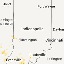
Hail Map for Monday, July 2, 2012

Number of Impacted Households on 7/2/2012
0
Impacted by 1" or Larger Hail
0
Impacted by 1.75" or Larger Hail
0
Impacted by 2.5" or Larger Hail
Square Miles of Populated Area Impacted on 7/2/2012
0
Impacted by 1" or Larger Hail
0
Impacted by 1.75" or Larger Hail
0
Impacted by 2.5" or Larger Hail


Cities Most Affected by Hail Storms of 7/2/2012
| Hail Size | Demographics of Zip Codes Affected | ||||||
|---|---|---|---|---|---|---|---|
| City | Count | Average | Largest | Pop Density | House Value | Income | Age |
| Flint, MI | 1 | 1.75 | 1.75 | 1490 | $76k | $37.5k | 35.5 |
| Tensed, ID | 1 | 1.75 | 1.75 | 3 | $68k | $27.6k | 50.5 |
| Bejou, MN | 1 | 1.75 | 1.75 | 3 | $26k | $32.2k | 45.8 |
| Knoxville, TN | 1 | 1.75 | 1.75 | 1921 | $77k | $31.3k | 33.2 |
| Crandon, WI | 1 | 1.75 | 1.75 | 30 | $82k | $30.8k | 41.0 |
| Grand Blanc, MI | 1 | 1.75 | 1.75 | 965 | $140k | $61.0k | 38.3 |
Hail and Wind Damage Spotted on 7/2/2012
Filter by Report Type:Hail ReportsWind Reports
States Impacted
North Dakota, Alabama, Tennessee, Minnesota, Illinois, Kentucky, Florida, Indiana, Wisconsin, Missouri, Michigan, IdahoNorth Dakota
| Local Time | Report Details |
|---|---|
| 10:15 AM CDT | Quarter sized hail reported near Willow City, ND, 50.2 miles ENE of Minot, ND, late report from monday morning. |
| 1:45 PM CDT | High winds snapped a flagpole in half and stripped sections of siding from the house. numerous branches down of indeterminate siz in pembina county ND, 73.3 miles W of Roseau, MN |
Alabama
| Local Time | Report Details |
|---|---|
| 11:22 AM CDT | Minor roof damage to two homes along oakcrest drive due to fallen tree in perry county AL, 42.6 miles N of Camden, AL |
| 5:00 PM CDT | Tree and powerlines down at hwy 188 and satsuma road. hwy 188 closed at this area due to powerlines dow in mobile county AL, 23.3 miles SSW of Mobile, AL |
Tennessee
| Local Time | Report Details |
|---|---|
| 1:30 PM CDT | Power lines were blown down in davidson county TN, 14.4 miles SW of Nashville, TN |
| 2:30 PM CDT | Steeple and siding was blown off first baptist church in joelton with debris blown into parking lot next door. report via tspotter and facebook with time estimate in davidson county TN, 11.1 miles NNW of Nashville, TN |
| 3:30 PM CDT | Trees and power lines were blown down on highway 48n in pinewood in hickman county TN, 43.4 miles WSW of Nashville, TN |
| 3:40 PM CDT | Trees and fireworks tent blown down. time estimate in marshall county TN, 37.1 miles S of Nashville, TN |
| 4:07 PM CDT | Several trees dow in sequatchie county TN, 22.8 miles NNW of Chattanooga, TN |
| 4:50 PM CDT | Several trees and power lines dow in marion county TN, 18.2 miles W of Chattanooga, TN |
| 5:04 PM CDT | A few trees and a few powerlines blown dow in maury county TN, 50.3 miles SSW of Nashville, TN |
| 5:20 PM CDT | Delayed report. several trees blown down near the bledsoe county line. time estimate in cumberland county TN, 52.2 miles NNE of Chattanooga, TN |
| 6:20 PM CDT | Trees down along woodcliff road in putnam county TN, 78.2 miles N of Chattanooga, TN |
| 9:15 PM EDT | Quarter sized hail reported near Knoxville, TN, 1.8 miles WNW of Knoxville, TN, 1/2 inch to 1 inch size hail. |
| 9:15 PM EDT | Golf Ball sized hail reported near Knoxville, TN, 2.3 miles WNW of Knoxville, TN, 1 inch to 1 3/4 inch hail. |
| 9:16 PM EDT | Numerous trees dow in knox county TN, 1.8 miles WNW of Knoxville, TN |
Minnesota
| Local Time | Report Details |
|---|---|
| 1:55 PM CDT | Quarter sized hail reported near Greenbush, MN, 18.9 miles WSW of Roseau, MN |
| 5:35 PM CDT | Quarter sized hail reported near Ada, MN, 33.2 miles NNE of Fargo, ND |
| 5:50 PM CDT | Golf Ball sized hail reported near Bejou, MN, 51.2 miles W of Bemidji, MN, hail ranging from pea size to golf balls with very little wind |
| 5:53 PM CDT | Quarter sized hail reported near Ada, MN, 35.4 miles NE of Fargo, ND |
| 6:10 PM CDT | Quarter sized hail reported near Bejou, MN, 46 miles W of Bemidji, MN, public report posted on kvly facebook site |
| 6:41 PM CDT | Multiple 5 to 6 inch trees down across high 92 two miles southwest of lake minerva. recorded wind gusts 45 mp in clearwater county MN, 25.2 miles WSW of Bemidji, MN |
| 6:44 PM CDT | Roof blown off a garage. time approximate estimated by radar and individual on scen in hubbard county MN, 13.5 miles SW of Bemidji, MN |
| 6:50 PM CDT | Eight to ten inch diameter trees were blown down along county road in beltrami county MN, 11.8 miles W of Bemidji, MN |
| 6:55 PM CDT | Wind sensor near lake plantagenet lost power at 56 mph while winds increased substantially higher over the next 10 minutes. numerous large tree limbs were snappe in hubbard county MN, 7.7 miles SSW of Bemidji, MN |
| 7:00 PM CDT | Numerous trees down throughout the city of bemidji. street flooding as wel in beltrami county MN, 0.5 miles N of Bemidji, MN |
| 7:00 PM CDT | Shingles blown off of a house in bemidji ... posted by general public on the kvly facebook page in beltrami county MN, 0.5 miles N of Bemidji, MN |
| 7:00 PM CDT | Time estimated...a few roofs off of buildings at oaksville christian college and numerous trees down on campus in beltrami county MN, 2.5 miles SSW of Bemidji, MN |
| 7:00 PM CDT | Time estimated...numerous large tree limbs broken down and trees uprooted. roofing material was torn of of buildings at oaksville christian college and around the lake in beltrami county MN, 2.5 miles SSW of Bemidji, MN |
| 7:00 PM CDT | Time estimated ... new recreational area near lasalle lake has numerous trees down in hubbard county MN, 16.5 miles SW of Bemidji, MN |
| 7:02 PM CDT | Half Dollar sized hail reported near Wirt, MN, 46.5 miles ENE of Bemidji, MN |
| 7:05 PM CDT | Public report of a 60 ft spruce tree broken off about halfway up the tree with other limbs down in the area ... posted on kvly facebook site in beltrami county MN, 0.5 miles N of Bemidji, MN |
| 7:08 PM CDT | Quarter sized hail reported near Frazee, MN, 53.2 miles SSW of Bemidji, MN |
| 7:14 PM CDT | Em reports a lot of trees down near the hwy 71 and hwy 200 intersection east of lake itasca state park. estimates 80 mph winds. people trapped in the park due to trees in hubbard county MN, 22.5 miles SSW of Bemidji, MN |
| 7:20 PM CDT | Numerous trees and power lines down around camp wilderness near emmaville...wind estimate between 50 and 70 mph in hubbard county MN, 29.2 miles S of Bemidji, MN |
| 7:25 PM CDT | Numerous large trees were felled across roads and driveways in the lake benedict area. damaging winds occurred for several minutes during the stor in hubbard county MN, 24.7 miles SSE of Bemidji, MN |
| 7:30 PM CDT | Quarter sized hail reported near Menahga, MN, 51 miles SSW of Bemidji, MN |
| 7:31 PM CDT | Storm damage reported in hubbard county MN, 39.1 miles SSW of Bemidji, MN |
| 7:37 PM CDT | Storm damage reported in hubbard county MN, 39.1 miles SSW of Bemidji, MN |
| 7:51 PM CDT | Trees down at intersection of county hwy 35 and hwy 6 in itasca county MN, 53.7 miles E of Bemidji, MN |
| 7:56 PM CDT | Trees down across hwy 46 in itasca county MN, 50.3 miles E of Bemidji, MN |
| 8:00 PM CDT | Trees and power lines down in itasca county MN, 63.9 miles E of Bemidji, MN |
| 8:00 PM CDT | Trees down at a campground south of town in itasca county MN, 56 miles E of Bemidji, MN |
| 8:00 PM CDT | Ping Pong Ball sized hail reported near Gilbert, MN, 51.4 miles NNW of Duluth, MN |
| 8:01 PM CDT | Storm damage reported in cass county MN, 16.7 miles ESE of Bemidji, MN |
| 8:03 PM CDT | Half Dollar sized hail reported near Mountain Iron, MN, 57 miles NNW of Duluth, MN |
| 8:05 PM CDT | Quarter sized hail reported near Virginia, MN, 54.1 miles NNW of Duluth, MN |
| 8:10 PM CDT | Storm damage reported in itasca county MN, 66.4 miles ESE of Bemidji, MN |
| 8:10 PM CDT | Trees on cars in the downtown area in itasca county MN, 66 miles ESE of Bemidji, MN |
| 8:12 PM CDT | Large trees down across roads in itasca county MN, 68.2 miles WNW of Duluth, MN |
| 8:12 PM CDT | More than a dozen trees down 8 inches in diameter in itasca county MN, 66.3 miles ESE of Bemidji, MN |
| 8:12 PM CDT | Golf Ball sized hail reported near Gilbert, MN, 51.4 miles NNW of Duluth, MN |
| 8:13 PM CDT | Quarter sized hail reported near Gilbert, MN, 51.4 miles NNW of Duluth, MN, at gilbert campground |
| 8:14 PM CDT | 2 foot diameter trees down. 60 mph+ wind in itasca county MN, 60.9 miles ESE of Bemidji, MN |
| 8:14 PM CDT | Many trees down in in itasca county MN, 63 miles NW of Duluth, MN |
| 8:14 PM CDT | Large trees in itasca county MN, 65 miles NW of Duluth, MN |
| 8:15 PM CDT | Large trees broke off in the middle with some flooding reported in itasca county MN, 60.9 miles ESE of Bemidji, MN |
| 8:17 PM CDT | Numerous trees down northwest side of ball club lake. max tree diameter 30 inche in itasca county MN, 45.2 miles ESE of Bemidji, MN |
| 8:32 PM CDT | Top half of 14 inch diameter tree snapped off near sugar lak in itasca county MN, 60.9 miles ESE of Bemidji, MN |
| 8:40 PM CDT | Storm damage reported in st. louis county MN, 38.9 miles NW of Duluth, MN |
| 9:10 PM CDT | Large tree down on central entranc in st. louis county MN, 1.1 miles WSW of Duluth, MN |
| 10:55 PM CDT | Quarter sized hail reported near Pelican Rapids, MN, 39.1 miles ESE of Fargo, ND, report obtained from public via facebook |
| 11:32 PM CDT | Quarter sized hail reported near New York Mills, MN, 69.8 miles SSW of Bemidji, MN, public report via facebook |
| 12:05 AM CDT | Area from rush lake through ottertail to about three miles south of ottertail had tremendous wind damage. corn and other crops were flattened along with a lot of tree d in otter tail county MN, 65.8 miles ESE of Fargo, ND |
| 12:10 AM CDT | Half Dollar sized hail reported near New York Mills, MN, 69.8 miles SSW of Bemidji, MN, report from public via media facebook. |
| 12:18 AM CDT | Very strong winds rocking large suv while vehicle parked on side of highwa in otter tail county MN, 82.1 miles ESE of Fargo, ND |
| 2:30 AM CDT | 22 inch diameter tree dow in wright county MN, 34.3 miles NW of Minneapolis, MN |
Illinois
| Local Time | Report Details |
|---|---|
| 2:00 PM CDT | Quarter sized hail reported near Herrin, IL, 44.4 miles NE of Cape Girardeau, MO, 1 inch hail. est 50 mph wind heavy rain. in herrin |
| 2:03 PM CDT | 70 mph wind estimated. quarter sized hail. tree limbs and possibly some trees falling into power line in williamson county IL, 44.4 miles NE of Cape Girardeau, MO |
| 3:10 PM CDT | Quarter sized hail reported near Harrisburg, IL, 51.6 miles WSW of Evansville, IN, the hail was accompanied by at least 70 mph winds. |
| 3:35 PM CDT | Storm damage reported in saline county IL, 53.2 miles WSW of Evansville, IN |
| 3:37 PM CDT | Quarter sized hail reported near Mill Shoals, IL, 42.5 miles WNW of Evansville, IN |
| 4:23 PM CDT | Quarter sized hail reported near Ramsey, IL, 46.9 miles WSW of Mattoon, IL |
| 6:15 PM CDT | Trees down and shingles off roofs in city of quincy in adams county IL, 38.1 miles SSE of Kahoka, MO |
| 6:15 PM CDT | Trees down and shingles off roofs in quiny in adams county IL, 38.1 miles SSE of Kahoka, MO |
Kentucky
| Local Time | Report Details |
|---|---|
| 2:59 PM CDT | A couple trees were downe in ohio county KY, 61.2 miles SE of Evansville, IN |
| 3:40 PM CDT | Quarter sized hail reported near Bowling Green, KY, 58.4 miles NNE of Nashville, TN, highway 31w and the barren river. |
| 4:00 PM CDT | Tree down on 31w near the i-65 exchang in warren county KY, 58.4 miles NNE of Nashville, TN |
| 4:08 PM CDT | Tree down at intersection of campbell lane and smallhouse road in warren county KY, 57.8 miles NNE of Nashville, TN |
| 4:12 PM CDT | Quarter sized hail reported near Alvaton, KY, 54 miles NNE of Nashville, TN, quarter sized hail reported near alvaton |
| 4:15 PM CDT | Tree down across blue level roa in warren county KY, 58.4 miles NNE of Nashville, TN |
| 4:22 PM CDT | Partial roof collapse on k-mart on scottsville road in warren county KY, 57.8 miles NNE of Nashville, TN |
| 4:22 PM CDT | Trees reported downed in warren county KY, 56.9 miles NNE of Nashville, TN |
| 4:24 PM CDT | Tree blocking part of cave mill roa in warren county KY, 58.4 miles NNE of Nashville, TN |
| 4:25 PM CDT | Trees down on bill dedmon roa in warren county KY, 58.4 miles NNE of Nashville, TN |
| 4:29 PM CDT | Trees down at several locations in scottsville in allen county KY, 51.5 miles NE of Nashville, TN |
| 4:42 PM CDT | Trees reported downed in warren county KY, 56.9 miles NNE of Nashville, TN |
| 4:55 PM CDT | Trees down on highway 70 near rocheste in butler county KY, 64.5 miles SE of Evansville, IN |
| 5:25 PM CDT | Trees down on highway 16 in monroe county KY, 72.6 miles ENE of Nashville, TN |
| 5:27 PM CDT | Quarter sized hail reported near Hestand, KY, 77.1 miles ENE of Nashville, TN, quarter size hail west of vernon. |
| 7:30 PM CDT | Two 40 inch trees snapped off at the ground. wood garage leveled. several awnings and carports with damage in trigg county KY, 64 miles NE of Mc Kenzie, TN |
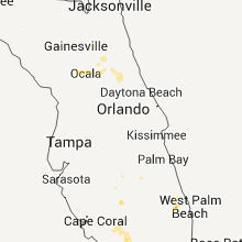
Florida
| Local Time | Report Details |
|---|---|
| 5:10 PM EDT | Quarter sized hail reported near Crescent City, FL, 62.8 miles NNW of Orlando, FL, public citizen reports hail of at least quarter size and strong wind gusts at a local restaurant in the vicinity of georgetown. time of event based on radar imagery. |
| 6:15 PM EDT | Report of a tree down near county road 346a and state road 121 with one lane blocked. time estimated by rada in alachua county FL, 73 miles SW of Jacksonville, FL |
| 6:30 PM EDT | Trees down at 259 chesser road in putnam county FL, 49.9 miles S of Jacksonville, FL |
| 6:45 PM EDT | Trained spotter reports several downed trees and large limbs along with small hail in the vicinity of anthony. time of damage based on radar imager in marion county FL, 68.2 miles NW of Orlando, FL |
| 6:55 PM EDT | Storm spotter estimates 60 mph winds in keystone height in clay county FL, 44.1 miles SSW of Jacksonville, FL |
| 7:11 PM EDT | Clay electric reports power out for 1311 customers in alachua county...and for 5000 customers area wid in alachua county FL, 61.3 miles SW of Jacksonville, FL |
| 7:28 PM EDT | Clay electric reports 1579 customers without power in marion county...and 5550 customers area wid in alachua county FL, 61.3 miles SW of Jacksonville, FL |
Indiana
| Local Time | Report Details |
|---|---|
| 4:20 PM CDT | Several trees down along highway 57 and highway 58 in extreme northwest part of warrick count in warrick county IN, 15.8 miles NNE of Evansville, IN |
| 4:26 PM CDT | Quarter sized hail reported near Elberfeld, IN, 19.4 miles NNE of Evansville, IN, reported just south of buckskin on hwy 57. |
| 5:50 PM CDT | Trees down throughout the county... trampolines and swing sets thrown near tell city in perry county IN, 50.1 miles E of Evansville, IN |
Wisconsin
| Local Time | Report Details |
|---|---|
| 4:44 PM CDT | Ping Pong Ball sized hail reported near Clintonville, WI, 37.1 miles W of Green Bay, WI |
| 4:44 PM CDT | Ping Pong Ball sized hail reported near Clintonville, WI, 36.8 miles WNW of Green Bay, WI |
| 5:45 PM CDT | Quarter sized hail reported near New London, WI, 37.7 miles WSW of Green Bay, WI, up to quarter size hail. |
| 6:42 PM CDT | Storm damage reported in winnebago county WI, 39.6 miles SW of Green Bay, WI |
| 6:48 PM CDT | Golf-ball size hail also occurre in winnebago county WI, 43.8 miles SW of Green Bay, WI |
| 6:50 PM CDT | Large tree limbs down along 9th street in winnebago county WI, 43.8 miles SW of Green Bay, WI |
| 6:53 PM CDT | Half Dollar sized hail reported near Oshkosh, WI, 43.8 miles SW of Green Bay, WI, hail fell for 2 minutes at the intersection of snell road and vinland. |
| 6:56 PM CDT | Quarter sized hail reported near Oshkosh, WI, 43.8 miles SW of Green Bay, WI, near highway 21 west of oshkosh |
| 7:00 PM CDT | Ping Pong Ball sized hail reported near Oshkosh, WI, 44.5 miles SW of Green Bay, WI, one and a half inch hail with power outages on west side of oshkosh. |
| 7:23 PM CDT | Trees down oakwood road in clayton in winnebago county WI, 35.6 miles SW of Green Bay, WI |
| 7:27 PM CDT | Storm damage reported in winnebago county WI, 43.8 miles SW of Green Bay, WI |
| 7:28 PM CDT | Storm damage reported in winnebago county WI, 49.8 miles SW of Green Bay, WI |
| 7:28 PM CDT | Relayed spotter report by e in winnebago county WI, 48.9 miles SSW of Green Bay, WI |
| 7:28 PM CDT | Relayed spotter report by e in fond du lac county WI, 51.3 miles SSW of Green Bay, WI |
| 7:35 PM CDT | One tree down on olden roa in fond du lac county WI, 55.6 miles SW of Green Bay, WI |
| 8:00 PM CDT | Trees down on hwy 52/cty rd w intersection in forest county WI, 38.6 miles ESE of Rhinelander, WI |
| 8:07 PM CDT | Tree dow in fond du lac county WI, 53.8 miles SSW of Green Bay, WI |
| 11:35 PM CDT | Power line down. delayed report from county dispatch. time estimated by rada in vilas county WI, 31.7 miles NW of Rhinelander, WI |
| 11:35 PM CDT | Numerous trees and power lines down along co rd ff in iron county WI, 48.2 miles NW of Rhinelander, WI |
| 12:00 AM CDT | Quarter sized hail reported near Crandon, WI, 25.4 miles ESE of Rhinelander, WI, wind gusts between 40 and 45 mph |
| 12:10 AM CDT | Golf Ball sized hail reported near Crandon, WI, 25.4 miles ESE of Rhinelander, WI, delayed public report via wjfw-tv. |
| 12:50 AM CDT | Widespread wind damage across the count in forest county WI, 35.9 miles E of Rhinelander, WI |
| 1:16 AM CDT | Quarter sized hail reported near Danbury, WI, 53.8 miles S of Duluth, MN |
| 3:14 AM CDT | Large pine tree snapped off and fell on boat...several 3 to 6in branches also down in town...time estimated from radar in barron county WI, 82.6 miles ENE of Minneapolis, MN |
| 3:25 AM CDT | Storm damage reported in rusk county WI, 82.9 miles W of Rhinelander, WI |
| 3:35 AM CDT | Power lines dow in rusk county WI, 91 miles W of Rhinelander, WI |
Missouri
| Local Time | Report Details |
|---|---|
| 5:09 PM CDT | Storm damage reported in maries county MO, 34.9 miles NNW of Salem, MO |
| 7:10 PM CDT | 5th wheel camper overturned...corn flattened...some trees uprooted and snapped off. time estimated correcte in lewis county MO, 30.6 miles SSE of Kahoka, MO |
| 8:45 PM CDT | 5th wheel camper overturned...corn flattened...some trees uprooted and snapped off. time estimate in lewis county MO, 30.6 miles SSE of Kahoka, MO |
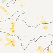
Michigan
| Local Time | Report Details |
|---|---|
| 10:55 PM CDT | Ironwood police report dozens of downed powerlines or downed trees blocking the roa in gogebic county MI, 66.4 miles NNW of Rhinelander, WI |
| 10:55 PM CDT | 8-10 inch diameter tree came down in strong winds and was snapped of in gogebic county MI, 67.5 miles NNW of Rhinelander, WI |
| 10:57 PM CDT | Sheriff recieved reports of numerous trees and powerlines downed across gogebic count in gogebic county MI, 65.7 miles NNW of Rhinelander, WI |
| 10:57 PM CDT | Time estimated. 8inch dead tree snapped at base and prtable basketball hoop broke in hal in gogebic county MI, 65.7 miles NNW of Rhinelander, WI |
| 12:19 AM EDT | Ontonagon sheriff received numerous reports of downed trees and powerlines downed on the southern end of ontonagon county...near bergland along m6 in ontonagon county MI, 66.9 miles N of Rhinelander, WI |
| 12:45 AM EDT | Trees downed on a powerline. no specifics known on diameter or timin in ontonagon county MI, 53.8 miles NNE of Rhinelander, WI |
| 1:05 AM EDT | 911 dispatcher said there were reports of trees down on a powerline near lake linden. there was an additional report of trees down on us 41 north of hancoc in houghton county MI, 66.9 miles NW of Marquette, MI |
| 1:07 AM EDT | Large trees downed on powerlines and across road 10 miles south of m28 on us 14 in baraga county MI, 54.2 miles W of Marquette, MI |
| 1:20 AM EDT | Several 6 to 8 inch diameter trees downe in baraga county MI, 51 miles WNW of Marquette, MI |
| 1:25 AM EDT | 1-2 feet diameter willow tree snapped off. 3-4 foot base on willow tree. debris from trees all over yar in lsz247 county MI, 52.3 miles WNW of Marquette, MI |
| 1:25 AM EDT | 1-2 feet diameter willow tree snapped off. 3-4 foot base on willow tree. debris from trees all over yar in baraga county MI, 51.2 miles WNW of Marquette, MI |
| 12:30 AM CDT | 911 dispatcher said there have been numerous calls about downed powerlines and tree damage. no specifics on location were availabl in gogebic county MI, 45 miles NNE of Rhinelander, WI |
| 1:30 AM EDT | Tree fell on camper trailer at van riper state park. trailer was totaled...but no injuries occurre in marquette county MI, 27.5 miles W of Marquette, MI |
| 1:30 AM EDT | Several trees down...dock ripped off...and ponding water at fence lake in baraga county MI, 36.8 miles W of Marquette, MI |
| 1:45 AM EDT | Report from 911 dispatcher of trees blocking the roa in keweenaw county MI, 67.7 miles NNW of Marquette, MI |
| 1:45 AM EDT | 911 dispatcher said numerous reports across the county of downed trees blocking the road. most trees were approximately 6 inches to 1 ft in diamete in keweenaw county MI, 67.7 miles NNW of Marquette, MI |
| 1:55 AM EDT | 63 mph wind gust measured at big bay glos sit in marquette county MI, 24.7 miles NW of Marquette, MI |
| 2:00 AM EDT | 911 dispatcher said numerous reports across the county of downed trees blocking the road. most trees were approximately 6 inches to 1 ft in diamete in keweenaw county MI, 67.7 miles NNW of Marquette, MI |
| 2:05 AM EDT | Report from 911 dispatcher of trees blocking the roa in keweenaw county MI, 67.7 miles NNW of Marquette, MI |
| 2:15 AM EDT | 911 dispatcher said there were reports of trees down on a powerline near lake linden. there was an additional report of trees down on us 41 north of hancoc in houghton county MI, 66.9 miles NW of Marquette, MI |
| 1:20 AM CDT | Sheriff recieved reports of numerous trees and powerlines downed across gogebic count in gogebic county MI, 65.7 miles NNW of Rhinelander, WI |
| 1:20 AM CDT | Ironwood police report dozens of downed powerlines or downed trees blocking the roa in gogebic county MI, 66.4 miles NNW of Rhinelander, WI |
| 2:30 AM EDT | Ontonagon sheriff received numerous reports of downed trees and powerlines downed on the southern end of ontonagon county...near bergland along m6 in ontonagon county MI, 66.9 miles N of Rhinelander, WI |
| 2:30 AM EDT | Large trees downed on powerlines and across road 10 miles south of m28 on us 14 in baraga county MI, 54.2 miles W of Marquette, MI |
| 2:30 AM EDT | Trees downed on a powerline. no specifics known on diameter or timin in ontonagon county MI, 53.8 miles NNE of Rhinelander, WI |
| 4:00 AM EDT | Tree down on vandecar road. time estimated from rada in isabella county MI, 70.8 miles NE of Grand Rapids, MI |
| 5:03 AM EDT | Tree down in village of kalkaska. time based on rada in kalkaska county MI, 21.5 miles E of Traverse City, MI |
| 5:10 AM EDT | Tree down in manistee lake. time based on rada in kalkaska county MI, 28.4 miles E of Traverse City, MI |
| 5:17 AM EDT | Numerous trees and signs down along route m115 near farwell and clar in isabella county MI, 70.8 miles NE of Grand Rapids, MI |
| 5:50 AM EDT | Utility pole down and on fire at farrand rd and sheridan. also trees down in the area in genesee county MI, 17.5 miles NW of Flint, MI |
| 5:53 AM EDT | Tree down in markey township. time based on rada in roscommon county MI, 54.2 miles ESE of Traverse City, MI |
| 5:57 AM EDT | 8 inch diameter trees down at clio and pasadena roads in genesee county MI, 3.5 miles NW of Flint, MI |
| 5:57 AM EDT | Golf Ball sized hail reported near Flint, MI, 3.6 miles SW of Flint, MI, at van slyke and bristol roads |
| 6:00 AM EDT | Large downed tree in saginaw county MI, 36.2 miles WNW of Flint, MI |
| 6:01 AM EDT | Storm damage reported in genesee county MI, 5.2 miles SSE of Flint, MI |
| 6:01 AM EDT | Golf Ball sized hail reported near Grand Blanc, MI, 5.2 miles SSE of Flint, MI |
| 6:02 AM EDT | At van slyke and bristol roads in genesee county MI, 3.1 miles SSW of Flint, MI |
Idaho
| Local Time | Report Details |
|---|---|
| 9:35 PM PDT | Quarter sized hail reported near Plummer, ID, 38.8 miles ESE of Spokane, WA, mostly pea to dime size...but a few nickel to quarter size hail stones. hail lasted 4 minutes. |
| 10:08 PM PDT | Golf Ball sized hail reported near Tensed, ID, 38 miles SE of Spokane, WA, time estimated. report relayed from dispatch. |
Connect with Interactive Hail Maps