

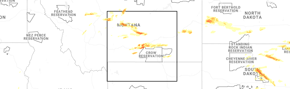
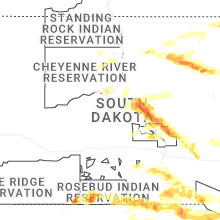
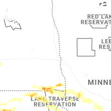
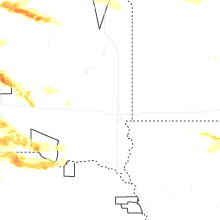
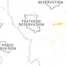
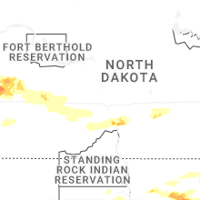
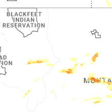
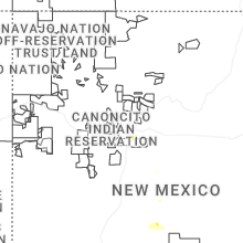
Hail Map for Monday, July 28, 2025
Number of Impacted Households on 7/28/2025
0
Impacted by 1" or Larger Hail
0
Impacted by 1.75" or Larger Hail
0
Impacted by 2.5" or Larger Hail
Square Miles of Populated Area Impacted on 7/28/2025
0
Impacted by 1" or Larger Hail
0
Impacted by 1.75" or Larger Hail
0
Impacted by 2.5" or Larger Hail

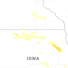
Cities Most Affected by Hail Storms of 7/28/2025
| Hail Size | Demographics of Zip Codes Affected | ||||||
|---|---|---|---|---|---|---|---|
| City | Count | Average | Largest | Pop Density | House Value | Income | Age |
| Cresbard, SD | 2 | 3.13 | 3.50 | 1 | $23k | $30.4k | 49.5 |
| Northville, SD | 3 | 2.08 | 2.75 | 2 | $36k | $36.9k | 42.8 |
| Mills, NE | 1 | 2.50 | 2.50 | 1 | $72k | $23.4k | 50.2 |
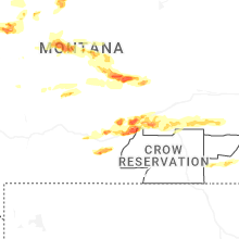
| Lewistown, MT | 1 | 2.50 | 2.50 | 8 | $74k | $30.8k | 47.6 |
| Joliet, MT | 1 | 2.00 | 2.00 | 5 | $94k | $32.3k | 46.1 |
| Roundup, MT | 1 | 1.75 | 1.75 | 4 | $55k | $25.4k | 48.9 |
| Saint Francis, SD | 1 | 1.75 | 1.75 | 0 | $10k | $19.4k | 22.8 |
| Lower Brule, SD | 1 | 1.75 | 1.75 | 1 | $44k | $20.4k | 22.7 |
| Billings, MT | 1 | 1.75 | 1.75 | 75 | $81k | $26.8k | 34.8 |
| Eden, SD | 1 | 1.75 | 1.75 | 3 | $33k | $23.8k | 47.6 |
| Burke, SD | 1 | 1.75 | 1.75 | 2 | $42k | $22.3k | 46.6 |
Hail and Wind Damage Spotted on 7/28/2025
Filter by Report Type:Hail ReportsWind Reports
States Impacted
North Dakota, Montana, Wisconsin, Tennessee, North Carolina, Michigan, Ohio, South Dakota, Nebraska, Indiana, Minnesota, Kentucky, Iowa, New Mexico, Nevada, IllinoisNorth Dakota
| Local Time | Report Details |
|---|---|
| 6:20 AM MDT | 50-60 mph winds reported. torrential rainfall... pea size hail... and frequent lightning also were reporte in billings county ND, 65.4 miles SSE of Williston, ND |
| 6:35 AM MDT | Photo on social media shows multiple 115 kv power lines down 4n6w of fairfield. time estimated by radar... and in association with a 75 mph wind gust reported by the fa in billings county ND, 68.2 miles SSE of Williston, ND |
| 6:35 AM MDT | Ndawn 2w fairfield report at 10 meters... 62 mph at the surfac in billings county ND, 72.5 miles SSE of Williston, ND |
| 7:08 AM MDT | Davis weather station observation. peak wind gus in dunn county ND, 76.9 miles SSE of Williston, ND |
| 7:10 AM MDT | Ndawn mesonet statio in dunn county ND, 80.8 miles SSE of Williston, ND |
| 7:15 AM MDT | Observation relayed through emergency manage in stark county ND, 96.5 miles SSE of Williston, ND |
| 7:30 AM MDT | Gladstone nd dot observation sit in stark county ND, 84.1 miles W of Bismarck, ND |
| 7:30 AM MDT | Wind gusts estimated 65-70 mph. very heavy rai in stark county ND, 95.5 miles W of Bismarck, ND |
| 7:30 AM MDT | Emergency management relays a photo of a medium to large tree branch felled. time estimated by radar... and in association with a report of a 65 mph wind gust in dickin in stark county ND, 95.2 miles SSE of Williston, ND |
| 7:30 AM MDT | Emergency manager relays a picture of a split medium-sized tree. split occurred near a forked section of the tree. time estimated by radar... and in association with a in stark county ND, 95 miles W of Bismarck, ND |
| 8:05 AM MDT | Private weather station peak wind gus in stark county ND, 66.7 miles W of Bismarck, ND |
| 9:35 AM CDT | Awos station kd57 glen ulli in morton county ND, 51.7 miles W of Bismarck, ND |
| 10:54 AM CDT | Private weather sensor south side of bismarck. most wind reports in the bismarck/mandan area were up to around 50 mp in burleigh county ND, 3.3 miles SSW of Bismarck, ND |
| 5:10 PM CDT | Half Dollar sized hail reported near Cayuga, ND, 65.3 miles NE of Aberdeen, SD, photo showing collection of hail estimated to be the size of half dollars. time estimated via radar. |
| 5:15 PM CDT | Quarter sized hail reported near Lidgerwood, ND, 65.7 miles SSW of Fargo, ND, call out to area lodge hotel resulted in public observing mostly pea to nickel sized hail... with up to quarter sized hail intermixed. location of observation was 6 mil |
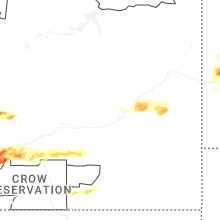
Montana
| Local Time | Report Details |
|---|---|
| 9:00 AM MDT | Quarter sized hail reported near Ismay, MT, 49.8 miles E of Miles City, MT |
| 2:36 PM MDT | Quarter sized hail reported near Clancy, MT, 71.7 miles NW of Bozeman, MT, trained spotter reports hail slightly larger than quarter sized. |
| 3:11 PM MDT | Half Dollar sized hail reported near East Helena, MT, 66.6 miles NNW of Bozeman, MT, social media report estimating max hail size of 1.25 inches. time estimated. |
| 5:10 PM MDT | Montana mesonet sensor judith ga in judith basin county MT, 88.6 miles NW of Billings, MT |
| 5:10 PM MDT | Spotter reported tree limbs up to 8 inches in diameter blown off of their cottonwood tree. time estimated by rada in fergus county MT, 91 miles ESE of Great Falls, MT |
| 5:25 PM MDT | Tennis Ball sized hail reported near Lewistown, MT, 86.9 miles NNW of Billings, MT, spotter reported hail between 2 to 2.5 inches in diameter. the spotter also noted the hail punched a hole into their deck. |
| 7:16 PM MDT | Quarter sized hail reported near Roundup, MT, 46 miles N of Billings, MT |
| 7:17 PM MDT | Golf Ball sized hail reported near Roundup, MT, 47.8 miles N of Billings, MT, trees stripped badly. |
| 7:22 PM MDT | Half Dollar sized hail reported near Roundup, MT, 48.8 miles N of Billings, MT, hail went thru patio roof. drifts of hail. flooding into basement. |
| 8:15 PM MDT | Mesonet station mting 1.6 w ingomar (mt dot in rosebud county MT, 74.9 miles W of Miles City, MT |
| 9:15 PM MDT | Mesonet station mtm89 angela in rosebud county MT, 40.7 miles WNW of Miles City, MT |
| 9:17 PM MDT | Ping Pong Ball sized hail reported near Billings, MT, 11.7 miles WNW of Billings, MT |
| 9:30 PM MDT | Mesonet station mthil 1.6 nw rock springs (mt dot in rosebud county MT, 35.4 miles NW of Miles City, MT |
| 10:01 PM MDT | Ping Pong Ball sized hail reported near Billings, MT, 3.3 miles NNE of Billings, MT |
| 10:10 PM MDT | Driver had a hard time controlling jeep and had to pull ove in mccone county MT, 61.9 miles N of Miles City, MT |
| 10:10 PM MDT | Quarter sized hail reported near Billings, MT, 10.3 miles WSW of Billings, MT, 3 inches of hail accumulation on ground. |
| 10:30 PM MDT | Ping Pong Ball sized hail reported near Laurel, MT, 9.2 miles SW of Billings, MT |
| 10:30 PM MDT | Golf Ball sized hail reported near Billings, MT, 3.9 miles SSW of Billings, MT, shredded leaves... car dents... damaged shingles. |
| 10:35 PM MDT | Hen Egg sized hail reported near Joliet, MT, 30.8 miles SW of Billings, MT, image on facebook shows hailstone sightly smaller than a tennis ball. |
| 10:45 PM MDT | Mesonet station sdam8 soda spring in yellowstone county MT, 6.3 miles SE of Billings, MT |
| 11:00 PM MDT | Mesonet station mtarc 11.8 s ballantine (arrow creek hill dot in yellowstone county MT, 16.7 miles E of Billings, MT |
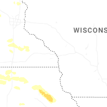
Wisconsin
| Local Time | Report Details |
|---|---|
| 11:45 AM CDT | Trees and power lines down in buffalo city and fountain city areas. time estimated from rada in buffalo county WI, 30.8 miles NW of La Crosse, WI |
| 9:48 PM CDT | Reports of several trees down in the village of somerset. as well as reports of downed power lines. time estimated via rada in st. croix county WI, 30.5 miles ENE of Minneapolis, MN |
| 9:55 PM CDT | Dozens of trees down... many of which were across roads from houlton to new richmon in st. croix county WI, 30.5 miles ENE of Minneapolis, MN |
| 10:04 PM CDT | 5 inch trees snapped in yard. time approximat in st. croix county WI, 38.6 miles ENE of Minneapolis, MN |
| 10:05 PM CDT | Multiple trees larger than 1 foot in diameter snapped or uprooted along 172nd avenue in new richmond. time estimated from rada in st. croix county WI, 35.7 miles ENE of Minneapolis, MN |
| 10:10 PM CDT | Large tree branches down. power out. time estimated by rada in st. croix county WI, 43.4 miles E of Minneapolis, MN |
| 10:15 PM CDT | Trees and power lines reported dow in pierce county WI, 28.2 miles SE of Minneapolis, MN |
| 10:18 PM CDT | Storm damage reported in st. croix county WI, 43.4 miles E of Minneapolis, MN |
| 10:25 PM CDT | Trees and power lines reported dow in pierce county WI, 41.9 miles ESE of Minneapolis, MN |
| 10:25 PM CDT | Downed large tree blocking the road near van buren and silver fox in spring valley. time estimated from rada in pierce county WI, 50.2 miles E of Minneapolis, MN |
| 10:35 PM CDT | Measured at red wing airpor in pierce county WI, 47 miles SE of Minneapolis, MN |
| 10:37 PM CDT | Measured with home weather station. several branches dow in chippewa county WI, 85 miles E of Minneapolis, MN |
| 10:45 PM CDT | Trees and power lines reported dow in dunn county WI, 65.9 miles E of Minneapolis, MN |
| 11:00 PM CDT | Tree down across roa in pepin county WI, 66.7 miles ESE of Minneapolis, MN |
| 11:00 PM CDT | Several trees down across roads in the stockholm and pepin area in pepin county WI, 63.5 miles SE of Minneapolis, MN |
| 11:05 PM CDT | Tree down across roa in pepin county WI, 66.2 miles NNW of La Crosse, WI |
| 11:20 PM CDT | About one dozen trees across roads in various parts of the city. some power lines also dow in eau claire county WI, 70.6 miles N of La Crosse, WI |
| 11:26 PM CDT | Storm damage reported in buffalo county WI, 55.2 miles NNW of La Crosse, WI |
| 11:45 PM CDT | Corrects previous tstm wnd dmg report from fountain city. trees and power lines down in buffalo city and fountain city areas. time estimated from rada in buffalo county WI, 30.8 miles NW of La Crosse, WI |
| 11:50 PM CDT | Storm damage reported in buffalo county WI, 38.1 miles NNW of La Crosse, WI |
| 12:20 AM CDT | Asos station klse la crosse regional airpor in la crosse county WI, 4.7 miles N of La Crosse, WI |
| 12:25 AM CDT | Asos station klse la crosse regional airpor in la crosse county WI, 4.7 miles N of La Crosse, WI |
| 12:30 AM CDT | Large tree and some smaller trees down across bliss roa in la crosse county WI, 3.1 miles E of La Crosse, WI |
| 12:53 AM CDT | Asos station klse la crosse regional airpor in la crosse county WI, 4.7 miles N of La Crosse, WI |
Tennessee
| Local Time | Report Details |
|---|---|
| 2:15 PM EDT | Several trees dow in greene county TN, 41.3 miles SW of Bristol, TN |
North Carolina
| Local Time | Report Details |
|---|---|
| 3:30 PM EDT | Fire department dispatched at 429 pm to remove a fallen tree at olive branch rd. and christian light rd. time of event estimated from rada in harnett county NC, 25.3 miles SSW of Raleigh, NC |
| 3:53 PM EDT | Duke energy outage caused by damaged equipment from fallen trees or limb in harnett county NC, 29.5 miles SSW of Raleigh, NC |
Michigan
| Local Time | Report Details |
|---|---|
| 3:36 PM EDT | Numerous downed power lines in the romulus are in wayne county MI, 56.9 miles SSE of Flint, MI |
| 7:24 PM EDT | Numerous trees and powers lines dow in bay county MI, 52.5 miles NNW of Flint, MI |
| 7:30 PM EDT | Storm damage reported in bay county MI, 48.3 miles NNW of Flint, MI |
Ohio
| Local Time | Report Details |
|---|---|
| 5:00 PM EDT | Mesonet station hhlo1 huro in lez144 county OH, 45.2 miles W of Cleveland, OH |
| 7:00 PM EDT | Trees and limbs downed and portions of corn fields blown down. damage occurred just east of route 3 between fox lake road and pleasant home road. time estimated via rad in wayne county OH, 43.1 miles SSW of Cleveland, OH |
| 7:14 PM EDT | A downed tree in the neelysville area resulted in local power outages. time estimated from rada in morgan county OH, 72.7 miles ESE of Columbus, OH |
| 7:50 PM EDT | Tree down across roadway. time estimated via rada in stark county OH, 40.5 miles SSE of Cleveland, OH |
| 9:42 PM EDT | One tree downed on west north street. tree was noted to have been struck by lightning previously... but appeared to be healthy at this tim in clark county OH, 44.5 miles W of Columbus, OH |
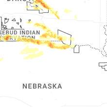
South Dakota
| Local Time | Report Details |
|---|---|
| 4:15 PM CDT | Quarter sized hail reported near Hamill, SD, 62.6 miles NE of Valentine, NE |
| 4:19 PM CDT | Half Dollar sized hail reported near Saint Francis, SD, 25.9 miles NW of Valentine, NE, report from mping: half dollar (1.25 in.). |
| 4:21 PM CDT | Golf Ball sized hail reported near Saint Francis, SD, 25 miles NW of Valentine, NE, report from mping: golf ball (1.75 in.). |
| 4:40 PM CDT | Half Dollar sized hail reported near Harrold, SD, 31 miles ENE of Pierre, SD |
| 5:06 PM CDT | Ping Pong Ball sized hail reported near Highmore, SD, 45.9 miles E of Pierre, SD |
| 5:12 PM CDT | Quarter sized hail reported near Roscoe, SD, 42.1 miles WSW of Aberdeen, SD |
| 5:15 PM CDT | Ping Pong Ball sized hail reported near Winner, SD, 15.2 miles NE of Valentine, NE |
| 5:26 PM CDT | Golf Ball sized hail reported near Eden, SD, 54.9 miles ENE of Aberdeen, SD |
| 5:35 PM CDT | Quarter sized hail reported near Winner, SD, 23.9 miles ENE of Valentine, NE |
| 5:35 PM CDT | Quarter sized hail reported near Britton, SD, 39.7 miles ENE of Aberdeen, SD, inch hail reported 3 w and 3 s of britton. |
| 5:39 PM CDT | Ping Pong Ball sized hail reported near Ipswich, SD, 30.1 miles WSW of Aberdeen, SD |
| 5:40 PM CDT | Tea Cup sized hail reported near Cresbard, SD, 25.6 miles SW of Aberdeen, SD, image of hail stone next to tape measure reported on facebook. |
| 5:45 PM CDT | Baseball sized hail reported near Cresbard, SD, 25.3 miles SW of Aberdeen, SD |
| 6:00 PM CDT | Wind driven hail. several broken windows of cars and damage to siding of the hous in faulk county SD, 25.7 miles SW of Aberdeen, SD |
| 6:00 PM CDT | Baseball sized hail reported near Northville, SD, 22.5 miles SSW of Aberdeen, SD |
| 6:03 PM CDT | Golf Ball sized hail reported near Northville, SD, 22.5 miles SSW of Aberdeen, SD, 2 miles east of chelsea on the south side of the sd hwy 20 received crop damage. |
| 6:05 PM CDT | Quarter sized hail reported near Roslyn, SD, 52.5 miles E of Aberdeen, SD |
| 6:07 PM CDT | Quarter sized hail reported near New Effington, SD, 70.5 miles S of Fargo, ND, report and photo of quarter sized hail on facebook. |
| 6:09 PM CDT | Golf Ball sized hail reported near Northville, SD, 22.5 miles SSW of Aberdeen, SD |
| 6:15 PM CDT | Golf Ball sized hail reported near Burke, SD, 59.6 miles NNW of Oneill, NE, 15 minutes of hail varied in size from quarters to golf balls... with most of them quarter to half dollar sized. |
| 6:19 PM CDT | Quarter sized hail reported near Mellette, SD, 21.4 miles S of Aberdeen, SD, report from social media. |
| 6:39 PM CDT | Mesonet station 55 summit (sddot in roberts county SD, 69.7 miles WNW of Montevideo, MN |
| 6:44 PM CDT | Mesonet station 55 summit (sddot in roberts county SD, 69.7 miles WNW of Montevideo, MN |
| 6:50 PM CDT | Golf Ball sized hail reported near Lower Brule, SD, 41.6 miles ESE of Pierre, SD |
| 7:15 PM CDT | Mesonet station 292 7ne milbank (sddot in grant county SD, 44.6 miles WNW of Montevideo, MN |
| 7:17 PM CDT | Personal weather statio in charles mix county SD, 46.7 miles NNE of Oneill, NE |
| 7:40 PM CDT | Corrects previous non-tstm wnd gst report from 4 ne dante. mesonet station 324 sd rwis wagne in charles mix county SD, 50.4 miles NNE of Oneill, NE |
| 7:53 PM CDT | Personal weather statio in bon homme county SD, 60.5 miles NE of Oneill, NE |
| 7:59 PM CDT | Personal weather statio in bon homme county SD, 58.2 miles WSW of Sioux Falls, SD |
| 8:05 PM CDT | Corrects previous non-tstm wnd gst report from 3 s scotland. mesonet station dvi02596 scotlan in bon homme county SD, 58.6 miles WSW of Sioux Falls, SD |
| 8:18 PM CDT | Personal weather statio in yankton county SD, 48.7 miles SW of Sioux Falls, SD |
| 8:29 PM CDT | Personal weather statio in mccook county SD, 21.5 miles W of Sioux Falls, SD |
| 8:36 PM CDT | Personal weather statio in turner county SD, 38.7 miles SW of Sioux Falls, SD |
| 8:48 PM CDT | Personal weather statio in minnehaha county SD, 5 miles SW of Sioux Falls, SD |
| 8:49 PM CDT | Large tree limbs broken down by winds estimated at 65 mp in minnehaha county SD, 4.6 miles WSW of Sioux Falls, SD |
| 8:51 PM CDT | Personal weather stataio in minnehaha county SD, 5.1 miles WSW of Sioux Falls, SD |
| 8:51 PM CDT | Mesonet station 320 sd rwis iren in turner county SD, 36.6 miles SSW of Sioux Falls, SD |
| 8:53 PM CDT | Thunderstorm wind gusts tore the roof off a house and uprooted a large tree. time estimated from rada in turner county SD, 21.3 miles SW of Sioux Falls, SD |
| 8:53 PM CDT | Tree and powerline damag in union county SD, 32.2 miles S of Sioux Falls, SD |
| 8:55 PM CDT | Mesonet station bfms2 beresford 7 ws in clay county SD, 35.9 miles SSW of Sioux Falls, SD |
| 8:56 PM CDT | Personal weather statio in lincoln county SD, 7.5 miles SW of Sioux Falls, SD |
| 8:57 PM CDT | Mesonet station 310 sd rwis parke in turner county SD, 21.3 miles SW of Sioux Falls, SD |
| 8:59 PM CDT | Asos station kfsd sioux falls airpor in minnehaha county SD, 2.6 miles NNW of Sioux Falls, SD |
| 9:02 PM CDT | Tree and powerline damag in union county SD, 36.6 miles S of Sioux Falls, SD |
| 9:09 PM CDT | Personal weather statio in lincoln county SD, 7.6 miles SSE of Sioux Falls, SD |
| 9:13 PM CDT | Mesonet station 16 sd rwis beresfor in union county SD, 35.1 miles S of Sioux Falls, SD |
| 9:19 PM CDT | Personal weather statio in union county SD, 35.1 miles S of Sioux Falls, SD |
Nebraska
| Local Time | Report Details |
|---|---|
| 4:55 PM CDT | Asos station kvtn valentine airpor in cherry county NE, 1 miles S of Valentine, NE |
| 4:33 PM MDT | Quarter sized hail reported near Hyannis, NE, 74.9 miles NW of North Platte, NE |
| 6:16 PM CDT | Quarter sized hail reported near Springview, NE, 46.8 miles E of Valentine, NE |
| 6:26 PM CDT | Tennis Ball sized hail reported near Mills, NE, 53 miles E of Valentine, NE, time estimated from radar. |
| 6:52 PM CDT | Quarter sized hail reported near Naper, NE, 43.9 miles NW of Oneill, NE, time estimated from radar. |
| 7:06 PM CDT | Quarter sized hail reported near Naper, NE, 39.3 miles NW of Oneill, NE, time estimated from radar. |
| 7:24 PM CDT | Quarter sized hail reported near Atkinson, NE, 28.1 miles NNW of Oneill, NE, time estimated from radar. |
| 7:55 PM CDT | Quarter sized hail reported near Lynch, NE, 27.3 miles NNE of Oneill, NE, time estimated from radar. |
| 8:23 PM CDT | Quarter sized hail reported near Niobrara, NE, 33.8 miles ENE of Oneill, NE, time estimated from radar. |
Indiana
| Local Time | Report Details |
|---|---|
| 6:20 PM EDT | One tree down across the roadway at state route 62 and south cave hill roa in ripley county IN, 36 miles WSW of Cincinnati, OH |
| 6:46 PM EDT | Multiple trees and power lines down in the area of 2nd... 3rd... 4th... and 5th street and market street. time estimated from rada in clark county IN, 33.4 miles N of Louisville, KY |
| 7:15 PM EDT | Numerous spots in town with trees and lines down. roof damage to a structure on lawton stree in knox county IN, 57.1 miles NNE of Evansville, IN |
| 7:48 PM EDT | Tree down on a transformer in otwel in pike county IN, 42.1 miles NE of Evansville, IN |
| 7:12 PM CDT | Large tree limb across highway 64... tree on camper in oakland cit in gibson county IN, 28.4 miles NNE of Evansville, IN |
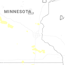
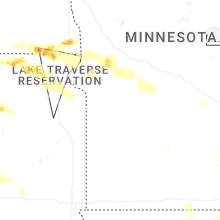
Minnesota
| Local Time | Report Details |
|---|---|
| 7:15 PM CDT | Awos station kvvv ortonville muni a in big stone county MN, 41.9 miles NW of Montevideo, MN |
| 7:20 PM CDT | Mesonet station mn137 u.s.75 - ortonville - mp 132. in big stone county MN, 39.6 miles NW of Montevideo, MN |
| 7:20 PM CDT | Along cr 29 north of mill lake. portion of a roof of a shed blown off. fish house blown around. relayed by county dispatc in todd county MN, 89.2 miles NNE of Montevideo, MN |
| 9:09 PM CDT | Hutchinson airpor in mcleod county MN, 55.3 miles W of Minneapolis, MN |
| 9:10 PM CDT | Ten inch tree broke in sherburne county MN, 27.8 miles NW of Minneapolis, MN |
| 9:18 PM CDT | Tree down on house. time estimated based on rada in mcleod county MN, 38.5 miles W of Minneapolis, MN |
| 9:29 PM CDT | Glencoe airpor in mcleod county MN, 42.8 miles WSW of Minneapolis, MN |
| 9:29 PM CDT | 12 inch diameter tree snapped at the bas in carver county MN, 30.8 miles WSW of Minneapolis, MN |
| 9:30 PM CDT | Tree down across much of main st at 37th. time estimated based on rada in anoka county MN, 4.2 miles N of Minneapolis, MN |
| 9:30 PM CDT | Large tree down approximately 18 inches in diameter. near 85th ave and spring lake road in mounds view. time estimated based on rada in ramsey county MN, 9.9 miles N of Minneapolis, MN |
| 9:40 PM CDT | Two trees down on the north side of white bear lak in ramsey county MN, 15.4 miles ENE of Minneapolis, MN |
| 9:45 PM CDT | Measured by meteorologis in hennepin county MN, 7.6 miles S of Minneapolis, MN |
| 9:45 PM CDT | Trees down... including some on valley view rd. time estimated based on rada in hennepin county MN, 8 miles SW of Minneapolis, MN |
| 9:47 PM CDT | Measured at msp airpor in hennepin county MN, 6.4 miles SSE of Minneapolis, MN |
| 9:49 PM CDT | Measured by scott county mesone in scott county MN, 17.4 miles SW of Minneapolis, MN |
| 9:50 PM CDT | Tree down on southview blvd near hwy 5 in dakota county MN, 11.8 miles ESE of Minneapolis, MN |
| 9:50 PM CDT | Three to four inch branches broken off of healthy trees. time estimated based on rada in washington county MN, 19.6 miles E of Minneapolis, MN |
| 9:54 PM CDT | Storm damage reported in scott county MN, 15.8 miles SSW of Minneapolis, MN |
| 9:55 PM CDT | Report of downed maple tree in backyar in scott county MN, 35.4 miles SW of Minneapolis, MN |
| 9:55 PM CDT | Large tree downed in eden prairie. photo report via in hennepin county MN, 13 miles SW of Minneapolis, MN |
| 9:56 PM CDT | Large tree snapped in belle plaine. photo report via x. time estimated rada in scott county MN, 34.9 miles SW of Minneapolis, MN |
| 9:56 PM CDT | Corrects previous tstm wnd gst report from 3 nnw new prague. measured by scott county mesone in scott county MN, 31.3 miles SSW of Minneapolis, MN |
| 10:02 PM CDT | Measured at cr27 and longvie in scott county MN, 23.4 miles SSW of Minneapolis, MN |
| 10:05 PM CDT | Report of downed power lines near highway 3 in rosemount. time estimated from rada in dakota county MN, 17.8 miles SSE of Minneapolis, MN |
| 10:10 PM CDT | Large healthy pine tree snapped about 15 feet above ground... with its top resting on a house. this was near the intersection of 3rd street ne and linden avenue. large in le sueur county MN, 40.3 miles SSW of Minneapolis, MN |
| 10:12 PM CDT | Report of multiple trees down near the high school in montgomery. time estimated via rada in le sueur county MN, 40.3 miles SSW of Minneapolis, MN |
| 10:25 PM CDT | Half Dollar sized hail reported near Morristown, MN, 53.8 miles S of Minneapolis, MN |
| 10:27 PM CDT | At faribault airport. a three inch diameter tree was reported down near the airpor in rice county MN, 44.9 miles S of Minneapolis, MN |
| 10:40 PM CDT | Measured at owatonna airpor in steele county MN, 59.3 miles S of Minneapolis, MN |
| 10:50 PM CDT | Tree down across cassandra s in scott county MN, 19.1 miles SSW of Minneapolis, MN |
| 11:00 PM CDT | Mesonet station mn143 u.s.63 - lake city - mp 62. in wabasha county MN, 60.5 miles SE of Minneapolis, MN |
| 11:05 PM CDT | Mesonet station mn029 u.s.14 - byron - mp 20 in dodge county MN, 65.1 miles NNE of Mason City, IA |
| 11:08 PM CDT | 8 inch diameter tree limb snappe in olmsted county MN, 62.9 miles WNW of La Crosse, WI |
| 11:15 PM CDT | Awos station k9mn mayo helipa in olmsted county MN, 62.9 miles WNW of La Crosse, WI |
| 11:20 PM CDT | Asos station krst rochester international airpor in olmsted county MN, 62.6 miles W of La Crosse, WI |
| 11:30 PM CDT | Mesonet station mn144 u.s.218 - lyle - mp in mower county MN, 31.2 miles NNE of Mason City, IA |
| 11:35 PM CDT | Numerous trees down. time estimated from rada in fillmore county MN, 44.2 miles W of La Crosse, WI |
| 11:50 PM CDT | Awos station kfka preston airpor in fillmore county MN, 46.9 miles W of La Crosse, WI |
| 12:00 AM CDT | Mesonet station mn065 t.h.52 - canton - mp in fillmore county MN, 37.8 miles WSW of La Crosse, WI |
| 12:00 AM CDT | Several trees dow in winona county MN, 28.9 miles NW of La Crosse, WI |
Kentucky
| Local Time | Report Details |
|---|---|
| 8:05 PM CDT | Numerous trees and power lines down in and east of owensbor in daviess county KY, 28.6 miles ESE of Evansville, IN |
| 8:32 PM CDT | Report of numerous trees downed in beaver dam... including along us hwy 6 in ohio county KY, 54.7 miles SE of Evansville, IN |
| 8:41 PM CDT | Downed trees in rockport. time estimated from rada in ohio county KY, 54 miles SE of Evansville, IN |
| 8:42 PM CDT | Numerous power outages eastern portion of county north of livermor in mclean county KY, 36.6 miles SE of Evansville, IN |
| 8:50 PM CDT | Numerous trees and power lines down in central cit in muhlenberg county KY, 52.4 miles SSE of Evansville, IN |
| 10:32 PM EDT | Corrects previous report from 2 nne mchargue. several trees down near the campground elementary school and campground fire department off of ky22 in laurel county KY, 45.5 miles S of Irvine, KY |
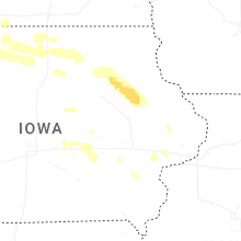
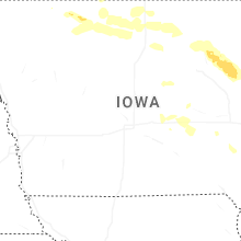
Iowa
| Local Time | Report Details |
|---|---|
| 9:10 PM CDT | Trees knocked down by thunderstorm wind gust in sioux county IA, 39.7 miles SSE of Sioux Falls, SD |
| 9:22 PM CDT | Em reports a tree with a roughly 5 foot diameter knocked down. tree appears at least partially rotted from photo in sioux county IA, 37.4 miles SSE of Sioux Falls, SD |
| 9:26 PM CDT | Trees knocked down by thunderstorm wind gust in sioux county IA, 42.8 miles SE of Sioux Falls, SD |
| 9:30 PM CDT | Personal weather statio in sioux county IA, 40.2 miles SSE of Sioux Falls, SD |
| 9:30 PM CDT | Awos station ksxk 1 ne mauric in sioux county IA, 48.2 miles SE of Sioux Falls, SD |
| 9:30 PM CDT | Spotter reported a 2-3 foot in diameter live tree branch down. time estimated by radar... with an estimated wind speed of 86 kt in lyon county IA, 29.3 miles ESE of Sioux Falls, SD |
| 9:34 PM CDT | Trees knocked down by thunderstorm wind gust in sioux county IA, 50 miles WNW of Storm Lake, IA |
| 9:34 PM CDT | Personal weather statio in lyon county IA, 22.2 miles ESE of Sioux Falls, SD |
| 9:39 PM CDT | Personal weather statio in sioux county IA, 42.3 miles SE of Sioux Falls, SD |
| 9:41 PM CDT | Personal weather statio in sioux county IA, 48.9 miles SE of Sioux Falls, SD |
| 9:50 PM CDT | Social media report with pictures of damage done to and rv business in sheldon. winds approximately 90 kts. timing and wind speeds estimated by rada in o'brien county IA, 48.9 miles NW of Storm Lake, IA |
| 9:52 PM CDT | Personal weather statio in lyon county IA, 32.1 miles ESE of Sioux Falls, SD |
| 10:08 PM CDT | Highway 59 across the entire town is closed due to so many trees knocked down onto the road by thunderstorm wind gust in o'brien county IA, 37.5 miles NW of Storm Lake, IA |
| 10:16 PM CDT | Many large branches across town knocked down by thunderstorm wind gusts. a camper was flipped upside down on the east side of tow in o'brien county IA, 49 miles NW of Storm Lake, IA |
| 10:24 PM CDT | A personal weather station (kiamayci1) near melvin recorded a 58 mph wind gus in osceola county IA, 48.5 miles NNW of Storm Lake, IA |
| 10:25 PM CDT | Trees uprooted in town. report via mpin in clay county IA, 34.8 miles N of Storm Lake, IA |
| 10:30 PM CDT | Awos station kslb storm lake airpor in buena vista county IA, 3.4 miles SSW of Storm Lake, IA |
| 10:37 PM CDT | Personal weather station (kialakep2) near milford measured a 63 mph wind gus in dickinson county IA, 52.2 miles N of Storm Lake, IA |
| 10:39 PM CDT | Asos station kspw spencer municipal airpor in clay county IA, 36.1 miles N of Storm Lake, IA |
| 10:40 PM CDT | Social media report of building damage at the lumber yard in alton. estimated winds of 80 kts. timing and winds estimated by rada in sioux county IA, 47.4 miles WNW of Storm Lake, IA |
| 10:42 PM CDT | Asos station kspw spencer municipal airpor in clay county IA, 36.1 miles N of Storm Lake, IA |
| 10:52 PM CDT | Personal weather statio in palo alto county IA, 38.5 miles NNE of Storm Lake, IA |
| 11:00 PM CDT | Delayed report from personal weather statio in pocahontas county IA, 22.4 miles ENE of Storm Lake, IA |
| 11:13 PM CDT | Measured by personal weather statio in calhoun county IA, 33.6 miles SE of Storm Lake, IA |
| 11:14 PM CDT | Personal weather statio in palo alto county IA, 51.2 miles NE of Storm Lake, IA |
| 11:14 PM CDT | Numerous tree branches broken... ranging from 6 to 18 inches in diameter. some fell on houses. many streets are blocke in o'brien county IA, 43.5 miles NNW of Storm Lake, IA |
| 11:16 PM CDT | Updated the peak wind gust previous reporte in palo alto county IA, 38.5 miles NNE of Storm Lake, IA |
| 11:17 PM CDT | On the east side of town... an enclosed trailer was flipped on its side by thunderstorm wind gust in sioux county IA, 47.4 miles WNW of Storm Lake, IA |
| 11:19 PM CDT | Near hobarto in kossuth county IA, 54.8 miles ENE of Storm Lake, IA |
| 11:28 PM CDT | Personal weather statio in kossuth county IA, 52.7 miles W of Mason City, IA |
| 11:29 PM CDT | 75 mph wind gust reported by algona polic in kossuth county IA, 54.3 miles W of Mason City, IA |
| 11:48 PM CDT | Pws measuremen in hancock county IA, 29.8 miles W of Mason City, IA |
| 12:00 AM CDT | Em relayed trees down in garner... some roads blocke in hancock county IA, 20.4 miles W of Mason City, IA |
| 12:00 AM CDT | Storm damage reported in howard county IA, 53.2 miles SW of La Crosse, WI |
| 12:05 AM CDT | Personal weather statio in hancock county IA, 15.6 miles W of Mason City, IA |
| 12:05 AM CDT | Pws recorded gus in hancock county IA, 15.7 miles W of Mason City, IA |
| 12:05 AM CDT | Em reported trees down in city of ventura and power out for part of clear lak in cerro gordo county IA, 13.1 miles W of Mason City, IA |
| 12:49 AM CDT | Several tree branches down blocking roads in town. time estimated by rada in butler county IA, 33.6 miles SE of Mason City, IA |
| 12:49 AM CDT | Personal weather statio in butler county IA, 31.7 miles SE of Mason City, IA |
| 1:10 AM CDT | Pws gus in bremer county IA, 51.4 miles SE of Mason City, IA |
| 1:15 AM CDT | Several reports across waterloo of trees on utility lines and transformers. power is out in various locations around waterloo. time estimated by rada in black hawk county IA, 49.6 miles NW of Cedar Rapids, IA |
| 1:19 AM CDT | Gust to 78 mph at aso in black hawk county IA, 54.9 miles NW of Cedar Rapids, IA |
| 1:26 AM CDT | Pws gust to 5 in bremer county IA, 56.4 miles NNW of Cedar Rapids, IA |
| 1:35 AM CDT | Awos station kolz oelwein municipal airpor in fayette county IA, 50.9 miles NNW of Cedar Rapids, IA |
| 1:38 AM CDT | A few large tree limbs down around town. time estimated from rada in fayette county IA, 50.1 miles NNW of Cedar Rapids, IA |
| 1:40 AM CDT | Trees leaning 15-20 degrees from vertica in buchanan county IA, 36.5 miles NNW of Cedar Rapids, IA |
| 1:41 AM CDT | Duration of at least 5 minute in buchanan county IA, 46.1 miles NNW of Cedar Rapids, IA |
| 1:44 AM CDT | Trees down in tow in buchanan county IA, 46 miles NNW of Cedar Rapids, IA |
| 1:46 AM CDT | Two 10 inch diameter trees downed. time estimate in buchanan county IA, 46.1 miles NNW of Cedar Rapids, IA |
| 1:48 AM CDT | Trees dow in buchanan county IA, 36.5 miles NNW of Cedar Rapids, IA |
| 1:48 AM CDT | Tree down in tow in buchanan county IA, 35.8 miles NNW of Cedar Rapids, IA |
| 1:50 AM CDT | Large tree down. many 1-3 inch diameter branches dow in buchanan county IA, 36.9 miles NNW of Cedar Rapids, IA |
| 1:50 AM CDT | Large trees uproote in buchanan county IA, 35.7 miles NNW of Cedar Rapids, IA |
| 2:00 AM CDT | Mesonet station ew8796 independenc in buchanan county IA, 35.7 miles NNW of Cedar Rapids, IA |
| 2:01 AM CDT | Pw in benton county IA, 19.9 miles WNW of Cedar Rapids, IA |
| 2:13 AM CDT | Measured by personal weather statio in poweshiek county IA, 49.5 miles E of Des Moines, IA |
| 2:26 AM CDT | From pw in linn county IA, 3.3 miles E of Cedar Rapids, IA |
| 2:28 AM CDT | Personal weather statio in jones county IA, 19.8 miles ENE of Cedar Rapids, IA |
| 2:30 AM CDT | Iadot rwi in jones county IA, 18.4 miles ENE of Cedar Rapids, IA |
| 2:32 AM CDT | Trees and power lines dow in delaware county IA, 37.1 miles NNE of Cedar Rapids, IA |
| 2:35 AM CDT | Mesonet station rcri4 anamos in jones county IA, 18.4 miles ENE of Cedar Rapids, IA |
| 2:41 AM CDT | Aso in johnson county IA, 24.1 miles SSE of Cedar Rapids, IA |
| 2:41 AM CDT | Pw in jones county IA, 34 miles ENE of Cedar Rapids, IA |
| 3:08 AM CDT | Storm damage reported in jones county IA, 34.6 miles E of Cedar Rapids, IA |
| 3:08 AM CDT | Pine tree snapped across roadway and flagpole broke in jones county IA, 34.6 miles E of Cedar Rapids, IA |
| 3:09 AM CDT | Persisting for the past 5 to 10 minute in cedar county IA, 39.7 miles ESE of Cedar Rapids, IA |
| 3:29 AM CDT | Davenport municipal airport aso in scott county IA, 61.4 miles ESE of Cedar Rapids, IA |
| 3:34 AM CDT | Storm damage reported in scott county IA, 63.4 miles ESE of Cedar Rapids, IA |
New Mexico
| Local Time | Report Details |
|---|---|
| 8:35 PM MDT | Two large trees uprooted. time based on radar. radar estimated winds above 60 knots at locatio in otero county NM, 85.7 miles NNE of El Paso, TX |
Nevada
| Local Time | Report Details |
|---|---|
| 8:22 PM PDT | Mesonet station stgnv 2.8 e stagecoach (nv dot in lyon county NV, 28.3 miles ESE of Reno, NV |
Illinois
| Local Time | Report Details |
|---|---|
| 3:42 AM CDT | Aso in rock island county IL, 70.7 miles ESE of Cedar Rapids, IA |
Connect with Interactive Hail Maps