

Hail Map for Monday, July 4, 2022

Number of Impacted Households on 7/4/2022
0
Impacted by 1" or Larger Hail
0
Impacted by 1.75" or Larger Hail
0
Impacted by 2.5" or Larger Hail
Square Miles of Populated Area Impacted on 7/4/2022
0
Impacted by 1" or Larger Hail
0
Impacted by 1.75" or Larger Hail
0
Impacted by 2.5" or Larger Hail


Cities Most Affected by Hail Storms of 7/4/2022
| Hail Size | Demographics of Zip Codes Affected | ||||||
|---|---|---|---|---|---|---|---|
| City | Count | Average | Largest | Pop Density | House Value | Income | Age |
| Billings, MT | 3 | 2.00 | 2.00 | 289 | $113k | $42.7k | 36.1 |
| Huntley, MT | 2 | 2.00 | 2.00 | 7 | $105k | $40.5k | 44.7 |
| Shepherd, MT | 1 | 2.00 | 2.00 | 9 | $111k | $41.2k | 39.4 |
| Harlowton, MT | 1 | 1.75 | 1.75 | 0 | $54k | $25.4k | 44.8 |
Hail and Wind Damage Spotted on 7/4/2022
Filter by Report Type:Hail ReportsWind Reports
States Impacted
South Carolina, Wisconsin, Illinois, New Mexico, Montana, Washington, South Dakota, Nebraska, Wyoming, Arizona, Texas, IowaSouth Carolina
| Local Time | Report Details |
|---|---|
| 2:20 PM EDT | Tree down along old moncks corner rd. time estimated by rada in berkeley county SC, 12.3 miles S of Charleston, SC |
| 3:39 PM EDT | Tree down at cottageville hwy/featherbed rd due to thunderstorm outflo in colleton county SC, 37.7 miles WSW of Charleston, SC |
| 3:45 PM EDT | Tree down at charleston hwy and ritter rd due to thunderstorm outflo in colleton county SC, 41.5 miles SW of Charleston, SC |
| 3:45 PM EDT | Tree down at charleston hwy and saint peters rd due to thunderstorm outflo in colleton county SC, 41.6 miles SW of Charleston, SC |
| 3:52 PM EDT | Tree down at churchill rd at overhill rd due to thunderstorm outflo in colleton county SC, 43.5 miles WSW of Charleston, SC |
| 4:10 PM EDT | Tree down at ace basin pkwy and bennetts point r in colleton county SC, 45.6 miles SW of Charleston, SC |
| 4:12 PM EDT | Tree down at ace basin pkwy and ivenia brown r in colleton county SC, 46.9 miles SW of Charleston, SC |
| 4:15 PM EDT | Tree down on bells hwy due to thunderstorm outflo in colleton county SC, 50.3 miles WSW of Charleston, SC |
| 4:19 PM EDT | Tree and power lines down on lowcountry hwy due to thunderstorm outflo in colleton county SC, 53 miles WSW of Charleston, SC |
| 4:20 PM EDT | Tree down at ritter rd at white hall rd and another tree down at ritter rd at hendersonville hw in colleton county SC, 49.6 miles SW of Charleston, SC |
Wisconsin
| Local Time | Report Details |
|---|---|
| 1:50 PM CDT | Tree down with power line involved 1:45 pm - 1:50 p in iowa county WI, 53.6 miles WSW of Madison, WI |
| 1:59 PM CDT | Tree down power line involve in iowa county WI, 42.6 miles WSW of Madison, WI |
| 2:05 PM CDT | Large diamond construction sign came off pole exit 40 from highway 15 in iowa county WI, 42.6 miles WSW of Madison, WI |
| 2:15 PM CDT | Tree down with power line. 1 roof sustained some damage. localized flash flooding where storm drains clogged u in lafayette county WI, 46.1 miles SW of Madison, WI |
| 8:07 PM CDT | A few trees down on the west side of rock count in rock county WI, 26.9 miles S of Madison, WI |
| 9:25 PM CDT | Tree down in the western portion of green count in green county WI, 31.1 miles SSW of Madison, WI |
Illinois
| Local Time | Report Details |
|---|---|
| 1:57 PM CDT | 12 inch diameter tree down. relayed by lo in bureau county IL, 45.8 miles N of Peoria, IL |
| 2:30 PM CDT | Tree branches downed in cedar point. time estimated by rada in la salle county IL, 45.9 miles NNE of Peoria, IL |
| 2:30 PM CDT | Tree branches downed in peru. time estimated by rada in la salle county IL, 50.1 miles NNE of Peoria, IL |
| 2:50 PM CDT | 8 to 12 inch diameter based on photo shared on social media. time of the event was estimated using rada in stephenson county IL, 43.6 miles SSW of Madison, WI |
| 3:26 PM CDT | 8 inch diameter limb down on washington street in ridott. time estimated based off of rada in stephenson county IL, 53.6 miles S of Madison, WI |
| 3:39 PM CDT | Spotter reports part of a barn roof was blown off and several twigs blown around. time estimated from rada in winnebago county IL, 58.4 miles S of Madison, WI |
| 3:41 PM CDT | Media relayed report of several tree branches down... one of which fell on a ca in livingston county IL, 51.9 miles ENE of Peoria, IL |
| 3:43 PM CDT | Report relayed by media of several trees down along east indiana av in livingston county IL, 52.6 miles ENE of Peoria, IL |
| 4:01 PM CDT | Several spotter reports of estimated 60 mph wind gusts and corn blown ove in livingston county IL, 62 miles E of Peoria, IL |
| 4:06 PM CDT | Report of tree limbs down relayed by medi in livingston county IL, 40.3 miles ENE of Peoria, IL |
| 4:22 PM CDT | Media reports several poles down and a barn collapse in livingston county IL, 60.2 miles E of Peoria, IL |
| 4:26 PM CDT | Picture of large tree down relayed via social media. tree does appear to be unhealth in livingston county IL, 68.3 miles E of Peoria, IL |
| 4:40 PM CDT | Measured gust at 60 mph... minor tree damage with 2 inch branches dow in mclean county IL, 49.8 miles E of Peoria, IL |
| 5:10 PM CDT | Photo shared via social media shows flattened corn south of cissna park. time estimated by rada in iroquois county IL, 78.1 miles NNE of Mattoon, IL |
| 5:23 PM CDT | Report of tree downed onto power line in gibson city. relayed via broadcast media. time estimated by rada in ford county IL, 65.9 miles ESE of Peoria, IL |
| 5:45 PM CDT | Photos shared via social media show numerous small branches downed in multiple locations across buckley. some branches at least a couple inches in diamete in iroquois county IL, 79.2 miles NNE of Mattoon, IL |
| 6:15 PM CDT | Power lines down. time estimated by rada in vermilion county IL, 64.8 miles NNE of Mattoon, IL |
| 6:59 PM CDT | Power lines downe in vermilion county IL, 60.3 miles NE of Mattoon, IL |
| 10:50 PM CDT | Private weather station recorded 64mph wind gust west of wonder lake. time estimated by rada in mchenry county IL, 52.3 miles NW of Chicago, IL |
| 11:00 PM CDT | Large tree down across road at wakefield and il route 68. time approximate from radar. via hanover township emergency managemen in kane county IL, 35.4 miles WNW of Chicago, IL |
| 11:10 PM CDT | Ten inch diameter tree down across road. rohrssen road and cardinal lane. time estimated from radar. via hanover township emergency managemen in cook county IL, 32.6 miles WNW of Chicago, IL |
| 11:20 PM CDT | Large tree blocking road. old sutton road and il route 72 higgins road. via hanover township emergency managemen in cook county IL, 31.7 miles WNW of Chicago, IL |
| 12:10 AM CDT | Tree damage near landmeier road and tonne road in elk grove village. relayed via social media. time estimated by rada in cook county IL, 20.2 miles WNW of Chicago, IL |
| 12:29 AM CDT | 61 mph wind gust measured by handheld anemomete in cook county IL, 24.2 miles WNW of Chicago, IL |
New Mexico
| Local Time | Report Details |
|---|---|
| 2:13 PM MDT | Numerous reports of broken tree limbs in tow in eddy county NM, 70.5 miles SSE of Roswell, NM |
Montana
| Local Time | Report Details |
|---|---|
| 3:21 PM MDT | 64 mph wind gust at the dot sensor on macdonald pass. heavy rain also fallin in lewis and clark county MT, 80.8 miles SW of Great Falls, MT |
| 6:00 PM MDT | Quarter sized hail reported near Flaxville, MT, 73.1 miles ENE of Glasgow, MT, report relayed from facebook. |
| 6:55 PM MDT | Golf Ball sized hail reported near Harlowton, MT, 76.9 miles NE of Bozeman, MT, mostly dime size hail with golf ball size hail reported via social media. |
| 7:15 PM MDT | Half Dollar sized hail reported near Harlowton, MT, 76.4 miles NE of Bozeman, MT, hail reported after storm. |
| 8:20 PM MDT | Hail the size of large peas covering the ground... heavy rainfall observe in petroleum county MT, 85 miles N of Billings, MT |
| 8:45 PM MDT | Quarter sized hail reported near Winnett, MT, 84.3 miles N of Billings, MT, nickel size hail blown into drifts along trees with wind damage. |
| 2:23 AM MDT | Hen Egg sized hail reported near Shepherd, MT, 13.1 miles NE of Billings, MT |
| 2:24 AM MDT | Quarter sized hail reported near Billings, MT, 3.9 miles N of Billings, MT |
| 2:25 AM MDT | Hen Egg sized hail reported near Billings, MT, 7.3 miles NE of Billings, MT |
| 2:26 AM MDT | Hen Egg sized hail reported near Billings, MT, 8.9 miles N of Billings, MT |
| 2:30 AM MDT | Ping Pong Ball sized hail reported near Shepherd, MT, 13.1 miles NE of Billings, MT |
| 2:30 AM MDT | Ping Pong Ball sized hail reported near Billings, MT, 4.2 miles NNE of Billings, MT |
| 2:33 AM MDT | Hen Egg sized hail reported near Billings, MT, 9.5 miles NE of Billings, MT |
| 2:34 AM MDT | Ping Pong Ball sized hail reported near Shepherd, MT, 13.1 miles NE of Billings, MT |
| 2:35 AM MDT | Half Dollar sized hail reported near Shepherd, MT, 12.1 miles NNE of Billings, MT |
| 2:38 AM MDT | Hen Egg sized hail reported near Huntley, MT, 12.4 miles NE of Billings, MT |
| 2:44 AM MDT | Quarter sized hail reported near Shepherd, MT, 14 miles NE of Billings, MT |
| 2:45 AM MDT | Hen Egg sized hail reported near Huntley, MT, 11.2 miles ENE of Billings, MT |
| 2:56 AM MDT | Quarter sized hail reported near Ballantine, MT, 20.3 miles NE of Billings, MT |
| 3:25 AM MDT | Storm damage reported in fallon county MT, 85.1 miles E of Miles City, MT |
Washington
| Local Time | Report Details |
|---|---|
| 2:38 PM PDT | Corrects previous tstm wnd gst report from 4 nnw entiat. entiat raws sensor. time estimated from rada in chelan county WA, 57.4 miles SW of Omak, WA |
| 3:35 PM PDT | Entiat raws senso in chelan county WA, 57.4 miles SW of Omak, WA |
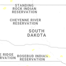
South Dakota
| Local Time | Report Details |
|---|---|
| 3:39 PM MDT | Quarter sized hail reported near Hermosa, SD, 11.9 miles S of Rapid City, SD |
| 4:58 PM MDT | Quarter sized hail reported near Sturgis, SD, 27.1 miles NNW of Rapid City, SD |
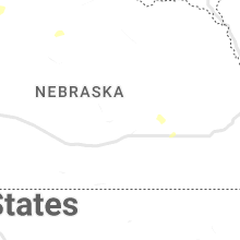
Nebraska
| Local Time | Report Details |
|---|---|
| 4:50 PM MDT | Mesonet station fw8225 sidne in cheyenne county NE, 60.6 miles SSE of Scottsbluff, NE |
| 6:00 PM MDT | Quarter sized hail reported near Chadron, NE, 66.1 miles NNE of Scottsbluff, NE, chadron state park employee reports approximately 15 mins of hail...largest hail sizes reported over the phone were nickel to quarter sized. |
| 7:30 PM CDT | Reported via social media. gusts of 60 mph continued over a duration of 15 minute in red willow county NE, 59.5 miles NNE of Colby, KS |
| 7:30 PM CDT | Sustained at 54 mp in red willow county NE, 61.1 miles NNE of Colby, KS |
| 7:48 PM CDT | Corrects previous non-tstm wnd gst report from 2 e mccook. asos station kmck mccook airpor in red willow county NE, 60.7 miles NNE of Colby, KS |
Wyoming
| Local Time | Report Details |
|---|---|
| 5:45 PM MDT | Half Dollar sized hail reported near Newcastle, WY, 48.9 miles W of Rapid City, SD |
| 6:10 PM MDT | Quarter sized hail reported near Upton, WY, 38 miles SE of Gillette, WY |
| 6:20 PM MDT | Quarter sized hail reported near Newcastle, WY, 58.7 miles SE of Gillette, WY |
| 6:27 PM MDT | Ping Pong Ball sized hail reported near Newcastle, WY, 57.3 miles SE of Gillette, WY, time estimated via radar |
| 7:00 PM MDT | Quarter sized hail reported near Newcastle, WY, 50.7 miles WSW of Rapid City, SD |
| 8:15 PM MDT | Quarter sized hail reported near Sundance, WY, 52.7 miles WNW of Rapid City, SD |
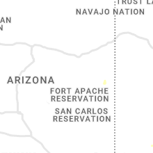
Arizona
| Local Time | Report Details |
|---|---|
| 5:27 PM MST | Two trees uprooted at city hal in santa cruz county AZ, 60.1 miles S of Tucson, AZ |
Texas
| Local Time | Report Details |
|---|---|
| 7:34 PM CDT | Storm damage reported in cochran county TX, 51.8 miles W of Lubbock, TX |
Iowa
| Local Time | Report Details |
|---|---|
| 8:25 PM CDT | Quarter sized hail reported near Elkader, IA, 56.3 miles NNE of Cedar Rapids, IA |
| 8:30 PM CDT | One tree dow in clayton county IA, 55.6 miles NNE of Cedar Rapids, IA |
| 8:30 PM CDT | Quarter sized hail reported near Garber, IA, 56.6 miles NNE of Cedar Rapids, IA |
Connect with Interactive Hail Maps