

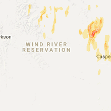
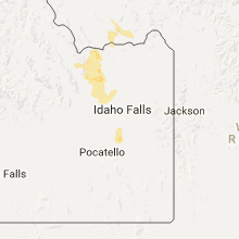
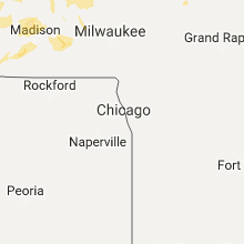
Hail Map for Monday, June 12, 2017

Number of Impacted Households on 6/12/2017
0
Impacted by 1" or Larger Hail
0
Impacted by 1.75" or Larger Hail
0
Impacted by 2.5" or Larger Hail
Square Miles of Populated Area Impacted on 6/12/2017
0
Impacted by 1" or Larger Hail
0
Impacted by 1.75" or Larger Hail
0
Impacted by 2.5" or Larger Hail


Cities Most Affected by Hail Storms of 6/12/2017
| Hail Size | Demographics of Zip Codes Affected | ||||||
|---|---|---|---|---|---|---|---|
| City | Count | Average | Largest | Pop Density | House Value | Income | Age |
| Wheatland, WY | 7 | 3.43 | 4.50 | 3 | $89k | $35.1k | 47.3 |
| Cheyenne, WY | 5 | 2.70 | 2.75 | 44 | $119k | $46.8k | 39.1 |
| Plainview, TX | 4 | 2.69 | 3.00 | 68 | $57k | $31.5k | 31.2 |
| Grover, CO | 4 | 2.31 | 3.00 | 0 | $74k | $22.7k | 47.9 |
| Douglas, WY | 3 | 2.58 | 4.00 | 3 | $88k | $39.7k | 38.0 |
| Fort Laramie, WY | 3 | 2.42 | 2.75 | 1 | $57k | $26.9k | 52.0 |
| Pierce, CO | 2 | 3.38 | 4.25 | 13 | $108k | $39.9k | 39.3 |
| Fort Collins, CO | 3 | 2.08 | 2.75 | 433 | $220k | $61.7k | 35.3 |
| Pine Bluffs, WY | 2 | 3.00 | 3.00 | 2 | $82k | $33.5k | 44.0 |
| Alliance, NE | 2 | 2.63 | 2.75 | 10 | $73k | $39.4k | 40.8 |
| Freeman, SD | 2 | 1.75 | 1.75 | 5 | $52k | $31.0k | 47.7 |
| Torrington, WY | 1 | 2.75 | 2.75 | 13 | $79k | $33.0k | 43.0 |
| Kaycee, WY | 1 | 2.50 | 2.50 | 0 | $67k | $35.9k | 44.4 |
| Floydada, TX | 1 | 2.00 | 2.00 | 7 | $35k | $25.8k | 38.1 |
| Windsor, CO | 1 | 2.00 | 2.00 | 416 | $160k | $54.1k | 37.1 |
| Ault, CO | 1 | 1.75 | 1.75 | 8 | $121k | $36.5k | 37.0 |
| Odessa, TX | 1 | 1.75 | 1.75 | 1265 | $58k | $35.7k | 31.7 |
| Angora, NE | 1 | 1.75 | 1.75 | 1 | $48k | $28.9k | 49.8 |
Hail and Wind Damage Spotted on 6/12/2017
Filter by Report Type:Hail ReportsWind Reports
States Impacted
Nebraska, South Dakota, Iowa, Idaho, Minnesota, Colorado, Georgia, Maine, Wisconsin, Wyoming, Texas, Montana, MichiganNebraska
| Local Time | Report Details |
|---|---|
| 7:15 AM CDT | Ping Pong Ball sized hail reported near Lincoln, NE, 54.4 miles SW of Omaha, NE, crop damage due to estimated ping pong ball sized hail |
| 7:20 AM CDT | Ping Pong Ball sized hail reported near Lincoln, NE, 52.6 miles SW of Omaha, NE, report via facebook |
| 7:21 AM CDT | Quarter sized hail reported near Lincoln, NE, 52.6 miles SW of Omaha, NE, reported via mping |
| 8:47 AM CDT | Quarter sized hail reported near Avoca, NE, 35.9 miles SSW of Omaha, NE, hail up to quarter size. |
| 7:03 PM MDT | Quarter sized hail reported near Gering, NE, 12.6 miles S of Scottsbluff, NE |
| 7:03 PM MDT | Half Dollar sized hail reported near Gering, NE, 9.3 miles SE of Scottsbluff, NE, quarter to half dollar hail |
| 7:15 PM MDT | Trees and power lines down in bayard. time based on rada in morrill county NE, 19.1 miles ESE of Scottsbluff, NE |
| 7:15 PM MDT | Trees and power lines down. time based on rada in morrill county NE, 19.6 miles E of Scottsbluff, NE |
| 7:56 PM MDT | Quarter sized hail reported near Rushville, NE, 79.4 miles NE of Scottsbluff, NE |
| 8:00 PM MDT | Golf Ball sized hail reported near Angora, NE, 36.5 miles ENE of Scottsbluff, NE, near the morrill-box butte county line. |
| 8:10 PM MDT | Quarter sized hail reported near Alliance, NE, 44 miles ENE of Scottsbluff, NE, kansas st in alliance. |
| 8:15 PM MDT | Baseball sized hail reported near Alliance, NE, 44 miles ENE of Scottsbluff, NE |
| 8:18 PM MDT | Tennis Ball sized hail reported near Alliance, NE, 44 miles ENE of Scottsbluff, NE, report received via facebook. |
South Dakota
| Local Time | Report Details |
|---|---|
| 9:35 AM CDT | Ping Pong Ball sized hail reported near Irene, SD, 45.8 miles SW of Sioux Falls, SD |
| 9:42 AM CDT | Quarter sized hail reported near Freeman, SD, 38.4 miles SW of Sioux Falls, SD |
| 9:48 AM CDT | Golf Ball sized hail reported near Freeman, SD, 38.4 miles SW of Sioux Falls, SD |
| 9:57 AM CDT | Golf Ball sized hail reported near Freeman, SD, 37.6 miles WSW of Sioux Falls, SD |
| 10:40 AM CDT | Quarter sized hail reported near Menno, SD, 48 miles WSW of Sioux Falls, SD |
| 11:13 AM CDT | Quarter sized hail reported near Lennox, SD, 11.3 miles SSW of Sioux Falls, SD |
| 7:10 PM MDT | Quarter sized hail reported near Oelrichs, SD, 65 miles S of Rapid City, SD |
| 7:15 PM MDT | Estimated nickel sized hail in oglala lakota county SD, 62.6 miles S of Rapid City, SD |
| 7:40 PM MDT | Quarter sized hail reported near Smithwick, SD, 53.2 miles S of Rapid City, SD |
| 7:43 PM MDT | Quarter sized hail reported near Smithwick, SD, 53.2 miles S of Rapid City, SD |
| 8:44 PM MDT | Quarter sized hail reported near Buffalo Gap, SD, 46.7 miles SE of Rapid City, SD |
| 9:00 PM MDT | Quarter sized hail reported near Buffalo Gap, SD, 46.7 miles SE of Rapid City, SD |
| 9:20 PM MDT | Storm damage reported in oglala lakota county SD, 71.6 miles SE of Rapid City, SD |
| 1:19 AM CDT | 71 mph at pierre airpor in hughes county SD, 1.7 miles ENE of Pierre, SD |
| 1:53 AM CDT | 59 mph at mobridge airpor in walworth county SD, 81 miles N of Pierre, SD |
| 3:27 AM CDT | Storm damage reported in brown county SD, 7.5 miles W of Aberdeen, SD |
| 3:29 AM CDT | Storm damage reported in brown county SD, 8.7 miles NW of Aberdeen, SD |
| 3:45 AM CDT | Some tree limbs down in aberdee in brown county SD, 0.8 miles NNE of Aberdeen, SD |
| 3:50 AM CDT | Quarter sized hail reported near Aberdeen, SD, 0.8 miles NNE of Aberdeen, SD |
Iowa
| Local Time | Report Details |
|---|---|
| 11:27 AM CDT | Trained spotter reported heavy damage to corn and bean fields likely from hail... power lines down across the road... and numerous tree branches down. this is a delayed in palo alto county IA, 42.7 miles NNE of Storm Lake, IA |
| 3:50 PM CDT | Quarter sized hail reported near Scranton, IA, 53.9 miles WNW of Des Moines, IA |
| 4:09 PM CDT | Quarter sized hail reported near Jefferson, IA, 49.4 miles NW of Des Moines, IA, dime to quarter size hail. |
Idaho
| Local Time | Report Details |
|---|---|
| 10:48 AM MDT | Quarter sized hail reported near Shelley, ID, 12 miles S of Idaho Falls, ID, photo of quarter size hail in goshen shared by idaho falls magazine facebook page. time estimated based on radar. |
| 10:51 AM MDT | Quarter sized hail reported near Shelley, ID, 8.7 miles SSW of Idaho Falls, ID, photo of multiple hail stones to quarter size... or slightly larger than quarter size... from the public in shelley via social media. time estimated based on radar. |
| 10:51 AM MDT | Half Dollar sized hail reported near Shelley, ID, 8.7 miles SSW of Idaho Falls, ID, photo of quarter size to slightly larger than half dollar size hail shared on the east idaho news facebook page. multiple reports of at least quarter size hail from thi |
| 10:52 AM MDT | Ping Pong Ball sized hail reported near Shelley, ID, 8.7 miles SSW of Idaho Falls, ID, time estimated based on radar. shared on east idaho news facebook page. |
| 10:58 AM MDT | Quarter sized hail reported near Idaho Falls, ID, 1.8 miles SSW of Idaho Falls, ID, reported at smith honda. shared via social media with kifi local news 8. time estimated based on radar. |
| 11:00 AM MDT | Half Dollar sized hail reported near Idaho Falls, ID, 0.7 miles NW of Idaho Falls, ID, reported on landbank street. time estimated based on radar. photo shared by the public on the east idaho news facebook page. |
| 11:01 AM MDT | Ping Pong Ball sized hail reported near Idaho Falls, ID, 0.9 miles W of Idaho Falls, ID, ping pong ball size hail reported on the west side of idaho falls. time estimated based on radar. |
| 11:01 AM MDT | Quarter sized hail reported near Idaho Falls, ID, 0.8 miles NE of Idaho Falls, ID |
| 11:01 AM MDT | Half Dollar sized hail reported near Idaho Falls, ID, 0.2 miles SE of Idaho Falls, ID, numerous public reports of nickel... quarter... and half dollar size hail in idaho falls... especially across the western half of the city. hail lightly covered the gro |
| 11:05 AM MDT | Quarter sized hail reported near Idaho Falls, ID, 0.2 miles SE of Idaho Falls, ID, reported at the arl frd office in idaho falls. time estimated based on radar. |
| 11:23 AM MDT | Quarter sized hail reported near Roberts, ID, 16.3 miles NNW of Idaho Falls, ID, time estimated based on radar. shared with east idaho news on facebook. |
Minnesota
| Local Time | Report Details |
|---|---|
| 12:55 PM CDT | Power lines down on the east side of ambo in blue earth county MN, 70 miles NW of Mason City, IA |
| 12:55 PM CDT | Several trees down and uprooted at the intersection of county roads 10 and 2 in blue earth county MN, 76.6 miles NW of Mason City, IA |
| 1:20 PM CDT | Mesonet station mn039... waseca 1ss in waseca county MN, 64.4 miles S of Minneapolis, MN |
| 1:24 PM CDT | Measured at the waseca airpor in waseca county MN, 64.3 miles SSW of Minneapolis, MN |
| 1:30 PM CDT | Multiple limbs down in tow in waseca county MN, 63.2 miles S of Minneapolis, MN |
| 1:38 PM CDT | Tree down on hwy 4 in steele county MN, 54.5 miles S of Minneapolis, MN |
| 1:48 PM CDT | Measured at faribault airpor in rice county MN, 45.6 miles S of Minneapolis, MN |
| 2:22 PM CDT | Measured near century high schoo in olmsted county MN, 61 miles WNW of La Crosse, WI |
| 2:28 PM CDT | Nine inch tree uproote in olmsted county MN, 67.3 miles WNW of La Crosse, WI |
| 2:40 PM CDT | Quarter sized hail reported near Chatfield, MN, 46.9 miles W of La Crosse, WI, relay via broadcast media. gust 50 mph. |
| 6:25 AM CDT | Storm damage reported in big stone county MN, 56.4 miles NW of Montevideo, MN |
Colorado
| Local Time | Report Details |
|---|---|
| 2:15 PM MDT | Half Dollar sized hail reported near Loveland, CO, 46.2 miles N of Denver, CO |
| 2:26 PM MDT | Quarter sized hail reported near Loveland, CO, 46.9 miles N of Denver, CO |
| 2:28 PM MDT | Golf Ball sized hail reported near Fort Collins, CO, 51.1 miles N of Denver, CO |
| 2:30 PM MDT | Golf Ball sized hail reported near Fort Collins, CO, 53.2 miles N of Denver, CO |
| 2:32 PM MDT | Hen Egg sized hail reported near Windsor, CO, 51.9 miles N of Denver, CO |
| 3:18 PM MDT | Quarter sized hail reported near Nunn, CO, 59.7 miles SE of Laramie, WY |
| 3:24 PM MDT | Quarter sized hail reported near Wellington, CO, 54.1 miles SE of Laramie, WY |
| 3:25 PM MDT | Quarter sized hail reported near Wellington, CO, 54.1 miles SE of Laramie, WY |
| 3:38 PM MDT | Tennis Ball sized hail reported near Pierce, CO, 60.3 miles SE of Laramie, WY |
| 3:43 PM MDT | Quarter sized hail reported near Nunn, CO, 59.7 miles SE of Laramie, WY |
| 3:45 PM MDT | Baseball sized hail reported near Fort Collins, CO, 59.5 miles SE of Laramie, WY |
| 3:59 PM MDT | Half Dollar sized hail reported near Nunn, CO, 63.6 miles SE of Laramie, WY |
| 4:00 PM MDT | Grapefruit sized hail reported near Pierce, CO, 62.7 miles NNE of Denver, CO |
| 4:01 PM MDT | Golf Ball sized hail reported near Ault, CO, 67.1 miles SE of Laramie, WY |
| 4:35 PM MDT | Tea Cup sized hail reported near Grover, CO, 71.7 miles SSW of Scottsbluff, NE |
| 4:40 PM MDT | Golf Ball sized hail reported near Grover, CO, 68.3 miles ESE of Laramie, WY |
| 4:40 PM MDT | Ping Pong Ball sized hail reported near Grover, CO, 69.9 miles SSW of Scottsbluff, NE |
| 4:47 PM MDT | Golf Ball sized hail reported near Grover, CO, 68 miles SSW of Scottsbluff, NE |
| 4:48 PM MDT | Baseball sized hail reported near Grover, CO, 69.9 miles SSW of Scottsbluff, NE, funnel cloud |
Georgia
| Local Time | Report Details |
|---|---|
| 4:45 PM EDT | Several large trees down and other tree damage between creekwood circle and allatoona lan in cobb county GA, 23.5 miles NW of Atlanta, GA |
Maine
| Local Time | Report Details |
|---|---|
| 4:46 PM EDT | Trees and power lines down...putnam ave...north st... rte 1 in houlton in aroostook county ME, 51 miles S of Caribou, ME |
| 5:44 PM EDT | Tree down lake r in penobscot county ME, 62.1 miles N of Bangor, ME |
| 5:45 PM EDT | Around 3000 homes and businesses without power in the millinocket and medway are in penobscot county ME, 59.3 miles N of Bangor, ME |
| 5:45 PM EDT | Smith pond. trees down across driveway in penobscot county ME, 60.7 miles N of Bangor, ME |
| 5:48 PM EDT | Several trees down near millinocket in penobscot county ME, 59.3 miles N of Bangor, ME |
Wisconsin
| Local Time | Report Details |
|---|---|
| 3:50 PM CDT | Report of tree damage from galesville to ettric in trempealeau county WI, 19.1 miles NNW of La Crosse, WI |
| 3:51 PM CDT | Tree dow in trempealeau county WI, 30.5 miles NNW of La Crosse, WI |
| 3:54 PM CDT | Large tree limbs down and some trees uprooted. largest tree approximately 20 inches in diameter. time estimated from rada in trempealeau county WI, 26.5 miles N of La Crosse, WI |
| 4:00 PM CDT | Reports of trees/power lines down in south la cross in la crosse county WI, 1.1 miles SE of La Crosse, WI |
| 4:23 PM CDT | Quarter sized hail reported near Wautoma, WI, 64.8 miles WSW of Green Bay, WI |
| 4:38 PM CDT | Bleachers blown over at baseball field. report relayed via broadcast media. time estimated from rada in jackson county WI, 40.2 miles NE of La Crosse, WI |
| 4:40 PM CDT | Power lines dow in jackson county WI, 32.7 miles NE of La Crosse, WI |
| 4:40 PM CDT | Power lines dow in jackson county WI, 32.7 miles NE of La Crosse, WI |
| 5:05 PM CDT | Storm damage reported in juneau county WI, 49.7 miles E of La Crosse, WI |
| 5:30 PM CDT | Small trees down. time estimate in wood county WI, 71.1 miles NE of La Crosse, WI |
| 6:09 PM CDT | Trees down in portage county WI, 75.6 miles W of Green Bay, WI |
| 6:13 PM CDT | Trees down on homes... power outages... 1.92 inches of rain since 530 p in portage county WI, 75.3 miles W of Green Bay, WI |
| 6:30 PM CDT | Numerous trees down throughout the county... except for the sw sid in marquette county WI, 49.6 miles N of Madison, WI |
| 6:41 PM CDT | In village of princeton... treetops snapped off and trees dow in green lake county WI, 55.9 miles NNE of Madison, WI |
| 6:45 PM CDT | A 12 inch diameter tree was snapped off in the 400 block of jackson s in fond du lac county WI, 51.6 miles NE of Madison, WI |
| 6:46 PM CDT | 0.5 miles east of randolph estimated 60 mph winds. 12 inch diameter tree dow in dodge county WI, 37.7 miles NNE of Madison, WI |
| 6:50 PM CDT | Estimated 70 mph winds. falling tree in fond du lac county WI, 55.5 miles NNE of Madison, WI |
| 6:50 PM CDT | Half of roof shingles blown of in fond du lac county WI, 50.9 miles NE of Madison, WI |
| 6:52 PM CDT | Trees down on powerlines in the town of black wol in winnebago county WI, 47.1 miles SSW of Green Bay, WI |
| 7:00 PM CDT | 6 inch to 12 inch diameter tree limbs dow in dodge county WI, 52.3 miles NE of Madison, WI |
| 7:01 PM CDT | 0.2 miles east of juneau estimated 60 mph wind in dodge county WI, 42.2 miles NE of Madison, WI |
| 7:03 PM CDT | Street flooding in the cit in waupaca county WI, 37.1 miles W of Green Bay, WI |
| 7:06 PM CDT | 12 inch diameter tree limb down. estimated 65 mph win in dodge county WI, 59.6 miles NE of Madison, WI |
| 7:06 PM CDT | 6 inch diameter tree limb dow in dodge county WI, 59.2 miles NE of Madison, WI |
| 7:08 PM CDT | Many tree branches down 0.5 miles sw of beaver da in dodge county WI, 37.6 miles NE of Madison, WI |
| 7:20 PM CDT | Numerous trees and power lines down across washington county. time estimated from rada in washington county WI, 66 miles ENE of Madison, WI |
| 7:20 PM CDT | Numerous fallen trees in kewaskum. some roads blocke in washington county WI, 66.4 miles ENE of Madison, WI |
| 7:24 PM CDT | Downed power lines 1.4 miles southeast of burnet in dodge county WI, 45.9 miles NE of Madison, WI |
| 7:25 PM CDT | Power is out 0.3 miles east of mayvill in dodge county WI, 52.3 miles NE of Madison, WI |
| 7:28 PM CDT | Measured 61 mph at mayville/horicon marsh raws sit in dodge county WI, 52 miles NE of Madison, WI |
| 7:30 PM CDT | Horse trailer knocked dow in washington county WI, 63.6 miles ENE of Madison, WI |
| 7:30 PM CDT | Quarter sized hail reported near Hartford, WI, 53.2 miles ENE of Madison, WI |
| 7:41 PM CDT | A few trees down in the kiel area. time estimated via rada in manitowoc county WI, 41.6 miles S of Green Bay, WI |
| 7:42 PM CDT | Trees and power lines dow in calumet county WI, 39 miles S of Green Bay, WI |
| 7:44 PM CDT | Storm damage reported in calumet county WI, 34.2 miles SSW of Green Bay, WI |
| 7:45 PM CDT | A few trees down on the west side of town. time estimated via rada in brown county WI, 0.5 miles ESE of Green Bay, WI |
| 7:45 PM CDT | Quarter sized hail reported near Plymouth, WI, 52.7 miles S of Green Bay, WI |
| 7:45 PM CDT | 2-3 ft diameter tree dow in fond du lac county WI, 61.5 miles SSW of Green Bay, WI |
| 7:46 PM CDT | Tree down in calumet county WI, 40.1 miles SSW of Green Bay, WI |
| 8:06 PM CDT | Trees down in the cleveland area. time estimated via rada in manitowoc county WI, 43.6 miles SSE of Green Bay, WI |
| 8:06 PM CDT | Several trees down in the city of manitowoc. time estimated via rada in manitowoc county WI, 34.6 miles SSE of Green Bay, WI |
| 8:13 PM CDT | Several trees down in the city of manitowoc. time estimated via radar. corrected for tim in manitowoc county WI, 34.6 miles SSE of Green Bay, WI |
| 8:20 PM CDT | 2 reports of trees down. one north of highway 33 in saukville... and one south of highway 33 in grafton. report relayed via ham radi in ozaukee county WI, 76 miles ENE of Madison, WI |
| 8:31 PM CDT | Measured at racine reef automated senso in lmz646 county WI, 58.6 miles N of Chicago, IL |
| 8:36 PM CDT | Measured at racine reef automated senso in lmz646 county WI, 58.6 miles N of Chicago, IL |
| 10:00 PM CDT | Numerous trees and power lines down throughout city. some trees uprooted and other snapped off. at least 1 tree greater than 12 inch diameter. trees on cars. city works in dodge county WI, 50.7 miles NE of Madison, WI |
Wyoming
| Local Time | Report Details |
|---|---|
| 3:11 PM MDT | Quarter sized hail reported near Wheatland, WY, 57.4 miles NE of Laramie, WY |
| 3:13 PM MDT | Quarter sized hail reported near Wheatland, WY, 60.5 miles NNE of Laramie, WY |
| 3:14 PM MDT | Grapefruit sized hail reported near Wheatland, WY, 60 miles NNE of Laramie, WY |
| 3:15 PM MDT | Hen Egg sized hail reported near Wheatland, WY, 56.8 miles NE of Laramie, WY |
| 3:21 PM MDT | Hen Egg sized hail reported near Wheatland, WY, 60.5 miles NNE of Laramie, WY |
| 3:23 PM MDT | Baseball sized hail reported near Wheatland, WY, 60.5 miles NNE of Laramie, WY |
| 3:25 PM MDT | Softball sized hail reported near Wheatland, WY, 60.5 miles NNE of Laramie, WY |
| 3:25 PM MDT | Grapefruit sized hail reported near Wheatland, WY, 58.2 miles NNE of Laramie, WY |
| 3:30 PM MDT | Grapefruit sized hail reported near Wheatland, WY, 57.4 miles NE of Laramie, WY |
| 3:46 PM MDT | Ping Pong Ball sized hail reported near Douglas, WY, 51.1 miles E of Casper, WY, car dents and broken house windows. |
| 3:50 PM MDT | Golf Ball sized hail reported near Douglas, WY, 48.1 miles E of Casper, WY, quarter to golf ball sized hail estimated. |
| 3:50 PM MDT | Baseball sized hail reported near Cheyenne, WY, 39.6 miles ESE of Laramie, WY, golf ball to base ball hail lasted five minutes. |
| 4:00 PM MDT | Baseball sized hail reported near Cheyenne, WY, 42.1 miles E of Laramie, WY, on trinidad ct east of yellowstone rd. |
| 4:00 PM MDT | Ping Pong Ball sized hail reported near Manderson, WY, 88.5 miles NNE of Riverton, WY, nickle to a few ping pong ball sized hail observed near manderson. |
| 4:01 PM MDT | Tennis Ball sized hail reported near Cheyenne, WY, 39.6 miles ESE of Laramie, WY, on fe warren |
| 4:01 PM MDT | Baseball sized hail reported near Cheyenne, WY, 43 miles ESE of Laramie, WY, laramie county em wife reporting baseball hail at 107 trinidad court in cheyenne |
| 4:10 PM MDT | Hen Egg sized hail reported near Fort Laramie, WY, 50.2 miles WNW of Scottsbluff, NE |
| 4:12 PM MDT | Ping Pong Ball sized hail reported near Cheyenne, WY, 41.7 miles E of Laramie, WY |
| 4:15 PM MDT | Baseball sized hail reported near Cheyenne, WY, 44.1 miles E of Laramie, WY, golf ball to baseball hail at 8600 block of powderhouse rd. |
| 4:19 PM MDT | Tennis Ball sized hail reported near Fort Laramie, WY, 50.2 miles WNW of Scottsbluff, NE |
| 4:25 PM MDT | Baseball sized hail reported near Fort Laramie, WY, 50.2 miles WNW of Scottsbluff, NE, time based on radar. |
| 5:05 PM MDT | Grapefruit sized hail reported near Douglas, WY, 50.9 miles ESE of Casper, WY |
| 5:13 PM MDT | Ping Pong Ball sized hail reported near Kaycee, WY, 63.2 miles NNW of Casper, WY, quarter to golf ball sized hail. |
| 5:14 PM MDT | Ping Pong Ball sized hail reported near Gillette, WY, 41.9 miles SSW of Gillette, WY |
| 5:15 PM MDT | Quarter sized hail reported near Gillette, WY, 39.1 miles SSW of Gillette, WY |
| 5:20 PM MDT | Hen Egg sized hail reported near Douglas, WY, 50.1 miles E of Casper, WY |
| 5:26 PM MDT | Baseball sized hail reported near Torrington, WY, 44.8 miles NW of Scottsbluff, NE, golf ball to baseball. |
| 5:27 PM MDT | Tennis Ball sized hail reported near Kaycee, WY, 59.1 miles NNW of Casper, WY, golf ball to tennis ball sized hail. |
| 5:30 PM MDT | Tea Cup sized hail reported near Pine Bluffs, WY, 51.6 miles SSW of Scottsbluff, NE, time based on radar. |
| 5:33 PM MDT | Tea Cup sized hail reported near Pine Bluffs, WY, 51.6 miles SSW of Scottsbluff, NE |
| 5:34 PM MDT | Quarter sized hail reported near Kaycee, WY, 61.4 miles NNW of Casper, WY |
| 6:05 PM MDT | Quarter sized hail reported near Evansville, WY, 3.7 miles ENE of Casper, WY |
| 6:15 PM MDT | Half Dollar sized hail reported near Casper, WY, 3.5 miles ESE of Casper, WY |
| 6:30 PM MDT | Quarter sized hail reported near Glenrock, WY, 23.3 miles E of Casper, WY |
| 6:42 PM MDT | Mesonet station recorded a wind gust to 68 mp in fremont county WY, 27.1 miles WSW of Riverton, WY |
| 7:20 PM MDT | Quarter sized hail reported near Ten Sleep, WY, 86 miles NE of Riverton, WY |
| 8:05 PM MDT | Storm damage reported in sheridan county WY, 79.5 miles WNW of Gillette, WY |
Texas
| Local Time | Report Details |
|---|---|
| 6:14 PM CDT | Storm damage reported in ector county TX, 5.7 miles NE of Odessa, TX |
| 6:18 PM CDT | Quarter sized hail reported near Odessa, TX, 3.4 miles S of Odessa, TX, also 1 inch tree limbs downed. |
| 6:21 PM CDT | Golf Ball sized hail reported near Odessa, TX, 3.5 miles N of Odessa, TX |
| 6:23 PM CDT | Tree branch down approx. 8in in diamete in midland county TX, 13.8 miles NE of Odessa, TX |
| 6:23 PM CDT | Half Dollar sized hail reported near Midland, TX, 10.3 miles E of Odessa, TX |
| 6:25 PM CDT | Quarter sized hail reported near Midland, TX, 10.3 miles E of Odessa, TX |
| 6:31 PM CDT | Storm damage reported in midland county TX, 13.8 miles NE of Odessa, TX |
| 6:35 PM CDT | Quarter sized hail reported near Midland, TX, 13.8 miles NE of Odessa, TX, at nws midland/odessa |
| 6:43 PM CDT | Storm damage reported in midland county TX, 19.5 miles NE of Odessa, TX |
| 7:08 PM CDT | Baseball sized hail reported near Plainview, TX, 41.1 miles N of Lubbock, TX, time estimated. extent of damage unknown at this time. |
| 7:08 PM CDT | Hen Egg sized hail reported near Plainview, TX, 41.9 miles N of Lubbock, TX, time estimated from radar. |
| 7:08 PM CDT | Tea Cup sized hail reported near Plainview, TX, 43.6 miles N of Lubbock, TX, time estimated from radar. |
| 7:11 PM CDT | Quarter sized hail reported near Plainview, TX, 41.9 miles N of Lubbock, TX |
| 8:30 PM CDT | Tea Cup sized hail reported near Plainview, TX, 28.2 miles NNE of Lubbock, TX |
| 9:43 PM CDT | Hen Egg sized hail reported near Floydada, TX, 33.3 miles NE of Lubbock, TX, falling at this time. mostly golf ball size. |
| 9:50 PM CDT | Sustained 53 mph. earlier gust to 58 mph at 948 pm. measured by the west texas mesone in hale county TX, 40.5 miles NNE of Lubbock, TX |
| 9:50 PM CDT | Sustained 53 mph. earlier gust to 58 mph at 948 pm. measured by the west texas mesone in hale county TX, 40.5 miles NNE of Lubbock, TX |
| 9:55 PM CDT | Measured by the west texas mesone in floyd county TX, 41.3 miles NE of Lubbock, TX |
Montana
| Local Time | Report Details |
|---|---|
| 5:36 PM MDT | Storm damage reported in park county MT, 28.3 miles E of Bozeman, MT |
| 6:22 PM MDT | Quarter sized hail reported near Bridger, MT, 41.4 miles SW of Billings, MT, social media report. |
| 7:28 PM MDT | Power lines down in harlowton in wheatland county MT, 77.8 miles NE of Bozeman, MT |
| 8:03 PM MDT | Quarter sized hail reported near Vaughn, MT, 12 miles WNW of Great Falls, MT, trained spotter reports quarter sized hail... along with 30 to 35mph wind gusts. |
| 8:46 PM MDT | Storm damage reported in fergus county MT, 91.9 miles ESE of Great Falls, MT |
| 8:55 PM MDT | Storm damage reported in fergus county MT, 76.5 miles NNW of Billings, MT |
| 9:59 PM MDT | Tree damage reported around miles city with trees up to 18 inches in diameter snapped of in custer county MT, 2.5 miles NW of Miles City, MT |
Michigan
| Local Time | Report Details |
|---|---|
| 11:36 PM EDT | Tree down on s. garfield rd. near sharkey rd. time estimate in grand traverse county MI, 6.8 miles SSE of Traverse City, MI |
| 1:03 AM EDT | Mesonet station mmom4... mi in oscoda county MI, 42.7 miles SW of Alpena, MI |
| 1:15 AM EDT | Trees down on a hous in ogemaw county MI, 55.4 miles SW of Alpena, MI |
Connect with Interactive Hail Maps