

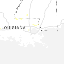
Hail Map for Thursday, June 16, 2022

Number of Impacted Households on 6/16/2022
0
Impacted by 1" or Larger Hail
0
Impacted by 1.75" or Larger Hail
0
Impacted by 2.5" or Larger Hail
Square Miles of Populated Area Impacted on 6/16/2022
0
Impacted by 1" or Larger Hail
0
Impacted by 1.75" or Larger Hail
0
Impacted by 2.5" or Larger Hail


Cities Most Affected by Hail Storms of 6/16/2022
| Hail Size | Demographics of Zip Codes Affected | ||||||
|---|---|---|---|---|---|---|---|
| City | Count | Average | Largest | Pop Density | House Value | Income | Age |
| Lincoln, NE | 6 | 1.83 | 2.00 | 1357 | $102k | $42.2k | 29.0 |
| Transfer, PA | 3 | 1.83 | 2.00 | 113 | $89k | $35.2k | 45.8 |
| Fredonia, PA | 2 | 2.13 | 2.50 | 60 | $65k | $39.7k | 40.4 |
| Malcolm, NE | 2 | 1.75 | 1.75 | 31 | $103k | $52.0k | 42.2 |
| Seward, NE | 2 | 1.75 | 1.75 | 50 | $96k | $44.3k | 35.5 |
| Farmington, NY | 2 | 1.75 | 1.75 | 617 | $94k | $49.2k | 36.4 |
| Port Washington, OH | 1 | 2.75 | 2.75 | 34 | $67k | $31.7k | 39.8 |
| Cato, NY | 1 | 2.50 | 2.50 | 52 | $76k | $43.0k | 41.6 |
| Chardon, OH | 1 | 1.75 | 1.75 | 256 | $182k | $56.2k | 44.0 |
| Keeling, VA | 1 | 1.75 | 1.75 | 40 | $66k | $27.9k | 43.4 |
| Victor, NY | 1 | 1.75 | 1.75 | 357 | $140k | $58.4k | 42.2 |
| Strasburg, OH | 1 | 1.75 | 1.75 | 229 | $96k | $37.6k | 43.0 |
| Chester Gap, VA | 1 | 1.75 | 1.75 | 554 | $0k | $0.0k | 39.9 |
| Beach City, OH | 1 | 1.75 | 1.75 | 94 | $77k | $37.8k | 39.8 |
Hail and Wind Damage Spotted on 6/16/2022
Filter by Report Type:Hail ReportsWind Reports
States Impacted
Michigan, North Carolina, Virginia, Georgia, Ohio, South Carolina, New York, Pennsylvania, West Virginia, Louisiana, Missouri, Mississippi, Vermont, Florida, Alabama, Texas, Kansas, Nebraska, Colorado, New Mexico, Illinois, WyomingMichigan
| Local Time | Report Details |
|---|---|
| 8:10 AM EDT | Multiple trees down reported across green oak township. additional trees down reported in hambur in livingston county MI, 36 miles S of Flint, MI |
| 8:17 AM EDT | Multiple trees down at the walnut creek country club. time estimated by rada in oakland county MI, 37.8 miles S of Flint, MI |
North Carolina
| Local Time | Report Details |
|---|---|
| 1:18 PM EDT | Quarter sized hail reported near Marion, NC, 63.9 miles NNE of Greenville, SC, reported on nix creek rd. in sugar hill area. |
| 1:38 PM EDT | Quarter sized hail reported near Marion, NC, 62.8 miles S of Bristol, TN, pleasant gardens area. |
| 1:38 PM EDT | Trees down in pleasant gardens are in mcdowell county NC, 62.1 miles S of Bristol, TN |
| 2:26 PM EDT | 2 trees down. time estimated from rada in surry county NC, 74.1 miles N of Charlotte, NC |
| 2:26 PM EDT | 5 trees dow in surry county NC, 74.2 miles N of Charlotte, NC |
| 2:30 PM EDT | Tree down on hwy 704. time estimated from rada in stokes county NC, 52.8 miles SSW of Roanoke, VA |
| 2:30 PM EDT | Thunderstorm winds blew down a tree which took down powerlines on rockford roa in surry county NC, 73.6 miles N of Charlotte, NC |
| 2:34 PM EDT | Tree down on king roa in stokes county NC, 62.1 miles SSW of Roanoke, VA |
| 2:47 PM EDT | Trees down from millspring to rutherford county lin in polk county NC, 44.4 miles NE of Greenville, SC |
| 2:49 PM EDT | Tree down on nc hwy 770. time estimated from rada in stokes county NC, 54.2 miles S of Roanoke, VA |
| 3:09 PM EDT | Partially rotten large oak tree blown dow in stokes county NC, 60.4 miles S of Roanoke, VA |
| 3:09 PM EDT | One tree down due to the thunderstorm winds along the 1700 block of ayersville roa in rockingham county NC, 58.1 miles S of Roanoke, VA |
| 3:14 PM EDT | One tree down due to thunderstorm winds along cheney loop roa in rockingham county NC, 56 miles S of Roanoke, VA |
| 3:19 PM EDT | A tree down blocking the road near the intersection of windswept drive and crossing ridge drive. time estimated by rada in forsyth county NC, 70.7 miles S of Roanoke, VA |
| 3:20 PM EDT | Trees down in spencer and in east spence in rowan county NC, 38.7 miles NE of Charlotte, NC |
| 3:26 PM EDT | One tree down due to thunderstorm winds along mccollum roa in rockingham county NC, 63 miles S of Roanoke, VA |
| 3:28 PM EDT | One tree down due to thunderstorm winds at the intersection of new lebanon church road and nc highway 6 in rockingham county NC, 63.9 miles S of Roanoke, VA |
| 3:30 PM EDT | Numerous reports of trees and power lines down throughout the county. reports still coming in as of 4:15 p in rockingham county NC, 61.8 miles S of Roanoke, VA |
| 3:34 PM EDT | Quarter sized hail reported near Dobson, NC, 76.6 miles N of Charlotte, NC, quarter sized hail near the intersection of nc hwy 268 and route 601. |
| 3:35 PM EDT | One tree down due to thunderstorm winds along wendy oak roa in rockingham county NC, 69.4 miles S of Roanoke, VA |
| 3:38 PM EDT | One tree down due to thunderstorm winds along the 100 block of woolen store roa in rockingham county NC, 68.9 miles S of Roanoke, VA |
| 3:39 PM EDT | Multiple trees down due to thunderstorm winds along sandy cross roa in rockingham county NC, 63.2 miles S of Roanoke, VA |
| 3:40 PM EDT | One tree down due to thunderstorm winds along church street extensio in rockingham county NC, 70.2 miles S of Roanoke, VA |
| 3:40 PM EDT | One tree down due to thunderstorm winds along meadow branch roa in rockingham county NC, 68.5 miles S of Roanoke, VA |
| 3:42 PM EDT | Multiple trees down reported throughout providence... n in caswell county NC, 61.9 miles SSE of Roanoke, VA |
| 3:43 PM EDT | One tree down due to thunderstorm winds near the intersection of spearmen road and cunningham mill roa in rockingham county NC, 69.5 miles WNW of Raleigh, NC |
| 3:44 PM EDT | Trees and power lines down. widespread tree damage across southern rowan... northern cabarrus... and central cabarrus countie in cabarrus county NC, 18.7 miles NE of Charlotte, NC |
| 3:48 PM EDT | Trees dow in rowan county NC, 37.7 miles NNE of Charlotte, NC |
| 3:49 PM EDT | Quarter sized hail reported near Kannapolis, NC, 21.9 miles NE of Charlotte, NC |
| 3:54 PM EDT | Tree down on nc hwy 86 near the caswell farmers marke in caswell county NC, 59 miles NW of Raleigh, NC |
| 3:55 PM EDT | Fallen trees causing power outages in downtown greensbor in guilford county NC, 67.8 miles WNW of Raleigh, NC |
| 4:01 PM EDT | Emergency management confirmed trees and powerlines down county-wide. some areas include mcleansville... greensboro... pleasant garden... and forest oak in guilford county NC, 66.7 miles WNW of Raleigh, NC |
| 4:04 PM EDT | Fallen trees caused power outages at robertson rd and rolling creek d in person county NC, 48.7 miles NNW of Raleigh, NC |
| 4:14 PM EDT | Large tree down on house along hwy 16 south of newto in catawba county NC, 33.2 miles NNW of Charlotte, NC |
| 4:30 PM EDT | Tree down on old 60 hwy near ronda n in wilkes county NC, 67.3 miles N of Charlotte, NC |
| 4:30 PM EDT | Fallen trees causing power outages on piney grove church r in chatham county NC, 47 miles W of Raleigh, NC |
| 4:36 PM EDT | Fallen trees causing power outages on randolph church rd and holder farm r in randolph county NC, 57.4 miles W of Raleigh, NC |
| 4:37 PM EDT | Tree down near intersection of fishing creek rd and lw anderson r in wilkes county NC, 66.1 miles NNW of Charlotte, NC |
| 4:37 PM EDT | Tree down on fishing creek r in wilkes county NC, 66.2 miles NNW of Charlotte, NC |
| 4:41 PM EDT | Multiple trees down on the southside of yadkinville n in yadkin county NC, 63.4 miles N of Charlotte, NC |
| 4:45 PM EDT | Quarter sized hail reported near Charlotte, NC, 4 miles SE of Charlotte, NC, quarter size hail in cotswold area. |
| 4:49 PM EDT | Tree down on cedar forest r in wilkes county NC, 66.2 miles N of Charlotte, NC |
| 4:53 PM EDT | Fallen trees caused power outages in downtown pittsboro as well as to the north and wes in chatham county NC, 30.5 miles W of Raleigh, NC |
| 4:53 PM EDT | Corrects previous tstm wnd dmg report from 1 se oakboro. several trees down in the area of oakboro. time estimated by rada in stanly county NC, 29.9 miles E of Charlotte, NC |
| 4:59 PM EDT | A tree fell on a car (damaging it) in the jordan lake are in chatham county NC, 23.6 miles W of Raleigh, NC |
| 5:03 PM EDT | Tree across lincoln street in cramerto in gaston county NC, 12.3 miles WNW of Charlotte, NC |
| 5:12 PM EDT | Trees down county wid in union county NC, 23.3 miles SE of Charlotte, NC |
| 5:13 PM EDT | Several reports of trees down around the city of peachland. time estimated by rada in anson county NC, 35.9 miles ESE of Charlotte, NC |
| 5:21 PM EDT | Several reports of downed trees around the city of polkton. time estimated by rada in anson county NC, 39 miles ESE of Charlotte, NC |
| 5:25 PM EDT | Tree down at spence farm rd and olde mckenzie dr in holly spring in wake county NC, 16 miles SW of Raleigh, NC |
| 5:28 PM EDT | Trees down county wid in union county NC, 31 miles SE of Charlotte, NC |
| 5:29 PM EDT | Report of a tree down in the city of ansonville blocking the roadway. time estimated by rada in anson county NC, 42 miles ESE of Charlotte, NC |
| 5:48 PM EDT | Tree down at lake wheeler rd and s saunders st in raleig in wake county NC, 1.1 miles SSW of Raleigh, NC |
| 5:48 PM EDT | Tree down at renfrow rd and parkland r in wake county NC, 2.5 miles S of Raleigh, NC |
| 5:48 PM EDT | Tree down at the 1000 block of s person st in downtown raleig in wake county NC, 1.1 miles S of Raleigh, NC |
| 5:50 PM EDT | Power line down at the 2000 block of poole r in wake county NC, 1.9 miles ESE of Raleigh, NC |
| 5:52 PM EDT | Tree down at the 700 block of belmont dr in raleig in wake county NC, 2.6 miles ESE of Raleigh, NC |
| 5:52 PM EDT | Tree down at cross link rd and hadley r in wake county NC, 2.8 miles SSE of Raleigh, NC |
| 6:00 PM EDT | Power pole on tree... resulting in an electrical fir in montgomery county NC, 60.5 miles E of Charlotte, NC |
| 6:00 PM EDT | Tree on road at sedberry rd and cedar creek r in montgomery county NC, 59.2 miles E of Charlotte, NC |
| 6:01 PM EDT | Several reports of trees down near the city of wadesboro. time estimated by rada in anson county NC, 46.3 miles ESE of Charlotte, NC |
| 6:05 PM EDT | Power pole on tree... resulting in an electrical fir in montgomery county NC, 60.5 miles E of Charlotte, NC |
| 6:05 PM EDT | Tree on road at sedberry rd and cedar creek r in montgomery county NC, 59.2 miles E of Charlotte, NC |
| 6:05 PM EDT | Tree down at mccaskill r in montgomery county NC, 59.7 miles E of Charlotte, NC |
| 6:08 PM EDT | Tree and power pole down at cabin creek rd and post office r in montgomery county NC, 62.1 miles E of Charlotte, NC |
| 6:08 PM EDT | Tree on road at ballpark rd and us highway 220 alt in montgomery county NC, 61.2 miles E of Charlotte, NC |
| 6:11 PM EDT | Tree on road at w ewing st and w main st in cando in montgomery county NC, 61.7 miles E of Charlotte, NC |
| 6:14 PM EDT | Tree blocking road at cole rd and brewer r in montgomery county NC, 63.5 miles E of Charlotte, NC |
| 6:18 PM EDT | Tree down on nc highway 211 near the moore/montgomery county lin in montgomery county NC, 64 miles E of Charlotte, NC |
| 6:30 PM EDT | Numerous trees and power lines down throughout richmond count in richmond county NC, 63.3 miles ESE of Charlotte, NC |
| 6:50 PM EDT | Numerous trees and power lines down throughout scotland count in scotland county NC, 80.5 miles SW of Raleigh, NC |
Virginia
| Local Time | Report Details |
|---|---|
| 1:47 PM EDT | Tree down blocking one lane of road. near intersection of fair oaks drive and henry street in stanleytown v in henry county VA, 36 miles S of Roanoke, VA |
| 2:00 PM EDT | Thunderstorm winds blew a tree down on pioneer trai in henry county VA, 37.4 miles S of Roanoke, VA |
| 2:13 PM EDT | Tree down in the road... blocking one lane on appalachian drive. also tree on powerline. before fieldale bridge... near intersection of brandon rd and daniels creek r in henry county VA, 39.4 miles S of Roanoke, VA |
| 2:16 PM EDT | Tree down in the 100 block of naff road. time estimated from rada in franklin county VA, 9 miles SSW of Roanoke, VA |
| 2:20 PM EDT | A business on coleman lane reported at least one large tree blown down by thunderstorm winds and several large branches dow in patrick county VA, 49.9 miles S of Roanoke, VA |
| 2:20 PM EDT | Thunderstorm winds blew down a tree near the intersection of carver road and creekside driv in henry county VA, 40.1 miles S of Roanoke, VA |
| 3:04 PM EDT | Tree on powerline on hickory forest r in pittsylvania county VA, 50.5 miles SSE of Roanoke, VA |
| 3:10 PM EDT | Tree down on mount view rd near blairs v in pittsylvania county VA, 49.8 miles SE of Roanoke, VA |
| 3:20 PM EDT | Tree on vehicle. time estimated from rada in city of danville county VA, 52.6 miles SSE of Roanoke, VA |
| 3:22 PM EDT | Trees and power lines down in the 3300 block of old richmond r in pittsylvania county VA, 53.5 miles SE of Roanoke, VA |
| 3:24 PM EDT | Golf Ball sized hail reported near Keeling, VA, 52.4 miles SE of Roanoke, VA, from picture relayed by wdbj7. time estimated from radar. |
| 3:25 PM EDT | Tree on house. time estimated from rada in city of danville county VA, 54.3 miles SE of Roanoke, VA |
| 3:26 PM EDT | Tree and power lines down. time estimated from rada in city of danville county VA, 54.2 miles SSE of Roanoke, VA |
| 3:28 PM EDT | Tree on power lin in city of danville county VA, 55.8 miles SE of Roanoke, VA |
| 3:28 PM EDT | Tree and power line down. time estimated from rada in city of danville county VA, 54.6 miles SE of Roanoke, VA |
| 3:30 PM EDT | Tree down on lime plant roa in appomattox county VA, 60.6 miles ENE of Roanoke, VA |
| 3:32 PM EDT | Tree on power line. time estimated from rada in city of danville county VA, 54 miles SE of Roanoke, VA |
| 3:36 PM EDT | Tree down. time estimated from rada in appomattox county VA, 63.7 miles W of Richmond, VA |
| 3:38 PM EDT | Tree on powerline in the 2900 block of south boston hw in pittsylvania county VA, 60.8 miles SE of Roanoke, VA |
| 3:38 PM EDT | Tree down on rocksprings roa in pittsylvania county VA, 57.9 miles SE of Roanoke, VA |
| 3:50 PM EDT | Tree down near hummingbird lan in halifax county VA, 58.3 miles SE of Roanoke, VA |
| 3:52 PM EDT | Ping Pong Ball sized hail reported near Huntly, VA, 86.7 miles WSW of Baltimore, MD |
| 3:54 PM EDT | Golf Ball sized hail reported near Chester Gap, VA, 87.7 miles WSW of Baltimore, MD |
| 4:02 PM EDT | Tree down. time estimated from rada in campbell county VA, 41.5 miles ESE of Roanoke, VA |
| 4:02 PM EDT | Tree down. time estimated from rada in campbell county VA, 39.7 miles ESE of Roanoke, VA |
| 4:20 PM EDT | Trees blew down in loudon county on northbound va-651 gap road near us-15 james monroe highwa in loudoun county VA, 56.7 miles WSW of Baltimore, MD |
| 4:20 PM EDT | Tree uprooted on bellevue r in halifax county VA, 67.1 miles NNW of Raleigh, NC |
| 4:25 PM EDT | A tree blew down near blue ridge mountain rd and john mosby hw in clarke county VA, 74.9 miles WSW of Baltimore, MD |
| 4:31 PM EDT | A tree blew down near frogtown rd and providence l in clarke county VA, 74.2 miles W of Baltimore, MD |
| 4:31 PM EDT | A tree blew down near frogtown rd and providence l in clarke county VA, 72.5 miles WSW of Baltimore, MD |
| 4:38 PM EDT | Tree down on edgewood lan in charlotte county VA, 63.4 miles WSW of Richmond, VA |
| 4:40 PM EDT | Numerous trees down across the count in charlotte county VA, 62.5 miles WSW of Richmond, VA |
| 4:41 PM EDT | Tree down on george washington highwa in charlotte county VA, 59.5 miles WSW of Richmond, VA |
| 4:43 PM EDT | Tree down on va 92... kings highwa in charlotte county VA, 72 miles N of Raleigh, NC |
| 4:43 PM EDT | Tree down on colemans ferry r in charlotte county VA, 70.8 miles SW of Richmond, VA |
| 4:47 PM EDT | Tree down on jackson vaughn r in charlotte county VA, 69.1 miles SW of Richmond, VA |
| 4:49 PM EDT | Tree down on barnesville highwa in charlotte county VA, 70.5 miles SW of Richmond, VA |
| 4:53 PM EDT | Tree down on moody creek r in charlotte county VA, 67.4 miles SW of Richmond, VA |
| 5:18 PM EDT | Quarter sized hail reported near Boston, VA, 76.5 miles NNW of Richmond, VA |
| 5:19 PM EDT | Quarter sized hail reported near Boston, VA, 75.3 miles NNW of Richmond, VA |
| 5:38 PM EDT | A tree blew down onto power lines near opal rd and south pines r in fauquier county VA, 79.1 miles N of Richmond, VA |
| 5:43 PM EDT | A tree blew down near the 11200 block of st paul's r in fauquier county VA, 74.3 miles N of Richmond, VA |
| 5:54 PM EDT | Numerous trees blew down along the corridor of james madison hwy... zachary taylor hwy and rapidan r in culpeper county VA, 67.7 miles NNW of Richmond, VA |
| 6:06 PM EDT | Tree blew down on plank road near constitution highwa in orange county VA, 57.2 miles N of Richmond, VA |
| 6:10 PM EDT | Trees down ellisville d in louisa county VA, 44.7 miles NNW of Richmond, VA |
| 6:11 PM EDT | Tree down in the 900 block of locust grove church r in madison county VA, 61.6 miles NNW of Richmond, VA |
| 6:11 PM EDT | Tree down at the intersection of tatums school rd. and locust grove church r in madison county VA, 60.2 miles NNW of Richmond, VA |
| 6:11 PM EDT | Tree down along wrights l in madison county VA, 62.2 miles NNW of Richmond, VA |
| 6:12 PM EDT | Tree down in the 2000 block of celt r in greene county VA, 69.1 miles NW of Richmond, VA |
| 6:25 PM EDT | Multiple reports of trees down in the city of orang in orange county VA, 57.3 miles NNW of Richmond, VA |
| 6:25 PM EDT | Half Dollar sized hail reported near Orange, VA, 57.3 miles NNW of Richmond, VA |
| 6:35 PM EDT | Trees down kennen r in louisa county VA, 36.6 miles NNW of Richmond, VA |
| 6:35 PM EDT | Half Dollar sized hail reported near Mineral, VA, 37.7 miles NNW of Richmond, VA, elizabeth trice walton park. |
| 6:45 PM EDT | Quarter sized hail reported near Orange, VA, 51.7 miles NNW of Richmond, VA |
| 6:55 PM EDT | Trees down mt airy r in louisa county VA, 36.6 miles NNW of Richmond, VA |
| 7:02 PM EDT | Baseball stands and fencing significantly damage in louisa county VA, 37.7 miles NNW of Richmond, VA |
| 7:55 PM EDT | 2 trees downed onto a structur in goochland county VA, 21.7 miles NW of Richmond, VA |
| 8:10 PM EDT | Numerous trees dow in powhatan county VA, 11.4 miles NW of Richmond, VA |
| 8:15 PM EDT | Numerous trees dow in powhatan county VA, 8.1 miles NW of Richmond, VA |
| 8:25 PM EDT | Power outage in goochland county VA, 17 miles NW of Richmond, VA |
| 9:38 PM EDT | Tree down in dublin on rt 10 in pulaski county VA, 43.2 miles WSW of Roanoke, VA |
| 9:46 PM EDT | One tree down due to thunderstorm winds along fairview church roa in montgomery county VA, 31.7 miles WSW of Roanoke, VA |
| 9:48 PM EDT | Multiple trees reported down due to thunderstorm winds along route 8 from riner to floy in montgomery county VA, 30.9 miles WSW of Roanoke, VA |
| 9:48 PM EDT | Several trees down along childress r in montgomery county VA, 33.4 miles WSW of Roanoke, VA |
| 9:48 PM EDT | Tree down on state park rd near claytor lak in pulaski county VA, 40.3 miles WSW of Roanoke, VA |
| 9:52 PM EDT | One tree down due to thunderstorm winds along union valley roa in montgomery county VA, 29.4 miles WSW of Roanoke, VA |
| 9:52 PM EDT | Tree down on owens r in pulaski county VA, 41.8 miles WSW of Roanoke, VA |
| 11:22 PM EDT | Large tree dow in alleghany county VA, 31.5 miles N of Roanoke, VA |
| 11:50 PM EDT | A tree down as well as power line in halifax county VA, 65.9 miles NNW of Raleigh, NC |
| 11:51 PM EDT | Tree dow in city of covington county VA, 35.2 miles N of Roanoke, VA |
| 11:52 PM EDT | Power lines dow in halifax county VA, 62.9 miles ESE of Roanoke, VA |
| 12:23 AM EDT | Tree dow in alleghany county VA, 37.5 miles N of Roanoke, VA |
| 12:57 AM EDT | Tree down at shadwell drive and waterfall driv in roanoke county VA, 5.4 miles N of Roanoke, VA |
| 12:59 AM EDT | Tree dow in roanoke county VA, 2.8 miles ENE of Roanoke, VA |
| 1:00 AM EDT | One tree down on poor farm roa in botetourt county VA, 18.4 miles NNE of Roanoke, VA |
| 1:11 AM EDT | Tree dow in roanoke county VA, 5.5 miles NNE of Roanoke, VA |
| 1:15 AM EDT | A few trees down in stewartsville... along route 24 and also goodview roa in bedford county VA, 7.7 miles E of Roanoke, VA |
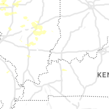
Georgia
| Local Time | Report Details |
|---|---|
| 2:15 PM EDT | Quarter sized hail reported near Lakemont, GA, 46.7 miles W of Greenville, SC |
| 9:38 PM EDT | Ping Pong Ball sized hail reported near Atlanta, GA, 13.3 miles N of Atlanta, GA, walnut sized hail observed at abernathy and glenridge rd |
| 9:53 PM EDT | Quarter sized hail reported near Atlanta, GA, 12.5 miles N of Atlanta, GA, quarter sized hail reported via social media in sandy springs near roswell rd |
| 11:00 PM EDT | Half Dollar sized hail reported near Powder Springs, GA, 17.6 miles WNW of Atlanta, GA, quarter to golf ball size hail |
| 11:05 PM EDT | 3 large trees down in paulding county GA, 21.7 miles WNW of Atlanta, GA |
| 11:05 PM EDT | Numerous trees down in paulding county GA, 24.5 miles W of Atlanta, GA |
| 11:05 PM EDT | *** 1 inj *** 1 tree down on a car in paulding county GA, 23.7 miles W of Atlanta, GA |
Ohio
| Local Time | Report Details |
|---|---|
| 2:40 PM EDT | Quarter sized hail reported near Chardon, OH, 26.5 miles E of Cleveland, OH, quarter sized hail near aquilla rd and mayfield rd. |
| 2:42 PM EDT | Golf Ball sized hail reported near Chardon, OH, 25.7 miles E of Cleveland, OH, golf ball sized hail. |
| 2:47 PM EDT | A few trees down in the burton area. time estimated from rada in geauga county OH, 28.1 miles E of Cleveland, OH |
| 2:47 PM EDT | Numerous trees and wires down on butternut road in burton. also a house fire on the burton square possibly related to lightning. time estimated from rada in geauga county OH, 28 miles E of Cleveland, OH |
| 2:55 PM EDT | Several trees and wires down in smithville... new pittsburg... and s of wooster. time estimated from rada in wayne county OH, 44.7 miles SSW of Cleveland, OH |
| 3:18 PM EDT | Golf Ball sized hail reported near Beach City, OH, 58.4 miles S of Cleveland, OH, estimated golf ball sized hail. time estimated via radar. |
| 3:24 PM EDT | Numerous trees and powerlines down in the ne part of the count in holmes county OH, 59.1 miles S of Cleveland, OH |
| 3:26 PM EDT | Report of wind damage to a churc in stark county OH, 59.2 miles S of Cleveland, OH |
| 3:33 PM EDT | Quarter sized hail reported near Fowler, OH, 58.7 miles ESE of Cleveland, OH, delayed report - quarter inch hail. |
| 3:34 PM EDT | Half Dollar sized hail reported near Strasburg, OH, 63 miles S of Cleveland, OH |
| 3:35 PM EDT | Golf Ball sized hail reported near Strasburg, OH, 63 miles S of Cleveland, OH |
| 3:37 PM EDT | Tree down across n. crater ave. near e. 7th street in tuscarawas county OH, 68.1 miles S of Cleveland, OH |
| 3:38 PM EDT | One tree snapped in the jeffco lakes part of andover. time estimated from rada in ashtabula county OH, 54.1 miles E of Cleveland, OH |
| 3:45 PM EDT | Report of multiple trees down around dover. damage not considered excessiv in tuscarawas county OH, 68.1 miles S of Cleveland, OH |
| 3:45 PM EDT | Power lines down in tuscarawas county OH, 63.4 miles S of Cleveland, OH |
| 3:53 PM EDT | Numerous trees and powerlines down in mt. vernon and danville. a transformer was also on fire in mt. vernon. time estimated from rada in knox county OH, 40.6 miles NE of Columbus, OH |
| 4:00 PM EDT | Quarter sized hail reported near Dover, OH, 68.1 miles S of Cleveland, OH |
| 4:04 PM EDT | Quarter sized hail reported near Sherrodsville, OH, 65.6 miles W of Pittsburgh, PA |
| 4:12 PM EDT | Report of multiple trees and power lines down in the are in coshocton county OH, 75 miles ENE of Columbus, OH |
| 4:16 PM EDT | Multiple trees and powerlines down in mesopotamia. route 534 is closed south of route 87. time estimated from rada in trumbull county OH, 38 miles E of Cleveland, OH |
| 4:17 PM EDT | Large tree limbs/branches down (greater than 2 inches) in carroll county OH, 66.1 miles W of Pittsburgh, PA |
| 4:26 PM EDT | Ping Pong Ball sized hail reported near Port Washington, OH, 80.7 miles W of Pittsburgh, PA |
| 4:26 PM EDT | Baseball sized hail reported near Port Washington, OH, 80.7 miles W of Pittsburgh, PA, em passing along report of estimated baseball size hail. |
| 4:33 PM EDT | Numerous trees and wires down in the ne portion of trumbull county. time estimated from rada in trumbull county OH, 57.6 miles E of Cleveland, OH |
| 4:36 PM EDT | Half Dollar sized hail reported near Jewett, OH, 53.1 miles W of Pittsburgh, PA |
| 4:39 PM EDT | Report of multiple trees and power lines down in the are in coshocton county OH, 69.9 miles ENE of Columbus, OH |
| 4:51 PM EDT | Tree damage along window road reported to ema by residents in guernsey county OH, 74.7 miles ENE of Columbus, OH |
| 4:52 PM EDT | Ping Pong Ball sized hail reported near Tippecanoe, OH, 74 miles W of Pittsburgh, PA |
| 5:00 PM EDT | A number of trees dow in tuscarawas county OH, 76.8 miles W of Pittsburgh, PA |
| 5:00 PM EDT | Quarter sized hail reported near Tippecanoe, OH, 72.3 miles W of Pittsburgh, PA |
| 5:11 PM EDT | Quarter sized hail reported near Cadiz, OH, 64.1 miles WSW of Pittsburgh, PA |
| 5:20 PM EDT | Trees down on mt hermon road and beeham run road both near cambridge via county dispatch in guernsey county OH, 72.8 miles E of Columbus, OH |
| 5:27 PM EDT | Report of tree down on old national road. time estimated based on rada in belmont county OH, 69.7 miles WSW of Pittsburgh, PA |
| 5:36 PM EDT | Quarter sized hail reported near Barnesville, OH, 69.3 miles WSW of Pittsburgh, PA |
| 5:45 PM EDT | Quarter sized hail reported near Bethesda, OH, 64 miles WSW of Pittsburgh, PA |
| 5:55 PM EDT | Trees down on old national road in belmont county OH, 69.7 miles WSW of Pittsburgh, PA |
| 6:01 PM EDT | Quarter sized hail reported near Quaker City, OH, 75.9 miles WSW of Pittsburgh, PA |
| 7:18 PM EDT | Damage to outbuilding observed from thunderstorm win in monroe county OH, 84.5 miles SW of Pittsburgh, PA |
| 7:18 PM EDT | Quarter sized hail reported near Stafford, OH, 84.5 miles SW of Pittsburgh, PA |
| 7:30 PM EDT | Half Dollar sized hail reported near Graysville, OH, 82.1 miles SW of Pittsburgh, PA, range of sizes from dime to half dollar accompanied by very strong wind |
| 7:32 PM EDT | Ping Pong Ball sized hail reported near Graysville, OH, 81.8 miles SW of Pittsburgh, PA |
| 7:38 PM EDT | Tree dow in morgan county OH, 73 miles ESE of Columbus, OH |
| 8:01 PM EDT | Some trees down near thurston. measured 43 mph wind with a hand-held anemomete in fairfield county OH, 26 miles ESE of Columbus, OH |
| 9:50 PM EDT | Corrects previous tstm wnd dmg report from lower salem. multiple trees down across the are in washington county OH, 84.5 miles N of Charleston, WV |
| 10:15 PM EDT | Multiple trees down across the are in washington county OH, 84.5 miles N of Charleston, WV |
South Carolina
| Local Time | Report Details |
|---|---|
| 2:40 PM EDT | Trees uprooted along townsend driv in pickens county SC, 0.6 miles E of Greenville, SC |
| 3:18 PM EDT | Trees down at this location and 12 other locations around the northeast quadrant of spartanburg count in spartanburg county SC, 42 miles ENE of Greenville, SC |
| 3:28 PM EDT | Tree dow in spartanburg county SC, 47.1 miles ENE of Greenville, SC |
| 3:40 PM EDT | Multiple power lines down along highway 150 in gaffne in cherokee county SC, 48.6 miles WSW of Charlotte, NC |
| 3:45 PM EDT | Trees dow in cherokee county SC, 50.3 miles WSW of Charlotte, NC |
| 4:03 PM EDT | Trees down county wide... some on house in cherokee county SC, 46.6 miles WSW of Charlotte, NC |
| 4:03 PM EDT | Trees down in jonesvill in union county SC, 52.3 miles E of Greenville, SC |
| 4:14 PM EDT | Trees down in mcconnell in york county SC, 32.9 miles SW of Charlotte, NC |
| 4:14 PM EDT | Trees down in sharo in york county SC, 34.1 miles WSW of Charlotte, NC |
| 4:19 PM EDT | Trees down city of buffal in union county SC, 52.8 miles E of Greenville, SC |
| 4:30 PM EDT | Trees and power lines down county wid in chester county SC, 44.5 miles SW of Charlotte, NC |
| 4:50 PM EDT | Newberry county sheriff reported trees down along shingle mill rd at piester r in newberry county SC, 63.6 miles NNE of Augusta, GA |
| 4:51 PM EDT | Trees and power lines down county wid in chester county SC, 34.5 miles SSW of Charlotte, NC |
| 5:02 PM EDT | Large tree fell on traveling truck 1.5 miles north of harmony baptist churc in york county SC, 28.9 miles SSW of Charlotte, NC |
| 5:10 PM EDT | Fairfield county dispatch reported trees down along hwy 200 near i-7 in fairfield county SC, 50 miles S of Charlotte, NC |
| 5:10 PM EDT | Fairfield county dispatch reported large uprooted trees at the intersection of patrick and 321 in white oak. time estimated by rada in fairfield county SC, 53.6 miles SSW of Charlotte, NC |
| 5:10 PM EDT | County dispatch reported trees and power lines down at multiple locations in the county with widespread power outages along collins rd due to lines dow in lancaster county SC, 18.8 miles S of Charlotte, NC |
| 5:28 PM EDT | Sc highway patrol reported trees down along cedar grove rd at hwy in lexington county SC, 45.6 miles NE of Augusta, GA |
| 5:31 PM EDT | County dispatch reported trees on power lines along baltic circl in fairfield county SC, 67.3 miles SSW of Charlotte, NC |
| 5:33 PM EDT | Sc highway patrol reported tree in roadway at the intersection of craig farm rd. and montgomery rd. time estimated by rada in lancaster county SC, 32.1 miles S of Charlotte, NC |
| 5:50 PM EDT | Sc highway patrol reports trees down on veterans row and sessions r in kershaw county SC, 70.5 miles S of Charlotte, NC |
| 5:59 PM EDT | Dispatch reported numerous trees down along bethune rd near bethun in kershaw county SC, 61.9 miles SSE of Charlotte, NC |
| 6:00 PM EDT | Sc highway patrol reported trees down at crane church and slab pile road. time estimated by rada in richland county SC, 68.7 miles NE of Augusta, GA |
| 6:00 PM EDT | Sc highway patrol reported tree in the roadway at the intersection of old creek rd. and us 1. time estimated by rada in chesterfield county SC, 62.6 miles SSE of Charlotte, NC |
| 6:06 PM EDT | Dispatch reports numerous trees down along hwy 1 in lugoff which took down powerline in kershaw county SC, 69 miles S of Charlotte, NC |
| 6:09 PM EDT | Sc highway patrol reported tree blocking the roadway at the intersection of browning rd. and zimalcrest dr. time estimated by rada in richland county SC, 63.1 miles NE of Augusta, GA |
| 6:10 PM EDT | Sc highway patrol reported tree in the roadway at the intersection of williamsburg dr. and coronado dr. time estimated by rada in richland county SC, 64.5 miles NE of Augusta, GA |
| 6:10 PM EDT | Sc highway patrol reported tree in the roadway at the intersection of riverhill cir. and broad river rd. time estimated by rada in richland county SC, 63.6 miles NE of Augusta, GA |
| 6:14 PM EDT | Dispatch reports trees down along lakeshore d in kershaw county SC, 67.8 miles SSE of Charlotte, NC |
| 6:15 PM EDT | Sc highway patrol reported trees down at battleford road and emerald valley road. time estimate in richland county SC, 64 miles NE of Augusta, GA |
| 6:16 PM EDT | Sc highway patrol reports trees down on surrey st at magrath s in richland county SC, 66.8 miles NE of Augusta, GA |
| 6:18 PM EDT | Sc highway patrol reported trees down along hwy 52 at belton r in chesterfield county SC, 60.4 miles ESE of Charlotte, NC |
| 6:22 PM EDT | Corrects previous tstm wnd dmg report from 2 nw red bank. sc highway patrol reported trees down and roadway blocked at wildlife road and wildlife circle. time estimated in lexington county SC, 52.9 miles NE of Augusta, GA |
| 6:23 PM EDT | Tree down across us 15 near the railroad avenue cross sectio in darlington county SC, 73.9 miles SE of Charlotte, NC |
| 6:24 PM EDT | Columbia fire reports multiple collapsed structures along downing st in columbi in richland county SC, 67.8 miles ENE of Augusta, GA |
| 6:26 PM EDT | Sc highway patrol reports trees down along i-77 near ft jackso in richland county SC, 69.8 miles ENE of Augusta, GA |
| 6:26 PM EDT | County dispatch reported trees down along columbia highway at shiloh church r in aiken county SC, 22 miles NE of Augusta, GA |
| 6:30 PM EDT | Numerous trees and powerlines down across southeast chesterfield c in chesterfield county SC, 62.9 miles SE of Charlotte, NC |
| 6:34 PM EDT | Tree in roadway on old creek rd and us1. 911 call cente in chesterfield county SC, 62.3 miles SSE of Charlotte, NC |
| 6:46 PM EDT | Tree across southborough road near the intersection of century driv in florence county SC, 68.3 miles N of Charleston, SC |
| 6:50 PM EDT | Sc highway patrol reported trees down and roadway blocked at trinity road and mcknight road. time estimate in sumter county SC, 54.8 miles N of Charleston, SC |
| 6:52 PM EDT | Tree down on horrace matthews road near the intersection of poor farm roa in florence county SC, 64 miles NNE of Charleston, SC |
| 7:00 PM EDT | Sc highway patrol reports trees down along i-95 sb at mm13 in clarendon county SC, 46.1 miles N of Charleston, SC |
| 7:02 PM EDT | Sc highway patrol reports trees down on megan ct at strawberry l in richland county SC, 65 miles NW of Charleston, SC |
| 7:03 PM EDT | Sc highway patrol reported tree in the roadway on live oak rd. time estimated by rada in sumter county SC, 64.8 miles NNW of Charleston, SC |
| 7:03 PM EDT | Tree down across north bethel road near the intersection of west camp branch roa in florence county SC, 50.5 miles NNE of Charleston, SC |
| 7:04 PM EDT | The public reported several trees down in olanta and provided video of damage to a large-diameter tree that was spli in florence county SC, 51.5 miles N of Charleston, SC |
| 7:05 PM EDT | Sc highway patrol reported trees down at lewis road and deejay lane. time estimate in sumter county SC, 51.2 miles NNW of Charleston, SC |
| 7:18 PM EDT | Dispatch reports trees down along ranchero st at snipes pond r in aiken county SC, 25.2 miles ENE of Augusta, GA |
| 7:22 PM EDT | Sc highway patrol reported trees down and roadway blocked at wildlife road and wildlife circle. time estimate in lexington county SC, 52.9 miles NE of Augusta, GA |
| 7:25 PM EDT | Sc highway patrol reported trees down in roadway with all lanes blocked. time estimated by rada in clarendon county SC, 44 miles N of Charleston, SC |
| 7:35 PM EDT | Sc highway patrol reported trees down at cameron road and mccords ferry road. time estimated by rada in calhoun county SC, 45.2 miles NW of Charleston, SC |
| 7:59 PM EDT | Tree reported down at the intersection of highway 35 and russellville road. time estimated by rada in berkeley county SC, 14.2 miles N of Charleston, SC |
| 8:00 PM EDT | Sc highway patrol reported tree down on i95 at mile marker 87sb. time estimate in orangeburg county SC, 31.9 miles WNW of Charleston, SC |
| 8:00 PM EDT | Sc highway patrol reported trees down on i95 at mile marker 88sb. time estimate in orangeburg county SC, 32 miles WNW of Charleston, SC |
| 8:19 PM EDT | Sc highway patrol reported a tree on homestead rd. before the bowman town limit. time estimated by rada in orangeburg county SC, 40.2 miles WNW of Charleston, SC |
| 8:20 PM EDT | Tree down on powerlines at gravel hill road and harristown roa in berkeley county SC, 12.2 miles NE of Charleston, SC |
| 8:31 PM EDT | Sc highway patrol reports a tree down at the intersection of augusta highway and jefferies highway. time estimated by radar. damage due to thunderstorm outflo in colleton county SC, 36.4 miles WSW of Charleston, SC |
| 8:32 PM EDT | Tree down at 401 n. live oak roa in berkeley county SC, 0.9 miles ESE of Charleston, SC |
| 8:45 PM EDT | Tree down on powerlines at gravel hill road and harristown roa in berkeley county SC, 12.2 miles NE of Charleston, SC |
| 8:46 PM EDT | Tree down at 401 n. live oak roa in berkeley county SC, 0.9 miles ESE of Charleston, SC |
| 8:48 PM EDT | Tree reported down on bates branch road at brewer road. time estimated from rada in dorchester county SC, 16.7 miles SW of Charleston, SC |
| 9:08 PM EDT | Tree down in road at treeland drive and lobloll in berkeley county SC, 13.8 miles SSW of Charleston, SC |
| 9:15 PM EDT | Tree in roadway at river road and trucklands road. time estimated from rada in charleston county SC, 34.9 miles S of Charleston, SC |
New York
| Local Time | Report Details |
|---|---|
| 2:58 PM EDT | Corrects previous tstm wnd dmg report from 4 sw chautauqua. tree took down wires on hewes r in chautauqua county NY, 59 miles SSW of Buffalo, NY |
| 3:30 PM EDT | Tree dow in niagara county NY, 28.1 miles N of Buffalo, NY |
| 3:37 PM EDT | Ping Pong Ball sized hail reported near Chaffee, NY, 30.7 miles SE of Buffalo, NY |
| 3:38 PM EDT | Quarter sized hail reported near Chaffee, NY, 30.3 miles SE of Buffalo, NY |
| 3:42 PM EDT | Tree dow in niagara county NY, 29.4 miles NNE of Buffalo, NY |
| 3:50 PM EDT | *** 1 inj *** damage to mobile homes... including two completely destroyed. 1 minor injury reporte in cayuga county NY, 34 miles NW of Syracuse, NY |
| 3:58 PM EDT | Tree took down wires on hewes r in chautauqua county NY, 59 miles SSW of Buffalo, NY |
| 4:00 PM EDT | Quarter sized hail reported near Red Creek, NY, 31.5 miles WNW of Syracuse, NY |
| 4:00 PM EDT | Tennis Ball sized hail reported near Cato, NY, 27.2 miles WNW of Syracuse, NY |
| 4:00 PM EDT | Trees and wires down in victor in cayuga county NY, 27.4 miles WNW of Syracuse, NY |
| 4:04 PM EDT | Quarter sized hail reported near Perry, NY, 45.6 miles ESE of Buffalo, NY |
| 4:08 PM EDT | Trees and wires down in conques in cayuga county NY, 25.9 miles W of Syracuse, NY |
| 4:12 PM EDT | Two large trees dow in livingston county NY, 54.7 miles E of Buffalo, NY |
| 4:12 PM EDT | Tree dow in orleans county NY, 43.5 miles NE of Buffalo, NY |
| 4:15 PM EDT | Several trees blown down along/near rt 20a in genese in livingston county NY, 55.6 miles E of Buffalo, NY |
| 4:17 PM EDT | Several trees down in lakeville are in livingston county NY, 59.9 miles E of Buffalo, NY |
| 4:24 PM EDT | Part of the livonia school roof damage in livingston county NY, 61.5 miles E of Buffalo, NY |
| 4:35 PM EDT | Multiple trees dow in jefferson county NY, 36.8 miles SSW of Ogdensburg, NY |
| 4:35 PM EDT | Trees and powerlines down along willard roa in st. lawrence county NY, 28.7 miles ENE of Ogdensburg, NY |
| 4:36 PM EDT | Quarter sized hail reported near Cato, NY, 22.9 miles WNW of Syracuse, NY |
| 4:40 PM EDT | Trees and powerlines down on cornell avenu in st. lawrence county NY, 34 miles ENE of Ogdensburg, NY |
| 4:46 PM EDT | Trees and powerlines down near hammond... n in st. lawrence county NY, 17.8 miles SSW of Ogdensburg, NY |
| 4:47 PM EDT | Multiple trees down and report of structural damage to a buildin in ontario county NY, 65.8 miles W of Syracuse, NY |
| 4:48 PM EDT | Golf Ball sized hail reported near Victor, NY, 63.1 miles W of Syracuse, NY, multiple reports of quarter to golf ball size hail. |
| 4:50 PM EDT | Golf Ball sized hail reported near Farmington, NY, 60 miles W of Syracuse, NY, numerous holes reported in siding of house from golf ball sized hail. |
| 4:50 PM EDT | Large tree down and power pol in ontario county NY, 58.5 miles W of Syracuse, NY |
| 4:52 PM EDT | Golf Ball sized hail reported near Farmington, NY, 60 miles W of Syracuse, NY |
| 4:59 PM EDT | Multiple trees down of which did damaged to a deck attached to a house in granby... n in oswego county NY, 16.6 miles NW of Syracuse, NY |
| 5:03 PM EDT | Half Dollar sized hail reported near Fulton, NY, 19 miles NW of Syracuse, NY |
| 5:10 PM EDT | Powerlines down along route 68 between pike road and morrill road near canton... n in st. lawrence county NY, 21.9 miles ESE of Ogdensburg, NY |
| 5:12 PM EDT | Wires down on peterman road and ovid street. time estimated from rada in seneca county NY, 34.9 miles WSW of Syracuse, NY |
| 5:17 PM EDT | Widespread trees and powerlines down across saint lawrence count in st. lawrence county NY, 28.9 miles ESE of Ogdensburg, NY |
| 5:40 PM EDT | Multiple trees and powerlines dow in franklin county NY, 47.3 miles E of Ogdensburg, NY |
| 5:46 PM EDT | Tree down across fountain street in constable... new yor in franklin county NY, 61.5 miles WNW of Burlington, VT |
| 5:59 PM EDT | Trees down blocking pompey hollow road. time estimated from rada in onondaga county NY, 15.4 miles SE of Syracuse, NY |
| 6:01 PM EDT | Trees down on rathbun road. time estimated from rada in madison county NY, 15.6 miles ESE of Syracuse, NY |
| 6:01 PM EDT | Two reports of trees down on ridge road in cazenovia. time estimated from rada in madison county NY, 15.3 miles ESE of Syracuse, NY |
| 6:02 PM EDT | Tree dow in oswego county NY, 28.7 miles NW of Syracuse, NY |
| 6:14 PM EDT | Tree dow in oswego county NY, 28.7 miles NNE of Syracuse, NY |
Pennsylvania
| Local Time | Report Details |
|---|---|
| 3:15 PM EDT | Extensive tree damage in union city. large trees broken and uprooted all over seen on social media. time estimated from rada in erie county PA, 84.2 miles SW of Buffalo, NY |
| 3:28 PM EDT | Ping Pong Ball sized hail reported near Transfer, PA, 65.6 miles NNW of Pittsburgh, PA |
| 3:30 PM EDT | Tree down on clay furnace rd just east of clark in mercer county PA, 62.8 miles NNW of Pittsburgh, PA |
| 3:40 PM EDT | Golf Ball sized hail reported near Transfer, PA, 65.6 miles NNW of Pittsburgh, PA |
| 3:42 PM EDT | Hen Egg sized hail reported near Transfer, PA, 63.9 miles NNW of Pittsburgh, PA, picture provided. |
| 3:42 PM EDT | Roof blown off hous in crawford county PA, 76.7 miles N of Pittsburgh, PA |
| 3:46 PM EDT | Numerous trees down on wires around grand valle in warren county PA, 87.9 miles SSW of Buffalo, NY |
| 3:46 PM EDT | Ping Pong Ball sized hail reported near Transfer, PA, 64.7 miles NNW of Pittsburgh, PA |
| 3:48 PM EDT | Golf Ball sized hail reported near Transfer, PA, 63.4 miles NNW of Pittsburgh, PA |
| 3:53 PM EDT | Golf Ball sized hail reported near Fredonia, PA, 62.4 miles NNW of Pittsburgh, PA |
| 3:53 PM EDT | Tennis Ball sized hail reported near Fredonia, PA, 62.4 miles NNW of Pittsburgh, PA, picture provided. |
| 3:55 PM EDT | Numerous trees down in cochranto in crawford county PA, 75.4 miles N of Pittsburgh, PA |
| 3:58 PM EDT | Widespread trees down across tidiout in warren county PA, 87.4 miles SSW of Buffalo, NY |
| 4:00 PM EDT | Quarter sized hail reported near Transfer, PA, 65.6 miles NNW of Pittsburgh, PA |
| 4:15 PM EDT | Multiple trees down throughout clintonville in venango county PA, 52.9 miles N of Pittsburgh, PA |
| 4:15 PM EDT | Half Dollar sized hail reported near Harrisville, PA, 52.7 miles N of Pittsburgh, PA |
| 4:15 PM EDT | Power lines down in venango county PA, 73.8 miles N of Pittsburgh, PA |
| 4:15 PM EDT | Trees and wires down across sheffiel in warren county PA, 82.2 miles S of Buffalo, NY |
| 4:31 PM EDT | Multiple trees down in butler county PA, 51.5 miles NNE of Pittsburgh, PA |
| 4:32 PM EDT | Extensive tree damage reported along mckees rd. reported no damage to structure in butler county PA, 50 miles NNE of Pittsburgh, PA |
| 4:36 PM EDT | Trees down in armstrong county PA, 48 miles NNE of Pittsburgh, PA |
| 4:55 PM EDT | Trees snapped or uprooted in clarion county PA, 51.9 miles NNE of Pittsburgh, PA |
| 4:59 PM EDT | Widespread trees down on wires throughout ridgwa in elk county PA, 63 miles NW of State College, PA |
| 5:00 PM EDT | Trees down on wires on 241 spruce street. ridgway boroug in elk county PA, 62.7 miles NW of State College, PA |
| 5:03 PM EDT | A number of trees uprooted along sample roa in clarion county PA, 52.5 miles NE of Pittsburgh, PA |
| 5:12 PM EDT | Trees snapped or uprooted in clarion county PA, 62.6 miles NNE of Pittsburgh, PA |
| 5:16 PM EDT | Widespread trees and wires down in st. marys. tree down through house window on grant stree in elk county PA, 57.1 miles NW of State College, PA |
| 5:19 PM EDT | Trees down in armstrong county PA, 48 miles NNE of Pittsburgh, PA |
| 5:20 PM EDT | Widespread trees and wires down along route 255 north of weedvill in elk county PA, 47.8 miles NW of State College, PA |
| 5:35 PM EDT | Trees down on wires along route 55 in elk county PA, 43.8 miles NNW of State College, PA |
| 5:42 PM EDT | Tree and wires down via county dispatch in jefferson county PA, 60 miles W of State College, PA |
| 6:18 PM EDT | Powerlines down on hartline roa in centre county PA, 19 miles NNW of State College, PA |
| 7:14 PM EDT | Trees down across route 144 in centre hal in centre county PA, 9.8 miles ENE of State College, PA |
| 7:38 PM EDT | Report from mping: 3-inch tree limbs broken; power poles broke in centre county PA, 12.1 miles E of State College, PA |
| 8:00 PM EDT | Old fort road (route 144) in potter township... centre county is closed in both directions due to downed power lines and a downed tre in centre county PA, 12.1 miles E of State College, PA |
| 9:00 PM EDT | Tree down on municipal building roa in perry county PA, 51.4 miles ESE of State College, PA |
| 9:00 PM EDT | Trees down at buttonwood campgroun in juniata county PA, 31.6 miles ESE of State College, PA |
| 9:10 PM EDT | Tree down on bloomfield r in perry county PA, 48 miles ESE of State College, PA |
| 9:55 PM EDT | Wires dow in cumberland county PA, 56.4 miles SE of State College, PA |
West Virginia
| Local Time | Report Details |
|---|---|
| 4:20 PM EDT | A tree blew down near the 1300 block of johnny cake l in jefferson county WV, 64 miles W of Baltimore, MD |
| 6:54 PM EDT | Ping Pong Ball sized hail reported near New Martinsville, WV, 69.1 miles SW of Pittsburgh, PA |
| 7:45 PM EDT | Reports of multiple trees dow in tyler county WV, 75.9 miles NW of Elkins, WV |
| 8:00 PM EDT | Reports of multiple trees dow in tyler county WV, 69.2 miles NW of Elkins, WV |
| 8:00 PM EDT | Reports of multiple trees dow in tyler county WV, 77.1 miles WNW of Elkins, WV |
| 8:00 PM EDT | Quarter sized hail reported near Sistersville, WV, 75.9 miles NW of Elkins, WV, quarter size hail reported. photo included with social media report. |
| 8:15 PM EDT | Quarter sized hail reported near Middlebourne, WV, 69.6 miles NW of Elkins, WV, corrects previous hail report from middlebourne. 1 inch hail reported. photo included with report on social media. |
| 8:24 PM EDT | Quarter sized hail reported near Troy, WV, 50.8 miles W of Elkins, WV, quarter size hail. |
| 8:28 PM EDT | Report of tree down along route 1 in pleasants county WV, 75.5 miles NNE of Charleston, WV |
| 8:40 PM EDT | Reports of multiple trees dow in ritchie county WV, 65.3 miles WNW of Elkins, WV |
| 8:45 PM EDT | Quarter sized hail reported near Middlebourne, WV, 69.6 miles NW of Elkins, WV, 1 inch hail reported. photo included with report on social media. |
| 8:50 PM EDT | Reports of multiple trees dow in ritchie county WV, 67.3 miles NNE of Charleston, WV |
| 8:54 PM EDT | Multiple trees and powerlines down from weston to glenville. time estimated by rada in lewis county WV, 34.6 miles WNW of Elkins, WV |
| 9:00 PM EDT | Report of tree down near douglas run. photo with report on social medi in ritchie county WV, 69.6 miles NNE of Charleston, WV |
| 9:14 PM EDT | Multiple trees down. time estimated by rada in upshur county WV, 25.6 miles W of Elkins, WV |
| 11:54 PM EDT | Reports of multiple trees dow in ritchie county WV, 65.3 miles WNW of Elkins, WV |
| 12:25 AM EDT | Several trees down in tow in greenbrier county WV, 41.5 miles NNW of Roanoke, VA |
| 1:15 AM EDT | Tree dow in mercer county WV, 72.3 miles W of Roanoke, VA |
| 1:27 AM EDT | Tree down on albemarle stree in mercer county WV, 70.5 miles W of Roanoke, VA |
Louisiana
| Local Time | Report Details |
|---|---|
| 4:13 PM CDT | Large tree limbs downed by thunderstorm winds in rober in tangipahoa county LA, 41.4 miles NNW of New Orleans, LA |
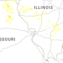
Missouri
| Local Time | Report Details |
|---|---|
| 5:15 PM CDT | Quarter sized hail reported near Allendale, MO, 84.3 miles SSW of Des Moines, IA |
| 8:20 PM CDT | Quarter sized hail reported near Moberly, MO, 32.7 miles N of Columbia, MO |
| 10:10 PM CDT | Quarter sized hail reported near Lentner, MO, 46 miles NNE of Columbia, MO, largest hail was one inch. most hail was much smaller. winds gusting up to 20 mph. |
| 11:29 PM CDT | Public weather station reported 59.9 mp in atchison county MO, 65 miles SSE of Omaha, NE |
| 12:22 AM CDT | Storm damage reported in buchanan county MO, 49.2 miles NNW of Kansas City, MO |
| 12:36 AM CDT | Storm damage reported in buchanan county MO, 49.2 miles NNW of Kansas City, MO |
| 3:21 AM CDT | Missouri mesone in monroe county MO, 53.9 miles S of Kahoka, MO |
| 3:40 AM CDT | Power line reported down on east liberty street and minor house damage due to downed trees in mexico in audrain county MO, 28.7 miles ENE of Columbia, MO |
| 3:40 AM CDT | 1900 without power in mexico... rural areas surrounding mexico without power as well. trees down across tow in audrain county MO, 28.2 miles ENE of Columbia, MO |
| 3:40 AM CDT | Tree blocking both lanes of k in audrain county MO, 41.8 miles ENE of Columbia, MO |
| 3:43 AM CDT | Tree down on house in center. tree down on highway hh north of new london and multiple reports of power out in hanniba in ralls county MO, 57.8 miles NE of Columbia, MO |
| 3:45 AM CDT | Mature tree with foliage uprooted and fell into house. no considerable structural damage reporte in marion county MO, 52.9 miles SSE of Kahoka, MO |
| 4:05 AM CDT | Via facebook: large tree took down power line... more tree damage reporte in pike county MO, 59.7 miles ENE of Columbia, MO |
| 4:30 AM CDT | Via twitter with picture included: thin tree snapped and damaged fenc in lincoln county MO, 49 miles WNW of Saint Louis, MO |
| 4:42 AM CDT | Via facebook with picture included: large tree fell onto hous in st. charles county MO, 24.4 miles WNW of Saint Louis, MO |
| 4:53 AM CDT | At kset... st. charles smartt fiel in st. charles county MO, 24.3 miles NNW of Saint Louis, MO |
| 4:57 AM CDT | At kstl... st. louis lambert international airpor in st. louis county MO, 12.1 miles NW of Saint Louis, MO |
| 5:00 AM CDT | Multiple tree branches down... some up to 6 inches in diamete in st. louis county MO, 9.1 miles WNW of Saint Louis, MO |
| 5:03 AM CDT | Tree limb estimated to be about 8 inches in diameter fallen from tre in st. louis county MO, 10 miles WNW of Saint Louis, MO |
| 5:07 AM CDT | Tree limbs dow in franklin county MO, 42.5 miles W of Saint Louis, MO |
| 5:10 AM CDT | Large tree down in south st. louis city near grand and eichelberger. time estimated from rada in st. louis city county MO, 4.8 miles SW of Saint Louis, MO |
Mississippi
| Local Time | Report Details |
|---|---|
| 5:20 PM CDT | Tree downed between tomnolen and stewar in webster county MS, 33.3 miles W of Starkville, MS |
| 5:48 PM CDT | Tree downed on a power line on pine knoll d in madison county MS, 8.4 miles NE of Jackson, MS |
| 5:56 PM CDT | Top of a tree snapped in the dinsmor neighborhoo in madison county MS, 9.1 miles N of Jackson, MS |
| 6:39 PM CDT | Several trees downed in madison county... especially in between flora and lake caroline and in the ms hwy 22 area. some trees downed on power line in madison county MS, 17.5 miles N of Jackson, MS |
| 6:40 PM CDT | Microburst with estimated 60 mph wind gusts in the providence subdivision with winds carrying smaller limbs and vegetation in the ai in madison county MS, 15.4 miles N of Jackson, MS |
| 7:05 PM CDT | Trees downed on scotland r in yazoo county MS, 30.5 miles N of Jackson, MS |
| 8:19 PM CDT | Power lines downed off ms hwy 1 in simpson county MS, 28.2 miles SE of Jackson, MS |
Vermont
| Local Time | Report Details |
|---|---|
| 7:00 PM EDT | Quarter sized hail reported near Highgate Center, VT, 33.2 miles NNE of Burlington, VT, cars dented. |
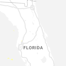
Florida
| Local Time | Report Details |
|---|---|
| 6:36 PM CDT | Tree down on a powerline on magnolia church roa in calhoun county FL, 50.7 miles W of Tallahassee, FL |
| 7:48 PM EDT | Trees and powerlines down on 3rd street south of bristo in liberty county FL, 41.8 miles W of Tallahassee, FL |
| 7:25 PM CDT | Powerlines down on unattended vehicle. report via jackson county fire scanne in jackson county FL, 65.4 miles ENE of Miramar Beach, FL |
Alabama
| Local Time | Report Details |
|---|---|
| 7:03 PM CDT | Power pole snapped on cr 112 at old town roa in dale county AL, 83.6 miles NE of Miramar Beach, FL |
| 12:12 AM CDT | Trees down on hwy 9 north of hwy 2 in coosa county AL, 40.1 miles WNW of Auburn, AL |
| 12:27 AM CDT | Ping Pong Ball sized hail reported near Rockford, AL, 47.2 miles WNW of Auburn, AL, reports of large hail around rockford. |
| 12:53 AM CDT | Quarter sized hail reported near Heflin, AL, 65.7 miles N of Auburn, AL, hail fell for over 15 minutes. |
| 1:29 AM CDT | Quarter sized hail reported near Anniston, AL, 59.4 miles E of Birmingham, AL, report from mping: quarter (1.00 in.). |
Texas
| Local Time | Report Details |
|---|---|
| 6:45 PM MDT | Tree branches down near vinton rd and doniphan d in el paso county TX, 15.6 miles NNW of El Paso, TX |
Kansas
| Local Time | Report Details |
|---|---|
| 8:07 PM CDT | Quarter sized hail reported near Grinnell, KS, 28.3 miles ESE of Colby, KS, pea-quarter sized hail via social media message. |
Nebraska
| Local Time | Report Details |
|---|---|
| 9:08 PM CDT | Golf Ball sized hail reported near Lincoln, NE, 53.8 miles WSW of Omaha, NE |
| 9:08 PM CDT | Half Dollar sized hail reported near Lincoln, NE, 50.8 miles WSW of Omaha, NE |
| 9:08 PM CDT | Quarter sized hail reported near Lincoln, NE, 52.7 miles WSW of Omaha, NE, report from mping:. |
| 9:09 PM CDT | Golf Ball sized hail reported near Lincoln, NE, 51.4 miles WSW of Omaha, NE, at the airport. |
| 9:10 PM CDT | Golf Ball sized hail reported near Seward, NE, 64.5 miles WSW of Omaha, NE, photo from social media. |
| 9:18 PM CDT | Half Dollar sized hail reported near Lincoln, NE, 48.8 miles WSW of Omaha, NE, report from mping. |
| 9:20 PM CDT | Half Dollar sized hail reported near Lincoln, NE, 50 miles SW of Omaha, NE |
| 9:21 PM CDT | Quarter sized hail reported near Lincoln, NE, 52.7 miles WSW of Omaha, NE, report from mping. same location but continued hail. |
| 9:32 PM CDT | Ping Pong Ball sized hail reported near Lincoln, NE, 50.6 miles SW of Omaha, NE |
| 9:33 PM CDT | Quarter sized hail reported near Lincoln, NE, 53.7 miles SW of Omaha, NE, report from mping. |
| 9:34 PM CDT | Ping Pong Ball sized hail reported near Lincoln, NE, 50.1 miles SW of Omaha, NE, report from mping. |
| 9:35 PM CDT | Quarter sized hail reported near Lincoln, NE, 50.3 miles SW of Omaha, NE |
| 9:35 PM CDT | Quarter sized hail reported near Lincoln, NE, 49.6 miles SW of Omaha, NE, report from mping. |
| 9:40 PM CDT | Golf Ball sized hail reported near Seward, NE, 65 miles E of Grand Island, NE |
| 11:09 PM CDT | 50 to 60 mph wind gust estimated by deputy in aubur in nemaha county NE, 61 miles S of Omaha, NE |
| 1:28 AM CDT | Quarter sized hail reported near Lincoln, NE, 47.5 miles SW of Omaha, NE |
| 1:30 AM CDT | Golf Ball sized hail reported near Malcolm, NE, 54.2 miles WSW of Omaha, NE, ping pong to golf ball sized hail. relayed via social media. |
| 1:33 AM CDT | Golf Ball sized hail reported near Malcolm, NE, 54.2 miles WSW of Omaha, NE, report from mping: golf ball (1.75 in.). |
| 1:44 AM CDT | Golf Ball sized hail reported near Lincoln, NE, 49.7 miles WSW of Omaha, NE, picture on social media. time estimated from radar. |
| 1:47 AM CDT | Half Dollar sized hail reported near Lincoln, NE, 48.8 miles WSW of Omaha, NE, report from mping: half dollar (1.25 in.). |
| 1:50 AM CDT | Golf Ball sized hail reported near Lincoln, NE, 47.5 miles SW of Omaha, NE, picture on social media. time estimated from radar. |
| 1:52 AM CDT | Hen Egg sized hail reported near Lincoln, NE, 47.1 miles WSW of Omaha, NE, picture on social media. time estimated from radar. |
| 1:53 AM CDT | Quarter sized hail reported near Lincoln, NE, 47.5 miles SW of Omaha, NE, report from mping: quarter (1.00 in.). |
| 1:53 AM CDT | Hen Egg sized hail reported near Lincoln, NE, 49.7 miles WSW of Omaha, NE, report from mping: hen egg (2.00 in.). |
| 1:57 AM CDT | Quarter sized hail reported near Lincoln, NE, 47.1 miles SW of Omaha, NE, relayed via broadcast media. |
| 5:08 AM CDT | Ping Pong Ball sized hail reported near Auburn, NE, 62.3 miles S of Omaha, NE |
Colorado
| Local Time | Report Details |
|---|---|
| 8:34 PM MDT | Half Dollar sized hail reported near Fort Lupton, CO, 28.7 miles NNE of Denver, CO |
| 8:48 PM MDT | Quarter sized hail reported near Fort Lupton, CO, 28.3 miles NNE of Denver, CO |
| 9:13 PM MDT | Ping Pong Ball sized hail reported near Brighton, CO, 24.1 miles NE of Denver, CO |
New Mexico
| Local Time | Report Details |
|---|---|
| 11:35 PM MDT | Awos station kskx taos muni airport. downburst winds from shower activit in taos county NM, 6 miles WNW of Taos, NM |
Illinois
| Local Time | Report Details |
|---|---|
| 3:35 AM CDT | Downed tree fell onto trailer... causing structural damage. time estimated by rada in schuyler county IL, 64.7 miles ESE of Kahoka, MO |
| 3:45 AM CDT | Several large trees down on il route 100. time estimated by rada in schuyler county IL, 55.8 miles SW of Peoria, IL |
| 3:47 AM CDT | Quarter sized hail reported near Rushville, IL, 64.7 miles ESE of Kahoka, MO |
| 4:00 AM CDT | Report from mping: 1-inch tree limbs broken and/or shingles blown off. time adjusted based on rada in mason county IL, 42.5 miles SW of Peoria, IL |
| 4:00 AM CDT | Report from mping: 1-inch tree limbs broken and/or shingles blown off. time estimated by rada in sangamon county IL, 58.5 miles S of Peoria, IL |
| 4:10 AM CDT | Numerous trees down across the southern half of sangamon county... mainly south of i-72. location approximate... time estimated by rada in sangamon county IL, 69.3 miles WNW of Mattoon, IL |
| 4:35 AM CDT | Tree damage in winchester. report relayed by broadcast media. time estimated by rada in scott county IL, 70.4 miles N of Saint Louis, MO |
| 4:35 AM CDT | Numerous trees down all over scott county. a stationary semi truck was blown over by the winds. time estimated by rada in scott county IL, 73.9 miles N of Saint Louis, MO |
| 9:49 AM UTC | Via facebook with pictures: 4x4 corner post down... limbs down... and mailboxes blown off their post in macoupin county IL, 31.5 miles NNE of Saint Louis, MO |
| 4:55 AM CDT | Via facebook: part of a tree down... no power.. in greene county IL, 52 miles N of Saint Louis, MO |
| 5:00 AM CDT | Widespread tree damage with numerous large trees down. report relayed by broadcast media and time estimated by rada in shelby county IL, 37.5 miles WSW of Mattoon, IL |
| 5:10 AM CDT | At k3lf... litchfield airpor in montgomery county IL, 47.1 miles NE of Saint Louis, MO |
| 5:10 AM CDT | At kaln... st. louis regional airpor in madison county IL, 19.8 miles NNE of Saint Louis, MO |
| 5:11 AM CDT | Trees and powerlines down in litchfield... i in montgomery county IL, 47.9 miles NE of Saint Louis, MO |
| 5:12 AM CDT | Via twitter with picture: siding peeling off side of building in tow in madison county IL, 16.9 miles NNE of Saint Louis, MO |
| 5:12 AM CDT | 12 inch tree uprooted and damaged fenc in madison county IL, 17.7 miles NNE of Saint Louis, MO |
| 5:15 AM CDT | At kcps... st. louis downtown airpor in st. clair county IL, 4.5 miles SSE of Saint Louis, MO |
| 5:30 AM CDT | Trees down in tow in montgomery county IL, 50 miles WSW of Mattoon, IL |
| 5:41 AM CDT | Via twitter with pictures included: tree damage and limbs down. tweet estimated wind gusts of 70 mp in montgomery county IL, 53.8 miles NE of Saint Louis, MO |
| 5:51 AM CDT | Extensive tree damage reported along the shelby/fayette county line in herric in fayette county IL, 37.4 miles WSW of Mattoon, IL |
| 6:07 AM CDT | Via twitter with picture: small tree snapped and estimated wind speeds of 50 to 60 mp in marion county IL, 58.3 miles E of Saint Louis, MO |
| 6:09 AM CDT | Shed completely destroyed and scattered across roa in washington county IL, 57.8 miles ESE of Saint Louis, MO |
| 6:34 AM CDT | Trees and powerlines down in coffeen... i in montgomery county IL, 54.1 miles NE of Saint Louis, MO |
| 11:40 AM UTC | Trees and power lines dow in jefferson county IL, 73.1 miles ESE of Saint Louis, MO |
Wyoming
| Local Time | Report Details |
|---|---|
| 2:40 AM MDT | Storm damage reported in banner county NE, 29.4 miles SW of Scottsbluff, NE |
Connect with Interactive Hail Maps