

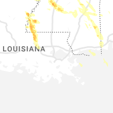
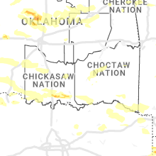
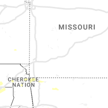
Hail Map for Saturday, June 17, 2023

Number of Impacted Households on 6/17/2023
0
Impacted by 1" or Larger Hail
0
Impacted by 1.75" or Larger Hail
0
Impacted by 2.5" or Larger Hail
Square Miles of Populated Area Impacted on 6/17/2023
0
Impacted by 1" or Larger Hail
0
Impacted by 1.75" or Larger Hail
0
Impacted by 2.5" or Larger Hail


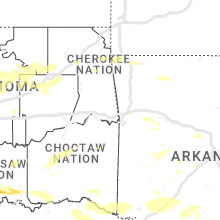


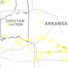


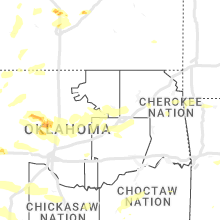


Cities Most Affected by Hail Storms of 6/17/2023
| Hail Size | Demographics of Zip Codes Affected | ||||||
|---|---|---|---|---|---|---|---|
| City | Count | Average | Largest | Pop Density | House Value | Income | Age |
| Shreveport, LA | 5 | 2.35 | 3.00 | 236 | $73k | $30.7k | 34.8 |
| Beaver, OK | 3 | 2.92 | 3.00 | 2 | $58k | $38.0k | 41.8 |
| Brewton, AL | 3 | 2.75 | 2.75 | 33 | $68k | $30.1k | 40.4 |
| Turpin, OK | 3 | 2.42 | 2.75 | 6 | $83k | $37.5k | 37.2 |
| Leakesville, MS | 3 | 2.17 | 2.75 | 12 | $62k | $28.0k | 36.2 |
| Sublette, KS | 2 | 2.50 | 3.00 | 2 | $88k | $39.7k | 34.5 |
| Copeland, KS | 2 | 2.38 | 3.00 | 2 | $66k | $39.8k | 31.9 |
| Merkel, TX | 2 | 2.38 | 3.00 | 15 | $42k | $32.0k | 40.5 |
| Reydon, OK | 2 | 2.25 | 2.25 | 3 | $31k | $29.8k | 40.0 |
| Laverne, OK | 2 | 1.88 | 2.00 | 1 | $40k | $34.0k | 40.0 |
| Goldthwaite, TX | 1 | 3.50 | 3.50 | 6 | $53k | $30.4k | 45.6 |
| Mullin, TX | 1 | 2.75 | 2.75 | 3 | $38k | $30.4k | 45.6 |
| Liberal, KS | 1 | 2.75 | 2.75 | 66 | $73k | $36.6k | 28.8 |
| Utica, MS | 1 | 1.75 | 1.75 | 18 | $55k | $32.3k | 40.0 |
| Coleman, TX | 1 | 1.75 | 1.75 | 15 | $34k | $25.8k | 45.4 |
| Iowa Park, TX | 1 | 1.75 | 1.75 | 48 | $60k | $42.2k | 39.7 |
| Lucedale, MS | 1 | 1.75 | 1.75 | 51 | $68k | $34.7k | 36.3 |
| Cimarron, KS | 1 | 1.75 | 1.75 | 2 | $80k | $40.2k | 34.1 |
| Mobeetie, TX | 1 | 1.75 | 1.75 | 2 | $33k | $33.8k | 44.5 |
| Miami, TX | 1 | 1.75 | 1.75 | 1 | $48k | $38.1k | 40.5 |
| Waynesboro, MS | 1 | 1.75 | 1.75 | 31 | $57k | $26.2k | 37.1 |
| Des Moines, NM | 1 | 1.75 | 1.75 | 0 | $39k | $26.4k | 48.0 |
| Saint Francisville, LA | 1 | 1.75 | 1.75 | 19 | $103k | $37.7k | 42.2 |
| Moss Point, MS | 1 | 1.75 | 1.75 | 92 | $71k | $38.6k | 39.2 |
| Anson, TX | 1 | 1.75 | 1.75 | 17 | $31k | $26.5k | 39.9 |
| Cameron, MO | 1 | 1.75 | 1.75 | 60 | $81k | $34.6k | 38.2 |
| Snyder, TX | 1 | 1.75 | 1.75 | 15 | $43k | $31.7k | 36.2 |
| Pattonsburg, MO | 1 | 1.75 | 1.75 | 7 | $57k | $31.5k | 41.7 |
Hail and Wind Damage Spotted on 6/17/2023
Filter by Report Type:Hail ReportsWind Reports
States Impacted
Florida, Oklahoma, Mississippi, Alabama, New Mexico, New Jersey, Colorado, Louisiana, Missouri, Texas, Kansas, Iowa, Arkansas, TennesseeFlorida
| Local Time | Report Details |
|---|---|
| 10:49 AM EDT | Asos at orlando international airport measured a wind gust of 57kt/66mp in orange county FL, 8.9 miles SSE of Orlando, FL |
| 11:55 AM EDT | (delayed report) peak gust 59 mph at kennedy space center (jscnasa) tower 509 (elevation 54 feet in brevard county FL, 43 miles E of Orlando, FL |
| 12:19 PM EDT | Weatherflow station indian river db27 (xind) measured a wind gust of 50kt/58mph from the northwes in amz552 county FL, 48.3 miles NNW of Port Saint Lucie, FL |
| 3:30 PM CDT | Quarter sized hail reported near Altha, FL, 51.5 miles W of Tallahassee, FL, pictures of hail around quarter size in altha. |
| 4:29 PM CDT | Fort walton beach weatherflow station recorded a sustained wind of 42 kts with a max gust of 57 kt in gmz635 county FL, 12 miles W of Miramar Beach, FL |
| 5:40 PM EDT | Law enforcement reported tree down on the roa in gadsden county FL, 18.9 miles NW of Tallahassee, FL |
| 6:15 PM EDT | Public reported six trees knocked dow in leon county FL, 11 miles E of Tallahassee, FL |
| 6:20 PM EDT | Trees down across the intersection of old st. augustine road and miners road in leon county florid in leon county FL, 9.7 miles E of Tallahassee, FL |
| 6:22 PM EDT | Public reported trees down on i-10 around exit 21 in jefferson county FL, 14.6 miles E of Tallahassee, FL |
| 6:25 PM EDT | Tree down at the intersection of baum road and wadesboro rd. in leon county florid in leon county FL, 11.9 miles ENE of Tallahassee, FL |
| 6:25 PM EDT | Jefferson dispatch reported numerous trees down power is out through out the count in jefferson county FL, 19.8 miles E of Tallahassee, FL |
| 6:25 PM EDT | Tree down at the intersection of baum road and mahan driv in leon county FL, 12.9 miles ENE of Tallahassee, FL |
| 6:25 PM EDT | Corrects previous tstm wnd dmg report from 3 s concord. tree down at the intersection of veterans memorial drive and mahan drive in leon county florid in leon county FL, 14.8 miles ENE of Tallahassee, FL |
| 6:25 PM EDT | Corrects previous tstm wnd dmg report from 3 se concord. tree down at 15978 mahan dr. in leon county florid in leon county FL, 17.3 miles ENE of Tallahassee, FL |
| 6:30 PM EDT | Tree down at the intersection of miccosukee rd and wiley rd in leon county florid in leon county FL, 15.4 miles NE of Tallahassee, FL |
| 6:30 PM EDT | Corrects previous tstm wnd dmg report from 2 w concord. multiple trees down on miccosukee rd. causing several cars to be trapped on the roadwa in leon county FL, 14.6 miles NE of Tallahassee, FL |
| 6:40 PM EDT | Tree down at the intersection of veterans memorial drive and mahan drive in leon county florid in leon county FL, 14.8 miles ENE of Tallahassee, FL |
| 6:40 PM EDT | Tree down at 15978 mahan dr. in leon county florid in leon county FL, 17.3 miles ENE of Tallahassee, FL |
| 6:45 PM EDT | 1 tree down on highway 19 in madison county florid in madison county FL, 31.4 miles ESE of Tallahassee, FL |
| 6:54 PM EDT | Multiple trees down on miccosukee rd. causing several cars to be trapped on the roadwa in leon county FL, 14.6 miles NE of Tallahassee, FL |
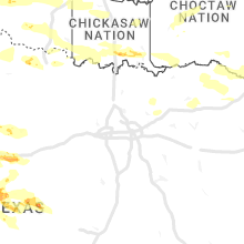
Oklahoma
| Local Time | Report Details |
|---|---|
| 10:22 AM CDT | Hen Egg sized hail reported near Reydon, OK, 68.4 miles SSW of Woodward, OK, facebook report. |
| 5:15 PM CDT | Storm damage reported in cimarron county OK, 123.3 miles NNE of Tucumcari, NM |
| 5:37 PM CDT | Tennis Ball sized hail reported near Turpin, OK, 77.2 miles S of Garden City, KS, picture submitted via social media. time estimated on radar. |
| 5:37 PM CDT | Quarter sized hail reported near Hooker, OK, 84.6 miles S of Garden City, KS, quarter sized hail reported by storm chaser via social media 2 miles east of adams. |
| 5:54 PM CDT | Hen Egg sized hail reported near Turpin, OK, 81.4 miles S of Garden City, KS, hail reported via spotter network. |
| 5:57 PM CDT | Baseball sized hail reported near Turpin, OK, 81.3 miles S of Garden City, KS, hail report submitted via spotter network. |
| 6:01 PM CDT | Tea Cup sized hail reported near Beaver, OK, 75 miles WNW of Woodward, OK, photo submitted via social media. time estimated on radar. |
| 6:03 PM CDT | Quarter sized hail reported near Beaver, OK, 74.8 miles WNW of Woodward, OK, report submitted via spotter network. |
| 6:20 PM CDT | Baseball sized hail reported near Beaver, OK, 74 miles WNW of Woodward, OK, report submitted via spotter network. |
| 6:22 PM CDT | Tea Cup sized hail reported near Beaver, OK, 74 miles WNW of Woodward, OK, report submitted via spotter network. |
| 6:25 PM CDT | Storm damage reported in texas county OK, 87.9 miles SW of Garden City, KS |
| 6:50 PM CDT | Storm damage reported in texas county OK, 79 miles SSW of Garden City, KS |
| 6:53 PM CDT | Storm damage reported in texas county OK, 95.6 miles SSW of Garden City, KS |
| 7:05 PM CDT | Storm damage reported in beaver county OK, 67.8 miles WNW of Woodward, OK |
| 7:32 PM CDT | Golf Ball sized hail reported near Laverne, OK, 45.4 miles WNW of Woodward, OK, report submitted via spotter network. |
| 7:35 PM CDT | Storm damage reported in beaver county OK, 49.3 miles WNW of Woodward, OK |
| 7:43 PM CDT | Hen Egg sized hail reported near Laverne, OK, 42.1 miles WNW of Woodward, OK, report from mping: hen egg (2.00 in.). |
| 7:44 PM CDT | Report from mping: 3-inch tree limbs broken; power poles broken. photo confirmed via twitte in beaver county OK, 42.1 miles WNW of Woodward, OK |
| 8:02 PM CDT | Report from mping: 3-inch tree limbs broken; power poles broke in beaver county OK, 41.2 miles WNW of Woodward, OK |
| 8:06 PM CDT | Em reports power line damage in region of the arnett vicinity. time estimated by rada in ellis county OK, 29 miles SW of Woodward, OK |
| 8:15 PM CDT | Mesonet station buff buffal in harper county OK, 30.4 miles NNW of Woodward, OK |
| 8:16 PM CDT | Em reports power line damage in vicinity of fort supply. time estimated by rada in woodward county OK, 13.4 miles NW of Woodward, OK |
| 8:25 PM CDT | Mesonet station wood woodwar in woodward county OK, 1.5 miles SW of Woodward, OK |
| 8:50 PM CDT | Mesonet station free freedo in woodward county OK, 25 miles NE of Woodward, OK |
| 8:50 PM CDT | Social media video - damage to tree limbs. time estimate in woodward county OK, 11.1 miles SSE of Woodward, OK |
| 9:00 PM CDT | Mesonet station seil seilin in woodward county OK, 26.1 miles SE of Woodward, OK |
| 9:10 PM CDT | Mesonet station dw7732 alv in woods county OK, 37.5 miles NE of Woodward, OK |
| 9:26 PM CDT | Storm damage reported in major county OK, 53.5 miles E of Woodward, OK |
| 9:35 PM CDT | Mesonet station cher cheroke in alfalfa county OK, 61.8 miles ENE of Woodward, OK |
| 9:50 PM CDT | Mesonet station ring ringlin in jefferson county OK, 55.8 miles ENE of Wichita Falls, TX |
| 9:55 PM CDT | Mesonet station laho lahom in major county OK, 70.8 miles NNW of Oklahoma City, OK |
| 10:10 PM CDT | Ardmore mesone in carter county OK, 54.9 miles WSW of Atoka, OK |
| 10:15 PM CDT | Awos station kjwg watong in blaine county OK, 57.6 miles WNW of Oklahoma City, OK |
| 10:18 PM CDT | Awos station kend enid vance af in garfield county OK, 62.6 miles NNW of Oklahoma City, OK |
| 10:20 PM CDT | Tree down on state hwy 1 and cr 3510. radar estimated tim in pontotoc county OK, 41.7 miles WNW of Atoka, OK |
| 10:22 PM CDT | Hen Egg sized hail reported near Reydon, OK, 68.4 miles SSW of Woodward, OK, corrects previous hail report from 6 wnw dempsey. facebook report. |
| 10:30 PM CDT | Mesonet station madi madil in marshall county OK, 52.3 miles WSW of Atoka, OK |
| 10:34 PM CDT | Roof damaged. near highway 1 and buffalo rd. radar estimated tim in johnston county OK, 38.1 miles WSW of Atoka, OK |
| 10:35 PM CDT | Mesonet station brec breckinridg in garfield county OK, 65.4 miles N of Oklahoma City, OK |
| 10:55 PM CDT | Storm damage reported in canadian county OK, 13.9 miles NW of Oklahoma City, OK |
| 10:55 PM CDT | Storm damage reported in logan county OK, 44.2 miles N of Oklahoma City, OK |
| 10:56 PM CDT | Storm damage reported in oklahoma county OK, 8.3 miles WNW of Oklahoma City, OK |
| 10:59 PM CDT | Storm damage reported in logan county OK, 26.6 miles N of Oklahoma City, OK |
| 10:59 PM CDT | Storm damage reported in logan county OK, 26.7 miles NNE of Oklahoma City, OK |
| 11:05 PM CDT | Storm damage reported in payne county OK, 43.5 miles NNE of Oklahoma City, OK |
| 11:08 PM CDT | Storm damage reported in oklahoma county OK, 5.8 miles SW of Oklahoma City, OK |
| 11:10 PM CDT | Storm damage reported in oklahoma county OK, 3.4 miles E of Oklahoma City, OK |
| 11:11 PM CDT | 4 in. diameter tree limbs broken... gutters and shingles damaged near 23rd and pen in oklahoma county OK, 2.6 miles NW of Oklahoma City, OK |
| 11:14 PM CDT | Large tree down at parsons and floo in cleveland county OK, 18.5 miles SSE of Oklahoma City, OK |
| 11:15 PM CDT | Storm damage reported in cleveland county OK, 15.5 miles S of Oklahoma City, OK |
| 11:15 PM CDT | Storm damage reported in bryan county OK, 33.2 miles SSW of Atoka, OK |
| 11:15 PM CDT | Storm damage reported in payne county OK, 45.6 miles NE of Oklahoma City, OK |
| 11:15 PM CDT | Storm damage reported in cleveland county OK, 16.2 miles S of Oklahoma City, OK |
| 11:17 PM CDT | 8-10 inch diameter tree limb dow in cleveland county OK, 20 miles SSE of Oklahoma City, OK |
| 11:20 PM CDT | Storm damage reported in payne county OK, 45.6 miles NE of Oklahoma City, OK |
| 11:21 PM CDT | Storm damage reported in payne county OK, 52.4 miles NNE of Oklahoma City, OK |
| 11:23 PM CDT | Several homes with roof damage in indianola and crowde in pittsburg county OK, 57.1 miles NNE of Atoka, OK |
| 11:25 PM CDT | Storm damage reported in oklahoma county OK, 8.2 miles ESE of Oklahoma City, OK |
| 11:26 PM CDT | Storm damage reported in payne county OK, 44.3 miles WSW of Tulsa, OK |
| 11:26 PM CDT | Tree limbs down... car port tossed... power line dow in payne county OK, 44.1 miles WSW of Tulsa, OK |
| 11:55 PM CDT | Large tree uprooted and down across roa in creek county OK, 24 miles W of Tulsa, OK |
| 11:55 PM CDT | Street signs blown over... large trees uproote in creek county OK, 22.3 miles W of Tulsa, OK |
| 11:57 PM CDT | Storm damage reported in choctaw county OK, 43.8 miles SE of Atoka, OK |
| 12:05 AM CDT | Storm damage reported in creek county OK, 17.2 miles W of Tulsa, OK |
| 12:05 AM CDT | Roof damage to a home; several 15-24 inch diameter trees down; power lines down. time estimated from rada in tulsa county OK, 6.6 miles W of Tulsa, OK |
| 12:05 AM CDT | Large tree dow in creek county OK, 9.4 miles SW of Tulsa, OK |
| 12:05 AM CDT | Power lines down at 209th w ave and wekiwa r in tulsa county OK, 12.7 miles W of Tulsa, OK |
| 12:06 AM CDT | Several large tree limbs (3-4 inch) down in neighborhood; time estimated by rada in creek county OK, 11.2 miles SSW of Tulsa, OK |
| 12:09 AM CDT | Storm damage reported in creek county OK, 33.2 miles W of Tulsa, OK |
| 12:13 AM CDT | Jenks riverside airpor in tulsa county OK, 4.3 miles ESE of Tulsa, OK |
| 12:15 AM CDT | Numerous 1-3 inch limbs dow in tulsa county OK, 9 miles SE of Tulsa, OK |
| 12:15 AM CDT | Tree down. report relayed from publi in le flore county OK, 20.4 miles SW of Fort Smith, AR |
| 12:20 AM CDT | Trees and power lines down near 41st and yal in tulsa county OK, 4.3 miles ESE of Tulsa, OK |
| 12:21 AM CDT | Trees down on old 98 from valliant to wright city. trees also down on state highway 98 north of hwy 7 in mccurtain county OK, 67.1 miles ESE of Atoka, OK |
| 12:27 AM CDT | Reported near 31st and peori in tulsa county OK, 4.3 miles ESE of Tulsa, OK |
| 12:30 AM CDT | Corrects time of previous tstm wnd gst report from tulsa. tulsa international airpor in tulsa county OK, 4.3 miles ESE of Tulsa, OK |
| 12:30 AM CDT | Several tree limbs down. winds estimated 70 mp in tulsa county OK, 16 miles NNE of Tulsa, OK |
| 12:35 AM CDT | Storm damage reported in sequoyah county OK, 21.4 miles WNW of Fort Smith, AR |
| 12:38 AM CDT | Large section of tree canopies/large branches snapped off near 106th st n and n 197th; time estimated by rada in rogers county OK, 17.5 miles NE of Tulsa, OK |
| 12:45 AM CDT | Numerous tree limbs and power lines down from checotah to eufaul in mcintosh county OK, 52.8 miles SSE of Tulsa, OK |
| 12:45 AM CDT | A 61 mph wind gust was recorded at oklahoma mesonet idabel sit in mccurtain county OK, 59.9 miles W of Nashville, AR |
| 12:50 AM CDT | Tulsa international airpor in tulsa county OK, 4.3 miles ESE of Tulsa, OK |
| 12:50 AM CDT | Storm damage reported in rogers county OK, 27 miles E of Tulsa, OK |
| 12:58 AM CDT | Sveral large trees down; structural damage to a brick building. time estimated from rada in mayes county OK, 46.2 miles E of Tulsa, OK |
| 1:00 AM CDT | Storm damage reported in cherokee county OK, 50.2 miles E of Tulsa, OK |
| 1:00 AM CDT | Numerous large tree limbs down; time estimated by rada in rogers county OK, 15 miles ENE of Tulsa, OK |
| 1:00 AM CDT | Roof blown off of commercial building; numerous large tree limbs dow in ottawa county OK, 64.3 miles SSE of Chanute, KS |
| 1:05 AM CDT | Storm damage reported in cherokee county OK, 50.1 miles ESE of Tulsa, OK |
| 1:05 AM CDT | Storm damage reported in mayes county OK, 39.2 miles ENE of Tulsa, OK |
| 1:20 AM CDT | Storm damage reported in cherokee county OK, 43.1 miles NW of Fort Smith, AR |
| 1:21 AM CDT | Storm damage reported in mayes county OK, 36.6 miles E of Tulsa, OK |
| 1:35 AM CDT | Several trees dow in mcintosh county OK, 53.9 miles SSE of Tulsa, OK |
| 1:55 AM CDT | Storm damage reported in delaware county OK, 74.7 miles ENE of Tulsa, OK |
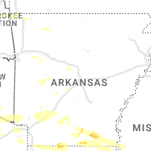
Mississippi
| Local Time | Report Details |
|---|---|
| 1:55 PM CDT | Golf Ball sized hail reported near Waynesboro, MS, 77 miles NNW of Mobile, AL |
| 2:10 PM CDT | Report of tree downed on intersection of airport rd and old johnson r in adams county MS, 80.8 miles SW of Jackson, MS |
| 2:18 PM CDT | Quarter sized hail reported near Richton, MS, 65.1 miles NW of Mobile, AL, report from mping: quarter (1.00 in.). |
| 2:45 PM CDT | Baseball sized hail reported near Leakesville, MS, 50.6 miles NW of Mobile, AL |
| 2:46 PM CDT | Hen Egg sized hail reported near Leakesville, MS, 48.1 miles NW of Mobile, AL |
| 2:49 PM CDT | Quarter sized hail reported near Natchez, MS, 88.8 miles NNE of Lafayette, LA, marble sized hail reported. |
| 2:58 PM CDT | Golf Ball sized hail reported near Leakesville, MS, 48.2 miles NW of Mobile, AL |
| 2:58 PM CDT | Half Dollar sized hail reported near Leakesville, MS, 43.9 miles NW of Mobile, AL, social media picture of hail dollar sized hail in leakesville... ms. time using radar. |
| 3:16 PM CDT | Report of multiple trees and powerlines downe in jones county MS, 78.5 miles SE of Jackson, MS |
| 3:28 PM CDT | Ping Pong Ball sized hail reported near Lucedale, MS, 35.7 miles WNW of Mobile, AL, social media photo of hail ranging from quarter to ping pong ball size. time using radar. |
| 3:50 PM CDT | Quarter sized hail reported near Woodville, MS, 74.5 miles NE of Lafayette, LA |
| 4:05 PM CDT | Ping Pong Ball sized hail reported near Moss Point, MS, 26.1 miles W of Mobile, AL |
| 4:15 PM CDT | Golf Ball sized hail reported near Moss Point, MS, 26.9 miles WSW of Mobile, AL |
| 4:58 PM CDT | Golf Ball sized hail reported near Lucedale, MS, 29 miles WNW of Mobile, AL, social media picture of hail ranging from quarter size to golf ball size. time using radar. |
| 5:15 AM CDT | Trees and power lines down on west commerce st just east of hwy 51 in hernand in desoto county MS, 23 miles S of Memphis, TN |
| 5:57 AM CDT | Quarter sized hail reported near Utica, MS, 27.2 miles WSW of Jackson, MS, nickel to quarter size hail reported on erine martin rd and morrison rd. |
| 6:00 AM CDT | Golf Ball sized hail reported near Utica, MS, 29.4 miles WSW of Jackson, MS, quarter size hail reported in downtown utica and golf ball size hail on morrison rd. |
Alabama
| Local Time | Report Details |
|---|---|
| 2:13 PM CDT | Social media report of trees blocking county rd 6 west of castleberry... al. time using rada in conecuh county AL, 49.3 miles SSE of Camden, AL |
| 2:34 PM CDT | Baseball sized hail reported near Brewton, AL, 60.9 miles NNW of Miramar Beach, FL |
| 2:40 PM CDT | Quarter sized hail reported near Millry, AL, 68.3 miles WSW of Camden, AL |
| 2:40 PM CDT | Baseball sized hail reported near Brewton, AL, 60.7 miles NW of Miramar Beach, FL |
| 2:48 PM CDT | Baseball sized hail reported near Brewton, AL, 60.9 miles NNW of Miramar Beach, FL, social media photo of baseball size hail on us29 east of brewton. time using radar. |
| 3:57 PM CDT | Storm debris blocking al 217 in both directions. time using rada in mobile county AL, 11.7 miles NW of Mobile, AL |
| 4:14 PM CDT | Quarter sized hail reported near Mobile, AL, 18.4 miles WSW of Mobile, AL, video on social media of quarter hail falling on newman rd. time using radar. |
| 4:20 PM CDT | Quarter sized hail reported near Grand Bay, AL, 22.2 miles SW of Mobile, AL, social media report of quarter hail in grand bay... al. time using radar. |
New Mexico
| Local Time | Report Details |
|---|---|
| 1:53 PM MDT | Asos station krtn raton crews airpor in colfax county NM, 63.6 miles ENE of Taos, NM |
| 2:01 PM MDT | Asos station krtn raton crews airpor in colfax county NM, 63.6 miles ENE of Taos, NM |
| 2:30 PM MDT | Quarter sized hail reported near Des Moines, NM, 99.4 miles ENE of Taos, NM |
| 2:37 PM MDT | Quarter sized hail reported near Des Moines, NM, 99.4 miles ENE of Taos, NM |
| 2:55 PM MDT | Ping Pong Ball sized hail reported near Des Moines, NM, 99.9 miles ENE of Taos, NM |
| 3:22 PM MDT | Golf Ball sized hail reported near Des Moines, NM, 110 miles N of Tucumcari, NM |
New Jersey
| Local Time | Report Details |
|---|---|
| 4:25 PM EDT | Several reports of tree branches down across south brunswick including rt 1 and davidson mill road. time estimated from rada in middlesex county NJ, 35.3 miles SW of Brooklyn, NY |
Colorado
| Local Time | Report Details |
|---|---|
| 2:59 PM MDT | Storm damage reported in lincoln county CO, 53 miles ENE of Pueblo, CO |
| 4:46 PM MDT | Storm damage reported in baca county CO, 106.5 miles WSW of Garden City, KS |
Louisiana
| Local Time | Report Details |
|---|---|
| 4:07 PM CDT | Golf Ball sized hail reported near Saint Francisville, LA, 65.7 miles NE of Lafayette, LA, hail up to the size of golf balls reported in spillman. |
| 4:10 PM CDT | Ping Pong Ball sized hail reported near Saint Francisville, LA, 65.4 miles NE of Lafayette, LA, quarter to ping pong ball size hail around lake rosemound. |
| 4:15 PM CDT | Quarter sized hail reported near Jackson, LA, 65.2 miles NE of Lafayette, LA, corrects previous tstm wnd dmg report from 1 e jackson. quarter size hail. |
| 4:15 PM CDT | Multiple trees down around bains and blocking the highway in west feliciana county LA, 56.2 miles NE of Lafayette, LA |
| 4:15 PM CDT | Quarter size hai in east feliciana county LA, 65.2 miles NE of Lafayette, LA |
| 4:20 PM CDT | Quarter sized hail reported near Saint Francisville, LA, 55.2 miles NE of Lafayette, LA, quarter size hail reported at the oaks plantation. |
| 4:25 PM CDT | Corrects previous tstm wnd dmg report from 2 nnw st. francisville. multiple power poles down along hwy 6 in west feliciana county LA, 55.2 miles NE of Lafayette, LA |
| 4:25 PM CDT | Quarter sized hail reported near Saint Francisville, LA, 61.3 miles NE of Lafayette, LA, quarter size hail. |
| 4:25 PM CDT | Shingles blown off roofs of homes in the bluffs subdivisio in west feliciana county LA, 61.2 miles NE of Lafayette, LA |
| 4:25 PM CDT | Quarter sized hail reported near Saint Francisville, LA, 61.2 miles NE of Lafayette, LA, strong winds also removed some shingles from the roofs of homes in the bluffs subdivision. |
| 4:28 PM CDT | Quarter sized hail reported near Saint Francisville, LA, 54.6 miles NE of Lafayette, LA |
| 4:29 PM CDT | Large tree down on commerce st blocking the road by the courthous in west feliciana county LA, 54.6 miles NE of Lafayette, LA |
| 4:42 PM CDT | Quarter sized hail reported near Zachary, LA, 54.7 miles NE of Lafayette, LA, quarter size hail. |
| 4:50 PM CDT | Quarter sized hail reported near Slaughter, LA, 60.3 miles ENE of Lafayette, LA |
| 4:52 PM CDT | Multiple power poles down along hwy 6 in west feliciana county LA, 55.2 miles NE of Lafayette, LA |
| 4:55 PM CDT | Trees and power lines down in the city of bake in east baton rouge county LA, 57.5 miles ENE of Lafayette, LA |
| 5:02 PM CDT | Asos station kbtr baton rouge airpor in east baton rouge county LA, 56 miles ENE of Lafayette, LA |
| 5:04 PM CDT | Ping Pong Ball sized hail reported near Baton Rouge, LA, 53.6 miles ENE of Lafayette, LA, report from mping: ping pong ball (1.50 in.). |
| 5:11 PM CDT | Report from mping: 1-inch tree limbs broken; shingles blown of in livingston county LA, 63.2 miles NW of New Orleans, LA |
| 5:11 PM CDT | Fire department reports a tree on a house at clark drive and rafe mayer rd in unincorporated east baton rouge paris in east baton rouge county LA, 55 miles ENE of Lafayette, LA |
| 5:20 PM CDT | Public reports on social media a tree is down (snapped) in brusley... l in west baton rouge county LA, 47.5 miles ENE of Lafayette, LA |
| 5:22 PM CDT | Quarter sized hail reported near Baton Rouge, LA, 53.2 miles ENE of Lafayette, LA, report from mping: quarter (1.00 in.). |
| 5:23 PM CDT | Measured at top of tiger stadiu in east baton rouge county LA, 51.7 miles ENE of Lafayette, LA |
| 5:30 PM CDT | Minor structural damage. metal roofing from a patio or shed blown onto a house and shingles ripped of in ascension county LA, 57.2 miles WNW of New Orleans, LA |
| 6:15 PM CDT | Quarter sized hail reported near Shreveport, LA, 9.5 miles WNW of Shreveport, LA, estimated dime to quarter size hail reported by police. |
| 6:20 PM CDT | Quarter sized hail reported near Shreveport, LA, 6 miles NNW of Shreveport, LA, quarter size hail posted near the intersection of highway 1 and highway 71 in north shreveport. |
| 6:20 PM CDT | Tea Cup sized hail reported near Shreveport, LA, 9.3 miles NW of Shreveport, LA, photo via social media of 3 inch hail just off old mooringsport road in the blanchard area. |
| 6:20 PM CDT | Tea Cup sized hail reported near Shreveport, LA, 9.7 miles NW of Shreveport, LA, report of 3 inch hail just off old mooringsport road in the blanchard area. |
| 6:20 PM CDT | Quarter sized hail reported near Shreveport, LA, 5.5 miles NW of Shreveport, LA, quarter size hail posted near the intersection of highway 1 and highway 71. |
| 6:20 PM CDT | Hen Egg sized hail reported near Shreveport, LA, 9.3 miles NW of Shreveport, LA, hail near 2 inches reported along highway 1 in the blanchard area. |
| 6:20 PM CDT | Hen Egg sized hail reported near Shreveport, LA, 11.5 miles NW of Shreveport, LA, hail reported larger than golf ball via social media along highway 1 near blanchard. |
| 6:25 PM CDT | Golf Ball sized hail reported near Shreveport, LA, 9.5 miles WNW of Shreveport, LA, hail larger than ping pong size in the town of blanchard... with golf ball size hail reported at elsie truck stop along highway 1. |
| 6:40 PM CDT | Ping Pong Ball sized hail reported near Bossier City, LA, 7.3 miles N of Shreveport, LA, ping pong size hail reported between bossier city and benton in the willow heights subdivision. |
| 6:42 PM CDT | Ping Pong Ball sized hail reported near Bossier City, LA, 7.3 miles N of Shreveport, LA, ping pong size hail reported between bossier city and benton in the willow heights subdivision. |
| 6:45 PM CDT | Ping Pong Ball sized hail reported near Bossier City, LA, 7.6 miles NNE of Shreveport, LA, hail up to ping pong size reported in the legacy subdivision. |
| 6:45 PM CDT | Quarter sized hail reported near Benton, LA, 12.1 miles N of Shreveport, LA, quarter size hail on palmetto road in benton |
| 6:45 PM CDT | Half Dollar sized hail reported near Mooringsport, LA, 16.8 miles NW of Shreveport, LA, hail reported at mooringsport baptist church. |
| 6:50 PM CDT | Quarter sized hail reported near Benton, LA, 10.4 miles NNE of Shreveport, LA, hail reported in the woodlake south area near benton. |
| 6:55 PM CDT | Half Dollar sized hail reported near Mooringsport, LA, 17.3 miles NW of Shreveport, LA, social media photos of quarter to half dollar hail in mooringsport. |
| 7:35 PM CDT | Quarter sized hail reported near Cotton Valley, LA, 27.9 miles NE of Shreveport, LA, social media report of dime to quarter size hail in the cotton valley area. |
| 7:55 PM CDT | Trees down near intersection of highway 159 and highway 16 in webster county LA, 37.5 miles NE of Shreveport, LA |
| 8:05 PM CDT | Widespread trees and power lines down across the haynesvill in claiborne county LA, 47.3 miles NE of Shreveport, LA |
| 4:06 AM CDT | Trees and power lines down across hwy 17... gaddis street... and koerner stree in west carroll county LA, 31.2 miles ENE of Bastrop, LA |
Missouri
| Local Time | Report Details |
|---|---|
| 4:58 PM CDT | Golf Ball sized hail reported near Cameron, MO, 48.3 miles NNE of Kansas City, MO |
| 5:39 PM CDT | Quarter sized hail reported near Pattonsburg, MO, 72 miles NNE of Kansas City, MO |
| 5:45 PM CDT | Quarter sized hail reported near Polo, MO, 42.4 miles NE of Kansas City, MO, public report via social media. |
| 5:50 PM CDT | Golf Ball sized hail reported near Pattonsburg, MO, 69.7 miles NNE of Kansas City, MO, public measured 1.75 inch hail reported via social media. |
| 6:10 PM CDT | Quarter sized hail reported near Bethany, MO, 81 miles NNE of Kansas City, MO, at least quarter size hail estimated by public via social media. |
| 1:50 AM CDT | Several trees down in the noel and southwest city area. time estimated via rada in mcdonald county MO, 80 miles N of Fort Smith, AR |
| 2:00 AM CDT | Tree down into an electric transfomer in anderso in mcdonald county MO, 74.3 miles WSW of Springfield, MO |
| 2:08 AM CDT | Several trees down in the goodman are in mcdonald county MO, 69.3 miles WSW of Springfield, MO |
| 2:21 AM CDT | Delayed report. limbs down across roadway near seligma in barry county MO, 59.6 miles SW of Springfield, MO |
| 2:22 AM CDT | Storm damage reported in newton county MO, 64 miles WSW of Springfield, MO |
| 2:30 AM CDT | Several large branches reported down due to high wind in newton county MO, 57.1 miles WSW of Springfield, MO |
| 2:40 AM CDT | 69 mph wind reported by amateur radio halfway between diamond and wentwort in newton county MO, 51.3 miles WSW of Springfield, MO |
| 2:48 AM CDT | Delayed report of 2 trees down across the roadway at hideaway roa in stone county MO, 39.1 miles SSW of Springfield, MO |
| 2:53 AM CDT | Asos station kjln joplin aso in jasper county MO, 63.9 miles SE of Chanute, KS |
| 2:53 AM CDT | Large tree branches down on hous in jasper county MO, 64.8 miles SE of Chanute, KS |
| 3:00 AM CDT | Delayed report. tree down blocking the roadway on east highway 24 in stone county MO, 31.3 miles S of Springfield, MO |
| 3:02 AM CDT | Delayed report of tree down at state highway a in stone county MO, 26.6 miles SSW of Springfield, MO |
| 3:23 AM CDT | Tree down in southwest nix in christian county MO, 11.7 miles S of Springfield, MO |
| 3:28 AM CDT | Delayed report of trees down at state highway 125 and gladetop trai in taney county MO, 45.1 miles SSE of Springfield, MO |
| 3:28 AM CDT | Delayed report of tree down on highway 160 near ozark/taney county lin in taney county MO, 52.1 miles SSE of Springfield, MO |
| 3:57 AM CDT | Utility company reporting widespread outages with powerlines down. highest concentration of outages just west of stockton lak in cedar county MO, 43.1 miles NW of Springfield, MO |
Texas
| Local Time | Report Details |
|---|---|
| 5:17 PM CDT | Quarter sized hail reported near Coleman, TX, 46.4 miles SSE of Abilene, TX, quarter size hail was reported. |
| 5:39 PM CDT | Golf Ball sized hail reported near Snyder, TX, 73.2 miles ESE of Lubbock, TX |
| 5:45 PM CDT | Ping Pong Ball sized hail reported near Burkett, TX, 43.1 miles SE of Abilene, TX |
| 5:50 PM CDT | Quarter sized hail reported near Waskom, TX, 18.9 miles W of Shreveport, LA, public reports hail via social media north of waskom. |
| 5:56 PM CDT | Quarter sized hail reported near Skellytown, TX, 54.1 miles NE of Amarillo, TX, hail report submitted via spotter network. |
| 6:04 PM CDT | Ping Pong Ball sized hail reported near Knickerbocker, TX, 94.1 miles SSW of Abilene, TX |
| 6:15 PM CDT | Quarter sized hail reported near Christoval, TX, 90.4 miles SSW of Abilene, TX |
| 6:30 PM CDT | Golf Ball sized hail reported near Merkel, TX, 18 miles WNW of Abilene, TX |
| 6:30 PM CDT | Storm damage reported in tom green county TX, 78.4 miles SSW of Abilene, TX |
| 6:33 PM CDT | Tea Cup sized hail reported near Merkel, TX, 20.8 miles WNW of Abilene, TX |
| 6:35 PM CDT | Quarter sized hail reported near San Angelo, TX, 81.5 miles SSW of Abilene, TX |
| 6:42 PM CDT | Golf Ball sized hail reported near Coleman, TX, 49 miles SSE of Abilene, TX |
| 6:44 PM CDT | Quarter sized hail reported near Stamford, TX, 34.6 miles NNW of Abilene, TX, report from mping: quarter (1.00 in.). |
| 6:52 PM CDT | Golf Ball sized hail reported near Anson, TX, 18.2 miles NNW of Abilene, TX, report from mping: golf ball (1.75 in.). |
| 7:27 PM CDT | Quarter sized hail reported near Lohn, TX, 79.5 miles SSE of Abilene, TX |
| 7:36 PM CDT | Quarter sized hail reported near Lohn, TX, 74.9 miles SSE of Abilene, TX |
| 7:38 PM CDT | Quarter sized hail reported near Rochelle, TX, 89.2 miles W of Killeen, TX |
| 8:08 PM CDT | Quarter sized hail reported near Rochelle, TX, 84.7 miles SSE of Abilene, TX |
| 9:03 PM CDT | Golf Ball sized hail reported near Iowa Park, TX, 18.1 miles W of Wichita Falls, TX |
| 9:25 PM CDT | Quarter sized hail reported near Miami, TX, 75.1 miles ENE of Amarillo, TX |
| 9:33 PM CDT | Golf Ball sized hail reported near Miami, TX, 73.8 miles ENE of Amarillo, TX, report via spotter network. |
| 9:34 PM CDT | Quarter sized hail reported near Brownwood, TX, 66.7 miles SE of Abilene, TX |
| 9:52 PM CDT | Golf Ball sized hail reported near Mobeetie, TX, 75.7 miles N of Childress, TX, picture sent to our local social media site. |
| 9:55 PM CDT | Quarter sized hail reported near Brownwood, TX, 76.4 miles SE of Abilene, TX |
| 10:46 PM CDT | Baseball sized hail reported near Mullin, TX, 63.1 miles WNW of Killeen, TX, emailed photo. |
| 10:55 PM CDT | Tea Cup sized hail reported near Goldthwaite, TX, 59.5 miles WNW of Killeen, TX, social media photo. |
| 12:15 AM CDT | *** 1 inj *** tree fell on a camper and tent at pat mayse lake camping area with a minor injury reported. there were also multiple reports of trees down across northern in lamar county TX, 48.6 miles SE of Atoka, OK |
Kansas
| Local Time | Report Details |
|---|---|
| 6:11 PM CDT | Mesonet station cw8810 elkhar in morton county KS, 88 miles SW of Garden City, KS |
| 6:23 PM CDT | Mesonet station cglk1 cimarro in morton county KS, 80.3 miles SW of Garden City, KS |
| 6:50 PM CDT | Storm damage reported in kearny county KS, 21.2 miles W of Garden City, KS |
| 6:54 PM CDT | Tea Cup sized hail reported near Sublette, KS, 32.3 miles S of Garden City, KS, 3.25 inches. |
| 6:54 PM CDT | Tea Cup sized hail reported near Copeland, KS, 31.6 miles SSE of Garden City, KS, 3.25 inches. |
| 6:59 PM CDT | Golf Ball sized hail reported near Copeland, KS, 32.2 miles SSE of Garden City, KS |
| 7:00 PM CDT | Baseball sized hail reported near Liberal, KS, 64.2 miles S of Garden City, KS |
| 7:00 PM CDT | Hen Egg sized hail reported near Sublette, KS, 32.5 miles S of Garden City, KS, report was from social media with a picture. |
| 7:02 PM CDT | At least two flipped semis and power poles down in libera in seward county KS, 64.2 miles S of Garden City, KS |
| 7:10 PM CDT | Mesonet station sauk in seward county KS, 46.2 miles S of Garden City, KS |
| 7:12 PM CDT | Mesonet station ur350 4.4 ne hayne (upr in seward county KS, 56.9 miles S of Garden City, KS |
| 7:14 PM CDT | Mesonet station up407 0.6 sw hayne (upr in seward county KS, 60 miles S of Garden City, KS |
| 7:15 PM CDT | Golf Ball sized hail reported near Cimarron, KS, 29 miles ESE of Garden City, KS, reported through social media. |
| 7:15 PM CDT | Numerous structural damage to utility poles and a gas station awning. photos sent though social medi in seward county KS, 63.5 miles S of Garden City, KS |
| 7:15 PM CDT | Awos station k19s 1 ne sublett in haskell county KS, 32.4 miles S of Garden City, KS |
| 7:16 PM CDT | Storm damage reported in haskell county KS, 33.8 miles S of Garden City, KS |
| 7:16 PM CDT | Reported as 65 to 70 mph wind. reported through social medi in seward county KS, 63.5 miles S of Garden City, KS |
| 7:17 PM CDT | Corrects time of event from previous tstm wnd dmg report from 3 nnw tice. 3 pivot sprinklers blown over and 13 power poles blown down. power lost. report was from socia in haskell county KS, 29.1 miles SSE of Garden City, KS |
| 7:30 PM CDT | 3 pivot sprinklers blown over and 13 power poles blown down. power lost. report was from social media with picture of power poles blown down. time estimated from rada in haskell county KS, 29.1 miles SSE of Garden City, KS |
| 7:36 PM CDT | Half Dollar sized hail reported near Cimarron, KS, 30.4 miles ESE of Garden City, KS, reported through social media. |
| 7:38 PM CDT | Quarter sized hail reported near Cimarron, KS, 30.6 miles ESE of Garden City, KS, reported through social media. |
| 7:42 PM CDT | Public report through mping 1 inch tree limbs broken and shingles blown of in gray county KS, 28.8 miles SE of Garden City, KS |
| 7:54 PM CDT | Asos station kgck garden cit in finney county KS, 9 miles ESE of Garden City, KS |
| 7:55 PM CDT | Mesonet station fw8871 cimarro in gray county KS, 34.5 miles SE of Garden City, KS |
| 8:00 PM CDT | Mesonet station up313 2.1 w minneola (upr in clark county KS, 58.5 miles SE of Garden City, KS |
| 8:07 PM CDT | Several poles down near roads h and i and highway 56. also winds estimated at 70 mp in pawnee county KS, 53 miles S of Hays, KS |
| 8:10 PM CDT | Tree down... photo. reported through social medi in gray county KS, 28.7 miles SSE of Garden City, KS |
| 8:15 PM CDT | Mesonet station cw9785 dodge cit in ford county KS, 49.5 miles ESE of Garden City, KS |
| 8:15 PM CDT | Storm damage reported in ford county KS, 52 miles ESE of Garden City, KS |
| 8:15 PM CDT | Tree limbs down on north side of town. reported through social medi in ford county KS, 49.3 miles ESE of Garden City, KS |
| 8:20 PM CDT | Tree down... reported through social medi in ford county KS, 65 miles ESE of Garden City, KS |
| 8:30 PM CDT | Mesonet station kjtk in hodgeman county KS, 53.8 miles E of Garden City, KS |
| 8:48 PM CDT | Quarter sized hail reported near Wichita, KS, 7.8 miles N of Wichita, KS |
| 8:52 PM CDT | Asos station kddc dodge city regional airpor in ford county KS, 51.2 miles ESE of Garden City, KS |
| 8:55 PM CDT | Several 6 - 8 inch tree limbs down in city par in pawnee county KS, 54.8 miles S of Hays, KS |
| 9:15 PM CDT | Spotter reported multiple power lines down along sr34 roa in clark county KS, 54 miles NNW of Woodward, OK |
| 9:37 PM CDT | Reported through social medi in ford county KS, 70 miles ESE of Garden City, KS |
| 9:54 PM CDT | Also reported some large tree limbs down in tow in barton county KS, 53.8 miles SE of Hays, KS |
| 9:56 PM CDT | Multiple tree limbs down. delayed report. time estimated from rada in harper county KS, 47.9 miles WSW of Wichita, KS |
| 10:04 PM CDT | Storm damage reported in kingman county KS, 42.5 miles W of Wichita, KS |
| 10:20 PM CDT | Storm damage reported in russell county KS, 28.2 miles E of Hays, KS |
| 10:20 PM CDT | Quarter sized hail reported near Newton, KS, 18.1 miles N of Wichita, KS, quarter inch hail covering the ground. |
| 10:32 PM CDT | Storm damage reported in reno county KS, 39 miles NW of Wichita, KS |
| 10:33 PM CDT | Storm damage reported in reno county KS, 39 miles NW of Wichita, KS |
| 10:35 PM CDT | Storm damage reported in sumner county KS, 29.3 miles SW of Wichita, KS |
| 10:40 PM CDT | Storm damage reported in sedgwick county KS, 13.1 miles WSW of Wichita, KS |
| 10:48 PM CDT | Storm damage reported in sumner county KS, 25.9 miles SW of Wichita, KS |
| 10:51 PM CDT | Storm damage reported in sedgwick county KS, 5.8 miles WSW of Wichita, KS |
| 10:56 PM CDT | Storm damage reported in sedgwick county KS, 5.8 miles WSW of Wichita, KS |
| 11:15 PM CDT | Storm damage reported in sedgwick county KS, 7.7 miles NE of Wichita, KS |
| 11:30 PM CDT | Powerlines down and large tree limbs down in road way of the 6100 block of e douglas av in sedgwick county KS, 4.1 miles E of Wichita, KS |
Iowa
| Local Time | Report Details |
|---|---|
| 7:37 PM CDT | Quarter sized hail reported near Menlo, IA, 42.2 miles WSW of Des Moines, IA, photo via social media. time estimated. |
| 8:15 PM CDT | Measured at creston airport awo in union county IA, 55.2 miles SW of Des Moines, IA |
| 8:25 PM CDT | Quarter sized hail reported near Creston, IA, 53.7 miles SW of Des Moines, IA, report from mping: quarter (1.00 in.). |
| 8:29 PM CDT | Quarter sized hail reported near Creston, IA, 53.3 miles SW of Des Moines, IA, quarter size hail in creston. |
| 8:29 PM CDT | Quarter sized hail reported near Orient, IA, 49.7 miles WSW of Des Moines, IA, time estimated via radar. |
Arkansas
| Local Time | Report Details |
|---|---|
| 12:35 AM CDT | 2 power poles snapped at 7800 rogers avve. several reports of trees down in fort smit in sebastian county AR, 1.3 miles ENE of Fort Smith, AR |
| 12:40 AM CDT | Power lines down on carbon plant roa in franklin county AR, 37.6 miles E of Fort Smith, AR |
| 12:45 AM CDT | Trees down on north 2nd stree in franklin county AR, 34.1 miles ENE of Fort Smith, AR |
| 12:45 AM CDT | Structural damage to a residence from a downed tre in franklin county AR, 27.1 miles E of Fort Smith, AR |
| 12:51 AM CDT | Franklin county em reports extensive damage approximately a mile north of branch. four poultry houses destroyed. large trees down. time estimated by rada in franklin county AR, 27 miles E of Fort Smith, AR |
| 12:59 AM CDT | Several trees downed... mainly across the northern portion of the county... including along hwy. 67 and i-3 in nevada county AR, 28.7 miles ESE of Nashville, AR |
| 1:06 AM CDT | Reports of multiple trees down throughout the count in little river county AR, 30 miles WSW of Nashville, AR |
| 1:10 AM CDT | Reports of numerous trees down throughout the county... officials were too busy to discuss the details at the tim in sevier county AR, 18.6 miles W of Nashville, AR |
| 1:12 AM CDT | Roofs of barns destroyed... significant tree damage... metal roof debris scattered across roads and field in logan county AR, 49.4 miles E of Fort Smith, AR |
| 1:13 AM CDT | Chicken houses destroyed... trees and power lines down. trees reported to be on top of houses and car in logan county AR, 51 miles E of Fort Smith, AR |
| 1:13 AM CDT | Corrects previous tstm wnd dmg report from knoxville. trees down in knoxvill in johnson county AR, 59.9 miles E of Fort Smith, AR |
| 1:16 AM CDT | Reports of trees snapped and uprooted in ashdown from coop observe in little river county AR, 25.5 miles SW of Nashville, AR |
| 1:17 AM CDT | Corrects previous tstm wnd dmg report from winthrop. reports of multiple trees down in ashdow in little river county AR, 24.6 miles SW of Nashville, AR |
| 1:26 AM CDT | Multiple trees down on hwy 64 and hwy 35 in johnson county AR, 62.3 miles E of Fort Smith, AR |
| 1:35 AM CDT | Multiple trees and power lines down across highways 301... 26... and 27 around murfreesbor in pike county AR, 11.9 miles NE of Nashville, AR |
| 1:37 AM CDT | Reports of trees down throughout the county including near the hope arkansas airpor in hempstead county AR, 21.4 miles SE of Nashville, AR |
| 1:38 AM CDT | Several trees reported down in the dardanelle are in yell county AR, 60.7 miles WNW of Little Rock, AR |
| 1:45 AM CDT | Storm damage reported in pope county AR, 58.2 miles NW of Little Rock, AR |
| 1:45 AM CDT | A pws near dardanelle l/d measured a 71 mph gus in yell county AR, 61.4 miles NW of Little Rock, AR |
| 1:46 AM CDT | Multiple trees dow in perry county AR, 43.1 miles WNW of Little Rock, AR |
| 1:46 AM CDT | Corrects previous tstm wnd dmg report from atkins. trees blown dow in pope county AR, 51.6 miles NW of Little Rock, AR |
| 1:48 AM CDT | Power poles snapped.. in pope county AR, 65.7 miles NW of Little Rock, AR |
| 1:57 AM CDT | Reports of trees down and damage all over the count in nevada county AR, 40.9 miles SE of Nashville, AR |
| 2:25 AM CDT | Tree limbs blown dow in pulaski county AR, 1.3 miles SSW of Little Rock, AR |
| 2:34 AM CDT | Trees dow in pulaski county AR, 11.4 miles NNE of Little Rock, AR |
| 2:40 AM CDT | Reports of numerous trees down across portions of northern and northeastern ouachita count in ouachita county AR, 72.7 miles ESE of Nashville, AR |
| 3:13 AM CDT | 60 mph wind gust reporte in white county AR, 45.8 miles NE of Little Rock, AR |
| 3:14 AM CDT | Several trees and powerlines are down across the count in white county AR, 46.3 miles NE of Little Rock, AR |
| 3:25 AM CDT | Corrects previous tstm wnd dmg report from 1 sw crossett. 36 inch tree down on hous in ashley county AR, 23.8 miles N of Bastrop, LA |
| 3:26 AM CDT | Trees blown dow in pope county AR, 51.6 miles NW of Little Rock, AR |
| 3:34 AM CDT | Corrects previous tstm wnd dmg report from 2 sse crossett. trees down across us hwy 13 in ashley county AR, 22.3 miles N of Bastrop, LA |
| 3:41 AM CDT | Trees blown ove in woodruff county AR, 63.9 miles NE of Little Rock, AR |
| 4:00 AM CDT | Corrects previous tstm wnd dmg report from 2 ne portland. trees down across county road 5 in ashley county AR, 41.4 miles NE of Bastrop, LA |
| 4:25 AM CDT | 36 inch tree down on hous in ashley county AR, 23.8 miles N of Bastrop, LA |
| 4:34 AM CDT | Trees down across us hwy 13 in ashley county AR, 22.3 miles N of Bastrop, LA |
| 4:37 AM CDT | Trees down across us hwy 42 in ashley county AR, 23.4 miles NNE of Bastrop, LA |
| 5:00 AM CDT | Trees down across county road 5 in ashley county AR, 41.4 miles NE of Bastrop, LA |
| 5:33 AM CDT | Trees down in knoxvill in johnson county AR, 59.9 miles E of Fort Smith, AR |
Tennessee
| Local Time | Report Details |
|---|---|
| 5:14 AM CDT | Mem metar measured 26031g50kt at 514am cd in shelby county TN, 7.6 miles SSE of Memphis, TN |
Connect with Interactive Hail Maps