

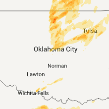
Hail Map for Monday, June 20, 2011

Number of Impacted Households on 6/20/2011
0
Impacted by 1" or Larger Hail
0
Impacted by 1.75" or Larger Hail
0
Impacted by 2.5" or Larger Hail
Square Miles of Populated Area Impacted on 6/20/2011
0
Impacted by 1" or Larger Hail
0
Impacted by 1.75" or Larger Hail
0
Impacted by 2.5" or Larger Hail


Cities Most Affected by Hail Storms of 6/20/2011
| Hail Size | Demographics of Zip Codes Affected | ||||||
|---|---|---|---|---|---|---|---|
| City | Count | Average | Largest | Pop Density | House Value | Income | Age |
| Penokee, KS | 4 | 2.63 | 2.75 | 1 | $41k | $33.1k | 51.4 |
| Grinnell, KS | 2 | 2.75 | 2.75 | 1 | $45k | $40.4k | 50.2 |
| Minneapolis, KS | 3 | 1.75 | 1.75 | 11 | $64k | $35.5k | 41.7 |
| Wichita, KS | 3 | 1.75 | 1.75 | 1582 | $65k | $37.0k | 38.4 |
| Bryson, TX | 2 | 2.25 | 2.75 | 3 | $37k | $28.3k | 39.3 |
| Graham, TX | 2 | 2.13 | 2.50 | 29 | $53k | $32.3k | 41.7 |
| Azle, TX | 2 | 2.00 | 2.00 | 413 | $86k | $43.5k | 41.0 |
| Oakley, KS | 2 | 1.88 | 2.00 | 5 | $57k | $32.4k | 45.3 |
| Manter, KS | 2 | 1.75 | 1.75 | 0 | $75k | $43.8k | 43.6 |
| Springtown, TX | 2 | 1.75 | 1.75 | 180 | $88k | $43.7k | 37.6 |
| Newcastle, TX | 2 | 1.75 | 1.75 | 2 | $27k | $26.7k | 44.0 |
| Graford, TX | 1 | 2.75 | 2.75 | 11 | $89k | $35.0k | 49.1 |
| Amherst, NE | 1 | 2.75 | 2.75 | 4 | $84k | $40.8k | 40.7 |
| Woodson, TX | 1 | 2.50 | 2.50 | 2 | $24k | $27.1k | 46.7 |
| Kearney, NE | 1 | 2.00 | 2.00 | 182 | $89k | $35.1k | 33.5 |
| Clay Center, KS | 1 | 2.00 | 2.00 | 17 | $56k | $35.2k | 44.5 |
| Grand Island, NE | 1 | 1.75 | 1.75 | 265 | $91k | $38.6k | 39.6 |
| Platte Center, NE | 1 | 1.75 | 1.75 | 8 | $68k | $36.8k | 41.1 |
| Sedgwick, CO | 1 | 1.75 | 1.75 | 1 | $50k | $29.4k | 50.6 |
| Lamont, OK | 1 | 1.75 | 1.75 | 3 | $27k | $24.5k | 41.7 |
| Humphrey, NE | 1 | 1.75 | 1.75 | 7 | $82k | $38.0k | 41.1 |
| Walsh, CO | 1 | 1.75 | 1.75 | 0 | $49k | $29.9k | 46.8 |
| Chico, TX | 1 | 1.75 | 1.75 | 25 | $63k | $37.7k | 40.4 |
| Haddam, KS | 1 | 1.75 | 1.75 | 2 | $15k | $25.3k | 52.6 |
| Walters, OK | 1 | 1.75 | 1.75 | 13 | $54k | $30.0k | 39.5 |
| Breckenridge, TX | 1 | 1.75 | 1.75 | 16 | $45k | $29.6k | 39.3 |
| Overton, NE | 1 | 1.75 | 1.75 | 6 | $63k | $34.5k | 37.8 |
| Hoxie, KS | 1 | 1.75 | 1.75 | 2 | $59k | $33.9k | 48.2 |
| Olney, TX | 1 | 1.75 | 1.75 | 15 | $34k | $25.4k | 42.7 |
| Bridgeport, TX | 1 | 1.75 | 1.75 | 81 | $83k | $40.2k | 35.8 |
| Duncan, OK | 1 | 1.75 | 1.75 | 88 | $61k | $31.6k | 40.0 |
| Loving, TX | 1 | 1.75 | 1.75 | 4 | $47k | $33.6k | 47.7 |
| Morrowville, KS | 1 | 1.75 | 1.75 | 2 | $17k | $25.9k | 43.3 |
| Jacksboro, TX | 1 | 1.75 | 1.75 | 9 | $47k | $33.5k | 37.9 |
| Medford, OK | 1 | 1.75 | 1.75 | 4 | $50k | $28.4k | 46.9 |
| Madison, NE | 1 | 1.75 | 1.75 | 9 | $56k | $36.6k | 34.8 |
Hail and Wind Damage Spotted on 6/20/2011
Filter by Report Type:Hail ReportsWind Reports
States Impacted
Kansas, Colorado, Illinois, Indiana, Kentucky, Virginia, Nebraska, Texas, Oklahoma, South Dakota, Iowa, Alabama, Minnesota, Missouri, Ohio, LouisianaKansas
| Local Time | Report Details |
|---|---|
| 12:00 PM UTC | Quarter sized hail reported near Winona, KS, 31 miles SSW of Colby, KS, covering the ground |
| 12:30 PM UTC | Time estimate. couple traffic signs blown dow in logan county KS, 21.2 miles SSE of Colby, KS |
| 12:30 PM UTC | Ping Pong Ball sized hail reported near Oakley, KS, 19.4 miles SSE of Colby, KS |
| 12:30 PM UTC | Hen Egg sized hail reported near Oakley, KS, 21.2 miles SSE of Colby, KS |
| 12:33 PM UTC | Ping Pong Ball sized hail reported near Oakley, KS, 21.2 miles SSE of Colby, KS |
| 12:35 PM UTC | Golf Ball sized hail reported near Oakley, KS, 21.2 miles SSE of Colby, KS |
| 12:52 PM UTC | Baseball sized hail reported near Grinnell, KS, 25.5 miles SE of Colby, KS |
| 12:55 PM UTC | Baseball sized hail reported near Grinnell, KS, 23.8 miles SE of Colby, KS |
| 1:02 PM UTC | Golf Ball sized hail reported near Hoxie, KS, 33.4 miles ESE of Colby, KS |
| 1:50 PM UTC | Golf Ball sized hail reported near Manter, KS, 72.9 miles WSW of Garden City, KS |
| 8:50 AM CDT | Storm damage reported in stanton county KS, 72.9 miles WSW of Garden City, KS |
| 2:00 PM UTC | Golf Ball sized hail reported near Manter, KS, 65.2 miles WSW of Garden City, KS |
| 9:00 AM CDT | Storm damage reported in stanton county KS, 63.3 miles WSW of Garden City, KS |
| 2:01 PM UTC | Half Dollar sized hail reported near , , 53.4 miles W of Garden City, KS |
| 2:15 PM UTC | Golf Ball sized hail reported near , , 52.3 miles W of Garden City, KS, golf ball sized hail was producing damage to automobiles. |
| 9:18 AM CDT | Quarter sized hail reported near Johnson City, KS, 55.3 miles WSW of Garden City, KS |
| 2:20 PM UTC | Quarter sized hail reported near Johnson City, KS, 54.5 miles WSW of Garden City, KS |
| 2:20 PM UTC | Half Dollar sized hail reported near Johnson City, KS, 52.3 miles WSW of Garden City, KS |
| 2:30 PM UTC | Quarter sized hail reported near Ulysses, KS, 43.2 miles SW of Garden City, KS |
| 9:30 AM CDT | Storm damage reported in grant county KS, 43.2 miles SW of Garden City, KS |
| 2:36 PM UTC | Half Dollar sized hail reported near Kendall, KS, 40.1 miles WNW of Garden City, KS |
| 2:46 PM UTC | Quarter sized hail reported near Lakin, KS, 31.1 miles WSW of Garden City, KS |
| 3:03 PM UTC | Quarter sized hail reported near Lakin, KS, 28.1 miles WNW of Garden City, KS, the hail was dime to quarter sized. |
| 6:30 PM UTC | Tennis Ball sized hail reported near Morland, KS, 51.6 miles NW of Hays, KS |
| 6:35 PM UTC | Baseball sized hail reported near Morland, KS, 51.6 miles NW of Hays, KS, baseball size hail mixed with golfballs. hail storm persisted for 10 min. |
| 6:40 PM UTC | Baseball sized hail reported near Morland, KS, 51.6 miles NW of Hays, KS, baseball size hail largest size in yard. mostly golfball size hail. hail storm lasted for 10 min. |
| 6:57 PM UTC | Tennis Ball sized hail reported near Penokee, KS, 53.7 miles NW of Hays, KS, windows all gone on west side of the house. winds estimated at 60mph. |
| 7:20 PM UTC | Multiple power lines dow in graham county KS, 50.4 miles NNW of Hays, KS |
| 8:23 PM UTC | Quarter sized hail reported near Lindsborg, KS, 73.8 miles WSW of Manhattan, KS |
| 8:40 PM UTC | Golf Ball sized hail reported near Minneapolis, KS, 58.9 miles W of Manhattan, KS, delayed reported relayed by nssl severe hazards analysis and verification experiment. |
| 8:41 PM UTC | Half Dollar sized hail reported near , , 63.5 miles W of Manhattan, KS |
| 8:48 PM UTC | Quarter sized hail reported near Bennington, KS, 59.4 miles W of Manhattan, KS, delayed report via nssl severe hazards analysis and verification experiment. |
| 8:50 PM UTC | Quarter sized hail reported near Minneapolis, KS, 58.2 miles W of Manhattan, KS |
| 8:50 PM UTC | 4-5 inch diameter tree limbs down. winds were estimated at 50-60 mp in ottawa county KS, 58.2 miles W of Manhattan, KS |
| 8:51 PM UTC | Half Dollar sized hail reported near , , 57.7 miles WSW of Manhattan, KS, via spotter network |
| 9:01 PM UTC | Half Dollar sized hail reported near Minneapolis, KS, 54.2 miles W of Manhattan, KS, delayed report via nssl severe hazards analysis and verification experiment. |
| 9:01 PM UTC | Golf Ball sized hail reported near Minneapolis, KS, 51.5 miles W of Manhattan, KS, delay report via nssl severe hazards analysis and verification experiment |
| 9:02 PM UTC | Half Dollar sized hail reported near Miltonvale, KS, 53.1 miles W of Manhattan, KS |
| 9:05 PM UTC | Golf Ball sized hail reported near Minneapolis, KS, 51.5 miles W of Manhattan, KS, delayed report via nssl severe hazards analysis and verification experiment. |
| 9:10 PM UTC | Half Dollar sized hail reported near Miltonvale, KS, 51.1 miles W of Manhattan, KS |
| 9:15 PM UTC | Quarter sized hail reported near Clyde, KS, 48.2 miles WNW of Manhattan, KS, delayed report via nssl severe hazards analysis and verification experiment |
| 9:19 PM UTC | Quarter sized hail reported near Miltonvale, KS, 49.1 miles WNW of Manhattan, KS |
| 9:26 PM UTC | Storm damage reported in sheridan county KS, 23.8 miles SE of Colby, KS |
| 9:28 PM UTC | Quarter sized hail reported near Miltonvale, KS, 49.4 miles WNW of Manhattan, KS |
| 9:44 PM UTC | Quarter sized hail reported near Clyde, KS, 53.1 miles WNW of Manhattan, KS |
| 9:49 PM UTC | Quarter sized hail reported near Clyde, KS, 54.9 miles NW of Manhattan, KS |
| 9:51 PM UTC | Quarter sized hail reported near Gypsum, KS, 61.2 miles N of Wichita, KS |
| 9:52 PM UTC | Quarter sized hail reported near Gypsum, KS, 61.1 miles N of Wichita, KS |
| 9:53 PM UTC | Ping Pong Ball sized hail reported near Clyde, KS, 54.9 miles NW of Manhattan, KS |
| 9:57 PM UTC | Half Dollar sized hail reported near Haddam, KS, 56.3 miles NW of Manhattan, KS |
| 10:00 PM UTC | Golf Ball sized hail reported near Haddam, KS, 58.8 miles NW of Manhattan, KS |
| 10:10 PM UTC | Quarter sized hail reported near Haddam, KS, 58.5 miles NW of Manhattan, KS |
| 10:26 PM UTC | Quarter sized hail reported near Miltonvale, KS, 49.6 miles WNW of Manhattan, KS |
| 10:30 PM UTC | Quarter sized hail reported near Minneapolis, KS, 47.7 miles W of Manhattan, KS |
| 10:31 PM UTC | Storm damage reported in dickinson county KS, 39.8 miles WSW of Manhattan, KS |
| 10:35 PM UTC | Ping Pong Ball sized hail reported near Clay Center, KS, 42.7 miles WNW of Manhattan, KS, a west facing window on the house was broken |
| 10:36 PM UTC | Ping Pong Ball sized hail reported near Minneapolis, KS, 44.7 miles W of Manhattan, KS |
| 10:40 PM UTC | Hen Egg sized hail reported near Clay Center, KS, 44.2 miles W of Manhattan, KS |
| 10:40 PM UTC | Storm damage reported in dickinson county KS, 39.8 miles WSW of Manhattan, KS |
| 10:42 PM UTC | Ping Pong Ball sized hail reported near Miltonvale, KS, 45.6 miles WNW of Manhattan, KS, delayed report via nssl severe hazards analysis and verification experiment. |
| 10:45 PM UTC | Quarter sized hail reported near Wichita, KS, 7.2 miles WNW of Wichita, KS, half to 1 inch hail. |
| 10:47 PM UTC | Golf Ball sized hail reported near Morrowville, KS, 63.5 miles NNW of Manhattan, KS |
| 10:51 PM UTC | Quarter sized hail reported near Wichita, KS, 6 miles WSW of Wichita, KS, quarter to half dollar at the nws office. |
| 10:51 PM UTC | Half Dollar sized hail reported near Wichita, KS, 6.2 miles WNW of Wichita, KS |
| 10:52 PM UTC | Semi overturned from high wind in sedgwick county KS, 7.7 miles NW of Wichita, KS |
| 10:53 PM UTC | Quarter sized hail reported near Newton, KS, 24.4 miles N of Wichita, KS |
| 10:55 PM UTC | Roof off a buildin in sedgwick county KS, 10 miles N of Wichita, KS |
| 10:56 PM UTC | Quarter sized hail reported near Newton, KS, 24.3 miles N of Wichita, KS |
| 10:58 PM UTC | Quarter sized hail reported near Wichita, KS, 8 miles WSW of Wichita, KS |
| 10:58 PM UTC | Storm damage reported in sedgwick county KS, 6 miles WSW of Wichita, KS |
| 11:00 PM UTC | Metal shed blown over at hoover and 53r in sedgwick county KS, 7.9 miles N of Wichita, KS |
| 11:00 PM UTC | Golf Ball sized hail reported near Wichita, KS, 9 miles WNW of Wichita, KS, at 29th and maize road. |
| 11:01 PM UTC | Ping Pong Ball sized hail reported near Clearwater, KS, 15.2 miles SW of Wichita, KS |
| 11:01 PM UTC | Reports of power outages in clearwate in sedgwick county KS, 15.2 miles SW of Wichita, KS |
| 11:06 PM UTC | At k-42 and tyler roa in sedgwick county KS, 6.3 miles WSW of Wichita, KS |
| 11:06 PM UTC | 5 power poles down at macarthur and ridge road in sedgwick county KS, 5.8 miles WSW of Wichita, KS |
| 11:07 PM UTC | Estimated 60mph wind gust in harvey county KS, 22.9 miles NNE of Wichita, KS |
| 11:08 PM UTC | Also golf ball hail at hoover and macarthur roa in sedgwick county KS, 5.2 miles SW of Wichita, KS |
| 11:08 PM UTC | Golf Ball sized hail reported near Wichita, KS, 5.2 miles SW of Wichita, KS, also 60 mph winds. at hoover and macarthur road. |
| 11:10 PM UTC | Quarter sized hail reported near Wichita, KS, 0.3 miles NW of Wichita, KS, 3/4 to 1 inch hail falling. |
| 11:10 PM UTC | Golf Ball sized hail reported near Wichita, KS, 6.8 miles W of Wichita, KS, k-42 and west street. |
| 11:10 PM UTC | Storm damage reported in sedgwick county KS, 6 miles WSW of Wichita, KS |
| 11:11 PM UTC | Quarter sized hail reported near Caldwell, KS, 47.5 miles SSW of Wichita, KS, 40 to 50 mph winds. |
| 11:12 PM UTC | Ping Pong Ball sized hail reported near Wichita, KS, 5.2 miles SW of Wichita, KS |
| 11:16 PM UTC | Estimated 60mph winds. pea size hail as wel in marion county KS, 46.3 miles N of Wichita, KS |
| 11:17 PM UTC | Half Dollar sized hail reported near Wichita, KS, 5.7 miles W of Wichita, KS, at friends university. |
| 11:20 PM UTC | 5 power poles down at macarthur and ridge road in sedgwick county KS, 5.8 miles WSW of Wichita, KS |
| 11:24 PM UTC | Storm damage reported in sedgwick county KS, 7.7 miles NE of Wichita, KS |
| 11:29 PM UTC | Rotation in clouds looking north east of 13th and 143rd stree in butler county KS, 10.2 miles E of Wichita, KS |
| 11:44 PM UTC | Half Dollar sized hail reported near Riley, KS, 16.6 miles WNW of Manhattan, KS |
| 11:50 PM UTC | Paint was chipped off of one side of house. 3 inch tree limbs down. dime size hail also reported. radar estimated tim in marshall county KS, 46.5 miles N of Manhattan, KS |
| 11:51 PM UTC | Estimated 60mph winds and 1/2 inch hail in douglas in butler county KS, 21.3 miles ESE of Wichita, KS |
| 11:51 PM UTC | Storm damage reported in cowley county KS, 23 miles SE of Wichita, KS |
| 11:51 PM UTC | 60 to 70 mph winds west side of el dorad in butler county KS, 27.6 miles ENE of Wichita, KS |
| 11:51 PM UTC | 60 to 70 mph winds west side of el dorad in butler county KS, 26.6 miles ENE of Wichita, KS |
| 11:51 PM UTC | Quarter sized hail reported near , , 20 miles ENE of Wichita, KS |
| 11:55 PM UTC | Spotter reports 60 to 70 mph wind in butler county KS, 21 miles ENE of Wichita, KS |
| 11:58 PM UTC | 4 large trees blown down. time estimate in marshall county KS, 45.9 miles N of Manhattan, KS |
| 11:59 PM UTC | Dime size hail as wel in butler county KS, 14.8 miles ESE of Wichita, KS |
| 11:59 PM UTC | Quarter sized hail reported near Udall, KS, 23.2 miles SE of Wichita, KS |
| 12:00 AM UTC | Quarter sized hail reported near Rose Hill, KS, 16.2 miles ESE of Wichita, KS |
| 12:03 AM UTC | Quarter sized hail reported near Douglass, KS, 21.3 miles ESE of Wichita, KS |
| 12:05 AM UTC | Storm damage reported in butler county KS, 30.6 miles ENE of Wichita, KS |
| 12:05 AM UTC | 3 to 4 inch tree limbs down in morris county KS, 45.4 miles SSW of Manhattan, KS |
| 12:05 AM UTC | 5 inch limbs down at 5th and forest. also some half dollar size hai in butler county KS, 21.3 miles ESE of Wichita, KS |
| 12:05 AM UTC | Fence blown down and vinyl trim blown off of a hous in butler county KS, 21.3 miles ESE of Wichita, KS |
| 12:06 AM UTC | Winds 60 to 70 mp in marion county KS, 37 miles NE of Wichita, KS |
| 12:08 AM UTC | Estimated 60 - 70 mph wind in butler county KS, 20 miles ENE of Wichita, KS |
| 12:09 AM UTC | Quarter sized hail reported near Augusta, KS, 19.5 miles E of Wichita, KS |
| 12:12 AM UTC | Storm damage reported in riley county KS, 3.4 miles NW of Manhattan, KS |
| 12:16 AM UTC | Quarter sized hail reported near El Dorado, KS, 30.2 miles ENE of Wichita, KS, hail covering the ground pea to quarter size. |
| 12:20 AM UTC | 50 to 60 mph wind gust in chase county KS, 59.3 miles S of Manhattan, KS |
| 12:22 AM UTC | Quarter sized hail reported near Winfield, KS, 35.1 miles SE of Wichita, KS, quarter size hail east edge of winfield on us160. |
| 12:24 AM UTC | Quarter sized hail reported near Winfield, KS, 35.7 miles SE of Wichita, KS, along highway 160. |
| 12:30 AM UTC | 60 to 70 mph winds. also quarter sized hai in butler county KS, 31.2 miles ESE of Wichita, KS |
| 12:30 AM UTC | Quarter sized hail reported near Leon, KS, 31.2 miles ESE of Wichita, KS, also 60 to 70 mph winds. |
| 12:31 AM UTC | Quarter sized hail reported near Winfield, KS, 34.8 miles SE of Wichita, KS |
| 12:32 AM UTC | Ping Pong Ball sized hail reported near Leon, KS, 31.1 miles E of Wichita, KS, also 50 mph winds. |
| 12:33 AM UTC | Fire chief reported 76mph wind in cowley county KS, 35.4 miles ESE of Wichita, KS |
| 12:35 AM UTC | Storm damage reported in butler county KS, 36.6 miles E of Wichita, KS |
| 12:35 AM UTC | Quarter sized hail reported near Beaumont, KS, 36.6 miles E of Wichita, KS, 50 to 60 mph wind gusts. |
| 12:51 AM UTC | Also nickel to quarter size hai in cowley county KS, 48 miles SSE of Wichita, KS |
| 12:51 AM UTC | Delayed report. 2-3 inch tree limbs reported down in morris county KS, 40.6 miles SSE of Manhattan, KS |
| 12:51 AM UTC | Quarter sized hail reported near Arkansas City, KS, 48 miles SSE of Wichita, KS, also estimated 60 mph winds. |
| 12:53 AM UTC | Quarter sized hail reported near Burden, KS, 40.5 miles SE of Wichita, KS |
| 12:58 AM UTC | Storm damage reported in marshall county KS, 45.3 miles NNE of Manhattan, KS |
| 12:59 AM UTC | Storm damage reported in chase county KS, 55.8 miles S of Manhattan, KS |
| 1:05 AM UTC | Estimated 60mph wind in cowley county KS, 48.7 miles SE of Wichita, KS |
| 1:15 AM UTC | Delayed report of 2-3 inches of limbs dow in coffey county KS, 42.3 miles NNW of Chanute, KS |
| 1:22 AM UTC | Quarter sized hail reported near Emporia, KS, 60.8 miles SSE of Manhattan, KS |
| 1:37 AM UTC | 50 to 60 mph wind gust in elk county KS, 51.6 miles WSW of Chanute, KS |
| 1:40 AM UTC | Delayed repor in brown county KS, 61.5 miles NE of Manhattan, KS |
| 1:48 AM UTC | Tree blown onto deck of hous in lyon county KS, 57 miles SSE of Manhattan, KS |
| 1:49 AM UTC | Quarter sized hail reported near Emporia, KS, 59.5 miles SSE of Manhattan, KS |
| 1:59 AM UTC | Quarter sized hail reported near Cedar Vale, KS, 60.8 miles SE of Wichita, KS, mostly nickel size |
| 2:14 AM UTC | Quarter sized hail reported near Cedar Vale, KS, 60.8 miles SE of Wichita, KS |
| 2:15 AM UTC | 50 to 60 mph wind gust in woodson county KS, 27.3 miles WNW of Chanute, KS |
| 2:15 AM UTC | Delayed report of 2-3 inches of limbs dow in coffey county KS, 42.3 miles NNW of Chanute, KS |
| 2:34 AM UTC | Also nickel size hai in chautauqua county KS, 60.8 miles SW of Chanute, KS |
| 2:34 AM UTC | Quarter sized hail reported near Yates Center, KS, 20.4 miles NW of Chanute, KS, dime to quarter size hail. |
| 2:45 AM UTC | Trees reported blown down...one fell on a car in atchison county KS, 43 miles NW of Kansas City, MO |
| 3:01 AM UTC | 60 to 70 mph winds. also hail ranging from pea to quarter in allen county KS, 17.2 miles N of Chanute, KS |
| 3:23 AM UTC | 50 to 60 mph wind gusts with pea size hai in montgomery county KS, 40.9 miles SSW of Chanute, KS |
| 5:35 AM UTC | Several small trees dow in cherokee county KS, 48.8 miles SE of Chanute, KS |
Colorado
| Local Time | Report Details |
|---|---|
| 12:10 PM UTC | 13 power poles down along highway 9 in kiowa county CO, 86.5 miles WNW of Garden City, KS |
| 1:30 PM UTC | Golf Ball sized hail reported near Sedgwick, CO, 52.2 miles N of Yuma, CO |
| 1:33 PM UTC | Golf Ball sized hail reported near Walsh, CO, 86.9 miles WSW of Garden City, KS |
| 1:34 PM UTC | Quarter sized hail reported near Walsh, CO, 86.9 miles WSW of Garden City, KS |
Illinois
| Local Time | Report Details |
|---|---|
| 12:12 PM UTC | Trees down and across warner bridge road...1 mile north of rt 17. estimated diameter of biggest trees were 12-15 inche in kankakee county IL, 51.6 miles SSW of Chicago, IL |
Indiana
| Local Time | Report Details |
|---|---|
| 12:17 PM UTC | Powerlines down near 350 s and columbus rd. reported at 817 a in shelby county IN, 27.2 miles SE of Indianapolis, IN |
| 12:20 PM UTC | Countless branches down. several 2-3 inch branches blocking some roads. a tree uprooted and landed on a house in bedford bay area. countless powerlines still down. 2.5 in white county IN, 81.7 miles SSE of Chicago, IL |
| 12:33 PM UTC | Trees larger than 6 inches in diameter and branches down throughout idaville in white county IN, 73.4 miles NNW of Indianapolis, IN |
| 12:36 PM UTC | 1 foot diameter tree down with other trees and branches down throughout the town of burnettsville in white county IN, 72.4 miles NNW of Indianapolis, IN |
| 12:46 PM UTC | Trees down in georgetow in cass county IN, 69.6 miles NNW of Indianapolis, IN |
| 12:46 PM UTC | Trees down. power poles snapped. power lines down in the road at 35n and burlington av in cass county IN, 67.5 miles N of Indianapolis, IN |
| 12:50 PM UTC | Trees and power lines dow in decatur county IN, 46.3 miles SE of Indianapolis, IN |
| 1:36 PM UTC | Quarter sized hail reported near Osgood, IN, 42.2 miles W of Cincinnati, OH |
| 2:02 PM UTC | Quarter sized hail reported near Indianapolis, IN, 0.9 miles N of Indianapolis, IN, south side of indianapolis...1 block from university of indianapolis. |
Kentucky
| Local Time | Report Details |
|---|---|
| 1:15 PM UTC | Several trees downed on hwy 119 near little cowan cree in letcher county KY, 48.5 miles NW of Bristol, TN |
Virginia
| Local Time | Report Details |
|---|---|
| 2:15 PM UTC | One tree down on newland hollow r in scott county VA, 18.9 miles W of Bristol, TN |
| 10:37 AM UTC | Quarter sized hail reported near Java, VA, 51 miles SE of Roanoke, VA |
Nebraska
| Local Time | Report Details |
|---|---|
| 2:32 PM UTC | 2-3 inch diameter tree limbs down. pea to penny size hai in howard county NE, 20.7 miles NNW of Grand Island, NE |
| 7:15 PM UTC | Half Dollar sized hail reported near Benkelman, NE, 50.4 miles NNW of Colby, KS |
| 8:03 PM UTC | Storm damage reported in red willow county NE, 59.8 miles NNE of Colby, KS |
| 8:05 PM UTC | Ping Pong Ball sized hail reported near Oxford, NE, 81.8 miles N of Hays, KS |
| 8:44 PM UTC | Ping Pong Ball sized hail reported near Overton, NE, 66.7 miles WSW of Grand Island, NE, dime to ping pong ball size hail 2 to 3 miles southwest of overton on interstate 80. |
| 8:45 PM UTC | Golf Ball sized hail reported near Overton, NE, 64.2 miles W of Grand Island, NE |
| 8:50 PM UTC | Quarter sized hail reported near Overton, NE, 66.7 miles WSW of Grand Island, NE |
| 8:50 PM UTC | Storm damage reported in dawson county NE, 66.2 miles W of Grand Island, NE |
| 8:52 PM UTC | Quarter sized hail reported near Sutherland, NE, 21.9 miles W of North Platte, NE |
| 9:00 PM UTC | Roof damaged in elm cree in buffalo county NE, 56.3 miles WSW of Grand Island, NE |
| 9:11 PM UTC | Semi was overturned on highway 3 in buffalo county NE, 57.8 miles WSW of Grand Island, NE |
| 9:16 PM UTC | Quarter sized hail reported near Gibbon, NE, 32.3 miles WSW of Grand Island, NE |
| 9:16 PM UTC | Baseball sized hail reported near Amherst, NE, 54.6 miles W of Grand Island, NE |
| 9:19 PM UTC | Hen Egg sized hail reported near Kearney, NE, 33.9 miles W of Grand Island, NE |
| 9:35 PM UTC | Quarter sized hail reported near Miller, NE, 55 miles W of Grand Island, NE |
| 9:42 PM UTC | Quarter sized hail reported near Giltner, NE, 14.6 miles SE of Grand Island, NE |
| 9:48 PM UTC | Golf Ball sized hail reported near Grand Island, NE, 5.4 miles SSW of Grand Island, NE, golf ball size hail just north of interstate 80. |
| 9:51 PM UTC | Quarter sized hail reported near Grand Island, NE, 1.6 miles WSW of Grand Island, NE, quarter size hail reported on the northwest part of grand island. |
| 10:00 PM UTC | Quarter sized hail reported near Grand Island, NE, 1.6 miles WSW of Grand Island, NE, quarter size hail southwest side of grand island |
| 10:12 PM UTC | A large tree fell on a house near engleman and abbott roads on the west side of grand islan in hall county NE, 1.6 miles WSW of Grand Island, NE |
| 10:33 PM UTC | Quarter sized hail reported near Endicott, NE, 68.8 miles NNW of Manhattan, KS |
| 10:34 PM UTC | Half Dollar sized hail reported near Bradshaw, NE, 28.5 miles E of Grand Island, NE |
| 10:35 PM UTC | Delayed report. possible tornado damage at davis creek campground. nws storm survey will investigate. time estimated from rada in valley county NE, 40.9 miles NNW of Grand Island, NE |
| 10:54 PM UTC | Half Dollar sized hail reported near Fairbury, NE, 69.3 miles NNW of Manhattan, KS, hail covered the ground. |
| 11:49 PM UTC | Storm damage reported in platte county NE, 53.9 miles NE of Grand Island, NE |
| 11:57 PM UTC | Quarter sized hail reported near Monroe, NE, 53.9 miles NE of Grand Island, NE |
| 12:06 AM UTC | Storm damage reported in madison county NE, 70.7 miles ESE of Oneill, NE |
| 12:10 AM UTC | Golf Ball sized hail reported near Platte Center, NE, 59.9 miles NE of Grand Island, NE |
| 12:13 AM UTC | Storm damage reported in antelope county NE, 43.9 miles SE of Oneill, NE |
| 12:16 AM UTC | Observation at norfolk stefan airpor in madison county NE, 69.6 miles ESE of Oneill, NE |
| 12:27 AM UTC | Quarter sized hail reported near Exeter, NE, 50.6 miles ESE of Grand Island, NE, emergency management reported pea to quarter size hail. |
| 12:27 AM UTC | Several trees down in norfolk. small hail also covered the ground in some area in madison county NE, 69.6 miles ESE of Oneill, NE |
| 12:30 AM UTC | Straight line winds of 70 to 73 miles an hour. two inches of rain fell in 30 minute in antelope county NE, 31.2 miles SE of Oneill, NE |
| 12:30 AM UTC | Many trees and some power lines down. estimated wind speed was 65 mp in madison county NE, 69.6 miles ESE of Oneill, NE |
| 12:30 AM UTC | Many trees and some power lines dow in madison county NE, 69.6 miles ESE of Oneill, NE |
| 12:30 AM UTC | Tree debris on highway 20. wind speed estimated 60 mp in antelope county NE, 28.4 miles ESE of Oneill, NE |
| 12:30 AM UTC | Building torn apart 5 miles south of clearwate in antelope county NE, 34.1 miles SE of Oneill, NE |
| 12:30 AM UTC | Golf Ball sized hail reported near Humphrey, NE, 68.9 miles NE of Grand Island, NE, relayed by broadcast media. |
| 12:35 AM UTC | Farmsteads with significant outbuilding damage north and east of pierc in pierce county NE, 60.5 miles ESE of Oneill, NE |
| 12:38 AM UTC | Golf Ball sized hail reported near Madison, NE, 74.7 miles NE of Grand Island, NE |
| 12:38 AM UTC | Observation at norfolk airpor in madison county NE, 69.6 miles ESE of Oneill, NE |
| 12:40 AM UTC | Several trees and power lines dow in gage county NE, 62.8 miles SSW of Omaha, NE |
| 12:40 AM UTC | Home north of willow lake lost roof. estimated wind speed was 70 mp in pierce county NE, 58.7 miles ESE of Oneill, NE |
| 12:43 AM UTC | Storm damage reported in gage county NE, 62.8 miles SSW of Omaha, NE |
| 12:44 AM UTC | 2 foot diameter trees down. winds estimated at 70 mp in saunders county NE, 27.1 miles SW of Omaha, NE |
| 12:50 AM UTC | Several trees down in town and a farm building moved off its foundation northwest of town. relayed by emergency manager. corrected time of even in cedar county NE, 60.2 miles E of Oneill, NE |
| 12:55 AM UTC | Storm damage reported in saunders county NE, 28.7 miles W of Omaha, NE |
| 12:55 AM UTC | 15 inch diameter trees blown ove in saunders county NE, 24 miles W of Omaha, NE |
| 12:55 AM UTC | Tree down near dispatcher residence northwest of tow in knox county NE, 51.6 miles ENE of Oneill, NE |
| 12:58 AM UTC | Neighbors siding blown of in douglas county NE, 12.6 miles W of Omaha, NE |
| 12:58 AM UTC | Storm damage reported in saunders county NE, 28.7 miles W of Omaha, NE |
| 12:59 AM UTC | Storm damage reported in douglas county NE, 22.2 miles W of Omaha, NE |
| 1:00 AM UTC | Winds at least 70 mph. trees and power lines down...and north side of town without powe in dodge county NE, 31.1 miles WNW of Omaha, NE |
| 1:03 AM UTC | Large tree blown over on highway 12. a 54 mile an hour gust at spotters hous in knox county NE, 61.5 miles ENE of Oneill, NE |
| 1:05 AM UTC | Trees and electrical lines dow in cedar county NE, 69.2 miles SSW of Sioux Falls, SD |
| 1:05 AM UTC | Power out in dodge county NE, 31.1 miles WNW of Omaha, NE |
| 1:17 AM UTC | Near 72 and 68 in douglas county NE, 3.6 miles W of Omaha, NE |
| 1:17 AM UTC | Near 72 and 68 in douglas county NE, 11.8 miles NW of Omaha, NE |
| 1:19 AM UTC | Several trees down in town and a farm building moved off its foundation northwest of town. relayed by emergency manage in cedar county NE, 60.2 miles E of Oneill, NE |
| 1:20 AM UTC | Official observation at eppley airfiel in douglas county NE, 3.6 miles W of Omaha, NE |
| 1:20 AM UTC | Full size trees reported down near bell stree in dodge county NE, 31.1 miles WNW of Omaha, NE |
| 1:30 AM UTC | 8 inch tree limbs down in south omaha at 45th street. wind estimated to be 60 miles an hour plu in douglas county NE, 3.6 miles W of Omaha, NE |
| 1:35 AM UTC | Many trees down in rosali in thurston county NE, 62.5 miles NNW of Omaha, NE |
| 1:36 AM UTC | Storm damage reported in burt county NE, 38.7 miles NNW of Omaha, NE |
| 1:50 AM UTC | Storm damage reported in cass county NE, 23.5 miles S of Omaha, NE |
| 2:00 AM UTC | Numerous trees down...both uprooted and broke in thurston county NE, 70.7 miles WSW of Storm Lake, IA |
Texas
| Local Time | Report Details |
|---|---|
| 10:30 PM UTC | Golf Ball sized hail reported near Newcastle, TX, 52.3 miles SSW of Wichita Falls, TX, called a local gas station... proprietor reported golfball size hail covering the ground. |
| 11:20 PM UTC | Tennis Ball sized hail reported near Woodson, TX, 57.3 miles NE of Abilene, TX, received a call from an idividual 2n of woodson. they reported tennis ball size hail covering the ground. |
| 11:22 PM UTC | Ping Pong Ball sized hail reported near Olney, TX, 41.3 miles SSW of Wichita Falls, TX |
| 11:31 PM UTC | Golf Ball sized hail reported near Olney, TX, 42.8 miles SSW of Wichita Falls, TX, between olney and loving on 114 |
| 11:48 PM UTC | Golf Ball sized hail reported near Newcastle, TX, 56.8 miles SSW of Wichita Falls, TX, near 578 and 179 |
| 12:00 AM UTC | Golf Ball sized hail reported near Jacksboro, TX, 33.8 miles SSE of Wichita Falls, TX |
| 7:13 PM CDT | Golf Ball sized hail reported near Graham, TX, 56 miles S of Wichita Falls, TX, graham |
| 7:18 PM CDT | Ping Pong Ball sized hail reported near Graham, TX, 56 miles S of Wichita Falls, TX, in graham |
| 7:20 PM CDT | Quarter sized hail reported near Graham, TX, 56 miles S of Wichita Falls, TX |
| 7:22 PM CDT | Tennis Ball sized hail reported near Graham, TX, 55.8 miles S of Wichita Falls, TX |
| 12:26 AM UTC | Ping Pong Ball sized hail reported near Newcastle, TX, 50.9 miles SSW of Wichita Falls, TX, newcastle |
| 12:30 AM UTC | Reported roof blown off an attached garage and downed powerlines in young county TX, 56 miles S of Wichita Falls, TX |
| 12:31 AM UTC | Golf Ball sized hail reported near Bryson, TX, 51.4 miles S of Wichita Falls, TX, golfball size hail fell for at least 5 minutes in bryson. |
| 12:36 AM UTC | Quarter sized hail reported near Bryson, TX, 51.4 miles S of Wichita Falls, TX |
| 12:40 AM UTC | Baseball sized hail reported near Bryson, TX, 56.1 miles S of Wichita Falls, TX |
| 1:05 AM UTC | Storm damage reported in young county TX, 40.2 miles SSW of Wichita Falls, TX |
| 1:25 AM UTC | Golf Ball sized hail reported near Breckenridge, TX, 67.3 miles ENE of Abilene, TX, ping pong and golfball size hail covering ground |
| 1:29 AM UTC | Golf Ball sized hail reported near Loving, TX, 44 miles S of Wichita Falls, TX |
| 8:35 PM CDT | Golf Ball sized hail reported near Chico, TX, 57.4 miles SE of Wichita Falls, TX |
| 1:35 AM UTC | Golf Ball sized hail reported near Runaway Bay, TX, 62.6 miles SE of Wichita Falls, TX |
| 1:40 AM UTC | Half Dollar sized hail reported near Bridgeport, TX, 63.5 miles SE of Wichita Falls, TX |
| 9:12 PM CDT | Baseball sized hail reported near Graford, TX, 69 miles SSE of Wichita Falls, TX |
| 2:40 AM UTC | Storm damage reported in cooke county TX, 53 miles NNW of Dallas, TX |
| 2:58 AM UTC | Reported roof/structural damage in wise county TX, 56.1 miles NW of Dallas, TX |
| 3:10 AM UTC | Golf Ball sized hail reported near Springtown, TX, 55 miles W of Dallas, TX, estimated quarter to golf ball sized hail |
| 3:10 AM UTC | Estimated 55-70 mph winds in parker county TX, 55 miles W of Dallas, TX |
| 10:32 PM CDT | Quarter sized hail reported near Ponder, TX, 42.7 miles NW of Dallas, TX, on hwy 380 |
| 3:59 AM UTC | Hen Egg sized hail reported near Azle, TX, 44.2 miles WNW of Dallas, TX, cracked the window on a car and dented the hood of the car. |
| 4:12 AM UTC | Golf Ball sized hail reported near Springtown, TX, 50.3 miles WNW of Dallas, TX |
| 4:18 AM UTC | Auto body roof blown off onto 377 near pilot point in denton county TX, 44 miles NNW of Dallas, TX |
| 4:21 AM UTC | Storm damage reported in grayson county TX, 48 miles N of Dallas, TX |
| 4:21 AM UTC | Hen Egg sized hail reported near Azle, TX, 44.7 miles WNW of Dallas, TX |
| 11:27 PM CDT | Quarter sized hail reported near Haslet, TX, 34.9 miles WNW of Dallas, TX |
| 4:30 AM UTC | Fences down; tree 1 ft diameter broekn; several 8-10 inch trees uprooted in grayson county TX, 46.4 miles N of Dallas, TX |
| 4:33 AM UTC | Quarter sized hail reported near Justin, TX, 36.1 miles WNW of Dallas, TX |
| 5:12 AM UTC | 78 mph wind gust measured by dyess afb awos at 1212 a in taylor county TX, 7.2 miles WSW of Abilene, TX |
| 5:12 AM UTC | 78 mph wind gust measured by dyess afb awos at 1212 a in taylor county TX, 7.2 miles WSW of Abilene, TX |
| 5:12 AM UTC | Storm damage reported in taylor county TX, 7.2 miles WSW of Abilene, TX |
| 5:20 AM UTC | Satellite dishes were damaged by thunderstorm winds at kean radi in taylor county TX, 2.3 miles W of Abilene, TX |
| 5:20 AM UTC | Sign toppled by thunderstorm winds at firestone near south 1st and pioneer. the west to go store on south 1st and leggett had its roof blown off with debris scattered a in taylor county TX, 2.3 miles W of Abilene, TX |
| 5:22 AM UTC | From dyess observation at 1210 am cd in taylor county TX, 0.7 miles E of Abilene, TX |
| 5:22 AM UTC | From dyess observation at 1212 pm cd in taylor county TX, 0.7 miles E of Abilene, TX |
| 5:27 AM UTC | View fire chief reported several power poles down and a metal roof blown off of residence. he also said that bufallo gap also had power poles dow in taylor county TX, 11.1 miles SW of Abilene, TX |
| 6:37 AM UTC | The roof was blown off a condo building on runaway bay d in wise county TX, 62.6 miles SE of Wichita Falls, TX |
| 1:40 AM CDT | Storm damage reported in wise county TX, 63.5 miles SE of Wichita Falls, TX |
| 6:41 AM UTC | Klud in wise county TX, 56.1 miles NW of Dallas, TX |
| 6:45 AM UTC | *** 1 inj *** roof collapse to the sunset inn. 1 person was transported to a hospital after sustaining an injur in wise county TX, 56.1 miles NW of Dallas, TX |
| 7:04 AM UTC | Sustained for several minutes in parker county TX, 53.3 miles WNW of Dallas, TX |
| 2:12 AM CDT | Power out as well in wise county TX, 44 miles WNW of Dallas, TX |
| 7:18 AM UTC | Estimated 55 to 60 mph 11 miles west of denton on hwy 38 in denton county TX, 43.9 miles NW of Dallas, TX |
| 7:18 AM UTC | Roof collapse at lodge condominiums in wise county TX, 62.6 miles SE of Wichita Falls, TX |
| 7:21 AM UTC | 7 miles west of highway 114/fm156 intersection in denton county TX, 37.1 miles WNW of Dallas, TX |
| 7:26 AM UTC | Significant damage from tree blown into residence in wise county TX, 62.6 miles SE of Wichita Falls, TX |
| 7:30 AM UTC | 3-4" trees were snapped at the ground. some branches damaged car in denton county TX, 36.3 miles NW of Dallas, TX |
| 2:30 AM CDT | Quarter sized hail reported near Double Oak, TX, 26.7 miles NW of Dallas, TX, hail; a trees and tree limbs down; fences knocked over; minor street flooding |
| 2:30 AM CDT | Quarter sized hail reported near Denton, TX, 36.3 miles NW of Dallas, TX |
| 2:32 AM CDT | Quarter sized hail reported near Fort Worth, TX, 31.1 miles WNW of Dallas, TX |
| 7:34 AM UTC | Kdto in denton county TX, 36.8 miles NW of Dallas, TX |
| 7:35 AM UTC | Peak wind measured by asos at kdt in denton county TX, 36.8 miles NW of Dallas, TX |
| 2:35 AM CDT | 2-3 10 inch diameter oak trees were snapped just above the groun in denton county TX, 32.5 miles NW of Dallas, TX |
| 2:42 AM CDT | Ping Pong Ball sized hail reported near Denton, TX, 35.1 miles NW of Dallas, TX |
| 2:45 AM CDT | Ping Pong Ball sized hail reported near Flower Mound, TX, 24.4 miles NW of Dallas, TX |
| 7:45 AM UTC | Storm damage reported in denton county TX, 30.2 miles NNW of Dallas, TX |
| 7:46 AM UTC | 2 to 3 foot diamter tree was uprooted and shingles have been torn off of roofs in denton county TX, 30.2 miles NNW of Dallas, TX |
| 2:54 AM CDT | Storm damage reported in denton county TX, 24.3 miles NW of Dallas, TX |
| 7:56 AM UTC | Large limbs down in denton county TX, 24.4 miles NW of Dallas, TX |
| 8:00 AM UTC | 6-10 inch diameter branches were snapped off trees in hebron and carrolton in denton county TX, 18 miles NNW of Dallas, TX |
| 3:03 AM CDT | Quarter sized hail reported near Lewisville, TX, 23.4 miles NNW of Dallas, TX, at fm 407 and i35e |
| 8:09 AM UTC | Storm damage reported in denton county TX, 25.7 miles N of Dallas, TX |
| 3:36 AM CDT | Quarter sized hail reported near Dallas, TX, 7.9 miles NW of Dallas, TX, at loop 12 and i-35 e northwest of love field |
| 9:45 AM UTC | Tree down b in red river county TX, 82.2 miles SE of Atoka, OK |
| 9:45 AM UTC | Trees down in franklin county TX, 88.4 miles SE of Atoka, OK |
| 10:05 AM UTC | Limb fell and damaged power lin in titus county TX, 84.5 miles SW of Nashville, AR |
Oklahoma
| Local Time | Report Details |
|---|---|
| 10:47 PM UTC | Golf Ball sized hail reported near Medford, OK, 59.3 miles SSW of Wichita, KS, hail was nearly covering the ground. |
| 11:20 PM UTC | Storm damage reported in grant county OK, 64.3 miles SSW of Wichita, KS |
| 11:46 PM UTC | Quarter sized hail reported near Comanche, OK, 44 miles NE of Wichita Falls, TX |
| 11:48 PM UTC | Golf Ball sized hail reported near Duncan, OK, 52 miles NE of Wichita Falls, TX, hwy 81 |
| 11:51 PM UTC | Golf Ball sized hail reported near Walters, OK, 35.6 miles NNE of Wichita Falls, TX, nr hwy 53 and 65 |
| 11:55 PM UTC | Kend asos measured a 58 mph wind gust in garfield county OK, 65.7 miles NNW of Oklahoma City, OK |
| 11:58 PM UTC | Golf Ball sized hail reported near Lamont, OK, 69.9 miles S of Wichita, KS, hail ranging from pea to golf ball size reported along highway 60 in lamont. |
| 12:36 AM UTC | Quarter sized hail reported near Garber, OK, 63.4 miles N of Oklahoma City, OK, hwy 74 and 412 |
| 1:50 AM UTC | Quarter sized hail reported near Perry, OK, 57.9 miles NNE of Oklahoma City, OK, delayed report via perry pd. |
| 2:05 AM UTC | Foraker mesonet site m64 mp in osage county OK, 53.4 miles NNW of Tulsa, OK |
| 2:26 AM UTC | Large tree limb snapped in osage county OK, 59.1 miles NNW of Tulsa, OK |
| 3:00 AM UTC | Wynona mesonet sit in osage county OK, 31.4 miles NW of Tulsa, OK |
| 3:07 AM UTC | 65-70 mph in lincoln county OK, 39.8 miles NE of Oklahoma City, OK |
| 3:07 AM UTC | Quarter sized hail reported near Carney, OK, 39.8 miles NE of Oklahoma City, OK |
| 3:14 AM UTC | Quarter sized hail reported near Agra, OK, 47.9 miles NE of Oklahoma City, OK |
| 3:16 AM UTC | Storm damage reported in payne county OK, 45 miles WSW of Tulsa, OK |
| 10:46 PM CDT | Ping Pong Ball sized hail reported near Mannford, OK, 20 miles W of Tulsa, OK, ping pong ball sized hail covering the ground in man |
| 4:00 AM UTC | Quarter sized hail reported near Tulsa, OK, 7.6 miles SSW of Tulsa, OK, quarter sized hail in prattville. |
| 4:22 AM UTC | Quarter sized hail reported near Tulsa, OK, 5.4 miles ESE of Tulsa, OK, reported at 36th and memorial |
| 4:39 AM UTC | Large tree limbs down...fireworks tent partially collapsed near 111th and olive in tulsa county OK, 14.1 miles SE of Tulsa, OK |
| 4:45 AM UTC | Large tree limbs down greater than 2 inches in dia in mayes county OK, 39.2 miles ENE of Tulsa, OK |
| 4:47 AM UTC | Large tree limbs down in roadway in craig county OK, 57.9 miles NE of Tulsa, OK |
| 4:55 AM UTC | Storm damage reported in bryan county OK, 33.5 miles SSW of Atoka, OK |
| 5:00 AM UTC | Large tree limbs in mayes county OK, 43.4 miles E of Tulsa, OK |
| 5:11 AM UTC | Storm damage reported in craig county OK, 54 miles NE of Tulsa, OK |
| 5:15 AM UTC | Power pole and numerous large tree limbs blown down in community of blue jacke in craig county OK, 63.8 miles SSE of Chanute, KS |
| 5:29 AM UTC | One power pole snapped and three leaning over in mayes county OK, 42.1 miles ENE of Tulsa, OK |
| 5:30 AM UTC | Stadium light pole blown over and knocked over several other light poles. a tree that was blown over took out power line in ottawa county OK, 64.3 miles SSE of Chanute, KS |
| 5:35 AM UTC | Downed trees reported on perry street in bryan county OK, 27.1 miles S of Atoka, OK |
| 5:52 AM UTC | Estimated wind gust of 65 mph with 6 to 12 inch diameter tree limbs broken/downed. 1 power pole broken and 1 home struck by lightnin in craig county OK, 64.4 miles SSE of Chanute, KS |
South Dakota
| Local Time | Report Details |
|---|---|
| 1:25 AM UTC | Power lines down. large tree limbs down that required street department remova in yankton county SD, 56.1 miles SW of Sioux Falls, SD |
| 1:42 AM UTC | Branches down and power outage from downed powerlines in hutchinson county SD, 47.6 miles WSW of Sioux Falls, SD |
| 1:45 AM UTC | Large branches down and power outage from powerlines down in hutchinson county SD, 51.7 miles WSW of Sioux Falls, SD |
| 1:50 AM UTC | Large tree branches down in hutchinson county SD, 37.6 miles WSW of Sioux Falls, SD |
Iowa
| Local Time | Report Details |
|---|---|
| 1:30 AM UTC | Trees and power lines dow in harrison county IA, 27.3 miles NNE of Omaha, NE |
| 1:30 AM UTC | Trees and power lines down in missouri valle in harrison county IA, 20.8 miles N of Omaha, NE |
| 1:43 AM UTC | A tree fell on a hous in monona county IA, 46.8 miles N of Omaha, NE |
| 1:43 AM UTC | Just southwest of mapleton a grain bin was blown across highwa in monona county IA, 44.6 miles SW of Storm Lake, IA |
| 1:45 AM UTC | 1 large tree blown dow in harrison county IA, 39.7 miles N of Omaha, NE |
| 2:04 AM UTC | Storm damage reported in woodbury county IA, 59.5 miles WSW of Storm Lake, IA |
| 2:10 AM UTC | Trained spotter reports wind gusts of at least 60 mph with storm front. time estimated from rada in crawford county IA, 39.6 miles SW of Storm Lake, IA |
| 2:12 AM UTC | Storm damage reported in woodbury county IA, 43.4 miles SW of Storm Lake, IA |
| 2:12 AM UTC | Just southwest of mapleton a semi was blown over on hwy 141 and a grain bin was blown across hwy 14 in monona county IA, 44.6 miles SW of Storm Lake, IA |
| 2:20 AM UTC | *** 2 inj *** roof torn off 3 homes...and around 40 more homes with major roof damage. significant tree damage in town. 4 campers destroyed at the fairgrounds...with 2 in woodbury county IA, 45.6 miles WSW of Storm Lake, IA |
| 2:24 AM UTC | Storm damage reported in montgomery county IA, 34.9 miles ESE of Omaha, NE |
| 2:30 AM UTC | Large tree branches blown down in battle creek and a lose of powe in ida county IA, 30.4 miles SW of Storm Lake, IA |
| 2:30 AM UTC | 6-12 inch diameter branches down...roads closed due to downed tree branches in ida county IA, 20.4 miles WSW of Storm Lake, IA |
| 2:45 AM UTC | Tree toppled and a few branches broken on nearby trees. observed near the airport. time estimated from rada in cass county IA, 47.3 miles ENE of Omaha, NE |
| 2:53 AM UTC | Spotter estimated up to 60 mph gusts and reports 3 to 6 inch branches dow in cass county IA, 55.7 miles E of Omaha, NE |
| 3:00 AM UTC | 2 to 3 foot trees downed. some trees on car in plymouth county IA, 49.4 miles SSE of Sioux Falls, SD |
| 3:00 AM UTC | Machine shed roof damage on white ave as well as trees down on houses and across roads in osceola county IA, 46.1 miles NNW of Storm Lake, IA |
| 3:04 AM UTC | Multiple moderate sized tree limbs down in town. time based on radar in adams county IA, 65.4 miles ESE of Omaha, NE |
| 3:10 AM UTC | Large trees down in o'brien county IA, 26.9 miles NW of Storm Lake, IA |
| 3:12 AM UTC | Local law enforcement reports a power line and fencing blown down near the 1500 block of highway 71 in carrol in carroll county IA, 43.1 miles SSE of Storm Lake, IA |
| 3:15 AM UTC | Trees down in o'brien county IA, 37.5 miles NW of Storm Lake, IA |
| 3:25 AM UTC | Two hog confinements had partial roof damag in o'brien county IA, 35.6 miles NNW of Storm Lake, IA |
| 3:30 AM UTC | Part of a machine shed roof torn off in o'brien county IA, 40 miles NNW of Storm Lake, IA |
| 3:33 AM UTC | Quarter sized hail reported near Lake City, IA, 35.5 miles SE of Storm Lake, IA, extremely heavy rain |
| 3:35 AM UTC | Two hog confinements had partial roof damag in o'brien county IA, 35.6 miles NNW of Storm Lake, IA |
| 3:42 AM UTC | Tree damage in spencer due to strong wind in clay county IA, 36.2 miles N of Storm Lake, IA |
| 3:45 AM UTC | Machine shed roof damage on white ave as well as trees down on houses and across roads in osceola county IA, 46.1 miles NNW of Storm Lake, IA |
| 3:50 AM UTC | 3 stall garage moved off foundation in osceola county IA, 57 miles NNW of Storm Lake, IA |
| 4:00 AM UTC | Nickel hail reported as wel in pocahontas county IA, 28.3 miles ENE of Storm Lake, IA |
| 4:10 AM UTC | Several 6 inch tree limbs down in town. time based on rada in pocahontas county IA, 36 miles ENE of Storm Lake, IA |
| 4:18 AM UTC | Powerlines and trees blown down. estimate 80 mph winds. pea size hail also reporte in humboldt county IA, 47.1 miles ENE of Storm Lake, IA |
| 4:30 AM UTC | Surveyed by emergency manager. one third of roof of quonset storage building torn off. landed to the north of the buildin in kossuth county IA, 51 miles ENE of Storm Lake, IA |
| 4:30 AM UTC | Surveyed by emergency manager. three fourths of grove of trees down. shingle damage to house. debris to nort in kossuth county IA, 50.1 miles ENE of Storm Lake, IA |
| 4:48 AM UTC | 66ft wide by 76 ft long by 50 ft high barn destroyed. grain bin blown off its concrete pad. debris in yard. grass and corn uprooted and blown across highwa in emmet county IA, 63.5 miles NE of Storm Lake, IA |
| 5:30 AM UTC | Six and one half inch diameter branch down outside the radio statio in cerro gordo county IA, 0.2 miles NNE of Mason City, IA |
| 5:30 AM UTC | Small tree 8 to 10 inches in diameter snapped off at the bas in jasper county IA, 29.5 miles E of Des Moines, IA |
| 5:45 AM UTC | Trees down in town. heard over scanne in butler county IA, 42.4 miles SSE of Mason City, IA |
| 6:10 AM UTC | Many branches down. gazebo blown apart and debris strewn along a southwest to northeast path approximately 75 feet long. some debris and grass embedded 4 to 6 inches in in poweshiek county IA, 43.9 miles WSW of Cedar Rapids, IA |
| 6:10 AM UTC | Many branches down. gazebo blown apart. time estimated. from who t in poweshiek county IA, 43.9 miles WSW of Cedar Rapids, IA |
| 6:15 AM UTC | Farm site on highway v18 with large trees down. minor damage to house with gutter blown into truck. roof off outbuilding. in clutier numerous large tree limbs also down in tama county IA, 37.7 miles WNW of Cedar Rapids, IA |
| 6:20 AM UTC | Storm damage reported in floyd county IA, 26.9 miles E of Mason City, IA |
| 6:30 AM UTC | A number of 1 to 3 foot diameter trees down across the cit in floyd county IA, 26.9 miles E of Mason City, IA |
| 6:30 AM UTC | Aluminum machine shed ripped off its foundation and blown anticyclonically north and east and destroyed. debris from the shed then continued on an anticyclonic path and in black hawk county IA, 38.4 miles NW of Cedar Rapids, IA |
| 6:30 AM UTC | Damage to a couple of barns. small outbuilding blown across the road and wrapped around a tre in black hawk county IA, 38.4 miles NW of Cedar Rapids, IA |
Alabama
| Local Time | Report Details |
|---|---|
| 2:58 AM UTC | In the crossville community...30 trees were downed along with other trees elsewhere in the area. a large limb fell through the roof of a home in the same are in lamar county AL, 50.5 miles ENE of Starkville, MS |
Minnesota
| Local Time | Report Details |
|---|---|
| 4:00 AM UTC | Bent metal flag pole in nobles county MN, 63.1 miles NNW of Storm Lake, IA |
Missouri
| Local Time | Report Details |
|---|---|
| 4:04 AM UTC | Storm damage reported in caldwell county MO, 53.9 miles NE of Kansas City, MO |
| 4:10 AM UTC | Storm damage reported in daviess county MO, 64.9 miles NNE of Kansas City, MO |
| 4:15 AM UTC | Tree down in daviess county MO, 61.3 miles NNE of Kansas City, MO |
| 6:00 AM UTC | Minor roof damage reported to a few structures in the city of jasper. one outbuilding had some tin roof panels removed. large limbs were removed from a few trees. at le in jasper county MO, 56.3 miles W of Springfield, MO |
| 6:11 AM UTC | Several calls about tree limbs blown down onto power lines. one house also lost a few shingles. measured wind speeds throughout area 36 to 46 mp in boone county MO, 0.3 miles SE of Columbia, MO |
| 6:35 AM UTC | Report relayed through county emergency managemen in barry county MO, 40.5 miles WSW of Springfield, MO |
Ohio
| Local Time | Report Details |
|---|---|
| 10:59 AM UTC | One tree down on power lines along us 22 in pickaway county OH, 24.8 miles SSE of Columbus, OH |
Louisiana
| Local Time | Report Details |
|---|---|
| 11:58 AM UTC | A tree was downed across highway 471 east of the verda communit in grant county LA, 81.1 miles SE of Shreveport, LA |
Connect with Interactive Hail Maps