

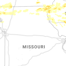
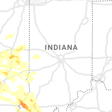
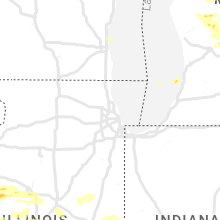
Hail Map for Thursday, June 29, 2023

Number of Impacted Households on 6/29/2023
0
Impacted by 1" or Larger Hail
0
Impacted by 1.75" or Larger Hail
0
Impacted by 2.5" or Larger Hail
Square Miles of Populated Area Impacted on 6/29/2023
0
Impacted by 1" or Larger Hail
0
Impacted by 1.75" or Larger Hail
0
Impacted by 2.5" or Larger Hail


Cities Most Affected by Hail Storms of 6/29/2023
| Hail Size | Demographics of Zip Codes Affected | ||||||
|---|---|---|---|---|---|---|---|
| City | Count | Average | Largest | Pop Density | House Value | Income | Age |
| Westpoint, TN | 2 | 2.25 | 2.75 | 15 | $56k | $28.5k | 42.1 |
| Berry, AL | 2 | 1.88 | 2.00 | 19 | $61k | $27.1k | 39.5 |
| Noble, IL | 2 | 1.88 | 2.00 | 13 | $54k | $33.3k | 40.4 |
| Oakland City, IN | 1 | 1.75 | 1.75 | 54 | $65k | $32.0k | 40.4 |
| Mount Carmel, IL | 1 | 1.75 | 1.75 | 67 | $59k | $34.8k | 42.4 |
| Mount Hope, AL | 1 | 1.75 | 1.75 | 23 | $72k | $36.8k | 38.6 |
| Moulton, AL | 1 | 1.75 | 1.75 | 66 | $78k | $31.5k | 40.8 |
| Terre Haute, IN | 1 | 1.75 | 1.75 | 200 | $83k | $36.0k | 37.8 |
| Glendo, WY | 1 | 1.75 | 1.75 | 0 | $80k | $23.0k | 52.4 |
| Denver, CO | 1 | 1.75 | 1.75 | 5097 | $156k | $37.4k | 37.8 |
| Laramie, WY | 1 | 1.75 | 1.75 | 66 | $120k | $25.8k | 25.5 |
Hail and Wind Damage Spotted on 6/29/2023
Filter by Report Type:Hail ReportsWind Reports
States Impacted
Illinois, Nebraska, Kansas, Missouri, Iowa, Indiana, Kentucky, Tennessee, Wisconsin, Wyoming, Alabama, Michigan, Utah, Colorado, South CarolinaIllinois
| Local Time | Report Details |
|---|---|
| 7:00 AM CDT | Ping Pong Ball sized hail reported near Ashmore, IL, 18.8 miles E of Mattoon, IL, time estimated by radar. |
| 8:20 AM CDT | Quarter sized hail reported near Petersburg, IL, 49.2 miles SSW of Peoria, IL |
| 9:04 AM CDT | Quarter sized hail reported near Tuscola, IL, 21 miles N of Mattoon, IL, report from mping: quarter (1.00 in.). |
| 10:09 AM CDT | Several trees damaged and trunks snapped in good hope. winds estimated near 100 mph. time estimated from rada in mcdonough county IL, 56.1 miles E of Kahoka, MO |
| 10:11 AM CDT | Farm outbuilding destroyed. winds estimated near 100 mph. time estimated from rada in warren county IL, 57 miles W of Peoria, IL |
| 10:20 AM CDT | Several large tree branches snapped in roseville. winds estimated near 100 mph. time estimated from rada in warren county IL, 56.4 miles W of Peoria, IL |
| 10:30 AM CDT | Several large to very large tree branches down. trees snapped as well. time estimated by rada in hancock county IL, 20.1 miles E of Kahoka, MO |
| 10:38 AM CDT | Cannot see neighbors hous in hancock county IL, 20.5 miles E of Kahoka, MO |
| 10:40 AM CDT | Major tree damage reported throughout tow in hancock county IL, 20 miles ENE of Kahoka, MO |
| 10:43 AM CDT | Roof ripped off of mobile home... several injuries per em. time estimated from rada in hancock county IL, 29.2 miles E of Kahoka, MO |
| 10:45 AM CDT | Grain bin destroyed and rolled into field. winds estimated at 100 mph. time estimated based on rada in hancock county IL, 31.3 miles ENE of Kahoka, MO |
| 10:50 AM CDT | 30 inch tree snapped at bas in adams county IL, 38.3 miles SSE of Kahoka, MO |
| 10:53 AM CDT | Several trees across roadwa in hancock county IL, 30.6 miles E of Kahoka, MO |
| 10:54 AM CDT | Time estimated by radar. two 18 inch diameter trees downed. numerous tree blanches down. one of the worst storms experienced in 78 yr in hancock county IL, 40.1 miles ENE of Kahoka, MO |
| 10:55 AM CDT | Garage outbuilding destroyed... winds estimated at 100 mph. time estimated by rada in hancock county IL, 41 miles ENE of Kahoka, MO |
| 10:56 AM CDT | Farm outbuilding destroyed... winds estimated around 90-100 mph. time estimated on rada in hancock county IL, 42.5 miles ENE of Kahoka, MO |
| 10:58 AM CDT | Time estimated by rada in hancock county IL, 34.5 miles ENE of Kahoka, MO |
| 10:58 AM CDT | Several tree trunks snapped near the twin oaks golf and country club. winds estimated near 100 mph. time estimated on rada in mcdonough county IL, 45.3 miles ENE of Kahoka, MO |
| 11:00 AM CDT | Full size barn flattened to ground... full size trees up rooted laying to the eas in hancock county IL, 27.9 miles ENE of Kahoka, MO |
| 11:00 AM CDT | Extensive tree damage throughout town. winds were strong for about 20 minutes beginning around 11 am. time estimated by rada in hancock county IL, 31.1 miles E of Kahoka, MO |
| 11:02 AM CDT | Trained spotter reported snapped power poles... lots of trees down... and some barns blown over between durham and laharpe. winds were estimated over 80 miles per hou in hancock county IL, 38.4 miles ENE of Kahoka, MO |
| 11:03 AM CDT | Storm damage reported in mcdonough county IL, 47.9 miles E of Kahoka, MO |
| 11:05 AM CDT | Home weather station with a gust around 90 mph... estimated up to 10 in hancock county IL, 29.8 miles ENE of Kahoka, MO |
| 11:05 AM CDT | Several tree trunks snapped. winds estimated near 100 mph. time estimated from rada in mcdonough county IL, 52.4 miles E of Kahoka, MO |
| 11:10 AM CDT | Reports of substantial tree damage around the wiu campus in macomb. power lines are down... some of which are still liv in mcdonough county IL, 54.9 miles E of Kahoka, MO |
| 11:13 AM CDT | 80 plus mph wind... mature evergreens snapped at bas in mcdonough county IL, 54.9 miles E of Kahoka, MO |
| 11:15 AM CDT | Time estimated. tree on house. power lines dow in mcdonough county IL, 55.4 miles E of Kahoka, MO |
| 11:16 AM CDT | Storm damage reported in schuyler county IL, 53.5 miles ESE of Kahoka, MO |
| 11:16 AM CDT | Report from mping: 3-inch tree limbs broken; power poles broke in mcdonough county IL, 56.1 miles E of Kahoka, MO |
| 11:16 AM CDT | 88 mph measured wind gust. 15 minutes of gusts over 70 mph. rv flippe in mcdonough county IL, 55.6 miles E of Kahoka, MO |
| 11:20 AM CDT | Corrects previous tstm wnd gst report from roseville. several large tree branches snapped in roseville. winds estimated near 100 mph. time estimated from rada in warren county IL, 56.4 miles W of Peoria, IL |
| 11:20 AM CDT | Numerous trees and power lines were blown dow in fulton county IL, 44.8 miles W of Peoria, IL |
| 11:25 AM CDT | Report from mping: 3-inch tree limbs broken; power poles broken. time estimated from rada in warren county IL, 56.8 miles ENE of Kahoka, MO |
| 11:26 AM CDT | Railroad gate snapped off by strong wind in mcdonough county IL, 55.4 miles E of Kahoka, MO |
| 11:30 AM CDT | Report of lots of trees down in town... including pictures relayed of metal roof peeled off of a shed. time estimated by rada in mcdonough county IL, 49 miles WSW of Peoria, IL |
| 11:32 AM CDT | Trees and power lines reported down throughout the northern end of the county. time of arrival at perry estimated from rada in pike county IL, 68.2 miles SE of Kahoka, MO |
| 11:35 AM CDT | Trees and power lines reported down throughout the county. time of arrival at pittsfield estimated from rada in pike county IL, 73.9 miles SE of Kahoka, MO |
| 11:35 AM CDT | Report of a few trees down near versailles. time estimated from rada in brown county IL, 67.4 miles ESE of Kahoka, MO |
| 11:35 AM CDT | Report from mping: 3-inch tree limbs broken; power poles broke in mcdonough county IL, 58.2 miles E of Kahoka, MO |
| 11:35 AM CDT | Storm damage reported in fulton county IL, 32 miles W of Peoria, IL |
| 11:35 AM CDT | Storm damage reported in fulton county IL, 36.5 miles WSW of Peoria, IL |
| 11:35 AM CDT | 6 inch diameter tree snapped. time estimated by rada in fulton county IL, 34.9 miles WSW of Peoria, IL |
| 11:35 AM CDT | 8 to 10 inch tree limbs down in cuba. time estimated by rada in fulton county IL, 34.6 miles WSW of Peoria, IL |
| 11:36 AM CDT | Large tree... approximately one foot in diameter... down on east side of cub in fulton county IL, 33.6 miles WSW of Peoria, IL |
| 11:37 AM CDT | Tree down north of monmouth on hwy 67... time estimated from rada in warren county IL, 58.3 miles WNW of Peoria, IL |
| 11:40 AM CDT | Report from mping: 1-inch tree limbs broken; shingles blown of in fulton county IL, 35.8 miles SW of Peoria, IL |
| 11:40 AM CDT | Storm damage reported in fulton county IL, 25.5 miles WSW of Peoria, IL |
| 11:43 AM CDT | Small trees down at intersection of highway 41 and 11 in knox county IL, 43.3 miles W of Peoria, IL |
| 11:43 AM CDT | Several trees down across town with 2 ft diameter or greater. roof damage to multiple home in morgan county IL, 73.7 miles ESE of Kahoka, MO |
| 11:52 AM CDT | Tree down on a truc in morgan county IL, 74.6 miles SSW of Peoria, IL |
| 11:52 AM CDT | A large tree branch was blown dow in peoria county IL, 15.4 miles W of Peoria, IL |
| 11:53 AM CDT | Corrects location. tree down near interstate 280 near quad cities international airport. time estimated from rada in rock island county IL, 69.9 miles ESE of Cedar Rapids, IA |
| 11:53 AM CDT | Numerous reports of trees and power lines down throughout the county north of 2 miles south of hardi in calhoun county IL, 46.6 miles NNW of Saint Louis, MO |
| 11:54 AM CDT | Wind gust measured on mobile anemometer between galesburg and wataga. some corn stalks bent ove in knox county IL, 44 miles WNW of Peoria, IL |
| 11:54 AM CDT | Several branches dow in morgan county IL, 74.6 miles SSW of Peoria, IL |
| 11:54 AM CDT | Machine shed partially collapsed at the intersection of old airport rd. and sheehan r in morgan county IL, 72 miles N of Saint Louis, MO |
| 11:55 AM CDT | Large tree snapped about half way up trun in morgan county IL, 74.7 miles N of Saint Louis, MO |
| 11:57 AM CDT | Trees reported down throughout the county. in white hall... there were a few power lines brought down as well. time of arrival at white hall estimated from rada in greene county IL, 57.1 miles N of Saint Louis, MO |
| 12:02 PM CDT | Swop member reported 8-10 power poles snapped along dirksen pkwy from thunderstorm wind in sangamon county IL, 63.6 miles S of Peoria, IL |
| 12:03 PM CDT | Storm damage reported in peoria county IL, 5.4 miles W of Peoria, IL |
| 12:05 PM CDT | Reported at fondulac par in tazewell county IL, 2.3 miles S of Peoria, IL |
| 12:05 PM CDT | Storm damage reported in tazewell county IL, 8.4 miles S of Peoria, IL |
| 12:05 PM CDT | 5 to 8 inch tree limbs snapped near salisbury... and one tree uproote in sangamon county IL, 57.3 miles SSW of Peoria, IL |
| 12:05 PM CDT | A tree was blown down across the street from holy family schoo in peoria county IL, 3.4 miles NW of Peoria, IL |
| 12:05 PM CDT | A large tree and several tree branches were blown down in pekin par in tazewell county IL, 8.7 miles SSW of Peoria, IL |
| 12:07 PM CDT | Large tree blown over... approximately 18 inches in diameter. time estimated by rada in peoria county IL, 6.4 miles NW of Peoria, IL |
| 12:07 PM CDT | Large branch down... approximately five inches in diamete in peoria county IL, 6.6 miles NW of Peoria, IL |
| 12:10 PM CDT | Storm damage reported in tazewell county IL, 5.7 miles E of Peoria, IL |
| 12:14 PM CDT | Storm damage reported in tazewell county IL, 10.2 miles SE of Peoria, IL |
| 12:15 PM CDT | A home was heavily damaged on curran road south of county road 5 1/2 south. possibly caused by a tornad in sangamon county IL, 67.8 miles S of Peoria, IL |
| 12:15 PM CDT | One foot diameter tree snapped in half... just north of i-7 in sangamon county IL, 65.9 miles S of Peoria, IL |
| 12:15 PM CDT | A large tree branch was blown dow in tazewell county IL, 9.4 miles E of Peoria, IL |
| 12:15 PM CDT | Trees and power lines down throughout the county north of highway 16. at virden... live power lines were down across a residence. time represents beginning of damage in in macoupin county IL, 48.2 miles NNE of Saint Louis, MO |
| 12:15 PM CDT | Report from mping: 3-inch tree limbs broken. time estimated by rada in peoria county IL, 8.9 miles WNW of Peoria, IL |
| 12:15 PM CDT | Large tree down blocking subdivision roa in sangamon county IL, 70.1 miles S of Peoria, IL |
| 12:15 PM CDT | Storm damage reported in tazewell county IL, 8.9 miles SE of Peoria, IL |
| 12:15 PM CDT | At least 15 power poles down. time estimated by rada in sangamon county IL, 64.3 miles S of Peoria, IL |
| 12:15 PM CDT | Five inch diameter tree branch snapped. time estimated by rada in peoria county IL, 8.2 miles N of Peoria, IL |
| 12:15 PM CDT | Six to eight inch diameter branch blown off of healthy tree... blocking crestwood driv in peoria county IL, 3.4 miles NNE of Peoria, IL |
| 12:15 PM CDT | Tree down on a car and power lines. time estimated by rada in peoria county IL, 2.8 miles NNE of Peoria, IL |
| 12:15 PM CDT | Major structural damage with significant roof loss. possibly caused by a tornad in sangamon county IL, 66.4 miles S of Peoria, IL |
| 12:17 PM CDT | Storm damage reported in sangamon county IL, 59 miles S of Peoria, IL |
| 12:18 PM CDT | Report from mping: trees uprooted or snapped. possibly caused by a tornad in sangamon county IL, 70.1 miles S of Peoria, IL |
| 12:19 PM CDT | Two trees were blown ove in sangamon county IL, 65.7 miles S of Peoria, IL |
| 12:20 PM CDT | Several large tree branches down. time estimated from rada in sangamon county IL, 64.3 miles WNW of Mattoon, IL |
| 12:20 PM CDT | Large tree blown down onto a chain link fence... destroying the fence. time estimated by rada in sangamon county IL, 61.6 miles S of Peoria, IL |
| 12:20 PM CDT | Camper rolled into a house... with shingles blown off the house. possibly caused by a tornad in sangamon county IL, 70.2 miles S of Peoria, IL |
| 12:20 PM CDT | Several large trees down. several houses with shingle damage. possibly caused by a tornado. time estimated by rada in sangamon county IL, 70.3 miles W of Mattoon, IL |
| 12:20 PM CDT | Large trees dow in macoupin county IL, 61 miles NNE of Saint Louis, MO |
| 12:20 PM CDT | Large tree limbs down at intersection of spring and edwards in springfiel in sangamon county IL, 61.7 miles S of Peoria, IL |
| 12:20 PM CDT | Substantial roof damage (approximately 50 percent of roofing lost). possibly caused by a tornad in sangamon county IL, 70.8 miles S of Peoria, IL |
| 12:20 PM CDT | Substantial roof damage (approximately 50 percent of roofing lost). possibly caused by a tornad in sangamon county IL, 70.8 miles S of Peoria, IL |
| 12:24 PM CDT | Reports of trees down along hagen road south of jerseyvill in jersey county IL, 29.6 miles N of Saint Louis, MO |
| 12:24 PM CDT | Report from mping: 3-inch tree limbs broken. time estimated by rada in sangamon county IL, 56.1 miles S of Peoria, IL |
| 12:25 PM CDT | Extensive tree damage in dawson with numerous roads blocked by debris. time estimated by rada in sangamon county IL, 57.8 miles S of Peoria, IL |
| 12:26 PM CDT | Corn crops laying ove in mclean county IL, 21 miles ESE of Peoria, IL |
| 12:27 PM CDT | Storm damage reported in logan county IL, 38.5 miles SSE of Peoria, IL |
| 12:27 PM CDT | Two foot diameter tree blown down. shingles blown off apartment complex. possibly caused by tornado. time estimated by rada in logan county IL, 37.7 miles SSE of Peoria, IL |
| 12:28 PM CDT | Reports of trees down along beltrees road east of elsa in jersey county IL, 23.7 miles NNW of Saint Louis, MO |
| 12:29 PM CDT | Numerous tree branches dow in mclean county IL, 24.2 miles ESE of Peoria, IL |
| 12:30 PM CDT | Roof blown off of outbuildin in logan county IL, 49.1 miles SSE of Peoria, IL |
| 12:30 PM CDT | Tree fell onto residence causing significant damag in logan county IL, 39 miles SSE of Peoria, IL |
| 12:30 PM CDT | 7 to 8 power poles were blown down at i-55 exit 133 just north of lincoln. power lines were draped across the bridge that goes over route 6 in logan county IL, 37.6 miles SSE of Peoria, IL |
| 12:30 PM CDT | Many power lines down in lincol in logan county IL, 39.3 miles SSE of Peoria, IL |
| 12:30 PM CDT | Many power lines down along route 12 in logan county IL, 41.6 miles SSE of Peoria, IL |
| 12:30 PM CDT | A large tree was blown dow in mclean county IL, 25.3 miles ESE of Peoria, IL |
| 12:30 PM CDT | Grain bins were damaged along us-13 in logan county IL, 30.2 miles SSE of Peoria, IL |
| 12:30 PM CDT | Large tree broken along 1400th ave... and several tree branches down along airport r in logan county IL, 39.2 miles SSE of Peoria, IL |
| 12:30 PM CDT | Large tree branches dow in logan county IL, 40.2 miles SSE of Peoria, IL |
| 12:33 PM CDT | 70 year old tree snapped in half and crashed into the roof of a modular hom in logan county IL, 49.3 miles SSE of Peoria, IL |
| 12:34 PM CDT | Tree limbs dow in logan county IL, 42.6 miles SSE of Peoria, IL |
| 12:35 PM CDT | Large tree limbs down along highway 10 just west of midland cit in logan county IL, 43.7 miles SSE of Peoria, IL |
| 12:35 PM CDT | Power lines down on i-55 near mile marker 133... prompting some road closure in logan county IL, 37.4 miles SSE of Peoria, IL |
| 12:35 PM CDT | Emergency manager reports trees through houses across northeastern third of christian county. 2 barns were also destroye in christian county IL, 49.8 miles W of Mattoon, IL |
| 12:36 PM CDT | Storm damage reported in macoupin county IL, 42 miles NNE of Saint Louis, MO |
| 12:36 PM CDT | A few large tree branches were blown dow in de witt county IL, 45.7 miles SE of Peoria, IL |
| 12:38 PM CDT | Shingle damage and small limbs dow in mclean county IL, 33.9 miles SE of Peoria, IL |
| 12:38 PM CDT | A shed was destroyed and several trees were damaged at the intersection of thorps road and north 100 east roa in de witt county IL, 41.1 miles SE of Peoria, IL |
| 12:38 PM CDT | Large branches down... gutters and shingles blown of in christian county IL, 50.2 miles W of Mattoon, IL |
| 12:40 PM CDT | Report from mping: 3-inch tree limbs broken; power poles broke in christian county IL, 50.2 miles W of Mattoon, IL |
| 12:40 PM CDT | Power lines dow in mclean county IL, 33.8 miles SE of Peoria, IL |
| 12:40 PM CDT | Large tree broken along us-13 in mclean county IL, 34.3 miles SE of Peoria, IL |
| 12:40 PM CDT | Several tree limbs down in tow in de witt county IL, 39.4 miles SE of Peoria, IL |
| 12:40 PM CDT | Areas of corn flattene in mclean county IL, 36.2 miles SE of Peoria, IL |
| 12:40 PM CDT | A 20 foot long aluminum flagpole was snapped off near bas in montgomery county IL, 58.6 miles NE of Saint Louis, MO |
| 12:41 PM CDT | Tree limbs dow in mclean county IL, 37.3 miles SE of Peoria, IL |
| 12:41 PM CDT | Highway 10 was closed west of clinton due to downed trees and power line in de witt county IL, 48.6 miles SE of Peoria, IL |
| 12:41 PM CDT | Nws employee reports several large tree branches down throughout norma in mclean county IL, 33.9 miles ESE of Peoria, IL |
| 12:42 PM CDT | Storm damage reported in montgomery county IL, 47.9 miles NE of Saint Louis, MO |
| 12:43 PM CDT | Reports of trees and power lines down throughout montgomery county... with the greatest damage in litchfield extending northeastward to nokomis. time of arrival in litc in montgomery county IL, 47.9 miles NE of Saint Louis, MO |
| 12:44 PM CDT | A tree was blown over onto a house on van buren stree in de witt county IL, 49.6 miles SE of Peoria, IL |
| 12:45 PM CDT | Report from mping: 3-inch tree limbs broke in macon county IL, 43.4 miles NW of Mattoon, IL |
| 12:45 PM CDT | Numerous trees and power lines were blown dow in de witt county IL, 49.4 miles SE of Peoria, IL |
| 12:45 PM CDT | Several tree branches were blown dow in macon county IL, 40.8 miles WNW of Mattoon, IL |
| 12:45 PM CDT | Multiple trees dow in macon county IL, 42.5 miles WNW of Mattoon, IL |
| 12:45 PM CDT | Multiple trees dow in macon county IL, 47.8 miles NW of Mattoon, IL |
| 12:45 PM CDT | A tree and several tree branches were blown dow in macon county IL, 45.8 miles NW of Mattoon, IL |
| 12:46 PM CDT | Numerous trees and tree branches were blown dow in de witt county IL, 46.4 miles SE of Peoria, IL |
| 12:50 PM CDT | Four inch diameter tree limb down off of healthy tree... west of millikin university. time estimated by rada in macon county IL, 40.6 miles NW of Mattoon, IL |
| 12:50 PM CDT | Large tree branch down on corner of lucile ave and highway 5 in macon county IL, 43.4 miles NW of Mattoon, IL |
| 12:50 PM CDT | Multiple trees dow in macon county IL, 36.9 miles WNW of Mattoon, IL |
| 12:50 PM CDT | Power pole leanin in marshall county IL, 30.7 miles NE of Peoria, IL |
| 12:50 PM CDT | Storm damage reported in mclean county IL, 41.5 miles SE of Peoria, IL |
| 12:50 PM CDT | Storm damage reported in mclean county IL, 41.5 miles SE of Peoria, IL |
| 12:50 PM CDT | Downed tree took out power lines near enterprise schoo in macon county IL, 39.8 miles NW of Mattoon, IL |
| 12:50 PM CDT | Three inch diameter branch snapped. time estimated by rada in macon county IL, 39.4 miles NW of Mattoon, IL |
| 12:50 PM CDT | Report from mping: 3-inch tree limbs broke in macon county IL, 40.4 miles NW of Mattoon, IL |
| 12:52 PM CDT | Report from mping: 3-inch tree limbs broke in macon county IL, 32.6 miles NW of Mattoon, IL |
| 12:54 PM CDT | Storm damage reported in macon county IL, 35.3 miles NW of Mattoon, IL |
| 12:55 PM CDT | Report from mping: 3-inch tree limbs broke in christian county IL, 38.1 miles W of Mattoon, IL |
| 12:55 PM CDT | Report from mping: trees uprooted or snappe in macon county IL, 38.6 miles NW of Mattoon, IL |
| 12:55 PM CDT | Several large tree branches dow in christian county IL, 38.2 miles W of Mattoon, IL |
| 12:55 PM CDT | Several tree limbs blown down. time estimated by rada in macon county IL, 42 miles NW of Mattoon, IL |
| 12:58 PM CDT | Storm damage reported in mclean county IL, 49.6 miles ESE of Peoria, IL |
| 12:58 PM CDT | Report from mping: 3-inch tree limbs broke in mclean county IL, 49.1 miles ESE of Peoria, IL |
| 12:59 PM CDT | Corrects previous tstm wnd dmg report from sorento. phone line was reported down near sorento. time estimated from rada in bond county IL, 42.6 miles NE of Saint Louis, MO |
| 12:59 PM CDT | Corrects previous tstm wnd dmg report from sorento. phone line was reported down near sorento. time estimated from rada in bond county IL, 42.6 miles NE of Saint Louis, MO |
| 1:00 PM CDT | Multiple trees down on top of home in moultrie county IL, 27.6 miles NW of Mattoon, IL |
| 1:00 PM CDT | Report from mping: 3-inch tree limbs broke in moultrie county IL, 24.7 miles NW of Mattoon, IL |
| 1:00 PM CDT | Trees were blown down... blocking all entrances to the 4-h memorial cam in piatt county IL, 38.6 miles NNW of Mattoon, IL |
| 1:05 PM CDT | Many large tree branches blown down from healthy tree in piatt county IL, 39.2 miles NNW of Mattoon, IL |
| 1:05 PM CDT | Trees blown down on homes... causing damage to structures. wind also blew shingles off house in de witt county IL, 54.2 miles NNW of Mattoon, IL |
| 1:05 PM CDT | Shingles damaged at hotel in farmer cit in de witt county IL, 54 miles NNW of Mattoon, IL |
| 1:07 PM CDT | Large tree down... landed on two vehicle in bond county IL, 46.3 miles ENE of Saint Louis, MO |
| 1:10 PM CDT | Power lines down near pierron. time estimated from rada in bond county IL, 34.6 miles ENE of Saint Louis, MO |
| 1:12 PM CDT | Several power poles down on us-45... cornfields flattened... large tree branches down at east side par in champaign county IL, 34.9 miles N of Mattoon, IL |
| 1:14 PM CDT | Storm damage reported in champaign county IL, 51 miles N of Mattoon, IL |
| 1:15 PM CDT | Semi overturned on i-57 near the curtis rd. exi in champaign county IL, 40.8 miles N of Mattoon, IL |
| 1:15 PM CDT | Several semis overturned on i-5 in douglas county IL, 13.1 miles NNE of Mattoon, IL |
| 1:15 PM CDT | Large tree uprooted on grange d in champaign county IL, 42.9 miles NNE of Mattoon, IL |
| 1:15 PM CDT | Large trees snapped near the bas in champaign county IL, 51 miles N of Mattoon, IL |
| 1:15 PM CDT | Widespread tree damage... with numerous trees down on houses and car in douglas county IL, 22.6 miles NNE of Mattoon, IL |
| 1:16 PM CDT | Large tree branch broken of in douglas county IL, 25.2 miles NNE of Mattoon, IL |
| 1:16 PM CDT | Large tree snapped off on tomaras av in champaign county IL, 40.5 miles N of Mattoon, IL |
| 1:16 PM CDT | Storm damage reported in champaign county IL, 38.9 miles N of Mattoon, IL |
| 1:16 PM CDT | Mesonet station cw2101 mahome in champaign county IL, 51 miles N of Mattoon, IL |
| 1:16 PM CDT | Portion of the terminal roof was ripped off... causing airport closure. via wcia-t in champaign county IL, 38.9 miles N of Mattoon, IL |
| 1:17 PM CDT | Large trees snapped and corn flattene in champaign county IL, 37.6 miles NNE of Mattoon, IL |
| 1:18 PM CDT | Trees reported downed... along with areas of water on roadway in ford county IL, 65.4 miles ESE of Peoria, IL |
| 1:18 PM CDT | Storm damage reported in champaign county IL, 38.9 miles N of Mattoon, IL |
| 1:20 PM CDT | Report from mping: 3-inch tree limbs broke in champaign county IL, 44.2 miles NNE of Mattoon, IL |
| 1:20 PM CDT | Several tree limbs down... some blocking roadways. light pole also blown down on west john s in champaign county IL, 43.7 miles N of Mattoon, IL |
| 1:20 PM CDT | Large trees down in campustow in champaign county IL, 44 miles N of Mattoon, IL |
| 1:20 PM CDT | Corrects previous tstm wnd dmg report from sidney. power lines down and tree damage. grain storage facility collapse in champaign county IL, 40.6 miles NNE of Mattoon, IL |
| 1:22 PM CDT | Large tree limb dow in champaign county IL, 45.1 miles NNE of Mattoon, IL |
| 1:24 PM CDT | Spotter reported numerous trees and limbs down with winds increasing and visibility near in cumberland county IL, 9.3 miles SSW of Mattoon, IL |
| 1:25 PM CDT | Power lines down on south mattis avenue. time estimated by rada in champaign county IL, 41.6 miles N of Mattoon, IL |
| 1:25 PM CDT | Report from mping: 3-inch tree limbs broke in champaign county IL, 44.2 miles NNE of Mattoon, IL |
| 1:25 PM CDT | Severe damage to tree in champaign county IL, 45.1 miles NNE of Mattoon, IL |
| 1:25 PM CDT | A tree was blown dow in champaign county IL, 48.7 miles NNE of Mattoon, IL |
| 1:25 PM CDT | Extensive tree damage across neoga... with some trees down on houses and residents trapped insid in cumberland county IL, 11.8 miles SSW of Mattoon, IL |
| 1:30 PM CDT | Multiple large trees 1 to 2 foot in diameter snappe in cumberland county IL, 11.8 miles SSW of Mattoon, IL |
| 1:30 PM CDT | Corrects previous tstm wnd dmg report from saint joseph power poles down... large tree split at the base... and tree limbs broke in champaign county IL, 46.7 miles NNE of Mattoon, IL |
| 1:30 PM CDT | Extensive tree damage reporte in vermilion county IL, 37.6 miles NE of Mattoon, IL |
| 1:30 PM CDT | Numerous trees down near homer lak in champaign county IL, 45.5 miles NNE of Mattoon, IL |
| 1:30 PM CDT | Storm damage reported in champaign county IL, 41.2 miles NNE of Mattoon, IL |
| 1:30 PM CDT | Storm damage reported in champaign county IL, 41.2 miles NNE of Mattoon, IL |
| 1:32 PM CDT | Trees down. swop repor in edgar county IL, 28.9 miles NE of Mattoon, IL |
| 1:32 PM CDT | Spotter estimates 80 mph wind gusts with large tree down in front law in coles county IL, 8 miles SE of Mattoon, IL |
| 1:33 PM CDT | Power lines and trees reported downed throughout paxto in ford county IL, 69.1 miles NNE of Mattoon, IL |
| 1:33 PM CDT | Mesonet station up806 3 sw roya in champaign county IL, 51.1 miles NNE of Mattoon, IL |
| 1:34 PM CDT | Private weather station kilpaxto133 recorded 62mph gust on the west side of paxto in ford county IL, 69 miles NNE of Mattoon, IL |
| 1:35 PM CDT | Trees and power lines dow in vermilion county IL, 48.8 miles NE of Mattoon, IL |
| 1:35 PM CDT | Report from mping: trees uprooted or snappe in vermilion county IL, 53.7 miles NE of Mattoon, IL |
| 1:35 PM CDT | Trees and power lines dow in champaign county IL, 60.8 miles NNE of Mattoon, IL |
| 1:35 PM CDT | Trees and power lines dow in vermilion county IL, 41.8 miles NE of Mattoon, IL |
| 1:35 PM CDT | Report from mping: 3-inch tree limbs broke in coles county IL, 9.9 miles E of Mattoon, IL |
| 1:35 PM CDT | Delayed report. several large trees 2 ft in diameter snapped and uprooted near bent tree golf course along lincoln highway r in coles county IL, 9.6 miles ESE of Mattoon, IL |
| 1:35 PM CDT | Damage to county courthouse. relayed via wthi-t in edgar county IL, 37.2 miles ENE of Mattoon, IL |
| 1:37 PM CDT | Trees down... two of which are on houses. phone and cable lines dow in edgar county IL, 43.1 miles ENE of Mattoon, IL |
| 1:40 PM CDT | Multiple trees down on buildings... some people trappe in vermilion county IL, 53.6 miles NE of Mattoon, IL |
| 1:45 PM CDT | Trees down on home in vermilion county IL, 52.1 miles NE of Mattoon, IL |
| 1:45 PM CDT | Trees down on home in vermilion county IL, 57.9 miles NE of Mattoon, IL |
| 1:45 PM CDT | Memorial bridge (il route 1) blocked by downed tree in vermilion county IL, 58.9 miles NE of Mattoon, IL |
| 1:45 PM CDT | Trees down blocking road in vermilion county IL, 53.1 miles NE of Mattoon, IL |
| 1:47 PM CDT | Storm damage reported in vermilion county IL, 69.8 miles NNE of Mattoon, IL |
| 1:48 PM CDT | Power lines dow in edgar county IL, 37.9 miles ENE of Mattoon, IL |
| 1:48 PM CDT | Several trees were blown down... including one that fell onto a hous in vermilion county IL, 60.3 miles NE of Mattoon, IL |
| 1:50 PM CDT | Tree down on vehicle... trapping two peopl in vermilion county IL, 71.6 miles NNE of Mattoon, IL |
| 1:50 PM CDT | Large tree snapped onto power pole in vermilion county IL, 60 miles NE of Mattoon, IL |
| 1:50 PM CDT | Tree fell on vehicle... no injurie in vermilion county IL, 63.5 miles NE of Mattoon, IL |
| 1:50 PM CDT | Intersection of michigan and winter blocked by downed tree in vermilion county IL, 63.1 miles NE of Mattoon, IL |
| 1:57 PM CDT | Power lines dow in clay county IL, 49.7 miles S of Mattoon, IL |
| 2:01 PM CDT | Power lines and trees reported downed across tow in iroquois county IL, 77.1 miles S of Chicago, IL |
| 2:02 PM CDT | Numerous tree branches were blown down and one home had shingles torn off the roo in crawford county IL, 47.1 miles SE of Mattoon, IL |
| 2:08 PM CDT | Quarter sized hail reported near Sandoval, IL, 58 miles E of Saint Louis, MO |
| 2:13 PM CDT | Quarter sized hail reported near Sandoval, IL, 59.1 miles E of Saint Louis, MO, report from mping: quarter (1.00 in.). |
| 2:15 PM CDT | Power line down. time estimated from rada in richland county IL, 50.2 miles NNW of Evansville, IN |
| 2:18 PM CDT | A tree and power lines were blown dow in lawrence county IL, 51.1 miles NNW of Evansville, IN |
| 2:21 PM CDT | Storm damage reported in lawrence county IL, 54 miles N of Evansville, IN |
| 2:25 PM CDT | Report from mping: trees uprooted or snappe in lawrence county IL, 50.6 miles NNW of Evansville, IN |
| 3:09 PM CDT | Report of multiple trees dow in wabash county IL, 34.7 miles NNW of Evansville, IN |
| 3:35 PM CDT | Quarter sized hail reported near Johnston City, IL, 49.5 miles NE of Cape Girardeau, MO, quarter sized hail. |
| 3:35 PM CDT | Half Dollar sized hail reported near Johnston City, IL, 49.1 miles NE of Cape Girardeau, MO, quarter to nearly half dollar sized hail. |
| 6:45 PM CDT | Quarter sized hail reported near Noble, IL, 56.8 miles NW of Evansville, IN, report from mping: quarter (1.00 in.). |
| 6:50 PM CDT | Golf Ball sized hail reported near Noble, IL, 56.3 miles S of Mattoon, IL |
| 6:54 PM CDT | Hen Egg sized hail reported near Noble, IL, 56.4 miles NW of Evansville, IN |
| 7:27 PM CDT | Golf Ball sized hail reported near Mount Carmel, IL, 30.9 miles NW of Evansville, IN, golfball size hail near the intersection of county road 350 and state rt 1. |
| 8:13 PM CDT | Quarter sized hail reported near Sumner, IL, 53.7 miles NNW of Evansville, IN, report from mping: quarter (1.00 in.). |
Nebraska
| Local Time | Report Details |
|---|---|
| 7:07 AM CDT | Tree branches as large as a foot in diameter down. report time based on radar dat in cass county NE, 28.9 miles SSW of Omaha, NE |
| 7:25 AM CDT | Large tree branch downed. report and accompanying photos received via social media. report time based off radar dat in douglas county NE, 7.6 miles WNW of Omaha, NE |
| 7:30 AM CDT | Storm damage reported in douglas county NE, 9.5 miles WSW of Omaha, NE |
| 7:30 AM CDT | Public sent a picture via twitter of a field of flattened corn south of nebraska city. time was radar estimate in otoe county NE, 42.4 miles S of Omaha, NE |
| 7:30 AM CDT | Reports of power outages... large trees down... power poles broken... branches down. delayed repor in otoe county NE, 41 miles S of Omaha, NE |
| 7:33 AM CDT | Multiple tree limbs down... the largest of which was approximately one foot in diameter. report time based on radar dat in douglas county NE, 4.9 miles NNW of Omaha, NE |
| 7:35 AM CDT | Public posted photo via twitter of a large tree damaged via thunderstorm wind gus in douglas county NE, 8.1 miles WSW of Omaha, NE |
| 7:36 AM CDT | Report from mping: 3-inch tree limbs broken; power poles broke in cass county NE, 23 miles S of Omaha, NE |
| 6:40 AM MDT | Delayed report em reported extensive wind damage. about 45 power poles were snapped... pivots are overturned... and grain bins were damaged. most of the poles were down in dundy county NE, 54.9 miles NNW of Colby, KS |
| 7:42 AM CDT | Asos station koma omaha eppley airfiel in douglas county NE, 4.6 miles NNE of Omaha, NE |
| 6:12 PM MDT | Quarter sized hail reported near Rushville, NE, 77.7 miles NE of Scottsbluff, NE, small hail covered the ground with some hailstones up to quarter sized. |
| 6:30 PM MDT | 62mph gust at alliance asos. pictures of tree limbs 3 to 5 inches in diameter down in marsland... ne northwest of alliance around the same tim in box butte county NE, 44 miles ENE of Scottsbluff, NE |
| 7:15 PM MDT | Ping Pong Ball sized hail reported near Mullen, NE, 55.9 miles SW of Valentine, NE, small hail covered the ground with the largest hailstones ping pong ball sized. |
| 7:43 PM MDT | Storm damage reported in cherry county NE, 77.9 miles SW of Valentine, NE |
Kansas
| Local Time | Report Details |
|---|---|
| 7:11 AM CDT | 2-3 inch branches down... with a stop sign also blown over. time estimated from rada in marshall county KS, 36.7 miles NNE of Manhattan, KS |
| 7:15 AM CDT | Up103 reported a wind gust of 58 mp in marshall county KS, 32.9 miles NNE of Manhattan, KS |
| 7:18 AM CDT | Personal weather station reporting a wind gust to 77 mp in marshall county KS, 43.4 miles NNE of Manhattan, KS |
| 7:31 AM CDT | Kansas state mesonet site reported a gust to 77 mp in nemaha county KS, 43.8 miles NE of Manhattan, KS |
| 7:32 AM CDT | Storm damage reported in nemaha county KS, 52.3 miles NNE of Manhattan, KS |
| 7:35 AM CDT | Trees bent significantly... power out at locatio in nemaha county KS, 52.6 miles NE of Manhattan, KS |
| 7:49 AM CDT | Personal weather station reporting a gust of 68 mp in brown county KS, 64.9 miles NE of Manhattan, KS |
| 8:05 AM CDT | Storm damage reported in brown county KS, 72 miles NE of Manhattan, KS |
| 5:26 PM CDT | Quarter sized hail reported near Bazine, KS, 34.9 miles SSW of Hays, KS |
| 12:48 AM CDT | Krsl wind gus in russell county KS, 28.2 miles E of Hays, KS |
| 1:54 AM CDT | Wundermap holl hill ranch - kkslinco13 measured wind spee in lincoln county KS, 71.5 miles E of Hays, KS |
Missouri
| Local Time | Report Details |
|---|---|
| 7:13 AM CDT | Storm damage reported in nodaway county MO, 82.6 miles NNW of Kansas City, MO |
| 7:24 AM CDT | 6 to 8 inch diameter limbs down and corn flattene in nodaway county MO, 76.2 miles SSE of Omaha, NE |
| 7:40 AM CDT | 4 to 6 inch limbs down. also power out in maryvill in nodaway county MO, 84.3 miles SE of Omaha, NE |
| 7:40 AM CDT | Estimated 80 mph. multiple trees and powerlines dow in gentry county MO, 77.1 miles N of Kansas City, MO |
| 7:40 AM CDT | Estimated 80 mph. multiple trees and powerlines dow in gentry county MO, 77.1 miles N of Kansas City, MO |
| 7:50 AM CDT | 4 inch tree limbs dow in nodaway county MO, 86.2 miles N of Kansas City, MO |
| 7:50 AM CDT | Estimated 80 mph with multiple trees and powerlines dow in gentry county MO, 80.3 miles N of Kansas City, MO |
| 8:11 AM CDT | Two semi trucks overturned on i-3 in harrison county MO, 88 miles SSW of Des Moines, IA |
| 8:16 AM CDT | Reports of power outages and trees down in the city of bethan in harrison county MO, 85.7 miles NNE of Kansas City, MO |
| 8:20 AM CDT | Wall blown from mobile home structure. roof ripped from metal building. multiple tree limbs dow in harrison county MO, 80.8 miles NNE of Kansas City, MO |
| 8:25 AM CDT | Large trees branches down and the power is now ou in grundy county MO, 93.2 miles S of Des Moines, IA |
| 8:25 AM CDT | 10 inch tree limb dow in buchanan county MO, 48.3 miles NNW of Kansas City, MO |
| 8:30 AM CDT | Storm damage reported in grundy county MO, 89.5 miles NE of Kansas City, MO |
| 8:31 AM CDT | 78 mph measured wind gus in grundy county MO, 92.5 miles S of Des Moines, IA |
| 8:33 AM CDT | Tree over highway in mercer county MO, 88.3 miles S of Des Moines, IA |
| 8:39 AM CDT | Multiple reports of tree limbs down in the st. joseph from social medi in buchanan county MO, 50.1 miles NNW of Kansas City, MO |
| 8:50 AM CDT | Multiple large tree limbs down. one tree uproote in mercer county MO, 82.1 miles S of Des Moines, IA |
| 9:14 AM CDT | Social media report of large trees down in unionville. time estimated via rada in putnam county MO, 68.1 miles W of Kahoka, MO |
| 9:32 AM CDT | Storm damage reported in adair county MO, 48.7 miles WSW of Kahoka, MO |
| 9:39 AM CDT | Social media pictures of healthy crop knocked over... and video near utica of estimated winds around 60 mph. small tree limbs also knocked dow in livingston county MO, 67.8 miles NE of Kansas City, MO |
| 10:04 AM CDT | 60 to 70 mph winds estimated. zero visibilit in scotland county MO, 16.4 miles WSW of Kahoka, MO |
| 10:07 AM CDT | Damage to trees and trees on structures. nws survey estimates straight-line winds around 90 mph. time estimated based on rada in clark county MO, 11.3 miles W of Kahoka, MO |
| 10:07 AM CDT | Damage to trees and trees on structures. nws survey estimates straight-line winds around 90 mph. time estimated based on rada in clark county MO, 11.3 miles W of Kahoka, MO |
| 10:18 AM CDT | Several buildings with rooftops peeled. nws storm survey estimates winds of around 90-100 mph. time estimated from rada in clark county MO, 0.1 miles SSW of Kahoka, MO |
| 10:18 AM CDT | Several buildings with rooftops peeled. nws storm survey estimates winds of around 90-100 mph. time estimated from rada in clark county MO, 0.1 miles SSW of Kahoka, MO |
| 10:20 AM CDT | Large trees blown down larger than 12 inche in shelby county MO, 54.4 miles SSW of Kahoka, MO |
| 10:20 AM CDT | Numerous tree limbs blocking one lane of traffic along route 6 between lewistown and labelle. time estimated from rada in lewis county MO, 23.5 miles SSW of Kahoka, MO |
| 10:28 AM CDT | Tree limbs down. also dime hai in clark county MO, 7.7 miles ESE of Kahoka, MO |
| 10:33 AM CDT | Large tree limbs down and some small objects tossed around in yard. time estimated from rada in clark county MO, 5.2 miles NNE of Kahoka, MO |
| 10:39 AM CDT | 8 inch diameter tree limbs dow in lewis county MO, 22.7 miles SSE of Kahoka, MO |
| 10:50 AM CDT | Trees and power lines reported down across marion county... particularly in palmyra and hannibal. damage time at palmyra estimated from radar. hannibal damage likely oc in marion county MO, 44 miles SSE of Kahoka, MO |
| 10:56 AM CDT | Front door to a pizza restaurant in town blown off. numerous power outages due to fallen tree limbs throughout cit in marion county MO, 44.1 miles SSE of Kahoka, MO |
| 10:59 AM CDT | Numerous reports of trees and power lines down across ralls county... particularly along route v near new london. time estimated from rada in ralls county MO, 60.3 miles SSE of Kahoka, MO |
| 11:01 AM CDT | 6 inch tree spli in marion county MO, 51.4 miles SSE of Kahoka, MO |
| 11:01 AM CDT | Large 4 foot diameter healthy tree snapped on mo hwy 168 east of tow in marion county MO, 43.9 miles SSE of Kahoka, MO |
| 11:07 AM CDT | Large tree blown into hous in marion county MO, 53.4 miles SSE of Kahoka, MO |
| 11:22 AM CDT | Trees and power lines are down over much of eastern pike county... particularly in louisiana... bowling green... and clarksville. time of occurrence is valid for bowlin in pike county MO, 67.3 miles ENE of Columbia, MO |
| 11:50 AM CDT | Roofs damaged... trees dow in clark county MO, 0.1 miles SSW of Kahoka, MO |
Iowa
| Local Time | Report Details |
|---|---|
| 7:35 AM CDT | Emergency management relayed photos of numerous downed branches and trees in thurman. estimated wind gust speed of 70 mp in fremont county IA, 32 miles SSE of Omaha, NE |
| 8:22 AM CDT | Measured wind gust from personal weather statio in montgomery county IA, 40.5 miles ESE of Omaha, NE |
| 8:51 AM CDT | Klwd aso in decatur county IA, 67.9 miles SSW of Des Moines, IA |
| 9:12 AM CDT | Law enforcement relayed public report of a tree down in orient. delayed report. time estimated from rada in adair county IA, 49.7 miles WSW of Des Moines, IA |
| 9:12 AM CDT | Wind gusts measured at 63 mph with tree branches damage in union county IA, 46.7 miles SW of Des Moines, IA |
| 9:21 AM CDT | Quarter sized hail reported near Douds, IA, 36.4 miles NW of Kahoka, MO, relayed by another spotter. |
| 9:32 AM CDT | Power lines and trees down. time estimated from rada in wayne county IA, 67.9 miles SSE of Des Moines, IA |
| 9:43 AM CDT | Tree limbs blown dow in appanoose county IA, 64.2 miles WNW of Kahoka, MO |
| 9:47 AM CDT | Storm damage reported in jefferson county IA, 45.6 miles NNW of Kahoka, MO |
| 9:47 AM CDT | Storm damage reported in jefferson county IA, 45.6 miles NNW of Kahoka, MO |
| 9:48 AM CDT | Trees and limbs down. straight line winds lasted for 10-15 minutes. relayed by who-tv1 in appanoose county IA, 71.5 miles SSE of Des Moines, IA |
| 9:52 AM CDT | Tree down on west north stree in madison county IA, 27.2 miles SW of Des Moines, IA |
| 9:55 AM CDT | Delayed report. half of a large tree snapped. time estimated from rada in davis county IA, 54.2 miles WNW of Kahoka, MO |
| 9:55 AM CDT | Delayed report. couple of medium sized trees snapped halfway down. time estimated from rada in davis county IA, 46.1 miles WNW of Kahoka, MO |
| 10:00 AM CDT | Delayed report. trees down. time estimated from rada in davis county IA, 49.1 miles WNW of Kahoka, MO |
| 10:00 AM CDT | Trained spotter reports multiple healthy... live trees blown over or snapped off. delayed report. time estimated from rada in davis county IA, 45.1 miles NW of Kahoka, MO |
| 10:15 AM CDT | Large branches and limbs down. power out. time estimated from rada in wapello county IA, 54.7 miles NW of Kahoka, MO |
| 10:19 AM CDT | Pictures of a tree that fell on and damaged part of a home. time estimated from rada in wapello county IA, 50.6 miles NW of Kahoka, MO |
| 10:19 AM CDT | Trained spotter reports estimated 50 to 60 mph wind gusts... and part of a tree down on a power line on the south side of ottumw in wapello county IA, 54.5 miles NW of Kahoka, MO |
| 10:30 AM CDT | Em reports widespread tree damage... with many down... snapped... and on houses. many buildings also sustained damage or destroyed. highways signs blown off... leaving in lee county IA, 17.9 miles E of Kahoka, MO |
| 10:32 AM CDT | 70 to 80 mph wind gust in lee county IA, 14.3 miles E of Kahoka, MO |
| 10:35 AM CDT | Awos station keok keokuk arp in lee county IA, 16.1 miles ENE of Kahoka, MO |
| 10:37 AM CDT | Time estimated. power out and 3 trees dow in jefferson county IA, 41.6 miles NNW of Kahoka, MO |
| 10:40 AM CDT | Time estimated. 70 to 80 mph wind gusts with trees and power lines dow in lee county IA, 17.5 miles ENE of Kahoka, MO |
| 10:45 AM CDT | Trees down on rainbow d in lee county IA, 16.9 miles E of Kahoka, MO |
| 10:53 AM CDT | Tree limbs down. estimated 80 mph wind in lee county IA, 24.6 miles NE of Kahoka, MO |
| 11:00 AM CDT | Tree down on power line. time estimate in washington county IA, 47.4 miles S of Cedar Rapids, IA |
| 12:20 PM CDT | Report of several tree branches down on the south side of park view. branches were roughly 2 to 6 inches in diameter. time estimated by rada in scott county IA, 61.8 miles ESE of Cedar Rapids, IA |
| 5:55 AM CDT | Quarter sized hail reported near Murray, IA, 42.4 miles SSW of Des Moines, IA, estimated wind gusts around 40 mph. |
| 11:42 AM UTC | Measured by a personal weather statio in ringgold county IA, 80.4 miles SW of Des Moines, IA |
Indiana
| Local Time | Report Details |
|---|---|
| 7:45 AM CDT | Golf Ball sized hail reported near Oakland City, IN, 27.6 miles NNE of Evansville, IN, hail ranging from ping pong to golf ball sized in oakland city. |
| 7:45 AM CDT | Trees down and roof blown off of she in gibson county IN, 25.1 miles NNE of Evansville, IN |
| 7:50 AM CDT | Estimated 50 to 60 mph wind in gibson county IN, 25.1 miles NNE of Evansville, IN |
| 9:25 AM EDT | Tree across the roadway on east holiday lake road. time estimated based on rada in dubois county IN, 42.1 miles ENE of Evansville, IN |
| 8:28 AM CDT | Horse barn destroyed. time estimated by rada in spencer county IN, 27.2 miles ENE of Evansville, IN |
| 8:44 AM CDT | Semis blown over on us 231 in rockpor in spencer county IN, 28.7 miles ESE of Evansville, IN |
| 8:50 AM CDT | Trees down... mobile home blown over with entrapmen in gibson county IN, 25.1 miles NNE of Evansville, IN |
| 8:55 AM CDT | Numerous trees snapped or uprooted in the town of grandvie in spencer county IN, 32 miles E of Evansville, IN |
| 8:58 AM CDT | Awning destroyed by win in vanderburgh county IN, 12.6 miles NNE of Evansville, IN |
| 9:10 AM CDT | Garage roof damaged by tree falling onto it. late repor in spencer county IN, 28.7 miles ESE of Evansville, IN |
| 9:12 AM CDT | Multiple trees down in the are in spencer county IN, 32 miles E of Evansville, IN |
| 9:15 AM CDT | Storm damage reported in vanderburgh county IN, 5.7 miles E of Evansville, IN |
| 9:18 AM CDT | Spotter estimates 70 mph gust in vanderburgh county IN, 3.5 miles ESE of Evansville, IN |
| 9:22 AM CDT | Report of very high wind in spencer county IN, 20.4 miles ESE of Evansville, IN |
| 11:25 AM EDT | Golf Ball sized hail reported near Terre Haute, IN, 53.3 miles E of Mattoon, IL, time estimated from radar. |
| 2:50 PM EDT | Multiple large tree branches down between 10th and 16th street along belmont avenue. time estimated via rada in marion county IN, 2.8 miles WNW of Indianapolis, IN |
| 2:52 PM EDT | Delayed report of a large tree down on a house in covington. time estimated via rada in fountain county IN, 69 miles NE of Mattoon, IL |
| 2:58 PM EDT | Tree branches reported down in kingman. time estimated via rada in fountain county IN, 61.7 miles WNW of Indianapolis, IN |
| 2:59 PM EDT | Delayed report of a large tree down on a house in veedersburg. time estimated via rada in fountain county IN, 63.5 miles WNW of Indianapolis, IN |
| 3:00 PM EDT | Large branches downed and blocking milligan hill road. time estimated via rada in warren county IN, 69.8 miles WNW of Indianapolis, IN |
| 3:00 PM EDT | Multiple ham radio operators report widespread trees and powerlines down in terre haute. estimated 70-80mph wind in vigo county IN, 52.8 miles E of Mattoon, IL |
| 3:04 PM EDT | Report of multiple trees down in between attica and veedersburg. time estimated via rada in fountain county IN, 66.5 miles WNW of Indianapolis, IN |
| 3:05 PM EDT | Large tree fell onto a house. powerlines also down at 8th and indiana in terre haut in vigo county IN, 51.6 miles E of Mattoon, IL |
| 3:05 PM EDT | 65 mph gust estimated at sky king airpor in vigo county IN, 53.4 miles E of Mattoon, IL |
| 3:06 PM EDT | Large tree down on ohio blvd blocking all lane in vigo county IN, 53.8 miles E of Mattoon, IL |
| 3:06 PM EDT | Damage to a metal building reported. photo from social media shows walls collapsed and roof blown back. time estimated via rada in vigo county IN, 53.5 miles E of Mattoon, IL |
| 3:12 PM EDT | Report of highway sign down us-41/us-5 in benton county IN, 85.5 miles S of Chicago, IL |
| 3:14 PM EDT | 4-8 inch tree limbs reported downed throughout tow in benton county IN, 85.4 miles NW of Indianapolis, IN |
| 3:15 PM EDT | Awos station kcfj crawfordsvill in montgomery county IN, 43.5 miles WNW of Indianapolis, IN |
| 3:15 PM EDT | Part of roof ripped from building. time estimated from rada in clay county IN, 56.5 miles WSW of Indianapolis, IN |
| 3:16 PM EDT | Social media report of roof damage to a structure and multiple trees down off of 231. time estimated via rada in putnam county IN, 37.7 miles W of Indianapolis, IN |
| 3:20 PM EDT | Porch collapse and tree on house... trees down in the are in clay county IN, 54.8 miles WSW of Indianapolis, IN |
| 3:20 PM EDT | Tree on a dwelling in heritage lake... no injuries reported. time estimated via rada in putnam county IN, 29.9 miles W of Indianapolis, IN |
| 3:25 PM EDT | Power pole snapped and trees down just south of lagoda. time estimated via rada in montgomery county IN, 36 miles WNW of Indianapolis, IN |
| 3:26 PM EDT | Storm damage reported in hendricks county IN, 26.9 miles WNW of Indianapolis, IN |
| 3:30 PM EDT | Power out for half of greencastle due to storms. numerous trees down. some barns have lost roof in putnam county IN, 37.8 miles WSW of Indianapolis, IN |
| 3:30 PM EDT | Part of roof came off barn. time estimated from rada in knox county IN, 60.7 miles NNE of Evansville, IN |
| 3:35 PM EDT | Large branches down east of 74 on 200 in montgomery county IN, 35.1 miles WNW of Indianapolis, IN |
| 3:36 PM EDT | Multiple trees reported down in lafayette. time estimated via rada in tippecanoe county IN, 57.8 miles NW of Indianapolis, IN |
| 3:40 PM EDT | Report from mping: 1-inch tree limbs broke in hendricks county IN, 14.4 miles WSW of Indianapolis, IN |
| 3:40 PM EDT | Trees down blocking 86th/1000n on marion/hendricks county lin in marion county IN, 13.8 miles NW of Indianapolis, IN |
| 3:41 PM EDT | Large tree branches down on wilbur road north of martinsville. time estimated via rada in morgan county IN, 26.5 miles SW of Indianapolis, IN |
| 3:42 PM EDT | Large tree fell on a car... was unoccupied at the time. numerous power lines down across frankfor in clinton county IN, 40.2 miles NNW of Indianapolis, IN |
| 3:45 PM EDT | Tree on house. time estimated from rada in monroe county IN, 45.1 miles SW of Indianapolis, IN |
| 3:45 PM EDT | Small tree and large lims down on 200 s in west of lebanon and south of state road 3 in boone county IN, 32.3 miles WNW of Indianapolis, IN |
| 3:45 PM EDT | Trees blocking furnas road just off s high school road. time estimated via rada in marion county IN, 8.8 miles SW of Indianapolis, IN |
| 3:45 PM EDT | Large tree branch down in the nws ind parking lo in marion county IN, 8 miles WSW of Indianapolis, IN |
| 3:47 PM EDT | Asos station kind indianapoli in marion county IN, 8.6 miles WSW of Indianapolis, IN |
| 3:48 PM EDT | Asos station kbmg bloomingto in monroe county IN, 49.4 miles SSW of Indianapolis, IN |
| 3:48 PM EDT | Time estimated. several medium sized tree limbs knocked dow in hamilton county IN, 14.7 miles N of Indianapolis, IN |
| 3:50 PM EDT | Several trees and power lines down across monroe county. duke energy reports widespread outages from the storms. time estimated from rada in monroe county IN, 47.3 miles SSW of Indianapolis, IN |
| 3:50 PM EDT | Corrects previous tstm wnd dmg report from 2 wnw monument circle. multiple large tree branches down between 10th and 16th street along belmont avenue. time estimated vi in marion county IN, 2.8 miles WNW of Indianapolis, IN |
| 3:50 PM EDT | Report from mping: trees uprooted or snappe in hendricks county IN, 13.9 miles WSW of Indianapolis, IN |
| 3:52 PM EDT | Large trees and powerlines down in brookside park. time estimated via rada in marion county IN, 2.7 miles NE of Indianapolis, IN |
| 3:54 PM EDT | Large tree downed in bargersville... power lines down with i in johnson county IN, 17.1 miles S of Indianapolis, IN |
| 3:55 PM EDT | Awos station ktyq indianapolis ex in boone county IN, 18.9 miles NNW of Indianapolis, IN |
| 2:55 PM CDT | Numerous trees down and most of town without powe in gibson county IN, 27.6 miles NNE of Evansville, IN |
| 3:55 PM EDT | Report from mping: 3-inch tree limbs broken; power poles broken. time estimated from rada in marion county IN, 5.1 miles N of Indianapolis, IN |
| 3:57 PM EDT | Report from mping: trees uprooted or snappe in marion county IN, 5.7 miles N of Indianapolis, IN |
| 3:58 PM EDT | Estimated 60 mph squalls. six inch diameter tree downe in hamilton county IN, 17.1 miles NNE of Indianapolis, IN |
| 3:59 PM EDT | Report from mping: 1-inch tree limbs broke in marion county IN, 4.3 miles E of Indianapolis, IN |
| 3:59 PM EDT | Report from mping: 1-inch tree limbs broke in marion county IN, 3.3 miles SE of Indianapolis, IN |
| 4:00 PM EDT | Numerous large branches down. time estimated from rada in johnson county IN, 11.1 miles SSW of Indianapolis, IN |
| 4:00 PM EDT | Large tree uprooted along mill creek road in mitchell. time estimated via rada in lawrence county IN, 64.7 miles NW of Louisville, KY |
| 4:02 PM EDT | Numerous large branches down across the bates hendricks neighborhoo in marion county IN, 1.2 miles S of Indianapolis, IN |
| 4:05 PM EDT | Fallen tree on car at d/18th streets. time estimated from rada in lawrence county IN, 65 miles SSW of Indianapolis, IN |
| 4:09 PM EDT | Trees down throughout huntingburg on jackson st... main st... and first ave... including trees on vehicles and power line in dubois county IN, 39.8 miles ENE of Evansville, IN |
| 4:09 PM EDT | Trees dow in dubois county IN, 34.2 miles ENE of Evansville, IN |
| 4:09 PM EDT | Report from mping: 3-inch tree limbs broken; power poles broke in boone county IN, 16.1 miles NNW of Indianapolis, IN |
| 4:09 PM EDT | Report from mping: 3-inch tree limbs broken; power poles broke in bartholomew county IN, 42.3 miles SSE of Indianapolis, IN |
| 4:10 PM EDT | Parke county ema reports damage to several buildings. lots of trees down in roads... including 36 and 5 in parke county IN, 56.4 miles W of Indianapolis, IN |
| 4:15 PM EDT | Corrects previous tstm wnd gst report from 4 sw columbus. measured gust of 60mp in bartholomew county IN, 42.4 miles SSE of Indianapolis, IN |
| 3:15 PM CDT | Shingle blown off home. also... tree down on truc in spencer county IN, 34 miles ENE of Evansville, IN |
| 4:15 PM EDT | Tree down in the right lane of i-65 southbound near in-58. reports of semi trucks impacte in bartholomew county IN, 44.4 miles SSE of Indianapolis, IN |
| 4:17 PM EDT | Report from mping: 3-inch tree limbs broken; power poles broken. time estimated from rada in hancock county IN, 18.2 miles E of Indianapolis, IN |
| 4:18 PM EDT | Trees reported down on north street. public estimates 70mph wind gus in hancock county IN, 19.8 miles E of Indianapolis, IN |
| 4:20 PM EDT | Measured gust of 60mp in bartholomew county IN, 42.4 miles SSE of Indianapolis, IN |
| 4:20 PM EDT | Report from mping: trees uprooted or snapped. time estimated from rada in shelby county IN, 26.1 miles SE of Indianapolis, IN |
| 4:22 PM EDT | Trees and power lines dow in crawford county IN, 47.2 miles WNW of Louisville, KY |
| 4:25 PM EDT | Report on social media of roof damage and a collapsed chimney in seymour. time estimated via rada in jackson county IN, 57.4 miles SSE of Indianapolis, IN |
| 4:25 PM EDT | Trees and power poles reported down in nw decatur county by e in decatur county IN, 38.3 miles SE of Indianapolis, IN |
| 4:32 PM EDT | *** 1 inj *** tree fell on car with occupants... one person injured. time estimated from rada in rush county IN, 41.2 miles ESE of Indianapolis, IN |
| 3:45 PM CDT | Trees also down on power line in warrick county IN, 21.1 miles NE of Evansville, IN |
| 4:46 PM EDT | *** 2 inj *** tree on vehicl in clark county IN, 39.3 miles N of Louisville, KY |
| 4:46 PM EDT | Trees dow in clark county IN, 39.5 miles N of Louisville, KY |
| 4:46 PM EDT | Tree over roa in clark county IN, 39.6 miles N of Louisville, KY |
| 4:47 PM EDT | Tree down across roadway. time estimated from rada in franklin county IN, 41.2 miles WNW of Cincinnati, OH |
| 4:51 PM EDT | Tree down on residence. injuries unknown. time estimated from rada in fayette county IN, 51.3 miles NW of Cincinnati, OH |
| 4:56 PM EDT | Tree down. time estimated by rada in ripley county IN, 39.1 miles W of Cincinnati, OH |
| 4:57 PM EDT | Large tree down on road. time estimated by rada in ripley county IN, 40.3 miles W of Cincinnati, OH |
| 5:02 PM EDT | Tree down. time estimated from rada in wayne county IN, 54 miles NNW of Cincinnati, OH |
| 5:03 PM EDT | Tree down at intersection of henley and backmeyer rds. time estimated from rada in wayne county IN, 52.8 miles NNW of Cincinnati, OH |
| 7:35 PM CDT | Damage to a greenhouse at same locations as the measured gus in warrick county IN, 17.3 miles ENE of Evansville, IN |
| 7:44 PM CDT | Quarter sized hail reported near Owensville, IN, 21.3 miles NNW of Evansville, IN |
| 8:06 PM CDT | A maple tree was blown down near 851 alvord blvd in evansville. other large limbs down in the are in vanderburgh county IN, 2.6 miles ENE of Evansville, IN |
| 8:10 PM CDT | Reports of uprooted trees and shingle damage in the same are in vanderburgh county IN, 8.5 miles N of Evansville, IN |
Kentucky
| Local Time | Report Details |
|---|---|
| 9:05 AM CDT | Scattered trees down county wide... trees impacting powerlines. timing based on storms arriving in lewispor in hancock county KY, 36.4 miles E of Evansville, IN |
| 9:21 AM CDT | Em reports trees down blocking road in daviess county KY, 30.5 miles ESE of Evansville, IN |
| 9:50 AM CDT | Em reported multiple trees down in fordsville. time estimated based on rada in ohio county KY, 51.7 miles ESE of Evansville, IN |
| 10:17 AM CDT | Trees down around beaver da in ohio county KY, 54.7 miles SE of Evansville, IN |
| 10:25 AM CDT | Tree down over hwy-62 near caneyvill in grayson county KY, 59.3 miles SW of Louisville, KY |
| 10:30 AM CDT | Trees down along hwy 62 in caneyvill in grayson county KY, 57.7 miles SW of Louisville, KY |
| 10:32 AM CDT | Several trees down over roads in rockpor in ohio county KY, 53.7 miles SE of Evansville, IN |
| 10:56 AM CDT | Large oak tree snapped in madisonvill in hopkins county KY, 44.8 miles S of Evansville, IN |
| 10:57 AM CDT | Reports of trees down throughout the county but clustered around morgantow in butler county KY, 70.9 miles SE of Evansville, IN |
| 11:18 AM CDT | Trees down on plainview church roa in logan county KY, 50.5 miles N of Nashville, TN |
| 11:27 AM CDT | Trees and power lines dow in warren county KY, 58.9 miles NNE of Nashville, TN |
| 11:30 AM CDT | Multiple trees dow in warren county KY, 55.9 miles NNE of Nashville, TN |
| 11:44 AM CDT | Several trees down in adairvill in logan county KY, 34.9 miles N of Nashville, TN |
| 3:05 PM CDT | Estimated wind gust. tree branch on power line at residenc in graves county KY, 29.6 miles N of Mc Kenzie, TN |
| 3:33 PM CDT | Trees and power lines dow in hancock county KY, 44.9 miles ESE of Evansville, IN |
| 3:35 PM CDT | Estimated 60 mph wind in daviess county KY, 28.6 miles ESE of Evansville, IN |
| 3:43 PM CDT | Trees and power lines dow in hancock county KY, 45.2 miles ESE of Evansville, IN |
| 3:50 PM CDT | Power lines dow in daviess county KY, 32.2 miles ESE of Evansville, IN |
| 4:28 PM CDT | Trees and power lines dow in hart county KY, 56.7 miles S of Louisville, KY |
| 4:31 PM CDT | Trees and power lines down in cave cit in barren county KY, 60 miles SSW of Louisville, KY |
| 4:40 PM CDT | Trees and power lines down in glasgo in barren county KY, 69.6 miles S of Louisville, KY |
| 8:50 PM CDT | Quarter sized hail reported near Owensboro, KY, 28.8 miles SE of Evansville, IN, dime size hail on ottawa dr in owensboro. |
Tennessee
| Local Time | Report Details |
|---|---|
| 12:14 PM CDT | Corrects previous tstm wnd dmg report from 3 wsw bethpage. tree down on rock bridge rd. in addition... a ham operator estimated 60 mph winds in gallati in sumner county TN, 30.8 miles NE of Nashville, TN |
| 12:30 PM CDT | Tree down on rock bridge rd. in addition... a ham operator estimated 60 mph winds in gallati in sumner county TN, 30.8 miles NE of Nashville, TN |
| 12:35 PM CDT | Tree down in driveway on shelby st in old hickor in davidson county TN, 9.3 miles NE of Nashville, TN |
| 1:10 PM CDT | Large tree down on car on 1st av in davidson county TN, 1.6 miles SE of Nashville, TN |
| 1:14 PM CDT | Smyrna airport measured gust of 52 kt in rutherford county TN, 18.1 miles SE of Nashville, TN |
| 1:28 PM CDT | Corrects previous tstm wnd dmg report from 5 ssw forest hills. tree fell into and crushed part of residence on featherstone dr in the grassland communit in williamson county TN, 12.9 miles SSW of Nashville, TN |
| 1:30 PM CDT | Large tree with lines down in leipers for in williamson county TN, 22.2 miles SW of Nashville, TN |
| 1:43 PM CDT | Large limbs down on deck in downtown frankli in williamson county TN, 17.8 miles SSW of Nashville, TN |
| 1:44 PM CDT | 50-60 foot tree was completely uproote in williamson county TN, 26.2 miles SSE of Nashville, TN |
| 1:50 PM CDT | Tspotter reports of a few trees down in spring hill including one that took down power lines at hwy 31 and locke avenu in maury county TN, 30.5 miles SSW of Nashville, TN |
| 2:00 PM CDT | *** 1 fatal *** a woman was reportedly killed in her yard by a falling tree in the 4000 block of kedron roa in maury county TN, 32.4 miles SSW of Nashville, TN |
| 2:05 PM CDT | Large tree snapped in fostervill in rutherford county TN, 40.9 miles SSE of Nashville, TN |
| 2:20 PM CDT | Tspotter reports of a few trees blown down in shelbyville including one on mac stree in bedford county TN, 50.2 miles SSE of Nashville, TN |
| 3:14 PM CDT | Large tree down... blocking roa in lawrence county TN, 35.8 miles NNE of Florence, AL |
| 3:15 PM CDT | Corrects previous tstm wnd dmg report from 2 wnw lawrenceburg. large tree down... blocking roa in lawrence county TN, 35.8 miles NNE of Florence, AL |
| 3:18 PM CDT | Tree on house and power lines down in lawrencebur in lawrence county TN, 36.1 miles NNE of Florence, AL |
| 3:48 PM CDT | Baseball sized hail reported near Westpoint, TN, 25.2 miles NNE of Florence, AL, size estimated from photo... time estimated from radar. |
| 3:59 PM CDT | Golf Ball sized hail reported near Westpoint, TN, 23.1 miles NNE of Florence, AL, estimated from pictures. |
Wisconsin
| Local Time | Report Details |
|---|---|
| 1:47 PM CDT | Quarter sized hail reported near Milwaukee, WI, 74 miles E of Madison, WI |
| 5:59 PM CDT | Quarter sized hail reported near Trego, WI, 56.7 miles SSE of Duluth, MN |
| 6:25 PM CDT | Quarter sized hail reported near Springbrook, WI, 61.3 miles SSE of Duluth, MN |
Wyoming
| Local Time | Report Details |
|---|---|
| 1:19 PM MDT | Quarter sized hail reported near Douglas, WY, 42.4 miles ESE of Casper, WY, video from social media shows hailstones ranging from dimes to quarters. |
| 1:35 PM MDT | Quarter sized hail reported near , , 41.8 miles SSE of Gillette, WY |
| 2:14 PM MDT | Golf Ball sized hail reported near Glendo, WY, 64.7 miles ESE of Casper, WY, spotter reports golf ball size hail falling for a long duration. |
| 3:00 PM MDT | Quarter sized hail reported near Gillette, WY, 28.7 miles SSW of Gillette, WY, hail lasted 15 minutes... dime to nickel hail covering the ground. |
| 6:06 PM MDT | Quarter sized hail reported near Laramie, WY, 1.3 miles SE of Laramie, WY, trained spotter reported hail 1 inch in diameter via phone call. hail and rain continuing. |
| 6:10 PM MDT | Golf Ball sized hail reported near Laramie, WY, 1.3 miles N of Laramie, WY, received video and text report via twitter of golfball sized hail at the intersection of 4th and reynolds. |
| 6:16 PM MDT | Quarter sized hail reported near Laramie, WY, 0.5 miles E of Laramie, WY, received image via twitter showing measured hail 1.00 inches in diameter. |
| 6:20 PM MDT | Half Dollar sized hail reported near Laramie, WY, 0.8 miles NE of Laramie, WY, quarter to half dollar sized hail at university of wyoming campus. |
| 8:50 PM MDT | Half Dollar sized hail reported near Laramie, WY, 6 miles SSW of Laramie, WY |
Alabama
| Local Time | Report Details |
|---|---|
| 4:04 PM CDT | Multiple trees down on 207 near anderson. time estimated by rada in lauderdale county AL, 23.3 miles ENE of Florence, AL |
| 4:24 PM CDT | Quarter sized hail reported near Rogersville, AL, 20.8 miles E of Florence, AL, multiple videos and photos on social media of quarter size. |
| 4:24 PM CDT | Ping Pong Ball sized hail reported near Rogersville, AL, 21.4 miles E of Florence, AL, large hail report relayed via broadcast media... time estimated based on radar imagery. |
| 4:25 PM CDT | Multiple trees reported down at joe wheeler state park golf course. time estimated based on rada in lauderdale county AL, 20.2 miles E of Florence, AL |
| 4:26 PM CDT | Large tree down in elgin. time estimated based on radar imager in lauderdale county AL, 16.6 miles ENE of Florence, AL |
| 4:57 PM CDT | Tree down at county line road and bethel cemetery road. time estimated based on rada in colbert county AL, 17.9 miles SSE of Florence, AL |
| 5:02 PM CDT | Multiple trees reported down in the hatton community on county road 161 and county road 16 in lawrence county AL, 25.1 miles SE of Florence, AL |
| 5:07 PM CDT | Multiple trees reported down on county road 460 and county road 175 west of moulton. time estimated based on rada in lawrence county AL, 27.6 miles SE of Florence, AL |
| 5:08 PM CDT | Golf Ball sized hail reported near Moulton, AL, 28.3 miles SE of Florence, AL, golf ball sized hail reported on county road 7 west of moulton... al. time estimated based on radar. |
| 5:09 PM CDT | Multiple trees reported down in mount hope. time estimated based on rada in lawrence county AL, 26 miles SSE of Florence, AL |
| 5:09 PM CDT | Golf Ball sized hail reported near Mount Hope, AL, 26 miles SSE of Florence, AL, multiple roofs damaged in the mount hope community. nearby hail reports of 1.75 were recorded. time estimated based on radar. |
| 5:28 PM CDT | Large branches and a couple trees dow in winston county AL, 41 miles SSE of Florence, AL |
| 5:29 PM CDT | Trees down on cr 28 in the delmar communit in winston county AL, 42.9 miles S of Florence, AL |
| 5:35 PM CDT | Multiple trees reported down on alabama highway 33 at the winston county line. time estimated based on rada in lawrence county AL, 39.7 miles SSE of Florence, AL |
| 5:35 PM CDT | Tree down on little egypt road. time estimated based on rada in colbert county AL, 14.5 miles SSW of Florence, AL |
| 5:38 PM CDT | Quarter sized hail reported near Haleyville, AL, 41 miles SSE of Florence, AL |
| 5:44 PM CDT | Multiple trees down reported along highway 243 in eastern frankli in franklin county AL, 22.2 miles S of Florence, AL |
| 5:51 PM CDT | Half Dollar sized hail reported near Double Springs, AL, 47.3 miles SSE of Florence, AL |
| 6:27 PM CDT | Golf Ball sized hail reported near Berry, AL, 46.6 miles WNW of Birmingham, AL, photo relayed through social media of hail at least golf ball size north of berry. |
| 6:27 PM CDT | Hen Egg sized hail reported near Berry, AL, 46.6 miles WNW of Birmingham, AL, corrects previous hail report from 5 nne berry to increase size. photo relayed through social media of large hail. confirmed that the hail was about 2 inches in diamete |
| 6:27 PM CDT | Trees down in the bankston are in fayette county AL, 49.6 miles WNW of Birmingham, AL |
| 6:29 PM CDT | Trees down along highway 1 in fayette county AL, 45.3 miles WNW of Birmingham, AL |
| 6:40 PM CDT | Corrects previous tstm wnd dmg report from 1 ne bankston. trees down in the bankston are in fayette county AL, 49.6 miles WNW of Birmingham, AL |
| 7:25 PM CDT | Quarter sized hail reported near Northport, AL, 41.8 miles WSW of Birmingham, AL, received via social media. |
| 7:30 PM CDT | Quarter sized hail reported near Northport, AL, 45 miles WSW of Birmingham, AL, hail up to quarter size. |
Michigan
| Local Time | Report Details |
|---|---|
| 5:15 PM EDT | 911 call center reports treen blown over blocking road. time estimated via rada in osceola county MI, 61.7 miles S of Traverse City, MI |
| 5:45 PM EDT | Quarter sized hail reported near White Cloud, MI, 40.7 miles N of Grand Rapids, MI, report relayed via media. |
| 6:34 PM EDT | Multiple trees down blocking roadwa in newaygo county MI, 30 miles N of Grand Rapids, MI |
| 6:54 PM EDT | Numerous trees and large limbs dow in mecosta county MI, 43.8 miles NNE of Grand Rapids, MI |
| 6:54 PM EDT | Corrected location. multiple trees and large branches dow in mecosta county MI, 38 miles NNE of Grand Rapids, MI |
| 6:54 PM EDT | Corrected location. multiple trees and large branches dow in mecosta county MI, 38 miles NNE of Grand Rapids, MI |
| 7:08 PM EDT | Multiple trees dow in newaygo county MI, 30.3 miles N of Grand Rapids, MI |
| 7:20 PM EDT | Several small to medium branches dow in newaygo county MI, 23.9 miles N of Grand Rapids, MI |
| 7:25 PM EDT | Storm damage reported in kent county MI, 21.2 miles NNE of Grand Rapids, MI |
| 7:50 PM EDT | Tree branches and wires down. time estimated via rada in montcalm county MI, 25.9 miles NE of Grand Rapids, MI |
| 7:50 PM EDT | Tree fell in front of mobile home. time estimated via rada in montcalm county MI, 26.7 miles NE of Grand Rapids, MI |
| 7:50 PM EDT | Tree branches and wires down. time estimated via rada in montcalm county MI, 26.3 miles NE of Grand Rapids, MI |
| 7:50 PM EDT | Tree branches and wires down. time estimated via rada in montcalm county MI, 23.9 miles NE of Grand Rapids, MI |
| 7:57 PM EDT | Multiple trees down. time estimated via rada in montcalm county MI, 30.1 miles NNE of Grand Rapids, MI |
| 7:57 PM EDT | Wire down. time estimated via rada in montcalm county MI, 35.3 miles NE of Grand Rapids, MI |
| 7:57 PM EDT | Multiple 1-3 branches down. relayed via emergency management. time estimated via rada in kent county MI, 19.1 miles NE of Grand Rapids, MI |
| 8:23 PM EDT | 8 tree branch dow in kent county MI, 14.1 miles NNE of Grand Rapids, MI |
Utah
| Local Time | Report Details |
|---|---|
| 3:27 PM MDT | Mesonet station mcku1 mccook ridge... mack 35n in uintah county UT, 54.1 miles NW of Grand Junction, CO |
Colorado
| Local Time | Report Details |
|---|---|
| 3:33 PM MDT | Quarter sized hail reported near Morrison, CO, 10.6 miles SW of Denver, CO |
| 3:42 PM MDT | Quarter sized hail reported near Denver, CO, 8.4 miles SW of Denver, CO |
| 3:45 PM MDT | Quarter sized hail reported near Denver, CO, 0.8 miles NNW of Denver, CO |
| 3:46 PM MDT | Quarter sized hail reported near Denver, CO, 2.3 miles NNW of Denver, CO |
| 3:57 PM MDT | Quarter sized hail reported near Denver, CO, 0.7 miles N of Denver, CO |
| 4:07 PM MDT | Half Dollar sized hail reported near Denver, CO, 3.9 miles WNW of Denver, CO |
| 4:07 PM MDT | Half Dollar sized hail reported near Denver, CO, 2.6 miles WSW of Denver, CO |
| 4:07 PM MDT | Golf Ball sized hail reported near Denver, CO, 3.3 miles NW of Denver, CO |
| 4:08 PM MDT | Quarter sized hail reported near Denver, CO, 3.7 miles NW of Denver, CO |
| 4:10 PM MDT | Ping Pong Ball sized hail reported near Denver, CO, 3.1 miles W of Denver, CO |
| 4:20 PM MDT | Half Dollar sized hail reported near Aurora, CO, 11.8 miles E of Denver, CO |
| 4:23 PM MDT | Ping Pong Ball sized hail reported near Aurora, CO, 8.7 miles E of Denver, CO |
| 4:25 PM MDT | Ping Pong Ball sized hail reported near Aurora, CO, 10.8 miles E of Denver, CO |
| 4:28 PM MDT | Half Dollar sized hail reported near Aurora, CO, 11.8 miles E of Denver, CO, report from mping: half dollar (1.25 in.). |
| 4:41 PM MDT | Quarter sized hail reported near Aurora, CO, 15.1 miles E of Denver, CO, report from mping: quarter (1.00 in.). |
| 5:16 PM MDT | Ping Pong Ball sized hail reported near Watkins, CO, 21.5 miles E of Denver, CO |
| 5:24 PM MDT | Ping Pong Ball sized hail reported near Bennett, CO, 28.9 miles E of Denver, CO, report from mping: ping pong ball (1.50 in.). |
| 5:28 PM MDT | Half Dollar sized hail reported near Watkins, CO, 23.8 miles E of Denver, CO, report from mping: half dollar (1.25 in.). |
| 5:30 PM MDT | Power pole downed on wolf creek rd south of strasburg due to win in arapahoe county CO, 33.7 miles E of Denver, CO |
| 6:00 PM MDT | Half Dollar sized hail reported near Watkins, CO, 25.2 miles E of Denver, CO, widespread plowable hail accumulation of 3 to 6 inches on roadways between watkins and bennett... with localized depths near 1 foot. |
| 7:05 PM MDT | Quarter sized hail reported near Fort Morgan, CO, 55.2 miles WSW of Yuma, CO, plowable hail with largest stones 1 inch in diameter observed approximately 30 minutes after storm passage. |
South Carolina
| Local Time | Report Details |
|---|---|
| 11:18 PM EDT | 3 trees down in backyard on king george roa in greenville county SC, 17.2 miles E of Greenville, SC |
Connect with Interactive Hail Maps