

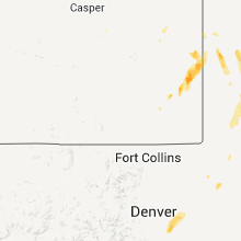
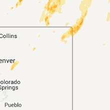
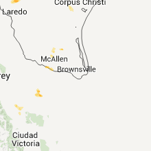
Hail Map for Friday, May 15, 2015

Number of Impacted Households on 5/15/2015
0
Impacted by 1" or Larger Hail
0
Impacted by 1.75" or Larger Hail
0
Impacted by 2.5" or Larger Hail
Square Miles of Populated Area Impacted on 5/15/2015
0
Impacted by 1" or Larger Hail
0
Impacted by 1.75" or Larger Hail
0
Impacted by 2.5" or Larger Hail


Cities Most Affected by Hail Storms of 5/15/2015
| Hail Size | Demographics of Zip Codes Affected | ||||||
|---|---|---|---|---|---|---|---|
| City | Count | Average | Largest | Pop Density | House Value | Income | Age |
| Sidney, NE | 2 | 1.88 | 2.00 | 18 | $61k | $34.3k | 38.2 |
| Ogallala, NE | 2 | 1.88 | 2.00 | 30 | $72k | $34.3k | 45.5 |
| Broadwater, NE | 2 | 1.75 | 1.75 | 1 | $23k | $26.8k | 47.6 |
| Bridgeport, NE | 2 | 1.75 | 1.75 | 2 | $50k | $30.3k | 42.9 |
| Alliance, NE | 1 | 2.75 | 2.75 | 10 | $73k | $39.4k | 40.8 |
| Mcdonald, NM | 1 | 2.00 | 2.00 | 1 | $36k | $12.9k | 60.0 |
| Grant, NE | 1 | 1.75 | 1.75 | 1 | $62k | $34.1k | 44.7 |
| Lakeside, NE | 1 | 1.75 | 1.75 | 0 | $33k | $30.8k | 39.9 |
| Lovington, NM | 1 | 1.75 | 1.75 | 18 | $49k | $28.5k | 31.1 |
Hail and Wind Damage Spotted on 5/15/2015
Filter by Report Type:Hail ReportsWind Reports
States Impacted
Texas, Louisiana, Missouri, Florida, Colorado, Illinois, Nebraska, Mississippi, Wyoming, Tennessee, Indiana, Kansas, Arkansas, New MexicoTexas
| Local Time | Report Details |
|---|---|
| 12:27 PM CDT | Barn roof blown onto highway 7 in nueces county TX, 28.5 miles WSW of Corpus Christi, TX |
| 12:28 PM CDT | Trained spotter at rest stop on i-37 near edroy estimated 60-65 mph wind gust in san patricio county TX, 18.7 miles WNW of Corpus Christi, TX |
| 1:00 PM CDT | Large tree limbs down near kostoryz road and saratoga blv in nueces county TX, 9.2 miles SE of Corpus Christi, TX |
| 1:00 PM CDT | Large tree limbs down near kostoryz road and saratoga blv in nueces county TX, 6.2 miles SSW of Corpus Christi, TX |
| 1:02 PM CDT | Media facebook page showed large tree limbs broken in front of kiii news statio in nueces county TX, 6.1 miles SSE of Corpus Christi, TX |
| 1:02 PM CDT | Media facebook page showed large tree limbs broken in front of kiii news statio in nueces county TX, 9.2 miles SE of Corpus Christi, TX |
| 1:17 PM CDT | Storm damage reported in san patricio county TX, 7.3 miles NE of Corpus Christi, TX |
| 1:25 PM CDT | Building blown down... trees and powerlines down near yorktown and rodd field. also street floodin in nueces county TX, 10.3 miles SSE of Corpus Christi, TX |
| 1:28 PM CDT | Storm damage reported in refugio county TX, 34.8 miles NNE of Corpus Christi, TX |
| 4:55 PM CDT | Willacy county emergency manager reported a telephone pole knocked down at 100 east sunset street in raymondvill in willacy county TX, 43.7 miles NNW of Brownsville, TX |
Louisiana
| Local Time | Report Details |
|---|---|
| 12:45 PM CDT | Tree limb snapped... fell on garage in tangipahoa county LA, 44.6 miles NNW of New Orleans, LA |
Missouri
| Local Time | Report Details |
|---|---|
| 1:06 PM CDT | Several tree limbs were snapped and a tree was uprooted. time is estimte in clay county MO, 7.8 miles NNE of Kansas City, MO |
| 2:35 PM CDT | *** 2 inj *** 2 recreational vehicles tipped over due to high winds at lakeside 370 rv park and campground. two minor injuries reported. no damage to surrounding struct in st. charles county MO, 24.5 miles WNW of Saint Louis, MO |
| 6:30 PM CDT | Tree limb down onto powerlin in polk county MO, 28.4 miles NNW of Springfield, MO |
| 7:30 PM CDT | Half Dollar sized hail reported near Versailles, MO, 45.2 miles SW of Columbia, MO, public photo of 1.25in hail shared on social media. |
Florida
| Local Time | Report Details |
|---|---|
| 1:20 PM CDT | 2 trees and a power line down just north of bonifay in holmes county FL, 50 miles NE of Miramar Beach, FL |
Colorado
| Local Time | Report Details |
|---|---|
| 12:52 PM MDT | Half Dollar sized hail reported near Aurora, CO, 15.3 miles SE of Denver, CO |
| 12:52 PM MDT | Half Dollar sized hail reported near Aurora, CO, 18.7 miles SE of Denver, CO |
| 1:00 PM MDT | Quarter sized hail reported near Aurora, CO, 15.3 miles SE of Denver, CO |
| 1:20 PM MDT | Half Dollar sized hail reported near Dacono, CO, 23.6 miles N of Denver, CO |
| 1:52 PM MDT | Quarter sized hail reported near Longmont, CO, 25.6 miles N of Denver, CO |
| 2:30 PM MDT | Quarter sized hail reported near La Salle, CO, 44.7 miles NNE of Denver, CO |
| 6:59 PM MDT | Quarter sized hail reported near Julesburg, CO, 64.9 miles NNE of Yuma, CO |
| 7:00 PM MDT | Half Dollar sized hail reported near Holyoke, CO, 44.2 miles NNE of Yuma, CO |
| 7:27 PM MDT | Ping Pong Ball sized hail reported near Julesburg, CO, 64.9 miles NNE of Yuma, CO |
Illinois
| Local Time | Report Details |
|---|---|
| 2:47 PM CDT | Tree down blocking route 100 west of pierre marquette sp in jersey county IL, 29.3 miles NW of Saint Louis, MO |
| 2:57 PM CDT | Tree down blocking route 16 in jersey county IL, 37.5 miles NNW of Saint Louis, MO |
| 3:00 PM CDT | Several trees down within the city in jersey county IL, 34.7 miles NNW of Saint Louis, MO |
| 3:45 PM CDT | Multiple power poles down east of village. from pawnee esd in sangamon county IL, 62.6 miles W of Mattoon, IL |
| 4:36 PM CDT | Tree limb fell on a power line. from gust fron in logan county IL, 39.1 miles SSE of Peoria, IL |
| 4:51 PM CDT | One tree blown down. relayed by wcia-t in piatt county IL, 32 miles NNW of Mattoon, IL |
| 4:54 PM CDT | Tree limbs down on mlk drive. time estimated. from wand-t in macon county IL, 39 miles NW of Mattoon, IL |
| 4:56 PM CDT | One power pole snapped. time estimated. relayed by medi in lawrence county IL, 51 miles N of Evansville, IN |
| 5:53 PM CDT | Numerous trees down and power outages. time estimate in crawford county IL, 52.8 miles SE of Mattoon, IL |
| 5:55 PM CDT | Two trees down on roads in danville in vermilion county IL, 60.7 miles NE of Mattoon, IL |
Nebraska
| Local Time | Report Details |
|---|---|
| 2:30 PM MDT | Golf Ball sized hail reported near Sidney, NE, 51.7 miles SSE of Scottsbluff, NE, ping-pong to golf-ball sized hail reported. |
| 2:38 PM MDT | Quarter sized hail reported near Gurley, NE, 45.9 miles SE of Scottsbluff, NE |
| 2:40 PM MDT | Half Dollar sized hail reported near Gurley, NE, 48.6 miles SE of Scottsbluff, NE |
| 3:35 PM MDT | Golf Ball sized hail reported near Bridgeport, NE, 32 miles ESE of Scottsbluff, NE, significant damage to vehicles. |
| 3:45 PM MDT | Half Dollar sized hail reported near Bridgeport, NE, 32 miles ESE of Scottsbluff, NE |
| 4:52 PM MDT | Quarter sized hail reported near Alliance, NE, 44 miles ENE of Scottsbluff, NE, dime to quarter size hail. |
| 5:01 PM MDT | Hen Egg sized hail reported near Sidney, NE, 56.8 miles SSE of Scottsbluff, NE, quarter to hen egg size hail. |
| 5:15 PM MDT | Quarter sized hail reported near Lisco, NE, 59.5 miles ESE of Scottsbluff, NE |
| 5:20 PM MDT | Baseball sized hail reported near Alliance, NE, 63.1 miles NE of Scottsbluff, NE, hail ranged from golf ball to baseball size |
| 5:25 PM MDT | Moved a pickic table 20 feet and destroyed i in morrill county NE, 32 miles ESE of Scottsbluff, NE |
| 5:32 PM MDT | Golf Ball sized hail reported near Bridgeport, NE, 28.2 miles ESE of Scottsbluff, NE |
| 5:42 PM MDT | Quarter sized hail reported near Broadwater, NE, 45.7 miles ESE of Scottsbluff, NE, marble to quarter size hail with very heavy rain. |
| 5:45 PM MDT | Golf Ball sized hail reported near Broadwater, NE, 45.7 miles ESE of Scottsbluff, NE, quarter to golfball size hail. |
| 6:15 PM MDT | Golf Ball sized hail reported near Lakeside, NE, 62.6 miles ENE of Scottsbluff, NE |
| 6:28 PM MDT | Golf Ball sized hail reported near Broadwater, NE, 39.7 miles ESE of Scottsbluff, NE, mostly pea to nickel size hail with largest golfball. |
| 7:30 PM MDT | Quarter sized hail reported near Venango, NE, 60.9 miles NE of Yuma, CO |
| 7:32 PM MDT | Quarter sized hail reported near Gordon, NE, 79.3 miles W of Valentine, NE |
| 8:48 PM CDT | Quarter sized hail reported near Arapahoe, NE, 70 miles SE of North Platte, NE, 5 miles north of arapahoe quarter size hail fell from 848 to 854 pm. |
| 7:55 PM MDT | Quarter sized hail reported near Lakeside, NE, 69.2 miles ENE of Scottsbluff, NE |
| 7:57 PM MDT | Wind speeds estimated at 50 to 60 mph in garden county NE, 76.2 miles WNW of North Platte, NE |
| 8:00 PM MDT | Quarter sized hail reported near Ellsworth, NE, 72 miles ENE of Scottsbluff, NE, estimated time of 900pm cdt |
| 8:00 PM MDT | Quarter sized hail reported near Lakeside, NE, 65 miles ENE of Scottsbluff, NE, estimated time of 900pm cdt |
| 8:15 PM MDT | Estimated 50 to 60 mph winds in sheridan county NE, 80.4 miles ENE of Scottsbluff, NE |
| 8:18 PM MDT | Quarter sized hail reported near Grant, NE, 58.9 miles WSW of North Platte, NE |
| 8:24 PM MDT | Golf Ball sized hail reported near Grant, NE, 52 miles WSW of North Platte, NE |
| 8:39 PM MDT | Estimated wind speeds of 60 to 70 mph in keith county NE, 49.9 miles W of North Platte, NE |
| 8:41 PM MDT | Golf Ball sized hail reported near Ogallala, NE, 49.4 miles W of North Platte, NE |
| 8:50 PM MDT | Hen Egg sized hail reported near Ogallala, NE, 48.1 miles W of North Platte, NE, 60 mph winds reported as well |
| 9:10 PM MDT | Quarter sized hail reported near Arthur, NE, 52 miles NW of North Platte, NE |
| 9:16 PM MDT | Ping Pong Ball sized hail reported near Ogallala, NE, 43.7 miles W of North Platte, NE |
Mississippi
| Local Time | Report Details |
|---|---|
| 3:40 PM CDT | A few trees were down. one tree was down on a house which was on fir in warren county MS, 40.4 miles W of Jackson, MS |
| 3:50 PM CDT | Trees were downed at calhoun ave and 11th st...along gordon ave...and along judkins r in yazoo county MS, 40.9 miles NNW of Jackson, MS |
| 4:25 PM CDT | Trees downed along old hwy 19 in se lauderdale co in lauderdale county MS, 73.2 miles WNW of Camden, AL |
Wyoming
| Local Time | Report Details |
|---|---|
| 3:48 PM MDT | Quarter sized hail reported near Torrington, WY, 27.3 miles WNW of Scottsbluff, NE, covering the ground. |
Tennessee
| Local Time | Report Details |
|---|---|
| 5:00 PM CDT | A few trees down on winding ridge road. trees blocking roa in mcnairy county TN, 50.2 miles NW of Florence, AL |
| 10:00 PM CDT | Trees down and power outages reported throughout the county. radar indicated winds were in the 40kt rang in hardin county TN, 43.2 miles NW of Florence, AL |
Indiana
| Local Time | Report Details |
|---|---|
| 7:20 PM EDT | 60 mph wind measured ay channel 2 locatio in sullivan county IN, 55.7 miles ESE of Mattoon, IL |
| 7:45 PM EDT | Small tree limbs down. location is us 41 and oregon church road in vigo county IN, 57.2 miles E of Mattoon, IL |
| 7:46 PM EDT | Storm damage reported in vigo county IN, 57 miles E of Mattoon, IL |
| 8:33 PM EDT | Power lines down at 226th street and state route 38 in hamilton county IN, 22.6 miles N of Indianapolis, IN |
Kansas
| Local Time | Report Details |
|---|---|
| 7:18 PM CDT | Quarter sized hail reported near Ellis, KS, 12.7 miles NNW of Hays, KS |
| 9:20 PM MDT | Carport blown over a building and onto main stree in sherman county KS, 35.8 miles W of Colby, KS |
| 9:21 PM MDT | Storm damage reported in sherman county KS, 35.8 miles W of Colby, KS |
Arkansas
| Local Time | Report Details |
|---|---|
| 8:40 PM CDT | Power lines were blown dow in monroe county AR, 66.3 miles WSW of Memphis, TN |
| 8:40 PM CDT | Power poles and power lines were blown down on highway 241 west of u.s. 4 in monroe county AR, 64.5 miles E of Little Rock, AR |
New Mexico
| Local Time | Report Details |
|---|---|
| 9:32 PM MDT | Golf Ball sized hail reported near Lovington, NM, 74.6 miles ESE of Roswell, NM |
| 9:42 PM MDT | Hen Egg sized hail reported near Mcdonald, NM, 71.8 miles ESE of Roswell, NM |
| 9:47 PM MDT | Quarter sized hail reported near Milnesand, NM, 78.1 miles ENE of Roswell, NM |
Connect with Interactive Hail Maps