

Hail Map for Saturday, May 16, 2015

Number of Impacted Households on 5/16/2015
0
Impacted by 1" or Larger Hail
0
Impacted by 1.75" or Larger Hail
0
Impacted by 2.5" or Larger Hail
Square Miles of Populated Area Impacted on 5/16/2015
0
Impacted by 1" or Larger Hail
0
Impacted by 1.75" or Larger Hail
0
Impacted by 2.5" or Larger Hail


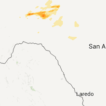


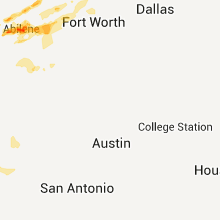


Cities Most Affected by Hail Storms of 5/16/2015
| Hail Size | Demographics of Zip Codes Affected | ||||||
|---|---|---|---|---|---|---|---|
| City | Count | Average | Largest | Pop Density | House Value | Income | Age |
| Quanah, TX | 8 | 2.25 | 2.75 | 5 | $30k | $28.1k | 43.6 |
| Abilene, TX | 2 | 2.50 | 3.00 | 75 | $58k | $26.3k | 30.2 |
| Iraan, TX | 2 | 1.75 | 1.75 | 0 | $42k | $46.3k | 37.4 |
| Ozona, TX | 2 | 1.75 | 1.75 | 0 | $52k | $29.9k | 39.5 |
| Castle, OK | 1 | 2.75 | 2.75 | 11 | $38k | $29.9k | 42.6 |
| Happy, TX | 1 | 2.50 | 2.50 | 1 | $37k | $32.6k | 41.3 |
| Quail, TX | 1 | 2.00 | 2.00 | 1 | $39k | $27.1k | 54.3 |
| Paducah, TX | 1 | 1.75 | 1.75 | 0 | $26k | $24.6k | 46.5 |
| Lelia Lake, TX | 1 | 1.75 | 1.75 | 11 | $30k | $30.5k | 47.3 |
| Custer, MT | 1 | 1.75 | 1.75 | 0 | $48k | $28.8k | 50.6 |
| Vinita, OK | 1 | 1.75 | 1.75 | 27 | $57k | $30.5k | 42.7 |
Hail and Wind Damage Spotted on 5/16/2015
Filter by Report Type:Hail ReportsWind Reports
States Impacted
Texas, Virginia, Pennsylvania, New Mexico, West Virginia, Mississippi, Florida, Oklahoma, Kansas, Minnesota, New Jersey, Arkansas, Maryland, Nebraska, North Dakota, Montana, Alabama, Missouri, Iowa, LouisianaTexas
| Local Time | Report Details |
|---|---|
| 12:30 PM CDT | Half Dollar sized hail reported near Kress, TX, 53.9 miles N of Lubbock, TX, estimated 1.25 hail in kress. 4 large home windows broken from wind driven hail. |
| 2:05 PM CDT | Quarter sized hail reported near Clarendon, TX, 48.8 miles NW of Childress, TX |
| 2:10 PM CDT | Half Dollar sized hail reported near Clarendon, TX, 52.3 miles NW of Childress, TX, pea size to half dollar size hail |
| 2:15 PM CDT | Quarter sized hail reported near Clarendon, TX, 48.8 miles NW of Childress, TX |
| 2:18 PM CDT | Ping Pong Ball sized hail reported near Clarendon, TX, 52.3 miles NW of Childress, TX |
| 2:31 PM CDT | Golf Ball sized hail reported near Lelia Lake, TX, 45.5 miles NW of Childress, TX |
| 2:46 PM CDT | Quarter sized hail reported near Stratford, TX, 76.3 miles N of Amarillo, TX |
| 2:56 PM CDT | Tennis Ball sized hail reported near Happy, TX, 33.6 miles SSE of Amarillo, TX |
| 3:00 PM CDT | Quarter sized hail reported near Turkey, TX, 39.5 miles W of Childress, TX |
| 3:08 PM CDT | Quarter sized hail reported near Claude, TX, 27.7 miles ESE of Amarillo, TX |
| 3:12 PM CDT | Ping Pong Ball sized hail reported near Claude, TX, 22.8 miles ESE of Amarillo, TX, quarter to ping pong ball size west of claude to claude |
| 3:24 PM CDT | Quarter sized hail reported near Panhandle, TX, 25.7 miles E of Amarillo, TX, quarter size hail in conway reported by fire department. |
| 3:30 PM CDT | Hen Egg sized hail reported near Quail, TX, 41.6 miles NNW of Childress, TX |
| 4:07 PM CDT | Golf Ball sized hail reported near Paducah, TX, 29.4 miles S of Childress, TX, mostly quarters with a few golf balls |
| 4:08 PM CDT | Storm damage reported in cottle county TX, 29.4 miles S of Childress, TX |
| 4:08 PM CDT | 4-6 tree limbs broken in cottle county TX, 29.4 miles S of Childress, TX |
| 4:31 PM CDT | Storm damage reported in foard county TX, 21.5 miles SE of Childress, TX |
| 4:31 PM CDT | Less than 2-inch small tree limbs downed in foard county TX, 21.5 miles SE of Childress, TX |
| 4:45 PM CDT | Golf Ball sized hail reported near Quanah, TX, 21.5 miles ESE of Childress, TX, reported by kolj radio |
| 4:45 PM CDT | Baseball sized hail reported near Quanah, TX, 21.5 miles ESE of Childress, TX |
| 4:54 PM CDT | Hen Egg sized hail reported near Quanah, TX, 28 miles ESE of Childress, TX |
| 4:57 PM CDT | Baseball sized hail reported near Quanah, TX, 28.4 miles ESE of Childress, TX |
| 4:58 PM CDT | Golf Ball sized hail reported near Quanah, TX, 28.4 miles ESE of Childress, TX, from kolj radio |
| 5:00 PM CDT | Tennis Ball sized hail reported near Quanah, TX, 29.4 miles ESE of Childress, TX |
| 5:00 PM CDT | Storm damage reported in hardeman county TX, 29.4 miles ESE of Childress, TX |
| 5:05 PM CDT | Golf Ball sized hail reported near Quanah, TX, 29.4 miles ESE of Childress, TX |
| 5:09 PM CDT | Baseball sized hail reported near Quanah, TX, 32 miles ESE of Childress, TX |
| 5:25 PM CDT | Storm damage reported in foard county TX, 41.8 miles SE of Childress, TX |
| 5:35 PM CDT | Storm damage reported in nolan county TX, 46.6 miles W of Abilene, TX |
| 6:15 PM CDT | Quarter sized hail reported near Knox City, TX, 67.1 miles N of Abilene, TX |
| 6:15 PM CDT | Camper blown over in knox county TX, 67.1 miles N of Abilene, TX |
| 6:30 PM CDT | Quarter sized hail reported near Merkel, TX, 16.9 miles WNW of Abilene, TX |
| 6:35 PM CDT | Half Dollar sized hail reported near Merkel, TX, 13.5 miles WNW of Abilene, TX |
| 7:00 PM CDT | Tree limbs down in jones county TX, 11.5 miles NNE of Abilene, TX |
| 7:10 PM CDT | Half Dollar sized hail reported near Hawley, TX, 11.8 miles NNW of Abilene, TX |
| 7:15 PM CDT | Ping Pong Ball sized hail reported near Hawley, TX, 11.8 miles NNW of Abilene, TX |
| 7:25 PM CDT | Ping Pong Ball sized hail reported near Abilene, TX, 9.6 miles NNE of Abilene, TX |
| 7:25 PM CDT | Quarter sized hail reported near Abilene, TX, 9.1 miles NNE of Abilene, TX, east side of lake fort phantom hill |
| 7:30 PM CDT | Ping Pong Ball sized hail reported near Abilene, TX, 10.8 miles NE of Abilene, TX |
| 7:30 PM CDT | Tea Cup sized hail reported near Abilene, TX, 8.4 miles NNE of Abilene, TX, south end of lake fort phantom hill |
| 7:42 PM CDT | Storm damage reported in throckmorton county TX, 60 miles NNE of Abilene, TX |
| 8:10 PM CDT | Ping Pong Ball sized hail reported near Iraan, TX, 70.5 miles SSE of Odessa, TX |
| 8:13 PM CDT | Golf Ball sized hail reported near Iraan, TX, 70.5 miles SSE of Odessa, TX, sheriffs office reports golf ball sized hail falling in iraan. |
| 8:18 PM CDT | Golf Ball sized hail reported near Iraan, TX, 72.4 miles SSE of Odessa, TX |
| 8:24 PM CDT | Ping Pong Ball sized hail reported near Abilene, TX, 2.8 miles NE of Abilene, TX, interstate 20 and campus court |
| 8:25 PM CDT | Quarter sized hail reported near Abilene, TX, 2.8 miles NE of Abilene, TX |
| 8:38 PM CDT | Hen Egg sized hail reported near Abilene, TX, 12.1 miles NNE of Abilene, TX |
| 9:02 PM CDT | Storm damage reported in shackelford county TX, 32.2 miles NE of Abilene, TX |
| 9:05 PM CDT | Quarter sized hail reported near Abilene, TX, 3.8 miles SSW of Abilene, TX, quarter size hail at john knox and ridgemont |
| 9:19 PM CDT | Storm damage reported in irion county TX, 98 miles ESE of Odessa, TX |
| 10:22 PM CDT | Golf Ball sized hail reported near Ozona, TX, 95.9 miles SE of Odessa, TX |
| 11:12 PM CDT | Golf Ball sized hail reported near Ozona, TX, 97.6 miles NNW of Del Rio, TX |
| 11:25 PM CDT | Storm damage reported in crockett county TX, 93.4 miles N of Del Rio, TX |
| 11:40 PM CDT | Powerlines down around mineral wells in palo pinto county TX, 76 miles W of Dallas, TX |
| 11:40 PM CDT | Roof damage to a house on fm1195 off hwy 281 in palo pinto county TX, 74.8 miles W of Dallas, TX |
| 11:42 PM CDT | Part of the roof of a frame house removed. trailer home pushed off pinnings abt 2 ft. metal poles ripped outof groun in parker county TX, 74.8 miles W of Dallas, TX |
| 11:51 PM CDT | Roof damage to a house on fm1195 off 281 in palo pinto county TX, 74.8 miles W of Dallas, TX |
| 11:55 PM CDT | Large trees down across old authon road just west of hwy 1885 in parker county TX, 62 miles W of Dallas, TX |
| 12:05 AM CDT | 2-car garage destroyed near hwy 51 and carter road in parker county TX, 52.3 miles W of Dallas, TX |
| 1:17 AM CDT | Roof and siding damage to homes. large limbs down. power lines downe in grayson county TX, 50.1 miles SSW of Atoka, OK |
Virginia
| Local Time | Report Details |
|---|---|
| 3:29 PM EDT | Half Dollar sized hail reported near Stanardsville, VA, 71.4 miles NW of Richmond, VA |
| 3:35 PM EDT | A tree was reported down on lucas lan in frederick county VA, 85.4 miles ENE of Elkins, WV |
| 3:48 PM EDT | A tree was reported down on glengary roa in frederick county VA, 85.9 miles W of Baltimore, MD |
| 3:57 PM EDT | Several trees and large tree limbs down on route 7 near morgan mill roa in frederick county VA, 80.8 miles W of Baltimore, MD |
| 4:06 PM EDT | A tree snapped alongside a soccer field on kerfoot avenu in warren county VA, 88.1 miles E of Elkins, WV |
| 4:54 PM EDT | A tree was reported down on powerlines on whites ferry road near james monroe highwa in loudoun county VA, 50.9 miles W of Baltimore, MD |
Pennsylvania
| Local Time | Report Details |
|---|---|
| 3:52 PM EDT | Wires down on a hous in cumberland county PA, 54.4 miles SSE of State College, PA |
| 4:00 PM EDT | Quarter sized hail reported near Scranton, PA, 4.4 miles NNE of Scranton, PA |
| 4:00 PM EDT | Tree down in throop in lackawanna county PA, 4.4 miles NNE of Scranton, PA |
| 4:24 PM EDT | Large limbs down and the top of a chimney knocked dow in perry county PA, 47 miles ESE of State College, PA |
| 6:47 PM EDT | Quarter sized hail reported near Gilbertsville, PA, 75.3 miles S of Scranton, PA |
| 6:48 PM EDT | Tree down in douglass township in montgomery county PA, 73.3 miles S of Scranton, PA |
| 6:48 PM EDT | Tree down in new hanover township in montgomery county PA, 76.1 miles S of Scranton, PA |
New Mexico
| Local Time | Report Details |
|---|---|
| 2:00 PM MDT | Storm damage reported in curry county NM, 36.2 miles SE of Tucumcari, NM |
West Virginia
| Local Time | Report Details |
|---|---|
| 4:11 PM EDT | Large tree limbs were reported down on route 9 near wiltshire roa in jefferson county WV, 67.7 miles W of Baltimore, MD |
| 4:20 PM EDT | Large tree limbs were reported down on highway 340 at chestnut hill roa in jefferson county WV, 60.1 miles W of Baltimore, MD |
Mississippi
| Local Time | Report Details |
|---|---|
| 3:30 PM CDT | Three trees and some limbs were down. one tree was down on a mobile hom in scott county MS, 33.2 miles NE of Jackson, MS |
| 4:40 PM CDT | A few trees were down in holly ridg in sunflower county MS, 81.9 miles NE of Bastrop, LA |
| 5:20 PM CDT | Quarter sized hail reported near Glen Allan, MS, 55.2 miles ENE of Bastrop, LA |
Florida
| Local Time | Report Details |
|---|---|
| 3:45 PM CDT | Tree down on spears road as well as limbs down on the road near highway 2 and highway 177 in holmes county FL, 54.2 miles NE of Miramar Beach, FL |
Oklahoma
| Local Time | Report Details |
|---|---|
| 3:45 PM CDT | Quarter sized hail reported near Texhoma, OK, 87.8 miles N of Amarillo, TX |
| 3:51 PM CDT | Storm damage reported in roger mills county OK, 71.1 miles NNE of Childress, TX |
| 4:45 PM CDT | Quarter sized hail reported near Cheyenne, OK, 53.8 miles SSW of Woodward, OK |
| 5:22 PM CDT | Storm damage reported in jackson county OK, 39.9 miles ENE of Childress, TX |
| 5:30 PM CDT | Mobile home blown over... others damage in dewey county OK, 39 miles S of Woodward, OK |
| 5:35 PM CDT | Shed destroyed in jackson county OK, 45.2 miles E of Childress, TX |
| 6:20 PM CDT | Trees down in major county OK, 53.5 miles E of Woodward, OK |
| 6:33 PM CDT | Power lines downed east of red river bridge on hwy 5 in tillman county OK, 54.8 miles NW of Wichita Falls, TX |
| 7:00 PM CDT | Car was flipped over. roof from office bldg was damage in major county OK, 53.5 miles E of Woodward, OK |
| 7:20 PM CDT | Storm damage reported in comanche county OK, 56.7 miles N of Wichita Falls, TX |
| 7:46 PM CDT | On hwy 62 in comanche county OK, 63.4 miles N of Wichita Falls, TX |
| 8:08 PM CDT | Storm damage reported in comanche county OK, 50.6 miles N of Wichita Falls, TX |
| 8:11 PM CDT | Trees down... not very large. reported by kswo in comanche county OK, 43.8 miles N of Wichita Falls, TX |
| 9:20 PM CDT | Storm damage reported in oklahoma county OK, 8.2 miles ESE of Oklahoma City, OK |
| 9:42 PM CDT | 30-inch tree downed and blocking old hwy 81 in stephens county OK, 44.5 miles NE of Wichita Falls, TX |
| 9:50 PM CDT | 2.5-inch tree downed and blocking a stree in stephens county OK, 51.2 miles NE of Wichita Falls, TX |
| 10:02 PM CDT | Baseball sized hail reported near Castle, OK, 51.6 miles SSW of Tulsa, OK, relayed by kotv |
| 10:30 PM CDT | Storm damage reported in osage county OK, 15.2 miles N of Tulsa, OK |
| 10:30 PM CDT | Damage to a gazebo. time estimated by rada in osage county OK, 12.5 miles NW of Tulsa, OK |
| 10:39 PM CDT | Storm damage reported in osage county OK, 18.2 miles N of Tulsa, OK |
| 10:45 PM CDT | Storm damage reported in washington county OK, 52.7 miles N of Tulsa, OK |
| 10:45 PM CDT | Time estimated by rada in washington county OK, 21.6 miles NNE of Tulsa, OK |
| 11:00 PM CDT | Storm damage reported in okmulgee county OK, 22.1 miles S of Tulsa, OK |
| 11:30 PM CDT | Tree and home damage. power poles snapped. roof and home damage. possible tornado. time estimated by rada in wagoner county OK, 18.4 miles ESE of Tulsa, OK |
| 11:33 PM CDT | Measured at tulsa international airport in tulsa county OK, 4.3 miles ESE of Tulsa, OK |
| 11:46 PM CDT | Reported near 106th street north and highway 16 in tulsa county OK, 11.5 miles NE of Tulsa, OK |
| 11:48 PM CDT | Measured on highway 41 in rogers county OK, 29.3 miles E of Tulsa, OK |
| 11:48 PM CDT | Damage to homes near the kinx radar site from possible tornad in rogers county OK, 24.4 miles E of Tulsa, OK |
| 12:18 AM CDT | Storm damage reported in mcintosh county OK, 63.7 miles SSE of Tulsa, OK |
| 12:36 AM CDT | Golf Ball sized hail reported near Vinita, OK, 59.5 miles NE of Tulsa, OK |
| 12:40 AM CDT | Power lines down and homes damaged near 590 and 220 road from probable tornad in ottawa county OK, 75.6 miles ENE of Tulsa, OK |
| 12:50 AM CDT | Report via twitter in cherokee county OK, 51.9 miles NW of Fort Smith, AR |
| 12:52 AM CDT | Storm damage reported in delaware county OK, 68.6 miles ENE of Tulsa, OK |
Kansas
| Local Time | Report Details |
|---|---|
| 4:00 PM CDT | Storm damage reported in grant county KS, 35.5 miles SW of Garden City, KS |
| 4:04 PM CDT | Large tree limbs down at the 4 h building in ulysses in grant county KS, 37.3 miles SW of Garden City, KS |
| 4:05 PM CDT | Quarter sized hail reported near Ulysses, KS, 35.9 miles SW of Garden City, KS |
| 4:42 PM CDT | Storm damage reported in finney county KS, 0.7 miles SSW of Garden City, KS |
| 4:45 PM CDT | Quarter sized hail reported near Holcomb, KS, 6.4 miles W of Garden City, KS |
| 4:47 PM CDT | Quarter sized hail reported near Holcomb, KS, 6.9 miles WSW of Garden City, KS |
| 4:50 PM CDT | Electrical line down due to strong wind in finney county KS, 1.5 miles W of Garden City, KS |
| 5:08 PM CDT | Storm damage reported in greenwood county KS, 46.9 miles WNW of Chanute, KS |
| 5:10 PM CDT | Storm damage reported in chase county KS, 56.6 miles NE of Wichita, KS |
| 5:10 PM CDT | Delayed report...westar energy reports a roof off of a house near eureka city lake in greenwood county KS, 47.9 miles WNW of Chanute, KS |
| 5:25 PM CDT | Delayed report of small tree limbs down in madiso in greenwood county KS, 48.7 miles NW of Chanute, KS |
| 5:27 PM CDT | A roof was blown off a barn due to staight line wind in greenwood county KS, 46.2 miles NW of Chanute, KS |
| 5:30 PM CDT | Storm damage reported in lyon county KS, 56.3 miles SSE of Manhattan, KS |
| 5:31 PM CDT | Barns and homes damaged in lyon county KS, 55.4 miles NW of Chanute, KS |
| 5:36 PM CDT | Several large trees down including a 100 year old healthy elm tree snapped at the base of the tree trunk. damage possibly the result of a tornad in lyon county KS, 55.2 miles NNW of Chanute, KS |
| 5:38 PM CDT | Train was stopped and blown over by win in lyon county KS, 57.2 miles NNW of Chanute, KS |
| 6:04 PM CDT | Storm damage reported in osage county KS, 54.7 miles SE of Manhattan, KS |
| 6:30 PM CDT | Delayed report. roof blown off of a barn on s. paulen rd in overbroo in osage county KS, 59.6 miles ESE of Manhattan, KS |
| 6:30 PM CDT | 60mph winds reported by spotter. this was right along hwy 75 6 miles south of topek in shawnee county KS, 49.8 miles ESE of Manhattan, KS |
| 11:34 PM CDT | Em relayed reports of multiple power lines and trees down near the junction of ks hwy 7 and ks hwy 152 west of lacygne. possible damage to a barn in the area also repor in linn county KS, 53.9 miles NNE of Chanute, KS |
| 12:23 AM CDT | Storm damage reported in cherokee county KS, 43.2 miles SE of Chanute, KS |
Minnesota
| Local Time | Report Details |
|---|---|
| 4:38 PM CDT | Measured with big stone raws. time estimated based on rada in big stone county MN, 37.2 miles NW of Montevideo, MN |
| 7:58 PM CDT | Quarter sized hail reported near Litchfield, MN, 59.6 miles W of Minneapolis, MN, nickel to quarter sized hail reported in the greenleaf area. |
| 9:25 PM CDT | Law enforcement reported a tree on a house 2 miles s of waverly. power line also dow in wright county MN, 34.8 miles W of Minneapolis, MN |
New Jersey
| Local Time | Report Details |
|---|---|
| 5:48 PM EDT | Wires down in stillwater townshi in sussex county NJ, 46.5 miles ESE of Scranton, PA |
Arkansas
| Local Time | Report Details |
|---|---|
| 4:55 PM CDT | 2 trees down on highway 82e just outside of magnolia in columbia county AR, 58.4 miles SE of Nashville, AR |
| 1:00 AM CDT | Tree fell on a house near beaty and leonard ranch road in benton county AR, 73 miles N of Fort Smith, AR |
Maryland
| Local Time | Report Details |
|---|---|
| 6:54 PM EDT | Wires down on st james/new town road in worton in kent county MD, 27.9 miles E of Baltimore, MD |
Nebraska
| Local Time | Report Details |
|---|---|
| 6:45 PM CDT | Quarter sized hail reported near Maywood, NE, 39.6 miles SSE of North Platte, NE |
| 8:08 PM CDT | Storm damage reported in harlan county NE, 70.6 miles SW of Grand Island, NE |
North Dakota
| Local Time | Report Details |
|---|---|
| 7:11 PM CDT | Storm damage reported in stutsman county ND, 81.4 miles S of Devils Lake, ND |
| 6:58 PM MDT | Quarter sized hail reported near Sentinel Butte, ND, 91 miles S of Williston, ND, 1inch hail and heavy rain |
| 7:13 PM MDT | Quarter sized hail reported near Sentinel Butte, ND, 91 miles S of Williston, ND, 1inch hail and heavy rain |
Montana
| Local Time | Report Details |
|---|---|
| 6:30 PM MDT | Golf Ball sized hail reported near Custer, MT, 46.2 miles ENE of Billings, MT |
| 7:31 PM MDT | Half Dollar sized hail reported near Hardin, MT, 43.3 miles E of Billings, MT |
Alabama
| Local Time | Report Details |
|---|---|
| 8:43 PM CDT | A tree was knocked onto power lines on cr 695. time estimated by rada in dekalb county AL, 47 miles SW of Chattanooga, TN |
| 8:46 PM CDT | A tree was knocked down on carlyle road. time estimated by rada in dekalb county AL, 46.8 miles SW of Chattanooga, TN |
Missouri
| Local Time | Report Details |
|---|---|
| 9:42 PM CDT | Fire department reported power poles down and possible building collaps in ray county MO, 31 miles NE of Kansas City, MO |
| 9:42 PM CDT | Trees and limbs down. time estimated from radar at 942 pm in ray county MO, 31 miles NE of Kansas City, MO |
| 12:07 AM CDT | Outdoor shed destroye in bates county MO, 50.1 miles SSE of Kansas City, MO |
| 12:15 AM CDT | Severe thunderstorm wind gusts blew down a tree in nevad in vernon county MO, 61.3 miles E of Chanute, KS |
| 12:34 AM CDT | Estimated 70 mph winds with 6-8 inch diameter branches cracking off of trees in caldwell county MO, 53.3 miles NE of Kansas City, MO |
| 12:41 AM CDT | Barns heavily damaged just west of 220th and 13 hwy in caldwell county MO, 42.4 miles NE of Kansas City, MO |
| 12:44 AM CDT | Em relayed public report of estimated winds exceeding 60 mph with power flickering in daviess county MO, 73 miles NE of Kansas City, MO |
| 12:50 AM CDT | Tree limbs down in daviess county MO, 79.9 miles NNE of Kansas City, MO |
| 12:55 AM CDT | Severe thunderstorm wind gusts damaged trees and power line in newton county MO, 74.3 miles SE of Chanute, KS |
| 1:00 AM CDT | Fire chief estimated tstorm wind gusts 50 to 60 mp in mcdonald county MO, 78.7 miles WSW of Springfield, MO |
| 1:05 AM CDT | Storm damage reported in mcdonald county MO, 69.3 miles WSW of Springfield, MO |
| 1:06 AM CDT | Several homes damaged on 14000 block of heron drive. damage to roofs... windows blown out of homes... trees down and detached garages heavily damage in newton county MO, 66.1 miles WSW of Springfield, MO |
| 1:11 AM CDT | Measure at business 49 and south street in newton county MO, 65.3 miles WSW of Springfield, MO |
| 1:20 AM CDT | Em relayed report of estimated 60 mph winds with pea size hail in pettis county MO, 59.9 miles WSW of Columbia, MO |
| 1:20 AM CDT | Tree down on the eastbound lane of highway 6 near highway cc... making it impassible in daviess county MO, 63.9 miles NNE of Kansas City, MO |
| 1:29 AM CDT | Powerlines down east of sarcoxi in jasper county MO, 46.7 miles WSW of Springfield, MO |
| 1:35 AM CDT | Trees blown down in monet in barry county MO, 40.5 miles WSW of Springfield, MO |
| 1:37 AM CDT | Em relayed report of 50 to 60 mph gust on highway 50 with sustained winds around 25 mph in pettis county MO, 57 miles WSW of Columbia, MO |
| 1:45 AM CDT | Amateur radio reports 60mph plus winds on north side of mt verno in lawrence county MO, 30.1 miles WSW of Springfield, MO |
| 1:51 AM CDT | Several limbs from mature trees down over the roadway in henry county MO, 66.6 miles SE of Kansas City, MO |
| 2:04 AM CDT | Trees down. one powerline reported dow in greene county MO, 13.2 miles WSW of Springfield, MO |
| 2:10 AM CDT | Spotter estimated 70-80mph wind gust near boliva in polk county MO, 27.4 miles NNW of Springfield, MO |
| 2:16 AM CDT | Trees down on highway o north of boliva in polk county MO, 39.5 miles NNW of Springfield, MO |
| 2:17 AM CDT | Trees down in willard at hwy ab/112 as well as hwy101/106. trees reported to be at least 3 ft in diamete in greene county MO, 10.3 miles NW of Springfield, MO |
| 2:30 AM CDT | Tree downed across a road. relayed report from publi in polk county MO, 35.9 miles N of Springfield, MO |
| 3:18 AM CDT | Storm damage reported in camden county MO, 63 miles NNE of Springfield, MO |
Iowa
| Local Time | Report Details |
|---|---|
| 2:05 AM CDT | Trees and grain bins down in clarke county IA, 36.6 miles SSW of Des Moines, IA |
| 2:35 AM CDT | Tree damage reported in madison county IA, 23 miles SSW of Des Moines, IA |
| 3:28 AM CDT | Multiple large trees over 12 inches in diameter down throughout town. time estimated from radar. via social medi in dallas county IA, 27.2 miles NW of Des Moines, IA |
Louisiana
| Local Time | Report Details |
|---|---|
| 4:10 AM CDT | Several trees uprooted west of natalbany. a tree blown down onto a vehicle in the stafford road area. time estimated by rada in tangipahoa county LA, 49.4 miles NNW of New Orleans, LA |
Connect with Interactive Hail Maps