

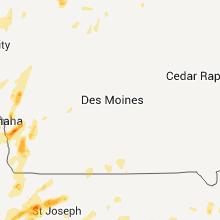
Hail Map for Saturday, May 21, 2011

Number of Impacted Households on 5/21/2011
0
Impacted by 1" or Larger Hail
0
Impacted by 1.75" or Larger Hail
0
Impacted by 2.5" or Larger Hail
Square Miles of Populated Area Impacted on 5/21/2011
0
Impacted by 1" or Larger Hail
0
Impacted by 1.75" or Larger Hail
0
Impacted by 2.5" or Larger Hail


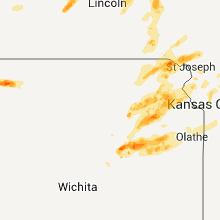
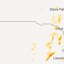


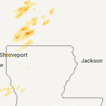
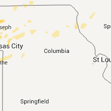


Cities Most Affected by Hail Storms of 5/21/2011
| Hail Size | Demographics of Zip Codes Affected | ||||||
|---|---|---|---|---|---|---|---|
| City | Count | Average | Largest | Pop Density | House Value | Income | Age |
| Topeka, KS | 11 | 2.41 | 5.00 | 1016 | $80k | $43.4k | 38.4 |
| Burnet, TX | 6 | 2.96 | 4.50 | 45 | $80k | $37.9k | 43.1 |
| Copperas Cove, TX | 4 | 2.13 | 3.00 | 336 | $74k | $39.0k | 29.8 |
| Mc Louth, KS | 3 | 2.42 | 2.75 | 31 | $87k | $47.4k | 41.5 |
| York, NE | 2 | 3.00 | 3.00 | 51 | $79k | $36.8k | 39.9 |
| Nortonville, KS | 3 | 1.75 | 1.75 | 12 | $58k | $40.6k | 41.6 |
| Meriden, KS | 3 | 1.75 | 1.75 | 45 | $86k | $47.9k | 43.1 |
| Easton, KS | 3 | 1.75 | 1.75 | 22 | $89k | $49.3k | 44.8 |
| Wallingford, IA | 2 | 2.25 | 2.75 | 11 | $62k | $39.3k | 34.2 |
| Eskridge, KS | 2 | 2.25 | 2.75 | 4 | $49k | $39.9k | 44.7 |
| Hamilton, TX | 2 | 2.25 | 2.75 | 12 | $45k | $31.2k | 47.6 |
| Oskaloosa, KS | 2 | 2.00 | 2.00 | 28 | $75k | $41.3k | 44.3 |
| Mayetta, KS | 2 | 1.88 | 2.00 | 19 | $67k | $44.8k | 40.0 |
| Saint Marys, KS | 2 | 1.75 | 1.75 | 62 | $80k | $40.2k | 24.7 |
| Hoyt, KS | 2 | 1.75 | 1.75 | 37 | $90k | $47.4k | 40.3 |
| Emporia, KS | 2 | 1.75 | 1.75 | 99 | $71k | $32.1k | 30.7 |
| Bertram, TX | 1 | 2.75 | 2.75 | 26 | $71k | $42.9k | 39.7 |
| Stephenville, TX | 1 | 2.75 | 2.75 | 61 | $72k | $30.6k | 29.6 |
| Osage City, KS | 1 | 2.75 | 2.75 | 27 | $72k | $35.6k | 42.1 |
| Highland, KS | 1 | 2.75 | 2.75 | 11 | $50k | $30.3k | 27.3 |
| Fort Hood, TX | 1 | 2.50 | 2.50 | 804 | $74k | $32.4k | 21.9 |
| Mound, MN | 1 | 2.00 | 2.00 | 961 | $171k | $66.7k | 43.1 |
| Allen, OK | 1 | 2.00 | 2.00 | 11 | $38k | $26.0k | 41.3 |
| Robinson, KS | 1 | 1.75 | 1.75 | 6 | $43k | $26.2k | 43.6 |
| Omaha, NE | 1 | 1.75 | 1.75 | 5214 | $130k | $36.8k | 30.7 |
| Newcastle, NE | 1 | 1.75 | 1.75 | 3 | $38k | $29.1k | 42.7 |
| Alma, KS | 1 | 1.75 | 1.75 | 6 | $69k | $42.6k | 46.5 |
| Hico, TX | 1 | 1.75 | 1.75 | 10 | $51k | $31.3k | 43.4 |
| Gatesville, TX | 1 | 1.75 | 1.75 | 32 | $59k | $34.7k | 38.7 |
| Timber, OR | 1 | 1.75 | 1.75 | 13 | $169k | $38.5k | 35.4 |
| Fairview, KS | 1 | 1.75 | 1.75 | 6 | $35k | $34.6k | 50.0 |
| Maskell, NE | 1 | 1.75 | 1.75 | 400 | $0k | $0.0k | 40.5 |
| Granbury, TX | 1 | 1.75 | 1.75 | 224 | $89k | $38.0k | 44.5 |
| Baldwin City, KS | 1 | 1.75 | 1.75 | 55 | $116k | $51.8k | 36.9 |
| Logan, IA | 1 | 1.75 | 1.75 | 25 | $84k | $40.6k | 40.2 |
| Surprise, NE | 1 | 1.75 | 1.75 | 7 | $48k | $39.2k | 44.3 |
| Kempner, TX | 1 | 1.75 | 1.75 | 59 | $95k | $47.3k | 40.8 |
| Murdock, NE | 1 | 1.75 | 1.75 | 12 | $87k | $42.5k | 44.2 |
| Portis, KS | 1 | 1.75 | 1.75 | 1 | $17k | $29.2k | 48.8 |
| Sulphur, OK | 1 | 1.75 | 1.75 | 43 | $53k | $30.6k | 41.9 |
| Easton, MO | 1 | 1.75 | 1.75 | 20 | $104k | $43.0k | 47.7 |
| Tecumseh, KS | 1 | 1.75 | 1.75 | 104 | $105k | $59.2k | 47.0 |
| Rosendale, MO | 1 | 1.75 | 1.75 | 19 | $46k | $34.3k | 36.9 |
| Bellevue, NE | 1 | 1.75 | 1.75 | 1325 | $98k | $44.5k | 35.9 |
| Wayne, NE | 1 | 1.75 | 1.75 | 38 | $82k | $30.2k | 24.0 |
Hail and Wind Damage Spotted on 5/21/2011
Filter by Report Type:Hail ReportsWind Reports
States Impacted
Texas, New York, Minnesota, Tennessee, Nebraska, Kansas, Arkansas, South Dakota, Kentucky, Iowa, Oklahoma, Missouri, North Dakota, VirginiaTexas
| Local Time | Report Details |
|---|---|
| 8:08 PM UTC | Golf Ball sized hail reported near Hamilton, TX, 46.4 miles NNW of Killeen, TX, us 281 and 2905 on the north side of hamilton |
| 8:38 PM UTC | Baseball sized hail reported near Stephenville, TX, 77.9 miles NNW of Killeen, TX |
| 8:42 PM UTC | Quarter sized hail reported near Hamilton, TX, 45.7 miles NW of Killeen, TX |
| 8:45 PM UTC | Ping Pong Ball sized hail reported near Stephenville, TX, 77.9 miles NNW of Killeen, TX |
| 8:45 PM UTC | Golf Ball sized hail reported near Hico, TX, 67 miles NNW of Killeen, TX |
| 9:08 PM UTC | Golf Ball sized hail reported near Granbury, TX, 62.8 miles WSW of Dallas, TX, quarter to golf ball hail in granbury |
| 9:10 PM UTC | Damage to roofs in evant...possible tornado time estimated in hamilton county TX, 34.9 miles NW of Killeen, TX |
| 10:50 PM UTC | Grapefruit sized hail reported near , , 16.7 miles WNW of Killeen, TX, fell near fm 1113 and cr 3295 inside the lampasas county line |
| 10:59 PM UTC | Baseball sized hail reported near Hamilton, TX, 49.4 miles NNW of Killeen, TX, on highway 36 |
| 11:02 PM UTC | Golf Ball sized hail reported near Copperas Cove, TX, 12.8 miles W of Killeen, TX |
| 11:05 PM UTC | Hen Egg sized hail reported near Copperas Cove, TX, 16.6 miles WNW of Killeen, TX |
| 11:06 PM UTC | Quarter sized hail reported near Copperas Cove, TX, 12.5 miles WNW of Killeen, TX, antelope crossing |
| 11:06 PM UTC | Tea Cup sized hail reported near Copperas Cove, TX, 16.6 miles WNW of Killeen, TX |
| 11:11 PM UTC | Golf Ball sized hail reported near Copperas Cove, TX, 12 miles WNW of Killeen, TX |
| 11:12 PM UTC | Quarter sized hail reported near Burnet, TX, 44.8 miles WSW of Killeen, TX |
| 11:18 PM UTC | Quarter sized hail reported near Copperas Cove, TX, 12.8 miles WNW of Killeen, TX |
| 11:23 PM UTC | Ping Pong Ball sized hail reported near Copperas Cove, TX, 11.5 miles W of Killeen, TX |
| 11:48 PM UTC | Baseball sized hail reported near Bertram, TX, 21 miles SW of Killeen, TX |
| 11:49 PM UTC | Ping Pong Ball sized hail reported near Burnet, TX, 35.1 miles SW of Killeen, TX |
| 11:55 PM UTC | Tennis Ball sized hail reported near Killeen, TX, 8.6 miles NW of Killeen, TX |
| 12:11 AM UTC | Quarter sized hail reported near Bertram, TX, 32.6 miles SW of Killeen, TX |
| 12:51 AM UTC | Golf Ball sized hail reported near Gatesville, TX, 21.6 miles N of Killeen, TX |
| 1:30 AM UTC | Ping Pong Ball sized hail reported near Burnet, TX, 39.5 miles WSW of Killeen, TX |
| 1:36 AM UTC | Grapefruit sized hail reported near Burnet, TX, 38.7 miles SW of Killeen, TX, grapefruit size hail falling in north central burnet. |
| 1:40 AM UTC | Softball sized hail reported near Burnet, TX, 38.7 miles SW of Killeen, TX, 5 inch hail measured. |
| 1:42 AM UTC | Baseball sized hail reported near Burnet, TX, 37.4 miles SW of Killeen, TX, golfball to baseball size hail near burnet. |
| 1:48 AM UTC | Baseball sized hail reported near Burnet, TX, 38.7 miles SW of Killeen, TX |
| 1:53 AM UTC | Hen Egg sized hail reported near Burnet, TX, 38.7 miles SW of Killeen, TX, measured hail with 2.38 inches across. |
| 1:57 AM UTC | Minor mobile home damage in and around andice as well as some fences blown dow in williamson county TX, 24.3 miles SSW of Killeen, TX |
| 1:59 AM UTC | Golf Ball sized hail reported near Burnet, TX, 38.7 miles SW of Killeen, TX |
| 2:24 AM UTC | Quarter sized hail reported near Bertram, TX, 31.5 miles SW of Killeen, TX |
| 3:55 AM UTC | Quarter sized hail reported near Lampasas, TX, 22.7 miles W of Killeen, TX, 5 miles north of radio junction |
| 5:17 AM UTC | Golf Ball sized hail reported near Kempner, TX, 20.9 miles W of Killeen, TX |
New York
| Local Time | Report Details |
|---|---|
| 8:38 PM UTC | Tree limbs down. nickel size hail covered the ground. hail lasted about 10 minutes. hail is still on the ground as of 7 pm. lots of leaves down on the groun in oneida county NY, 30.4 miles NE of Syracuse, NY |
| 8:38 PM UTC | Limbs down. also nickel size hail. house located on walker roa in oneida county NY, 30 miles NE of Syracuse, NY |
Minnesota
| Local Time | Report Details |
|---|---|
| 9:17 PM UTC | Quarter sized hail reported near Cokato, MN, 45.8 miles W of Minneapolis, MN |
| 4:44 PM CDT | Ping Pong Ball sized hail reported near Howard Lake, MN, 43.4 miles W of Minneapolis, MN |
| 6:00 PM CDT | Hen Egg sized hail reported near Mound, MN, 19.6 miles W of Minneapolis, MN |
| 6:08 PM CDT | Quarter sized hail reported near Minnetrista, MN, 22.1 miles W of Minneapolis, MN, varied pea to one inch |
| 11:10 PM UTC | Quarter sized hail reported near Wheaton, MN, 70.5 miles NNW of Montevideo, MN, mostly pea size with a few larger stones. |
| 6:25 PM CDT | Quarter sized hail reported near Delano, MN, 26.1 miles W of Minneapolis, MN, dime to quarter |
| 7:17 PM CDT | Quarter sized hail reported near Coon Rapids, MN, 13.4 miles N of Minneapolis, MN, also rotating wall cloud |
| 7:29 PM CDT | Quarter sized hail reported near Delano, MN, 26.1 miles W of Minneapolis, MN |
| 1:23 AM UTC | Quarter sized hail reported near Dunnell, MN, 66.7 miles NNE of Storm Lake, IA |
| 1:40 AM UTC | Quarter sized hail reported near Sherburn, MN, 72.9 miles NNE of Storm Lake, IA |
| 1:45 AM UTC | Quarter sized hail reported near Jasper, MN, 25 miles NE of Sioux Falls, SD, also estimated 60 mph wind gusts |
| 1:45 AM UTC | Power out. also quarter size hai in rock county MN, 25 miles NE of Sioux Falls, SD |
| 1:47 AM UTC | Quarter sized hail reported near Jackson, MN, 67.6 miles N of Storm Lake, IA |
| 1:48 AM UTC | Quarter sized hail reported near Jackson, MN, 68.1 miles N of Storm Lake, IA |
| 2:17 AM UTC | Ping Pong Ball sized hail reported near Windom, MN, 80.3 miles SSE of Montevideo, MN |
| 2:20 AM UTC | Quarter sized hail reported near Windom, MN, 80.3 miles SSE of Montevideo, MN |
| 2:20 AM UTC | Quarter sized hail reported near Long Prairie, MN, 78.5 miles NNE of Montevideo, MN |
| 2:25 AM UTC | Quarter sized hail reported near Long Prairie, MN, 79.8 miles NNE of Montevideo, MN |
| 5:19 AM UTC | Quarter sized hail reported near Lakeville, MN, 20.7 miles S of Minneapolis, MN |
| 5:20 AM UTC | Small limbs dow in dakota county MN, 20.7 miles S of Minneapolis, MN |
| 5:40 AM UTC | Metar kacq in waseca county MN, 63.2 miles S of Minneapolis, MN |
Tennessee
| Local Time | Report Details |
|---|---|
| 9:25 PM UTC | Tree down at the national weather service office in wilson county TN, 13 miles ENE of Nashville, TN |
| 9:35 PM UTC | Sheriffs office reported trees down along cages in sumner county TN, 17.4 miles NE of Nashville, TN |
| 9:35 PM UTC | Wilson county sheriffs office reported trees down along lakeview c in sumner county TN, 17.8 miles NE of Nashville, TN |
| 9:45 PM UTC | Sheriffs office reported trees down along cairo r in sumner county TN, 23.5 miles NE of Nashville, TN |
| 9:51 PM UTC | Several trees in wilson county TN, 25.8 miles E of Nashville, TN |
| 9:56 PM UTC | Tree reported down 1 mile southeast of lebano in wilson county TN, 26.3 miles E of Nashville, TN |
| 10:05 PM UTC | Sheriffs office reported trees down over the western part of macon count in macon county TN, 41.3 miles NE of Nashville, TN |
| 10:40 PM UTC | Sheriffs office reported trees down over the eastern parts of macon count in macon county TN, 54.7 miles ENE of Nashville, TN |
| 10:00 AM UTC | Trees dow in macon county TN, 50.1 miles NE of Nashville, TN |
Nebraska
| Local Time | Report Details |
|---|---|
| 4:30 PM CDT | Tea Cup sized hail reported near York, NE, 38.9 miles E of Grand Island, NE, late report of hail from earlier thunderstorms. |
| 9:55 PM UTC | Quarter sized hail reported near Gresham, NE, 49.7 miles E of Grand Island, NE, dimes mixed quarter sized hail. |
| 10:10 PM UTC | Quarter sized hail reported near Greeley, NE, 44.3 miles NNW of Grand Island, NE, hailed for appx. 5 min. quarter sized for appx. 1 min. 0.47 inches of total rainfall. |
| 5:10 PM CDT | Tea Cup sized hail reported near York, NE, 38.9 miles E of Grand Island, NE, corrected time of earlier report. |
| 5:20 PM CDT | Ping Pong Ball sized hail reported near York, NE, 40 miles E of Grand Island, NE, corrected time of earlier report. quarter size to ping pong size hail 1 mile east of york |
| 10:20 PM UTC | Golf Ball sized hail reported near Surprise, NE, 53.1 miles ENE of Grand Island, NE |
| 10:23 PM UTC | Quarter sized hail reported near Spalding, NE, 48.4 miles SSE of Oneill, NE |
| 10:24 PM UTC | Quarter sized hail reported near Rising City, NE, 55.1 miles ENE of Grand Island, NE |
| 10:25 PM UTC | Quarter sized hail reported near Rising City, NE, 57.5 miles ENE of Grand Island, NE |
| 10:49 PM UTC | Quarter sized hail reported near David City, NE, 61.9 miles W of Omaha, NE |
| 5:50 PM CDT | Ping Pong Ball sized hail reported near York, NE, 40 miles E of Grand Island, NE, quarter sie to ping pong size hail 1 mile east of york |
| 10:50 PM UTC | Ping Pong Ball sized hail reported near West Point, NE, 55 miles NW of Omaha, NE, hail up to ping pong ball size |
| 10:52 PM UTC | Quarter sized hail reported near Columbus, NE, 61.9 miles NE of Grand Island, NE |
| 11:10 PM UTC | Quarter sized hail reported near Nemaha, NE, 62.2 miles S of Omaha, NE, hail up to the size of quarters |
| 11:39 PM UTC | Quarter sized hail reported near Osceola, NE, 44.9 miles ENE of Grand Island, NE, hail up to the size of quarters was reported. |
| 11:54 PM UTC | Golf Ball sized hail reported near Murdock, NE, 28.9 miles SW of Omaha, NE |
| 12:10 AM UTC | Golf Ball sized hail reported near Wayne, NE, 83.1 miles ESE of Oneill, NE |
| 12:15 AM UTC | Ping Pong Ball sized hail reported near Wayne, NE, 84.7 miles E of Oneill, NE |
| 12:21 AM UTC | Ping Pong Ball sized hail reported near Springfield, NE, 15.9 miles SW of Omaha, NE, hail up to 1.5 inch diameter. |
| 12:25 AM UTC | Quarter sized hail reported near Omaha, NE, 14.7 miles WSW of Omaha, NE |
| 12:25 AM UTC | Half Dollar sized hail reported near Bruno, NE, 53.1 miles W of Omaha, NE |
| 12:30 AM UTC | Quarter sized hail reported near Omaha, NE, 3.6 miles W of Omaha, NE |
| 12:33 AM UTC | Golf Ball sized hail reported near Newcastle, NE, 62.2 miles S of Sioux Falls, SD, hail of various sizes from pea to golf ball. |
| 12:35 AM UTC | Quarter sized hail reported near Omaha, NE, 11.3 miles WSW of Omaha, NE, 163rd and harrison st. |
| 12:35 AM UTC | Half Dollar sized hail reported near Omaha, NE, 12 miles WSW of Omaha, NE, 146th and chandler road. |
| 12:38 AM UTC | Golf Ball sized hail reported near Maskell, NE, 61.6 miles S of Sioux Falls, SD |
| 12:40 AM UTC | Quarter sized hail reported near Omaha, NE, 3.6 miles W of Omaha, NE, few quarter size hail stones near 145th and blondo. |
| 12:42 AM UTC | Quarter sized hail reported near Gretna, NE, 15.4 miles WSW of Omaha, NE |
| 12:44 AM UTC | Quarter sized hail reported near Omaha, NE, 3.6 miles W of Omaha, NE, 144th and fort street |
| 12:44 AM UTC | Quarter sized hail reported near Bellevue, NE, 7.7 miles S of Omaha, NE |
| 12:45 AM UTC | Quarter sized hail reported near Omaha, NE, 3.6 miles W of Omaha, NE |
| 12:45 AM UTC | Half Dollar sized hail reported near Bellevue, NE, 7 miles S of Omaha, NE |
| 12:48 AM UTC | Half Dollar sized hail reported near Bellevue, NE, 7 miles S of Omaha, NE |
| 12:51 AM UTC | Quarter sized hail reported near Omaha, NE, 3.6 miles W of Omaha, NE, quarter size hail reported at 156th and state street in omaha |
| 1:10 AM UTC | Quarter sized hail reported near Omaha, NE, 3.6 miles W of Omaha, NE, 90th and burt street. |
| 1:11 AM UTC | Quarter sized hail reported near Omaha, NE, 3.6 miles W of Omaha, NE, 108th and blondo street. |
| 1:15 AM UTC | Quarter sized hail reported near Bellevue, NE, 7.7 miles S of Omaha, NE |
| 2:05 AM UTC | Quarter sized hail reported near Bellevue, NE, 7 miles S of Omaha, NE, some car damage...near 205 and industrial road. |
| 2:06 AM UTC | Golf Ball sized hail reported near Bellevue, NE, 7 miles S of Omaha, NE, was orginally sent as a report from omaha. |
| 2:06 AM UTC | Golf Ball sized hail reported near Omaha, NE, 3.6 miles W of Omaha, NE |
Kansas
| Local Time | Report Details |
|---|---|
| 10:13 PM UTC | Quarter sized hail reported near Corning, KS, 43.7 miles NE of Manhattan, KS, relayed by wibw tv |
| 10:13 PM UTC | Half Dollar sized hail reported near Corning, KS, 42.7 miles NE of Manhattan, KS, hail covering the ground |
| 10:29 PM UTC | Quarter sized hail reported near Kirwin, KS, 51.6 miles NNE of Hays, KS |
| 10:30 PM UTC | Baseball sized hail reported near Eskridge, KS, 32.8 miles SE of Manhattan, KS |
| 10:33 PM UTC | Golf Ball sized hail reported near Eskridge, KS, 36.6 miles SE of Manhattan, KS |
| 10:34 PM UTC | Quarter sized hail reported near Eskridge, KS, 33.7 miles SE of Manhattan, KS |
| 10:35 PM UTC | Quarter sized hail reported near Sabetha, KS, 64.3 miles NE of Manhattan, KS |
| 10:35 PM UTC | Quarter sized hail reported near Topeka, KS, 34.8 miles ESE of Manhattan, KS, spotter reports quarter sized hail at i-70 and sw carlson rd. |
| 10:35 PM UTC | Half Dollar sized hail reported near Kirwin, KS, 56.3 miles NNE of Hays, KS |
| 10:37 PM UTC | Quarter sized hail reported near Topeka, KS, 35 miles ESE of Manhattan, KS |
| 10:40 PM UTC | Ping Pong Ball sized hail reported near Topeka, KS, 35 miles ESE of Manhattan, KS |
| 10:43 PM UTC | Golf Ball sized hail reported near Fairview, KS, 62.2 miles NE of Manhattan, KS |
| 10:50 PM UTC | Quarter sized hail reported near Topeka, KS, 42.6 miles E of Manhattan, KS |
| 10:53 PM UTC | Quarter sized hail reported near Topeka, KS, 38.7 miles ESE of Manhattan, KS |
| 10:53 PM UTC | Golf Ball sized hail reported near Topeka, KS, 36.7 miles ESE of Manhattan, KS |
| 10:57 PM UTC | Ping Pong Ball sized hail reported near Cedar, KS, 58.4 miles NNE of Hays, KS |
| 10:57 PM UTC | Ping Pong Ball sized hail reported near Hiawatha, KS, 68.6 miles NE of Manhattan, KS |
| 5:57 PM CDT | Softball sized hail reported near Topeka, KS, 45.9 miles ESE of Manhattan, KS, measured 5 1/4 in hail |
| 11:00 PM UTC | Golf Ball sized hail reported near Topeka, KS, 38.7 miles ESE of Manhattan, KS |
| 11:00 PM UTC | Tea Cup sized hail reported near Topeka, KS, 46.6 miles ESE of Manhattan, KS, near sw 27th street and sw washburn ave. time estimated. |
| 11:05 PM UTC | Golf Ball sized hail reported near Portis, KS, 58.7 miles NE of Hays, KS, frequent golf ball and occasionally larger hail. |
| 11:06 PM UTC | Half Dollar sized hail reported near Hoyt, KS, 46 miles E of Manhattan, KS |
| 11:17 PM UTC | Quarter sized hail reported near Gaylord, KS, 59.2 miles NNE of Hays, KS, drifts of quarter size hail and larger along side the road 1 mile southeast of harlan |
| 11:18 PM UTC | Quarter sized hail reported near Denison, KS, 53.1 miles ENE of Manhattan, KS |
| 11:18 PM UTC | Quarter sized hail reported near Topeka, KS, 50.3 miles E of Manhattan, KS, also observing a wall cloud in same location. |
| 11:25 PM UTC | Quarter sized hail reported near Topeka, KS, 46.6 miles ESE of Manhattan, KS |
| 11:27 PM UTC | Half Dollar sized hail reported near Muscotah, KS, 58.9 miles WNW of Kansas City, MO |
| 11:27 PM UTC | Half Dollar sized hail reported near Topeka, KS, 48.2 miles E of Manhattan, KS |
| 11:27 PM UTC | Golf Ball sized hail reported near Topeka, KS, 46.6 miles ESE of Manhattan, KS |
| 11:27 PM UTC | Large tree limbs down 61st and wanamake in shawnee county KS, 46.6 miles ESE of Manhattan, KS |
| 11:29 PM UTC | Half Dollar sized hail reported near Topeka, KS, 46.6 miles ESE of Manhattan, KS |
| 6:33 PM CDT | Hen Egg sized hail reported near Topeka, KS, 47.4 miles ESE of Manhattan, KS |
| 6:34 PM CDT | Hen Egg sized hail reported near Topeka, KS, 47.6 miles E of Manhattan, KS |
| 11:35 PM UTC | Ping Pong Ball sized hail reported near Topeka, KS, 50 miles E of Manhattan, KS |
| 11:38 PM UTC | Ping Pong Ball sized hail reported near Everest, KS, 58.2 miles NW of Kansas City, MO |
| 11:39 PM UTC | Damage at ballfields at 29th and croco and a 5th wheel over turned possible tornado in shawnee county KS, 52.2 miles E of Manhattan, KS |
| 11:41 PM UTC | Ping Pong Ball sized hail reported near Topeka, KS, 44.8 miles ESE of Manhattan, KS, at 33rd sw and stone st. |
| 11:42 PM UTC | Golf Ball sized hail reported near Topeka, KS, 50 miles E of Manhattan, KS |
| 11:45 PM UTC | Golf Ball sized hail reported near Robinson, KS, 70.5 miles NW of Kansas City, MO |
| 11:45 PM UTC | Baseball sized hail reported near Highland, KS, 63.8 miles NW of Kansas City, MO |
| 11:46 PM UTC | Golf Ball sized hail reported near St Marys, KS, 26.4 miles E of Manhattan, KS |
| 6:46 PM CDT | Baseball sized hail reported near Topeka, KS, 47.9 miles E of Manhattan, KS, at 29th and meradin rd. |
| 11:48 PM UTC | Golf Ball sized hail reported near St Marys, KS, 26.4 miles E of Manhattan, KS |
| 11:49 PM UTC | Quarter sized hail reported near St Marys, KS, 26.4 miles E of Manhattan, KS |
| 11:54 PM UTC | Ping Pong Ball sized hail reported near Topeka, KS, 52.4 miles E of Manhattan, KS, at us 40 and k4. |
| 11:57 PM UTC | Golf Ball sized hail reported near Meriden, KS, 51.4 miles W of Kansas City, MO |
| 11:58 PM UTC | Golf Ball sized hail reported near Alma, KS, 18.3 miles SE of Manhattan, KS |
| 7:00 PM CDT | Golf Ball sized hail reported near Tecumseh, KS, 53.5 miles E of Manhattan, KS |
| 12:00 AM UTC | Golf Ball sized hail reported near Topeka, KS, 51.4 miles E of Manhattan, KS, 21st and corco rd. |
| 12:00 AM UTC | Golf Ball sized hail reported near Meriden, KS, 53.1 miles W of Kansas City, MO |
| 7:00 PM CDT | Tennis Ball sized hail reported near Topeka, KS, 50.7 miles ESE of Manhattan, KS, *** 1 inj *** hail broke car windows at 6th and croco rd. one injury reported from the hail. |
| 12:08 AM UTC | Hen Egg sized hail reported near Oskaloosa, KS, 45 miles W of Kansas City, MO |
| 12:10 AM UTC | Golf Ball sized hail reported near Meriden, KS, 47.9 miles W of Kansas City, MO |
| 12:12 AM UTC | Quarter sized hail reported near Cawker City, KS, 64.7 miles NE of Hays, KS |
| 12:15 AM UTC | Quarter sized hail reported near Oskaloosa, KS, 41.6 miles W of Kansas City, MO |
| 12:20 AM UTC | Damage at ballfields at 29th and croco and a 5th wheel over turned possible tornado in shawnee county KS, 52.2 miles E of Manhattan, KS |
| 12:22 AM UTC | Half Dollar sized hail reported near St Marys, KS, 27 miles E of Manhattan, KS |
| 12:50 AM UTC | Quarter sized hail reported near Cottonwood Falls, KS, 55.8 miles S of Manhattan, KS |
| 12:51 AM UTC | Hen Egg sized hail reported near Mayetta, KS, 40.7 miles ENE of Manhattan, KS |
| 12:57 AM UTC | Golf Ball sized hail reported near Easton, KS, 34.9 miles WNW of Kansas City, MO |
| 1:00 AM UTC | Half Dollar sized hail reported near Mayetta, KS, 46.5 miles ENE of Manhattan, KS |
| 1:01 AM UTC | Hen Egg sized hail reported near McLouth, KS, 37.9 miles WNW of Kansas City, MO |
| 1:04 AM UTC | Tennis Ball sized hail reported near McLouth, KS, 37.9 miles WNW of Kansas City, MO |
| 1:05 AM UTC | Half Dollar sized hail reported near McLouth, KS, 35.6 miles WNW of Kansas City, MO |
| 1:07 AM UTC | Golf Ball sized hail reported near Easton, KS, 35.3 miles NW of Kansas City, MO |
| 1:08 AM UTC | Baseball sized hail reported near McLouth, KS, 37.9 miles WNW of Kansas City, MO |
| 1:10 AM UTC | Hen Egg sized hail reported near Oskaloosa, KS, 38 miles W of Kansas City, MO |
| 1:17 AM UTC | Quarter sized hail reported near Easton, KS, 34.9 miles WNW of Kansas City, MO |
| 1:28 AM UTC | Quarter sized hail reported near Americus, KS, 47.5 miles SSE of Manhattan, KS |
| 1:29 AM UTC | Quarter sized hail reported near Strong City, KS, 50.7 miles S of Manhattan, KS, some stones were larger but size was unknown |
| 1:30 AM UTC | Golf Ball sized hail reported near Hoyt, KS, 46 miles E of Manhattan, KS, at 118th and s-road. |
| 1:30 AM UTC | Golf Ball sized hail reported near Hoyt, KS, 46.3 miles E of Manhattan, KS, at 134th and 75 hwy |
| 1:33 AM UTC | Quarter sized hail reported near Leavenworth, KS, 29 miles NW of Kansas City, MO |
| 1:34 AM UTC | Quarter sized hail reported near Americus, KS, 45.6 miles SSE of Manhattan, KS |
| 1:34 AM UTC | Golf Ball sized hail reported near Mayetta, KS, 47.9 miles ENE of Manhattan, KS |
| 1:38 AM UTC | Golf Ball sized hail reported near Emporia, KS, 56.7 miles SSE of Manhattan, KS |
| 1:42 AM UTC | Golf Ball sized hail reported near Nortonville, KS, 46 miles WNW of Kansas City, MO |
| 1:44 AM UTC | Half Dollar sized hail reported near Silver Lake, KS, 37.9 miles E of Manhattan, KS |
| 1:46 AM UTC | Quarter sized hail reported near Americus, KS, 45.5 miles SSE of Manhattan, KS |
| 1:48 AM UTC | Golf Ball sized hail reported near Nortonville, KS, 45.6 miles WNW of Kansas City, MO |
| 2:00 AM UTC | Golf Ball sized hail reported near Emporia, KS, 48 miles SSE of Manhattan, KS |
| 2:07 AM UTC | Quarter sized hail reported near Emporia, KS, 50.6 miles SSE of Manhattan, KS |
| 2:15 AM UTC | Golf Ball sized hail reported near Nortonville, KS, 45.3 miles WNW of Kansas City, MO |
| 2:33 AM UTC | 70 mph winds in osage county KS, 57.1 miles SE of Manhattan, KS |
| 2:38 AM UTC | Quarter sized hail reported near Ozawkie, KS, 46.2 miles W of Kansas City, MO |
| 2:43 AM UTC | 4 foot tree uprooted and damaged propane tank in jefferson county KS, 40.5 miles WNW of Kansas City, MO |
| 2:48 AM UTC | Quarter sized hail reported near Lyndon, KS, 61.6 miles SE of Manhattan, KS |
| 3:00 AM UTC | Golf Ball sized hail reported near Easton, KS, 34.9 miles WNW of Kansas City, MO |
| 3:10 AM UTC | Quarter sized hail reported near Osage City, KS, 55.6 miles SE of Manhattan, KS |
| 3:13 AM UTC | Quarter sized hail reported near Leavenworth, KS, 29 miles NW of Kansas City, MO |
| 3:15 AM UTC | Baseball sized hail reported near Osage City, KS, 54.7 miles SE of Manhattan, KS |
| 3:26 AM UTC | Half Dollar sized hail reported near Ottawa, KS, 49.1 miles WSW of Kansas City, MO |
| 10:38 PM CDT | Golf Ball sized hail reported near Baldwin City, KS, 44.3 miles WSW of Kansas City, MO, relayed by em at the corner of hwy 56 and hwy 59 |
| 3:40 AM UTC | 60 mph wind gust from storm chaser relayed by e in douglas county KS, 44.3 miles WSW of Kansas City, MO |
| 3:43 AM UTC | Minor damage to several homes in quenemo. no injuries. one barn or garage destroye in osage county KS, 62.1 miles N of Chanute, KS |
| 4:36 AM UTC | Quarter sized hail reported near Olathe, KS, 19.1 miles SW of Kansas City, MO, pea size to quarter size hail. |
| 5:05 AM UTC | Half Dollar sized hail reported near Ottawa, KS, 50.1 miles SW of Kansas City, MO |
| 5:12 AM UTC | Quarter sized hail reported near Rantoul, KS, 47.3 miles SW of Kansas City, MO |
Arkansas
| Local Time | Report Details |
|---|---|
| 10:14 PM UTC | Quarter sized hail reported near Brinkley, AR, 62.5 miles E of Little Rock, AR |
| 1:45 AM UTC | Quarter sized hail reported near Camden, AR, 62.5 miles ESE of Nashville, AR, law enforcement reported quarter size hail on hwy 278 west. |
| 10:55 AM UTC | Quarter sized hail reported near Hot Springs National Park, AR, 53.3 miles NE of Nashville, AR, quarter size hail fell. the location is four miles west of the hot springs airport. |
| 11:01 AM UTC | Quarter sized hail reported near Hot Springs, AR, 47.7 miles WSW of Little Rock, AR, quarter to nickel size hail was falling near the intersection of albert pike road and airport road on the west side of hot springs. |
South Dakota
| Local Time | Report Details |
|---|---|
| 10:25 PM UTC | Quarter sized hail reported near Faulkton, SD, 43.1 miles SW of Aberdeen, SD, hail covered the ground. most stones pea size with some stones 1 inch and slightly larger. |
| 10:55 PM UTC | Quarter sized hail reported near Conde, SD, 27.5 miles SE of Aberdeen, SD |
| 12:50 AM UTC | Wind moved several full heavy flower pots. small branches blown from trees. also pea size hai in lincoln county SD, 30.4 miles S of Sioux Falls, SD |
| 12:58 AM UTC | Quarter sized hail reported near Britton, SD, 44.3 miles ENE of Aberdeen, SD, hail up to quarter size and 0.71 inches rain. |
| 1:00 AM UTC | Power pole partly blown in lincoln county SD, 18.6 miles SSE of Sioux Falls, SD |
| 1:17 AM UTC | Tree pushed down across roadway by strong wind gusts in minnehaha county SD, 2.3 miles SE of Sioux Falls, SD |
| 1:19 AM UTC | Metal porch awning reported ripped off in town in minnehaha county SD, 2.3 miles SE of Sioux Falls, SD |
| 1:19 AM UTC | Roof reported ripped off in town in minnehaha county SD, 2.3 miles SE of Sioux Falls, SD |
Kentucky
| Local Time | Report Details |
|---|---|
| 10:30 PM UTC | Emergency manager reports one mobile home and barn destroyed along a small wind damage path that crossed lonoke road. six trees were also reported dow in hart county KY, 52.2 miles S of Louisville, KY |
| 10:40 PM UTC | Sheriffs office reported trees down over the eastern parts of macon count in christian county KY, 53.9 miles NW of Nashville, TN |
| 10:53 PM UTC | Two trees down on hwy 10 in monroe county KY, 68.7 miles ENE of Nashville, TN |
| 11:45 PM UTC | Trees dow in green county KY, 50.9 miles SSE of Louisville, KY |
Iowa
| Local Time | Report Details |
|---|---|
| 11:03 PM UTC | Quarter sized hail reported near Wallingford, IA, 53.2 miles NNE of Storm Lake, IA, quarter size hail covering the ground... |
| 11:55 PM UTC | Quarter sized hail reported near Randolph, IA, 33.5 miles SE of Omaha, NE, hail up to quarter size |
| 12:16 AM UTC | Ping Pong Ball sized hail reported near Malvern, IA, 23.7 miles SE of Omaha, NE, this was from saturday may 21 |
| 12:38 AM UTC | Golf Ball sized hail reported near Wallingford, IA, 50.9 miles NNE of Storm Lake, IA |
| 12:42 AM UTC | Baseball sized hail reported near Wallingford, IA, 53.2 miles NNE of Storm Lake, IA |
| 12:52 AM UTC | Ping Pong Ball sized hail reported near Estherville, IA, 57.4 miles NNE of Storm Lake, IA |
| 1:05 AM UTC | Quarter sized hail reported near Estherville, IA, 60.7 miles NNE of Storm Lake, IA, non rotating wall cloud moving overhead at 810 pm. |
| 1:18 AM UTC | Golf Ball sized hail reported near Logan, IA, 27.3 miles NNE of Omaha, NE |
| 1:27 AM UTC | Quarter sized hail reported near Earling, IA, 47.5 miles NE of Omaha, NE |
| 1:36 AM UTC | Quarter sized hail reported near Guthrie Center, IA, 46.2 miles W of Des Moines, IA |
| 1:36 AM UTC | Storm damage reported in mahaska county IA, 54.7 miles ESE of Des Moines, IA |
| 1:40 AM UTC | Half Dollar sized hail reported near Council Bluffs, IA, 6.4 miles ESE of Omaha, NE, near target in east council bluffs. |
| 1:53 AM UTC | Storm damage reported in decatur county IA, 67.9 miles SSW of Des Moines, IA |
| 2:05 AM UTC | Power poles dow in crawford county IA, 36.7 miles SSW of Storm Lake, IA |
| 2:41 AM UTC | United community school. kcci schoolne in boone county IA, 31.5 miles NNW of Des Moines, IA |
| 2:41 AM UTC | Public report of damage to an outbuilding. windows blown out. relayed by polk co sheriffs dep in polk county IA, 12.7 miles ENE of Des Moines, IA |
| 2:48 AM UTC | Pea sized hail as wel in wayne county IA, 54.6 miles SSE of Des Moines, IA |
| 3:15 AM UTC | Estimated 60 mph wind with minor tree damage. skirting off base of mobile hom in mahaska county IA, 53.5 miles ESE of Des Moines, IA |
| 3:19 AM UTC | Correction to report for same location at 836 pm. there were no reports for that location at 836 p in mahaska county IA, 54.7 miles ESE of Des Moines, IA |
Oklahoma
| Local Time | Report Details |
|---|---|
| 12:00 AM UTC | Golf Ball sized hail reported near Sulphur, OK, 49.8 miles WNW of Atoka, OK |
| 1:38 AM UTC | Quarter sized hail reported near Bristow, OK, 28.1 miles SSW of Tulsa, OK |
| 2:00 AM UTC | Hen Egg sized hail reported near Byng, OK, 44.1 miles NW of Atoka, OK |
Missouri
| Local Time | Report Details |
|---|---|
| 12:12 AM UTC | Quarter sized hail reported near Agency, MO, 39.5 miles NNW of Kansas City, MO |
| 12:15 AM UTC | Golf Ball sized hail reported near Rosendale, MO, 65.9 miles N of Kansas City, MO |
| 12:27 AM UTC | Quarter sized hail reported near , , 77.2 miles SE of Omaha, NE |
| 12:43 AM UTC | Quarter sized hail reported near Fillmore, MO, 66.4 miles NNW of Kansas City, MO, just north hwy 71 exit to fi |
| 12:47 AM UTC | Power pole blown over road at us hwy 71 and route y. possible tornado in andrew county MO, 71.3 miles N of Kansas City, MO |
| 1:07 AM UTC | Golf Ball sized hail reported near Easton, MO, 46.8 miles N of Kansas City, MO |
| 1:17 AM UTC | Quarter sized hail reported near Easton, MO, 42.9 miles N of Kansas City, MO |
| 1:30 AM UTC | Quarter sized hail reported near Easton, MO, 42.9 miles N of Kansas City, MO, pea size to quarter size hail falling |
| 1:36 AM UTC | Ping Pong Ball sized hail reported near Hatfield, MO, 78.3 miles SSW of Des Moines, IA, 50 mph winds reported as well |
| 1:47 AM UTC | Small tree limbs broke in daviess county MO, 64.9 miles NNE of Kansas City, MO |
| 2:07 AM UTC | Storm damage reported in grundy county MO, 75.2 miles NE of Kansas City, MO |
| 2:07 AM UTC | Tree limbs on the ground. 50mph straight line winds. penny size hai in platte county MO, 30.5 miles NNW of Kansas City, MO |
| 2:14 AM UTC | Quarter sized hail reported near Dearborn, MO, 32.1 miles NNW of Kansas City, MO, at milemarker 31 on interstate 29 |
| 2:45 AM UTC | Estimated wind gusts 50 to 60 mp in daviess county MO, 64.9 miles NNE of Kansas City, MO |
| 2:58 AM UTC | Quarter sized hail reported near Easton, MO, 42.7 miles N of Kansas City, MO |
North Dakota
| Local Time | Report Details |
|---|---|
| 1:45 AM UTC | Quarter sized hail reported near Rutland, ND, 62.4 miles NE of Aberdeen, SD, several quarters embedded within a greater volume of pea size hail. |
Virginia
| Local Time | Report Details |
|---|---|
| 7:00 AM UTC | Trees down near red valley on rt. 116 in franklin county VA, 10.3 miles SSE of Roanoke, VA |
| 8:15 AM UTC | Trees down near rondo on rt.57 in pittsylvania county VA, 38.2 miles SE of Roanoke, VA |
Connect with Interactive Hail Maps