

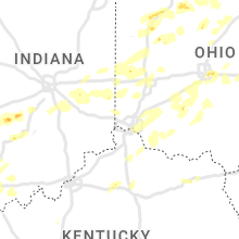
Hail Map for Saturday, May 21, 2022

Number of Impacted Households on 5/21/2022
0
Impacted by 1" or Larger Hail
0
Impacted by 1.75" or Larger Hail
0
Impacted by 2.5" or Larger Hail
Square Miles of Populated Area Impacted on 5/21/2022
0
Impacted by 1" or Larger Hail
0
Impacted by 1.75" or Larger Hail
0
Impacted by 2.5" or Larger Hail


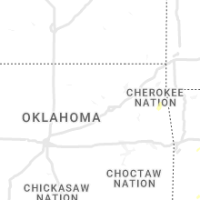


Cities Most Affected by Hail Storms of 5/21/2022
| Hail Size | Demographics of Zip Codes Affected | ||||||
|---|---|---|---|---|---|---|---|
| City | Count | Average | Largest | Pop Density | House Value | Income | Age |
| Errol, NH | 2 | 2.00 | 2.00 | 0 | $87k | $36.6k | 53.3 |
| Bessemer, AL | 1 | 2.00 | 2.00 | 272 | $82k | $42.2k | 39.9 |
| Novelty, OH | 1 | 1.75 | 1.75 | 236 | $207k | $71.6k | 49.9 |
| Medina, TX | 1 | 1.75 | 1.75 | 4 | $84k | $33.8k | 51.0 |
| Bandera, TX | 1 | 1.75 | 1.75 | 25 | $100k | $33.1k | 49.3 |
Hail and Wind Damage Spotted on 5/21/2022
Filter by Report Type:Hail ReportsWind Reports
States Impacted
Indiana, Missouri, Michigan, Illinois, South Carolina, North Carolina, Alabama, Kentucky, Virginia, Mississippi, Ohio, New York, Texas, Tennessee, Vermont, Pennsylvania, Florida, Arkansas, West Virginia, Maine, New Hampshire, LouisianaIndiana
| Local Time | Report Details |
|---|---|
| 8:30 AM EDT | Lightning strike hit house and caused fir in kosciusko county IN, 43.1 miles NW of Fort Wayne, IN |
| 1:30 PM CDT | Late report. multiple trees down blocking roadway in gibson county IN, 27.6 miles NNE of Evansville, IN |
| 2:45 PM EDT | Grain bin on top of house. report via twitter. time estimated from rada in owen county IN, 56.3 miles SW of Indianapolis, IN |
| 2:56 PM EDT | Jasper police reports power poles down on 34th street blocking the roadway. time estimated from rada in dubois county IN, 45.7 miles NE of Evansville, IN |
| 2:03 PM CDT | Small tree limbs blown dow in spencer county IN, 30.5 miles ENE of Evansville, IN |
| 3:03 PM EDT | Large trees and power line down. time estimated from rada in monroe county IN, 45.1 miles SW of Indianapolis, IN |
| 3:06 PM EDT | Spotter reports power lines down at the intersection of state route 56 and county road 600w in northwest dubois count in dubois county IN, 42.6 miles NE of Evansville, IN |
| 3:08 PM EDT | Large trees down report via twitter with video. trees knocked power lines dow in owen county IN, 39.6 miles SW of Indianapolis, IN |
| 3:10 PM EDT | Dispatch reports power lines down in holland. time estimated from rada in dubois county IN, 33.8 miles ENE of Evansville, IN |
| 3:20 PM EDT | Report from mping: 1-inch tree limbs broken; shingles blown of in monroe county IN, 47.2 miles SSW of Indianapolis, IN |
| 3:20 PM EDT | Received a report via social media of trees and powerlines down on fairfax and strain ridge rd south of smithville... i in monroe county IN, 51.8 miles SSW of Indianapolis, IN |
| 3:25 PM EDT | Buildings damaged. time estimated from rada in lawrence county IN, 57.3 miles SSW of Indianapolis, IN |
| 3:26 PM EDT | Tree fell on house. time estimated from rada in lawrence county IN, 66.4 miles NW of Louisville, KY |
| 3:29 PM EDT | Report from mping: 3-inch tree limbs broken; power poles broke in monroe county IN, 46.8 miles SSW of Indianapolis, IN |
| 3:30 PM EDT | Tree fell on house. time estimated from rada in morgan county IN, 27.6 miles SSW of Indianapolis, IN |
| 3:30 PM EDT | Large tree branches down. public reports high win in morgan county IN, 28.2 miles SSW of Indianapolis, IN |
| 3:38 PM EDT | 3 foot diameter tree fell on corner of house in alford... several trees and power lines down just southeast of prides creek par in pike county IN, 39.3 miles NNE of Evansville, IN |
| 3:40 PM EDT | Large area of trees down. time estimated from rada in brown county IN, 30.2 miles S of Indianapolis, IN |
| 3:48 PM EDT | Structural damage to steeple on chapel building and roof shingles of in johnson county IN, 29.5 miles SSE of Indianapolis, IN |
| 3:50 PM EDT | Trees and power lines are down in englis in crawford county IN, 46.6 miles WNW of Louisville, KY |
| 3:52 PM EDT | Public estimates 65 mph win in johnson county IN, 30.5 miles SSE of Indianapolis, IN |
| 3:53 PM EDT | Trees down. time estimated from rada in bartholomew county IN, 37.8 miles SSE of Indianapolis, IN |
| 3:53 PM EDT | Large tree limbs on house. report via twitter. time estimated from rada in shelby county IN, 30.2 miles SSE of Indianapolis, IN |
| 3:56 PM EDT | Numerous tree limbs down in the area... highway sign folded over. report via twitter. time estimated from rada in bartholomew county IN, 32.5 miles SSE of Indianapolis, IN |
| 3:56 PM EDT | Picture sent to us via social media of a large tree down blocking a road in edinburg in johnson county IN, 29.8 miles SSE of Indianapolis, IN |
| 3:56 PM EDT | Large tree limb down. wind estimation near 80 mph. time estimated from rada in bartholomew county IN, 37.8 miles SSE of Indianapolis, IN |
| 3:56 PM EDT | Received multiple pictures via social media of large tree limbs down on ne side of columbu in bartholomew county IN, 39.1 miles SSE of Indianapolis, IN |
| 4:00 PM EDT | Multiple trees dow in shelby county IN, 29.2 miles SSE of Indianapolis, IN |
| 4:03 PM EDT | Trees and power lines are down in mareng in crawford county IN, 43 miles NW of Louisville, KY |
| 4:05 PM EDT | Widespread multiple trees down. some on homes. estimated wind gust of 80+mph. time is estimate in decatur county IN, 36.2 miles SE of Indianapolis, IN |
| 4:07 PM EDT | Trees are down near milltow in crawford county IN, 39.1 miles NW of Louisville, KY |
| 4:10 PM EDT | Wide spread tree damage reported; front of a roof peeled off on old st rte 421; large trees blocking roads innumerous area. time estimated from rada in decatur county IN, 36.2 miles SE of Indianapolis, IN |
| 4:11 PM EDT | Winds at monroe lake 58 mph gust... also heavy rain with tree damag in monroe county IN, 48.2 miles SSW of Indianapolis, IN |
| 4:13 PM EDT | Numerous tree limbs down... some large... across are in shelby county IN, 34.1 miles SE of Indianapolis, IN |
| 4:15 PM EDT | Spotter estimates 65 mph wind in shelby county IN, 35.3 miles SE of Indianapolis, IN |
| 4:16 PM EDT | Trees down throughout the count in fayette county IN, 45.4 miles NW of Cincinnati, OH |
| 4:21 PM EDT | A tree fell on power lines and blocked williar avenu in harrison county IN, 28.1 miles NW of Louisville, KY |
| 4:25 PM EDT | Large trees down. estimated wind gust of 75+ mp in decatur county IN, 40 miles SE of Indianapolis, IN |
| 4:26 PM EDT | Several power poles downed along us route 421 between w county road 1050 n and the decatur county line. time estimated from rada in ripley county IN, 45.7 miles W of Cincinnati, OH |
| 4:30 PM EDT | Trees down in union county IN, 42.7 miles NNW of Cincinnati, OH |
| 4:39 PM EDT | Telephone poles down on south liberty pike. time estimated from rada in union county IN, 40.4 miles NNW of Cincinnati, OH |
| 4:42 PM EDT | Large tree downed along interstate 74 near mile marker 155. time estimated from rada in ripley county IN, 34.6 miles WNW of Cincinnati, OH |
| 4:45 PM EDT | Report of trees down near lancaster. picture received via social media. time estimated from rada in jefferson county IN, 58.4 miles WSW of Cincinnati, OH |
| 4:51 PM EDT | A scoreboard was blown down and a trailer was flipped over at east central high school. time estimated from rada in dearborn county IN, 27.7 miles WNW of Cincinnati, OH |
| 4:57 PM EDT | Trees uprooted in st. leon are in dearborn county IN, 27.5 miles WNW of Cincinnati, OH |
| 4:58 PM EDT | Wastewater plant had building demolished and several trees down. time estimated from rada in dearborn county IN, 23.4 miles WNW of Cincinnati, OH |
| 5:00 PM EDT | Several trees downed near us route 52 and state route 46. time estimated from rada in dearborn county IN, 23 miles WNW of Cincinnati, OH |
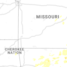
Missouri
| Local Time | Report Details |
|---|---|
| 9:00 AM CDT | Large tree down on house. time estimated from rada in texas county MO, 32 miles SW of Salem, MO |
| 1:00 PM CDT | Wind damage to roof of barn. about 30 feet of tinl torn off. time estimated by rada in stoddard county MO, 47.9 miles SSW of Cape Girardeau, MO |
| 2:50 PM CDT | Quarter sized hail reported near Kennett, MO, 75.2 miles N of Memphis, TN |
| 3:28 PM CDT | Quarter sized hail reported near Bourbon, MO, 38.7 miles NNE of Salem, MO, spotter stated that there was a brief occurrence of quarter sized hail in bourbon. it fell for approximately 5 seconds. |
Michigan
| Local Time | Report Details |
|---|---|
| 10:17 AM EDT | Chesterfield dispatch reported scattered trees down along gratiot ave between 21 mile and 24 mile rd in macomb county MI, 49.2 miles ESE of Flint, MI |
| 10:26 AM EDT | Dispatch reports numerous trees down throughout st. clair count in st. clair county MI, 54.7 miles ESE of Flint, MI |
Illinois
| Local Time | Report Details |
|---|---|
| 11:15 AM CDT | A few trees snapped or uprooted and large limbs blown down... a few houses with shingle damage... and one house with roof damag in perry county IL, 50.9 miles NNE of Cape Girardeau, MO |
| 12:56 PM CDT | Storm damage reported in white county IL, 31.3 miles WNW of Evansville, IN |
South Carolina
| Local Time | Report Details |
|---|---|
| 1:45 PM EDT | Newberry co dispatch reported a tree down on mt. pleasant rd and ringer rd north of pomaria. time estimate in newberry county SC, 67.7 miles SSW of Charlotte, NC |
| 2:20 PM EDT | Quarter sized hail reported near Fort Mill, SC, 16.6 miles SSW of Charlotte, NC, shamrock ct. near s. white st. |
| 2:31 PM EDT | Power lines down across the intersection of calvary road and indian branch road. event time estimated by kltx rada in darlington county SC, 74.7 miles N of Charleston, SC |
| 2:40 PM EDT | Fairfield co dispatch reported a tree down on catawba rd near lake wateree. exact location unknown. time estimate in fairfield county SC, 48.7 miles S of Charlotte, NC |
| 3:00 PM EDT | Tree down on old swamp rd near sandy run. exact location unknown. time estimate in calhoun county SC, 64.4 miles ENE of Augusta, GA |
| 3:12 PM EDT | Power lines down near the intersection of daniel chapel road and sc83. event time estimated by kltx rada in marlboro county SC, 87.1 miles ESE of Charlotte, NC |
| 3:28 PM EDT | Tree down on us hwy 601 and preference rd ne of st. matthew in calhoun county SC, 54.5 miles NW of Charleston, SC |
| 5:40 PM EDT | Tree limbs were downed on kenwood rd near church branch. time estimate in clarendon county SC, 24.3 miles NNW of Charleston, SC |
North Carolina
| Local Time | Report Details |
|---|---|
| 2:08 PM EDT | Quarter sized hail reported near Canton, NC, 51.4 miles NNW of Greenville, SC, picture on twitter shows estimated largest hail up to quarter-sized in canton. lots of pea to marble as well. |
| 3:33 PM EDT | Multiple trees down near the 13000 block of blues farm rd. time estimated by rada in scotland county NC, 82.1 miles ESE of Charlotte, NC |
| 3:36 PM EDT | Multiple trees down near the intersection of old wire rd and sneads grove rd. time estimated by rada in scotland county NC, 80.5 miles ESE of Charlotte, NC |
| 3:50 PM EDT | Quarter sized hail reported near China Grove, NC, 28 miles NNE of Charlotte, NC, social media report of quarter-sized hail in china grove. time based on radar. |
| 4:00 PM EDT | Several reports of trees and power lines down along patterson st. and hwy 152 in china grove. time estimated from rada in rowan county NC, 27.5 miles NNE of Charlotte, NC |
| 4:00 PM EDT | A tree knocked out power near the intersection of hannah pickett ave and safie 5th street. time estimated by rada in richmond county NC, 64.8 miles ESE of Charlotte, NC |
| 4:04 PM EDT | A tree fell down across the entire roadway. time estimated by rada in richmond county NC, 61 miles ESE of Charlotte, NC |
| 4:55 PM EDT | A tree was reported down near the intersection of us 301 n and pittman rd. time estimated by rada in johnston county NC, 28.4 miles ESE of Raleigh, NC |
| 5:18 PM EDT | A tree fell down on powerlines near the intersection of n charles st and reams ave. time estimated by rada in person county NC, 46.6 miles NNW of Raleigh, NC |
| 5:27 PM EDT | Quarter sized hail reported near Morrisville, NC, 11.4 miles WNW of Raleigh, NC, off airport blvd. |
| 5:34 PM EDT | Several trees down in mountain park from 534 pm to 552 p in surry county NC, 77.1 miles E of Bristol, TN |
| 5:40 PM EDT | A tree was reported down... along with power lines down... near the 5300 block of tobaccoville rd. time estimated by rada in forsyth county NC, 73.2 miles NNE of Charlotte, NC |
| 5:45 PM EDT | Powerlines down in the vicinity of pope rd and old salisbury rd. radar estimated tim in forsyth county NC, 64.8 miles NNE of Charlotte, NC |
| 6:00 PM EDT | Thunderstorm winds blew down one tree at the intersection of early lane and highway 26 in stokes county NC, 63.2 miles SSW of Roanoke, VA |
| 6:00 PM EDT | Thunderstorm winds blew down one tree at the intersection of chilton road and mountain roa in stokes county NC, 63.7 miles SSW of Roanoke, VA |
| 6:02 PM EDT | Thunderstorm winds blew down one tree at the intersection of king road and brown mountain roa in stokes county NC, 61.7 miles SSW of Roanoke, VA |
| 6:03 PM EDT | Thunderstorm winds blew down one tree at the intersection of flat shoals road and highway in stokes county NC, 65.4 miles SSW of Roanoke, VA |
| 6:06 PM EDT | Thunderstorm winds blew down one tree at the intersection of hall road and c c camp roa in stokes county NC, 62 miles SSW of Roanoke, VA |
| 6:08 PM EDT | Thunderstorm winds blew down one tree at the intersection of sheppard mill road and pitzer roa in stokes county NC, 60.1 miles SSW of Roanoke, VA |
| 6:09 PM EDT | Thunderstorm winds blew down one tree at the intersection of lynchburg road and lucius beasley roa in stokes county NC, 61.1 miles SSW of Roanoke, VA |
| 6:45 PM EDT | Powerlines down on the northside of roxboro. radar estimated tim in person county NC, 49.8 miles NNW of Raleigh, NC |
| 10:35 PM EDT | Tree down on sinclair ave in mario in mcdowell county NC, 64.1 miles S of Bristol, TN |
| 10:35 PM EDT | Trees down on bond street in mario in mcdowell county NC, 65.6 miles NNE of Greenville, SC |
Alabama
| Local Time | Report Details |
|---|---|
| 1:10 PM CDT | Dispatch reported a tree was knocked dow in houston county AL, 74 miles NW of Tallahassee, FL |
| 4:12 PM CDT | 2 trees down on alabama hwy 39 near williams r in sumter county AL, 60.2 miles SE of Starkville, MS |
| 5:20 PM CDT | Tree down at the corner of cox creek parkway and darby driv in lauderdale county AL, 0.3 miles E of Florence, AL |
| 6:08 PM CDT | Tree down across hwy 49 near chelsea ridge ln. time estimated by rada in shelby county AL, 20.4 miles SE of Birmingham, AL |
| 6:17 PM CDT | Trees down in the anderson community along highway 20 in lauderdale county AL, 24.7 miles ENE of Florence, AL |
| 6:18 PM CDT | Power company reports a fallen tree on power lines on the north side of hwy 280 along old hwy 280. time estimated by rada in shelby county AL, 16.9 miles SE of Birmingham, AL |
| 6:20 PM CDT | Trees down near county rd 49 and highway 6 in lauderdale county AL, 24.8 miles ENE of Florence, AL |
| 6:57 PM CDT | Half Dollar sized hail reported near Adger, AL, 24.7 miles W of Birmingham, AL, report of half-dollar sized hail in driftwood... al... near franklin ferry bridge. time estimated by radar. |
| 6:58 PM CDT | Ping Pong Ball sized hail reported near Bessemer, AL, 21.9 miles W of Birmingham, AL, ping ball sized hail reported at the donaldson correctional facility. time estimated by radar. |
| 7:03 PM CDT | Hen Egg sized hail reported near Bessemer, AL, 22.5 miles W of Birmingham, AL, photo on twitter of hail measured at 2 inches on taylors ferry rd near the black warrior river. time estimated by radar. |
Kentucky
| Local Time | Report Details |
|---|---|
| 2:34 PM EDT | Quarter sized hail reported near Frankfort, KY, 51.7 miles ENE of Louisville, KY, multiple reports of quarter sized hail in southeast franklin county. time estimated from radar. |
| 3:46 PM EDT | Dispatch reports tree down near hill road in western bourbon county. time estimated from rada in bourbon county KY, 44.5 miles NNW of Irvine, KY |
| 3:00 PM CDT | Quarter sized hail reported near Melber, KY, 51.4 miles ESE of Cape Girardeau, MO |
| 4:40 PM EDT | Storm damage reported in jefferson county KY, 17 miles N of Louisville, KY |
| 4:54 PM EDT | Spotter reports tree down on story avenue in louisville. picture received via social media. time estimated from rada in jefferson county KY, 18.8 miles N of Louisville, KY |
| 7:03 PM EDT | Trees and a power line down on big perry road. time estimated by rada in rowan county KY, 50.5 miles NE of Irvine, KY |
| 7:31 PM EDT | Multiple pictures sent in of healthy trees uprooted and blown down as well as snapped branches along state highway 17 in carter county KY, 58.6 miles NE of Irvine, KY |
Virginia
| Local Time | Report Details |
|---|---|
| 2:41 PM EDT | Mobile home destroyed. shed flipped onto several vehicles. time estimated from rada in wythe county VA, 59.2 miles ENE of Bristol, TN |
| 6:20 PM EDT | Trees down along i-85 near mile marker 3 in brunswick county VA, 39.9 miles S of Richmond, VA |
| 6:32 PM EDT | Trees dow in dinwiddie county VA, 34.5 miles SSE of Richmond, VA |
| 7:30 PM EDT | Tree down (most likely due to outflow in halifax county VA, 63.2 miles SE of Roanoke, VA |
| 8:05 PM EDT | Trees dow in southampton county VA, 50 miles W of Virginia Beach, VA |
| 8:54 PM EDT | Tree down covering both lanes of patrick henry highwa in nelson county VA, 58.9 miles ENE of Roanoke, VA |
| 9:05 PM EDT | Trees and power line downed on chick cove dr at puller hw in middlesex county VA, 58.4 miles NNW of Virginia Beach, VA |
| 9:10 PM EDT | Numerous trees downed on horseshoe bend rd in deltaville near the deltaville library. report via faceboo in middlesex county VA, 57.5 miles NNW of Virginia Beach, VA |
| 9:25 PM EDT | Tree reported down on blue chickory lan in nelson county VA, 72.2 miles NE of Roanoke, VA |
Mississippi
| Local Time | Report Details |
|---|---|
| 2:03 PM CDT | Quarter sized hail reported near Stonewall, MS, 81.7 miles E of Jackson, MS, hail as large as quarter size accumulating in stonewall. report via social media. |
| 2:49 PM CDT | Quarter sized hail reported near Petal, MS, 84.9 miles SE of Jackson, MS, hail was falling in and around petal with sizes ranging from pea size up to quarter size. |
| 2:50 PM CDT | Quarter sized hail reported near Meridian, MS, 70.7 miles S of Starkville, MS, social media picture of a hail that was quarter size... potentially slightly larger... that fell just north of marion. |
| 3:10 PM CDT | Tree downed... with dime size hail occurrin in jones county MS, 75.9 miles SE of Jackson, MS |
| 3:10 PM CDT | Quarter sized hail reported near Lauderdale, MS, 68.2 miles SSE of Starkville, MS, social media report of a windshield cracked by hail at least quarter size near dalewood in the lauderdale area. |
| 3:11 PM CDT | Trees downed on the north side of decatur... report via social medi in newton county MS, 63.6 miles E of Jackson, MS |
| 3:58 PM CDT | A tree was blown down on highway 528 east of the hal fire departmen in jasper county MS, 62.3 miles ESE of Jackson, MS |
| 8:00 PM CDT | Ping Pong Ball sized hail reported near Robinsonville, MS, 24.3 miles SSW of Memphis, TN, ping-pong ball sized hail near the intersection of highway 3 and highway 713. |
| 8:10 PM CDT | Quarter sized hail reported near Hernando, MS, 22.8 miles SSW of Memphis, TN |
Ohio
| Local Time | Report Details |
|---|---|
| 3:11 PM EDT | Quarter sized hail reported near Mansfield, OH, 59 miles NNE of Columbus, OH, report from mping: quarter (1.00 in.). |
| 3:12 PM EDT | Quarter sized hail reported near Mansfield, OH, 58.8 miles NNE of Columbus, OH |
| 3:20 PM EDT | Half Dollar sized hail reported near Sardinia, OH, 37.9 miles E of Cincinnati, OH |
| 3:29 PM EDT | Trees dow in clermont county OH, 25.9 miles SE of Cincinnati, OH |
| 3:32 PM EDT | Quarter sized hail reported near Columbus, OH, 6.6 miles E of Columbus, OH |
| 3:37 PM EDT | Social media report of 3 power poles toppled over on us route 68 between findlay and arlington. time estimated via rada in hancock county OH, 75 miles NNW of Columbus, OH |
| 3:39 PM EDT | Storm damage reported in allen county OH, 45 miles ESE of Fort Wayne, IN |
| 3:45 PM EDT | Quarter sized hail reported near Columbus, OH, 6.6 miles E of Columbus, OH |
| 3:46 PM EDT | Storm damage reported in montgomery county OH, 45.1 miles NNE of Cincinnati, OH |
| 3:47 PM EDT | Quarter sized hail reported near Williamsburg, OH, 24.8 miles E of Cincinnati, OH |
| 3:55 PM EDT | Barn damaged along greenville-palestine road. time of event estimated by rada in darke county OH, 67.4 miles N of Cincinnati, OH |
| 3:57 PM EDT | Large tree downed. power pole also downed at same location. time estimated from rada in allen county OH, 51 miles ESE of Fort Wayne, IN |
| 4:00 PM EDT | Large tree limb downed. time estimated by rada in brown county OH, 33.6 miles ESE of Cincinnati, OH |
| 4:00 PM EDT | Large tree branches dow in allen county OH, 55.4 miles ESE of Fort Wayne, IN |
| 4:01 PM EDT | Several trees downed in the greenville area. time estimated by rada in darke county OH, 68.8 miles N of Cincinnati, OH |
| 4:03 PM EDT | Trees downed at multiple locations across the county. time estimated by rada in licking county OH, 24.3 miles ENE of Columbus, OH |
| 4:07 PM EDT | Trees downed at multiple locations across the county. time estimated by rada in licking county OH, 15 miles E of Columbus, OH |
| 4:16 PM EDT | Half Dollar sized hail reported near Novelty, OH, 21 miles E of Cleveland, OH |
| 4:16 PM EDT | Golf Ball sized hail reported near Novelty, OH, 18.8 miles E of Cleveland, OH, social media report of golf ball sized hail in novelty township. |
| 4:20 PM EDT | Quarter sized hail reported near Novelty, OH, 18.2 miles E of Cleveland, OH |
| 4:23 PM EDT | Tree downed along stone road near rte 207. time estimated by rada in ross county OH, 37.4 miles S of Columbus, OH |
| 4:36 PM EDT | Several small trees and large limbs down. utility wires dow in hancock county OH, 70.7 miles NNW of Columbus, OH |
| 4:36 PM EDT | Tree downed along oakland terrace. time of event estimated by rada in pickaway county OH, 24 miles S of Columbus, OH |
| 4:37 PM EDT | Corrects previous tstm wnd dmg report from 3 n arlington. social media report of 3 power poles toppled over on us route 68 between findlay and arlington. time estimated in hancock county OH, 75 miles NNW of Columbus, OH |
| 4:43 PM EDT | Trees down in shelby county OH, 65.3 miles WNW of Columbus, OH |
| 4:45 PM EDT | Storm damage reported in shelby county OH, 63.7 miles WNW of Columbus, OH |
| 4:51 PM EDT | Quarter sized hail reported near Vanlue, OH, 74.1 miles NNW of Columbus, OH |
| 4:55 PM EDT | Partially decayed 3 foot tree fell on state route 235. time estimated from rada in logan county OH, 54.6 miles WNW of Columbus, OH |
| 4:55 PM EDT | Tree limb downed near westwood. time of event estimate in hamilton county OH, 5.5 miles WNW of Cincinnati, OH |
| 4:57 PM EDT | Multiple 8 inch to 12 inch diameter trees down around the cit in wyandot county OH, 61.6 miles NNW of Columbus, OH |
| 5:04 PM EDT | Quarter sized hail reported near Chardon, OH, 25.7 miles E of Cleveland, OH, report from mping: quarter (1.00 in.). |
| 5:07 PM EDT | Trees down in several areas including zanesfiel in logan county OH, 44.3 miles NW of Columbus, OH |
| 5:07 PM EDT | Tree down. time estimated from rada in crawford county OH, 66.9 miles N of Columbus, OH |
| 5:07 PM EDT | Tree down. time estimated from rada in wyandot county OH, 71.6 miles N of Columbus, OH |
| 5:09 PM EDT | Trees down in montgomery county OH, 50.3 miles NNE of Cincinnati, OH |
| 5:10 PM EDT | Numerous trees downed in sayler park... including on catalpa road... fernbank ave... and river roa in hamilton county OH, 10.5 miles W of Cincinnati, OH |
| 5:15 PM EDT | Trees down on blissfield road in coshocton county OH, 59.2 miles ENE of Columbus, OH |
| 5:16 PM EDT | 5 inch diameter healthy limb downed across state route 571. time estimated from rada in clark county OH, 54.6 miles W of Columbus, OH |
| 5:17 PM EDT | Quarter sized hail reported near Tipp City, OH, 58.1 miles NNE of Cincinnati, OH, one inch hail reported along with 0.78 inches of rainfall. time estimated from radar. |
| 5:17 PM EDT | Trees down in clark county OH, 54.6 miles W of Columbus, OH |
| 5:18 PM EDT | Several trees and wires down in sayler park in hamilton county OH, 11.3 miles WNW of Cincinnati, OH |
| 5:19 PM EDT | Quarter sized hail reported near Tipp City, OH, 57.9 miles W of Columbus, OH, at sr201 and us40. time estimated from radar. |
| 5:19 PM EDT | Large limb dow in marion county OH, 51.4 miles NNW of Columbus, OH |
| 5:21 PM EDT | Tree down on ca in preble county OH, 44.9 miles N of Cincinnati, OH |
| 5:30 PM EDT | Trees down in clark county OH, 42.9 miles W of Columbus, OH |
| 5:39 PM EDT | Storm chaser video shows trees and power lines downed on ohio state route 103 south of wiers road in celeryvill in huron county OH, 63.3 miles WSW of Cleveland, OH |
| 6:55 PM EDT | Awos station klnn willoughby lost nation airport measured a 50 kt thunderstorm wind gus in lake county OH, 20.2 miles NE of Cleveland, OH |
| 7:20 PM EDT | Trees down. time estimated from rada in columbiana county OH, 47 miles WNW of Pittsburgh, PA |
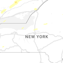
New York
| Local Time | Report Details |
|---|---|
| 3:26 PM EDT | Half Dollar sized hail reported near Constableville, NY, 49.6 miles NE of Syracuse, NY |
| 4:02 PM EDT | Half Dollar sized hail reported near Constableville, NY, 49.6 miles NE of Syracuse, NY, corrects previous hail report from 1 ssw constableville. |
| 4:05 PM EDT | Quarter sized hail reported near Central Square, NY, 16.6 miles N of Syracuse, NY, report: social media. |
| 4:10 PM EDT | Half Dollar sized hail reported near Central Square, NY, 16.6 miles N of Syracuse, NY, half dollar sized hail. report via social media. |
| 4:12 PM EDT | Quarter sized hail reported near Port Leyden, NY, 54.4 miles NE of Syracuse, NY |
| 5:15 PM EDT | Quarter sized hail reported near Churubusco, NY, 47.8 miles NW of Burlington, VT |
| 6:40 PM EDT | Downed tree on longview road in celoro in chautauqua county NY, 58.1 miles SSW of Buffalo, NY |
| 7:26 PM EDT | Tree down on state route 242 in the town of little valle in cattaraugus county NY, 44.9 miles S of Buffalo, NY |
| 7:34 PM EDT | Tree down on five mile road in the town of allegan in cattaraugus county NY, 56.9 miles SSE of Buffalo, NY |
| 7:53 PM EDT | Tree down on cadiz road in franklinvill in cattaraugus county NY, 44.8 miles SSE of Buffalo, NY |
| 7:53 PM EDT | Tree down on lyndon center road in the town of lyndo in cattaraugus county NY, 47.4 miles SSE of Buffalo, NY |
| 8:36 PM EDT | Tree dow in livingston county NY, 49.7 miles ESE of Buffalo, NY |
| 8:42 PM EDT | Tree dow in livingston county NY, 52.2 miles ESE of Buffalo, NY |
| 8:59 PM EDT | Tree limbs blown down. also half inch hai in livingston county NY, 58.3 miles ESE of Buffalo, NY |
| 9:14 PM EDT | Tree dow in chautauqua county NY, 57.3 miles SSW of Buffalo, NY |
Texas
| Local Time | Report Details |
|---|---|
| 3:14 PM CDT | Quarter sized hail reported near Mason, TX, 93 miles WSW of Killeen, TX |
| 4:32 PM CDT | Ping Pong Ball sized hail reported near Hamilton, TX, 43.1 miles NW of Killeen, TX, spotter reported 1.6 inch hail near fm 221 and fm 2414. |
| 4:54 PM CDT | Quarter sized hail reported near Harper, TX, 77.4 miles NW of San Antonio, TX, cocorahs observer reports mostly dime with a few hailstones to quarter sized. |
| 5:13 PM CDT | Quarter sized hail reported near Rio Vista, TX, 50.4 miles SW of Dallas, TX, spotter reported quarter sized hail in rio vista. |
| 5:19 PM CDT | Quarter sized hail reported near Harper, TX, 77.1 miles NW of San Antonio, TX, report from mping: quarter (1.00 in.). |
| 6:05 PM CDT | Ping Pong Ball sized hail reported near Ingram, TX, 68.4 miles NW of San Antonio, TX, cocorahs observer reports hail up to ping pong ball size. |
| 6:05 PM CDT | Half Dollar sized hail reported near Ingram, TX, 68.4 miles NW of San Antonio, TX, cocorahs observer reports hail up to the size of half dollars. |
| 7:04 PM CDT | Quarter sized hail reported near Waco, TX, 46.8 miles NE of Killeen, TX, 1 inch hail near loop 340 and university parks via spotternetwork. |
| 7:09 PM CDT | Waco regional (kact) pk wnd 29050k in mclennan county TX, 44.9 miles NE of Killeen, TX |
| 7:17 PM CDT | Quarter sized hail reported near Waco, TX, 48.6 miles NE of Killeen, TX |
| 7:40 PM CDT | Golf Ball sized hail reported near Medina, TX, 55.2 miles NW of San Antonio, TX, cooperative observer relayed a report of golf ball sized hail. |
| 8:05 PM CDT | Golf Ball sized hail reported near Bandera, TX, 47.8 miles WNW of San Antonio, TX, social media report of quarter to golf ball sized hail between medina and bandera. |
| 8:06 PM CDT | Roof torn off of building under construction in coolidg in limestone county TX, 71.3 miles S of Dallas, TX |
| 8:15 PM CDT | Multiple trees down blocking roads across northeast part of limestone count in limestone county TX, 73.9 miles SSE of Dallas, TX |
| 8:18 PM CDT | Mexia limestone county airport (klxy) pkwnd 30053k in limestone county TX, 80.2 miles SSE of Dallas, TX |
| 8:22 PM CDT | Ktxmexia17 - adana farms weather underground station measured peak wind of 71 mp in limestone county TX, 83.1 miles SSE of Dallas, TX |
| 8:25 PM CDT | Multiple trees down across park road 28 at ft. parker state par in limestone county TX, 77.9 miles ENE of Killeen, TX |
| 8:30 PM CDT | Ping Pong Ball sized hail reported near Hondo, TX, 39.3 miles W of San Antonio, TX, social media report with picture. |
| 9:15 PM CDT | Measured 60 mph wind gust at walmart distribution center southwest of palestin in anderson county TX, 64.6 miles WNW of Lufkin, TX |
| 9:20 PM CDT | Report from mping: 3-inch tree limbs broken; power poles broke in anderson county TX, 63.5 miles WNW of Lufkin, TX |
| 9:41 PM CDT | Trees and power lines dow in gregg county TX, 66.2 miles W of Shreveport, LA |
| 10:14 PM CDT | Several trees snappe in smith county TX, 65.4 miles NNW of Lufkin, TX |
| 10:25 PM CDT | Two trees down near broadway avenue. tree down near ut campu in smith county TX, 76.4 miles NNW of Lufkin, TX |
| 10:37 PM CDT | Trees and power lines dow in smith county TX, 57.6 miles NNW of Lufkin, TX |
| 10:37 PM CDT | *** 1 inj *** vehicle collision with a tree at the intersection of sh 42 and cr 468 in w rusk county. 1 minor injury reporte in rusk county TX, 53 miles NNW of Lufkin, TX |
| 10:38 PM CDT | Corrects previous tstm wnd dmg report from tyler. two trees down near broadway avenue. tree down near ut campu in smith county TX, 76.4 miles NNW of Lufkin, TX |
| 11:04 PM CDT | A tree was downed blocking fm 2011 near cr 2124d near lake cheroke in rusk county TX, 57.4 miles W of Shreveport, LA |
| 11:22 PM CDT | Quarter sized hail reported near Austin, TX, 51.5 miles S of Killeen, TX, report from mping: quarter (1.00 in.). |
| 11:48 PM CDT | A tree was downed on highway 4 in marion county TX, 30.1 miles WNW of Shreveport, LA |
| 2:55 AM CDT | Report of power line/power pole down at east and virginia street in victoria county TX, 74 miles NNE of Corpus Christi, TX |
| 3:00 AM CDT | Tree down on road. delmar dr and lone tree r in victoria county TX, 74 miles NNE of Corpus Christi, TX |
Tennessee
| Local Time | Report Details |
|---|---|
| 4:15 PM EDT | Quarter sized hail reported near Del Rio, TN, 50 miles E of Knoxville, TN, photo from facebook of estimated quarter size hail. |
| 4:18 PM EDT | Quarter sized hail reported near Afton, TN, 40.6 miles SW of Bristol, TN, report from mping: quarter (1.00 in.). |
| 4:53 PM EDT | Quarter sized hail reported near Piney Flats, TN, 12.5 miles SW of Bristol, TN, nickel to quarter size hail. |
| 4:13 PM CDT | Quarter sized hail reported near Obion, TN, 38.1 miles WNW of Mc Kenzie, TN, quarter-sized hail reported 5 miles south of troy. |
| 4:20 PM CDT | Quarter sized hail reported near Paris, TN, 18.1 miles NE of Mc Kenzie, TN, quarter-sized hail near the fairgrounds. |
| 4:20 PM CDT | Quarter sized hail reported near Paris, TN, 15.6 miles NE of Mc Kenzie, TN, quarter-sized hail reported near veterans dr. |
| 4:30 PM CDT | Multiple trees down on clayton town roa in henry county TN, 27.5 miles NE of Mc Kenzie, TN |
| 8:08 PM CDT | A couple of large trees down on the east side of dyersbur in dyer county TN, 47.5 miles W of Mc Kenzie, TN |
| 8:23 PM CDT | Quarter sized hail reported near Lawrenceburg, TN, 36.4 miles NNE of Florence, AL |
| 8:30 PM CDT | Downed powerline and leaning utility pole at stage road and elmore park roa in shelby county TN, 11.2 miles ENE of Memphis, TN |
| 8:33 PM CDT | Quarter sized hail reported near Millington, TN, 16.8 miles NNE of Memphis, TN, quarter-sized hail near west union road and wilkinsville road. |
| 9:40 PM CDT | Quarter sized hail reported near Sardis, TN, 49.5 miles SSE of Mc Kenzie, TN |
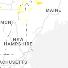
Vermont
| Local Time | Report Details |
|---|---|
| 5:30 PM EDT | Quarter sized hail reported near Alburgh, VT, 35.1 miles N of Burlington, VT |
| 5:35 PM EDT | Half Dollar sized hail reported near Swanton, VT, 37.5 miles N of Burlington, VT |
| 5:40 PM EDT | Multiple trees dow in chittenden county VT, 7.8 miles ESE of Burlington, VT |
| 5:45 PM EDT | Several trees dow in franklin county VT, 37.5 miles NNE of Burlington, VT |
| 6:30 PM EDT | 7-10 inch diameter trees snapped in hal in lamoille county VT, 36.2 miles ENE of Burlington, VT |
Pennsylvania
| Local Time | Report Details |
|---|---|
| 5:56 PM EDT | Several trees down. pea size hail also. time estimated from rada in erie county PA, 77.2 miles SSW of Buffalo, NY |
| 7:35 PM EDT | Multiple trees down in town. time estimated from rada in beaver county PA, 29.9 miles WNW of Pittsburgh, PA |
| 7:35 PM EDT | Two large trees snapped on mcclain road in lawrence county PA, 43.2 miles NW of Pittsburgh, PA |
| 8:05 PM EDT | Multiple trees dow in mercer county PA, 62.6 miles NNW of Pittsburgh, PA |
| 8:08 PM EDT | Several trees dow in crawford county PA, 75.6 miles N of Pittsburgh, PA |
| 8:15 PM EDT | Measured on home weather station in mercer county PA, 56 miles N of Pittsburgh, PA |
| 8:22 PM EDT | Tree fell on to a house on buffalo street. time estimated from rada in venango county PA, 66.3 miles N of Pittsburgh, PA |
| 8:25 PM EDT | Trees and wires down on sugarcreek drive in venango county PA, 68.1 miles N of Pittsburgh, PA |
| 8:25 PM EDT | Tree down on wires in butler county PA, 38.2 miles NNE of Pittsburgh, PA |
| 8:35 PM EDT | Trees down in richland townshi in clarion county PA, 53 miles NNE of Pittsburgh, PA |
| 8:41 PM EDT | Trees down all around kossut in clarion county PA, 62.2 miles NNE of Pittsburgh, PA |
| 8:44 PM EDT | Multiple trees down on boyers road in butler county PA, 46.4 miles N of Pittsburgh, PA |
| 8:51 PM EDT | A few trees down in western part of forest county. around 600 customers without powe in forest county PA, 78.7 miles NNE of Pittsburgh, PA |
| 8:53 PM EDT | Trees down across elk tw in clarion county PA, 62.7 miles NNE of Pittsburgh, PA |
Florida
| Local Time | Report Details |
|---|---|
| 6:02 PM EDT | Quarter sized hail reported near Oviedo, FL, 13.2 miles NE of Orlando, FL, trained spotter reports quarter sized hail the alafaya woods subdivision in oviedo. |
| 6:12 PM EDT | Half Dollar sized hail reported near Sanford, FL, 17.4 miles NNE of Orlando, FL, report of half dollar hail near the intersection of e lake mary blvd and brisson ave s in sanford relayed by broadcast media. time estimated via radar. |
| 6:12 PM EDT | Quarter sized hail reported near Sanford, FL, 18 miles NNE of Orlando, FL, report of quarter sized hail near the intersection of e lake mary blvd and skyway dr in sanford relayed by broadcast media. time estimated via radar. |
| 6:15 PM EDT | Quarter sized hail reported near Sanford, FL, 18 miles NNE of Orlando, FL, report of quarter sized hail near the intersection of e lake mary blvd and skyway dr in sanford relayed by broadcast media. time estimated via radar. |
| 6:17 PM EDT | Half Dollar sized hail reported near Sanford, FL, 17.4 miles NNE of Orlando, FL, report of half dollar hail near the intersection of e lake mary blvd and brisson ave s in sanford relayed by broadcast media. time estimated via radar. |
| 6:20 PM EDT | Half Dollar sized hail reported near Sanford, FL, 19 miles NNE of Orlando, FL, public report of half dollar size hail near 20th st and summerlin ave. received via twitter. |
| 6:20 PM EDT | Half Dollar sized hail reported near Sanford, FL, 16.9 miles NNE of Orlando, FL, public report via twitter of half dollar size hail near lake mary blvd and melonville ave. |
| 6:26 PM EDT | Quarter sized hail reported near Deland, FL, 29.9 miles N of Orlando, FL, public reports quarter sized hail near the intersection of 20th st and lolita st in orange city. |
| 6:30 PM EDT | Half Dollar sized hail reported near Deland, FL, 30.8 miles N of Orlando, FL, report of half dollar hail near the intersection of highway 17 and mcgregor rd in deland relayed by broadcast media. time estimated via radar. |
| 6:45 PM EDT | Quarter sized hail reported near Deland, FL, 34.9 miles N of Orlando, FL, public reports quarter sized hail near the intersection of n arlington and e pennsylvania ave in deland. |
| 7:14 PM EDT | Emergency manager relayed report of roof damage to two apartments on e alfred st in tavares. appears top layer of shingles lifted up... but larger roof structure remain in lake county FL, 27.1 miles NW of Orlando, FL |
| 7:14 PM EDT | Emergency manager relayed report of a large tree down across the road in the 300 block of dora ave... causing power line damage. pictures provide in lake county FL, 27.5 miles NW of Orlando, FL |
| 7:33 PM EDT | Quarter sized hail reported near Tavares, FL, 28.9 miles NW of Orlando, FL, report of quarter sized hail near the intersection of us route 441 and banning beach rd in tavares relayed by amateur radio. |
| 7:45 PM EDT | Tree and power line down near east woodland ave and sr 100. time estimated by rada in flagler county FL, 63.9 miles SSE of Jacksonville, FL |
Arkansas
| Local Time | Report Details |
|---|---|
| 5:21 PM CDT | Falling trees caused damage to a home and vehicle in frankli in izard county AR, 102 miles S of Salem, MO |
| 5:45 PM CDT | Quarter sized hail reported near Ash Flat, AR, 97.1 miles S of Salem, MO |
| 5:50 PM CDT | Quarter sized hail reported near Clinton, AR, 58.2 miles N of Little Rock, AR |
| 6:00 PM CDT | Em reports multiple trees down around ravende in lawrence county AR, 97.6 miles S of Salem, MO |
| 6:13 PM CDT | Video of large tree uproote in randolph county AR, 92.4 miles NNW of Memphis, TN |
| 6:15 PM CDT | Quarter sized hail reported near Marked Tree, AR, 33.6 miles NW of Memphis, TN, photo of quarter-sized hail in marked tree. |
| 6:34 PM CDT | Half Dollar sized hail reported near Batesville, AR, 75.3 miles NNE of Little Rock, AR |
| 6:38 PM CDT | Quarter sized hail reported near Hattieville, AR, 50 miles NNW of Little Rock, AR |
| 6:45 PM CDT | Powerlines down at east highland drive and martin luther king dr driv in craighead county AR, 56.3 miles NW of Memphis, TN |
| 6:58 PM CDT | Trees and power lines down in cornin in clay county AR, 84.2 miles SW of Cape Girardeau, MO |
| 7:00 PM CDT | Storm damage reported in clay county AR, 87.3 miles SW of Cape Girardeau, MO |
| 7:30 PM CDT | Powerlines down on highway 150 north of blythevill in mississippi county AR, 57.8 miles N of Memphis, TN |
| 7:30 PM CDT | A few trees were blown down in the mallett town are in faulkner county AR, 38.4 miles NNW of Little Rock, AR |
| 8:39 PM CDT | A tree was blown down on otto roa in faulkner county AR, 19.7 miles N of Little Rock, AR |
| 8:44 PM CDT | Several trees dow in howard county AR, 8.2 miles NW of Nashville, AR |
| 8:46 PM CDT | Several trees down completely blocking hwy 36 in howard county AR, 6.5 miles NNW of Nashville, AR |
| 8:55 PM CDT | A tree was blown down along highway 31 in lonoke county AR, 26.5 miles NE of Little Rock, AR |
| 9:10 PM CDT | Multiple power lines down in nashville up toward center poin in howard county AR, 0.6 miles SSW of Nashville, AR |
| 10:00 PM CDT | Trees were down on highway 278 near the yancy communit in hempstead county AR, 7.5 miles SSE of Nashville, AR |
| 10:20 PM CDT | Quarter sized hail reported near Redfield, AR, 22 miles SSE of Little Rock, AR |
| 10:22 PM CDT | Storm damage reported in miller county AR, 35.3 miles SSW of Nashville, AR |
| 10:40 PM CDT | Trees reported down at the intersection of miller county 10 and miller county 2 in miller county AR, 43.3 miles S of Nashville, AR |
| 10:40 PM CDT | Numerous trees reported down across roadways in miller county... including mc roads 237... 362... 250... and 1 in miller county AR, 39.9 miles S of Nashville, AR |
| 10:58 PM CDT | Trees down across the 3300 block of highway 35 in hempstead county AR, 35 miles SSE of Nashville, AR |
| 11:05 PM CDT | Numerous trees reported down across nevada count in nevada county AR, 28.7 miles ESE of Nashville, AR |
| 11:10 PM CDT | A tree was downed on highway 29 near county road 89 south of lewisvill in lafayette county AR, 45.9 miles SSE of Nashville, AR |
| 11:30 PM CDT | A tree was downed on highway 82 near the fairgrounds near stamp in lafayette county AR, 45.1 miles SSE of Nashville, AR |
| 11:35 PM CDT | A tree was downed near the intersection of cr 45 and cr 117 north of mcnei in columbia county AR, 50 miles SE of Nashville, AR |
| 12:23 AM CDT | A tree was downed on highway 98 in emerso in columbia county AR, 51.4 miles NE of Shreveport, LA |
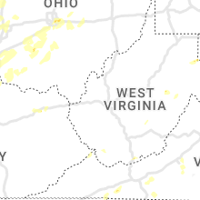
West Virginia
| Local Time | Report Details |
|---|---|
| 6:23 PM EDT | The roof of a speedway gas station collapse in wyoming county WV, 52.8 miles S of Charleston, WV |
| 9:37 PM EDT | Two reports of trees down along trough roa in hardy county WV, 52.4 miles ENE of Elkins, WV |
Maine
| Local Time | Report Details |
|---|---|
| 7:00 PM EDT | Several trees down on rt 2 in franklin county ME, 106.8 miles WNW of Bangor, ME |
| 7:36 PM EDT | Multiple trees dow in franklin county ME, 88.6 miles WNW of Bangor, ME |
| 7:36 PM EDT | One power line dow in franklin county ME, 87.5 miles WNW of Bangor, ME |
| 7:36 PM EDT | Multiple trees down and one tree on fir in franklin county ME, 84.4 miles WNW of Bangor, ME |
| 7:55 PM EDT | Corrected for time based on mesonet observations of strongest wind gusts. multiple trees down and one tree on fir in franklin county ME, 84.4 miles WNW of Bangor, ME |
| 8:00 PM EDT | Multiple trees down on wire in somerset county ME, 68.9 miles WNW of Bangor, ME |
| 8:00 PM EDT | A couple trees down and debris in the roa in somerset county ME, 69.1 miles WNW of Bangor, ME |
| 8:04 PM EDT | One tree and wire dow in somerset county ME, 65.8 miles NW of Bangor, ME |
New Hampshire
| Local Time | Report Details |
|---|---|
| 7:10 PM EDT | Ping Pong Ball sized hail reported near Colebrook, NH, 89.6 miles ENE of Burlington, VT, dented car hood. |
| 7:15 PM EDT | Trees and wires down on rt 14 in coos county NH, 97.6 miles ENE of Burlington, VT |
| 7:15 PM EDT | Trees and wires down on rt 14 in coos county NH, 93 miles ENE of Burlington, VT |
| 7:15 PM EDT | Trees and wires eown in multiple locations along rt in coos county NH, 103.2 miles ENE of Burlington, VT |
| 7:20 PM EDT | Several reports of trees and wires down in colebroo in coos county NH, 89.8 miles ENE of Burlington, VT |
| 7:20 PM EDT | Hen Egg sized hail reported near Errol, NH, 96.6 miles NNW of Portland, ME, reported by amateur radio. 2 inches measured hail outside dixville notch. |
| 7:26 PM EDT | Hen Egg sized hail reported near Errol, NH, 98.1 miles ENE of Burlington, VT, reported by amateur radio. large hail fell for 6 minutes. largest stones between 1.75 inches and 2 inches. |
| 7:26 PM EDT | Winds blew down trees as large as 8 inches in diamete in coos county NH, 98.1 miles ENE of Burlington, VT |
| 7:35 PM EDT | Trees down on the north side of errol. time estimated based on rada in coos county NH, 89 miles NNW of Portland, ME |
| 8:06 PM EDT | Ping Pong Ball sized hail reported near Lancaster, NH, 81.7 miles E of Burlington, VT, reported by amateur radio. big hail fell for 2-3 minutes in lancaster. |
| 10:30 PM EDT | Half Dollar sized hail reported near Gorham, NH, 64.3 miles NW of Portland, ME, time estimated based on radar. |
Louisiana
| Local Time | Report Details |
|---|---|
| 12:10 AM CDT | Trees were downed on at least a couple of homes on ed road between rodessa and hossto in caddo county LA, 29.3 miles NNW of Shreveport, LA |
Connect with Interactive Hail Maps