

Hail Map for Tuesday, October 7, 2014

Number of Impacted Households on 10/7/2014
0
Impacted by 1" or Larger Hail
0
Impacted by 1.75" or Larger Hail
0
Impacted by 2.5" or Larger Hail
Square Miles of Populated Area Impacted on 10/7/2014
0
Impacted by 1" or Larger Hail
0
Impacted by 1.75" or Larger Hail
0
Impacted by 2.5" or Larger Hail

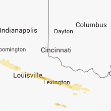


Cities Most Affected by Hail Storms of 10/7/2014
| Hail Size | Demographics of Zip Codes Affected | ||||||
|---|---|---|---|---|---|---|---|
| City | Count | Average | Largest | Pop Density | House Value | Income | Age |
| Georgetown, KY | 3 | 2.08 | 2.75 | 272 | $110k | $48.3k | 34.2 |
| Mount Sterling, KY | 2 | 1.75 | 1.75 | 154 | $86k | $33.3k | 38.0 |
| Charleston, WV | 1 | 2.50 | 2.50 | 361 | $83k | $35.1k | 43.1 |
| Culloden, WV | 1 | 2.00 | 2.00 | 149 | $89k | $39.0k | 40.4 |
| Buckner, KY | 1 | 1.75 | 1.75 | 309 | $190k | $71.0k | 37.2 |
| Louisa, KY | 1 | 1.75 | 1.75 | 58 | $58k | $22.5k | 39.8 |
| Eminence, KY | 1 | 1.75 | 1.75 | 102 | $79k | $31.3k | 37.8 |
| Pleasureville, KY | 1 | 1.75 | 1.75 | 36 | $80k | $41.3k | 40.7 |
| Stamping Ground, KY | 1 | 1.75 | 1.75 | 56 | $84k | $37.0k | 40.4 |
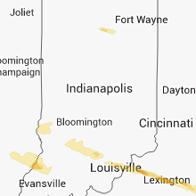
Hail and Wind Damage Spotted on 10/7/2014
Filter by Report Type:Hail ReportsWind Reports
States Impacted
Illinois, Tennessee, Indiana, Kentucky, Ohio, West Virginia, Virginia, Maryland, Massachusetts, Oklahoma, ArkansasIllinois
| Local Time | Report Details |
|---|---|
| 8:06 AM CDT | 6 powerpoles... powerlines... and trees down north of flora. from flora to the west power is ou in clay county IL, 54.9 miles S of Mattoon, IL |
Tennessee
| Local Time | Report Details |
|---|---|
| 8:14 AM CDT | Quarter sized hail reported near Memphis, TN, 8.3 miles NE of Memphis, TN, quarter size hail reported by mpd near frayser and raleigh. |
| 11:35 PM CDT | Public estimated winds up to 70 mph in cross plains in robertson county TN, 26.2 miles NNE of Nashville, TN |
| 11:38 PM CDT | Spotter reported small tree limbs down and winds estimated up to 60 mph in robertson county TN, 26.5 miles NNE of Nashville, TN |
| 11:40 PM CDT | Quarter sized hail reported near Cross Plains, TN, 26.2 miles NNE of Nashville, TN, public reported hail slightly larger than quarter size in cross plains |
| 12:10 AM CDT | Quarter sized hail reported near Gallatin, TN, 23.5 miles NE of Nashville, TN, quarter size hail reported in gallatin via spotternetwork |
| 12:39 AM CDT | Quarter sized hail reported near Gallatin, TN, 22.2 miles NE of Nashville, TN, two reports of quarter size hail around gallatin |
| 12:48 AM CDT | Quarter sized hail reported near Gallatin, TN, 24.2 miles ENE of Nashville, TN, nickel to quarter size hail reported at odoms bend road at steam plant road |
| 1:00 AM CDT | Quarter sized hail reported near Lebanon, TN, 25.8 miles E of Nashville, TN, public report of quarter size hail in lebanon |
| 3:26 AM CDT | Trees were blown down near hampshir in maury county TN, 47.1 miles SW of Nashville, TN |
| 4:30 AM EDT | Several trees reported down near the city of dayto in rhea county TN, 35 miles NNE of Chattanooga, TN |
| 3:35 AM CDT | A spotter reported a 60 mph wind gust in mount pleasan in maury county TN, 48.5 miles SSW of Nashville, TN |
| 4:05 AM CDT | Several trees down just south of dunla in sequatchie county TN, 20.1 miles NNW of Chattanooga, TN |
Indiana
| Local Time | Report Details |
|---|---|
| 9:40 AM CDT | Wind gust estimated 60 mph. small hail covering the ground to the point where individuals are using snow shovels to remove it from the sidewalk in gibson county IN, 24.3 miles NNE of Evansville, IN |
| 10:50 AM EDT | Quarter sized hail reported near Stendal, IN, 32 miles NE of Evansville, IN, quarter size hail and assoicated wind gusts 30 mph. |
| 1:05 PM EDT | Quarter sized hail reported near Odon, IN, 69.7 miles NNE of Evansville, IN, winds were also estimated at 50 mph. |
| 1:05 PM EDT | Quarter sized hail reported near Crane, IN, 70.3 miles SSW of Indianapolis, IN, rotation was also noted in clouds. |
| 2:32 PM EDT | Quarter sized hail reported near Memphis, IN, 34.1 miles N of Louisville, KY, broadcast media relayed report of one inch hail in memphis |
| 2:40 PM EDT | Ham relayed reports of an 18 inch in diameter tree down in a yard as well as other trees down in the area. multiple power outages with estimated 60mph winds and pea siz in clark county IN, 32 miles N of Louisville, KY |
| 3:25 PM EDT | Half Dollar sized hail reported near Rochester, IN, 62.2 miles W of Fort Wayne, IN |
| 4:05 PM EDT | Quarter sized hail reported near Akron, IN, 48.7 miles W of Fort Wayne, IN |
| 4:30 PM EDT | Quarter sized hail reported near North Manchester, IN, 38.2 miles W of Fort Wayne, IN |
| 5:05 PM EDT | Quarter sized hail reported near Huntington, IN, 24.9 miles WSW of Fort Wayne, IN |
| 5:05 PM EDT | Several 2 to 4 inch diameter tree limbs downe in huntington county IN, 24.9 miles WSW of Fort Wayne, IN |
Kentucky
| Local Time | Report Details |
|---|---|
| 2:54 PM EDT | Multiple trees down in oldham county KY, 35.9 miles NNE of Louisville, KY |
| 3:07 PM EDT | Golf Ball sized hail reported near Eminence, KY, 39.8 miles NE of Louisville, KY, windshield cracked on car due to hail. |
| 3:32 PM EDT | Quarter sized hail reported near Frankfort, KY, 54.9 miles ENE of Louisville, KY, pea to quarter size hail in the peaks mill area |
| 3:40 PM EDT | Svrl lg trees down se part of county in owen county KY, 45.2 miles S of Cincinnati, OH |
| 3:40 PM EDT | Report of barns down trees down and homes damaged on stonetown road in scott county KY, 55.4 miles NW of Irvine, KY |
| 3:40 PM EDT | Several trees down near switzer and bald knob. powerlines down near switzer to in franklin county KY, 55.7 miles ENE of Louisville, KY |
| 3:48 PM EDT | One tree down in grant county KY, 41.9 miles S of Cincinnati, OH |
| 3:55 PM EDT | Storm damage reported in mason county KY, 50.3 miles SE of Cincinnati, OH |
| 3:56 PM EDT | Pea size hail also reporte in mason county KY, 51.9 miles SE of Cincinnati, OH |
| 4:09 PM EDT | Barns and small buildings blown down in the wornall lane area as well as several trees down in harrison county KY, 50.7 miles SSE of Cincinnati, OH |
| 4:12 PM EDT | Numerous power lines and power poles down across the city with power out citywide in bourbon county KY, 38.5 miles NNW of Irvine, KY |
| 4:13 PM EDT | Quarter sized hail reported near Paris, KY, 38.5 miles NNW of Irvine, KY |
| 4:15 PM EDT | Downed trees blocking mayme lane in lincoln county KY, 48.2 miles WSW of Irvine, KY |
| 4:15 PM EDT | 15 to 20 structures damaged on vine street in paris in bourbon county KY, 38.5 miles NNW of Irvine, KY |
| 4:30 PM EDT | Trees down with a road closed near sharpsubrg. also barn roofs were reported to have been blown of in bath county KY, 34.6 miles N of Irvine, KY |
| 4:38 PM EDT | Quarter sized hail reported near Crab Orchard, KY, 33.7 miles WSW of Irvine, KY |
| 4:45 PM EDT | A tree was blown down on a hous in bath county KY, 32.5 miles NNE of Irvine, KY |
| 4:52 PM EDT | Quarter sized hail reported near Brodhead, KY, 30.7 miles SW of Irvine, KY |
| 4:54 PM EDT | Multiple trees were blown down onto mudlick road about halfway between olympia springs and salt lic in bath county KY, 32.8 miles NE of Irvine, KY |
| 5:00 PM EDT | Several large limbs down due to strong gusty wind in greenup county KY, 76.9 miles WNW of Charleston, WV |
| 5:43 PM EDT | Trees down in the industrial par in greenup county KY, 64.2 miles W of Charleston, WV |
| 5:45 PM EDT | A large tree limb was blown down onto a vehicle in downtown hazard. the time of the event is estimated from rada in perry county KY, 52.7 miles SE of Irvine, KY |
| 6:17 PM EDT | Golf Ball sized hail reported near Buckner, KY, 31.2 miles NNE of Louisville, KY, oldham county dispatch received several reports of rotation and funnel clouds across the county. also reported golf ball sized hail. |
| 6:30 PM EDT | Half Dollar sized hail reported near Denniston, KY, 30.1 miles ENE of Irvine, KY |
| 6:41 PM EDT | Quarter sized hail reported near Eminence, KY, 39.8 miles NE of Louisville, KY |
| 6:44 PM EDT | Golf Ball sized hail reported near Pleasureville, KY, 41.4 miles NE of Louisville, KY |
| 7:08 PM EDT | Golf Ball sized hail reported near Mount Sterling, KY, 28.5 miles N of Irvine, KY |
| 7:15 PM EDT | Golf Ball sized hail reported near Stamping Ground, KY, 56.6 miles NW of Irvine, KY |
| 7:15 PM EDT | Ping Pong Ball sized hail reported near La Grange, KY, 33.6 miles NE of Louisville, KY |
| 7:20 PM EDT | Golf Ball sized hail reported near Georgetown, KY, 48.9 miles NW of Irvine, KY |
| 7:23 PM EDT | Baseball sized hail reported near Georgetown, KY, 46.7 miles NW of Irvine, KY |
| 7:33 PM EDT | Quarter sized hail reported near Owingsville, KY, 29.6 miles NNE of Irvine, KY |
| 8:05 PM EDT | Quarter sized hail reported near Mount Sterling, KY, 24.9 miles N of Irvine, KY |
| 8:05 PM EDT | Golf Ball sized hail reported near Georgetown, KY, 46.7 miles NW of Irvine, KY |
| 8:05 PM EDT | Quarter sized hail reported near Martha, KY, 61.3 miles ENE of Irvine, KY, one inch size hail reported. |
| 8:07 PM EDT | Roof blown off garage... chimney knocked off house... and several trees snapped off. damage occured in west liberty on highway 460 wes in morgan county KY, 41.2 miles ENE of Irvine, KY |
| 8:08 PM EDT | Quarter sized hail reported near West Liberty, KY, 39.2 miles ENE of Irvine, KY |
| 8:08 PM EDT | Golf Ball sized hail reported near Mount Sterling, KY, 24.9 miles N of Irvine, KY |
| 8:23 PM EDT | Quarter sized hail reported near Sandy Hook, KY, 52 miles ENE of Irvine, KY |
| 8:23 PM EDT | Large tree limbs downe in elliott county KY, 52 miles ENE of Irvine, KY |
| 8:25 PM EDT | Half Dollar sized hail reported near Jeffersonville, KY, 23 miles NNE of Irvine, KY |
| 8:31 PM EDT | One tree was reported to have been blown dow in johnson county KY, 57.2 miles E of Irvine, KY |
| 8:40 PM EDT | Half Dollar sized hail reported near Blaine, KY, 65.6 miles ENE of Irvine, KY, hail to the half dollar size reported in downtown blaine. |
| 8:50 PM EDT | Quarter sized hail reported near Mount Sterling, KY, 24.9 miles N of Irvine, KY |
| 8:50 PM EDT | Golf Ball sized hail reported near Louisa, KY, 56.8 miles WSW of Charleston, WV, golf ball size hail reported on ky 1690 near the martin county line. |
| 9:13 PM EDT | Quarter sized hail reported near Salyersville, KY, 50.8 miles E of Irvine, KY |
Ohio
| Local Time | Report Details |
|---|---|
| 4:48 PM EDT | Trees down in scioto county OH, 81.2 miles ESE of Cincinnati, OH |
| 5:10 PM EDT | Trees down in scioto county OH, 68.1 miles WNW of Charleston, WV |
| 5:11 PM EDT | Trees down in scioto county OH, 70.6 miles WNW of Charleston, WV |
West Virginia
| Local Time | Report Details |
|---|---|
| 6:15 PM EDT | Quarter sized hail reported near Culloden, WV, 22.4 miles W of Charleston, WV, strong gusty winds to 60 mph and one inch hail. |
| 6:15 PM EDT | Strong gusty winds to 60 mph and one inch hai in lincoln county WV, 22.4 miles W of Charleston, WV |
| 6:28 PM EDT | Multiple trees and power lines down along chestnut lane in kanawha county WV, 5.2 miles WSW of Charleston, WV |
| 6:40 PM EDT | Hen Egg sized hail reported near Culloden, WV, 21.3 miles W of Charleston, WV, gusty winds and two inch hail. |
| 8:15 PM EDT | Large pine tree uprooted. time estimated from rada in lincoln county WV, 25.5 miles W of Charleston, WV |
| 8:53 PM EDT | Tennis Ball sized hail reported near Charleston, WV, 5.4 miles WSW of Charleston, WV, elongated 2.5 inch hail measured at nws office. |
| 10:40 PM EDT | Numerous trees and powerlines down. outhouse taken out. there were several callers to the 911 center that reported seeing some sort of funnel cloud. search for possible in raleigh county WV, 56.6 miles SSE of Charleston, WV |
| 10:57 PM EDT | A trained storm spotter reported about ten trees and a power pole blown down near the highway 20 bridge crossing bluestone lak in summers county WV, 58.7 miles WNW of Roanoke, VA |
| 10:57 PM EDT | Numerous trees and powerlines down. outhouse taken out. there were several callers to the 911 center that reported seeing some sort of funnel cloud. search for possible in raleigh county WV, 56.6 miles SSE of Charleston, WV |
| 11:44 PM EDT | Trees down and damage to a traile in mercer county WV, 68 miles SSE of Charleston, WV |
| 11:46 PM EDT | Numerous trees down and an outbuilding destroye in mercer county WV, 66.4 miles W of Roanoke, VA |
| 11:50 PM EDT | Quarter sized hail reported near Bradshaw, WV, 55.8 miles NNE of Bristol, TN |
Virginia
| Local Time | Report Details |
|---|---|
| 8:53 PM EDT | Tree down across road at corner of miller school rd and samuel miller rd in albemarle county VA, 67.2 miles WNW of Richmond, VA |
Maryland
| Local Time | Report Details |
|---|---|
| 11:03 PM EDT | Tree down across colton point rd in the 22000 block in st. marys county MD, 70.9 miles S of Baltimore, MD |
| 12:00 AM EDT | Wires and tree limbs down in caroline county MD, 51.7 miles WNW of Ocean City, MD |
Massachusetts
| Local Time | Report Details |
|---|---|
| 4:35 AM EDT | Large tree down across us 202 in hampden county MA, 71.7 miles WNW of Providence, RI |
| 4:45 AM EDT | Power outage due to tree down on wires along feeding hill road in hampden county MA, 71.7 miles WNW of Providence, RI |
| 4:59 AM EDT | Large tree down on belanger road in hampshire county MA, 73.4 miles WNW of Providence, RI |
| 4:59 AM EDT | Large tree down on belanger road in hampshire county MA, 73.4 miles WNW of Providence, RI |
| 5:07 AM EDT | Power lines down on car on mountain road as well as multiple trees down in and around town in hampshire county MA, 72.1 miles WNW of Providence, RI |
| 5:09 AM EDT | Power lines down on dodwells road in hampshire county MA, 58.1 miles ESE of Schenectady, NY |
| 5:09 AM EDT | Tree and wires down on house on mockanum road in hampshire county MA, 70.2 miles WNW of Providence, RI |
| 5:19 AM EDT | Tree down on route 116 blocking the road in franklin county MA, 67.3 miles ESE of Schenectady, NY |
| 5:20 AM EDT | Trees down on ventura street in hampden county MA, 59.9 miles WNW of Providence, RI |
Oklahoma
| Local Time | Report Details |
|---|---|
| 4:55 AM CDT | Quarter sized hail reported near Stilwell, OK, 28 miles NNW of Fort Smith, AR |
Arkansas
| Local Time | Report Details |
|---|---|
| 6:37 AM CDT | Ping Pong Ball sized hail reported near Mulberry, AR, 21.2 miles ENE of Fort Smith, AR, at mile marker 21 on hwy 40 northwest of mulberry. |
Connect with Interactive Hail Maps