

Hail Map for Thursday, August 16, 2012

Number of Impacted Households on 8/16/2012
0
Impacted by 1" or Larger Hail
0
Impacted by 1.75" or Larger Hail
0
Impacted by 2.5" or Larger Hail
Square Miles of Populated Area Impacted on 8/16/2012
0
Impacted by 1" or Larger Hail
0
Impacted by 1.75" or Larger Hail
0
Impacted by 2.5" or Larger Hail


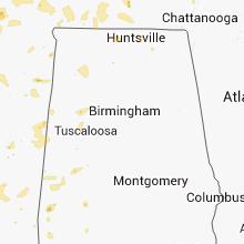


Cities Most Affected by Hail Storms of 8/16/2012
| Hail Size | Demographics of Zip Codes Affected | ||||||
|---|---|---|---|---|---|---|---|
| City | Count | Average | Largest | Pop Density | House Value | Income | Age |
| Pierce City, MO | 3 | 2.17 | 2.75 | 42 | $57k | $32.1k | 39.6 |
| Edgewood, NM | 1 | 4.50 | 4.50 | 68 | $145k | $48.3k | 44.3 |
| Gorham, IL | 1 | 2.50 | 2.50 | 16 | $30k | $30.5k | 41.0 |
| Terre Haute, IN | 1 | 1.75 | 1.75 | 254 | $78k | $40.1k | 40.4 |
| Marshfield, MO | 1 | 1.75 | 1.75 | 81 | $85k | $35.0k | 39.4 |
| Marine, IL | 1 | 1.75 | 1.75 | 55 | $81k | $40.6k | 40.2 |
| Monett, MO | 1 | 1.75 | 1.75 | 137 | $72k | $32.5k | 35.5 |
Hail and Wind Damage Spotted on 8/16/2012
Filter by Report Type:Hail ReportsWind Reports
States Impacted
Indiana, Florida, Missouri, Arkansas, Illinois, Oklahoma, South Carolina, California, Alabama, Mississippi, Georgia, New Mexico, Tennessee, Kentucky, Utah, LouisianaIndiana
| Local Time | Report Details |
|---|---|
| 11:25 AM EDT | Tree downed blocking both lanes of traffic at the 2300 block of north 25th st. downed tree also blocking one lane of traffic on elmwood av in tippecanoe county IN, 58.5 miles NW of Indianapolis, IN |
| 11:28 AM EDT | Tree downed blocking cr 1000 e just south of sr 25. time estimated from rada in tippecanoe county IN, 61.6 miles NNW of Indianapolis, IN |
| 11:30 AM EDT | Tree downed blocking cr 775 e just south of sr 26. time estimated from rada in tippecanoe county IN, 54.9 miles NW of Indianapolis, IN |
| 5:16 PM EDT | Golf Ball sized hail reported near Terre Haute, IN, 54.4 miles E of Mattoon, IL |
| 5:22 PM EDT | Quarter sized hail reported near Terre Haute, IN, 53.2 miles E of Mattoon, IL |
| 5:35 PM EDT | Quarter sized hail reported near Spencer, IN, 49.4 miles SW of Indianapolis, IN, water covering road to unknown depth...able to drive through fine |
| 5:50 PM EDT | Eight inch diameter limb downe in monroe county IN, 47.4 miles SSW of Indianapolis, IN |
| 6:00 PM EDT | Three foot diameter tree downe in greene county IN, 62.9 miles SW of Indianapolis, IN |
| 6:07 PM EDT | Storm damage reported in sullivan county IN, 63.5 miles SE of Mattoon, IL |
| 6:07 PM EDT | Storm damage reported in sullivan county IN, 61.7 miles ESE of Mattoon, IL |
| 6:30 PM EDT | Trees down at 80 west 15 street in knox county IN, 48.6 miles N of Evansville, IN |
| 6:31 PM EDT | Large tree down on west 3rd...sewer pump out on southwest side of town...time estimated in knox county IN, 57.1 miles NNE of Evansville, IN |
| 6:40 PM EDT | Tree with lines down at 8th and johnson...time approx in knox county IN, 45.2 miles NNE of Evansville, IN |
| 7:15 PM EDT | Spotter estimated 50-60 mph wind gusts and reported several 1.5 - 2 inch limbs down on roads. heavy rain and cloud-to-ground lightning as wel in orange county IN, 63.4 miles NW of Louisville, KY |
| 7:15 PM EDT | Spotter estimated 50-60 mph wind gusts and reported several 1.5 - 2 inch limbs down on roads. heavy rain and cloud-to-ground lightning as wel in orange county IN, 62.2 miles NW of Louisville, KY |
| 7:25 PM EDT | Tree reported down across hwy. 231 near hayesvill in dubois county IN, 49.3 miles NE of Evansville, IN |
| 7:30 PM EDT | Trees reported down in town of dubois. fire department estimates 50 mph wind in dubois county IN, 52.9 miles NE of Evansville, IN |
| 7:40 PM EDT | Trees and street signs down in freetown in jackson county IN, 55 miles S of Indianapolis, IN |
| 7:48 PM EDT | Storm damage reported in crawford county IN, 38.7 miles NW of Louisville, KY |
| 7:08 PM CDT | Numerous tree limbs and branches down in rockport...many gusts over 58 mp in spencer county IN, 28.9 miles ESE of Evansville, IN |
Florida
| Local Time | Report Details |
|---|---|
| 1:50 PM EDT | County roads department reported a tree down on se 58th avenue between highway 42 and se 177th plac in marion county FL, 48.1 miles NW of Orlando, FL |
| 3:50 PM EDT | 67 kt/77 mph thunderstorm wind gust recorded on u.s. air force wind tower 1000 at 54 feet at the kennedy space cente in brevard county FL, 38.6 miles ESE of Orlando, FL |
| 4:10 PM EDT | Quarter sized hail reported near Cocoa, FL, 36.1 miles ESE of Orlando, FL, quarter sized hail on highway 520 about a mile and a half west of interstate 95. reported by cape weather observer. |
| 5:12 PM EDT | Tree down on house at 1510 amador avenue northwest. report from florida today/palm bay fire rescu in brevard county FL, 51.8 miles SE of Orlando, FL |
Missouri
| Local Time | Report Details |
|---|---|
| 12:55 PM CDT | Quarter sized hail reported near Seymour, MO, 28.2 miles E of Springfield, MO |
| 2:30 PM CDT | Coop observer called back and said that several other trees were damaged in her area. she estimated wind speeds to around 70 mph...and thought it was microburst related in shannon county MO, 25.1 miles S of Salem, MO |
| 2:30 PM CDT | The round spring coop relayed to the nws that severe thunderstorm wind gusts downed a large tree in their back yard. they also were experiencing nickel size hai in shannon county MO, 25.1 miles S of Salem, MO |
| 2:32 PM CDT | Quarter sized hail reported near Lebanon, MO, 47.6 miles NE of Springfield, MO |
| 2:50 PM CDT | Barn blown down from thunderstorm wind in texas county MO, 32.4 miles SSW of Salem, MO |
| 3:41 PM CDT | Storm damage reported in wright county MO, 39.8 miles ENE of Springfield, MO |
| 3:44 PM CDT | Quarter sized hail reported near St Louis, MO, 2.3 miles WNW of Saint Louis, MO, a few quarter size hail at south grand and chippewa in south st. louis... mostly dime size. |
| 3:45 PM CDT | Power lines down in hillsboro in jefferson county MO, 34 miles SW of Saint Louis, MO |
| 4:00 PM CDT | Estimated 50-60 mph winds. also dime sized hai in phelps county MO, 23.8 miles NNW of Salem, MO |
| 4:00 PM CDT | Trees down near intersection of county roads 610 and 617 in shannon county MO, 45.2 miles S of Salem, MO |
| 4:44 PM CDT | Storm damage reported in ripley county MO, 80.5 miles SSE of Salem, MO |
| 4:53 PM CDT | Half Dollar sized hail reported near Doniphan, MO, 79.5 miles SSE of Salem, MO, half dollar hail near doniphan |
| 4:57 PM CDT | Quarter sized hail reported near Conway, MO, 26 miles NE of Springfield, MO |
| 5:00 PM CDT | Quarter sized hail reported near Forsyth, MO, 34.4 miles SSE of Springfield, MO |
| 5:02 PM CDT | 50-60 mph gusts. small limbs down on road. dime sized hail also reporte in taney county MO, 29.2 miles S of Springfield, MO |
| 5:04 PM CDT | Half Dollar sized hail reported near Williamsville, MO, 58.2 miles WSW of Cape Girardeau, MO, half dollar hail in hendrickson. |
| 5:15 PM CDT | Estimated 50-60 mph winds hwy jj and hwy 3 in webster county MO, 29.6 miles ENE of Springfield, MO |
| 5:28 PM CDT | Golf Ball sized hail reported near Pierce City, MO, 43 miles WSW of Springfield, MO, via espotter |
| 5:30 PM CDT | Golf Ball sized hail reported near Monett, MO, 40.5 miles WSW of Springfield, MO, via espotter |
| 5:30 PM CDT | Hen Egg sized hail reported near Pierce City, MO, 43 miles WSW of Springfield, MO, via espotter. corrected. some damage reported. |
| 5:34 PM CDT | Quarter sized hail reported near Springfield, MO, 5.7 miles SSW of Springfield, MO, south portion of springfield. |
| 5:35 PM CDT | Baseball sized hail reported near Pierce City, MO, 43 miles WSW of Springfield, MO, damage reported to vehicles. |
| 5:40 PM CDT | Golf Ball sized hail reported near Marshfield, MO, 22.9 miles ENE of Springfield, MO |
| 5:41 PM CDT | Small 2 inch limbs broke in lawrence county MO, 28.9 miles WSW of Springfield, MO |
| 5:44 PM CDT | Quarter sized hail reported near Marshfield, MO, 21.5 miles ENE of Springfield, MO |
| 5:45 PM CDT | Half Dollar sized hail reported near Marshfield, MO, 22.9 miles ENE of Springfield, MO, quarter to half dollar size hail. |
| 5:58 PM CDT | Five inch diameter limbs down across cc highway just east of main stree in christian county MO, 9.6 miles S of Springfield, MO |
| 6:00 PM CDT | About two-thirds of shingles taken off mobile hom in lawrence county MO, 32.9 miles WSW of Springfield, MO |
| 6:20 PM CDT | Quarter sized hail reported near Springfield, MO, 6.2 miles S of Springfield, MO, quarter hail 1n of greene county line on campbell ave. |
| 6:20 PM CDT | Quarter sized hail reported near Springfield, MO, 5.7 miles SSW of Springfield, MO, south portion of springfield. |
Arkansas
| Local Time | Report Details |
|---|---|
| 1:27 PM CDT | A tree was blown down onto highway 1 in pulaski county AR, 16.8 miles WNW of Little Rock, AR |
| 2:24 PM CDT | Quarter sized hail reported near Gentry, AR, 63.7 miles N of Fort Smith, AR, not a lot of wind. |
| 2:40 PM CDT | Damaged trees. one 12 inch diameter limb...30 feet long had to be removed from a street in tow in benton county AR, 65.9 miles N of Fort Smith, AR |
| 2:45 PM CDT | A roof was blown off of a shed between marshall and lesli in searcy county AR, 78.4 miles NNW of Little Rock, AR |
| 2:45 PM CDT | Quarter sized hail reported near Dennard, AR, 67 miles NNW of Little Rock, AR |
| 3:15 PM CDT | A few trees were downed along highway 25 in van buren county AR, 69.3 miles NNW of Little Rock, AR |
| 3:35 PM CDT | Trees were downed...with one tree on a house at partheno in newton county AR, 77.5 miles ENE of Fort Smith, AR |
| 3:50 PM CDT | Two chicken houses were damaged by thunderstorm wind in perry county AR, 41.5 miles WNW of Little Rock, AR |
| 3:50 PM CDT | Trees were pushed over at wayto in newton county AR, 74.9 miles ENE of Fort Smith, AR |
| 3:55 PM CDT | Barns were damaged by thunderstorm winds at vendo in newton county AR, 84.9 miles ENE of Fort Smith, AR |
| 7:55 PM CDT | Several trees down around tow in madison county AR, 47.4 miles NE of Fort Smith, AR |
Illinois
| Local Time | Report Details |
|---|---|
| 1:50 PM CDT | 5 to 6 inch tree limbs down at high school in champaign county IL, 46.9 miles NNE of Mattoon, IL |
| 2:25 PM CDT | Storm damage reported in vermilion county IL, 46.1 miles NE of Mattoon, IL |
| 2:45 PM CDT | 2 power poles snapped along 4th street in tow in sangamon county IL, 64.8 miles W of Mattoon, IL |
| 3:00 PM CDT | Quarter sized hail reported near Taylorville, IL, 47.5 miles W of Mattoon, IL |
| 3:20 PM CDT | Widespread trees down across town and rural areas around pana...ranging from large trees and small branche in christian county IL, 38.2 miles W of Mattoon, IL |
| 3:20 PM CDT | 3 foot tree uprooted in shelby county IL, 31.9 miles WSW of Mattoon, IL |
| 3:30 PM CDT | Tennis Ball sized hail reported near Gorham, IL, 29 miles N of Cape Girardeau, MO, almost tennis ball-sized hail in gorham |
| 3:30 PM CDT | Large tree branches down at old caseyvill and leihigh roads in st. clair county IL, 12.7 miles ESE of Saint Louis, MO |
| 3:30 PM CDT | Numerous 1 to 2 inch tree limbs downe in montgomery county IL, 58 miles NE of Saint Louis, MO |
| 3:32 PM CDT | 12 to 18 inch trees down and numerous power lines down across cit in christian county IL, 38.2 miles W of Mattoon, IL |
| 3:32 PM CDT | 18 inch diameter tree down in city in christian county IL, 38.2 miles W of Mattoon, IL |
| 3:34 PM CDT | Power is out throughout town. 4-6 inch tree limbs are down throughout town. a few trees have been spli in montgomery county IL, 50.5 miles WSW of Mattoon, IL |
| 3:36 PM CDT | Numerous tree limbs down and 2 foot diameter tree down in town. numerous roads blocked by limbs in shelby county IL, 12.3 miles WSW of Mattoon, IL |
| 3:40 PM CDT | Numerous power poles and power lines down. siding blown off trailers. tree limbs down across tow in shelby county IL, 12.3 miles WSW of Mattoon, IL |
| 3:43 PM CDT | Storm damage reported in moultrie county IL, 6.8 miles WSW of Mattoon, IL |
| 3:45 PM CDT | Quarter sized hail reported near Marine, IL, 26.2 miles ENE of Saint Louis, MO, at i70 and 143 |
| 3:45 PM CDT | Golf Ball sized hail reported near Marine, IL, 25.3 miles ENE of Saint Louis, MO, one inch to golf ball size hail. |
| 3:45 PM CDT | Trees down about a mile east of gay in moultrie county IL, 5.8 miles WSW of Mattoon, IL |
| 3:50 PM CDT | Trees down at 14th street and tudor ave... and market st and dr m. r. lemons blvd in st. clair county IL, 4 miles ESE of Saint Louis, MO |
| 3:50 PM CDT | County sheriff reports scattered trees down across the county with a couple of roads closed due to downed tree in bond county IL, 46.8 miles ENE of Saint Louis, MO |
| 3:50 PM CDT | Numerous power poles and powerlines down...east and west of city. electricity out for near 2 hours. numerous tree limbs down around city. crops blown down west of tow in coles county IL, 0.3 miles ESE of Mattoon, IL |
| 3:50 PM CDT | Numerous trees and power lines down. power lines blocking lake mattoon roa in coles county IL, 0.3 miles ESE of Mattoon, IL |
| 3:55 PM CDT | West of mattoon on route 16 trees down and a number of power poles snapped off high on poles. 2 miles west on route 16 a semi and trailer on their sides on the south si in coles county IL, 1.8 miles W of Mattoon, IL |
| 4:00 PM CDT | Tree snapped by high winds...time estimated. also storm total rainfall of 1.56 inche in madison county IL, 29.1 miles ENE of Saint Louis, MO |
| 4:00 PM CDT | Trees down on the north side of tow in fayette county IL, 52 miles SW of Mattoon, IL |
| 4:01 PM CDT | Storm damage reported in coles county IL, 5.1 miles E of Mattoon, IL |
| 4:10 PM CDT | Report of power outage in st. clair county IL, 15.9 miles E of Saint Louis, MO |
| 4:15 PM CDT | 12 inch tree branch down in st. clair county IL, 15.9 miles E of Saint Louis, MO |
| 4:15 PM CDT | Trees dow in fayette county IL, 57 miles SW of Mattoon, IL |
| 4:20 PM CDT | Occurred at effingham county airpor in effingham county IL, 29.6 miles SSW of Mattoon, IL |
| 4:20 PM CDT | Trees down...1 maple tree down...20 inch diameter tree on power lines. top of a tree ripped off 1.5 foot diameter. power out throughout tow in clark county IL, 28.3 miles ESE of Mattoon, IL |
| 4:24 PM CDT | Wind report mesonet school network. relayed from wand t in effingham county IL, 26.6 miles SSW of Mattoon, IL |
| 4:26 PM CDT | Sheriff office in salem relayed a report of a tree limb down on a power line near sandova in marion county IL, 58.4 miles E of Saint Louis, MO |
| 4:30 PM CDT | Tree down in rural section of clay c in clay county IL, 52.1 miles SSW of Mattoon, IL |
| 4:40 PM CDT | 7 vendor tents down at the world shooting and recreational complex in sparta. 1 minor injury. winds estimated by emergency manager at 40 to 50 mp in randolph county IL, 40 miles SE of Saint Louis, MO |
| 4:50 PM CDT | Tents and large trees down at the world shooting and recreational complex in sparta in randolph county IL, 42 miles SE of Saint Louis, MO |
| 5:10 PM CDT | Storm damage reported in marion county IL, 61.3 miles E of Saint Louis, MO |
| 5:20 PM CDT | Scattered tree branches up to 6 inches down across town. tree down blocking a side road as wel in marion county IL, 58.4 miles E of Saint Louis, MO |
| 5:20 PM CDT | 56 mph measured wind gust. tree limbs down. pea to nickel size hai in marion county IL, 64.5 miles E of Saint Louis, MO |
| 5:30 PM CDT | Numerous 1.5 foot diameter trees reported dow in clinton county IL, 51.5 miles E of Saint Louis, MO |
| 6:29 PM CDT | Barn roof 10x6 ft blown onto roadway and a 13 inch diameter tree downe in st. clair county IL, 35.2 miles SE of Saint Louis, MO |
Oklahoma
| Local Time | Report Details |
|---|---|
| 2:03 PM CDT | Storm damage reported in delaware county OK, 57.9 miles E of Tulsa, OK |
| 4:30 PM CDT | Large trees down at shangri-la marina. time estimated via rada in delaware county OK, 71.1 miles ENE of Tulsa, OK |
| 5:15 PM CDT | Approximately 20 foot by 60 foot shed blown down. tree limbs downed. time estimated via rada in delaware county OK, 68.2 miles ENE of Tulsa, OK |
| 5:23 PM CDT | Several tree limbs down in pawnee county OK, 15.1 miles WNW of Tulsa, OK |
| 5:35 PM CDT | Power lines down near 41st and 129th east avenue in tulsa county OK, 11.9 miles ESE of Tulsa, OK |
| 6:26 PM CDT | Several trees down and a fence down near 101st street and the creek turnpik in wagoner county OK, 16.6 miles SE of Tulsa, OK |
| 6:32 PM CDT | Storm damage reported in creek county OK, 18.9 miles SW of Tulsa, OK |
| 6:34 PM CDT | Public report...relayed via krmg radio in tulsa county OK, 12.2 miles SE of Tulsa, OK |
| 6:56 PM CDT | Several limbs down in cherokee county OK, 50.3 miles ESE of Tulsa, OK |
South Carolina
| Local Time | Report Details |
|---|---|
| 3:22 PM EDT | Quarter sized hail reported near Bluffton, SC, 13.4 miles NE of Savannah, GA, quarter sized hail reported by the public in pritchardville. also estimated 50 mph winds. |
| 3:25 PM EDT | Quarter sized hail reported near Bluffton, SC, 17.2 miles NE of Savannah, GA, numerous reports of nickel to quarter size hail in bluffton. hail fell for 5 minutes. |
California
| Local Time | Report Details |
|---|---|
| 12:52 PM PDT | Winds gusting to 25 mph before the thunderstorm gust front moved through. estimated 60 mph winds...knocking over port-a-potties at the buck fire staging are in riverside county CA, 43 miles SW of Yucca Valley, CA |
| 1:40 PM PDT | The buck fire base camp at diamond lake experienced strong winds...estimated to 60 mph...between 140 and 2 pm. the winds destroyed 2 large tents...a number of camping t in riverside county CA, 45.8 miles SW of Yucca Valley, CA |
Alabama
| Local Time | Report Details |
|---|---|
| 3:05 PM CDT | Report of windows blown out at dch regional medical center was incorrect. all windows are in tact...only a little rain was blown in around some of the windows on the 7t in tuscaloosa county AL, 46.7 miles WSW of Birmingham, AL |
| 3:07 PM CDT | Quarter sized hail reported near Tuscaloosa, AL, 47.4 miles WSW of Birmingham, AL, dime to quarter size hail reported near midtown village. |
| 3:15 PM CDT | Reports of a few windows blown out on the 7th floor at dch regional medical center. time estimated from rada in tuscaloosa county AL, 46.7 miles WSW of Birmingham, AL |
| 3:24 PM CDT | Tree down in front of the rose administration building on university blvd on the university of alabama campu in tuscaloosa county AL, 47.8 miles WSW of Birmingham, AL |
Mississippi
| Local Time | Report Details |
|---|---|
| 3:25 PM CDT | Quarter sized hail reported near Decatur, MS, 60.6 miles E of Jackson, MS, occurred on strum rd |
| 4:30 PM CDT | Tree down on russell community roa in scott county MS, 46.3 miles E of Jackson, MS |
| 5:45 PM CDT | A few trees and large branches dow in scott county MS, 30.2 miles ENE of Jackson, MS |
| 6:46 PM CDT | Quarter sized hail reported near Durant, MS, 57 miles NNE of Jackson, MS |
| 6:48 PM CDT | Tree down on a house in tow in holmes county MS, 57 miles NNE of Jackson, MS |
| 7:22 PM CDT | Half Dollar sized hail reported near Lumberton, MS, 81.2 miles NNE of New Orleans, LA, occurred along clear creek rd. |
Georgia
| Local Time | Report Details |
|---|---|
| 4:53 PM EDT | Quarter sized hail reported near Warwick, GA, 60.8 miles WNW of Douglas, GA, quarter size hail reported on e. gleaton rd. power outage as well. |
| 6:23 PM EDT | Some trees and power lines down in sylvester...as well as along highway 33 north of tow in worth county GA, 58.5 miles W of Douglas, GA |
| 6:25 PM EDT | 911 call center reported trees down on broxton-west green highwa in coffee county GA, 6.9 miles NNE of Douglas, GA |
| 6:45 PM EDT | Walb news article reported that a large pecan tree fell onto a home on doles rd. farther down the road...another tree fell onto a truck. this was during the thunderstor in worth county GA, 68.3 miles W of Douglas, GA |
New Mexico
| Local Time | Report Details |
|---|---|
| 5:35 PM MDT | Storm damage reported in santa fe county NM, 36.1 miles NE of Albuquerque, NM |
| 5:35 PM MDT | Storm damage reported in sandoval county NM, 26.4 miles NNE of Albuquerque, NM |
| 6:09 PM MDT | Quarter sized hail reported near Sandia Park, NM, 28 miles ENE of Albuquerque, NM |
| 6:36 PM MDT | 7 inch diameter tree knocked dow in santa fe county NM, 26.4 miles E of Albuquerque, NM |
| 6:36 PM MDT | Softball sized hail reported near Edgewood, NM, 26.4 miles E of Albuquerque, NM |
Tennessee
| Local Time | Report Details |
|---|---|
| 7:10 PM CDT | Quarter sized hail reported near Christiana, TN, 39.5 miles SSE of Nashville, TN, 1 inch diameter hail in christiana. |
| 8:42 PM CDT | Trees blown down on proctor roa in houston county TN, 46 miles W of Nashville, TN |
| 9:05 PM CDT | Trees blown down on new hope road just north of big sand in benton county TN, 25.3 miles ENE of Mc Kenzie, TN |
| 9:10 PM CDT | Trees blown down on cooper cemetery road northeast of big sand in benton county TN, 29 miles ENE of Mc Kenzie, TN |
| 9:10 PM CDT | Trees blown down on shelter branch road...murphy hollow road and rock springs road to the north and northeast of charlott in dickson county TN, 27.3 miles WNW of Nashville, TN |
| 9:20 PM CDT | Large limbs blown dow in montgomery county TN, 41.8 miles NW of Nashville, TN |
| 9:30 PM CDT | Large limbs were blown down in dickso in dickson county TN, 34.2 miles W of Nashville, TN |
| 9:30 PM CDT | Large limbs were blown down in pleasant vie in cheatham county TN, 22 miles NW of Nashville, TN |
| 9:49 PM CDT | Tree fell on a house located on main street in portlan in sumner county TN, 32.5 miles NNE of Nashville, TN |
| 10:00 PM CDT | Quarter sized hail reported near Greenbrier, TN, 17.4 miles N of Nashville, TN |
| 10:05 PM CDT | Quarter sized hail reported near Greenbrier, TN, 17.4 miles N of Nashville, TN |
| 10:08 PM CDT | A resident reported at least 50 healthy hardwood trees were snapped or uprooted along byrams chapel rd just off of hwy 5 in robertson county TN, 31.1 miles NNE of Nashville, TN |
| 10:27 PM CDT | *** 2 inj *** two people were injured and transported to the hospital after a tree fell on their car on anderson land in madiso in davidson county TN, 9.3 miles NE of Nashville, TN |
| 10:30 PM CDT | Tree down on horne tavern and bahne road in williamson county TN, 23.1 miles SW of Nashville, TN |
| 10:30 PM CDT | Two foot diameter tree down on horne tavern and bahne road in williamson county TN, 23.1 miles SW of Nashville, TN |
| 10:30 PM CDT | Trees weer blown down in lebano in wilson county TN, 25.8 miles E of Nashville, TN |
| 10:35 PM CDT | 2 large trees split and numerous limbs broken in the shelby avenue are in davidson county TN, 0.2 miles NNW of Nashville, TN |
| 10:36 PM CDT | Trees down on 11th avenue north in franklin in williamson county TN, 16.8 miles SSW of Nashville, TN |
| 10:45 PM CDT | Trees and power lines were blown down in nunnelly. time is estimate in hickman county TN, 42.9 miles WSW of Nashville, TN |
| 10:47 PM CDT | Tree down on terrapin creek road near lobelville in perry county TN, 47.4 miles ESE of Mc Kenzie, TN |
| 10:50 PM CDT | Tree down in road at coles ferry at horn spring in wilson county TN, 25.8 miles E of Nashville, TN |
| 10:50 PM CDT | Tree down at saundersville ferry and kebu driv in wilson county TN, 14.7 miles ENE of Nashville, TN |
| 10:50 PM CDT | Trees down in the nashville area including sterling street and robertson r in davidson county TN, 0.2 miles NNW of Nashville, TN |
| 10:50 PM CDT | Two boat docks were destroyed at four corners marina on percy priest lak in davidson county TN, 14.6 miles SE of Nashville, TN |
| 10:50 PM CDT | Trees were blown down at lakeland drive and ironwood driv in davidson county TN, 7.7 miles SE of Nashville, TN |
| 10:54 PM CDT | Quarter sized hail reported near Lebanon, TN, 25.8 miles E of Nashville, TN |
| 10:55 PM CDT | A few trees and a power pole were blown down at waldron rd and bridgestone pkw in rutherford county TN, 16.4 miles SE of Nashville, TN |
| 10:57 PM CDT | Large branches broken in brentwood in williamson county TN, 11.6 miles S of Nashville, TN |
| 11:14 PM CDT | Storm damage reported in rutherford county TN, 28.5 miles SE of Nashville, TN |
| 11:14 PM CDT | 76 mph wind measured with home equipment. trees and power lines were blown down in murfreesbor in rutherford county TN, 28.5 miles SE of Nashville, TN |
| 11:18 PM CDT | Slight tent damage at wilson county fai in wilson county TN, 25.8 miles E of Nashville, TN |
| 11:55 PM CDT | A few trees reported down with possible structural damage as wel in coffee county TN, 52.4 miles NW of Chattanooga, TN |
| 12:14 AM CDT | A few trees were knocked down in estill spring in franklin county TN, 48.7 miles WNW of Chattanooga, TN |
| 12:15 AM CDT | Tree blown down in the yard of a home in tullahom in coffee county TN, 56.1 miles WNW of Chattanooga, TN |
| 12:21 AM CDT | Trees and powerlines downed in wicheste in franklin county TN, 46.4 miles WNW of Chattanooga, TN |
| 12:21 AM CDT | Trees and powerlines downed in wincheste in franklin county TN, 46.4 miles WNW of Chattanooga, TN |
| 12:26 AM CDT | One tree down in pulask in giles county TN, 45.8 miles NE of Florence, AL |
| 12:45 AM CDT | Numerous trees down county-wid in sequatchie county TN, 22.8 miles NNW of Chattanooga, TN |
| 2:30 AM EDT | A few trees dow in hamilton county TN, 18.2 miles NE of Chattanooga, TN |
Kentucky
| Local Time | Report Details |
|---|---|
| 7:10 PM CDT | Late report from evening of aug 16. emergency manager reports several small trees across roads and power lines down. damage mostly on or near highway 1105 between barlo in ballard county KY, 31 miles ESE of Cape Girardeau, MO |
| 7:27 PM CDT | Wind measured at barkley regional airport in west pa in mccracken county KY, 47 miles ESE of Cape Girardeau, MO |
| 7:35 PM CDT | Tree reported down on house in paducah near intersection of s 30th st and mississippi st. no details at this time. called 91 in mccracken county KY, 52.4 miles ESE of Cape Girardeau, MO |
| 7:36 PM CDT | Estimated wind near lourdes hospital in pa in mccracken county KY, 52.4 miles ESE of Cape Girardeau, MO |
| 8:40 PM EDT | Large tree blocking lees lane and widespread downed tree branche in jefferson county KY, 15.5 miles NNW of Louisville, KY |
| 9:00 PM EDT | Trees down in the prospect and goshen areas in oldham county KY, 29.9 miles NNE of Louisville, KY |
| 8:00 PM CDT | Many reports of trees down across muhlenberg county. towns include green in muhlenberg county KY, 56.9 miles SSE of Evansville, IN |
| 8:00 PM CDT | *** 1 fatal *** strong winds associated with a thunderstorm toppled a tree onto the porch of a residence. a man sitting on this porch was kille in logan county KY, 57.5 miles N of Nashville, TN |
| 8:05 PM CDT | County road crews were dispatched to clear trees over state roads 810...93...295 and 819 all west of eddyvill in lyon county KY, 68.1 miles NNE of Mc Kenzie, TN |
| 9:14 PM EDT | Trees down in the prospect and goshen areas in oldham county KY, 29.9 miles NNE of Louisville, KY |
| 8:21 PM CDT | Spotter heard branches breaking off trees...was without power at his locatio in lyon county KY, 68 miles SSW of Evansville, IN |
| 8:45 PM CDT | Spotter report from near the trigg...christian county line around grace in trigg county KY, 69.6 miles NE of Mc Kenzie, TN |
| 8:45 PM CDT | Tree down on powerline across state route 139 south of cadiz. in addition...lightning started some trees on fire in the roaring springs area of the count in trigg county KY, 62.4 miles NE of Mc Kenzie, TN |
| 8:45 PM CDT | Tree down on powerline across state route 139 south of cadi in trigg county KY, 62.4 miles NE of Mc Kenzie, TN |
| 8:45 PM CDT | Tree down on car on adams mill road off of state route 139 north of cadiz. one person trapped...condition unknown. emergency vehicles enroute. report received 908 pm cd in trigg county KY, 67.4 miles NE of Mc Kenzie, TN |
| 8:48 PM CDT | Christian county emergency management reported a semi tractor trailer had tipped over on interstate 24 at mile marker 72. gracey fire and rescue were enroute to scen in christian county KY, 66.6 miles NW of Nashville, TN |
| 8:53 PM CDT | Report near lovers lane and pennyrile parkwa in christian county KY, 60.4 miles NW of Nashville, TN |
| 8:55 PM CDT | Gust reported at u.s. route 41a and fort campbell blv in christian county KY, 60.4 miles NW of Nashville, TN |
| 9:00 PM CDT | *** 1 fatal *** strong winds associated with a thunderstorm toppled a tree onto the porch of a residence. a man sitting on this porch was kille in logan county KY, 57.5 miles N of Nashville, TN |
| 9:05 PM CDT | Spotter reported twenty foot tall tree down...blocking bradshaw lane next to salem church road. another tree down on salem church road near the intersection of bradshaw in christian county KY, 50.1 miles NW of Nashville, TN |
| 9:17 PM CDT | Storm damage reported in warren county KY, 58.4 miles NNE of Nashville, TN |
| 9:17 PM CDT | Report of several trees down in bowling gree in warren county KY, 58.4 miles NNE of Nashville, TN |
| 9:17 PM CDT | Secondhand report of several trees down in bowling gree in warren county KY, 58.4 miles NNE of Nashville, TN |
| 9:20 PM CDT | Storm damage reported in simpson county KY, 40.5 miles NNE of Nashville, TN |
| 9:31 PM CDT | Thunderstorm winds removed a portion of a residents roof. several trees were toppled in her yar in simpson county KY, 35.9 miles NNE of Nashville, TN |
| 9:45 PM CDT | Two trees blocking hwy 100 west of franklin in simpson county KY, 40.2 miles NNE of Nashville, TN |
| 9:50 PM CDT | Downed power line blocking hwy 100 just west of franklin in simpson county KY, 40.5 miles NNE of Nashville, TN |
Utah
| Local Time | Report Details |
|---|---|
| 7:29 PM MDT | Milford municipal aso in beaver county UT, 51 miles WSW of Monroe, UT |
Louisiana
| Local Time | Report Details |
|---|---|
| 6:30 AM CDT | Tree down on a house on harvard stree in caddo county LA, 4.3 miles SW of Shreveport, LA |
Connect with Interactive Hail Maps