

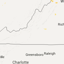
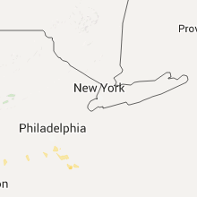
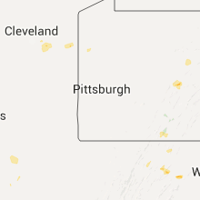
Hail Map for Tuesday, July 14, 2015

Number of Impacted Households on 7/14/2015
0
Impacted by 1" or Larger Hail
0
Impacted by 1.75" or Larger Hail
0
Impacted by 2.5" or Larger Hail
Square Miles of Populated Area Impacted on 7/14/2015
0
Impacted by 1" or Larger Hail
0
Impacted by 1.75" or Larger Hail
0
Impacted by 2.5" or Larger Hail


Cities Most Affected by Hail Storms of 7/14/2015
| Hail Size | Demographics of Zip Codes Affected | ||||||
|---|---|---|---|---|---|---|---|
| City | Count | Average | Largest | Pop Density | House Value | Income | Age |
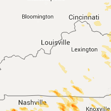
| Cookeville, TN | 3 | 2.42 | 3.00 | 303 | $94k | $30.9k | 35.7 |
| Tompkinsville, KY | 2 | 2.25 | 2.75 | 40 | $63k | $22.9k | 42.6 |
| Franklin, TN | 2 | 1.75 | 1.75 | 668 | $225k | $76.5k | 39.4 |
| Monticello, KY | 2 | 1.75 | 1.75 | 44 | $55k | $20.9k | 40.8 |
| Grimsley, TN | 1 | 1.75 | 1.75 | 90 | $60k | $27.7k | 35.9 |
| Bremen, AL | 1 | 1.75 | 1.75 | 51 | $74k | $32.4k | 41.6 |
| Harriman, TN | 1 | 1.75 | 1.75 | 175 | $76k | $29.2k | 43.5 |
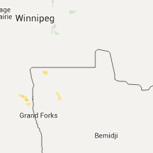
| Balfour, ND | 1 | 1.75 | 1.75 | 1 | $10k | $21.2k | 47.5 |
| Loup City, NE | 1 | 1.75 | 1.75 | 6 | $41k | $26.5k | 49.3 |
| Pleasanton, NE | 1 | 1.75 | 1.75 | 5 | $74k | $40.5k | 41.6 |
Hail and Wind Damage Spotted on 7/14/2015
Filter by Report Type:Hail ReportsWind Reports
States Impacted
North Carolina, Virginia, Kansas, Tennessee, Missouri, Kentucky, Georgia, Ohio, South Carolina, Michigan, Arkansas, Pennsylvania, Florida, New York, West Virginia, Nebraska, Mississippi, North Dakota, Montana, Alabama, Minnesota, Colorado, South Dakota, Arizona, WyomingNorth Carolina
| Local Time | Report Details |
|---|---|
| 8:05 AM EDT | At least one tree blown down this morning in the bat cave and gerton area when the line of storms moved through. this line of storms weakened as it went farther sout in henderson county NC, 46.4 miles NNE of Greenville, SC |
| 8:05 AM EDT | A few trees blown down this morning in the mills river are in henderson county NC, 38.6 miles N of Greenville, SC |
| 10:52 AM EDT | Quarter sized hail reported near Almond, NC, 45.2 miles SSE of Knoxville, TN |
| 12:00 PM EDT | Trees dow in cherokee county NC, 52.7 miles S of Knoxville, TN |
| 12:00 PM EDT | Trees dow in cherokee county NC, 54.5 miles S of Knoxville, TN |
| 5:33 PM EDT | Several trees blown down on fontanna road in swain county NC, 45.2 miles SE of Knoxville, TN |
| 5:36 PM EDT | Numerous trees reported blown down throughouot the county in graham county NC, 44.6 miles S of Knoxville, TN |
| 5:45 PM EDT | Trees dow in cherokee county NC, 54.5 miles S of Knoxville, TN |
| 6:05 PM EDT | County comms reported multiple trees blown down across macon count in macon county NC, 50.3 miles WNW of Greenville, SC |
| 6:20 PM EDT | Several trees snapped and uproote in clay county NC, 61.1 miles WNW of Greenville, SC |
Virginia
| Local Time | Report Details |
|---|---|
| 8:14 AM EDT | Several trees down county wide over the past hour in lee county VA, 50.4 miles W of Bristol, TN |
| 5:59 PM EDT | Tree down 5000 blk wardensville grade in frederick county VA, 79.4 miles E of Elkins, WV |
| 6:37 PM EDT | Quarter sized hail reported near Front Royal, VA, 85.1 miles WSW of Baltimore, MD |
| 6:54 PM EDT | Quarter sized hail reported near Elkton, VA, 78.4 miles ESE of Elkins, WV |
| 7:56 PM EDT | 911 call center reports tree down along uplands road south of covington... v in alleghany county VA, 29.3 miles NNW of Roanoke, VA |
| 7:56 PM EDT | 911 call center reports tree down along dunlap creek road within alleghany county... v in alleghany county VA, 37.8 miles N of Roanoke, VA |
| 8:20 PM EDT | One tree was blown down along holly brook driv in appomattox county VA, 62.3 miles E of Roanoke, VA |
| 8:21 PM EDT | Tree down and wires down in nelson county VA, 62.2 miles WNW of Richmond, VA |
| 8:45 PM EDT | Trees and powerlines down in norton and county wid in city of norton county VA, 32.5 miles NW of Bristol, TN |
| 8:50 PM EDT | Multiple trees were blown down in the saltville are in smyth county VA, 32.4 miles NE of Bristol, TN |
| 8:50 PM EDT | A tree was blown down across grapefield roa in bland county VA, 66.6 miles NE of Bristol, TN |
| 9:10 PM EDT | 911 reports tree down... joppa mill rd in bedford county VA, 23.4 miles E of Roanoke, VA |
| 9:10 PM EDT | 911 reports tree down... moneta rd in bedford county VA, 22.2 miles E of Roanoke, VA |
| 9:10 PM EDT | 911 reports tree down... casey lake view in bedford county VA, 21.8 miles E of Roanoke, VA |
| 9:15 PM EDT | One tree down on hwy 65 north of the manville communit in scott county VA, 27.2 miles WNW of Bristol, TN |
| 9:15 PM EDT | 911 reports tree down... broken bow rd in bedford county VA, 22.2 miles E of Roanoke, VA |
| 9:15 PM EDT | A few trees were blown down around the community of rugb in grayson county VA, 42.9 miles E of Bristol, TN |
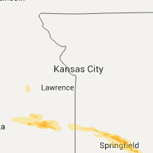
Kansas
| Local Time | Report Details |
|---|---|
| 8:18 AM CDT | Multiple tree limbs up to 8 inches in diameter reported dow in coffey county KS, 37.1 miles NW of Chanute, KS |
| 8:20 AM CDT | Reports of trees and power lines down near yates center and the western portions of the count in woodson county KS, 20.4 miles NW of Chanute, KS |
| 8:41 AM CDT | Estimated 55 to 60 mph wind gust in anderson county KS, 26.2 miles N of Chanute, KS |
| 8:43 AM CDT | Power lines were reported down along with debris in the roadway in allen county KS, 17.3 miles N of Chanute, KS |
| 9:20 AM CDT | Trees reported down on county road 125 between redfield and mapleto in bourbon county KS, 34.7 miles ENE of Chanute, KS |
| 9:24 AM CDT | Large tree blow down at 610 east main in blue moun in linn county KS, 37.1 miles NE of Chanute, KS |
| 9:25 AM CDT | Tree limb four inches in diameter snapped off in blue moun in linn county KS, 37.1 miles NE of Chanute, KS |
| 9:38 AM CDT | Power lines reported down in tow in bourbon county KS, 42 miles ENE of Chanute, KS |
| 1:36 AM CDT | Time estimated from rada in norton county KS, 73.2 miles NNW of Hays, KS |
| 2:01 AM CDT | Measured wind gust from mobile mesonet via the pecan field project in ellis county KS, 1 miles W of Hays, KS |
| 3:06 AM CDT | Storm damage reported in russell county KS, 27.6 miles E of Hays, KS |
| 5:15 AM CDT | Minor tree limb damage. exact diameter unknow in clay county KS, 33 miles WNW of Manhattan, KS |
| 5:45 AM CDT | Quarter sized hail reported near Manhattan, KS, 11.9 miles NW of Manhattan, KS |
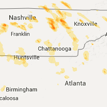
Tennessee
| Local Time | Report Details |
|---|---|
| 11:05 AM EDT | Couple trees dow in monroe county TN, 39.1 miles SW of Knoxville, TN |
| 1:50 PM EDT | Tree down on baileyton r in greene county TN, 44.3 miles SW of Bristol, TN |
| 2:00 PM EDT | Couple trees dow in campbell county TN, 30.6 miles NNW of Knoxville, TN |
| 2:20 PM EDT | Several trees down in the flag pond are in unicoi county TN, 42.9 miles SSW of Bristol, TN |
| 1:52 PM CDT | Golf Ball sized hail reported near Grimsley, TN, 64.8 miles WNW of Knoxville, TN, golfball sized hail reported in grimsley |
| 1:57 PM CDT | Half Dollar sized hail reported near Clarkrange, TN, 59.2 miles WNW of Knoxville, TN, half dollar size hail reported in clarkrange and covering the ground |
| 3:00 PM EDT | Ping Pong Ball sized hail reported near Lancing, TN, 48.8 miles WNW of Knoxville, TN, deer lodge |
| 2:00 PM CDT | Tree down in 2000 block of highway 52 in clay county TN, 73.4 miles ENE of Nashville, TN |
| 2:05 PM CDT | Trees down on highway 31e between gallatin and bethpage in sumner county TN, 27.8 miles NE of Nashville, TN |
| 2:06 PM CDT | Quarter sized hail reported near Jamestown, TN, 65.2 miles WNW of Knoxville, TN, quarter size hail reported downtown jamestown. |
| 3:10 PM EDT | Quarter sized hail reported near Dandridge, TN, 29.1 miles ENE of Knoxville, TN |
| 2:18 PM CDT | Multiple power lines down along with power outages and trees down across overton count in overton county TN, 82.3 miles E of Nashville, TN |
| 3:20 PM EDT | Quarter sized hail reported near Norris, TN, 18.9 miles NNW of Knoxville, TN |
| 3:20 PM EDT | Quarter sized hail reported near Rockwood, TN, 42.6 miles W of Knoxville, TN |
| 2:21 PM CDT | Quarter sized hail reported near Franklin, TN, 16.8 miles SSW of Nashville, TN, quarter size hail reported at old natchez trace country club |
| 2:21 PM CDT | Golf Ball sized hail reported near Franklin, TN, 16.8 miles SSW of Nashville, TN, golf ball sized hail reported at old natchez trace country club |
| 2:28 PM CDT | Quarter sized hail reported near Nashville, TN, 9.2 miles SW of Nashville, TN, quarter plus sized hail reported at percy warner park |
| 2:30 PM CDT | Quarter sized hail reported near Cookeville, TN, 70.9 miles E of Nashville, TN, quarter sized hail reported near cookeville. |
| 2:31 PM CDT | Golf Ball sized hail reported near Franklin, TN, 15.6 miles SSW of Nashville, TN, golf ball sized hail reported by a tv met near grassland |
| 2:37 PM CDT | Trees reports down around the town of dickson in dickson county TN, 35.2 miles WSW of Nashville, TN |
| 2:45 PM CDT | Golf Ball sized hail reported near Cookeville, TN, 74.3 miles E of Nashville, TN, photos from facebook show golf ball size hail in algood |
| 2:45 PM CDT | Quarter sized hail reported near Monterey, TN, 74.8 miles W of Knoxville, TN, quarter size hail reported in monterey |
| 2:50 PM CDT | Tennis Ball sized hail reported near Cookeville, TN, 70.9 miles E of Nashville, TN, facebook photo of tennis ball size hail in cookeville |
| 3:50 PM EDT | Golf Ball sized hail reported near Harriman, TN, 35.9 miles W of Knoxville, TN |
| 3:50 PM EDT | Tree down on babelay r in knox county TN, 1.8 miles WNW of Knoxville, TN |
| 2:50 PM CDT | Tea Cup sized hail reported near Cookeville, TN, 70.9 miles E of Nashville, TN, wkrn-tv photos show hail ranging from golf ball to large apple size fell in cookeville |
| 2:51 PM CDT | Trees uprooted and power lines down near lebanon near coles ferry road and berea church road and academy road in wilson county TN, 24.3 miles E of Nashville, TN |
| 2:53 PM CDT | Several large trees uprooted at turner farm in williamson county TN, 10.9 miles S of Nashville, TN |
| 2:55 PM CDT | Numerous trees and power lines down across the city including on heathrow blvd...stewart lane...and meadowlark lan in williamson county TN, 11.6 miles S of Nashville, TN |
| 2:56 PM CDT | Quarter sized hail reported near Nashville, TN, 10.4 miles SW of Nashville, TN, one inch plus hail reported in riverwalk subdivision in bellevue |
| 2:57 PM CDT | Trees and power lines down around the rocky valley road area in wilson county TN, 25.7 miles E of Nashville, TN |
| 3:00 PM CDT | Power outages with dime size hail in hickman county TN, 44.2 miles WSW of Nashville, TN |
| 3:00 PM CDT | Trees down in grant community in smith county TN, 39 miles E of Nashville, TN |
| 3:00 PM CDT | Multiple large trees down with shed and barn damaged around the hawkins crawford road and structural damage to home near prosperity drive in putnam county TN, 67 miles E of Nashville, TN |
| 3:03 PM CDT | Widespread wind damage occurred across southwest nashville. trees were blown down and blocked all westbound lanes of west end avenue near i-440. a tree was blown down a in davidson county TN, 4.9 miles SW of Nashville, TN |
| 3:04 PM CDT | Tree down in the 300 block of bell meade blvd in davidson county TN, 6.1 miles SW of Nashville, TN |
| 3:05 PM CDT | Power lines and trees down along double log cabin road in wilson county TN, 20.8 miles ENE of Nashville, TN |
| 3:05 PM CDT | 3 trees blown down with one on a house at stones river road at lavergne lane in rutherford county TN, 15.9 miles SE of Nashville, TN |
| 3:07 PM CDT | Three to four homes damaged by uprooted large trees in the belle meade and forest hills area in davidson county TN, 7.1 miles SSW of Nashville, TN |
| 3:07 PM CDT | Numerous trees and power lines down along the west end corridor in midtown nashville...including one tree on vanderbilt campu in davidson county TN, 3 miles SW of Nashville, TN |
| 3:08 PM CDT | 2 homes damaged by fallen trees on marengo lane in davidson county TN, 4 miles S of Nashville, TN |
| 3:10 PM CDT | Tree down on a church on 9th avenue south in davidson county TN, 2.6 miles S of Nashville, TN |
| 3:18 PM CDT | Trees and power lines down at the woodmont blvd and valley brook road and along alabama ave in west nashville in davidson county TN, 4.3 miles SW of Nashville, TN |
| 3:18 PM CDT | Trees and pwer lines down at the woodmont blvd and valley brook road and along alabama ave in west nashville in davidson county TN, 4.3 miles SW of Nashville, TN |
| 3:21 PM CDT | Three trees and two powerlines down among several street in carroll county TN, 10.5 miles SE of Mc Kenzie, TN |
| 4:25 PM EDT | Trees down countywid in roane county TN, 35.9 miles W of Knoxville, TN |
| 3:25 PM CDT | Trees down on adcock cemetery road in de kalb county TN, 58.2 miles ESE of Nashville, TN |
| 3:25 PM CDT | Measured on home weather station in de kalb county TN, 58.2 miles ESE of Nashville, TN |
| 3:30 PM CDT | Numerous trees down in the jefferson road area in de kalb county TN, 62.3 miles ESE of Nashville, TN |
| 3:34 PM CDT | Tree down in lake forrest estates area in rutherford county TN, 16.4 miles SE of Nashville, TN |
| 3:45 PM CDT | Widespread damage across tipton county with a few buildings in atoka receiving roof and structural damag in tipton county TN, 26 miles NE of Memphis, TN |
| 3:45 PM CDT | Storm damage reported in tipton county TN, 26 miles NE of Memphis, TN |
| 4:45 PM EDT | Trees down along wears valley r in blount county TN, 23 miles SSE of Knoxville, TN |
| 3:50 PM CDT | Several trees down across tipton county. hardest hit areas are in gilt edge...mumford and atok in tipton county TN, 29 miles NNE of Memphis, TN |
| 3:50 PM CDT | Power lines down on highway 5 in tipton county TN, 35.6 miles NE of Memphis, TN |
| 4:50 PM EDT | 1 tree dow in rhea county TN, 53.8 miles WSW of Knoxville, TN |
| 4:50 PM EDT | Trees down in the northern meigs count in meigs county TN, 46.6 miles WSW of Knoxville, TN |
| 3:50 PM CDT | Tree down in covingto in tipton county TN, 36.7 miles NE of Memphis, TN |
| 3:54 PM CDT | Tree down on residence along lavergne lane in davidson county TN, 14.6 miles SE of Nashville, TN |
| 3:55 PM CDT | Traffic signal down across the road at hwys 51 and 38 in shelby county TN, 15.3 miles NE of Memphis, TN |
| 4:00 PM CDT | Tree down on car on mynders av in shelby county TN, 4.1 miles ESE of Memphis, TN |
| 4:00 PM CDT | Roof blown off barn at west green hill road and campbell road in warren county TN, 56.2 miles ESE of Nashville, TN |
| 4:00 PM CDT | Tree down on memphis/arlington roa in shelby county TN, 12.8 miles ENE of Memphis, TN |
| 4:00 PM CDT | Roof collapse at armory of tn national guar in shelby county TN, 15.3 miles NE of Memphis, TN |
| 5:00 PM EDT | Tree blown off of home on southgate roa in monroe county TN, 39.1 miles SW of Knoxville, TN |
| 4:00 PM CDT | Reports of trees down along old nashville hwy shelbyville road and short mountain at west green hill road in warren county TN, 56.5 miles ESE of Nashville, TN |
| 4:00 PM CDT | Several trees down across dyer county with power outage in dyer county TN, 48.6 miles W of Mc Kenzie, TN |
| 4:00 PM CDT | Several trees across roadways in lauderdale count in lauderdale county TN, 50.7 miles NE of Memphis, TN |
| 4:00 PM CDT | Several trees down across decatur count in decatur county TN, 40.1 miles SE of Mc Kenzie, TN |
| 4:00 PM CDT | Some trees down across the county with power outage in gibson county TN, 26.1 miles WSW of Mc Kenzie, TN |
| 4:00 PM CDT | Several trees down in haywood count in haywood county TN, 45.9 miles SW of Mc Kenzie, TN |
| 4:01 PM CDT | Trees down on power lines blocking road on will thompson road in white county TN, 63.1 miles NNW of Chattanooga, TN |
| 4:05 PM CDT | Large tree fell on a car near highland av in shelby county TN, 4.1 miles ESE of Memphis, TN |
| 4:05 PM CDT | Tree on powerline at echol in shelby county TN, 4.1 miles ESE of Memphis, TN |
| 4:07 PM CDT | Numerous reports of multiple trees down in the west end of white county in white county TN, 66.6 miles NNW of Chattanooga, TN |
| 4:11 PM CDT | Storm damage reported in madison county TN, 26.6 miles SSW of Mc Kenzie, TN |
| 4:15 PM CDT | Tree down near neshoba roa in shelby county TN, 15.2 miles ESE of Memphis, TN |
| 4:15 PM CDT | Tree down on dogwoo in shelby county TN, 15.2 miles ESE of Memphis, TN |
| 5:15 PM EDT | Trees down countywid in loudon county TN, 22.5 miles WSW of Knoxville, TN |
| 5:15 PM EDT | Numerous trees dow in mcminn county TN, 49.1 miles SW of Knoxville, TN |
| 4:20 PM CDT | Several trees down around the county...large tree down on a house in henderson county TN, 34.1 miles SSE of Mc Kenzie, TN |
| 4:21 PM CDT | Reports of trees down along old nashville hwy shelbyville road and short mountain at west green hill road in warren county TN, 56.5 miles ESE of Nashville, TN |
| 4:25 PM CDT | Spotter measured 65 mph wind gust near collierville elementar in shelby county TN, 21.8 miles ESE of Memphis, TN |
| 4:25 PM CDT | Large tree uprooted...several other large limbs off of large trees near broadway n of bartlet in shelby county TN, 12.8 miles ENE of Memphis, TN |
| 4:30 PM CDT | Tree down on highlan in shelby county TN, 1.4 miles S of Memphis, TN |
| 4:30 PM CDT | Tree down on a house on springdale stree in shelby county TN, 4.1 miles ESE of Memphis, TN |
| 4:30 PM CDT | Tree down on robin hood lan in shelby county TN, 4.1 miles ESE of Memphis, TN |
| 4:40 PM CDT | Power lines down in whitevill in hardeman county TN, 52.3 miles ENE of Memphis, TN |
| 4:45 PM CDT | Some trees down with scattered power outage in fayette county TN, 40 miles E of Memphis, TN |
| 4:50 PM CDT | Several trees down on automobile in sequatchie county TN, 22.8 miles NNW of Chattanooga, TN |
| 4:55 PM CDT | Several trees down across chester count in chester county TN, 48.3 miles S of Mc Kenzie, TN |
| 4:55 PM CDT | Trees dow in marion county TN, 17 miles NNW of Chattanooga, TN |
| 4:55 PM CDT | Trees and powerlines down on hwy 223 and womack lan in madison county TN, 43.8 miles SW of Mc Kenzie, TN |
| 4:58 PM CDT | Tree across hwy 18 and lowery roa in madison county TN, 43.8 miles SW of Mc Kenzie, TN |
| 6:00 PM EDT | Several trees dow in polk county TN, 52.1 miles E of Chattanooga, TN |
| 5:00 PM CDT | Large tree down at riddle road and highway 55 intersection in coffee county TN, 52.4 miles NW of Chattanooga, TN |
| 5:00 PM CDT | Trees dow in marion county TN, 15.9 miles NW of Chattanooga, TN |
| 5:00 PM CDT | A few trees downed by thunderstorm wind in moore county TN, 62 miles WNW of Chattanooga, TN |
| 5:05 PM CDT | Several trees down across hardeman count in hardeman county TN, 59.8 miles E of Memphis, TN |
| 5:05 PM CDT | North wood drive memphis blocked by a tree which fell onto an su in shelby county TN, 1.4 miles S of Memphis, TN |
| 5:05 PM CDT | Trees and power lines dow in marion county TN, 13.3 miles NW of Chattanooga, TN |
| 5:15 PM CDT | Several trees down across hardin county with scattered power outage in hardin county TN, 43.2 miles NW of Florence, AL |
| 5:15 PM CDT | Numerous trees down on houses in the limbo road area of hillsboro in coffee county TN, 47.7 miles WNW of Chattanooga, TN |
| 5:15 PM CDT | Several trees down across the county with power outage in mcnairy county TN, 57.8 miles WNW of Florence, AL |
| 5:15 PM CDT | Trees snapped and uprooted on love lane road in hillsboro in coffee county TN, 47.3 miles WNW of Chattanooga, TN |
| 6:20 PM EDT | Trees down countywid in hamilton county TN, 3.2 miles ENE of Chattanooga, TN |
| 5:33 PM CDT | Trees down on bealer road and dugout road. large tree limb down on winfall roa in lawrence county TN, 32.9 miles NNE of Florence, AL |
| 5:45 PM CDT | Spotter estimated 60 mph wind gust in southern wayne county. report relayed by emergency manage in wayne county TN, 21.6 miles NNW of Florence, AL |
| 6:45 PM EDT | Few trees dow in bradley county TN, 26.5 miles ENE of Chattanooga, TN |
Missouri
| Local Time | Report Details |
|---|---|
| 10:49 AM CDT | Roof damage to a barn. picture relayed on social media from local tv statio in polk county MO, 32.8 miles NNW of Springfield, MO |
| 10:50 AM CDT | Two inch diameter limbs dow in cedar county MO, 37.9 miles NW of Springfield, MO |
| 11:03 AM CDT | Tree damage reported near the intersections of county roads s170 and e53 in polk county MO, 18.8 miles N of Springfield, MO |
| 11:05 AM CDT | Power lines and 5 inch diameter limb down along buffalo road in tow in polk county MO, 28.4 miles NNW of Springfield, MO |
| 11:10 AM CDT | Nickle hail also reported with the wind gus in polk county MO, 24.7 miles NNW of Springfield, MO |
| 11:10 AM CDT | Tree down at teh intersection of farmer and cherry streets in town. time estimated from rada in greene county MO, 10.3 miles NW of Springfield, MO |
| 11:25 AM CDT | 10 inch diameter tree branch snapped 1 mile south of fair grove along highway 125. time estimated based on rada in greene county MO, 13.6 miles NE of Springfield, MO |
| 11:31 AM CDT | Quarter sized hail reported near Bolivar, MO, 21.1 miles N of Springfield, MO |
| 11:31 AM CDT | A few trees reported down near farm road 34 and highway 1 in greene county MO, 12.1 miles NNW of Springfield, MO |
| 11:41 AM CDT | Tree limbs down and a large metal swing set blown ove in webster county MO, 22.6 miles NE of Springfield, MO |
| 11:41 AM CDT | North pitts st had tree uprooted. electric out along with stop lights. also trees down on washington stree in webster county MO, 22.9 miles ENE of Springfield, MO |
| 11:41 AM CDT | Over 100 trees uprooted or snapped off. power poles snapped halfway up. extensive power lines down. dozens of trees on homes. some shingle damage and roof peelings. sev in webster county MO, 21.5 miles NE of Springfield, MO |
| 11:43 AM CDT | Road signs and trees dow in greene county MO, 14.1 miles NNE of Springfield, MO |
| 11:45 AM CDT | Limbs to 6 inches in diameter down on banning street in tow in webster county MO, 22.9 miles ENE of Springfield, MO |
| 11:51 AM CDT | Numerous large trees down. time based on radar estimat in webster county MO, 28.3 miles ENE of Springfield, MO |
| 11:51 AM CDT | Trailer park on plank school road had some mobile homes that slid off of their pier in webster county MO, 24.8 miles ENE of Springfield, MO |
| 11:58 AM CDT | Small 1 inch limbs down from hwy 123 to fr 42 and from fr 91 to fr 79 in northern greene county. time estimated based on rada in greene county MO, 10.3 miles NW of Springfield, MO |
| 12:00 PM CDT | Large 8 inch diameterr limb down on highway 12 in greene county MO, 12.5 miles NE of Springfield, MO |
| 12:15 PM CDT | Mshp reports part of a roof blown into traffic near the 107 mile marker on i-44. traffic blocke in webster county MO, 26.9 miles ENE of Springfield, MO |
| 12:15 PM CDT | Damage to a barn. large limbs dow in wright county MO, 52 miles E of Springfield, MO |
| 12:42 PM CDT | Storm damage reported in texas county MO, 47.3 miles SW of Salem, MO |
| 12:58 PM CDT | Trees down across road on old rolla roa in howell county MO, 49.4 miles SSW of Salem, MO |
| 1:08 PM CDT | Trees and limbs down up to eight inches in diamete in howell county MO, 53.1 miles SSW of Salem, MO |
| 1:40 PM CDT | Report of powerlines and trees down. most main roads are blocked by trees or powerlines. also received twitter public report of an estimated 60-70 mph win in oregon county MO, 65.7 miles S of Salem, MO |
| 3:28 PM CDT | Trees down in cardwel in dunklin county MO, 63.5 miles NNW of Memphis, TN |
Kentucky
| Local Time | Report Details |
|---|---|
| 12:00 PM EDT | Golf Ball sized hail reported near Monticello, KY, 76.4 miles SW of Irvine, KY |
| 12:01 PM EDT | Golf Ball sized hail reported near Monticello, KY, 76.4 miles SW of Irvine, KY, hail falling at dispatch center. |
| 1:37 PM CDT | Golf Ball sized hail reported near Tompkinsville, KY, 70.9 miles ENE of Nashville, TN, also reported high winds and heavy rain. |
| 1:38 PM CDT | Baseball sized hail reported near Tompkinsville, KY, 70.9 miles ENE of Nashville, TN |
| 1:51 PM CDT | Power lines dow in cumberland county KY, 81.2 miles SSE of Louisville, KY |
| 3:50 PM EDT | Large tree on a car on 4th street in newport. time of event estimated from rada in campbell county KY, 1.4 miles SE of Cincinnati, OH |
| 4:58 PM EDT | Multiple trees downed on jonesville road. time of event estimated from rada in owen county KY, 36.1 miles SSW of Cincinnati, OH |
| 5:20 PM EDT | Several trees dow in greenup county KY, 66.3 miles WNW of Charleston, WV |
| 5:32 PM EDT | Large tree limbs were blown dow in fleming county KY, 50.7 miles N of Irvine, KY |
| 5:35 PM EDT | Several trees and power lines dow in boyd county KY, 54.9 miles W of Charleston, WV |
| 5:37 PM EDT | *** 4 inj *** wind damage to mobile home on 2512 cherry grove road near mount carmel...mobile home was moved 60 feet by wind...hitting a garage/barn. 4 people were insi in fleming county KY, 54.9 miles NNE of Irvine, KY |
| 5:48 PM EDT | Several trees and power lines dow in carter county KY, 70.7 miles W of Charleston, WV |
| 6:02 PM EDT | Multiple areas of wind damage on 60 e in morehead. multiple trees down...underpinning blown out from multiple trailers...damage to cars...tops of trees blown off at lea in rowan county KY, 44.7 miles NE of Irvine, KY |
| 6:05 PM EDT | Trees and power lines are down near the state police post... causing some power outages nearb in rowan county KY, 44.7 miles NE of Irvine, KY |
| 6:05 PM EDT | Trees were reported to have been blown dow in bath county KY, 34.9 miles NNE of Irvine, KY |
| 6:20 PM EDT | Several trees and power lines dow in lawrence county KY, 54.8 miles WSW of Charleston, WV |
| 6:20 PM EDT | Trees were blown dow in bath county KY, 29.6 miles NNE of Irvine, KY |
| 6:20 PM EDT | Trees were blown dow in bath county KY, 37.6 miles NE of Irvine, KY |
| 6:25 PM EDT | Trees and power lines are down near the state police post... causing some power outages nearb in rowan county KY, 44.7 miles NE of Irvine, KY |
| 6:35 PM EDT | Trees dow in lawrence county KY, 65.6 miles ENE of Irvine, KY |
| 6:35 PM EDT | A tree was blown dow in menifee county KY, 26 miles NE of Irvine, KY |
| 6:37 PM EDT | Wind damage to mobile home on 2512 cherry grove road near mount carmel...mobile home was moved 60 feet by wind...hitting a garage/barn. 4 people were inside and injured in fleming county KY, 54.9 miles NNE of Irvine, KY |
| 6:40 PM EDT | A tree was blown down onto a hom in menifee county KY, 26.9 miles ENE of Irvine, KY |
| 6:49 PM EDT | Large limbs and parts of trees on hwy 101 in morgan county KY, 32.1 miles ENE of Irvine, KY |
| 6:53 PM EDT | Video of tree falling onto 8th street in paintsville in johnson county KY, 64.3 miles E of Irvine, KY |
| 7:05 PM EDT | Tree fell on hous in morgan county KY, 38.5 miles E of Irvine, KY |
| 7:10 PM EDT | Trees were blown dow in breathitt county KY, 41.5 miles E of Irvine, KY |
| 7:10 PM EDT | Numerous trees and powerlines dow in floyd county KY, 67.2 miles E of Irvine, KY |
| 7:20 PM EDT | Trees were blown dow in breathitt county KY, 31.3 miles E of Irvine, KY |
| 7:21 PM EDT | Hwy 89 road closed due to tree blocking both lane in estill county KY, 9 miles N of Irvine, KY |
| 7:22 PM EDT | 10 inch diameter tree across roadwa in jefferson county KY, 16 miles N of Louisville, KY |
| 7:25 PM EDT | Trees were blown down on ky highway 47 in breathitt county KY, 38.5 miles ESE of Irvine, KY |
| 7:25 PM EDT | Tree dow in jefferson county KY, 14.4 miles NNW of Louisville, KY |
| 7:28 PM EDT | Trees and power pole dow in jefferson county KY, 18.1 miles N of Louisville, KY |
| 7:30 PM EDT | Trees were blown dow in pike county KY, 63.3 miles NNW of Bristol, TN |
| 7:30 PM EDT | A tree was blown dow in lee county KY, 16.7 miles ESE of Irvine, KY |
| 7:34 PM EDT | Trees and power lines dow in nelson county KY, 14.6 miles S of Louisville, KY |
| 7:35 PM EDT | A tree was blown down on curt roa in breathitt county KY, 34.9 miles ESE of Irvine, KY |
| 7:40 PM EDT | Large tree limbs dow in lee county KY, 16.7 miles SE of Irvine, KY |
| 7:40 PM EDT | A tree was blown dow in perry county KY, 44.7 miles ESE of Irvine, KY |
| 7:42 PM EDT | Four trees dow in jefferson county KY, 17.1 miles NNE of Louisville, KY |
| 7:45 PM EDT | Trees down across prestonsburg and floyd county...including mays branch...corn fork...and a tree which fell on and damaged a fire truck on jenny wiley roa in floyd county KY, 66.1 miles E of Irvine, KY |
| 7:47 PM EDT | Trees and power lines dow in marion county KY, 38.5 miles SE of Louisville, KY |
| 7:48 PM EDT | Some power lines dow in marion county KY, 38.5 miles SE of Louisville, KY |
| 7:50 PM EDT | A tree was blown down onto ky highway 899 in knott county KY, 62.3 miles NW of Bristol, TN |
| 7:50 PM EDT | A tree was blown down on houston roa in breathitt county KY, 31.2 miles SE of Irvine, KY |
| 7:53 PM EDT | A tree was blown down onto riley br r in breathitt county KY, 40 miles ESE of Irvine, KY |
| 7:55 PM EDT | A tree was blown down onto the roadwa in knott county KY, 56 miles ESE of Irvine, KY |
| 7:55 PM EDT | A tree was blown dow in perry county KY, 52.1 miles ESE of Irvine, KY |
| 8:00 PM EDT | A tree was blown down onto yellow ck r in knott county KY, 56.5 miles ESE of Irvine, KY |
| 8:00 PM EDT | A tree was blown dow in knott county KY, 63 miles NW of Bristol, TN |
| 8:00 PM EDT | A tree was blown dow in perry county KY, 52.7 miles SE of Irvine, KY |
| 8:08 PM EDT | A tree was blown dow in knott county KY, 60.2 miles NW of Bristol, TN |
| 8:10 PM EDT | A tree was blown down onto a hous in letcher county KY, 55.8 miles NW of Bristol, TN |
| 7:10 PM CDT | Two trees reported dow in grayson county KY, 45.5 miles SW of Louisville, KY |
| 8:12 PM EDT | A tree was blown dow in letcher county KY, 58.3 miles NW of Bristol, TN |
| 8:15 PM EDT | Trees were blown down onto pert ck r in letcher county KY, 48.2 miles NW of Bristol, TN |
| 8:15 PM EDT | Trees were blown down onto hampton br r in letcher county KY, 51.4 miles NW of Bristol, TN |
| 8:15 PM EDT | A tree was blown dow in letcher county KY, 56.2 miles NW of Bristol, TN |
| 8:15 PM EDT | Powerlines were blown dow in letcher county KY, 56.2 miles NW of Bristol, TN |
| 8:20 PM EDT | Two trees dow in casey county KY, 59.6 miles WSW of Irvine, KY |
| 8:21 PM EDT | Trees were blown down near east bernstad in laurel county KY, 36.1 miles SSW of Irvine, KY |
| 8:38 PM EDT | Powerlines were blown dow in leslie county KY, 49.9 miles SE of Irvine, KY |
| 8:38 PM EDT | Trees were blown dow in leslie county KY, 53.2 miles SSE of Irvine, KY |
| 8:39 PM EDT | Several large trees dow in laurel county KY, 44.1 miles S of Irvine, KY |
| 8:50 PM EDT | Trees were reported to have been blown down throughout the count in pulaski county KY, 55.2 miles SW of Irvine, KY |
| 8:55 PM EDT | Trees were reported to have been blown down in barbourville and throughout the count in knox county KY, 57.5 miles S of Irvine, KY |
| 9:00 PM EDT | A tree was blown dow in wayne county KY, 76.3 miles SW of Irvine, KY |
| 10:40 PM CDT | Two trees dow in allen county KY, 51.5 miles NE of Nashville, TN |
Georgia
| Local Time | Report Details |
|---|---|
| 12:20 PM EDT | Few trees down in towns county GA, 66.4 miles W of Greenville, SC |
| 1:44 PM EDT | Trees down along hwy 17...one on a transforme in hart county GA, 41.9 miles SW of Greenville, SC |
| 1:50 PM EDT | Quarter sized hail reported near Dahlonega, GA, 64.5 miles NNE of Atlanta, GA |
| 3:42 PM EDT | Large tree down at us 1 north and east river rd in appling county GA, 37.5 miles NE of Douglas, GA |
| 3:43 PM EDT | Large trees down and power lines down along hwy 341 in jeff davis county GA, 28.8 miles NNE of Douglas, GA |
| 3:55 PM EDT | The law enforcement reported trees down in the alma area. the time given was based on rada in bacon county GA, 21.9 miles E of Douglas, GA |
| 4:14 PM EDT | Power line down near toombs and west hill street in lowndes county GA, 53.1 miles SSW of Douglas, GA |
| 4:35 PM EDT | Storm damage reported in camden county GA, 43.5 miles N of Jacksonville, FL |
| 4:35 PM EDT | Large trees down and power lines down along hwy 341 in jeff davis county GA, 28.8 miles NNE of Douglas, GA |
| 5:15 PM EDT | Tree down on teeterville highway in lanier county GA, 32.2 miles SSW of Douglas, GA |
| 5:30 PM EDT | The law enforcement received reports of trees down in the nahunta are in brantley county GA, 55.3 miles ESE of Douglas, GA |
| 6:17 PM EDT | Multiple large trees down. time estimated from rada in towns county GA, 58.5 miles W of Greenville, SC |
| 6:30 PM EDT | 911 call center has received multiple reports of trees down county-wid in fannin county GA, 57.6 miles ESE of Chattanooga, TN |
| 6:32 PM EDT | Numerous trees down between tiger and lake burto in rabun county GA, 51.2 miles W of Greenville, SC |
| 6:35 PM EDT | Trees down all over rabun county with a few down in the city of clayto in rabun county GA, 45.6 miles W of Greenville, SC |
| 6:40 PM EDT | Multiple reports of trees and powerlines down along boardtown road near whitepath roa in gilmer county GA, 53.1 miles ESE of Chattanooga, TN |
| 6:50 PM EDT | Trees and power lines down all over habersham count in habersham county GA, 54.5 miles WSW of Greenville, SC |
| 6:55 PM EDT | Trees were downed on seep springs r in whitfield county GA, 22.7 miles SE of Chattanooga, TN |
| 7:00 PM EDT | A tree was downed onto power lines on riverbend road in dalto in whitfield county GA, 30.3 miles SE of Chattanooga, TN |
| 7:00 PM EDT | Trees down all over stephens count in stephens county GA, 44.5 miles WSW of Greenville, SC |
| 7:15 PM EDT | 1 power line down in worth county in worth county GA, 49 miles W of Douglas, GA |
| 7:20 PM EDT | Emergency manager reported multiple trees down just to the west of homer along carson segars road near highway 32 in banks county GA, 61.8 miles SW of Greenville, SC |
| 7:28 PM EDT | A few trees down mainly along poplar springs roa in franklin county GA, 39.6 miles SW of Greenville, SC |
| 7:29 PM EDT | Tree down at intersection of airport road and lothridge roa in white county GA, 65.1 miles WSW of Greenville, SC |
| 7:32 PM EDT | Many trees down all across hart county and at least one power line down in hartwel in hart county GA, 38.1 miles SSW of Greenville, SC |
| 7:35 PM EDT | 911 call center has received reports of numerous trees down county-wid in walker county GA, 23.5 miles SSW of Chattanooga, TN |
| 7:38 PM EDT | A few trees down in far eastern franklin county in vicinity of franklin spring in franklin county GA, 49.2 miles SW of Greenville, SC |
| 7:40 PM EDT | Several trees blown down including on meyer farm rd...onnie colquitt rd...and lexington-carlton rd in oglethorpe county GA, 69 miles E of Atlanta, GA |
| 7:40 PM EDT | Numerous trees reported down...especially in the southern end of the count in pickens county GA, 47 miles N of Atlanta, GA |
| 7:46 PM EDT | Report of tree down across roadway at little refuge road and hwy 14 in cherokee county GA, 42.1 miles NNW of Atlanta, GA |
| 7:50 PM EDT | Several trees down. power outages reported in cherokee county GA, 40.8 miles N of Atlanta, GA |
| 7:59 PM EDT | Emergency manager reported 30-40 trees down county-wide. based on radar velocity data...estimated hardest hit area between trion and subligna shortly before 8pm. one of in chattooga county GA, 34.9 miles S of Chattanooga, TN |
| 8:00 PM EDT | Trees down in elbert count in elbert county GA, 51.9 miles SSW of Greenville, SC |
| 8:01 PM EDT | Quarter sized hail in summervill in chattooga county GA, 39.1 miles S of Chattanooga, TN |
| 8:01 PM EDT | Quarter sized hail reported near Summerville, GA, 39.1 miles S of Chattanooga, TN, quarter sized hail in summerville. |
| 8:10 PM EDT | Trees and powerlines down at intersection of post road and drew road. additional reports of trees down along post road near bentley roa in forsyth county GA, 33.3 miles NNE of Atlanta, GA |
| 8:15 PM EDT | Numerous trees down throughout cherokee county. tree on house off wilkie road. trees down on union hill road...land rd...and birmingham hwy in cherokee county GA, 31.1 miles NNE of Atlanta, GA |
| 8:15 PM EDT | Emergency manager reported numerous trees down in the vicinity of martha berry highway near rom in floyd county GA, 54.6 miles S of Chattanooga, TN |
| 8:15 PM EDT | Several trees were downed across the county...including in calhou in gordon county GA, 42.9 miles SSE of Chattanooga, TN |
| 8:18 PM EDT | Large tree on a house off trail side way. significant damage to the hom in forsyth county GA, 44.2 miles NNE of Atlanta, GA |
| 8:29 PM EDT | 911 call center rceived report of a tree down on jackson trail road just east of braselto in jackson county GA, 44 miles NE of Atlanta, GA |
| 8:29 PM EDT | Powerlines down on fields landing drive in cherokee county GA, 33.3 miles NNW of Atlanta, GA |
| 8:30 PM EDT | A powerline was downed at a shopping center on atlanta highwa in clarke county GA, 55.2 miles ENE of Atlanta, GA |
| 8:30 PM EDT | 911 call center received numerous reports of downed trees and powerlines across a majority of the county but particularly across powder springs and kennesa in cobb county GA, 18.3 miles WNW of Atlanta, GA |
| 8:35 PM EDT | 911 call center has received numerous reports of trees down county-wide. based on radar velocity data...estimated area with greatest impact looks to be around cartersvi in bartow county GA, 37.4 miles NW of Atlanta, GA |
| 8:37 PM EDT | A tree was downed onto a power line on epps bridge parkwa in oconee county GA, 54.7 miles ENE of Atlanta, GA |
| 8:40 PM EDT | Several trees blown down including on meyer farm rd...onnie colquitt rd...and lexington-carlton rd in oglethorpe county GA, 69.6 miles SSW of Greenville, SC |
| 8:45 PM EDT | Emergency manager reported 20 trees either downed or snapped just southwest of kennesaw. damage to one home was also reported on stilesboro roa in cobb county GA, 22.9 miles NW of Atlanta, GA |
| 8:46 PM EDT | Emergency manager reported 1 large tree down on merchants drive near dallas that is blocking the road. numerous powerlines have also been downe in paulding county GA, 28.4 miles WNW of Atlanta, GA |
| 8:50 PM EDT | Tree on a house off wiley bridge roa in cherokee county GA, 23.7 miles N of Atlanta, GA |
| 9:15 PM EDT | Several trees down in roswell. tree on a house on highland colony drive in fulton county GA, 18.8 miles N of Atlanta, GA |
| 9:18 PM EDT | Trees and powerlines down on west conway drive northwest in fulton county GA, 7.9 miles NNW of Atlanta, GA |
| 9:20 PM EDT | Tree down on car with person trapped...montgomery ferry and monroe d in fulton county GA, 3.8 miles NNE of Atlanta, GA |
| 9:24 PM EDT | A tree was blown onto a house on argonne avenu in fulton county GA, 2.3 miles NNE of Atlanta, GA |
| 9:25 PM EDT | Around 20 instances of trees and power lines down throughout dekalb count in dekalb county GA, 5.9 miles E of Atlanta, GA |
Ohio
| Local Time | Report Details |
|---|---|
| 12:25 PM EDT | One tree down on spencer circle and another on brown rd in cridersville area. time estimated by rada in auglaize county OH, 57.8 miles ESE of Fort Wayne, IN |
| 12:57 PM EDT | Two foot diameter limb downed into a house. power lines also brought down in the are in seneca county OH, 80.4 miles N of Columbus, OH |
| 1:20 PM EDT | Several trees down on sr 87- road is closed in russell tw in geauga county OH, 19.4 miles ESE of Cleveland, OH |
| 1:30 PM EDT | Several trees down in southern marion county off of state route 4 and prospect-upper sandusky road sout in marion county OH, 35.1 miles NNW of Columbus, OH |
| 1:42 PM EDT | 1 tree reported down at hanover road and horseshoe road in delaware county OH, 26.8 miles N of Columbus, OH |
| 1:48 PM EDT | Quarter sized hail reported near Lodi, OH, 36.7 miles SSW of Cleveland, OH, summit county skywarn member reported 1 inch hail in lodi. winds picking up at location. |
| 1:51 PM EDT | Quarter sized hail reported near Urbana, OH, 42.6 miles W of Columbus, OH |
| 2:16 PM EDT | Tree reported down on a home on new gambier rd. numerous trees and powerlines down across southern portion of count in knox county OH, 39 miles NE of Columbus, OH |
| 2:18 PM EDT | Large pine trees uprooted near blendon park condominiums. time estimated by rada in franklin county OH, 10.6 miles NE of Columbus, OH |
| 2:21 PM EDT | Several trees down in clinton off van buren roa in summit county OH, 39.8 miles S of Cleveland, OH |
| 2:23 PM EDT | Several large tree limbs down across area. time estimated by rada in franklin county OH, 9.8 miles ENE of Columbus, OH |
| 2:36 PM EDT | Several trees and limbs down in fairborn area. time estimated by rada in greene county OH, 52.9 miles NNE of Cincinnati, OH |
| 2:46 PM EDT | Large tree split in half. time estimated by rada in greene county OH, 53.1 miles NNE of Cincinnati, OH |
| 2:48 PM EDT | Several trees down and tops of trees cut off. limbs down across area. time estimated by rada in greene county OH, 51.6 miles NNE of Cincinnati, OH |
| 2:51 PM EDT | Large tree limb down in driveway on ludlow rd. time estimated by rada in greene county OH, 52.8 miles NNE of Cincinnati, OH |
| 2:53 PM EDT | Numerous large trees down across colorado and carolina avenues... including tree on roof of home. time estimated by rada in greene county OH, 48.3 miles NE of Cincinnati, OH |
| 2:53 PM EDT | 1 tree down at ledbetter road and route 380 in greene county OH, 49.6 miles NE of Cincinnati, OH |
| 2:53 PM EDT | Tree reported down on house. time estimated by rada in montgomery county OH, 40.5 miles NNE of Cincinnati, OH |
| 2:53 PM EDT | Several trees down on country club drive in greene county OH, 51.8 miles WSW of Columbus, OH |
| 2:53 PM EDT | Several trees and large tree limbs down on shannon ln near xenia. time estimated by rada in greene county OH, 47.4 miles NE of Cincinnati, OH |
| 2:55 PM EDT | Tree down blocking the road at mad river rd and rahn rd. time estimated by rada in montgomery county OH, 42.6 miles NNE of Cincinnati, OH |
| 2:55 PM EDT | Tree down and power out on township rd 1 in perry county OH, 35.3 miles E of Columbus, OH |
| 2:55 PM EDT | Several large tree limbs down near rambler dr and cloverbrook park dr. time estimated by rada in montgomery county OH, 41.6 miles NNE of Cincinnati, OH |
| 3:03 PM EDT | Numerous large trees downed on structures and across roads near middletow in butler county OH, 28.4 miles NNE of Cincinnati, OH |
| 3:03 PM EDT | Large tree down near burbank ave in middletown area. time estimated by rada in butler county OH, 28.1 miles NNE of Cincinnati, OH |
| 3:04 PM EDT | Storm damage reported in fayette county OH, 37.9 miles SW of Columbus, OH |
| 3:05 PM EDT | Tree down across route 751 in coshocton county OH, 71.2 miles ENE of Columbus, OH |
| 3:10 PM EDT | Tree uprooted on lebanon st in monroe. time estimated by rada in butler county OH, 24.4 miles NNE of Cincinnati, OH |
| 3:13 PM EDT | Quarter sized hail reported near Washington Court House, OH, 37.3 miles SW of Columbus, OH |
| 3:18 PM EDT | Large tree limb down. time estimated by rada in fairfield county OH, 33.3 miles SE of Columbus, OH |
| 3:21 PM EDT | Large tree uprooted near gurneyville road. time estimated by rada in clinton county OH, 44.4 miles NE of Cincinnati, OH |
| 3:23 PM EDT | Tree limbs down near mitchell rd and wayne rd. time estimated by rada in clinton county OH, 41.9 miles NE of Cincinnati, OH |
| 3:23 PM EDT | Trees down at mitchell road and center road in clinton county OH, 42.7 miles NE of Cincinnati, OH |
| 3:23 PM EDT | Measured at nws iln offic in clinton county OH, 42.6 miles ENE of Cincinnati, OH |
| 3:23 PM EDT | Half of large tree snapped on blackthorne ct. time estimated by rada in clinton county OH, 43.6 miles NE of Cincinnati, OH |
| 3:26 PM EDT | Hail to 0.5 inches in diameter also reporte in clinton county OH, 44.8 miles NE of Cincinnati, OH |
| 3:35 PM EDT | Large tree down in maineville area near majestic cour in warren county OH, 20.8 miles NE of Cincinnati, OH |
| 3:38 PM EDT | Outdoor shed structure blown over near leesburg. time estimated by rada in fayette county OH, 50 miles SW of Columbus, OH |
| 3:40 PM EDT | 1 foot diameter tree down on highway 28 with another snapped across highway 28 not far apar in highland county OH, 49.6 miles ENE of Cincinnati, OH |
| 3:51 PM EDT | 1 tree down across the road at state route 138 near the intersection of route 771 in highland county OH, 54.1 miles SSW of Columbus, OH |
| 3:57 PM EDT | Trees down on lake street and apple street in brown county OH, 31.4 miles E of Cincinnati, OH |
| 4:00 PM EDT | 18 inch tree uprooted time estimated from radar in highland county OH, 41.2 miles E of Cincinnati, OH |
| 4:20 PM EDT | Trees down in jackson county OH, 63.1 miles SSE of Columbus, OH |
| 4:24 PM EDT | Trees down in jackson county OH, 66 miles SSE of Columbus, OH |
| 4:25 PM EDT | Time estimated from radar in brown county OH, 40.6 miles ESE of Cincinnati, OH |
| 4:28 PM EDT | Roof damage to house on lynch church rd. trees dow in washington county OH, 76.9 miles N of Charleston, WV |
| 4:30 PM EDT | Porch blown off structur in washington county OH, 76.9 miles N of Charleston, WV |
| 4:30 PM EDT | Tree down on bar in vinton county OH, 62.7 miles NW of Charleston, WV |
| 4:32 PM EDT | Trees downed on piketon road near fallen timber roa in scioto county OH, 70.1 miles S of Columbus, OH |
| 4:35 PM EDT | Tree downed on state route 335 near stockdal in scioto county OH, 70.9 miles S of Columbus, OH |
| 4:40 PM EDT | Trees down in jackson county OH, 63.1 miles NW of Charleston, WV |
| 4:42 PM EDT | Trees down in gallia county OH, 54.3 miles NW of Charleston, WV |
| 4:48 PM EDT | Tree down on house in meigs county OH, 50.3 miles NNW of Charleston, WV |
| 4:50 PM EDT | Power lines and poles down in meigs county OH, 50.3 miles NNW of Charleston, WV |
| 4:54 PM EDT | Trees down across mitchell r in gallia county OH, 47.7 miles NW of Charleston, WV |
| 4:55 PM EDT | Tree down on myrtle ave in gallia county OH, 45.6 miles NW of Charleston, WV |
| 4:55 PM EDT | Large tree down across robinette rd. time estimated by rada in adams county OH, 54.1 miles ESE of Cincinnati, OH |
| 5:04 PM EDT | Tree down on a houe on careys run roa in scioto county OH, 81.3 miles WNW of Charleston, WV |
| 5:05 PM EDT | Tree downed on state route 73 in rush townshi in scioto county OH, 80.2 miles S of Columbus, OH |
| 5:06 PM EDT | Tree downed on state route 139 near rubyvill in scioto county OH, 77.5 miles WNW of Charleston, WV |
| 5:06 PM EDT | Trees down along township rd. 150 in lawrence county OH, 59.1 miles WNW of Charleston, WV |
| 5:08 PM EDT | Tree downed on state route 12 in scioto county OH, 79.7 miles ESE of Cincinnati, OH |
| 5:50 PM EDT | Numerous branches down... some larger then 2 dia. and minor damage reported in jefferson county OH, 37.8 miles W of Pittsburgh, PA |
South Carolina
| Local Time | Report Details |
|---|---|
| 12:50 PM EDT | Public reported tree limbs down and penny sized hail 2 miles southwest of summerton. time estimated from rada in clarendon county SC, 33.9 miles NW of Charleston, SC |
| 2:10 PM EDT | Jasper county dispatch reports a tree down with power lines on sand hills road west of hw-32 in jasper county SC, 28.5 miles N of Savannah, GA |
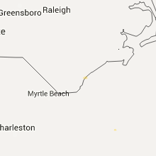
| 7:12 PM EDT | Trees down all over oconee county. no part of the county seen as worse than other...termed as they got it full blas in oconee county SC, 30 miles WSW of Greenville, SC |
| 8:20 PM EDT | At least one tree blown down in the calhoun falls are in abbeville county SC, 51.1 miles S of Greenville, SC |
Michigan
| Local Time | Report Details |
|---|---|
| 12:50 PM EDT | Spotter reported that a large tree limb about 6 inches in diameter had been snapped and landed on the roof of a house. time estimated by rada in ottawa county MI, 9.3 miles WSW of Grand Rapids, MI |
Arkansas
| Local Time | Report Details |
|---|---|
| 1:48 PM CDT | A tree fell across three cars in the mammoth spring state park area. no injuries were reported in fulton county AR, 79.1 miles S of Salem, MO |
| 2:23 PM CDT | Tree fell on a hous in randolph county AR, 91 miles SSE of Salem, MO |
| 2:23 PM CDT | Tree across the roa in randolph county AR, 92.4 miles NNW of Memphis, TN |
| 2:35 PM CDT | Several trees down across randolph county. winds estimated to be between 60 and 70 mp in randolph county AR, 92.4 miles NNW of Memphis, TN |
| 2:41 PM CDT | 57 knot wind reported at walnut ridge airpor in lawrence county AR, 81.6 miles NW of Memphis, TN |
| 2:50 PM CDT | Storm damage reported in craighead county AR, 58.7 miles NW of Memphis, TN |
| 2:53 PM CDT | Winds estimated to be greater than 60 mp in greene county AR, 67.9 miles NNW of Memphis, TN |
| 2:55 PM CDT | Tree crushed a shed on chadwick driv in greene county AR, 67.9 miles NNW of Memphis, TN |
| 2:55 PM CDT | Tree on a hous in randolph county AR, 91.9 miles NNW of Memphis, TN |
| 3:00 PM CDT | Canopy blown off paragould high schoo in greene county AR, 67.9 miles NNW of Memphis, TN |
| 3:00 PM CDT | Roof blown off local grocery stor in mississippi county AR, 54.4 miles NNW of Memphis, TN |
| 3:01 PM CDT | Ham operator measured 81 mph wind gus in craighead county AR, 59.8 miles NNW of Memphis, TN |
| 3:02 PM CDT | 18 wheeler blown over at exxon truck stop 3109 commerc in craighead county AR, 58.7 miles NW of Memphis, TN |
| 3:05 PM CDT | Tree blocking a street in paragoul in greene county AR, 67.9 miles NNW of Memphis, TN |
| 3:06 PM CDT | Significant wind damage in brookland. numerous trees down and a shed destroye in craighead county AR, 59.8 miles NNW of Memphis, TN |
| 3:11 PM CDT | Power lines down across hwy 63 west of jonesbor in craighead county AR, 58.7 miles NW of Memphis, TN |
| 3:14 PM CDT | Est winds near 68 mph with power outage in truman in poinsett county AR, 44.6 miles NW of Memphis, TN |
| 3:23 PM CDT | Power lines down on west state stree in craighead county AR, 45 miles NNW of Memphis, TN |
| 3:30 PM CDT | Overturned 18 wheeler on i55 at mile marker 6 in mississippi county AR, 54.3 miles N of Memphis, TN |
| 3:30 PM CDT | Tree on a house in monette via photo submitted to social medi in craighead county AR, 53.6 miles NNW of Memphis, TN |
| 3:37 PM CDT | Spotter estimates wind between 60 and 70 mph in wilso in mississippi county AR, 29 miles N of Memphis, TN |
Pennsylvania
| Local Time | Report Details |
|---|---|
| 2:50 PM EDT | Multiple trees down sr 321 south of bliss hill in mckean county PA, 80.5 miles S of Buffalo, NY |
| 3:30 PM EDT | Trees down near kane in mckean county PA, 77.6 miles NW of State College, PA |
| 3:36 PM EDT | Tree down on power lines on folk road near fredonia in mercer county PA, 62.7 miles NNW of Pittsburgh, PA |
| 4:56 PM EDT | Quarter sized hail reported near Tyrone, PA, 16.8 miles WSW of State College, PA, 1 inch hail mm 54 on i99 |
Florida
| Local Time | Report Details |
|---|---|
| 3:10 PM EDT | Mesonet sensor located over banana rive in brevard county FL, 45.9 miles ESE of Orlando, FL |
| 3:15 PM EDT | Mesonet sensor located over banana rive in brevard county FL, 45.9 miles ESE of Orlando, FL |
| 3:25 PM EDT | Four large branches from tree damaged trunk of a car. other tree damage also in the area. pea sized hail to in broward county FL, 40.6 miles N of Miami, FL |
| 3:40 PM EDT | Large palm tree down in deerfield. time estimated from radar. viewer by way of social medi in broward county FL, 40.9 miles NNE of Miami, FL |
| 3:40 PM EDT | Large palm tree down in deerfield near south military trail. time estimated from radar. viewer by way of social medi in broward county FL, 41.2 miles N of Miami, FL |
| 3:51 PM EDT | Quarter sized hail reported near Boynton Beach, FL, 53.7 miles SSE of Port Saint Lucie, FL, quater size hail reported on boynton beach blvd between military trail and jog rd. relayed by local media. |
| 3:53 PM EDT | Quarter sized hail reported near Boynton Beach, FL, 53.9 miles SSE of Port Saint Lucie, FL, quater hail reported and tree limbs down via palm beach county sheriffs office |
| 3:57 PM EDT | Large tree limb down. report received via social medi in palm beach county FL, 50.5 miles SSE of Port Saint Lucie, FL |
New York
| Local Time | Report Details |
|---|---|
| 3:26 PM EDT | Trees and wires down in cattaraugus county NY, 43.3 miles SSE of Buffalo, NY |
| 3:50 PM EDT | Trees and wires down in allegany county NY, 46.9 miles SE of Buffalo, NY |
| 4:21 PM EDT | Trees and wires down in allegany county NY, 53.4 miles ESE of Buffalo, NY |
| 4:31 PM EDT | Trees and wires down in allegany county NY, 63.2 miles ESE of Buffalo, NY |
| 4:55 PM EDT | Trees down. one blocking the roa in steuben county NY, 73.4 miles ESE of Buffalo, NY |
| 5:00 PM EDT | Trees dow in steuben county NY, 69.1 miles ESE of Buffalo, NY |
| 5:01 PM EDT | Trees dow in steuben county NY, 72.3 miles ESE of Buffalo, NY |
| 5:04 PM EDT | Trees blocking both lanes of i-86 at mile post 13 in steuben county NY, 76.9 miles ESE of Buffalo, NY |
| 5:20 PM EDT | Trees dow in steuben county NY, 77.5 miles SW of Syracuse, NY |
| 5:39 PM EDT | Trees dow in steuben county NY, 77.5 miles SW of Syracuse, NY |
| 5:40 PM EDT | Tree dow in steuben county NY, 76.2 miles SW of Syracuse, NY |
| 6:04 PM EDT | 10 inch dia. tree across roa in steuben county NY, 70.2 miles SW of Syracuse, NY |
| 6:08 PM EDT | Trees dow in steuben county NY, 78 miles SW of Syracuse, NY |
| 6:12 PM EDT | Trees dow in steuben county NY, 79.8 miles SW of Syracuse, NY |
West Virginia
| Local Time | Report Details |
|---|---|
| 4:22 PM EDT | Power lines down. power out in wood county WV, 67.1 miles N of Charleston, WV |
| 4:36 PM EDT | Trees and power lines down in wood county WV, 57.7 miles N of Charleston, WV |
| 4:45 PM EDT | Trees down in mason county WV, 50.2 miles NNW of Charleston, WV |
| 5:02 PM EDT | Tree down across rte 74 in ritchie county WV, 65.3 miles WNW of Elkins, WV |
| 5:10 PM EDT | Trees down on power line in mason county WV, 32.6 miles NNW of Charleston, WV |
| 5:12 PM EDT | Tree down across rte 18 in doddridge county WV, 60.2 miles WNW of Elkins, WV |
| 5:15 PM EDT | Reports of trees down near the town of elizabeth in wirt county WV, 50.6 miles NNE of Charleston, WV |
| 5:48 PM EDT | Trees and power lines dow in calhoun county WV, 41 miles NE of Charleston, WV |
| 5:54 PM EDT | Trees down in calhoun county WV, 40.2 miles NE of Charleston, WV |
| 6:06 PM EDT | Several trees dow in lincoln county WV, 25.5 miles W of Charleston, WV |
| 6:06 PM EDT | Roof blown off of car wash at virginia st. and penna av in kanawha county WV, 0.1 miles WSW of Charleston, WV |
| 6:12 PM EDT | Several trees dow in wayne county WV, 44.5 miles WSW of Charleston, WV |
| 6:15 PM EDT | Trees down in nicholas county WV, 48.8 miles ENE of Charleston, WV |
| 6:15 PM EDT | Storm damage reported in braxton county WV, 52 miles ENE of Charleston, WV |
| 6:20 PM EDT | Trees down along state route 4. time estimated from rada in braxton county WV, 52 miles ENE of Charleston, WV |
| 6:22 PM EDT | Trees down along polemick rd. time estimated by rada in braxton county WV, 49.6 miles ENE of Charleston, WV |
| 6:25 PM EDT | Several trees and powerlines down along centralia rd. time estimated from rada in braxton county WV, 49.3 miles WSW of Elkins, WV |
| 6:28 PM EDT | Tree down in boone county WV, 14.5 miles S of Charleston, WV |
| 6:30 PM EDT | Trees down in nicholas county WV, 53.7 miles E of Charleston, WV |
| 6:30 PM EDT | Trees uproote in upshur county WV, 21.6 miles WNW of Elkins, WV |
| 6:30 PM EDT | Roof and siding damage to trailer in upshur county WV, 21.6 miles WNW of Elkins, WV |
| 6:50 PM EDT | Trees dow in logan county WV, 33.4 miles SW of Charleston, WV |
| 6:50 PM EDT | Several trees and power lines dow in fayette county WV, 35.5 miles SE of Charleston, WV |
| 6:56 PM EDT | Tree across low gap r in boone county WV, 25.5 miles SSW of Charleston, WV |
| 7:00 PM EDT | Several trees dow in logan county WV, 39.4 miles SSW of Charleston, WV |
| 7:00 PM EDT | Several limbs and a tree down in fayette county WV, 35.5 miles SE of Charleston, WV |
| 7:07 PM EDT | Fire department reports two trees down within the community of crichton in greenbrier county... w in greenbrier county WV, 53.9 miles ESE of Charleston, WV |
| 7:09 PM EDT | Emergency manager reports several trees down within the community of quinwood in greenbrier county... w in boone county WV, 20.4 miles S of Charleston, WV |
| 7:09 PM EDT | Emergency manager reports several trees down within the community of quinwood in greenbrier county... w in greenbrier county WV, 54.4 miles ESE of Charleston, WV |
| 7:09 PM EDT | Emergency manager reports several trees down within the community of quinwood in greenbrier county... w in greenbrier county WV, 54.9 miles ESE of Charleston, WV |
| 7:15 PM EDT | Tree down across six mile road in boone county WV, 21.3 miles SSW of Charleston, WV |
| 7:15 PM EDT | Several trees down. power ou in mingo county WV, 58.2 miles SW of Charleston, WV |
| 7:30 PM EDT | Trees down in mingo county WV, 52.6 miles SSW of Charleston, WV |
| 7:35 PM EDT | Tree down across route 971 in wyoming county WV, 49.7 miles S of Charleston, WV |
| 7:39 PM EDT | Emergency manager reports a powerpole snapped in half by wind in the fairlea communit in greenbrier county WV, 45.2 miles NW of Roanoke, VA |
| 7:45 PM EDT | Trees down in wyoming county WV, 52.8 miles S of Charleston, WV |
| 7:46 PM EDT | Multiple trees and power lines down throughout the county in cabell county WV, 41.5 miles W of Charleston, WV |
| 8:00 PM EDT | Several trees and power lines dow in mcdowell county WV, 63.5 miles S of Charleston, WV |
| 8:12 PM EDT | Multiple trees were blown down along route 10 in the matoaka are in mercer county WV, 67.6 miles SSE of Charleston, WV |
| 8:12 PM EDT | Multiple trees were blown down along route 19 in the spanishburg are in mercer county WV, 66.1 miles W of Roanoke, VA |
Nebraska
| Local Time | Report Details |
|---|---|
| 3:49 PM CDT | Golf Ball sized hail reported near Pleasanton, NE, 44.6 miles W of Grand Island, NE, on going at this time. |
| 3:53 PM CDT | Quarter sized hail reported near Pleasanton, NE, 44 miles W of Grand Island, NE |
| 4:38 PM CDT | Golf Ball sized hail reported near Loup City, NE, 49.4 miles NW of Grand Island, NE, nickel to golf ball size hail in progress. |
| 5:30 PM CDT | Quarter sized hail reported near Mason City, NE, 60.9 miles WNW of Grand Island, NE |
| 5:39 PM CDT | Quarter sized hail reported near Ord, NE, 55.8 miles SSW of Oneill, NE |
| 5:53 PM CDT | Quarter sized hail reported near Ansley, NE, 61.4 miles WNW of Grand Island, NE, lots of hail that is severely stripping crops. |
| 10:00 PM CDT | Transmission lines down on garfield roa in lincoln county NE, 22.9 miles NE of North Platte, NE |
Mississippi
| Local Time | Report Details |
|---|---|
| 4:30 PM CDT | Tree down on polk lan in desoto county MS, 18.5 miles SE of Memphis, TN |
| 4:55 PM CDT | Tree on a car on rising star roa in marshall county MS, 43.3 miles SE of Memphis, TN |
| 5:05 PM CDT | Powerline down on the road east of senatobi in tate county MS, 40 miles SSE of Memphis, TN |
| 6:00 PM CDT | Numerous trees blocking several roads across the count in tishomingo county MS, 29.8 miles W of Florence, AL |
| 6:30 PM CDT | Storm damage reported in itawamba county MS, 39.8 miles SW of Florence, AL |
North Dakota
| Local Time | Report Details |
|---|---|
| 4:30 PM CDT | Quarter sized hail reported near Minot, ND, 0.5 miles SSW of Minot, ND, quarter size hail in north minot damaged at least 3 cars in a cenex parking lot. time estimate based on radar. |
| 5:45 PM CDT | Half Dollar sized hail reported near Voltaire, ND, 30.8 miles ESE of Minot, ND, broadcast media reported hail the size of half dollars still in ditches approx 90 mins after the storm passed. hail was likely much larger before melting. time estimate |
| 5:45 PM CDT | Time estimated from radar. trees snapped in minto park. relayed via social medi in walsh county ND, 69.8 miles E of Devils Lake, ND |
| 6:05 PM CDT | Golf Ball sized hail reported near Balfour, ND, 40.6 miles ESE of Minot, ND |
| 10:00 PM CDT | Time approximate. county official reported the top of the water tower taken off in the city of fairmoun in richland county ND, 57.7 miles S of Fargo, ND |
Montana
| Local Time | Report Details |
|---|---|
| 5:07 PM MDT | Storm damage reported in big horn county MT, 44.2 miles ESE of Billings, MT |
| 6:13 PM MDT | Storm damage reported in big horn county MT, 76.1 miles ESE of Billings, MT |
| 6:36 PM MDT | Strong winds and heavy rain for 30 minute in big horn county MT, 70.3 miles ESE of Billings, MT |
Alabama
| Local Time | Report Details |
|---|---|
| 6:10 PM CDT | Numerous trees and power lines downed by thunderstorm wind in lauderdale county AL, 0.3 miles W of Florence, AL |
| 6:20 PM CDT | A few trees were downed across the eastern portion of frankline count in franklin county AL, 20.3 miles S of Florence, AL |
| 6:25 PM CDT | Numerous trees and power lines downed by thunderstorm winds along highway 20 and highway 10 in lawrence county AL, 17.2 miles ESE of Florence, AL |
| 6:35 PM CDT | A billbarod was knocked down... along trees and fences that were blown over along wall triana near the river landing subdivisio in madison county AL, 54.3 miles ESE of Florence, AL |
| 6:39 PM CDT | A tree was downed by thunderstorm wind in madison county AL, 53.1 miles E of Florence, AL |
| 6:41 PM CDT | A few trees were downed by thunderstorm wind in colbert county AL, 2.5 miles SSW of Florence, AL |
| 6:50 PM CDT | Numerous trees and power lines down scattered through the cit in morgan county AL, 41.7 miles ESE of Florence, AL |
| 6:58 PM CDT | Tree down on state highway 129 and loveless lane in marion county AL, 44.2 miles S of Florence, AL |
| 7:00 PM CDT | A tree was downed by thunderstorm winds onto a hom in morgan county AL, 52.8 miles SE of Florence, AL |
| 7:03 PM CDT | A few trees were downed by thunderstorm wind in cullman county AL, 49.5 miles NNW of Birmingham, AL |
| 7:05 PM CDT | Trees reported down countywide in winston county AL, 47.5 miles SSE of Florence, AL |
| 7:06 PM CDT | *** 1 fatal *** a tree fell onto a man along county road 113 in cullman county AL, 48.4 miles N of Birmingham, AL |
| 7:10 PM CDT | A tree was downed by thunderstorm winds on highway 7 in jackson county AL, 63.8 miles WSW of Chattanooga, TN |
| 7:14 PM CDT | Damage to gas pumps at marathon gas station on academy dr in jefferson county AL, 15 miles SW of Birmingham, AL |
| 7:16 PM CDT | Numerous trees were downed by thunderstorm wind in cullman county AL, 49.7 miles N of Birmingham, AL |
| 7:18 PM CDT | Trees down blocking road at highway 253 and highway 44 in marion county AL, 55.4 miles S of Florence, AL |
| 7:20 PM CDT | Trees down on brakefield dairy rd with one tree down on a vehicl in walker county AL, 37.5 miles NW of Birmingham, AL |
| 7:20 PM CDT | Golf Ball sized hail reported near Bremen, AL, 34.5 miles NNW of Birmingham, AL, golfball sized hail was reported. |
| 7:26 PM CDT | Trees down in winfield along county 4 and apple st in marion county AL, 60.4 miles S of Florence, AL |
| 7:34 PM CDT | Trees down in roadway near highway 278 and highway 79 in blount county AL, 48 miles NNE of Birmingham, AL |
| 7:41 PM CDT | Trees down on swan bridge road in blount county AL, 35.2 miles NNE of Birmingham, AL |
| 7:45 PM CDT | Trees and powerlines down on bagley rd and jim goggans rd in jefferson county AL, 18.9 miles NNW of Birmingham, AL |
| 7:45 PM CDT | Large tree snapped in dora. reported via social media with phot in walker county AL, 21.2 miles NW of Birmingham, AL |
| 7:55 PM CDT | Trees down blocking fieldstown road in gardendale in jefferson county AL, 8.4 miles N of Birmingham, AL |
| 7:57 PM CDT | Near jamestown manor drive and main street in gardendale in jefferson county AL, 7.6 miles N of Birmingham, AL |
| 8:00 PM CDT | Damage to an outbuilding reported near tarrant rd and skelton rd in gardendale in jefferson county AL, 8.3 miles N of Birmingham, AL |
| 8:01 PM CDT | Tree down on house on hillcrest dr. also several trees down in mt olive...minor...and adamsville in jefferson county AL, 8.1 miles W of Birmingham, AL |
| 8:01 PM CDT | Tree on car near 2nd st ne in center point in jefferson county AL, 11.7 miles NE of Birmingham, AL |
| 8:07 PM CDT | Trees reported down on i-59 near mp 139 in jefferson county AL, 12.5 miles ENE of Birmingham, AL |
| 8:07 PM CDT | Trees and powerlines down in springville on tucker lane as well as wilson st in st. clair county AL, 25.7 miles NE of Birmingham, AL |
| 8:12 PM CDT | Trees down near green springs ave. reported via social medi in jefferson county AL, 2.8 miles S of Birmingham, AL |
| 8:15 PM CDT | Trees down at highway 52 and highway 93 in helena in shelby county AL, 16.2 miles SSW of Birmingham, AL |
| 8:15 PM CDT | Trees down at highway 17 and fieldstone drive in helena in shelby county AL, 16.7 miles S of Birmingham, AL |
| 8:15 PM CDT | A few trees were downed by thunderstorm winds along county road 32 in dekalb county AL, 37.7 miles SW of Chattanooga, TN |
| 8:15 PM CDT | A few trees and power lines were downed by thunderstorm wind in dekalb county AL, 31.5 miles SW of Chattanooga, TN |
| 8:15 PM CDT | Trees and powerlines down along eastern valley rd in bessemer in jefferson county AL, 15.2 miles SW of Birmingham, AL |
| 8:15 PM CDT | Tree down on house near mountain branch dr and tyler rd in jefferson county AL, 7 miles S of Birmingham, AL |
| 8:17 PM CDT | Trees down in brook highland neighborhood. also tree down on inverness country club rd. reported via social medi in shelby county AL, 9.8 miles SE of Birmingham, AL |
| 8:17 PM CDT | Large tree down at riverchase parkway and chestnut oaks drive. reported via social medi in shelby county AL, 11.7 miles S of Birmingham, AL |
| 8:19 PM CDT | Tree on house causing structural damage at royal chase dr near royal lane. relayed via emergency manage in shelby county AL, 13.1 miles S of Birmingham, AL |
| 8:19 PM CDT | Trees and powerlines down at multiple locations nw of adger in jefferson county AL, 21.1 miles WSW of Birmingham, AL |
| 8:19 PM CDT | Tree down on rocky ridge rd between shades crest rd and rocky brook dr. reported via social medi in jefferson county AL, 5.1 miles SE of Birmingham, AL |
| 8:20 PM CDT | Tree down at overton rd and colchester rd in jefferson county AL, 5.8 miles SE of Birmingham, AL |
| 8:20 PM CDT | Trees and powerlines down along jolley rd in jefferson county AL, 19.8 miles SSW of Birmingham, AL |
| 8:21 PM CDT | Trees down on i-65 southbound near mile marker 240 in shelby county AL, 18 miles S of Birmingham, AL |
| 8:27 PM CDT | Trees down near county 339 and saddle lake dr in shelby county AL, 20.1 miles S of Birmingham, AL |
| 8:48 PM CDT | Trees and powerlines down across northern chilton county in chilton county AL, 38.8 miles S of Birmingham, AL |
Minnesota
| Local Time | Report Details |
|---|---|
| 6:45 PM CDT | Time estimated from radar. shingle damage and trees snapped in perham. relayed via social medi in otter tail county MN, 60.6 miles ESE of Fargo, ND |
Colorado
| Local Time | Report Details |
|---|---|
| 7:13 PM MDT | Storm damage reported in prowers county CO, 99.4 miles W of Garden City, KS |
| 7:15 PM MDT | At least 1 power pole down in lamar. event time estimated in prowers county CO, 95.7 miles W of Garden City, KS |
| 7:43 PM MDT | Storm damage reported in kit carson county CO, 60.8 miles SSE of Yuma, CO |
South Dakota
| Local Time | Report Details |
|---|---|
| 7:15 PM MDT | Quarter sized hail reported near Rapid City, SD, 13.2 miles SW of Rapid City, SD, 3-4 inches of pea size hail accumulated with a few quarters near intersection of highway 16 and beretta road. |
| 7:20 PM MDT | Half Dollar sized hail reported near Rapid City, SD, 13.4 miles SW of Rapid City, SD, mostly pea size 3-5 inches deep. a few larger stones to half dollar size. fog forming over hail path. |
| 7:25 PM MDT | Pea size hail in pennington county SD, 16.4 miles SSW of Rapid City, SD |
| 7:25 PM MDT | Half Dollar sized hail reported near Rapid City, SD, 13.4 miles SW of Rapid City, SD, mostly pea size 3-5 inches deep. a few larger stones to half dollar size. fog forming over hail path. |
| 7:42 PM MDT | Pea size hail covered the ground in custer county SD, 15.7 miles SSW of Rapid City, SD |
| 7:51 PM MDT | Quarter sized hail reported near Hermosa, SD, 16.8 miles S of Rapid City, SD |
| 7:55 PM MDT | Some dime size hai in custer county SD, 16.8 miles S of Rapid City, SD |
Arizona
| Local Time | Report Details |
|---|---|
| 6:27 PM MST | And 0.25 in. hai in maricopa county AZ, 14.5 miles ESE of Phoenix, AZ |
Wyoming
| Local Time | Report Details |
|---|---|
| 8:07 PM MDT | Storm damage reported in campbell county WY, 20.2 miles NW of Gillette, WY |
Connect with Interactive Hail Maps