

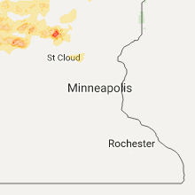
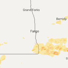
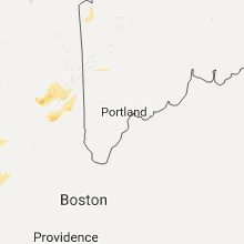
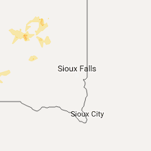
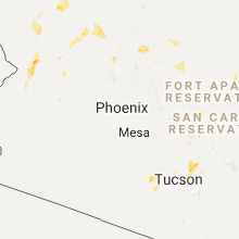
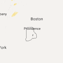
Hail Map for Monday, July 17, 2017

Number of Impacted Households on 7/17/2017
0
Impacted by 1" or Larger Hail
0
Impacted by 1.75" or Larger Hail
0
Impacted by 2.5" or Larger Hail
Square Miles of Populated Area Impacted on 7/17/2017
0
Impacted by 1" or Larger Hail
0
Impacted by 1.75" or Larger Hail
0
Impacted by 2.5" or Larger Hail


Cities Most Affected by Hail Storms of 7/17/2017
| Hail Size | Demographics of Zip Codes Affected | ||||||
|---|---|---|---|---|---|---|---|
| City | Count | Average | Largest | Pop Density | House Value | Income | Age |
| Prescott, AZ | 1 | 1.75 | 1.75 | 15 | $204k | $39.6k | 56.5 |
| Eagle Bend, MN | 1 | 1.75 | 1.75 | 13 | $46k | $29.6k | 44.5 |
| Biwabik, MN | 1 | 1.75 | 1.75 | 0 | $43k | $29.5k | 47.0 |
| Parkers Prairie, MN | 1 | 1.75 | 1.75 | 13 | $61k | $30.5k | 46.6 |
| Fergus Falls, MN | 1 | 1.75 | 1.75 | 66 | $82k | $36.2k | 44.4 |
| Bertha, MN | 1 | 1.75 | 1.75 | 16 | $38k | $28.4k | 35.1 |
Hail and Wind Damage Spotted on 7/17/2017
Filter by Report Type:Hail ReportsWind Reports
States Impacted
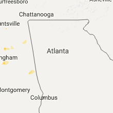
South Carolina, Florida, Arizona, New York, Maine, Pennsylvania, Vermont, Virginia, Maryland, Alabama, Illinois, South Dakota, North Dakota, Minnesota, Nevada, North Carolina, New Hampshire, Utah, West Virginia, Mississippi, Wyoming, Georgia, Massachusetts, Kansas, Nebraska, MontanaSouth Carolina
| Local Time | Report Details |
|---|---|
| 8:56 AM EDT | Quarter sized hail reported near Taylors, SC, 23.4 miles NE of Greenville, SC, quarter sized hail in the highland community. also had strong wind but no damage reported although tigerville fire department reported there are scattered power outages |
| 8:56 PM EDT | Quarter sized hail reported near Taylors, SC, 23.4 miles NE of Greenville, SC, quarter sized hail in the highland community. also had strong wind but no damage reported although tigerville fire department reported there are scattered power outages |
Florida
| Local Time | Report Details |
|---|---|
| 11:30 AM EDT | There were a few sporadic power outages in the area due to trees from strong wind as well as lightnin in madison county FL, 37.1 miles E of Tallahassee, FL |
| 3:15 PM EDT | Duval county emergency management reports a tree downed along dodge road that crashed through the living room of a house. time of damage based on radar dat in duval county FL, 3.4 miles NW of Jacksonville, FL |
| 3:40 PM EDT | Duval county emergency management reports that a tree was downed by strong wind gusts and crashed into an apartment building along harts road.time of damage based on ra in duval county FL, 7.5 miles N of Jacksonville, FL |
| 4:48 PM EDT | Quarter sized hail reported near Sorrento, FL, 20.3 miles NNW of Orlando, FL, report of quarter sized hail and trees down in the mount plymouth/sorrento area. |
| 5:55 PM EDT | Quarter sized hail reported near Saint Cloud, FL, 21.1 miles SSE of Orlando, FL, trained spotter reports quarter sized hail near us 192 in st. cloud |
Arizona
| Local Time | Report Details |
|---|---|
| 9:14 AM MST | Golf Ball sized hail reported near Prescott, AZ, 61.7 miles SW of Flagstaff, AZ, five miles north of iron springs road on williamson valley rd. -- golf ball sized hail. |
| 3:32 PM MST | Ksad asos wind gust to 50 kt in graham county AZ, 79 miles W of Silver City, NM |
| 4:02 PM MST | Quarter sized hail reported near Valentine, AZ, 70.1 miles NNE of Lake Havasu City, AZ, quarter size hail reported near hackberry rd. time estimated via radar. |
| 5:25 PM MST | Power lines and trees dow in yavapai county AZ, 67.4 miles E of Lake Havasu City, AZ |
New York
| Local Time | Report Details |
|---|---|
| 12:35 PM EDT | Quarter sized hail reported near Holland Patent, NY, 46.7 miles ENE of Syracuse, NY, mostly quarter size hail with a few golf ball sized. also large tree limbs fell. |
| 12:58 PM EDT | Tree down blocking rodawai in in vicinity of fillmore glenn state park in cayuga county NY, 27.2 miles SSW of Syracuse, NY |
| 1:02 PM EDT | Tree down in roadway... windows blown out of residential structure in cayuga county NY, 27.2 miles SSW of Syracuse, NY |
| 1:05 PM EDT | Power line down in roadway in cayuga county NY, 27.2 miles SSW of Syracuse, NY |
| 1:10 PM EDT | Quarter sized hail reported near Lake Pleasant, NY, 59.5 miles NNW of Schenectady, NY, also reported trees down at mason lake. |
| 2:42 PM EDT | Downed tree. time estimated by rada in fulton county NY, 35.5 miles NW of Schenectady, NY |
| 3:16 PM EDT | Power outage due to downed tre in fulton county NY, 30.4 miles NNW of Schenectady, NY |
| 3:49 PM EDT | Trees and electrical wires down in broome county NY, 51.9 miles NNW of Scranton, PA |
| 3:50 PM EDT | Tree down causing a motor vehicle accident on rt. 12 and oak hill r in broome county NY, 57.6 miles N of Scranton, PA |
| 3:58 PM EDT | Tree and powerlines down in the vicinity of june st. and birdsall s in broome county NY, 51.9 miles NNW of Scranton, PA |
| 4:01 PM EDT | Downed tree on truax roa in montgomery county NY, 15.4 miles NW of Schenectady, NY |
| 4:03 PM EDT | Tree down on power lines on pigeon hill r in broome county NY, 57.6 miles N of Scranton, PA |
| 4:19 PM EDT | Wires down. time estimated by rada in saratoga county NY, 8.3 miles N of Schenectady, NY |
| 4:30 PM EDT | More than 10 trees uprooted or snapped on an ouaquaga road property in broome county NY, 46.2 miles N of Scranton, PA |
| 4:31 PM EDT | Downed tre in saratoga county NY, 11 miles NNE of Schenectady, NY |
| 4:51 PM EDT | Trees dow in saratoga county NY, 7.1 miles ENE of Schenectady, NY |
Maine
| Local Time | Report Details |
|---|---|
| 12:52 PM EDT | One large tree and several small trees down. time estimated based on rada in penobscot county ME, 58 miles SSW of Caribou, ME |
| 5:50 PM EDT | Quarter sized hail reported near Jackman, ME, 91.7 miles NW of Bangor, ME, mostly dime and nickel size hail with some larger stones mixed in. time estimated from radar. |
Pennsylvania
| Local Time | Report Details |
|---|---|
| 1:30 PM EDT | Quarter sized hail reported near Wilkes Barre, PA, 18.6 miles SW of Scranton, PA |
| 1:56 PM EDT | Ping Pong Ball sized hail reported near Wilkes Barre, PA, 15.9 miles SW of Scranton, PA, report of 1.5 hail and 1.76 of rain in 40 minutes |
| 2:27 PM EDT | Tree down blocking roadway in susquehanna county PA, 38.9 miles N of Scranton, PA |
| 2:35 PM EDT | Trees dow in luzerne county PA, 19.6 miles SW of Scranton, PA |
| 2:40 PM EDT | Multiple trees down with debris in roadway in the vicinity of franklin hill r in susquehanna county PA, 38.2 miles N of Scranton, PA |
| 4:40 PM EDT | Tree down on wires resulting in road closur in northampton county PA, 54.8 miles SSE of Scranton, PA |
| 5:20 PM EDT | Trees dow in susquehanna county PA, 31.1 miles NNW of Scranton, PA |
| 5:20 PM EDT | Trees down in susquehanna county PA, 32.6 miles N of Scranton, PA |
Vermont
| Local Time | Report Details |
|---|---|
| 2:30 PM EDT | Quarter sized hail reported near Pittsfield, VT, 55.7 miles SSE of Burlington, VT, hail size of quarters along the killington/pittsfield town line along rt 100 |
| 5:20 PM EDT | Quarter sized hail reported near Ludlow, VT, 74.7 miles ENE of Schenectady, NY |
| 6:00 PM EDT | Trees and powerlines down on south hill road in windsor county VT, 73.4 miles ENE of Schenectady, NY |
| 6:00 PM EDT | Quarter sized hail reported near Ludlow, VT, 73.4 miles ENE of Schenectady, NY |
| 6:22 PM EDT | Quarter sized hail reported near Proctorsville, VT, 76.6 miles ENE of Schenectady, NY |
Virginia
| Local Time | Report Details |
|---|---|
| 3:10 PM EDT | Tree down on private property off of big ridge roa in grayson county VA, 54.5 miles E of Bristol, TN |
| 3:12 PM EDT | Tree down near intersection of bethel and big ridge road in grayson county VA, 53.3 miles E of Bristol, TN |
| 7:15 PM EDT | Trees down at 300 bumpass road and green coral roa in louisa county VA, 31.8 miles N of Richmond, VA |
| 7:32 PM EDT | Multiple trees knocked down. time estimated from rada in cumberland county VA, 26.6 miles WNW of Richmond, VA |
Maryland
| Local Time | Report Details |
|---|---|
| 3:30 PM EDT | Quarter sized hail reported near Gaithersburg, MD, 29 miles W of Baltimore, MD |
| 3:34 PM EDT | Tree down along woodfield road at rocky road in montgomery county MD, 30.9 miles W of Baltimore, MD |
| 3:34 PM EDT | Quarter sized hail reported near Gaithersburg, MD, 29 miles W of Baltimore, MD |
| 3:34 PM EDT | Two large tree branches blocked the intersecton of augusta farm lane and woodfield roa in montgomery county MD, 31 miles W of Baltimore, MD |
| 3:37 PM EDT | Tree down along woodfield road at churchill downs road in montgomery county MD, 30.4 miles W of Baltimore, MD |
| 3:39 PM EDT | Multiple trees down at the intersection of churchill downs road and woodfield roa in montgomery county MD, 30.4 miles W of Baltimore, MD |
| 3:58 PM EDT | Tree down near rt 140 and glen falls rd in baltimore county MD, 19.2 miles NW of Baltimore, MD |
| 4:24 PM EDT | Several tree branches down in the 9600 block of brink rd in montgomery county MD, 32.1 miles WSW of Baltimore, MD |
| 6:45 PM EDT | Quarter sized hail reported near Centreville, MD, 33.7 miles ESE of Baltimore, MD |
Alabama
| Local Time | Report Details |
|---|---|
| 2:30 PM CDT | A few trees were blown down near mood in st. clair county AL, 21 miles ENE of Birmingham, AL |
| 3:17 PM CDT | Trees blown down on sunset driv in jefferson county AL, 5.2 miles SSE of Birmingham, AL |
| 3:17 PM CDT | Power lines were blown down on north river roa in jefferson county AL, 6.2 miles ESE of Birmingham, AL |
| 3:20 PM CDT | Trees blown down on southridge driv in jefferson county AL, 5.7 miles SSE of Birmingham, AL |
| 3:20 PM CDT | A large tree down and blocking the road at montevallo road and overhill roa in jefferson county AL, 3.2 miles SE of Birmingham, AL |
| 3:22 PM CDT | Trees down on overton roa in jefferson county AL, 5 miles SE of Birmingham, AL |
| 3:26 PM CDT | Power lines were blown down on cr 44... cr 698... and cr 102 near cedar bluf in cherokee county AL, 58.5 miles SSW of Chattanooga, TN |
| 3:36 PM CDT | Trees down on indian hills road and mission roa in jefferson county AL, 5.6 miles S of Birmingham, AL |
| 3:43 PM CDT | Multiple trees were blown down near the intersection of cr 70 and cr 36 near sand roc in cherokee county AL, 63.8 miles SSW of Chattanooga, TN |
| 3:43 PM CDT | Trees and power lines were blown down on sand rock avenu in cherokee county AL, 60.8 miles SSW of Chattanooga, TN |
| 4:00 PM CDT | Trees down blocking a lane on us highway 411 near the etowah and cherokee county lin in cherokee county AL, 69.9 miles NE of Birmingham, AL |
| 4:00 PM CDT | Trees down blocking a lane on us highway 411 near the etowah and cherokee county lin in cherokee county AL, 69.9 miles NE of Birmingham, AL |
| 4:18 PM CDT | Trees blown down blocking both lanes of traffic on horseshoe bend roa in tallapoosa county AL, 26.2 miles NW of Auburn, AL |
| 4:24 PM CDT | A few trees were blown down around alexander city on tiger lane... kerley patten road... and mallory circl in tallapoosa county AL, 33.6 miles NW of Auburn, AL |
| 4:30 PM CDT | A large tree and power lines down on ross drive and coates bend roa in etowah county AL, 64.2 miles NE of Birmingham, AL |
| 4:39 PM CDT | Tree down on east meighan blvd blocking a lan in etowah county AL, 58.6 miles NE of Birmingham, AL |
| 4:42 PM CDT | A large tree and several power poles knocked down on tuscaloosa avenu in etowah county AL, 57.1 miles NE of Birmingham, AL |
| 4:44 PM CDT | Trees and power lines down at 12th street and alabama avenu in etowah county AL, 57.1 miles NE of Birmingham, AL |
| 4:48 PM CDT | A few trees were blown down near mood in st. clair county AL, 21 miles ENE of Birmingham, AL |
| 5:12 PM CDT | A few trees were blown down around walnut grov in etowah county AL, 48 miles NE of Birmingham, AL |
| 5:31 PM CDT | Trees and power lines down on tyler stree in etowah county AL, 57.5 miles NE of Birmingham, AL |
Illinois
| Local Time | Report Details |
|---|---|
| 3:00 PM CDT | Several trees and power lines down across tow in jackson county IL, 34.1 miles NNE of Cape Girardeau, MO |
South Dakota
| Local Time | Report Details |
|---|---|
| 2:07 PM MDT | Quarter sized hail reported near Buffalo Gap, SD, 34.8 miles S of Rapid City, SD, car windshield broken due to hail |
| 4:08 PM MDT | Quarter sized hail reported near Oglala, SD, 58.2 miles SSE of Rapid City, SD |
| 5:25 PM CDT | Quarter sized hail reported near Huron, SD, 70.7 miles SSE of Aberdeen, SD, few hail stones as big as quarters and a brief period of gusty winds estimated up to 60 mph. |
| 5:38 PM CDT | Storm damage reported in lyman county SD, 17.4 miles S of Pierre, SD |
| 6:10 PM CDT | 60 to 70 mph winds and dime size hai in lyman county SD, 31 miles SE of Pierre, SD |
| 6:15 PM CDT | 60 mph wind gusts and pea to dime sized hai in clark county SD, 59.4 miles SE of Aberdeen, SD |
| 6:47 PM CDT | Storm damage reported in lyman county SD, 34.8 miles SSE of Pierre, SD |
| 7:02 PM CDT | Quarter sized hail reported near Wolsey, SD, 69.3 miles S of Aberdeen, SD, hail up to the size of quarters and wind gusts estimated at 60 mph. some tree branches blown down and corn was tipped. |
| 7:28 PM CDT | Storm damage reported in lyman county SD, 62.2 miles SE of Pierre, SD |
| 7:30 PM CDT | Nice rain and no hail... but pretty strong winds in beadle county SD, 73.5 miles S of Aberdeen, SD |
| 7:44 PM CDT | Kicked up a large amount of dus in brule county SD, 64.2 miles SE of Pierre, SD |
| 7:45 PM CDT | Big tree down in huron... blocking a city stree in beadle county SD, 77 miles S of Aberdeen, SD |
| 6:50 PM MDT | Storm damage reported in pennington county SD, 4.3 miles SSW of Rapid City, SD |
| 6:50 PM MDT | Storm damage reported in pennington county SD, 4.6 miles SW of Rapid City, SD |
| 6:50 PM MDT | Quarter sized hail reported near Hot Springs, SD, 41.2 miles SSW of Rapid City, SD |
| 7:05 PM MDT | Storm damage reported in pennington county SD, 20 miles E of Rapid City, SD |
| 8:17 PM CDT | Strong winds ahead of the storm stirred up enough dust to reduce visibility to less than 1/8 of a mil in kingsbury county SD, 76.3 miles NW of Sioux Falls, SD |
| 8:40 PM CDT | Time estimated from rada in kingsbury county SD, 57 miles NNW of Sioux Falls, SD |
| 8:40 PM CDT | Time estimated from rada in kingsbury county SD, 59.3 miles NNW of Sioux Falls, SD |
| 8:45 PM CDT | Storm damage reported in kingsbury county SD, 57 miles NNW of Sioux Falls, SD |
| 8:24 PM MDT | Storm damage reported in oglala lakota county SD, 67.7 miles SSE of Rapid City, SD |
| 1:24 AM MDT | Radar estimated time (gust front in corson county SD, 83.7 miles S of Bismarck, ND |
| 3:19 AM CDT | Occurred with outflow ahead of thunderstorm in walworth county SD, 81.6 miles N of Pierre, SD |
| 5:30 AM CDT | Storm damage reported in brown county SD, 6.5 miles W of Aberdeen, SD |
North Dakota
| Local Time | Report Details |
|---|---|
| 3:40 PM CDT | Quarter sized hail reported near Wahpeton, ND, 42.6 miles S of Fargo, ND, second round of hail. lots of nickel to quarter sized. |
Minnesota
| Local Time | Report Details |
|---|---|
| 3:55 PM CDT | Semi truck and trailer combination blown over on u. s. highway 10. time estimated based on rada in otter tail county MN, 67.4 miles ESE of Fargo, ND |
| 4:05 PM CDT | Quarter sized hail reported near Fergus Falls, MN, 54.5 miles SSE of Fargo, ND, large hail fell for several minutes across southern orwell township. |
| 4:10 PM CDT | Half Dollar sized hail reported near Bluffton, MN, 69.5 miles SSW of Bemidji, MN, hail of quarter to half dollar size. |
| 4:42 PM CDT | Golf Ball sized hail reported near Parkers Prairie, MN, 88.1 miles NNE of Montevideo, MN, quarter to golf ball sized hail covered the highway. few stones still falling at 445 pm cdt. |
| 4:50 PM CDT | Ping Pong Ball sized hail reported near Clitherall, MN, 73.1 miles SE of Fargo, ND |
| 4:55 PM CDT | Trees down across hwy 64. report relayed from nws-mpx. time estimated from rada in cass county MN, 68.8 miles S of Bemidji, MN |
| 4:55 PM CDT | Golf Ball sized hail reported near Fergus Falls, MN, 62.3 miles SSE of Fargo, ND, lots of quarter to golf ball sized hail and strong winds across southern aastad township. |
| 5:05 PM CDT | 12 to 16 inch box elder tree snapped about 8 to 10 ft off the ground. winds came after the storm had passe in cass county MN, 54.2 miles ESE of Bemidji, MN |
| 5:06 PM CDT | Golf Ball sized hail reported near Bertha, MN, 85.9 miles S of Bemidji, MN |
| 5:08 PM CDT | Golf Ball sized hail reported near Eagle Bend, MN, 89.2 miles NNE of Montevideo, MN |
| 5:10 PM CDT | Spotter reported 6" tree snapped at residenc in crow wing county MN, 70.9 miles SSE of Bemidji, MN |
| 5:15 PM CDT | Ping Pong Ball sized hail reported near Ashby, MN, 71.2 miles SE of Fargo, ND, lots of quarter to ping pong ball sized hail near interstate 94 in western pelican lake township. |
| 5:23 PM CDT | Storm damage reported in crow wing county MN, 81 miles SSE of Bemidji, MN |
| 5:33 PM CDT | Social media report and photo of damage to a dock on the western end of gull lak in cass county MN, 74.3 miles SSE of Bemidji, MN |
| 5:40 PM CDT | Trees down on powerlines both east & northeast of browerville. time estimated from rada in todd county MN, 91.3 miles NNE of Montevideo, MN |
| 5:50 PM CDT | Several large trees down on the north side of brando in douglas county MN, 70.6 miles N of Montevideo, MN |
| 5:55 PM CDT | Quarter sized hail reported near Randall, MN, 97.2 miles S of Bemidji, MN, between 545 pm and 645 pm spotter measured 1.50 inches of rain. |
| 6:20 PM CDT | Large tree limbs dow in morrison county MN, 87.5 miles NW of Minneapolis, MN |
| 6:30 PM CDT | Numerous tree limbs down in pier in morrison county MN, 80.4 miles NNW of Minneapolis, MN |
| 6:35 PM CDT | Golf Ball sized hail reported near Biwabik, MN, 52.5 miles NNW of Duluth, MN, relayed report of golf ball size hail from local media. |
| 6:40 PM CDT | Numerous tree branches dow in douglas county MN, 68 miles N of Montevideo, MN |
| 6:45 PM CDT | Quarter sized hail reported near Randall, MN, 97.2 miles S of Bemidji, MN |
| 6:53 PM CDT | Quarter sized hail reported near Biwabik, MN, 52.6 miles NNW of Duluth, MN, reported via off-duty officer through 911 center. |
| 7:00 PM CDT | Tree limbs down blocking streets in tow in todd county MN, 82.3 miles NNE of Montevideo, MN |
| 1:38 AM CDT | Quarter sized hail reported near Bemidji, MN, 4.9 miles WNW of Bemidji, MN, nickel to quarter sized hail between wilton and bemidji |
Nevada
| Local Time | Report Details |
|---|---|
| 2:24 PM PDT | Wind gust of 60 mph. site lsgt in clark county NV, 16 miles S of Las Vegas, NV |
| 2:28 PM PDT | Wind gust of 65 mph. site whlr in clark county NV, 15.5 miles S of Las Vegas, NV |
| 2:50 PM PDT | Six large trees uprooted and destroyed. eight small trees heavily damaged. two road signs damaged and fencing destroyed at sierra vista high schoo in clark county NV, 11.1 miles SW of Las Vegas, NV |
| 2:50 PM PDT | Wooden structure destroyed from strong winds near w wigwam and s durango dr. pictures sent in via social medi in clark county NV, 12.5 miles SW of Las Vegas, NV |
| 2:50 PM PDT | Several trees downed in restaurant parking lo in clark county NV, 10.6 miles SW of Las Vegas, NV |
| 2:52 PM PDT | Tree downed near w robindale rd and s tenaya wa in clark county NV, 10.8 miles SW of Las Vegas, NV |
| 2:55 PM PDT | Multiple trees downed near w windmill ln and rainbow blvd. pictures sent in via social medi in clark county NV, 11 miles SW of Las Vegas, NV |
| 2:55 PM PDT | Tree uprooted near blue diamond rd and decatur blvd. picture sent in via social medi in clark county NV, 10.5 miles SSW of Las Vegas, NV |
| 3:05 PM PDT | Large tree downed by thunderstorm winds at bermuda and windmill. picture sent in via social medi in clark county NV, 9.1 miles S of Las Vegas, NV |
| 3:15 PM PDT | Brick wall destroyed near silverado ranch blvd and lindell. picture sent in via social medi in clark county NV, 12 miles SSW of Las Vegas, NV |
| 3:15 PM PDT | Large tree limb downed onto fence near e windmill ln and bermuda rd. picture sent in via social medi in clark county NV, 9.1 miles S of Las Vegas, NV |
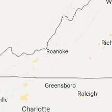
North Carolina
| Local Time | Report Details |
|---|---|
| 5:26 PM EDT | Quarter sized hail reported near Taylorsville, NC, 51.6 miles NNW of Charlotte, NC, quarter sized hail. very strong wind seeing limbs blow by in the parking lot but not sure how large the limbs were. |
| 5:26 PM EDT | Numerous trees down around taylorsvill in alexander county NC, 51.8 miles NNW of Charlotte, NC |
| 5:50 PM EDT | Multiple trees down across western alexander count in alexander county NC, 47.9 miles NNW of Charlotte, NC |
| 6:05 PM EDT | Quarter sized hail reported near Hickory, NC, 47.7 miles NW of Charlotte, NC, nickel to quarter sized hail on north side of hickory. strong wind but no sign yet of wind damage. |
| 6:09 PM EDT | Lenoir fd reports trees on powerlin in caldwell county NC, 60.1 miles SE of Bristol, TN |
| 6:15 PM EDT | Multiple trees down in the are in mcdowell county NC, 63 miles NNE of Greenville, SC |
| 6:26 PM EDT | Quarter sized hail reported near Rhodhiss, NC, 50.4 miles NW of Charlotte, NC, hail was increasing at the time of the call going from dime sized to quarter sized. strong wind also but so far no damage. |
| 6:27 PM EDT | Quarter sized hail reported near Hickory, NC, 49.9 miles NW of Charlotte, NC, dime to quarter sized hail about a quarter mile south of the river on the connelly springs side. |
| 6:40 PM EDT | Tree down on berea church roa in burke county NC, 50.8 miles NW of Charlotte, NC |
| 6:45 PM EDT | Multiple trees down across western alexander count in alexander county NC, 47.9 miles NNW of Charlotte, NC |
| 6:52 PM EDT | Tree on i40 at mm 11 in burke county NC, 50.8 miles NW of Charlotte, NC |
| 6:52 PM EDT | Tree across miller bridge rd at shoupes grove church r in burke county NC, 49.4 miles NW of Charlotte, NC |
| 6:57 PM EDT | Several trees down on robinson s in burke county NC, 50.3 miles NW of Charlotte, NC |
| 7:13 PM EDT | Power pole snapped with lines on ground at us70 near east burke blv in burke county NC, 50.4 miles NW of Charlotte, NC |
New Hampshire
| Local Time | Report Details |
|---|---|
| 5:40 PM EDT | Wires down around tow in grafton county NH, 75 miles WNW of Portland, ME |
| 7:20 PM EDT | Quarter sized hail reported near Ashland, NH, 68.9 miles W of Portland, ME, quarter to nickel size hail |
| 7:50 PM EDT | Trees and wires down in bartlet in carroll county NH, 58.8 miles WNW of Portland, ME |
| 8:05 PM EDT | Quarter sized hail reported near Tamworth, NH, 54 miles WNW of Portland, ME |
Utah
| Local Time | Report Details |
|---|---|
| 4:05 PM MDT | Mesonet station dpg15 in tooele county UT, 76.8 miles WSW of Salt Lake City, UT |
| 4:05 PM MDT | Mesonet station dpg17 in tooele county UT, 83 miles W of Salt Lake City, UT |
| 4:10 PM MDT | Udot mesonet station ut33 in tooele county UT, 84.6 miles W of Salt Lake City, UT |
| 4:20 PM MDT | Mesonet station dpg09 in tooele county UT, 72.8 miles WSW of Salt Lake City, UT |
| 4:50 PM MDT | Mesonet station dpg14 in tooele county UT, 68.8 miles WSW of Salt Lake City, UT |
| 6:05 PM MDT | Mesonet station freut in weber county UT, 35.5 miles NW of Salt Lake City, UT |
West Virginia
| Local Time | Report Details |
|---|---|
| 6:20 PM EDT | Quarter sized hail reported near Keyser, WV, 56.8 miles NE of Elkins, WV |
| 6:30 PM EDT | Quarter sized hail reported near Keyser, WV, 58.1 miles NE of Elkins, WV |
| 6:30 PM EDT | Large walnut tree down due to thunderstorm wind in mineral county WV, 58.1 miles NE of Elkins, WV |
| 6:30 PM EDT | Quarter sized hail reported near Keyser, WV, 56.8 miles NE of Elkins, WV |
Mississippi
| Local Time | Report Details |
|---|---|
| 5:45 PM CDT | Powerline down on industrial park r in lincoln county MS, 50.7 miles SSW of Jackson, MS |
| 5:45 PM CDT | Powerline down on hwy 550 near hwy 5 in lincoln county MS, 51.5 miles SSW of Jackson, MS |
| 5:48 PM CDT | Tree down on w. court street (picture via social media in lincoln county MS, 51.8 miles SSW of Jackson, MS |
| 5:48 PM CDT | Tree on powerline on spring driv in lincoln county MS, 52.8 miles SSW of Jackson, MS |
| 6:30 PM CDT | Trees down across new salem r in franklin county MS, 61.4 miles SSW of Jackson, MS |
Wyoming
| Local Time | Report Details |
|---|---|
| 4:45 PM MDT | 0.70 of rain in about 30 minutes in weston county WY, 55.8 miles SE of Gillette, WY |
| 8:38 PM MDT | Storm damage reported in campbell county WY, 29 miles N of Gillette, WY |
Georgia
| Local Time | Report Details |
|---|---|
| 7:16 PM EDT | Tree down on powerlines on suwanee creek rd in suwanee in gwinnett county GA, 26 miles NE of Atlanta, GA |
| 7:20 PM EDT | Powerlines down on steve dr at buford hwy in gwinnett county GA, 14 miles NNE of Atlanta, GA |
| 7:22 PM EDT | Powerlines down on pleasent hill rd at hill dr in gwinnett county GA, 20.6 miles NE of Atlanta, GA |
| 7:36 PM EDT | Tree down on powerlines on edgewood lane in gwinnett county GA, 15.4 miles ENE of Atlanta, GA |
| 7:40 PM EDT | Trees down on amwiler rd and humphies way in gwinnett county GA, 29.4 miles NE of Atlanta, GA |
| 7:41 PM EDT | Tree down on the road at the 2800 block of old norcross rd in duluth in gwinnett county GA, 21.8 miles NE of Atlanta, GA |
Massachusetts
| Local Time | Report Details |
|---|---|
| 8:11 PM EDT | Quarter sized hail reported near Rowe, MA, 53.5 miles E of Schenectady, NY |
Kansas
| Local Time | Report Details |
|---|---|
| 7:50 PM CDT | Storm damage reported in phillips county KS, 71 miles N of Hays, KS |
| 11:55 PM CDT | Quarter sized hail reported near Norton, KS, 66.1 miles NNW of Hays, KS |
Nebraska
| Local Time | Report Details |
|---|---|
| 8:37 PM CDT | Storm damage reported in webster county NE, 54 miles S of Grand Island, NE |
| 9:02 PM MDT | Quarter sized hail reported near Gordon, NE, 89.4 miles SSE of Rapid City, SD, wind gusts to 60 mph at this location along with quarter size hail. |
| 9:30 PM MDT | South side of gordo in sheridan county NE, 83.9 miles W of Valentine, NE |
Montana
| Local Time | Report Details |
|---|---|
| 10:54 PM MDT | Storm damage reported in carter county MT, 78.4 miles ESE of Miles City, MT |
Connect with Interactive Hail Maps