

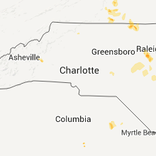
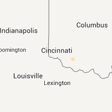
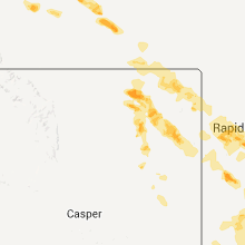
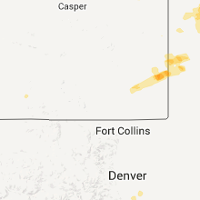
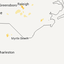
Hail Map for Wednesday, June 17, 2015

Number of Impacted Households on 6/17/2015
0
Impacted by 1" or Larger Hail
0
Impacted by 1.75" or Larger Hail
0
Impacted by 2.5" or Larger Hail
Square Miles of Populated Area Impacted on 6/17/2015
0
Impacted by 1" or Larger Hail
0
Impacted by 1.75" or Larger Hail
0
Impacted by 2.5" or Larger Hail


Cities Most Affected by Hail Storms of 6/17/2015
| Hail Size | Demographics of Zip Codes Affected | ||||||
|---|---|---|---|---|---|---|---|
| City | Count | Average | Largest | Pop Density | House Value | Income | Age |
| Broadus, MT | 2 | 2.38 | 2.75 | 0 | $58k | $27.8k | 49.9 |
| Yoder, WY | 2 | 2.25 | 2.50 | 1 | $66k | $30.4k | 49.6 |
| Scottsbluff, NE | 2 | 1.88 | 2.00 | 157 | $75k | $31.0k | 37.9 |
| Olive, MT | 2 | 1.75 | 1.75 | 0 | $58k | $36.5k | 42.5 |
| Rapid City, SD | 2 | 1.75 | 1.75 | 114 | $83k | $38.6k | 33.9 |
| Hot Springs, SD | 2 | 1.75 | 1.75 | 11 | $63k | $30.3k | 50.7 |
| Weston, WY | 1 | 2.00 | 2.00 | 0 | $30k | $53.9k | 47.9 |
| Lagrange, WY | 1 | 2.00 | 2.00 | 1 | $74k | $25.0k | 25.1 |
| Rozet, WY | 1 | 2.00 | 2.00 | 2 | $87k | $58.0k | 34.6 |
| Guyton, GA | 1 | 1.75 | 1.75 | 105 | $110k | $46.8k | 35.1 |
| Volborg, MT | 1 | 1.75 | 1.75 | 0 | $106k | $36.3k | 48.7 |
| Clarks Grove, MN | 1 | 1.75 | 1.75 | 21 | $70k | $40.5k | 39.8 |
| Milton, NC | 1 | 1.75 | 1.75 | 49 | $66k | $29.2k | 44.1 |
| Mitchell, NE | 1 | 1.75 | 1.75 | 12 | $70k | $33.1k | 43.4 |
Hail and Wind Damage Spotted on 6/17/2015
Filter by Report Type:Hail ReportsWind Reports
States Impacted
Texas, Nebraska, Minnesota, Louisiana, Georgia, North Carolina, Florida, Oklahoma, Indiana, Virginia, New Mexico, Arkansas, Kentucky, Wisconsin, Montana, South Carolina, Wyoming, West Virginia, Colorado, South Dakota, KansasTexas
| Local Time | Report Details |
|---|---|
| 10:00 AM CDT | Va clinic in lufkin without power - appointsments cancelled for the da in angelina county TX, 1.1 miles SW of Lufkin, TX |
| 6:16 PM CDT | Large tree branches blown down in bexar county TX, 16.2 miles N of San Antonio, TX |
| 7:06 PM CDT | Metal barn heavily damaged. time estimated from rada in bexar county TX, 16.6 miles E of San Antonio, TX |
| 7:49 PM CDT | 3 inch diameter tree limbs blown down in bexar county TX, 10.1 miles N of San Antonio, TX |
Nebraska
| Local Time | Report Details |
|---|---|
| 10:12 AM CDT | Ping Pong Ball sized hail reported near Hayes Center, NE, 33.5 miles SSW of North Platte, NE |
| 6:12 PM MDT | Golf Ball sized hail reported near Scottsbluff, NE, 0.6 miles NNE of Scottsbluff, NE |
| 6:13 PM MDT | Hen Egg sized hail reported near Scottsbluff, NE, 0.6 miles NNE of Scottsbluff, NE, relayed by law enforcement. hail was larger than golf ball sized. |
| 6:14 PM MDT | Ping Pong Ball sized hail reported near Scottsbluff, NE, 1.4 miles NNE of Scottsbluff, NE |
| 6:15 PM MDT | Ping Pong Ball sized hail reported near Morrill, NE, 14.9 miles WNW of Scottsbluff, NE |
| 6:24 PM MDT | Ping Pong Ball sized hail reported near Mitchell, NE, 14.4 miles NNW of Scottsbluff, NE |
| 6:25 PM MDT | Golf Ball sized hail reported near Mitchell, NE, 14.4 miles NNW of Scottsbluff, NE, reported on highway 29. |
| 7:52 PM MDT | Ping Pong Ball sized hail reported near Chadron, NE, 70.1 miles NNE of Scottsbluff, NE, reported at the chadron city dam. |
| 8:18 PM MDT | Quarter sized hail reported near Rushville, NE, 88.1 miles SSE of Rapid City, SD, lots of dime size hail with some quarters. |
| 8:20 PM MDT | Half Dollar sized hail reported near Chadron, NE, 65.3 miles NNE of Scottsbluff, NE |
| 8:37 PM MDT | Quarter sized hail reported near Rushville, NE, 88 miles NE of Scottsbluff, NE |
Minnesota
| Local Time | Report Details |
|---|---|
| 12:45 PM CDT | Home had a couple of large cedars knocked down and a large wooden swing set blown ove in waseca county MN, 57.2 miles SSW of Minneapolis, MN |
| 3:12 PM CDT | Trees reported down by i-35 at mile marker 2 in steele county MN, 51.6 miles N of Mason City, IA |
| 4:39 PM CDT | Golf Ball sized hail reported near Clarks Grove, MN, 42.8 miles N of Mason City, IA, picture of golf ball sized hail relayed by local media. |
Louisiana
| Local Time | Report Details |
|---|---|
| 1:19 PM CDT | Tree down on 3049 near blanchard mobile and tree down on blanchard furr road in caddo county LA, 12.5 miles NW of Shreveport, LA |
| 2:23 PM CDT | Trees down on emma cemetery roa in bossier county LA, 28.7 miles NNE of Shreveport, LA |
| 2:27 PM CDT | Trees down on salem cemetery r in bossier county LA, 29.6 miles NNE of Shreveport, LA |
Georgia
| Local Time | Report Details |
|---|---|
| 3:29 PM EDT | 2 trees blown down in stockton in lanier county GA, 40 miles SSW of Douglas, GA |
| 4:11 PM EDT | The public relayed a picture of a large tree blown down in the horsecreek farms subdivision. time estimated based on rada in long county GA, 39.7 miles WSW of Savannah, GA |
| 4:17 PM EDT | Tree limbs down on hwy 196w at zorn r in liberty county GA, 39 miles WSW of Savannah, GA |
| 4:46 PM EDT | Emergency manager reports several trees down just off/very near highway 165 near the border of laurens county and dodge count in laurens county GA, 51.3 miles N of Douglas, GA |
| 4:54 PM EDT | Dispatch reported numerous trees and powerlines downed countywid in pierce county GA, 39.5 miles ESE of Douglas, GA |
| 4:55 PM EDT | Dispatch reported 2 trees down in the jesup city limit in wayne county GA, 57.1 miles E of Douglas, GA |
| 4:55 PM EDT | Media reported via social media a tree downed on powerline in wayne county GA, 54.9 miles E of Douglas, GA |
| 5:06 PM EDT | Media reported two flag poles snapped at the douglas courthous in coffee county GA, 1.1 miles S of Douglas, GA |
| 5:06 PM EDT | Spotter reported a tree downed blocking walker street and several powerlines downe in coffee county GA, 1 miles N of Douglas, GA |
| 5:06 PM EDT | Em reported a roof blown off of a structure along with several trees and power lines downed within the city limit in coffee county GA, 0.3 miles N of Douglas, GA |
| 5:12 PM EDT | Golf Ball sized hail reported near Guyton, GA, 20.6 miles NW of Savannah, GA, golfball sized hail reported at the intersection of courthouse rd with hwy 17n. |
| 5:12 PM EDT | Tree down reported at the intersection of courthouse rd with hwy 17 in effingham county GA, 20.6 miles NW of Savannah, GA |
| 5:18 PM EDT | Tree down on highway 8 in thomas county GA, 37.9 miles NE of Tallahassee, FL |
| 5:20 PM EDT | Emergency manager reports numerous trees down....between 25-50...within the city limits of dublin. several structural fires were also generated...most likely from light in laurens county GA, 71.3 miles N of Douglas, GA |
| 5:30 PM EDT | Dipatch reported numerous trees and power lines downed countywid in pierce county GA, 41.3 miles ESE of Douglas, GA |
| 5:30 PM EDT | Tree down oncoffee road near patton speedwa in thomas county GA, 40.5 miles NE of Tallahassee, FL |
| 5:40 PM EDT | Emergency manager reported 2 barns blown down just southeast of alama near caraway road. the time given was based on rada in bacon county GA, 23.6 miles E of Douglas, GA |
| 5:45 PM EDT | The emergency management reported numerous trees and powerlines down in alma. the time given was based on rada in bacon county GA, 21.9 miles E of Douglas, GA |
| 6:00 PM EDT | 911 call center recieved report of several trees down on wommack-brantley road in harriso in washington county GA, 62.6 miles SW of Augusta, GA |
| 6:23 PM EDT | Jeff davis county emergency manager reported a small tree down on a home on taylor road with minor damage to the hom in jeff davis county GA, 19 miles NE of Douglas, GA |
| 6:24 PM EDT | Dispatch reported several trees and powerlines downed in the southern part of the count in jeff davis county GA, 17.2 miles NNE of Douglas, GA |
| 6:30 PM EDT | An abandoned building in rebecca collapsed on three sides due to strong winds in turner county GA, 43.2 miles WNW of Douglas, GA |
| 6:30 PM EDT | Several trees down around the count in grady county GA, 30.6 miles N of Tallahassee, FL |
| 6:35 PM EDT | Jeff davis emergency manager reported a tree down on a home on alabama street in denton. other trees were also down in the area with nickel sized hail reporte in jeff davis county GA, 17.2 miles NNE of Douglas, GA |
| 6:50 PM EDT | Tree down resulting in a power outage in northwest tift county in the area of little river road in tift county GA, 46.2 miles W of Douglas, GA |
| 7:05 PM EDT | Tree down causing a power outage in sycamore in turner county GA, 48 miles WNW of Douglas, GA |
| 7:10 PM EDT | At least 7 trees down across rural turner county in turner county GA, 47.8 miles WNW of Douglas, GA |
| 7:24 PM EDT | Tree down on highway 65 in mitchell county GA, 48.3 miles N of Tallahassee, FL |
| 7:35 PM EDT | Tree down across the road near 2501 jerusalem church road in mitchell county GA, 60.2 miles N of Tallahassee, FL |
| 7:45 PM EDT | Many trees and power lines down across the count in worth county GA, 58.5 miles W of Douglas, GA |
| 7:50 PM EDT | Local sheriff office in dooly county received report of at least 5 trees down across the count in dooly county GA, 71.8 miles NW of Douglas, GA |
| 8:00 PM EDT | Several trees and power lines down near baconton in mitchell county GA, 65.2 miles N of Tallahassee, FL |
| 8:15 PM EDT | Tree down near intersection of corn road and madison road in dougherty county GA, 77.5 miles W of Douglas, GA |
| 8:20 PM EDT | Tree down at hilltop road and 11th street in dougherty county GA, 79.3 miles W of Douglas, GA |
| 8:25 PM EDT | Tree down near 2500 doublegate dr in dougherty county GA, 79.9 miles N of Tallahassee, FL |
| 8:25 PM EDT | Tree down near intersection of old dawson road and doublegate road in dougherty county GA, 80.6 miles N of Tallahassee, FL |
| 8:40 PM EDT | Trees down on sasser-herod road in terrell county GA, 87.7 miles N of Tallahassee, FL |
North Carolina
| Local Time | Report Details |
|---|---|
| 3:52 PM EDT | Tree blown down at emergency management center at south gordon and east court streets. time estimated by rada in mcdowell county NC, 64 miles S of Bristol, TN |
| 4:00 PM EDT | Trees and power lines down at intersection of school street and virginia roa in mcdowell county NC, 62.7 miles SSE of Bristol, TN |
| 4:21 PM EDT | Quarter sized hail reported near Marion, NC, 64 miles S of Bristol, TN |
| 4:23 PM EDT | Quarter sized hail reported near Marion, NC, 64 miles S of Bristol, TN |
| 4:38 PM EDT | Quarter sized hail reported near Marion, NC, 65.9 miles SSE of Bristol, TN, volunteer fire fighter reports quarter sized hail at the loves travel stop at exit 86 off interstate 40. |
| 5:00 PM EDT | Power line down on twin oaks road near zephyr rd in surry county NC, 76.6 miles SW of Roanoke, VA |
| 6:05 PM EDT | Large tree down on island creek roa in jones county NC, 67.6 miles NE of Wilmington, NC |
| 7:25 PM EDT | Many trees and power lines blown down in and around the campus of western carolina universit in jackson county NC, 46.6 miles NW of Greenville, SC |
| 7:54 PM EDT | Numerous trees were reported down across the road and on houses along morton pulliam road between semora road and jack hambrick roa in person county NC, 49.9 miles NNW of Raleigh, NC |
| 10:23 PM EDT | Tree down on a house. 100 block of honeysuckle lane in wake county NC, 9.4 miles W of Raleigh, NC |
| 10:30 PM EDT | Tree down on powelines on chapel hill rd at sorrell st. report from wral traffi in wake county NC, 7.2 miles W of Raleigh, NC |
| 10:38 PM EDT | Half Dollar sized hail reported near Cary, NC, 6.3 miles WSW of Raleigh, NC, half dollar size hail possibly some larger was reported near the interchange of us highway 1 and walnut st. |
| 10:45 PM EDT | Quarter sized hail reported near Raleigh, NC, 1.6 miles WSW of Raleigh, NC, nc state campus. lasted about 15 minutes. |
| 11:30 PM EDT | Several powerlines down around angie in harnett county NC, 19.8 miles SSW of Raleigh, NC |
| 11:50 PM EDT | Trees down in sanford. one tree blocking the ems garag in lee county NC, 36.9 miles SW of Raleigh, NC |
| 11:57 PM EDT | Quarter sized hail reported near Milton, NC, 60.9 miles NNW of Raleigh, NC |
| 12:00 AM EDT | Several reports of trees down in several places in milton. time estimated by rada in caswell county NC, 60.9 miles NNW of Raleigh, NC |
| 12:00 AM EDT | Golf Ball sized hail reported near Milton, NC, 60.9 miles NNW of Raleigh, NC, along main st in milton. time estimated by radar |
| 12:03 AM EDT | Trees down in sanford. one tree blocking the ems garag in lee county NC, 36.9 miles SW of Raleigh, NC |
| 12:30 AM EDT | Several powerlines down around angie in harnett county NC, 19.8 miles SSW of Raleigh, NC |
| 12:35 AM EDT | Tree down. report from wral traffi in harnett county NC, 20.3 miles SSW of Raleigh, NC |
Florida
| Local Time | Report Details |
|---|---|
| 4:10 PM EDT | Tree down near intersection of little cat road and farm center road in madison county FL, 48.3 miles E of Tallahassee, FL |
| 4:29 PM EDT | Tree down on lovett road in madison county FL, 43.1 miles E of Tallahassee, FL |
| 4:56 PM EDT | Tree down at 9676 asheville highwa in jefferson county FL, 35.8 miles ENE of Tallahassee, FL |
| 5:00 PM EDT | Tree down on cherry tree roa in jefferson county FL, 17.4 miles E of Tallahassee, FL |
| 5:00 PM EDT | Tree down on government farm roa in jefferson county FL, 33.5 miles ENE of Tallahassee, FL |
| 5:22 PM EDT | Tree down on the boston highwa in jefferson county FL, 28.8 miles ENE of Tallahassee, FL |
| 5:45 PM EDT | Tree down blocking the roa in leon county FL, 17.9 miles NE of Tallahassee, FL |
| 6:00 PM EDT | Tree down on a power line and blocking a road. corrected time of event in leon county FL, 14.7 miles NNE of Tallahassee, FL |
| 6:05 PM EDT | Power line down in road blocking traffi in leon county FL, 15.9 miles NNE of Tallahassee, FL |
| 6:10 PM EDT | Power line draped over a roa in leon county FL, 15.9 miles N of Tallahassee, FL |
| 6:30 PM EDT | Tree down on a power line and blocking a roa in leon county FL, 14.7 miles NNE of Tallahassee, FL |
Oklahoma
| Local Time | Report Details |
|---|---|
| 3:33 PM CDT | Tfew trees reported down and power out in pollard area in mccurtain county OK, 49.4 miles W of Nashville, AR |
| 3:35 PM CDT | Several trees down and power out in the bokhoma area in mccurtain county OK, 45 miles WSW of Nashville, AR |
Indiana
| Local Time | Report Details |
|---|---|
| 4:38 PM EDT | Large tree limb dow in clark county IN, 21.5 miles N of Louisville, KY |
Virginia
| Local Time | Report Details |
|---|---|
| 4:52 PM EDT | 3 trees snapped along baldwin ave in roanoke cit in roanoke county VA, 1.3 miles ENE of Roanoke, VA |
| 4:56 PM EDT | Tree down near eastgate and yeager ave in city of roanoke county VA, 1.7 miles NE of Roanoke, VA |
| 5:00 PM EDT | Tree down and some damage to home and fence on dunkirk ave in city of roanoke county VA, 2.6 miles ENE of Roanoke, VA |
| 5:00 PM EDT | Tree down on vale ave in roanoke county VA, 1.8 miles ENE of Roanoke, VA |
| 5:16 PM EDT | Tree down on pepper road in franklin county VA, 20.1 miles S of Roanoke, VA |
| 5:30 PM EDT | Tree down on ball park road in franklin county VA, 20.2 miles SSE of Roanoke, VA |
| 5:36 PM EDT | Quarter sized hail reported near Wirtz, VA, 16.9 miles SE of Roanoke, VA, quarter sized hail fell for a three minute period. |
| 5:38 PM EDT | Tree down on lovely valley road in franklin county VA, 18.7 miles SE of Roanoke, VA |
| 5:45 PM EDT | Two trees down on blue water drive in franklin county VA, 20.3 miles SE of Roanoke, VA |
| 5:53 PM EDT | Two trees down on ashmead road near scruggs road in franklin county VA, 22.9 miles SE of Roanoke, VA |
| 6:01 PM EDT | Tree down on smith mount roa in pittsylvania county VA, 32.9 miles SSE of Roanoke, VA |
| 6:29 PM EDT | Tree uprooted on oxford r in pittsylvania county VA, 34.6 miles SE of Roanoke, VA |
| 6:34 PM EDT | One tree down near the 8800 block of the franklin turnpik in pittsylvania county VA, 46.7 miles SE of Roanoke, VA |
| 6:37 PM EDT | Tree down on franklin turnpike and cedar ridge r in pittsylvania county VA, 42.9 miles SSE of Roanoke, VA |
| 6:37 PM EDT | Tree down on longview drive in henry county VA, 39.4 miles S of Roanoke, VA |
| 6:38 PM EDT | Tree down on stultz road and virginia avenue in henry county VA, 39.5 miles S of Roanoke, VA |
| 6:39 PM EDT | Tree down along franklin turnpik in pittsylvania county VA, 45.5 miles SSE of Roanoke, VA |
| 6:39 PM EDT | Quarter sized hail reported near Bassett, VA, 36.7 miles S of Roanoke, VA, quarter sized hail |
| 6:47 PM EDT | Quarter sized hail reported near Martinsville, VA, 39.8 miles S of Roanoke, VA, quarter sized hail fell along owens rd in martinsville |
| 6:56 PM EDT | Tree uprooted on twin arch drive in pittsylvania county VA, 53.8 miles SE of Roanoke, VA |
| 6:58 PM EDT | Tree down at intersection of kentuck rd and burch creek r in pittsylvania county VA, 56.2 miles SE of Roanoke, VA |
| 10:00 PM EDT | Tree down near 2400 block of julia simpkins roa in pulaski county VA, 47.3 miles WSW of Roanoke, VA |
| 10:24 PM EDT | Several trees down along rte 8. time estimated by rada in montgomery county VA, 31.9 miles WSW of Roanoke, VA |
New Mexico
| Local Time | Report Details |
|---|---|
| 3:10 PM MDT | Quarter sized hail reported near Raton, NM, 76.3 miles ENE of Taos, NM, mostly dime size...few up to quarter size. |
| 5:27 PM MDT | Quarter sized hail reported near La Luz, NM, 86.9 miles WSW of Roswell, NM |
Arkansas
| Local Time | Report Details |
|---|---|
| 4:19 PM CDT | Trees were blown down in clark county AR, 40.5 miles ENE of Nashville, AR |
Kentucky
| Local Time | Report Details |
|---|---|
| 5:32 PM EDT | Large tree limb down in valley statio in jefferson county KY, 11 miles NW of Louisville, KY |
| 5:35 PM EDT | Multiple large limbs dow in jefferson county KY, 13.3 miles NNW of Louisville, KY |
| 5:40 PM EDT | Large tree limb dow in jefferson county KY, 8.8 miles NNW of Louisville, KY |
| 5:46 PM EDT | Tree blocking road at 9600 preston highwa in jefferson county KY, 8.8 miles NNE of Louisville, KY |
Wisconsin
| Local Time | Report Details |
|---|---|
| 5:30 PM CDT | Greenhouse and trees damaged. reported via county dispatc in polk county WI, 46.5 miles ENE of Minneapolis, MN |
Montana
| Local Time | Report Details |
|---|---|
| 4:35 PM MDT | Lasted 5 minutes until 440 p in valley county MT, 1.6 miles NE of Glasgow, MT |
| 5:10 PM MDT | Reports of a few power poles snapped by thunderstorm winds. time based on radar velocity data in that locatio in valley county MT, 29.6 miles NNE of Glasgow, MT |
| 5:50 PM MDT | Quarter sized hail reported near Forsyth, MT, 36.6 miles SW of Miles City, MT, quarter size hail with heavy rain and 35 mph winds. |
| 6:20 PM MDT | Ping Pong Ball sized hail reported near Volborg, MT, 53.8 miles S of Miles City, MT, hail lasted about 40 minutes. |
| 6:30 PM MDT | Golf Ball sized hail reported near Volborg, MT, 50.9 miles S of Miles City, MT, golf-ball size hail occurred for the last 15 minutes. |
| 6:30 PM MDT | Ping Pong Ball sized hail reported near Volborg, MT, 53.8 miles S of Miles City, MT, hail lasted about 40 minutes. |
| 7:00 PM MDT | Golf Ball sized hail reported near Olive, MT, 60.5 miles SSE of Miles City, MT, spotter reported golf ball hail at mile marker 70 on hwy 212. |
| 7:00 PM MDT | Golf Ball sized hail reported near Olive, MT, 59.7 miles SSE of Miles City, MT |
| 7:15 PM MDT | Baseball sized hail reported near Broadus, MT, 68.2 miles SSE of Miles City, MT, hail up to the size of baseballs. spotters car window broken. |
| 7:30 PM MDT | Hen Egg sized hail reported near Broadus, MT, 75.1 miles N of Gillette, WY |
South Carolina
| Local Time | Report Details |
|---|---|
| 6:40 PM EDT | Trained spotter reported 2'' thick branches down 8 miles north of bowman. report relayed via twitte in orangeburg county SC, 42.7 miles WNW of Charleston, SC |
| 7:20 PM EDT | Quarter sized hail reported near Cameron, SC, 45.8 miles WNW of Charleston, SC, trained spotter reported 1'' hail 2 miles se of cameron. report relayed via twitter. |
| 7:27 PM EDT | Highway patrol reported tree in roadway on cameron roa in calhoun county SC, 47.2 miles NW of Charleston, SC |
| 7:47 PM EDT | Tree down jordanville road in horry county SC, 68.2 miles NE of Charleston, SC |
| 8:30 PM EDT | Several trees and power lines snapped on bud graham road in horry county SC, 73.2 miles W of Wilmington, NC |
| 9:35 PM EDT | Tree in roadway. lynch road and u.s. 52 in florence county SC, 55.4 miles NNE of Charleston, SC |
Wyoming
| Local Time | Report Details |
|---|---|
| 5:12 PM MDT | Hen Egg sized hail reported near Lagrange, WY, 33.5 miles WSW of Scottsbluff, NE, via live storm chaser video. time and location estimated based on radar. |
| 5:40 PM MDT | Ping Pong Ball sized hail reported near Yoder, WY, 35 miles W of Scottsbluff, NE |
| 5:40 PM MDT | Tennis Ball sized hail reported near Yoder, WY, 32.6 miles W of Scottsbluff, NE |
| 5:50 PM MDT | Ping Pong Ball sized hail reported near Torrington, WY, 22.4 miles W of Scottsbluff, NE |
| 5:50 PM MDT | Hen Egg sized hail reported near Yoder, WY, 31.5 miles W of Scottsbluff, NE |
| 7:56 PM MDT | Storm damage reported in campbell county WY, 50.4 miles NNE of Gillette, WY |
| 7:59 PM MDT | Storm damage reported in campbell county WY, 50.4 miles NNE of Gillette, WY |
| 8:15 PM MDT | Hen Egg sized hail reported near Weston, WY, 25.2 miles NNE of Gillette, WY |
| 8:16 PM MDT | Ping Pong Ball sized hail reported near Weston, WY, 28.7 miles NNE of Gillette, WY |
| 8:16 PM MDT | Storm damage reported in campbell county WY, 28.7 miles NNE of Gillette, WY |
| 8:40 PM MDT | Some tree damage in tow in crook county WY, 52.1 miles ENE of Gillette, WY |
| 8:45 PM MDT | Storm damage reported in crook county WY, 56.4 miles ENE of Gillette, WY |
| 8:45 PM MDT | Quarter sized hail reported near Alva, WY, 56.4 miles ENE of Gillette, WY |
| 9:25 PM MDT | Quarter sized hail reported near Moorcroft, WY, 35.2 miles E of Gillette, WY, hail covering ground |
| 9:44 PM MDT | Hen Egg sized hail reported near Rozet, WY, 18.4 miles ESE of Gillette, WY, also had 60mph wind gusts |
| 10:15 PM MDT | Storm damage reported in weston county WY, 55.6 miles WSW of Rapid City, SD |
| 10:23 PM MDT | Quarter sized hail reported near , , 39.8 miles SSE of Gillette, WY |
West Virginia
| Local Time | Report Details |
|---|---|
| 7:15 PM EDT | Viewer provided pictures to local media of damage to their mobile home and trees on their property. time is estimate in upshur county WV, 19.8 miles W of Elkins, WV |
| 7:15 PM EDT | Viewer provided pictures to local media of damage to their mobile home and trees on their property. time is estimated. damage occurred on tallmansville roa in upshur county WV, 15.5 miles WSW of Elkins, WV |
Colorado
| Local Time | Report Details |
|---|---|
| 5:28 PM MDT | Quarter sized hail reported near Parker, CO, 17.4 miles SE of Denver, CO |
| 5:43 PM MDT | Ping Pong Ball sized hail reported near Aurora, CO, 20 miles ESE of Denver, CO |
South Dakota
| Local Time | Report Details |
|---|---|
| 5:45 PM MDT | Quarter sized hail reported near Rapid City, SD, 0.5 miles W of Rapid City, SD |
| 5:45 PM MDT | Quarter sized hail reported near Rapid City, SD, 1.7 miles SSW of Rapid City, SD |
| 5:50 PM MDT | Ping Pong Ball sized hail reported near Rapid City, SD, 4.2 miles WSW of Rapid City, SD, report from nssl shave project |
| 6:17 PM MDT | Quarter sized hail reported near Rapid City, SD, 6.8 miles SSE of Rapid City, SD, hail covering roads |
| 6:17 PM MDT | Golf Ball sized hail reported near Rapid City, SD, 7 miles SSE of Rapid City, SD |
| 6:20 PM MDT | Golf Ball sized hail reported near Rapid City, SD, 7 miles SSE of Rapid City, SD, hail lasted 10-15 minutes. mainly quarters with a few golf balls. |
| 10:35 PM MDT | Quarter sized hail reported near Rapid City, SD, 13.1 miles WSW of Rapid City, SD |
| 10:49 PM MDT | Storm damage reported in pennington county SD, 4.2 miles S of Rapid City, SD |
| 10:50 PM MDT | Half Dollar sized hail reported near Rapid City, SD, 2 miles E of Rapid City, SD |
| 10:52 PM MDT | Ping Pong Ball sized hail reported near Rapid City, SD, 2.2 miles ESE of Rapid City, SD |
| 11:30 PM MDT | Golf Ball sized hail reported near Hot Springs, SD, 45.3 miles SSW of Rapid City, SD, report relayed via twitter |
| 11:30 PM MDT | Golf Ball sized hail reported near Hot Springs, SD, 40.7 miles SSW of Rapid City, SD, report relayed via twitter |
| 12:12 AM MDT | Storm damage reported in shannon county SD, 67.1 miles SSE of Rapid City, SD |
| 12:22 AM MDT | Storm damage reported in shannon county SD, 67.1 miles SSE of Rapid City, SD |
| 12:30 AM MDT | Storm damage reported in shannon county SD, 72.6 miles SE of Rapid City, SD |
| 12:33 AM MDT | Storm damage reported in shannon county SD, 81.7 miles SSE of Rapid City, SD |
| 12:41 AM MDT | Storm damage reported in shannon county SD, 72.8 miles SE of Rapid City, SD |
Kansas
| Local Time | Report Details |
|---|---|
| 7:05 PM CDT | Quarter sized hail reported near Collyer, KS, 42.3 miles WNW of Hays, KS |
| 7:28 PM CDT | Quarter sized hail reported near Collyer, KS, 43.1 miles W of Hays, KS |
Connect with Interactive Hail Maps