

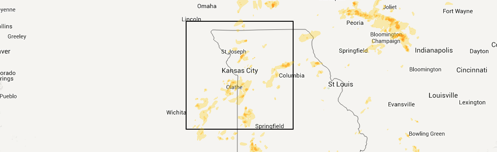
Hail Map for Sunday, May 6, 2012
Number of Impacted Households on 5/6/2012
0
Impacted by 1" or Larger Hail
0
Impacted by 1.75" or Larger Hail
0
Impacted by 2.5" or Larger Hail
Square Miles of Populated Area Impacted on 5/6/2012
0
Impacted by 1" or Larger Hail
0
Impacted by 1.75" or Larger Hail
0
Impacted by 2.5" or Larger Hail


Cities Most Affected by Hail Storms of 5/6/2012
| Hail Size | Demographics of Zip Codes Affected | ||||||
|---|---|---|---|---|---|---|---|
| City | Count | Average | Largest | Pop Density | House Value | Income | Age |
| Hoopeston, IL | 3 | 2.25 | 2.50 | 53 | $51k | $32.8k | 41.7 |
| Llano, TX | 2 | 1.88 | 2.00 | 10 | $85k | $35.8k | 51.0 |
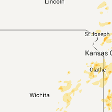
| Olathe, KS | 2 | 1.75 | 1.75 | 886 | $124k | $52.8k | 33.4 |
| Vaiden, MS | 2 | 1.75 | 1.75 | 14 | $50k | $22.2k | 43.5 |
| Brundidge, AL | 1 | 3.00 | 3.00 | 39 | $53k | $20.3k | 44.5 |
| Stewartsville, MO | 1 | 2.75 | 2.75 | 20 | $74k | $35.8k | 44.0 |
| Clifton, IL | 1 | 2.75 | 2.75 | 16 | $98k | $45.7k | 40.6 |
| Tiskilwa, IL | 1 | 1.75 | 1.75 | 14 | $82k | $39.2k | 44.5 |
| Cedartown, GA | 1 | 1.75 | 1.75 | 135 | $74k | $31.8k | 35.3 |
| Nevada, MO | 1 | 1.75 | 1.75 | 91 | $65k | $30.9k | 40.0 |
| Midway, AL | 1 | 1.75 | 1.75 | 6 | $43k | $17.6k | 43.5 |
| Oxford, WI | 1 | 1.75 | 1.75 | 37 | $86k | $37.0k | 40.8 |
| Henry, IL | 1 | 1.75 | 1.75 | 48 | $72k | $41.2k | 43.6 |
| London, TX | 1 | 1.75 | 1.75 | 2 | $23k | $21.6k | 57.6 |
| Chebanse, IL | 1 | 1.75 | 1.75 | 38 | $99k | $43.0k | 40.4 |
| Herscher, IL | 1 | 1.75 | 1.75 | 28 | $114k | $50.0k | 38.6 |
| Menard, TX | 1 | 1.75 | 1.75 | 1 | $30k | $23.1k | 49.4 |
| Maysville, MO | 1 | 1.75 | 1.75 | 15 | $53k | $31.0k | 39.9 |
Hail and Wind Damage Spotted on 5/6/2012
Filter by Report Type:Hail ReportsWind Reports
States Impacted
Alabama, Iowa, Wisconsin, Missouri, Georgia, Illinois, Mississippi, Florida, Kansas, Tennessee, Texas, Indiana, ArkansasAlabama
| Local Time | Report Details |
|---|---|
| 7:00 AM CDT | One tree down in a driveway. approximately 8-12 inches in dia in talladega county AL, 41.7 miles E of Birmingham, AL |
| 9:50 AM CDT | Quarter sized hail reported near Five Points, AL, 35.2 miles NNE of Auburn, AL |
| 10:28 AM CDT | Quarter sized hail reported near Autaugaville, AL, 47.7 miles NE of Camden, AL, quarter size hail just west of autaugaville along highway 14. |
| 11:55 AM CDT | Quarter sized hail reported near Minter, AL, 16.7 miles ENE of Camden, AL, quarter size hail briefly covered the ground. |
| 12:36 PM CDT | Tea Cup sized hail reported near Brundidge, AL, 69.4 miles SSW of Auburn, AL, us 231 |
| 1:02 PM CDT | Quarter sized hail reported near Goshen, AL, 70.8 miles ESE of Camden, AL |
| 1:03 PM CDT | A few trees were blown down along county road 79 near come in barbour county AL, 42.5 miles SSE of Auburn, AL |
| 1:13 PM CDT | Tree down along county road 59...north of county road 3 in dale county AL, 77.7 miles S of Auburn, AL |
| 1:30 PM CDT | Thunderstorm winds pushed large tree on house. extensive damag in clarke county AL, 48.6 miles WSW of Camden, AL |
| 1:30 PM CDT | Golf Ball sized hail reported near Midway, AL, 43.3 miles S of Auburn, AL |
| 1:34 PM CDT | Ping Pong Ball sized hail reported near Ozark, AL, 81.4 miles NNE of Miramar Beach, FL, hail up to 1.5 inches now falling near logan rd. |
| 1:58 PM CDT | Tree down on a power line at the 300 block of valley stream driv in coffee county AL, 73.7 miles NNE of Miramar Beach, FL |
| 1:59 PM CDT | Quarter sized hail reported near Headland, AL, 87 miles S of Auburn, AL, picture on facebook of estimated quarter size hail around headland. |
| 5:47 PM CDT | Quarter sized hail reported near Haleyville, AL, 38 miles S of Florence, AL, large tree down on a fence as well. |
| 5:50 PM CDT | Winds were estimated at or just greater than 60 mph for about one minut in winston county AL, 38.8 miles S of Florence, AL |
| 5:50 PM CDT | Winds were estimated at or just greater than 60 mph for about one minute. power lines are down throughout the city and several roads are closed due to the power lines b in winston county AL, 38.8 miles S of Florence, AL |
| 5:50 PM CDT | 15th ave severe home damage from fallen tre in winston county AL, 38.8 miles S of Florence, AL |
| 5:50 PM CDT | Quarter sized hail reported near Nauvoo, AL, 49.2 miles NW of Birmingham, AL |
| 6:03 PM CDT | Quarter sized hail reported near Bessemer, AL, 15.7 miles W of Birmingham, AL, quarter size hail at hillview drive in rock creek. |
| 6:33 PM CDT | A tree was knocked down at the 4500 block of county road 22 in spruce pin in franklin county AL, 29 miles SSW of Florence, AL |
| 7:09 PM CDT | Quarter sized hail reported near Oakman, AL, 35.8 miles WNW of Birmingham, AL |
| 7:12 PM CDT | Several trees blown down in oakma in walker county AL, 35.8 miles WNW of Birmingham, AL |
| 7:37 PM CDT | Tree reported blown down along hwy 18 eas in fayette county AL, 49.9 miles WNW of Birmingham, AL |
| 11:15 PM CDT | A tree was knocked down causing a power outage at the intersection of scout hollow road and wilson road. called in at 11 in franklin county AL, 25.3 miles SSW of Florence, AL |
| 11:32 PM CDT | A tree was knocked down at 1044 highway 62 in franklin county AL, 21.9 miles SSW of Florence, AL |
| 11:32 PM CDT | Power was knocked out at the 911 center in belgree in franklin county AL, 25.3 miles SSW of Florence, AL |
Iowa
| Local Time | Report Details |
|---|---|
| 7:05 AM CDT | Measured by kcci schoolnet site at nodaway valley schoo in adair county IA, 53.7 miles WSW of Des Moines, IA |
| 7:23 AM CDT | Also measured a 73 mph gust at 726 a in adair county IA, 40.4 miles WSW of Des Moines, IA |
| 7:37 AM CDT | Quarter sized hail reported near Riceville, IA, 39.2 miles ENE of Mason City, IA, trained spotter reported quarter size hail seven miles west of oxford near the intersection of county road b and highway 82 |
| 7:40 AM CDT | Five to six 8 inch in diameter tree limbs down across town. time estimated by rada in dallas county IA, 34.1 miles W of Des Moines, IA |
| 7:55 AM CDT | One half of a tree snapped off. section of tree was one foot in diameter. neighbor who observed the winds estimated the wind speed to be between 55 and 60 mp in dallas county IA, 25.3 miles WNW of Des Moines, IA |
| 8:19 AM CDT | Some shingles blown off roof...winds estimated between 65 and 70 mp in warren county IA, 9.1 miles SSW of Des Moines, IA |
| 8:32 AM CDT | Delayed report corrected in dallas county IA, 17.3 miles WNW of Des Moines, IA |
| 8:50 AM CDT | Two power line poles snapped off at the base. time estimated from rada in story county IA, 30.1 miles NNE of Des Moines, IA |
Wisconsin
| Local Time | Report Details |
|---|---|
| 7:37 AM CDT | Quarter sized hail reported near Oxford, WI, 51.1 miles NNW of Madison, WI, trained spotter reported quarter size hail seven miles west of oxford near the intersection of county road b and highway 82 |
| 7:39 AM CDT | Golf Ball sized hail reported near Oxford, WI, 51.1 miles NNW of Madison, WI, trained spotter reported golf ball size hail near the intersection of highway 82 and county road b |
| 8:42 AM CDT | Quarter sized hail reported near Livingston, WI, 59.2 miles WSW of Madison, WI |
| 8:48 AM CDT | Quarter sized hail reported near Pardeeville, WI, 33.2 miles N of Madison, WI |
| 9:04 AM CDT | 10 inch diameter tree reported dow in columbia county WI, 32.2 miles NNE of Madison, WI |
| 9:45 AM CDT | Quarter sized hail reported near Edgerton, WI, 22.7 miles SE of Madison, WI |
| 9:57 AM CDT | Quarter sized hail reported near Janesville, WI, 32.9 miles SE of Madison, WI, on the southwest side of town. also...minor street flooding about the depth of the curb. |
| 12:16 PM CDT | Storm damage reported in waukesha county WI, 54.9 miles ESE of Madison, WI |
Missouri
| Local Time | Report Details |
|---|---|
| 9:45 AM CDT | Estimated 60-70 mph wind in caldwell county MO, 53.9 miles NE of Kansas City, MO |
| 12:39 PM CDT | Baseball sized hail reported near Stewartsville, MO, 44.9 miles N of Kansas City, MO, fire dept trained spotter reporting baseball size hail via sherrifs dept. |
| 12:57 PM CDT | Golf Ball sized hail reported near Maysville, MO, 55.6 miles NNE of Kansas City, MO, golfball size hail reported by trained spotter |
| 12:59 PM CDT | Quarter sized hail reported near Maysville, MO, 55.6 miles NNE of Kansas City, MO |
| 2:15 PM CDT | 3 inch limbs down in randolph county MO, 31.9 miles N of Columbia, MO |
| 2:15 PM CDT | Thunderstorm wind gusts estimated up to 6 in randolph county MO, 32.8 miles N of Columbia, MO |
| 2:16 PM CDT | Quarter sized hail reported near Washburn, MO, 58 miles SW of Springfield, MO |
| 2:20 PM CDT | The moberly awos reported a 58 mph wind gust. time estd as ob does not give exact time of gusts in randolph county MO, 32.8 miles N of Columbia, MO |
| 2:53 PM CDT | Storm damage reported in barry county MO, 42 miles SW of Springfield, MO |
| 2:59 PM CDT | The moberly awos reported a 58 mph wind gus in randolph county MO, 32.8 miles N of Columbia, MO |
| 3:08 PM CDT | Quarter sized hail reported near Paris, MO, 40.6 miles NNE of Columbia, MO |
| 3:30 PM CDT | Quarter sized hail reported near Reeds Spring, MO, 40.4 miles S of Springfield, MO |
| 3:45 PM CDT | Quarter sized hail reported near Monroe City, MO, 53.4 miles S of Kahoka, MO, wind gust est 40-50 mph |
| 4:38 PM CDT | Quarter sized hail reported near Nevada, MO, 60.7 miles E of Chanute, KS |
| 4:42 PM CDT | Golf Ball sized hail reported near Nevada, MO, 61.3 miles E of Chanute, KS |
| 4:45 PM CDT | Storm damage reported in vernon county MO, 61.3 miles E of Chanute, KS |
| 4:55 PM CDT | Large elm tree and powerline dow in vernon county MO, 61.3 miles E of Chanute, KS |
| 5:31 PM CDT | Quarter sized hail reported near Raymore, MO, 22.1 miles SSE of Kansas City, MO, quarter size hail reported in downtown raymore. |
| 5:41 PM CDT | Quarter sized hail reported near Raymore, MO, 22.1 miles SSE of Kansas City, MO |
| 5:48 PM CDT | Quarter sized hail reported near Greenwood, MO, 21.8 miles SE of Kansas City, MO, reported by retired nws employee. |
| 5:55 PM CDT | Quarter sized hail reported near Archie, MO, 43 miles SSE of Kansas City, MO |
| 6:45 PM CDT | Quarter sized hail reported near Harrisonville, MO, 33.9 miles SSE of Kansas City, MO |
Georgia
| Local Time | Report Details |
|---|---|
| 10:50 AM EDT | Quarter sized hail reported near Franklin, GA, 51.4 miles NNE of Auburn, AL, hail the size of quarters reported at the family dollar store in franklin. |
| 12:30 PM EDT | Quarter sized hail reported near Midland, GA, 38.7 miles E of Auburn, AL, broadcast media reported dime to quarter sized hail in midland. |
| 12:40 PM EDT | The 911 call center in harris county indicated a tree was reported down on the east side of hamilto in harris county GA, 37.7 miles ENE of Auburn, AL |
| 2:00 PM EDT | Sheriffs deputy of schley county reported 3 trees were downed at highway 26 and stevens road about 3 miles west of ellavill in schley county GA, 68.6 miles ESE of Auburn, AL |
| 2:00 PM EDT | Sheriffs deputy of schley county reported 7 trees were downed at highway 26 and stevens road about 5 miles west of ellavill in schley county GA, 68.6 miles ESE of Auburn, AL |
| 2:20 PM EDT | Tree down on cotton hill roa in clay county GA, 69.9 miles SSE of Auburn, AL |
| 2:34 PM EDT | 2 power lines down in the city of cuthber in randolph county GA, 70.5 miles SE of Auburn, AL |
| 2:34 PM EDT | 2 trees down on hwy 82 west and 1 tree down on c.r. 266 in randolph county GA, 69.5 miles SE of Auburn, AL |
| 3:07 PM EDT | Quarter sized hail reported near Smithville, GA, 84.7 miles WNW of Douglas, GA, quarter size hail near winn dixie reported by public on wfxl-tv facebook page |
| 3:27 PM EDT | Tree down on goodman roa in baker county GA, 67.4 miles N of Tallahassee, FL |
| 3:30 PM EDT | Tree down blocking whispering pines road in albany...reported on walb-tv facebook pag in dougherty county GA, 80 miles W of Douglas, GA |
| 3:35 PM EDT | At least 8 trees down around the city of alban in dougherty county GA, 78.7 miles W of Douglas, GA |
| 3:35 PM EDT | Quarter sized hail reported near Albany, GA, 78.7 miles W of Douglas, GA, report from a fox31 news article. |
| 3:55 PM EDT | Tree down on highway 200 in baker county GA, 58.7 miles NNW of Tallahassee, FL |
| 3:55 PM EDT | Quarter sized hail reported near Hahira, GA, 47 miles SW of Douglas, GA |
| 4:00 PM EDT | Tree down on highway 91 in miller county GA, 57 miles NNW of Tallahassee, FL |
| 4:00 PM EDT | A 10x14 metal shed was destroyed along with minor roof damage. this is a delayed report from the sunday...may 6th storm in dougherty county GA, 72.4 miles N of Tallahassee, FL |
| 4:03 PM EDT | Tree down near intersection of snake nation road and myers bluff roa in lowndes county GA, 52.1 miles SW of Douglas, GA |
| 4:10 PM EDT | Quarter sized hail reported near Pelham, GA, 46.8 miles NNE of Tallahassee, FL, quarter size hail 1 mile west of mitchell/colquitt county line along hwy 111. |
| 4:12 PM EDT | Tree down on dunlap road in miller county GA, 50.2 miles NNW of Tallahassee, FL |
| 4:27 PM EDT | Quarter sized hail reported near Meigs, GA, 44.9 miles NNE of Tallahassee, FL, hail up to 1 inch reported near meigs in thomas county. |
| 4:30 PM EDT | Couple of trees down along hwy 301 north of folkston. time of event estimated by rada in charlton county GA, 46.9 miles NNW of Jacksonville, FL |
| 4:37 PM EDT | 1 tree down in meigs in thomas count in thomas county GA, 44.9 miles NNE of Tallahassee, FL |
| 4:40 PM EDT | Tree down on highway 84 west near the brooks county lin in lowndes county GA, 56.1 miles ENE of Tallahassee, FL |
| 5:00 PM EDT | Trees down countywide in decatur county GA, 37 miles NNW of Tallahassee, FL |
| 5:00 PM EDT | Trees down countywide in grady county GA, 30.6 miles N of Tallahassee, FL |
| 5:00 PM EDT | Trees down on a residence on raleigh ave. and crwaford stree in thomas county GA, 32.9 miles NNE of Tallahassee, FL |
| 5:10 PM EDT | Tree down on railroad avenue in clyattville in lowndes county GA, 59.8 miles ENE of Tallahassee, FL |
| 7:10 PM EDT | Quarter sized hail reported near Jasper, GA, 49.8 miles N of Atlanta, GA, quarter sized hail reported in jasper. report relayed by wfo birmingham. |
| 7:15 PM EDT | Quarter sized hail reported near Buchanan, GA, 49.5 miles WNW of Atlanta, GA, the 911 call center of polk county reported quarter-sized hail 5sse of cedartown...between cedartown and felton along us highway 27. |
| 7:30 PM EDT | Golf Ball sized hail reported near Cedartown, GA, 51.7 miles WNW of Atlanta, GA, a caller from polk county gave a report of quarter-sized to golfball-sized hail approximately 3s of cedartown. |
| 7:37 PM EDT | Quarter sized hail reported near Kennesaw, GA, 22.9 miles NW of Atlanta, GA, public reported quarter size hail near kennesaw. the hail occurred for approximately 10 minutes. |
| 8:00 PM EDT | Ping Pong Ball sized hail reported near Blairsville, GA, 69.4 miles E of Chattanooga, TN, the public reported walnut sized hail - 1.5 inches - that lasted 15 minutes at the dam. |
| 8:04 PM EDT | One tree blow down in hollonvill in pike county GA, 40.1 miles S of Atlanta, GA |
| 8:08 PM EDT | Quarter sized hail reported near Canton, GA, 29.7 miles NNW of Atlanta, GA, dime to quarter sized hail was reported. |
| 8:13 PM EDT | A few trees were blown down along u.s. highway 129 near the nottely da in union county GA, 69.4 miles E of Chattanooga, TN |
| 8:15 PM EDT | One tree blow down in greenvill in meriwether county GA, 52.8 miles SSW of Atlanta, GA |
| 8:15 PM EDT | One tree blown down in greenvill in meriwether county GA, 52.8 miles SSW of Atlanta, GA |
| 8:35 PM EDT | A few trees were blown down off of shallowford road just east of canton road. one of the trees fell on a hous in cobb county GA, 22.7 miles NNW of Atlanta, GA |
| 8:35 PM EDT | At least 6 trees were blown down off of shallowford road just east of canton road. one of the trees fell on a hous in cobb county GA, 22.7 miles NNW of Atlanta, GA |
| 9:00 PM EDT | One tree was blown down partially blocking a road in hira in paulding county GA, 23.1 miles WNW of Atlanta, GA |
Illinois
| Local Time | Report Details |
|---|---|
| 10:25 AM CDT | Quarter sized hail reported near Belvidere, IL, 63 miles SSE of Madison, WI, mostly pea and slightly larger - some nickel-sized and a few quarter-sized. |
| 10:40 AM CDT | Quarter sized hail reported near Belvidere, IL, 63 miles SSE of Madison, WI |
| 1:56 PM CDT | Quarter sized hail reported near Bishop Hill, IL, 44.8 miles NW of Peoria, IL, hail sized increaed from dime to quarter sized |
| 2:07 PM CDT | Quarter sized hail reported near Princeton, IL, 47.5 miles N of Peoria, IL |
| 3:05 PM CDT | Golf Ball sized hail reported near Tiskilwa, IL, 34.8 miles N of Peoria, IL, from a half an inch to golf ball sized hail. |
| 3:18 PM CDT | Storm damage reported in marshall county IL, 27.5 miles NNE of Peoria, IL |
| 3:20 PM CDT | Quarter sized hail reported near Herscher, IL, 61.4 miles SSW of Chicago, IL, intersection of county roads 3300 north and 400 east in northwest iroquois county. |
| 3:20 PM CDT | Quarter sized hail reported near Putnam, IL, 34.4 miles NNE of Peoria, IL, spotter was near county line of putnam and marshall counties. |
| 3:20 PM CDT | Golf Ball sized hail reported near Henry, IL, 26.7 miles NNE of Peoria, IL |
| 3:24 PM CDT | Quarter sized hail reported near Henry, IL, 31.2 miles NNE of Peoria, IL |
| 3:25 PM CDT | Golf Ball sized hail reported near Herscher, IL, 61.8 miles SSW of Chicago, IL, approximately at intersection of 3200 north and 400 east in northwest iroquois county. |
| 3:30 PM CDT | Powerlines down in marshall county IL, 32.5 miles NE of Peoria, IL |
| 3:31 PM CDT | Quarter sized hail reported near Streator, IL, 49.9 miles NE of Peoria, IL, in town. |
| 3:33 PM CDT | Golf Ball sized hail reported near Chebanse, IL, 62.7 miles SSW of Chicago, IL |
| 3:35 PM CDT | Quarter sized hail reported near Magnolia, IL, 35.3 miles NNE of Peoria, IL |
| 3:35 PM CDT | Baseball sized hail reported near Clifton, IL, 67 miles SSW of Chicago, IL, em relayed a public report of baseball size hail. |
| 3:35 PM CDT | Storm damage reported in putnam county IL, 35.3 miles NNE of Peoria, IL |
| 3:50 PM CDT | Storm damage reported in livingston county IL, 42 miles NE of Peoria, IL |
| 4:37 PM CDT | An nws storm survey team determined straight-line winds toppled approximately fifty 70-foot high wooden utility poles. these were blown down to the east southeast acros in iroquois county IL, 77.5 miles S of Chicago, IL |
| 4:44 PM CDT | Numerous large trees downed scattered throughout the town. density was the highest on the north side of town...where three utility poles were also downed. there was min in iroquois county IL, 76.4 miles S of Chicago, IL |
| 4:45 PM CDT | 2 reports rcvd - east of crescent city to watseka along us 24. est 60 power poles blown down over rr tracks in a 3/4 to 1 1/2 mile section. other poles were damaged. ti in iroquois county IL, 77.8 miles S of Chicago, IL |
| 5:10 PM CDT | Tennis Ball sized hail reported near Hoopeston, IL, 76.3 miles NNE of Mattoon, IL, relayed by ema |
| 5:17 PM CDT | Quarter sized hail reported near Hoopeston, IL, 74.2 miles NNE of Mattoon, IL, reported 2 miles south of highway 9 |
| 5:24 PM CDT | Tennis Ball sized hail reported near Hoopeston, IL, 77.8 miles NNE of Mattoon, IL, relayed by ema |
| 5:30 PM CDT | Golf Ball sized hail reported near Hoopeston, IL, 77.8 miles NNE of Mattoon, IL |
| 5:48 PM CDT | Power poles down near junction of highways 1 and in vermilion county IL, 77.8 miles NNE of Mattoon, IL |
| 6:20 PM CDT | Tree down across winter avenue a quarter mile east of bowman avenue. power lines also don in vermilion county IL, 61.5 miles NE of Mattoon, IL |
| 11:04 PM CDT | Quarter sized hail reported near Streator, IL, 49.9 miles NE of Peoria, IL |
Mississippi
| Local Time | Report Details |
|---|---|
| 1:06 PM CDT | Golf Ball sized hail reported near Vaiden, MS, 56.8 miles W of Starkville, MS, reported along i-55 |
| 1:15 PM CDT | Golf Ball sized hail reported near Vaiden, MS, 56 miles W of Starkville, MS, reported at the truck stop along i-55 |
| 1:54 PM CDT | Quarter sized hail reported near Coila, MS, 65 miles W of Starkville, MS, at least quarter sized |
| 2:10 PM CDT | Quarter sized hail reported near McCool, MS, 33.2 miles WSW of Starkville, MS |
| 3:58 PM CDT | A few trees were blown dow in kemper county MS, 46.4 miles S of Starkville, MS |
| 4:40 PM CDT | Quarter sized hail reported near Meridian, MS, 70.6 miles S of Starkville, MS, just off hwy 39 |
| 4:50 PM CDT | A tree was on a house on poplar springs driv in lauderdale county MS, 75.1 miles S of Starkville, MS |
| 4:55 PM CDT | Tree down across morgan rd in lauderdale county MS, 74.8 miles S of Starkville, MS |
| 5:00 PM CDT | Quarter sized hail reported near Meridian, MS, 63.9 miles S of Starkville, MS, occurred at west lauderdale elementary |
Florida
| Local Time | Report Details |
|---|---|
| 3:40 PM EDT | Public reported trees down and a trampoline blown on a fence in the timbercreek area of yulee. time estimated from rada in nassau county FL, 18.5 miles N of Jacksonville, FL |
| 4:05 PM EDT | The nassau county record reported two large trees down near callahan. a large pine tree fell on a home on dornbush road and another tree fell across a cedar fence at a in nassau county FL, 14.7 miles NNW of Jacksonville, FL |
| 4:07 PM CDT | Trees and power lines down near verno in washington county FL, 42.3 miles ENE of Miramar Beach, FL |
| 5:20 PM EDT | 2 trees down on mcnair r in gadsden county FL, 16.9 miles NNW of Tallahassee, FL |
| 5:20 PM EDT | Power lines down along hwy 90 w of quinc in gadsden county FL, 23.8 miles WNW of Tallahassee, FL |
| 5:20 PM EDT | Tree dow in gadsden county FL, 26.1 miles NW of Tallahassee, FL |
| 5:20 PM EDT | Complete westbound road blockage between mile markers 177 and 178 along i-10 due to a downed tre in gadsden county FL, 23.8 miles WNW of Tallahassee, FL |
| 5:24 PM EDT | Tree down near glade r in gadsden county FL, 16.8 miles NNW of Tallahassee, FL |
| 5:25 PM EDT | Tree down outside of greensbor in gadsden county FL, 31.1 miles WNW of Tallahassee, FL |
| 5:30 PM EDT | Tree dow in gadsden county FL, 20.3 miles WNW of Tallahassee, FL |
| 5:30 PM EDT | Tree down on power lines on telogia creek r in gadsden county FL, 28.3 miles WNW of Tallahassee, FL |
| 5:30 PM EDT | Tree down on barber rd. outside of havan in gadsden county FL, 15.1 miles NNW of Tallahassee, FL |
| 5:30 PM EDT | Tree down near 1100 maclay roa in leon county FL, 5.7 miles NNE of Tallahassee, FL |
| 5:30 PM EDT | Tree down on power lines caused a fir in gadsden county FL, 15.1 miles WNW of Tallahassee, FL |
| 5:30 PM EDT | Tree down near the intersection of meridian road and maclay roa in leon county FL, 5.5 miles N of Tallahassee, FL |
| 5:33 PM EDT | Power line down near 5135 meadowlark l in leon county FL, 9.3 miles NW of Tallahassee, FL |
| 5:34 PM EDT | Tree down near old bainbridge and valley farm roa in leon county FL, 9.5 miles NNW of Tallahassee, FL |
Kansas
| Local Time | Report Details |
|---|---|
| 3:59 PM CDT | Quarter sized hail reported near Eudora, KS, 31.5 miles WSW of Kansas City, MO, largest stones were quarter |
| 4:23 PM CDT | Quarter sized hail reported near Eudora, KS, 30.3 miles WSW of Kansas City, MO, dime to quarter sized hail |
| 4:54 PM CDT | Half Dollar sized hail reported near De Soto, KS, 22.5 miles WSW of Kansas City, MO |
| 6:11 PM CDT | Half Dollar sized hail reported near Lawrence, KS, 38.1 miles WSW of Kansas City, MO, most hail was quarter size or smaller. few stones to half dollar size. |
| 6:36 PM CDT | Quarter sized hail reported near Olathe, KS, 19.1 miles SW of Kansas City, MO, reported at santa fe and merlin. |
| 6:39 PM CDT | Half Dollar sized hail reported near Olathe, KS, 19.1 miles SW of Kansas City, MO, reported near the intersection of 139th street and interstate 35. |
| 7:02 PM CDT | Quarter sized hail reported near Olathe, KS, 20.6 miles SW of Kansas City, MO |
| 7:20 PM CDT | Ping Pong Ball sized hail reported near Olathe, KS, 19.1 miles SW of Kansas City, MO |
| 7:22 PM CDT | Golf Ball sized hail reported near Olathe, KS, 19.1 miles SW of Kansas City, MO |
| 7:38 PM CDT | Golf Ball sized hail reported near Olathe, KS, 19.1 miles SW of Kansas City, MO |
| 12:17 AM CDT | Quarter sized hail reported near Admire, KS, 45.6 miles SE of Manhattan, KS |
Tennessee
| Local Time | Report Details |
|---|---|
| 4:33 PM CDT | Quarter sized hail reported near Nashville, TN, 0.2 miles NNW of Nashville, TN, downtown near the corner of 2nd and peabody |
| 4:36 PM CDT | Small trees down at 8th and wedgewood in davidson county TN, 0.2 miles NNW of Nashville, TN |
| 5:08 PM CDT | Quarter sized hail reported near Greenbrier, TN, 16 miles N of Nashville, TN, also a few small trees down |
| 5:18 PM CDT | Quarter sized hail reported near Hendersonville, TN, 13.1 miles NE of Nashville, TN |
| 6:47 PM CDT | Quarter sized hail reported near Franklin, TN, 16.8 miles SSW of Nashville, TN, cool springs area of franklin |
| 6:50 PM CDT | Quarter sized hail reported near Brentwood, TN, 11.6 miles S of Nashville, TN |
Texas
| Local Time | Report Details |
|---|---|
| 5:13 PM CDT | Quarter sized hail reported near Lometa, TX, 38.9 miles W of Killeen, TX, few qua |
| 6:35 PM CDT | Golf Ball sized hail reported near Llano, TX, 63.6 miles WSW of Killeen, TX, pea to golfball size hail. |
| 7:00 PM CDT | Hen Egg sized hail reported near Llano, TX, 62.8 miles WSW of Killeen, TX, egg size hail. |
| 7:15 PM CDT | Quarter sized hail reported near Llano, TX, 58.4 miles WSW of Killeen, TX, one inch size hail. |
| 7:23 PM CDT | Quarter sized hail reported near Llano, TX, 60.9 miles WSW of Killeen, TX, one inch size hail and very strong winds. |
| 7:38 PM CDT | Golf Ball sized hail reported near Llano, TX, 63.6 miles WSW of Killeen, TX, quarter to golfball size size hail. |
| 7:46 PM CDT | Golf Ball sized hail reported near Llano, TX, 60.7 miles WSW of Killeen, TX, golfball size hail in drifts. |
| 7:50 PM CDT | Half Dollar sized hail reported near Newcastle, TX, 50.9 miles SSW of Wichita Falls, TX, half dollar sized hail reported from a grocery store in newcastle. |
| 7:55 PM CDT | Ping Pong Ball sized hail reported near Newcastle, TX, 50.9 miles SSW of Wichita Falls, TX, ping pong ball sized hail reported in newcastle via ham radio. |
| 7:56 PM CDT | 60 mph winds estimated from spotters via ham radio in newcastl in young county TX, 50.9 miles SSW of Wichita Falls, TX |
| 8:00 PM CDT | Quarter sized hail reported near Olney, TX, 47.5 miles S of Wichita Falls, TX, 3 miles west of red top |
| 8:18 PM CDT | Half Dollar sized hail reported near Jacksboro, TX, 48.7 miles SSE of Wichita Falls, TX, 8 w jacksboro |
| 8:32 PM CDT | Large tree blown down o in jack county TX, 51.1 miles SSE of Wichita Falls, TX |
| 8:48 PM CDT | 60 mph wind gust in whitt in parker county TX, 71.7 miles SSE of Wichita Falls, TX |
| 8:50 PM CDT | Spotters estimated 60 mph winds with power flashes on highway 28 in palo pinto county TX, 69 miles SSE of Wichita Falls, TX |
| 8:50 PM CDT | Spotters estimated 60 mph winds with power flashes on highway 28 in palo pinto county TX, 70.5 miles SSE of Wichita Falls, TX |
| 8:55 PM CDT | Several 4-6 inch in diameter tree branches downed. several small trees snapped about 4 feet up the trun in palo pinto county TX, 69.3 miles SSE of Wichita Falls, TX |
| 10:30 PM CDT | Golf Ball sized hail reported near Menard, TX, 115.2 miles S of Abilene, TX, golfball siz hail started around 1030 pm and lasted appox 30 min. |
| 10:30 PM CDT | Golf Ball sized hail reported near Menard, TX, 112.6 miles NW of San Antonio, TX, rainfall reported called with 24-hr rain and hail report. hail started at approx 10pm and lasted approx 30 min. |
| 11:07 PM CDT | Golf Ball sized hail reported near London, TX, 108.2 miles NW of San Antonio, TX |
Indiana
| Local Time | Report Details |
|---|---|
| 6:58 PM EDT | Delayed report. time estimated from radar. 2 powerpoles down and a large tree limb across a roa in benton county IN, 71.2 miles NW of Indianapolis, IN |
| 7:40 PM EDT | Tree downed near county road 225w and morehouse road. 2 inches and diameter and rotted at the base. small branches downed to in tippecanoe county IN, 61.5 miles NW of Indianapolis, IN |
| 7:45 PM EDT | A large oak was uprooted in burden cemetery near the intersection of us route 52 and klondike roa in tippecanoe county IN, 58.5 miles NW of Indianapolis, IN |
| 8:29 PM EDT | Tree downed near county road 225w and morehouse road. 2 inches and diameter and rotted at the base. small branches downed to in tippecanoe county IN, 61.5 miles NW of Indianapolis, IN |
Arkansas
| Local Time | Report Details |
|---|---|
| 4:12 AM CDT | Large part of a tree was knocked down near dam site marina due to severe thunderstorm in fulton county AR, 89.1 miles S of Salem, MO |
| 5:28 AM CDT | Quarter sized hail reported near Judsonia, AR, 51.3 miles NE of Little Rock, AR |
| 6:05 AM CDT | Tree was blown down on powerline in prairie county AR, 46.3 miles ENE of Little Rock, AR |
Connect with Interactive Hail Maps