

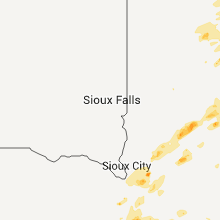
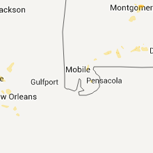
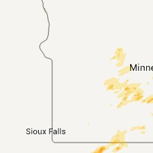
Hail Map for Thursday, June 14, 2012

Number of Impacted Households on 6/14/2012
0
Impacted by 1" or Larger Hail
0
Impacted by 1.75" or Larger Hail
0
Impacted by 2.5" or Larger Hail
Square Miles of Populated Area Impacted on 6/14/2012
0
Impacted by 1" or Larger Hail
0
Impacted by 1.75" or Larger Hail
0
Impacted by 2.5" or Larger Hail


Cities Most Affected by Hail Storms of 6/14/2012
| Hail Size | Demographics of Zip Codes Affected | ||||||
|---|---|---|---|---|---|---|---|
| City | Count | Average | Largest | Pop Density | House Value | Income | Age |
| Hugo, CO | 2 | 1.75 | 1.75 | 0 | $71k | $31.3k | 46.8 |
| Marathon, IA | 2 | 1.75 | 1.75 | 7 | $20k | $28.8k | 47.8 |
| Hendley, NE | 2 | 1.75 | 1.75 | 1 | $45k | $31.4k | 53.1 |
| Glenvil, NE | 1 | 2.50 | 2.50 | 8 | $52k | $37.1k | 41.4 |
| Guymon, OK | 1 | 1.75 | 1.75 | 21 | $71k | $37.3k | 31.3 |
| Harvard, NE | 1 | 1.75 | 1.75 | 6 | $38k | $29.6k | 38.8 |
| Blue Hill, NE | 1 | 1.75 | 1.75 | 6 | $59k | $32.8k | 43.2 |
| Lenora, KS | 1 | 1.75 | 1.75 | 1 | $30k | $31.7k | 50.0 |
| Eclectic, AL | 1 | 1.75 | 1.75 | 68 | $96k | $36.9k | 43.8 |
| Sevierville, TN | 1 | 1.75 | 1.75 | 269 | $118k | $31.6k | 41.0 |
| Ludell, KS | 1 | 1.75 | 1.75 | 2 | $15k | $38.1k | 52.2 |
| Channing, TX | 1 | 1.75 | 1.75 | 0 | $47k | $39.7k | 38.5 |
| Herndon, KS | 1 | 1.75 | 1.75 | 1 | $22k | $25.2k | 53.3 |
| Goodwell, OK | 1 | 1.75 | 1.75 | 1 | $73k | $34.1k | 22.8 |
| Terril, IA | 1 | 1.75 | 1.75 | 7 | $43k | $36.3k | 41.0 |
| Lubbock, TX | 1 | 1.75 | 1.75 | 1001 | $112k | $54.1k | 37.2 |
Hail and Wind Damage Spotted on 6/14/2012
Filter by Report Type:Hail ReportsWind Reports
States Impacted
Wisconsin, Minnesota, Florida, Alabama, Georgia, Louisiana, Tennessee, Texas, Kansas, Nebraska, Iowa, Colorado, OklahomaWisconsin
| Local Time | Report Details |
|---|---|
| 8:00 AM CDT | Quarter sized hail reported near Rice Lake, WI, 82.6 miles ENE of Minneapolis, MN |
Minnesota
| Local Time | Report Details |
|---|---|
| 12:20 PM CDT | Quarter sized hail reported near St Paul, MN, 12 miles E of Minneapolis, MN |
| 12:22 PM CDT | Quarter sized hail reported near Minneapolis, MN, 1.3 miles S of Minneapolis, MN, reported in uptown |
| 12:29 PM CDT | Quarter sized hail reported near St Paul, MN, 4.2 miles E of Minneapolis, MN |
| 12:29 PM CDT | Quarter sized hail reported near Minneapolis, MN, 1.3 miles S of Minneapolis, MN |
| 12:29 PM CDT | Quarter sized hail reported near St Paul, MN, 3.2 miles E of Minneapolis, MN, reported 2 miles south of calhoun beach |
| 12:30 PM CDT | Quarter sized hail reported near St Paul, MN, 15.9 miles ENE of Minneapolis, MN, reported at intersection of 694 and mn hwy 120. |
| 12:30 PM CDT | Quarter sized hail reported near Minneapolis, MN, 2.8 miles ESE of Minneapolis, MN |
| 12:31 PM CDT | Quarter sized hail reported near St Paul, MN, 6.3 miles ENE of Minneapolis, MN, rice and highway 36 |
| 12:32 PM CDT | Quarter sized hail reported near Minneapolis, MN, 1.3 miles S of Minneapolis, MN |
| 12:33 PM CDT | Quarter sized hail reported near St Paul, MN, 8.3 miles ESE of Minneapolis, MN, 35e and maryland |
| 12:35 PM CDT | Quarter sized hail reported near St Paul, MN, 16.2 miles ENE of Minneapolis, MN, highway 694 and 36 |
| 12:37 PM CDT | Quarter sized hail reported near Henderson, MN, 44.9 miles SW of Minneapolis, MN |
| 12:42 PM CDT | Quarter sized hail reported near St Paul, MN, 12 miles E of Minneapolis, MN |
| 12:47 PM CDT | Quarter sized hail reported near St Paul, MN, 8.3 miles ESE of Minneapolis, MN, beach street |
| 2:25 PM CDT | Quarter sized hail reported near Holyoke, MN, 25.9 miles SSW of Duluth, MN |
| 2:29 PM CDT | Power lines down near intersection of midway rd and us highway in st. louis county MN, 8.6 miles W of Duluth, MN |
| 2:29 PM CDT | Power lines down near intersection of midway rd and us highway 2. lines down on highway in st. louis county MN, 8.6 miles W of Duluth, MN |
| 3:15 PM CDT | 40 foot maple snappe in st. louis county MN, 16.3 miles WNW of Duluth, MN |
| 4:03 PM CDT | 10 to 12 inch trees down at 9th and water street in rice county MN, 36.8 miles S of Minneapolis, MN |
| 4:47 PM CDT | Half Dollar sized hail reported near Goodhue, MN, 55.5 miles SE of Minneapolis, MN |
| 4:49 PM CDT | Half Dollar sized hail reported near Goodhue, MN, 57.8 miles SE of Minneapolis, MN |
| 4:58 PM CDT | Quarter sized hail reported near Goodhue, MN, 55.3 miles SE of Minneapolis, MN, mostly nickels with a few quarters...time estimated from radar |
| 6:18 PM CDT | Delayed report machine shop roof damage..several large trees down in martin county MN, 68.7 miles WNW of Mason City, IA |
| 7:00 PM CDT | Multiple reports of wind damage...including trees snapped off...barns and livestock damaged and injured and power lines down from kenyon to wanamingo and zumbrot in goodhue county MN, 51.7 miles SSE of Minneapolis, MN |
| 7:10 PM CDT | Half Dollar sized hail reported near Kenyon, MN, 54.8 miles SSE of Minneapolis, MN |
| 7:12 PM CDT | Numerous large trees downed in along county highway 1... along with a hay wagon blown into the roa in goodhue county MN, 54.2 miles SSE of Minneapolis, MN |
| 7:20 PM CDT | Trained spotters reported lots of trees down and a rotating wall cloud near the city of wasioja in dodge county MN, 66 miles SSE of Minneapolis, MN |
| 7:20 PM CDT | Half of a tree blown down one foot in diameter in dodge county MN, 61.1 miles N of Mason City, IA |
| 7:22 PM CDT | Semi blown over between dodge center and kasson on highway 14 in dodge county MN, 64.1 miles NNE of Mason City, IA |
| 7:30 PM CDT | Emergency management reported trees down in the city of genoa in olmsted county MN, 67.3 miles SSE of Minneapolis, MN |
| 7:41 PM CDT | At kttc studios northwest side of rochester in olmsted county MN, 65.2 miles WNW of La Crosse, WI |
| 7:47 PM CDT | Emergency management reports power outages in the city of rochester in olmsted county MN, 62.8 miles WNW of La Crosse, WI |
| 8:00 PM CDT | Large branches down in town in wabasha county MN, 54.4 miles WNW of La Crosse, WI |
| 8:05 PM CDT | Branches down in town and between elgin and plainview in wabasha county MN, 52 miles WNW of La Crosse, WI |
| 8:15 PM CDT | Law enforcement reported large tree down blocking the road...time estimated from radar in martin county MN, 71.9 miles WNW of Mason City, IA |
| 8:30 PM CDT | Few trees blown down in wabasha county MN, 47.3 miles NW of La Crosse, WI |
Florida
| Local Time | Report Details |
|---|---|
| 1:20 PM EDT | 4 trees felled by downburst in havan in gadsden county FL, 14.9 miles NNW of Tallahassee, FL |
| 2:38 PM EDT | Storm chaser with davis/vantage pro in seminole county FL, 10.5 miles N of Orlando, FL |
| 2:40 PM EDT | A large tree fell on a house on cheetah trail in apopka. time estimated from rada in orange county FL, 12.2 miles NNW of Orlando, FL |
| 2:40 PM EDT | A large tree was knocked down on stoney ridge drive in longwood. time estimated from rada in seminole county FL, 11.8 miles N of Orlando, FL |
| 2:40 PM EDT | A large tree fell on a house on loch lomond avenue in longwood. time estimated from rada in seminole county FL, 11.9 miles N of Orlando, FL |
| 2:43 PM EDT | Corrected from previous report - outdoor furniture and debris blown around with estimated winds 50-60 mp in seminole county FL, 9.8 miles N of Orlando, FL |
| 2:43 PM EDT | Outdoor furniture and debris beiung blown around estimated winds 50-60 mp in seminole county FL, 9.8 miles N of Orlando, FL |
| 2:45 PM EDT | A large tree was reported downed in altamonte springs on baybreeze lane. time estimated from rada in seminole county FL, 9.9 miles N of Orlando, FL |
| 2:47 PM EDT | Two trees were knocked down in longwood off of orlando avenue producing property damage. time estimated from rada in seminole county FL, 10.5 miles N of Orlando, FL |
| 2:50 PM EDT | A tree fell on a house on east maine avenue in longwood. time estimated from rada in seminole county FL, 11.4 miles NNE of Orlando, FL |
| 3:00 PM EDT | 1/4 mile s of city hall. balcony on apartment complex damaged by trees. other trees dow in seminole county FL, 8.5 miles N of Orlando, FL |
| 3:10 PM EDT | 2 trees were reported down on a house and car on east washington street in orlando. time estimated from rada in orange county FL, 1.1 miles E of Orlando, FL |
| 3:14 PM EDT | Douglaston townhome and villas. tree down on roof with damage from storm that just passed through are in seminole county FL, 9.8 miles N of Orlando, FL |
| 3:45 PM EDT | The public reported small tree limbs down in the fort white area. the limbs were less than 2 inches in diamete in columbia county FL, 67 miles WSW of Jacksonville, FL |
| 5:15 PM EDT | Several trees and power lines down at us 92 and wiggins r in hillsborough county FL, 44.8 miles NE of Bradenton, FL |
| 5:15 PM EDT | Quarter sized hail reported near Plant City, FL, 44.8 miles NE of Bradenton, FL, public reported quarter size hail at us 92 and wiggins rd. |
| 4:25 PM CDT | Two trees blown down just in washington county from the washington-jackson county line in the gilberts mill are in washington county FL, 55.1 miles ENE of Miramar Beach, FL |
| 4:30 PM CDT | Large tree limbs blown down. largest was about a foot in diameter and 20 feet lon in washington county FL, 56.3 miles ENE of Miramar Beach, FL |
| 4:45 PM CDT | Half of a pine tree snapped of in washington county FL, 50.3 miles ENE of Miramar Beach, FL |
| 5:05 PM CDT | Trees blown into power line in washington county FL, 42.6 miles NE of Miramar Beach, FL |
| 5:25 PM CDT | Trees down on power lines along highway 2 near darlington. delayed report. time approximat in walton county FL, 42.8 miles NNE of Miramar Beach, FL |
| 5:50 PM CDT | Two trees down and three small tree limbs down near red hill road in walton county. time approximate in walton county FL, 25.1 miles NE of Miramar Beach, FL |
Alabama
| Local Time | Report Details |
|---|---|
| 12:55 PM CDT | One tree down at the intersection of posey rd and nora drive. also one tree down along croft ferry rd northeast of hokes bluff. winds estimated around 40 mph from radar in etowah county AL, 64.6 miles ENE of Birmingham, AL |
| 1:05 PM CDT | One tree down across fords valley road near hokes bluff. time estimated from rada in etowah county AL, 64.6 miles ENE of Birmingham, AL |
| 4:00 PM EDT | Trees down on river road in columbia. reported by dothan eagl in houston county AL, 75.6 miles NW of Tallahassee, FL |
| 3:08 PM CDT | Quarter sized hail reported near Anniston, AL, 57 miles ENE of Birmingham, AL |
| 3:33 PM CDT | One tree reported down on water tank lan in talladega county AL, 42 miles E of Birmingham, AL |
| 3:47 PM CDT | Trees and power lines blown down in northern houston count in houston county AL, 81.6 miles NW of Tallahassee, FL |
| 3:50 PM CDT | Trees down on wallace buie road. reported by dothan eagl in houston county AL, 80.8 miles NW of Tallahassee, FL |
| 3:50 PM CDT | Trees downed on jimbo road. reported by dothan eagl in houston county AL, 81.9 miles NW of Tallahassee, FL |
| 3:50 PM CDT | Quarter sized hail reported near Cusseta, AL, 14.9 miles NE of Auburn, AL, dime to quarter size hail fell for several minutes. |
| 4:05 PM CDT | Dispatch in houston county reports multiple calls related to tree damage...downed power lines...and power outages in the northern part of houston county and in the doth in houston county AL, 82 miles NE of Miramar Beach, FL |
| 4:05 PM CDT | One tree blown down in the pinckard are in dale county AL, 80.4 miles NE of Miramar Beach, FL |
| 4:15 PM CDT | A couple reports of trees limbs down...blown into power lines in ozar in dale county AL, 81.5 miles S of Auburn, AL |
| 4:42 PM CDT | Spotter measured wind gust on a hand held anemometer one mile east of the bama jam facilities on hwy 5 in coffee county AL, 77.9 miles NNE of Miramar Beach, FL |
| 4:45 PM CDT | *** 1 inj *** thunderstorm wind gusts tore the roof off a temporary structure at bama jam...injuring one perso in coffee county AL, 77.4 miles NNE of Miramar Beach, FL |
| 4:55 PM CDT | Trees and power lines down in and around enterpris in coffee county AL, 71.2 miles NNE of Miramar Beach, FL |
| 6:00 PM CDT | A tree was blown onto a hous in elmore county AL, 35.5 miles W of Auburn, AL |
| 6:00 PM CDT | A tree down on a house with minor damage to the roof. powerlines also reported down in the blue ridge community. corrected for locatio in elmore county AL, 41.7 miles WSW of Auburn, AL |
| 6:00 PM CDT | Golf Ball sized hail reported near Eclectic, AL, 35.5 miles W of Auburn, AL, near haynes road and highway 14. |
| 6:02 PM CDT | Multiple trees down in the claud and fleahop communitie in elmore county AL, 31.4 miles W of Auburn, AL |
| 6:42 PM CDT | The evergreen middleton field asos recorded a 59 mph wind gust at 642 pm cd in conecuh county AL, 42.1 miles SSE of Camden, AL |
| 8:25 PM CDT | 40-45 mph sustained for 10 minutes in escambia county AL, 41.8 miles NE of Mobile, AL |
| 2:36 AM CDT | 40-45 mph sustained for 10 minutes in escambia county AL, 41.8 miles NE of Mobile, AL |
Georgia
| Local Time | Report Details |
|---|---|
| 2:00 PM EDT | 2 trees fellled by downburs in dougherty county GA, 69.1 miles W of Douglas, GA |
| 3:08 PM EDT | 2 trees felled by downburs in colquitt county GA, 57.8 miles NNE of Tallahassee, FL |
| 3:08 PM EDT | Quarter sized hail reported near Moultrie, GA, 57.8 miles NNE of Tallahassee, FL, large hail reported. |
| 4:54 PM EDT | Quarter sized hail reported near Buena Vista, GA, 65.5 miles ESE of Auburn, AL, the draneville local store reported quarter sized hail along with water running through the aisles. |
| 5:05 PM EDT | A few trees and power lines down near highway 39 in northern clay count in clay county GA, 62.3 miles SSE of Auburn, AL |
| 5:15 PM EDT | Quarter sized hail reported near Preston, GA, 63.1 miles ESE of Auburn, AL, emergency manager relayed a report of quarter sized hail south of highway 30 between buena vista and preston. |
| 5:22 PM EDT | Stewart county sheriffs office relayed a report of a downed tree in lumpkin. radar estimated time of 1722 ed in stewart county GA, 55.8 miles SE of Auburn, AL |
| 5:22 PM EDT | A county official reported a tree down on troatman roa in stewart county GA, 57.6 miles SE of Auburn, AL |
| 5:22 PM EDT | County official reported a tree down on holder roa in stewart county GA, 59.3 miles SE of Auburn, AL |
| 5:22 PM EDT | Emergency manager reported 3 trees down approximately six miles east of lumpki in stewart county GA, 60.2 miles SE of Auburn, AL |
| 6:30 PM EDT | Toombs county emergency management relayed reports of 2-3 trees downed onto 2 houses and a car. radar estimated time of 1830 ed in toombs county GA, 38.7 miles NE of Douglas, GA |
| 6:30 PM EDT | Toombs county emergency management relayed reports of 2-3 trees downed onto 2 houses. radar estimated time of 1830 ed in toombs county GA, 38.7 miles NE of Douglas, GA |
| 7:10 PM EDT | The 911 center received reports of trees and powerlines down including a report of a tree landing on a mobile home. no reports of injuries at this tim in jeff davis county GA, 29.1 miles NNE of Douglas, GA |
| 7:40 PM EDT | Emergency manager reported ten to fifteen trees down along whitfield roa in houston county GA, 78.7 miles NW of Douglas, GA |
Louisiana
| Local Time | Report Details |
|---|---|
| 2:21 PM CDT | Knbg pkwnd 20054/192 in plaquemines county LA, 8.5 miles SSE of New Orleans, LA |
| 2:26 PM CDT | Knbg pkwnd 18054/192 in plaquemines county LA, 8.5 miles SSE of New Orleans, LA |
| 2:27 PM CDT | Newspaper reports downed trees and power lines in marrero and harvey due to thunderstorm winds in jefferson county LA, 4.8 miles SSW of New Orleans, LA |
| 4:40 PM CDT | Tree down across interstate 20 at calhou in ouachita county LA, 31.1 miles WSW of Bastrop, LA |
Tennessee
| Local Time | Report Details |
|---|---|
| 3:55 PM EDT | Utility company reported a couple trees down on power lines on sweetwater vonore roa in monroe county TN, 30.2 miles SW of Knoxville, TN |
| 3:55 PM EDT | Utility company reported a tree down on power lines on northfork roa in monroe county TN, 39.4 miles SW of Knoxville, TN |
| 6:06 PM EDT | One tree dow in blount county TN, 21.2 miles SSE of Knoxville, TN |
| 6:10 PM EDT | Utility company reported power lines down due to a fallen tree off of carrs creek roa in blount county TN, 21.6 miles SSE of Knoxville, TN |
| 6:46 PM EDT | Golf Ball sized hail reported near Sevierville, TN, 22.8 miles SE of Knoxville, TN |
| 7:05 PM EDT | Utility company reported several trees and power lines down in the oakdale are in morgan county TN, 35.9 miles W of Knoxville, TN |
| 7:10 PM EDT | A couple of trees down on grandview mountai in rhea county TN, 51.8 miles WSW of Knoxville, TN |
| 7:35 PM CDT | Utility company reported several locations with power lines knocked down by large tree limbs and trees including highway 127 and upper east valley roa in bledsoe county TN, 41 miles N of Chattanooga, TN |
| 8:36 PM EDT | Two trees dow in morgan county TN, 35.9 miles W of Knoxville, TN |
| 8:40 PM EDT | Numerous trees down. numerous reports of damage. roads blocke in morgan county TN, 35.9 miles W of Knoxville, TN |
Texas
| Local Time | Report Details |
|---|---|
| 3:45 PM CDT | Report of wind damage at holly park off toledo bend lak in sabine county TX, 60.1 miles E of Lufkin, TX |
| 3:45 PM CDT | Wind damage at holly park marina on toledo bend lake. powerlines down nearby and leaf debris in sabine county TX, 55.6 miles ENE of Lufkin, TX |
| 4:00 PM CDT | Trees down along highway 21 near genev in sabine county TX, 52.3 miles ENE of Lufkin, TX |
| 4:15 PM CDT | Tree down along highway 21 southeast of san augustin in san augustine county TX, 41 miles ENE of Lufkin, TX |
| 5:04 PM CDT | Quarter sized hail reported near Hereford, TX, 40.9 miles SW of Amarillo, TX |
| 5:10 PM CDT | Half Dollar sized hail reported near Hereford, TX, 40 miles SW of Amarillo, TX, relayed by nssl |
| 5:15 PM CDT | Half Dollar sized hail reported near Hereford, TX, 40.9 miles SW of Amarillo, TX |
| 5:15 PM CDT | Quarter sized hail reported near Hereford, TX, 39.6 miles SW of Amarillo, TX, relayed by nssl |
| 6:06 PM CDT | Quarter sized hail reported near Wildorado, TX, 20.1 miles W of Amarillo, TX, relayed by nssl |
| 6:11 PM CDT | Quarter sized hail reported near Wildorado, TX, 20.2 miles W of Amarillo, TX |
| 6:13 PM CDT | Quarter sized hail reported near Fort Stockton, TX, 57.5 miles NE of Alpine, TX, 2 mi west of fort stockton on alpine highway |
| 6:40 PM CDT | Golf Ball sized hail reported near Channing, TX, 51.8 miles NNW of Amarillo, TX |
| 6:45 PM CDT | Storm damage reported in hale county TX, 33.6 miles N of Lubbock, TX |
| 6:54 PM CDT | Quarter sized hail reported near Dumas, TX, 42 miles NNW of Amarillo, TX |
| 6:57 PM CDT | Half Dollar sized hail reported near Dumas, TX, 41.7 miles NNW of Amarillo, TX |
| 7:00 PM CDT | Storm damage reported in hale county TX, 43 miles N of Lubbock, TX |
| 7:05 PM CDT | West texas mesonet in hale county TX, 41.3 miles N of Lubbock, TX |
| 7:15 PM CDT | West texas mesonet report in hale county TX, 19.8 miles NNE of Lubbock, TX |
| 7:22 PM CDT | Storm damage reported in potter county TX, 6.5 miles E of Amarillo, TX |
| 7:55 PM CDT | West texas mesonet report in floyd county TX, 42.2 miles NE of Lubbock, TX |
| 7:55 PM CDT | Storm damage reported in donley county TX, 53.1 miles NW of Childress, TX |
| 8:03 PM CDT | Tree uproote in ector county TX, 0.3 miles E of Odessa, TX |
| 8:05 PM CDT | West texas mesonet report in hall county TX, 41.2 miles W of Childress, TX |
| 8:06 PM CDT | Half Dollar sized hail reported near Clarendon, TX, 53.6 miles ESE of Amarillo, TX |
| 8:13 PM CDT | Half Dollar sized hail reported near Andrews, TX, 34 miles NNW of Odessa, TX |
| 8:40 PM CDT | West texas mesonet report in lubbock county TX, 10 miles W of Lubbock, TX |
| 8:45 PM CDT | West texas mesonet in motley county TX, 50.2 miles SW of Childress, TX |
| 9:00 PM CDT | Storm damage reported in donley county TX, 52.6 miles NNW of Childress, TX |
| 9:15 PM CDT | Golf Ball sized hail reported near Lubbock, TX, 7.1 miles SSW of Lubbock, TX, golf ball hail reported |
| 9:15 PM CDT | Quarter sized hail reported near Lubbock, TX, 7.2 miles S of Lubbock, TX |
| 9:20 PM CDT | Quarter sized hail reported near Lubbock, TX, 9.6 miles SW of Lubbock, TX |
| 9:30 PM CDT | West texas mesonet report in cottle county TX, 37.9 miles SSW of Childress, TX |
| 9:43 PM CDT | Quarter sized hail reported near Booker, TX, 63.6 miles W of Woodward, OK |
| 9:55 PM CDT | Quarter sized hail reported near Booker, TX, 52.4 miles W of Woodward, OK |
| 10:15 PM CDT | Storm damage reported in donley county TX, 53.1 miles NW of Childress, TX |
| 10:50 PM CDT | West texas mesonet report in garza county TX, 39 miles SE of Lubbock, TX |
| 1:50 AM CDT | West texas mesonet report in childress county TX, 1.8 miles NW of Childress, TX |
| 1:50 AM CDT | Storm damage reported in childress county TX, 3.4 miles WNW of Childress, TX |
| 2:10 AM CDT | Gusts from dissipating showers in excess of 60 mph from 205 am to 220 am peaking at 210 am in childress county TX, 1.8 miles NW of Childress, TX |
Kansas
| Local Time | Report Details |
|---|---|
| 4:30 PM CDT | Quarter sized hail reported near Herndon, KS, 40.4 miles NNE of Colby, KS, estimated location of report. |
| 4:30 PM CDT | Golf Ball sized hail reported near Herndon, KS, 38.4 miles N of Colby, KS, hail still falling. ground white with pea to golf ball size hail. |
| 4:55 PM CDT | Golf Ball sized hail reported near Ludell, KS, 35.7 miles N of Colby, KS, dime size hail still falling. |
| 5:50 PM CDT | Quarter sized hail reported near Norton, KS, 67.5 miles ENE of Colby, KS, estimated gusts up to 70 mph. |
| 5:50 PM CDT | Quarter sized hail reported near Norton, KS, 65 miles ENE of Colby, KS |
| 5:50 PM CDT | Rolled over camper at airport...estimated 60 mph winds. numerous trees down in norton and numerous power outage in norton county KS, 68.8 miles ENE of Colby, KS |
| 5:50 PM CDT | Rolled over camper at airport...estimated 60 mph winds. numerous trees down in norton in norton county KS, 68.8 miles ENE of Colby, KS |
| 5:58 PM CDT | Large tree down. tree limbs 3 to 4 inch in diameter broken off. nickel sized hai in norton county KS, 68.8 miles ENE of Colby, KS |
| 6:00 PM CDT | Quarter sized hail reported near Norton, KS, 68.8 miles ENE of Colby, KS |
| 6:03 PM CDT | Storm damage reported in stanton county KS, 54.1 miles WSW of Garden City, KS |
| 6:10 PM CDT | Parts of roofing ripped off building. two branches over 4 inches in diameter branches blown down onto roa in norton county KS, 68.8 miles ENE of Colby, KS |
| 6:15 PM CDT | Storm damage reported in grant county KS, 39.6 miles WSW of Garden City, KS |
| 6:26 PM CDT | Storm damage reported in norton county KS, 69.9 miles NNW of Hays, KS |
| 6:30 PM CDT | Golf Ball sized hail reported near Lenora, KS, 55.6 miles NNW of Hays, KS |
| 6:35 PM CDT | Quarter sized hail reported near Arnold, KS, 44 miles WSW of Hays, KS |
| 6:45 PM CDT | The report was from near ness cit in ness county KS, 42.7 miles SW of Hays, KS |
| 6:48 PM CDT | Storm damage reported in phillips county KS, 60 miles N of Hays, KS |
| 6:50 PM CDT | Quarter sized hail reported near Garden City, KS, 1 miles NE of Garden City, KS |
| 6:50 PM CDT | Six to seven powerlines were blown down. numerous tree limbs reported blown down around tow in finney county KS, 1.8 miles E of Garden City, KS |
| 6:54 PM CDT | Quarter sized hail reported near Hill City, KS, 44.3 miles NW of Hays, KS, estimated 40 to 50 mph winds |
| 6:55 PM CDT | Storm damage reported in graham county KS, 44.3 miles NW of Hays, KS |
| 7:00 PM CDT | Storm damage reported in finney county KS, 2.2 miles NNE of Garden City, KS |
| 7:00 PM CDT | An empty truck trailor was blown over just west of garden city and 1 foot diameter tree limbs were blown down on 5th stree in finney county KS, 1 miles NE of Garden City, KS |
| 7:00 PM CDT | Two semi trailer trucks were rolle in finney county KS, 0.8 miles NNW of Garden City, KS |
| 7:05 PM CDT | Storm damage reported in graham county KS, 44.3 miles NW of Hays, KS |
| 7:10 PM CDT | Quarter sized hail reported near Dighton, KS, 36.9 miles NNE of Garden City, KS |
| 7:10 PM CDT | Quarter sized hail reported near Collyer, KS, 38.2 miles WNW of Hays, KS |
| 7:15 PM CDT | Dime-sized hail. wind gusts estimated 50 to 60 mp in graham county KS, 38.8 miles NNW of Hays, KS |
| 7:18 PM CDT | Quarter sized hail reported near Scott City, KS, 49.1 miles NNW of Garden City, KS |
| 7:20 PM CDT | Quarter sized hail reported near Scott City, KS, 49.1 miles NNW of Garden City, KS |
| 7:20 PM CDT | Measured gust at rooks co airport in rooks county KS, 35.3 miles N of Hays, KS |
| 7:20 PM CDT | Measured gust at rooks county airport in rooks county KS, 35.3 miles N of Hays, KS |
| 7:40 PM CDT | Storm damage reported in smith county KS, 67.9 miles NNE of Hays, KS |
| 7:50 PM CDT | Storm damage reported in trego county KS, 29.8 miles WNW of Hays, KS |
| 7:50 PM CDT | Quarter sized hail reported near Hoxie, KS, 37.4 miles E of Colby, KS |
| 7:59 PM CDT | Storm damage reported in ellis county KS, 15.6 miles NW of Hays, KS |
| 8:00 PM CDT | Storm damage reported in gove county KS, 42.4 miles SE of Colby, KS |
| 8:00 PM CDT | Storm damage reported in ness county KS, 35.5 miles SW of Hays, KS |
| 8:04 PM CDT | Storm damage reported in washington county KS, 70 miles NW of Manhattan, KS |
| 8:20 PM CDT | Visibility was reduced to near zero in blowing dus in hodgeman county KS, 52.6 miles E of Garden City, KS |
| 8:22 PM CDT | Quarter sized hail reported near Hays, KS, 7.3 miles NE of Hays, KS |
| 8:24 PM CDT | Heavy rainfall and limited visibility in republic county KS, 75.6 miles SSE of Grand Island, NE |
| 8:25 PM CDT | Storm damage reported in washington county KS, 62.6 miles NNW of Manhattan, KS |
| 8:33 PM CDT | Ping Pong Ball sized hail reported near Oakley, KS, 21.2 miles SSE of Colby, KS |
| 8:34 PM CDT | Storm damage reported in mitchell county KS, 76.7 miles ENE of Hays, KS |
| 8:35 PM CDT | Storm damage reported in rush county KS, 24 miles SSE of Hays, KS |
| 8:59 PM CDT | Storm damage reported in cloud county KS, 70.7 miles WNW of Manhattan, KS |
| 9:31 PM CDT | Small branches down in ottawa county KS, 61.8 miles W of Manhattan, KS |
| 9:38 PM CDT | Storm damage reported in ottawa county KS, 53.1 miles W of Manhattan, KS |
| 9:49 PM CDT | Storm damage reported in kiowa county KS, 80.6 miles N of Woodward, OK |
| 10:10 PM CDT | Time estimated in dickinson county KS, 39.2 miles WSW of Manhattan, KS |
| 10:16 PM CDT | Storm damage reported in dickinson county KS, 41.2 miles WSW of Manhattan, KS |
| 11:49 PM CDT | Storm damage reported in chase county KS, 56.6 miles NE of Wichita, KS |
| 12:29 AM CDT | Large tree limbs downe in butler county KS, 19.5 miles E of Wichita, KS |
| 12:38 AM CDT | Storm damage reported in sumner county KS, 25.5 miles S of Wichita, KS |
| 12:46 AM CDT | Storm damage reported in sumner county KS, 25.5 miles S of Wichita, KS |
| 1:04 AM CDT | Large tree limbs downed near highway 81 and highway 166 intersectio in sumner county KS, 43.4 miles S of Wichita, KS |
| 2:20 AM CDT | Storm damage reported in chautauqua county KS, 55.3 miles SW of Chanute, KS |
| 2:45 AM CDT | Tree downe in montgomery county KS, 53.3 miles SSW of Chanute, KS |
Nebraska
| Local Time | Report Details |
|---|---|
| 4:48 PM CDT | Quarter sized hail reported near Wilsonville, NE, 70 miles NE of Colby, KS |
| 4:51 PM CDT | Golf Ball sized hail reported near Harvard, NE, 24.5 miles SSE of Grand Island, NE, golf ball sized hail with heavy rain in town. |
| 4:57 PM CDT | Ping Pong Ball sized hail reported near Wilsonville, NE, 70 miles NE of Colby, KS, a few ping pong ball size stones |
| 5:04 PM CDT | Quarter sized hail reported near Danbury, NE, 56.1 miles NE of Colby, KS, estimated 40-50 mph winds. |
| 5:10 PM CDT | Quarter sized hail reported near Wilsonville, NE, 67.2 miles NE of Colby, KS, lasted for about 15 minutes 510pm-525pm. |
| 5:14 PM CDT | Quarter sized hail reported near Wilsonville, NE, 67.2 miles NE of Colby, KS |
| 5:15 PM CDT | Quarter sized hail reported near Brainard, NE, 53.7 miles W of Omaha, NE, 1.80 of rain fell with the hail. |
| 5:25 PM CDT | Quarter sized hail reported near Orleans, NE, 80.1 miles SW of Grand Island, NE |
| 5:35 PM CDT | Half Dollar sized hail reported near Danbury, NE, 61.6 miles NNE of Colby, KS |
| 5:45 PM CDT | Quarter sized hail reported near Herman, NE, 31.8 miles NNW of Omaha, NE, hail up to quarter size |
| 5:53 PM CDT | Quarter sized hail reported near Hastings, NE, 28 miles S of Grand Island, NE, hail up to quarter size for the last 10 minutes |
| 5:56 PM CDT | Quarter sized hail reported near Seward, NE, 64.9 miles E of Grand Island, NE, hail up to quarter size in seward reported by a lancaster county spotter who was in seward. |
| 5:57 PM CDT | Golf Ball sized hail reported near Hendley, NE, 78.7 miles NE of Colby, KS, 70mph wind was also reported along with the hail. |
| 6:00 PM CDT | Outflow winds estimated at 60 to 70 mph in saunders county NE, 39.5 miles WSW of Omaha, NE |
| 6:03 PM CDT | Golf Ball sized hail reported near Hendley, NE, 75.1 miles NE of Colby, KS, 70 mph wind gusts were also reported with this storm |
| 6:07 PM CDT | Quarter sized hail reported near Glenvil, NE, 29.7 miles S of Grand Island, NE, also 45 mph gusts |
| 6:08 PM CDT | At the lincoln airpor in lancaster county NE, 49.6 miles SW of Omaha, NE |
| 6:10 PM CDT | Ping Pong Ball sized hail reported near Glenvil, NE, 28.6 miles S of Grand Island, NE, ping pong ball size hail and also gusts up to 60 mph along showboat road |
| 6:14 PM CDT | Tennis Ball sized hail reported near Glenvil, NE, 29.7 miles S of Grand Island, NE, tennis ball size |
| 6:19 PM CDT | Ping Pong Ball sized hail reported near Mccook, NE, 53.6 miles S of North Platte, NE |
| 6:27 PM CDT | Storm damage reported in harlan county NE, 83.5 miles SW of Grand Island, NE |
| 6:30 PM CDT | Storm damage reported in clay county NE, 42.9 miles SSE of Grand Island, NE |
| 6:32 PM CDT | Storm damage reported in nuckolls county NE, 44 miles S of Grand Island, NE |
| 6:32 PM CDT | Quarter sized hail reported near Nelson, NE, 41 miles SSE of Grand Island, NE |
| 6:48 PM CDT | There are trees down along with power outages in harlan county NE, 80.1 miles SW of Grand Island, NE |
| 6:48 PM CDT | Golf Ball sized hail reported near Blue Hill, NE, 50 miles S of Grand Island, NE, wind gusts estimated to be 60 mph with golf ball sized hail ongoing along with very heavy rainfall. |
| 6:55 PM CDT | There are several trees down due to thunderstorm wind gusts in harlan county NE, 78.3 miles SW of Grand Island, NE |
| 6:57 PM CDT | Storm damage reported in sarpy county NE, 10.5 miles S of Omaha, NE |
| 7:00 PM CDT | Storm damage reported in sarpy county NE, 10.5 miles S of Omaha, NE |
| 7:00 PM CDT | 4 inch diameter tree limbs down and power out at 84th and gile in sarpy county NE, 7.6 miles SW of Omaha, NE |
| 7:05 PM CDT | Ping Pong Ball sized hail reported near Hildreth, NE, 55 miles SW of Grand Island, NE |
| 7:16 PM CDT | Storm damage reported in sarpy county NE, 10.4 miles S of Omaha, NE |
| 7:22 PM CDT | Half Dollar sized hail reported near Bruning, NE, 57.5 miles SE of Grand Island, NE, hail ongoing. |
| 7:40 PM CDT | Storm damage reported in thayer county NE, 73 miles SSE of Grand Island, NE |
Iowa
| Local Time | Report Details |
|---|---|
| 6:15 PM CDT | Quarter sized hail reported near Storm Lake, IA, 9.2 miles NNE of Storm Lake, IA |
| 6:22 PM CDT | Golf Ball sized hail reported near Marathon, IA, 14.5 miles NNE of Storm Lake, IA |
| 6:25 PM CDT | Golf Ball sized hail reported near Marathon, IA, 17.3 miles NNE of Storm Lake, IA |
| 6:28 PM CDT | Quarter sized hail reported near Paullina, IA, 31.8 miles NW of Storm Lake, IA |
| 6:30 PM CDT | Half Dollar sized hail reported near Marathon, IA, 20.7 miles NNE of Storm Lake, IA |
| 6:50 PM CDT | Quarter sized hail reported near Moville, IA, 46.4 miles WSW of Storm Lake, IA |
| 7:05 PM CDT | Quarter sized hail reported near Spencer, IA, 37.4 miles N of Storm Lake, IA |
| 7:25 PM CDT | Quarter sized hail reported near Terril, IA, 45.6 miles NNE of Storm Lake, IA |
| 7:25 PM CDT | Trees down in dickinson county IA, 47.2 miles NNE of Storm Lake, IA |
| 7:25 PM CDT | Several 5-6 inch diameter limbs broken of in dickinson county IA, 45.6 miles NNE of Storm Lake, IA |
| 7:29 PM CDT | Quarter sized hail reported near Ringsted, IA, 61.1 miles NE of Storm Lake, IA, mostly pea size hail with a few nickel to quarter size hailstones. |
| 7:30 PM CDT | Golf Ball sized hail reported near Terril, IA, 47.5 miles NNE of Storm Lake, IA |
| 7:33 PM CDT | Damage to house...trees...and powerlines. possible tornad in emmet county IA, 48.9 miles NNE of Storm Lake, IA |
| 7:33 PM CDT | Updated report. some trees uprooted and powerlines down. earlier damage to the house was only a broken windo in emmet county IA, 48.9 miles NNE of Storm Lake, IA |
| 7:37 PM CDT | Ping Pong Ball sized hail reported near Estherville, IA, 53.3 miles NNE of Storm Lake, IA |
| 7:47 PM CDT | Storm damage reported in emmet county IA, 57.4 miles NNE of Storm Lake, IA |
Colorado
| Local Time | Report Details |
|---|---|
| 5:51 PM MDT | Quarter sized hail reported near Lamar, CO, 96.7 miles W of Garden City, KS |
| 9:39 PM MDT | Golf Ball sized hail reported near Hugo, CO, 79 miles SSW of Yuma, CO, broken windshields |
| 9:47 PM MDT | Ping Pong Ball sized hail reported near Hugo, CO, 79 miles SSW of Yuma, CO |
| 9:48 PM MDT | Golf Ball sized hail reported near Hugo, CO, 79 miles SSW of Yuma, CO |
| 10:15 PM MDT | Quarter sized hail reported near Hugo, CO, 72.7 miles SSW of Yuma, CO |
| 10:46 PM MDT | Quarter sized hail reported near Genoa, CO, 62.2 miles SW of Yuma, CO |
Oklahoma
| Local Time | Report Details |
|---|---|
| 7:45 PM CDT | 2 foot diameter tree was broken about 2 to 3 feet above the ground. estimated 70 mph wind gus in beaver county OK, 70.4 miles S of Garden City, KS |
| 7:52 PM CDT | Quarter sized hail reported near Guymon, OK, 92.4 miles SSW of Garden City, KS |
| 7:54 PM CDT | Quarter sized hail reported near Guymon, OK, 94.7 miles SSW of Garden City, KS |
| 7:55 PM CDT | Half Dollar sized hail reported near Guymon, OK, 89.8 miles SSW of Garden City, KS |
| 7:56 PM CDT | Golf Ball sized hail reported near Guymon, OK, 94.7 miles SSW of Garden City, KS |
| 8:15 PM CDT | Golf Ball sized hail reported near Goodwell, OK, 101.6 miles N of Amarillo, TX |
| 8:15 PM CDT | Ping Pong Ball sized hail reported near Guymon, OK, 89.2 miles SSW of Garden City, KS |
| 8:44 PM CDT | Quarter sized hail reported near Turpin, OK, 73.1 miles S of Garden City, KS, from 7 miles south of the kansas and oklahoma state line along hollow north 115 and then 1 mile east along hollow east 0070. |
| 9:08 PM CDT | With dime size hail...heavy rain...leading to near zero visibility in texas county OK, 76 miles S of Garden City, KS |
| 9:10 PM CDT | Storm damage reported in beaver county OK, 67.8 miles WNW of Woodward, OK |
| 9:15 PM CDT | Storm damage reported in beaver county OK, 67.8 miles WNW of Woodward, OK |
| 9:35 PM CDT | Storm damage reported in beaver county OK, 67.8 miles WNW of Woodward, OK |
| 9:46 PM CDT | Quarter sized hail reported near Balko, OK, 61.5 miles W of Woodward, OK |
| 9:59 PM CDT | Quarter sized hail reported near Laverne, OK, 57 miles WNW of Woodward, OK |
| 10:10 PM CDT | Quarter sized hail reported near Laverne, OK, 39.4 miles WNW of Woodward, OK |
| 10:10 PM CDT | Quarter sized hail reported near Hollis, OK, 27.6 miles NE of Childress, TX, nickel to quarter hail. e50mph gust. |
| 10:40 PM CDT | Ok mesonet in woods county OK, 43.7 miles NNE of Woodward, OK |
| 10:45 PM CDT | Storm damage reported in woods county OK, 43.7 miles NNE of Woodward, OK |
| 11:00 PM CDT | Storm damage reported in woodward county OK, 25.3 miles NE of Woodward, OK |
| 12:35 AM CDT | Woodring awos in garfield county OK, 63.6 miles NNW of Oklahoma City, OK |
| 1:07 AM CDT | Storm damage reported in kay county OK, 52.9 miles S of Wichita, KS |
Connect with Interactive Hail Maps