

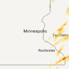
Hail Map for Sunday, April 10, 2011

Number of Impacted Households on 4/10/2011
0
Impacted by 1" or Larger Hail
0
Impacted by 1.75" or Larger Hail
0
Impacted by 2.5" or Larger Hail
Square Miles of Populated Area Impacted on 4/10/2011
0
Impacted by 1" or Larger Hail
0
Impacted by 1.75" or Larger Hail
0
Impacted by 2.5" or Larger Hail


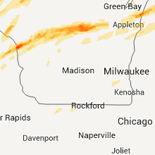


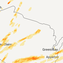


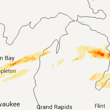


Cities Most Affected by Hail Storms of 4/10/2011
| Hail Size | Demographics of Zip Codes Affected | ||||||
|---|---|---|---|---|---|---|---|
| City | Count | Average | Largest | Pop Density | House Value | Income | Age |
| La Crosse, WI | 5 | 2.00 | 2.50 | 624 | $94k | $34.8k | 30.3 |
| Ashland, WI | 2 | 2.38 | 3.00 | 42 | $66k | $33.2k | 40.1 |
| Kewaunee, WI | 2 | 1.88 | 2.00 | 57 | $85k | $42.6k | 44.1 |
| Menard, TX | 2 | 1.75 | 1.75 | 1 | $30k | $23.1k | 49.4 |
| New Auburn, WI | 2 | 1.75 | 1.75 | 21 | $77k | $34.0k | 42.0 |
| Wild Rose, WI | 2 | 1.75 | 1.75 | 40 | $88k | $34.6k | 52.1 |
| Prosper, TX | 2 | 1.75 | 1.75 | 392 | $144k | $70.0k | 34.4 |
| Hokah, MN | 1 | 3.00 | 3.00 | 18 | $83k | $36.9k | 42.3 |
| Winneconne, WI | 1 | 2.75 | 2.75 | 167 | $111k | $54.7k | 46.2 |
| Fordland, MO | 1 | 2.75 | 2.75 | 44 | $78k | $33.3k | 38.8 |
| Stilwell, OK | 1 | 2.00 | 2.00 | 40 | $46k | $23.3k | 35.2 |
| Elk Mound, WI | 1 | 2.00 | 2.00 | 47 | $99k | $47.9k | 36.4 |
| Crandon, WI | 1 | 2.00 | 2.00 | 30 | $82k | $30.8k | 41.0 |
| Bowie, TX | 1 | 1.75 | 1.75 | 26 | $56k | $31.5k | 43.2 |
| Medford, WI | 1 | 1.75 | 1.75 | 33 | $81k | $41.2k | 41.6 |
| Hamilton, TX | 1 | 1.75 | 1.75 | 12 | $45k | $31.2k | 47.6 |
| Fort Worth, TX | 1 | 1.75 | 1.75 | 2775 | $53k | $31.2k | 33.6 |
| Sparta, WI | 1 | 1.75 | 1.75 | 69 | $78k | $37.4k | 39.6 |
| Menomonie, WI | 1 | 1.75 | 1.75 | 102 | $101k | $37.7k | 27.7 |
| Wautoma, WI | 1 | 1.75 | 1.75 | 53 | $90k | $35.3k | 46.4 |
| Marengo, WI | 1 | 1.75 | 1.75 | 12 | $60k | $32.6k | 31.1 |
| Brownsville, MN | 1 | 1.75 | 1.75 | 13 | $86k | $47.2k | 46.2 |
| Holdenville, OK | 1 | 1.75 | 1.75 | 25 | $33k | $21.7k | 37.8 |
| Humansville, MO | 1 | 1.75 | 1.75 | 26 | $44k | $24.9k | 43.1 |
| Little Elm, TX | 1 | 1.75 | 1.75 | 1450 | $115k | $53.4k | 31.3 |
| Houston, MN | 1 | 1.75 | 1.75 | 15 | $73k | $37.1k | 44.3 |
| Priddy, TX | 1 | 1.75 | 1.75 | 2 | $37k | $36.3k | 37.4 |
| Osseo, WI | 1 | 1.75 | 1.75 | 27 | $78k | $40.1k | 40.6 |
| Marcell, MN | 1 | 1.75 | 1.75 | 7 | $111k | $34.0k | 57.0 |
Hail and Wind Damage Spotted on 4/10/2011
Filter by Report Type:Hail ReportsWind Reports
States Impacted
Michigan, Minnesota, Wisconsin, Iowa, Texas, Oklahoma, Missouri, Illinois, Arkansas, IndianaMichigan
| Local Time | Report Details |
|---|---|
| 12:38 PM UTC | Quarter sized hail reported near Elkton, MI, 60.1 miles NNE of Flint, MI |
| 10:37 PM UTC | Quarter sized hail reported near Empire, MI, 22.1 miles W of Traverse City, MI |
| 10:45 PM UTC | Quarter sized hail reported near Maple City, MI, 14 miles WNW of Traverse City, MI |
| 10:47 PM UTC | Quarter sized hail reported near Maple City, MI, 14 miles WNW of Traverse City, MI |
| 11:57 PM UTC | Quarter sized hail reported near Grayling, MI, 45.1 miles E of Traverse City, MI |
| 12:25 AM UTC | Quarter sized hail reported near Lincoln, MI, 23 miles S of Alpena, MI, hail covered the ground |
| 9:00 AM UTC | Four inch diameter limbs down near the intersection of cooley lake rd and carroll lake rd in oakland county MI, 29.6 miles SSE of Flint, MI |
Minnesota
| Local Time | Report Details |
|---|---|
| 4:35 PM UTC | Golf Ball sized hail reported near Marcell, MN, 56.2 miles E of Bemidji, MN, ongoing. neighbors car window broken due to hail. |
| 5:08 PM UTC | A few trees blown down starting east of togo around itasca-st louis county line near south of hwy 1 and near hwy 22 stretching east into cook area. delayed repor in itasca county MN, 55.7 miles SSE of International Falls, MN |
| 5:27 PM UTC | Lots of trees down near the intersection of hwy 73 and hwy 22 north of side lake. delayed repor in st. louis county MN, 62 miles SSE of International Falls, MN |
| 5:35 PM UTC | Report relayed by law enforcement. damage to boat house and tree damag in st. louis county MN, 56.1 miles SSE of International Falls, MN |
| 5:35 PM UTC | Witnessed garage roof lift into air and fall back onto walls. some damage to garage walls. boat house of unknown construction destroyed. tree damag in st. louis county MN, 56.1 miles SSE of International Falls, MN |
| 5:47 PM UTC | Trees and powerlines down in cook are in st. louis county MN, 61.6 miles SSE of International Falls, MN |
| 9:10 PM UTC | Quarter sized hail reported near Red Wing, MN, 45.6 miles SE of Minneapolis, MN |
| 9:15 PM UTC | Barn down and 1 tree down on road in fillmore county MN, 35.8 miles WSW of La Crosse, WI |
| 9:20 PM UTC | 2 foot diameter tree down blocking the roa in fillmore county MN, 41.2 miles WSW of La Crosse, WI |
| 9:27 PM UTC | Golf Ball sized hail reported near Houston, MN, 16.3 miles WSW of La Crosse, WI |
| 9:30 PM UTC | Mobile home knocked off foundation in houston county MN, 25.4 miles SW of La Crosse, WI |
| 9:30 PM UTC | Mobile home knocked off foundation in houston county MN, 14.3 miles WSW of La Crosse, WI |
| 9:32 PM UTC | Barn down just outside caledonia in houston county MN, 17.7 miles SW of La Crosse, WI |
| 9:32 PM UTC | Quarter sized hail reported near Winona, MN, 28.9 miles NW of La Crosse, WI |
| 9:34 PM UTC | Numerous trees and power lines down along hwy 76 in houston county MN, 13.1 miles WSW of La Crosse, WI |
| 9:38 PM UTC | Several trees down along county road 19. possible tornado touchdown. deputy on the way to investigat in houston county MN, 25.2 miles WSW of La Crosse, WI |
| 9:42 PM UTC | Baseball sized hail reported near Hokah, MN, 4.7 miles SW of La Crosse, WI |
| 9:42 PM UTC | Tea Cup sized hail reported near Hokah, MN, 6.1 miles SW of La Crosse, WI, hail covering the ground with some trees down. |
| 9:44 PM UTC | Quarter sized hail reported near Hokah, MN, 5.3 miles SW of La Crosse, WI, also 0.50 inches of rain in less than 5 minutes and very strong winds. power went out. |
| 9:44 PM UTC | Quarter sized hail reported near Hokah, MN, 6.5 miles SW of La Crosse, WI, also 0.50 inches of rain in less than 5 minutes and very strong winds. power went out. |
| 9:45 PM UTC | Golf Ball sized hail reported near Brownsville, MN, 6.6 miles SSW of La Crosse, WI |
| 9:45 PM UTC | Barn down and trailer blown off its foundatio in houston county MN, 14.3 miles WSW of La Crosse, WI |
Wisconsin
| Local Time | Report Details |
|---|---|
| 8:30 PM UTC | Quarter sized hail reported near Spring Valley, WI, 51.1 miles E of Minneapolis, MN, time was estimated. |
| 8:50 PM UTC | Quarter sized hail reported near Nelson, WI, 56.1 miles NW of La Crosse, WI |
| 9:12 PM UTC | Golf Ball sized hail reported near Menomonie, WI, 69 miles ESE of Minneapolis, MN |
| 9:20 PM UTC | Quarter sized hail reported near Elk Mound, WI, 76.8 miles NNW of La Crosse, WI, i-94/hwy 29 exit ramp area. |
| 9:22 PM UTC | Quarter sized hail reported near Elk Mound, WI, 76 miles E of Minneapolis, MN, north of 29 on hwy 40 |
| 9:22 PM UTC | Hen Egg sized hail reported near Elk Mound, WI, 75.6 miles E of Minneapolis, MN |
| 9:32 PM UTC | Quarter sized hail reported near Kewaunee, WI, 24.4 miles ESE of Green Bay, WI, covering the ground. |
| 4:32 PM CDT | Golf Ball sized hail reported near Kewaunee, WI, 25.6 miles E of Green Bay, WI |
| 4:33 PM CDT | Quarter sized hail reported near Kewaunee, WI, 25.6 miles E of Green Bay, WI, 3rd and ellis street |
| 9:34 PM UTC | Quarter sized hail reported near Mondovi, WI, 56.9 miles NNW of La Crosse, WI, multiple reports of hail around quarter size |
| 9:35 PM UTC | Half Dollar sized hail reported near Fountain City, WI, 27.4 miles NW of La Crosse, WI |
| 9:36 PM UTC | Quarter sized hail reported near Bloomer, WI, 86.2 miles E of Minneapolis, MN |
| 4:37 PM CDT | Hen Egg sized hail reported near Kewaunee, WI, 25.6 miles E of Green Bay, WI |
| 9:42 PM UTC | Half Dollar sized hail reported near Arcadia, WI, 32.4 miles NNW of La Crosse, WI |
| 9:45 PM UTC | Golf Ball sized hail reported near New Auburn, WI, 83.3 miles E of Minneapolis, MN |
| 9:51 PM UTC | Storm damage reported in la crosse county WI, 1.4 miles SE of La Crosse, WI |
| 9:51 PM UTC | Ping Pong Ball sized hail reported near La Crosse, WI, 1.4 miles SE of La Crosse, WI, half dollar size hail |
| 9:52 PM UTC | Quarter sized hail reported near La Crosse, WI, 1.4 miles SE of La Crosse, WI, on ward avenue in south la crosse |
| 9:53 PM UTC | Hen Egg sized hail reported near La Crosse, WI, 1.4 miles SE of La Crosse, WI, extensive hail damage on the south side of la crosse near wal mart. windows broken and siding damaged to an estimated 10 to 15 homes. several vehicles also damaged with |
| 9:53 PM UTC | Tennis Ball sized hail reported near La Crosse, WI, 3.2 miles ESE of La Crosse, WI, at southern bluffs school |
| 9:54 PM UTC | Golf Ball sized hail reported near La Crosse, WI, 4.3 miles ENE of La Crosse, WI, at nws office |
| 9:54 PM UTC | Golf Ball sized hail reported near Osseo, WI, 48.2 miles N of La Crosse, WI |
| 9:54 PM UTC | Hen Egg sized hail reported near La Crosse, WI, 1.4 miles SE of La Crosse, WI, south side |
| 9:55 PM UTC | Golf Ball sized hail reported near La Crosse, WI, 4.3 miles ENE of La Crosse, WI, at hwy 14 and cth mm |
| 9:59 PM UTC | Quarter sized hail reported near West Salem, WI, 10.5 miles NE of La Crosse, WI, also 40 mph wind |
| 10:00 PM UTC | Quarter sized hail reported near Fall Creek, WI, 65.4 miles N of La Crosse, WI |
| 10:00 PM UTC | Lots of windows broken and cars dented from what appears to be wind blown debri in trempealeau county WI, 53 miles N of La Crosse, WI |
| 10:00 PM UTC | Roofs off 2 mobile homes. damage survey to be done on monda in eau claire county WI, 55.9 miles N of La Crosse, WI |
| 10:00 PM UTC | Roofs off 2 mobile home in eau claire county WI, 55.9 miles N of La Crosse, WI |
| 10:05 PM UTC | Measured at raws sit in eau claire county WI, 60.9 miles N of La Crosse, WI |
| 10:05 PM UTC | Golf Ball sized hail reported near New Auburn, WI, 95.5 miles ENE of Minneapolis, MN, hwy 40 and county rd d |
| 10:09 PM UTC | Quarter sized hail reported near Augusta, WI, 60.2 miles N of La Crosse, WI |
| 10:09 PM UTC | Estimated from sherif in eau claire county WI, 60.2 miles N of La Crosse, WI |
| 10:10 PM UTC | Powerlines down on mound ridge rd in vernon county WI, 15.4 miles S of La Crosse, WI |
| 10:16 PM UTC | Quarter sized hail reported near Sparta, WI, 23.5 miles ENE of La Crosse, WI, at i-90 exit 25 |
| 10:25 PM UTC | Golf Ball sized hail reported near Sparta, WI, 30.4 miles ENE of La Crosse, WI, at hwy 16 and cth a |
| 10:30 PM UTC | Quarter sized hail reported near Medford, WI, 57.2 miles SW of Rhinelander, WI |
| 10:30 PM UTC | Half Dollar sized hail reported near Tomah, WI, 39.7 miles ENE of La Crosse, WI |
| 10:35 PM UTC | A few large poplar trees blown down with some half inch diameter hail. time approximated by radar images and the person who reported the damage. delayed repor in sawyer county WI, 73.7 miles WNW of Rhinelander, WI |
| 10:38 PM UTC | Quarter sized hail reported near Warrens, WI, 43.4 miles ENE of La Crosse, WI |
| 10:40 PM UTC | Quarter sized hail reported near Park Falls, WI, 54.1 miles WNW of Rhinelander, WI |
| 10:40 PM UTC | Tennis Ball sized hail reported near Tomah, WI, 39.5 miles ENE of La Crosse, WI, hail measurements between golf ball and tennis ball size. wind gusts also estimated around 70 mph. |
| 10:42 PM UTC | Quarter sized hail reported near Dorchester, WI, 62.4 miles SW of Rhinelander, WI |
| 10:57 PM UTC | Golf Ball sized hail reported near Marengo, WI, 66 miles ESE of Duluth, MN, golf balls if not bigger. |
| 11:04 PM UTC | Tea Cup sized hail reported near Ashland, WI, 68.7 miles E of Duluth, MN, relayed report from media...estimated time based on radar image... |
| 11:07 PM UTC | Half Dollar sized hail reported near Ashland, WI, 68.7 miles E of Duluth, MN |
| 11:08 PM UTC | 8 to 10 inch pine trees uprooted and a garage down. winds estimated 60 mp in juneau county WI, 62.2 miles ENE of La Crosse, WI |
| 11:10 PM UTC | Funnel cloud with trees dow in juneau county WI, 60.7 miles ENE of La Crosse, WI |
| 11:10 PM UTC | Lots of trees down near highway ff near little chicago in marathon county WI, 44.4 miles SSW of Rhinelander, WI |
| 11:11 PM UTC | Golf Ball sized hail reported near Ashland, WI, 68.7 miles E of Duluth, MN |
| 11:15 PM UTC | Two or three homes and a barn damaged. possibly a tornad in marathon county WI, 42.4 miles SSW of Rhinelander, WI |
| 11:18 PM UTC | Half Dollar sized hail reported near Necedah, WI, 61.7 miles ENE of La Crosse, WI |
| 11:18 PM UTC | Half Dollar sized hail reported near Necedah, WI, 62.2 miles ENE of La Crosse, WI |
| 11:18 PM UTC | Golf Ball sized hail reported near Medford, WI, 52.1 miles SW of Rhinelander, WI |
| 11:19 PM UTC | Quarter sized hail reported near Nekoosa, WI, 73.2 miles ENE of La Crosse, WI |
| 11:23 PM UTC | Quarter sized hail reported near Arkdale, WI, 75.2 miles NNW of Madison, WI |
| 11:25 PM UTC | Trees dow in adams county WI, 71.4 miles NNW of Madison, WI |
| 11:40 PM UTC | Quarter sized hail reported near Park Falls, WI, 57.7 miles WNW of Rhinelander, WI |
| 11:45 PM UTC | Damage to a house on county j road from a possible tornad in lincoln county WI, 23.8 miles S of Rhinelander, WI |
| 11:51 PM UTC | Quarter sized hail reported near Almond, WI, 71 miles WSW of Green Bay, WI, near interstate 39 |
| 11:53 PM UTC | Golf Ball sized hail reported near Wild Rose, WI, 65.6 miles WSW of Green Bay, WI, rotating wall cloud |
| 11:53 PM UTC | Barn destroyed...possible tornado in marathon county WI, 44.8 miles SSW of Rhinelander, WI |
| 11:53 PM UTC | Large trees 12 inch diameter over road...possible tornad in marathon county WI, 44.8 miles SSW of Rhinelander, WI |
| 11:54 PM UTC | Two trees knocked down in langlade county WI, 18.3 miles SE of Rhinelander, WI |
| 11:54 PM UTC | 12 inch diameter trees down....possible tornado in waushara county WI, 72.9 miles WSW of Green Bay, WI |
| 12:00 AM UTC | 100 year old oak tree knocked down by strong wind in waushara county WI, 69.1 miles WSW of Green Bay, WI |
| 12:00 AM UTC | Many trees down along highway 73...some blocking the roa in waushara county WI, 70.3 miles N of Madison, WI |
| 12:24 AM UTC | Homes and barns damaged in the fremont and readfield areas in southeast waupaca county. also trees/power lines dow in waupaca county WI, 45.6 miles WSW of Green Bay, WI |
| 12:30 AM UTC | Trees and power lines down. also 1 to 1.5 inch hai in forest county WI, 28.6 miles E of Rhinelander, WI |
| 12:34 AM UTC | Large barn corner 20 by 120 ft ripped of in waupaca county WI, 44.6 miles WSW of Green Bay, WI |
| 12:35 AM UTC | Golf Ball sized hail reported near Argonne, WI, 25.8 miles E of Rhinelander, WI |
| 12:35 AM UTC | Golf Ball sized hail reported near Wautoma, WI, 68.4 miles N of Madison, WI |
| 12:35 AM UTC | Hen Egg sized hail reported near Crandon, WI, 25.9 miles ESE of Rhinelander, WI |
| 12:37 AM UTC | Large trees down in waushara county WI, 68.5 miles WSW of Green Bay, WI |
| 12:50 AM UTC | Golf Ball sized hail reported near Wild Rose, WI, 63.7 miles WSW of Green Bay, WI |
| 12:54 AM UTC | Quarter sized hail reported near Pine River, WI, 58.6 miles WSW of Green Bay, WI |
| 12:55 AM UTC | Buildings damaged in poy sippi in waushara county WI, 55.7 miles WSW of Green Bay, WI |
| 1:08 AM UTC | House and garage destroye in forest county WI, 44.2 miles E of Rhinelander, WI |
| 8:11 PM CDT | Baseball sized hail reported near Winneconne, WI, 42.8 miles SW of Green Bay, WI, on county hwy m |
| 1:30 AM UTC | Large trees down in winnebago county WI, 30.3 miles SW of Green Bay, WI |
| 1:30 AM UTC | Measured 61 mph wind gust. powerlines down. 80 foot ham radio tower on roof. fences knocked over. carport in neighbors yard two houses dow in winnebago county WI, 30.3 miles SW of Green Bay, WI |
| 1:30 AM UTC | Tall metal flag pole bent to a 45 degree in winnebago county WI, 30.3 miles SW of Green Bay, WI |
| 1:30 AM UTC | Roof damage at motormart gas station. power lines dow in winnebago county WI, 31.3 miles SW of Green Bay, WI |
| 8:43 PM CDT | Garage damaged...roofs damaged...car moved and trees down from the middle to south side of kaukauna in outagamie county WI, 21.4 miles SW of Green Bay, WI |
| 1:46 AM UTC | Storm damage reported in outagamie county WI, 25.3 miles SW of Green Bay, WI |
| 1:48 AM UTC | Building damaged on county hwy d in brown county WI, 17.7 miles SSW of Green Bay, WI |
| 1:50 AM UTC | 70 to 80 mph in winnebago county WI, 48.7 miles SW of Green Bay, WI |
| 1:50 AM UTC | 70-80 mph in winnebago county WI, 48.7 miles SW of Green Bay, WI |
| 1:55 AM UTC | A few homes damaged - roof blown off a garage in calumet county WI, 35 miles SSW of Green Bay, WI |
| 2:06 AM UTC | Report from a local school in calumet county WI, 34.2 miles SSW of Green Bay, WI |
| 2:10 AM UTC | Roof torn off building in brown county WI, 14.6 miles SSW of Green Bay, WI |
| 2:15 AM UTC | Trees down in manitowoc county WI, 24.5 miles S of Green Bay, WI |
| 2:38 AM UTC | Storm damage reported in manitowoc county WI, 34.6 miles SSE of Green Bay, WI |
| 2:57 AM UTC | Trees down in manitowoc county WI, 43.6 miles SSE of Green Bay, WI |
| 3:36 AM UTC | Report noted by dialing into awos at 1038pm. ob was 26026g50kt in walworth county WI, 60.7 miles ESE of Madison, WI |
| 3:45 AM UTC | Storm damage reported in milwaukee county WI, 74.4 miles E of Madison, WI |
Iowa
| Local Time | Report Details |
|---|---|
| 9:11 PM UTC | Some trees and power lines down and building damage in winneshiek county IA, 39 miles SW of La Crosse, WI |
| 1:15 AM UTC | Storm damage reported in henry county IA, 38.2 miles NNE of Kahoka, MO |
Texas
| Local Time | Report Details |
|---|---|
| 12:53 AM UTC | Quarter sized hail reported near Rising Star, TX, 47.6 miles ESE of Abilene, TX, pioneer. 4 west rising star. time estimated from radar |
| 1:50 AM UTC | Quarter sized hail reported near Coleman, TX, 46.4 miles SSE of Abilene, TX, 1 hail reported at hords creek reservoir 8 miles wnw of coleman at 850pm |
| 1:50 AM UTC | Quarter sized hail reported near Coleman, TX, 41.5 miles SSE of Abilene, TX, 1 inch hail reported at hoards creek reservoir 8 miles wnw of coleman at 850pm |
| 2:00 AM UTC | Quarter sized hail reported near Coleman, TX, 46.4 miles SSE of Abilene, TX, 1 hail reported at hords creek reservoir 8 miles wnw of coleman at 8...50pm |
| 2:45 AM UTC | A 30'x55' structure was destroyed in the harmony area. in add in parker county TX, 58.7 miles W of Dallas, TX |
| 2:45 AM UTC | Quarter sized hail reported near Wichita Falls, TX, 0.1 miles NNE of Wichita Falls, TX, dime to quarter hail |
| 3:00 AM UTC | Quarter sized hail reported near Eldorado, TX, 105.6 miles N of Del Rio, TX |
| 3:05 AM UTC | Trees and limbs of varying sizes were down in and around deleon in comanche county TX, 73.3 miles ESE of Abilene, TX |
| 3:10 AM UTC | Golf Ball sized hail reported near Bowie, TX, 44.1 miles ESE of Wichita Falls, TX |
| 3:11 AM UTC | Half Dollar sized hail reported near Bowie, TX, 44.1 miles ESE of Wichita Falls, TX |
| 10:17 PM CDT | Golf Ball sized hail reported near Fort Worth, TX, 35.2 miles W of Dallas, TX |
| 3:30 AM UTC | Quarter sized hail reported near Coleman, TX, 46.4 miles SSE of Abilene, TX |
| 3:37 AM UTC | Golf Ball sized hail reported near Fort McKavett, TX, 111.3 miles NNE of Del Rio, TX |
| 3:45 AM UTC | Roof damage on barn. wind speed estimated 60 mph or more. small hail less than 1 inc in menard county TX, 100 miles S of Abilene, TX |
| 3:50 AM UTC | Quarter sized hail reported near Montague, TX, 47.9 miles ESE of Wichita Falls, TX, estimated at montague sheriff department |
| 4:00 AM UTC | Golf Ball sized hail reported near Menard, TX, 112.3 miles S of Abilene, TX |
| 4:00 AM UTC | Golf Ball sized hail reported near Menard, TX, 105.4 miles S of Abilene, TX |
| 4:09 AM UTC | Storm damage reported in mcculloch county TX, 80.2 miles SSE of Abilene, TX |
| 4:15 AM UTC | Quarter sized hail reported near Sonora, TX, 89.9 miles NNE of Del Rio, TX |
| 4:35 AM UTC | Quarter sized hail reported near Richland Springs, TX, 73.4 miles WNW of Killeen, TX, 1.00 inch hail reported 5 n of richland springs. |
| 4:45 AM UTC | Roof blown off of bar in mason county TX, 82.4 miles W of Killeen, TX |
| 4:51 AM UTC | 2 large trees were blown down and had to be removed after blocking fm 573 near mulli in mills county TX, 63.2 miles WNW of Killeen, TX |
| 4:55 AM UTC | 65 to 70 mph estimated. limbs dow in tarrant county TX, 34.9 miles WNW of Dallas, TX |
| 5:02 AM UTC | Several windows blown out of houses...minor roof damage and several large trees were blocking road in mills county TX, 60.4 miles NW of Killeen, TX |
| 5:02 AM UTC | Golf Ball sized hail reported near Priddy, TX, 60.4 miles NW of Killeen, TX |
| 5:04 AM UTC | Wind damage reported at texas motor speedway. signs...fences...and flag poles damaged by strong winds. numerous temporary structures...including trailers...rvs...and ta in denton county TX, 33 miles WNW of Dallas, TX |
| 5:05 AM UTC | Corinth in denton county TX, 30.2 miles NNW of Dallas, TX |
| 12:05 AM CDT | Quarter sized hail reported near Denton, TX, 30.2 miles NNW of Dallas, TX, corinth |
| 5:15 AM UTC | Near i35 and mayhill r in denton county TX, 36.8 miles NW of Dallas, TX |
| 5:15 AM UTC | Storm damage reported in hamilton county TX, 52.3 miles NW of Killeen, TX |
| 5:15 AM UTC | Golf Ball sized hail reported near Hamilton, TX, 52.3 miles NW of Killeen, TX |
| 5:25 AM UTC | Roof/structural dmg 3/4 mile north of hwy 380 and paloma creek blv in denton county TX, 29.3 miles NNW of Dallas, TX |
| 12:25 AM CDT | Ping Pong Ball sized hail reported near Little Elm, TX, 29.3 miles NNW of Dallas, TX, 3/4 mile north of hwy 380 and paloma creek blvd. |
| 12:29 AM CDT | Golf Ball sized hail reported near Little Elm, TX, 29.5 miles NNW of Dallas, TX, golfball hail reported at hwy 380 and fm 720 |
| 12:34 AM CDT | Golf Ball sized hail reported near Prosper, TX, 31.2 miles N of Dallas, TX, prosper |
| 5:35 AM UTC | Storm damage reported in hamilton county TX, 46.4 miles NNW of Killeen, TX |
| 12:37 AM CDT | Golf Ball sized hail reported near Prosper, TX, 31.2 miles N of Dallas, TX, damage to windows...cars and trees |
| 5:54 AM UTC | 80 mph winds with numerous power poles down in bosque county TX, 48 miles N of Killeen, TX |
| 5:54 AM UTC | Glass broken at a bank in hamilton county TX, 45.4 miles N of Killeen, TX |
| 5:55 AM UTC | Storm damage reported in llano county TX, 66.3 miles WSW of Killeen, TX |
| 5:55 AM UTC | A concession stand was blown into the road at highway 56 and highway 174 in kopper in bosque county TX, 63.9 miles SW of Dallas, TX |
| 5:55 AM UTC | Large trees were down 1-2 miles south of highway 22 on high in bosque county TX, 53.5 miles N of Killeen, TX |
| 5:56 AM UTC | A home in clifton was damaged by a falling tree. multiple trees and power poles were down across the count in bosque county TX, 46.5 miles N of Killeen, TX |
| 6:06 AM UTC | One very large barn was destroye in johnson county TX, 45.3 miles SW of Dallas, TX |
| 6:08 AM UTC | Several trees down in blum in hill county TX, 55.9 miles SW of Dallas, TX |
| 6:11 AM UTC | 1 foot diameter tree down off beach street north of i-820 in north fort worth in tarrant county TX, 32.1 miles W of Dallas, TX |
| 6:11 AM UTC | Tree down off beach street north of i-820 in north fort worth in tarrant county TX, 32.1 miles W of Dallas, TX |
| 6:23 AM UTC | Burleson in johnson county TX, 35 miles WSW of Dallas, TX |
| 6:23 AM UTC | Straight line winds resulted in the collapse of a wall of the medicine chest pharmacy near north cummings dr and highway 67. sign and power pole damage was also noted i in johnson county TX, 36 miles SW of Dallas, TX |
| 6:25 AM UTC | Large tree down in tarrant county TX, 26.3 miles WSW of Dallas, TX |
| 6:25 AM UTC | Quarter sized hail reported near Dodd City, TX, 55.5 miles S of Atoka, OK, near bonham |
| 6:26 AM UTC | 67 mph winds and power outages in sand in johnson county TX, 45.8 miles SW of Dallas, TX |
| 6:30 AM UTC | Several 1 foot diameter trees were down...wooden playground was turned over and lots of debris on the groun in johnson county TX, 41.6 miles SSW of Dallas, TX |
| 6:30 AM UTC | Two mobile homes and and one single family home with roof damag in johnson county TX, 29.4 miles SW of Dallas, TX |
| 6:32 AM UTC | Mansfield in tarrant county TX, 24.2 miles SW of Dallas, TX |
| 6:32 AM UTC | Two mobile homes damage and 3 single family residences sustained roof damag in johnson county TX, 32.1 miles SSW of Dallas, TX |
| 1:32 AM CDT | Quarter sized hail reported near Rowlett, TX, 15.6 miles ENE of Dallas, TX, near rowlett rd. and lakeview pkwy. |
| 6:35 AM UTC | 6-12 inch diameter limbs down near fm 2738 and hwy 67 in johnson county TX, 31.9 miles SW of Dallas, TX |
| 6:36 AM UTC | Alvarado - measured from school site in johnson county TX, 36 miles SW of Dallas, TX |
| 6:39 AM UTC | Broken glass due to estimated 65 mph winds in ellis county TX, 29.2 miles SSW of Dallas, TX |
| 6:43 AM UTC | Waxahachie in ellis county TX, 26.3 miles S of Dallas, TX |
| 6:48 AM UTC | Damage to comfort suites on us 287 and east of i35...north of waxahachie. time estimated from radar in ellis county TX, 24.2 miles S of Dallas, TX |
| 6:50 AM UTC | 1ft diameter tree leaning on house and 2ft diameter tree blocking fm 875...just west of lone el in ellis county TX, 27.1 miles SSW of Dallas, TX |
| 6:51 AM UTC | Possible tornado according to spotter in ellis county TX, 21.5 miles S of Dallas, TX |
| 6:55 AM UTC | Storm damage reported in dallas county TX, 14.6 miles S of Dallas, TX |
| 6:57 AM UTC | Measured at kjwy in ellis county TX, 23.6 miles SSW of Dallas, TX |
| 7:06 AM UTC | Carports collapsed...business signs down and 1ft diameter tree down in dallas county TX, 18.5 miles ESE of Dallas, TX |
| 2:11 AM CDT | Quarter sized hail reported near Rowlett, TX, 15.6 miles ENE of Dallas, TX, near rowlett rd. and lakeview pkwy. |
| 7:15 AM UTC | Large trees and powerlines down in crandall in kaufman county TX, 22.6 miles ESE of Dallas, TX |
| 7:15 AM UTC | Roof blown off house near 205 just north of terrell. nermerous trees down as wel in kaufman county TX, 30.2 miles E of Dallas, TX |
| 7:20 AM UTC | Measured at school site in kaufman county TX, 22.6 miles ESE of Dallas, TX |
| 7:30 AM UTC | Widespread wind damage in the southern part of the county. numerous trees...powerlines and structures damage in hunt county TX, 39.5 miles ENE of Dallas, TX |
| 7:30 AM UTC | Numerous roofs off of houses and 2 houses almost destroyed. possible tornado damage in a defined 1/2 mile wide swat in hunt county TX, 40.8 miles ENE of Dallas, TX |
| 8:01 AM UTC | Large tree uprooted in front in franklin county TX, 91.2 miles ENE of Dallas, TX |
| 8:05 AM UTC | Large tree down on powerlines on reservoir st. in sulphur spring in hopkins county TX, 73.6 miles ENE of Dallas, TX |
| 8:10 AM UTC | Trees down on fm 17 and also on cr 191 in wood county TX, 70.8 miles E of Dallas, TX |
| 8:25 AM UTC | Large tree uprooted in front in franklin county TX, 91.2 miles ENE of Dallas, TX |
| 8:45 AM UTC | Trees down across much of the count in red river county TX, 73.6 miles WSW of Nashville, AR |
| 8:55 AM UTC | Trees down on highway 44 south of annon in red river county TX, 67.1 miles WSW of Nashville, AR |
| 9:45 AM UTC | Quarter sized hail reported near Round Rock, TX, 39.5 miles S of Killeen, TX, penny hail increased to quarter size hail |
| 10:05 AM UTC | 15 foot section of sturdy wooden fence blown down along with a couple of 5 inch plus diameter tree branches in travis county TX, 53.8 miles S of Killeen, TX |
Oklahoma
| Local Time | Report Details |
|---|---|
| 1:26 AM UTC | Half Dollar sized hail reported near Marietta, OK, 66.9 miles WSW of Atoka, OK, quarter to half dollar hail |
| 2:02 AM UTC | Quarter sized hail reported near Mill Creek, OK, 41.9 miles W of Atoka, OK |
| 2:35 AM UTC | 60 ft power poles sheared off 30 ft above the groun in hughes county OK, 50.3 miles NNW of Atoka, OK |
| 2:35 AM UTC | Approximately 15-20 structures sustained damage. several 60 ft transmission power poles sheared off 30 ft above the ground. several homes sustained damage from quarter in hughes county OK, 50.3 miles NNW of Atoka, OK |
| 9:35 PM CDT | Golf Ball sized hail reported near Holdenville, OK, 50.3 miles NNW of Atoka, OK, lots of quarter to golf ball size hail was reported by the city emergency manager. |
| 3:05 AM UTC | Smoker tossed and damaged by the win in pittsburg county OK, 50.9 miles N of Atoka, OK |
| 3:30 AM UTC | Several 6-inch diameter tree limbs downe in atoka county OK, 13.8 miles SW of Atoka, OK |
| 10:35 PM CDT | Hen Egg sized hail reported near Stilwell, OK, 38.6 miles NNW of Fort Smith, AR |
| 4:19 AM UTC | Storm damage reported in muskogee county OK, 40.9 miles WNW of Fort Smith, AR |
| 4:35 AM UTC | Quarter sized hail reported near Marble City, OK, 26.2 miles WNW of Fort Smith, AR, mostly smaller hail but a few quarter size stones. |
| 7:24 AM UTC | 2 signs blown over...4 inch diameter tree limbs dow in pushmataha county OK, 43 miles ESE of Atoka, OK |
| 9:00 AM UTC | Trees reported down by the sheriffs offic in mccurtain county OK, 44.2 miles WSW of Nashville, AR |
| 9:00 AM UTC | Sheriff dispatch reported numerous trees and powerlines down along highway 37...as well as along boss roa in mccurtain county OK, 56.6 miles W of Nashville, AR |
Missouri
| Local Time | Report Details |
|---|---|
| 1:35 AM UTC | Quarter sized hail reported near Hannibal, MO, 52.6 miles SSE of Kahoka, MO |
| 1:43 AM UTC | Quarter sized hail reported near Goodman, MO, 69.3 miles WSW of Springfield, MO, reports of quarters in goodman and north of goodman along us 71 and missouri highway 59. |
| 1:50 AM UTC | Quarter sized hail reported near Neosho, MO, 65.1 miles WSW of Springfield, MO, ham radio report of quarter sized hail at intersection of us 60 and kodiac road. |
| 1:53 AM UTC | Quarter sized hail reported near Columbia, MO, 3.9 miles SSW of Columbia, MO, wind speed estimated 30 mph |
| 2:00 AM UTC | Concentrated area of power outages along hwy cc west of center...also a barn damaged or destoyed along johnson hollow road north of hwy cc in ralls county MO, 56.8 miles NE of Columbia, MO |
| 2:08 AM UTC | Quarter sized hail reported near Humansville, MO, 43.1 miles NNW of Springfield, MO |
| 2:08 AM UTC | Golf Ball sized hail reported near Humansville, MO, 42 miles NNW of Springfield, MO |
| 2:44 AM UTC | Bois d arc fire deparment reported estimated 60 mph wind gust in greene county MO, 12.5 miles WNW of Springfield, MO |
| 2:44 AM UTC | Fire department reported a barn destroyed along west farm road 94 2 miles northwest of bois d ar in greene county MO, 14 miles WNW of Springfield, MO |
| 2:45 AM UTC | Three power poles were snapped between route cc and evans in christian county MO, 11.2 miles SSE of Springfield, MO |
| 2:50 AM UTC | Roof blown off barn. entire barn structure damage in greene county MO, 15 miles W of Springfield, MO |
| 3:45 AM UTC | Three power poles were snapped between route cc and evans in christian county MO, 11.2 miles SSE of Springfield, MO |
| 3:59 AM UTC | One large tree across panther creek roa in webster county MO, 17.2 miles E of Springfield, MO |
| 3:59 AM UTC | Report of two trees across panther creek road 2.25 miles south of pleasant grove roa in webster county MO, 17.2 miles E of Springfield, MO |
| 4:01 AM UTC | Baseball sized hail reported near Fordland, MO, 19.4 miles E of Springfield, MO, baseball sized hail just north of kolr broadcast tower. |
| 4:03 AM UTC | Storm damage reported in webster county MO, 19.4 miles E of Springfield, MO |
| 4:03 AM UTC | 30 inch diameter limb down in webster county MO, 19.4 miles E of Springfield, MO |
| 4:14 AM UTC | Report of multiple trees down along highway pp near junction with highway 2 in pulaski county MO, 35.7 miles WNW of Salem, MO |
| 4:17 AM UTC | Quarter sized hail reported near Halfway, MO, 28.5 miles N of Springfield, MO, quarter sized hail reported. |
| 4:20 AM UTC | Several large trees down. spotter report relayed via emergency manage in phelps county MO, 28.2 miles NW of Salem, MO |
| 4:25 AM UTC | Tree down on round house road near old wire r in stone county MO, 25.5 miles SW of Springfield, MO |
| 4:30 AM UTC | Law enforcement reports roof damage to an apartment complex on the 1900 block of forum road in rolla. shingles and decking remove in phelps county MO, 25.2 miles NNW of Salem, MO |
| 4:30 AM UTC | Near the intersection of cr449 and highway 68. roof blown off of a 20 ft by 40 ft tractor shed. hail damage also reported. hail size not specified. relayed by county em in maries county MO, 35 miles NNW of Salem, MO |
| 4:30 AM UTC | Law enforcement reported 20 to 25 power polls down 2 miles south of rolla along missouri highway o near and just east the intersection of hwy 7 in phelps county MO, 23.4 miles NNW of Salem, MO |
| 4:30 AM UTC | Law enforcement reported 20 to 25 power polls down 2 miles south of rolla along missouri highway in phelps county MO, 23.4 miles NNW of Salem, MO |
| 4:33 AM UTC | Road signs down...small trees down at the junction of bellford road and missouri highway f in webster county MO, 21.2 miles E of Springfield, MO |
| 4:37 AM UTC | Near the intersection of cr449 and highway 68. roof blown off of a 20 ft by 40 ft tractor shed. hail damage also reported. hail size not specified. relayed by county em in maries county MO, 35 miles NNW of Salem, MO |
| 4:42 AM UTC | Storm damage reported in laclede county MO, 42.6 miles WSW of Salem, MO |
| 4:45 AM UTC | Tree down on round house road near old wire r in stone county MO, 25.5 miles SW of Springfield, MO |
| 5:03 AM UTC | Tree down across road at junction of highway 137 and route a in texas county MO, 42.8 miles SSW of Salem, MO |
| 5:08 AM UTC | Three trees blown down on highway jj between wild oak road and acid mine roa in franklin county MO, 49.6 miles NNE of Salem, MO |
| 6:40 AM UTC | Tree down across road at junction of highway 137 and route a in texas county MO, 42.8 miles SSW of Salem, MO |
| 9:00 AM UTC | Three power poles were snapped between route cc and evans in christian county MO, 11.2 miles SSE of Springfield, MO |
Illinois
| Local Time | Report Details |
|---|---|
| 1:50 AM UTC | Quarter sized hail reported near Milan, IL, 70.7 miles ESE of Cedar Rapids, IA |
| 2:12 AM UTC | Public reported roof damage to their home...report relayed by brown county sheriff dept. time estimated by radar in brown county IL, 57.6 miles ESE of Kahoka, MO |
| 2:30 AM UTC | Tree down on ogle road and route 72 with power lines down. time estimate in carroll county IL, 66.2 miles SSW of Madison, WI |
| 2:41 AM UTC | Cocorahs report. time estimated from rada in lee county IL, 81.9 miles S of Madison, WI |
| 5:19 AM UTC | Numerous tree branches down up to 4 inches in diameter along and south of a line from approximately fairbury to chatsworth. occurred between 1219 am and 1227 am cdt bas in livingston county IL, 56.7 miles E of Peoria, IL |
| 6:15 AM UTC | Large branch...2 foot diameter. also numerous smaller branches and trash cans blown abou in madison county IL, 11.4 miles ENE of Saint Louis, MO |
| 6:30 AM UTC | A 3.5 to 4 foot diameter cottonwood tree 60 feet tall snapped off at the base along a creek due to high wind in champaign county IL, 57.9 miles N of Mattoon, IL |
| 6:45 AM UTC | Storm damage reported in vermilion county IL, 66.4 miles NE of Mattoon, IL |
Arkansas
| Local Time | Report Details |
|---|---|
| 11:00 PM CDT | Ping Pong Ball sized hail reported near Fayetteville, AR, 48.8 miles NNE of Fort Smith, AR, hwy 265 and happy hollow rd |
| 5:30 AM UTC | Several large limbs downe in washington county AR, 54.2 miles NNE of Fort Smith, AR |
| 9:20 AM UTC | Tree down blocking highway 41 north of forema in little river county AR, 35.2 miles WSW of Nashville, AR |
| 9:20 AM UTC | Tree down blocking highway 41 about 3 miles south of the little river bridg in little river county AR, 33.3 miles W of Nashville, AR |
| 9:25 AM UTC | Several trees blown dow in sevier county AR, 27.3 miles WNW of Nashville, AR |
| 10:38 AM UTC | A shed roof was blown off...trees were blown down...and a carport was damage in hot spring county AR, 45.8 miles ENE of Nashville, AR |
| 10:41 AM UTC | Trees were blown down...a porch was blown off a house...and a roof was blown off a mobile hom in faulkner county AR, 24.4 miles NNW of Little Rock, AR |
| 10:41 AM UTC | This is an update of damage reported earlier 3 miles north of skunk hollow. a mobile home was blown off its foundation and had its roof torn off. this mobile home was n in faulkner county AR, 23 miles NNW of Little Rock, AR |
| 10:58 AM UTC | A hay barn suffered major damage...with parts of the barn blown well out into a fiel in cleburne county AR, 59.9 miles NNE of Little Rock, AR |
| 11:29 AM UTC | Two houses were damaged by falling trees and power lines were blown dow in white county AR, 51.3 miles NE of Little Rock, AR |
| 11:38 AM UTC | A power pole and power lines were blown dow in white county AR, 65.4 miles NE of Little Rock, AR |
Indiana
| Local Time | Report Details |
|---|---|
| 5:03 AM UTC | Tree damage on mccool north of route 6. wind estimated to 60 mp in porter county IN, 31 miles SE of Chicago, IL |
| 5:17 AM UTC | Tree limbs dow in jasper county IN, 52.3 miles SSE of Chicago, IL |
| 5:20 AM UTC | Powerpole and wires dow in jasper county IN, 56.6 miles SSE of Chicago, IL |
| 5:45 AM UTC | Tree down on sr 23 and e 150s. time estimated in starke county IN, 70.7 miles SE of Chicago, IL |
| 5:59 AM UTC | Storm damage reported in newton county IN, 77.5 miles S of Chicago, IL |
| 6:05 AM UTC | Tree down on 1600 block of 9th st. time estimated from radar in marshall county IN, 65.7 miles WNW of Fort Wayne, IN |
| 6:15 AM UTC | Storm damage reported in jasper county IN, 81.5 miles SSE of Chicago, IL |
| 6:15 AM UTC | Large tree fell across vehicle. 3 large trees down across roadway. town without powe in jasper county IN, 81.5 miles SSE of Chicago, IL |
Connect with Interactive Hail Maps