

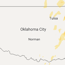
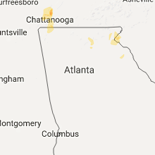
Hail Map for Saturday, April 29, 2017

Number of Impacted Households on 4/29/2017
0
Impacted by 1" or Larger Hail
0
Impacted by 1.75" or Larger Hail
0
Impacted by 2.5" or Larger Hail
Square Miles of Populated Area Impacted on 4/29/2017
0
Impacted by 1" or Larger Hail
0
Impacted by 1.75" or Larger Hail
0
Impacted by 2.5" or Larger Hail


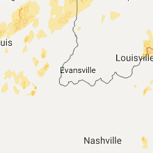


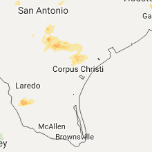


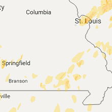


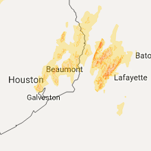

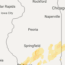


Cities Most Affected by Hail Storms of 4/29/2017
| Hail Size | Demographics of Zip Codes Affected | ||||||
|---|---|---|---|---|---|---|---|
| City | Count | Average | Largest | Pop Density | House Value | Income | Age |
| Marion, VA | 2 | 1.88 | 2.00 | 137 | $70k | $30.2k | 43.3 |
| Adair, OK | 1 | 2.00 | 2.00 | 24 | $67k | $35.4k | 40.7 |
| Limestone, TN | 1 | 1.75 | 1.75 | 97 | $85k | $31.3k | 43.1 |
| Lake Charles, LA | 1 | 1.75 | 1.75 | 248 | $112k | $46.8k | 35.8 |
| Woodsboro, TX | 1 | 1.75 | 1.75 | 2 | $41k | $30.6k | 42.7 |
| Madison, IN | 1 | 1.75 | 1.75 | 105 | $89k | $37.7k | 41.1 |
| Pryor, OK | 1 | 1.75 | 1.75 | 96 | $73k | $32.4k | 37.0 |
Hail and Wind Damage Spotted on 4/29/2017
Filter by Report Type:Hail ReportsWind Reports
States Impacted
Indiana, Texas, Kentucky, Ohio, Illinois, Arkansas, Louisiana, Missouri, Tennessee, Virginia, Oklahoma, Georgia, Mississippi, KansasIndiana
| Local Time | Report Details |
|---|---|
| 8:07 AM EDT | Golf Ball sized hail reported near Madison, IN, 54.5 miles WSW of Cincinnati, OH, mping report. |
| 9:09 PM EDT | Quarter sized hail reported near Covington, IN, 69.4 miles NE of Mattoon, IL, pea to quarter size hail and heavy rain. |
Texas
| Local Time | Report Details |
|---|---|
| 7:10 AM CDT | Quarter sized hail reported near Baytown, TX, 24 miles E of Houston, TX, local broadcast media received a picture report of 1 inch hail in baytown... harris county. |
| 8:14 AM CDT | Quarter sized hail reported near Liberty, TX, 46.3 miles NE of Houston, TX, at a radar estimated time of 814 am cdt... quarter size or one inch hail fell over the city of hardin... in liberty county. |
| 9:16 AM CDT | Quarter sized hail reported near Nome, TX, 42.3 miles WSW of Beaumont, TX, social media video showed quarter size hail in jefferson county between nome and winnie. |
| 11:00 AM CDT | Trees and power lines dow in san augustine county TX, 34.6 miles E of Lufkin, TX |
| 4:30 PM CDT | Quarter sized hail reported near Kemp, TX, 50.6 miles SE of Dallas, TX |
| 4:36 PM CDT | Quarter sized hail reported near Mabank, TX, 49.2 miles SE of Dallas, TX |
| 5:17 PM CDT | Quarter sized hail reported near Commerce, TX, 61.3 miles ENE of Dallas, TX, 1 inch hail reported in south commerce |
| 5:17 PM CDT | Quarter sized hail reported near Klondike, TX, 66.1 miles ENE of Dallas, TX |
| 5:19 PM CDT | Damage on 1255 just ne of canton. trees and power lines down in van zandt county TX, 56.2 miles ESE of Dallas, TX |
| 5:43 PM CDT | Ping Pong Ball sized hail reported near Leonard, TX, 57.7 miles NE of Dallas, TX, bailey volunteer fire department reported |
| 5:50 PM CDT | House collapsed on residents near fm1256 just outside of martins mill in van zandt county TX, 63.9 miles ESE of Dallas, TX |
| 5:50 PM CDT | House collapsed on residents near fm1256 just outside of martins mill in van zandt county TX, 63.9 miles ESE of Dallas, TX |
| 6:20 PM CDT | Ping Pong Ball sized hail reported near Kaufman, TX, 35.6 miles ESE of Dallas, TX, 1 to 1.5 inch hail on 175 se of kaufman |
| 7:28 PM CDT | Ping Pong Ball sized hail reported near Emory, TX, 61.2 miles E of Dallas, TX, report of 1.5 inch hail reported in emory |
| 7:53 PM CDT | Report of large 50 ft tree downed near sulphur springs at hwy 19 in hopkins county TX, 73.6 miles ENE of Dallas, TX |
| 7:59 PM CDT | Half Dollar sized hail reported near Canton, TX, 56.2 miles ESE of Dallas, TX, reports of hail (quarter to half dollar size) reported via social media. |
| 8:10 PM CDT | Trees blocking county rd 3070 and hwy 6 in franklin county TX, 95.4 miles ENE of Dallas, TX |
| 8:42 PM CDT | Trees down along fm 91 in red river county TX, 74.5 miles WSW of Nashville, AR |
| 8:45 PM CDT | Trees down along hwy 37 in red river county TX, 75.9 miles WSW of Nashville, AR |
| 8:47 PM CDT | Trees and power lines dow in wood county TX, 76.4 miles E of Dallas, TX |
| 8:50 PM CDT | Several trees down along fm195 near bagwel in red river county TX, 67 miles SE of Atoka, OK |
| 9:15 PM CDT | Trees down at hwy 80 and state hwy 77 in wood county TX, 86.3 miles E of Dallas, TX |
| 10:42 PM CDT | Half Dollar sized hail reported near Normanna, TX, 57.2 miles NNW of Corpus Christi, TX, mping report from normanna of half-dollar sized hail. |
| 11:42 PM CDT | Half Dollar sized hail reported near Normanna, TX, 57.2 miles NNW of Corpus Christi, TX, mping report from normanna of half-dollar sized hail. |
| 12:00 AM CDT | Golf Ball sized hail reported near Woodsboro, TX, 31 miles N of Corpus Christi, TX, country sherrif received a call of golf ball sized falling in woodsboro |
| 1:12 AM CDT | Storm damage reported in gmz230 county TX, 34.2 miles S of Corpus Christi, TX |
Kentucky
| Local Time | Report Details |
|---|---|
| 8:53 AM EDT | Large limbs or power poles broken... mping repor in oldham county KY, 29.4 miles NNE of Louisville, KY |
| 6:07 PM EDT | Quarter sized hail reported near Springfield, KY, 25.5 miles ESE of Louisville, KY, nickel to quarter size hail reported from a pilot. |
| 6:17 PM EDT | Ping Pong Ball sized hail reported near Danville, KY, 45.3 miles W of Irvine, KY, hail up to ping pong size covering the ground in junction city. |
| 6:21 PM EDT | Quarter sized hail reported near Danville, KY, 44.7 miles W of Irvine, KY |
| 6:40 PM EDT | Half Dollar sized hail reported near Mount Vernon, KY, 34.8 miles SW of Irvine, KY, quarter to half dollar size hail reported via social media. |
| 6:53 PM EDT | Quarter sized hail reported near Irvine, KY, 5.8 miles SSE of Irvine, KY, hail up to quarter size occurred. |
| 6:55 PM EDT | Half Dollar sized hail reported near Lancaster, KY, 35.5 miles W of Irvine, KY, photo via social media. |
| 7:00 PM EDT | Ping Pong Ball sized hail reported near Ravenna, KY, 2.5 miles ESE of Irvine, KY |
| 7:00 PM EDT | Quarter sized hail reported near Irvine, KY, 1.4 miles SSW of Irvine, KY |
| 7:03 PM EDT | Ping Pong Ball sized hail reported near Irvine, KY, 8.6 miles ESE of Irvine, KY |
| 7:11 PM EDT | Quarter sized hail reported near Nicholasville, KY, 30.8 miles WNW of Irvine, KY |
| 8:06 PM EDT | Quarter sized hail reported near Paris, KY, 31.4 miles NNW of Irvine, KY |
| 10:20 PM EDT | Quarter sized hail reported near Virgie, KY, 55.5 miles NNW of Bristol, TN, public report from longfork west of virgie. |
| 11:12 PM EDT | Quarter sized hail reported near Prestonsburg, KY, 67.7 miles E of Irvine, KY, quarter sized hail in lancer. |
Ohio
| Local Time | Report Details |
|---|---|
| 8:59 AM EDT | Tree down near intersection of hunley rd. and clough pike. time estimated by rada in hamilton county OH, 7.2 miles E of Cincinnati, OH |
Illinois
| Local Time | Report Details |
|---|---|
| 9:57 AM CDT | Quarter sized hail reported near Belleville, IL, 17 miles ESE of Saint Louis, MO, quarter size hail at intersection of mascoutah ave and greenmount rd. |
| 3:48 PM CDT | Power line and trees down across the great river rd near lockhaven rd... blocking traffic in both directions. ameren on scene no in jersey county IL, 22.1 miles NNW of Saint Louis, MO |
| 4:05 PM CDT | Numerous tree limbs and a few trees twisted... uprooted and broken around tow in madison county IL, 19.7 miles N of Saint Louis, MO |
| 4:08 PM CDT | Numerous tree limbs down and a few trees twisted and broken. possible tornad in macoupin county IL, 31.4 miles N of Saint Louis, MO |
| 4:08 PM CDT | Trees/power lines down in brighton and medora are in macoupin county IL, 28.6 miles N of Saint Louis, MO |
| 4:25 PM CDT | Metal roof blown off. power poles snapped of in montgomery county IL, 61.4 miles NNE of Saint Louis, MO |
| 4:26 PM CDT | Construction trailer flipped over on its sid in montgomery county IL, 62.9 miles NNE of Saint Louis, MO |
| 4:27 PM CDT | Multiple trees uproote in montgomery county IL, 64.6 miles NNE of Saint Louis, MO |
| 4:28 PM CDT | Tree uprooted onto home causing damag in montgomery county IL, 63.4 miles NNE of Saint Louis, MO |
| 4:48 PM CDT | 2 semi trucks blown over on i-55 between mile markers 72 and 7 in montgomery county IL, 64.2 miles NNE of Saint Louis, MO |
| 4:54 PM CDT | Quarter sized hail reported near Harvel, IL, 61.4 miles NE of Saint Louis, MO |
| 4:54 PM CDT | Storm damage reported in montgomery county IL, 61.4 miles NE of Saint Louis, MO |
| 4:55 PM CDT | Estimated 60-70 mph wind gusts from storms near morrisonville in christian county IL, 58.1 miles W of Mattoon, IL |
| 5:00 PM CDT | Three foot diameter oak tree blown down....along with other trees and power lines blown dow in menard county IL, 49.6 miles SSW of Peoria, IL |
| 5:00 PM CDT | 6 empty train coal cars derailed due to high winds. time estimate in sangamon county IL, 62.6 miles W of Mattoon, IL |
| 5:00 PM CDT | Tree limbs blown down on to a car in logan county IL, 40.9 miles S of Peoria, IL |
| 5:04 PM CDT | Power lines down 1 mile east of litchfiel in montgomery county IL, 47.9 miles NE of Saint Louis, MO |
| 5:06 PM CDT | Storm damage reported in logan county IL, 35.3 miles S of Peoria, IL |
| 5:10 PM CDT | Damage to vegetation and light structural damage. power outages also reported in logan county IL, 40.9 miles S of Peoria, IL |
| 5:15 PM CDT | Several power poles down along 600th ave south of highway 10. two farmsteads with outbuilding damag in logan county IL, 37.8 miles S of Peoria, IL |
| 5:16 PM CDT | Quarter sized hail reported near Kincaid, IL, 55.8 miles W of Mattoon, IL |
| 5:16 PM CDT | Power lines down along highway 48 south of taylorville in christian county IL, 47.3 miles W of Mattoon, IL |
| 5:19 PM CDT | Semi blown over on i-155 at mile marker 4 in logan county IL, 33.4 miles SSE of Peoria, IL |
| 5:45 PM CDT | Storm damage reported in shelby county IL, 23.2 miles WSW of Mattoon, IL |
| 5:46 PM CDT | 3 large trees dow in marion county IL, 61.9 miles E of Saint Louis, MO |
| 5:54 PM CDT | Quarter sized hail reported near Decatur, IL, 39 miles NW of Mattoon, IL, 1 mile southwest of millikin university |
| 6:00 PM CDT | Quarter sized hail reported near Mt Zion, IL, 33.9 miles NW of Mattoon, IL |
| 6:05 PM CDT | 1 house with minor roof damage and 2 barns or outbuildings with roof damage and a power pole ben in marion county IL, 52.5 miles SSW of Mattoon, IL |
| 6:15 PM CDT | Large tree limbs blown down in piatt county IL, 22.5 miles NNW of Mattoon, IL |
| 6:15 PM CDT | Power pole snapped and power lines blown down in de witt county IL, 46.4 miles SE of Peoria, IL |
| 6:15 PM CDT | Trees blown down blocking seven hills road in de witt county IL, 50 miles SE of Peoria, IL |
| 6:30 PM CDT | Power lines were blown down in douglas county IL, 22.6 miles NNE of Mattoon, IL |
| 6:33 PM CDT | Storm damage reported in clay county IL, 59.8 miles SSW of Mattoon, IL |
| 6:37 PM CDT | Mature trees were uprooted and 2 houses were damaged in christian county IL, 47.3 miles W of Mattoon, IL |
| 6:45 PM CDT | Quarter sized hail reported near Tolono, IL, 35.6 miles N of Mattoon, IL, dime to occasional quarter size hail |
| 6:50 PM CDT | Power pole snapped by high wind in cumberland county IL, 16.3 miles SSE of Mattoon, IL |
| 7:05 PM CDT | Tree blown down....fascia blown off garage in moultrie county IL, 21.5 miles NW of Mattoon, IL |
| 7:20 PM CDT | Storm damage reported in edgar county IL, 27.1 miles ENE of Mattoon, IL |
| 7:39 PM CDT | Storm damage reported in richland county IL, 50.2 miles NNW of Evansville, IN |
| 7:45 PM CDT | Quarter sized hail reported near Georgetown, IL, 50.4 miles NE of Mattoon, IL |
| 7:47 PM CDT | Quarter sized hail reported near Georgetown, IL, 50 miles NE of Mattoon, IL |
Arkansas
| Local Time | Report Details |
|---|---|
| 11:45 AM CDT | Highway 319 blocked due to trees down in lonoke county AR, 27.3 miles NE of Little Rock, AR |
| 3:20 PM CDT | Trees and power lines blown down... blocking parts of highway 65. one house sustained structural damag in boone county AR, 70.9 miles S of Springfield, MO |
| 4:35 PM CDT | Multiple trees down within the crossett city limit in ashley county AR, 24.4 miles N of Bastrop, LA |
| 4:36 PM CDT | Trees were blown down in hamburg... including one tree blown down on a house along main stree in ashley county AR, 31.8 miles NNE of Bastrop, LA |
| 4:36 PM CDT | Trees were blown down in north crosset in ashley county AR, 27 miles N of Bastrop, LA |
| 4:45 PM CDT | A few trees down in wilmo in ashley county AR, 27.9 miles NE of Bastrop, LA |
| 5:03 PM CDT | Trees down... one blocking highway 59. time estimated by rada in crawford county AR, 24.6 miles N of Fort Smith, AR |
| 5:05 PM CDT | Power lines down and some building damag in crawford county AR, 18.4 miles N of Fort Smith, AR |
| 5:10 PM CDT | Trees were blown down and power poles were broken in dermot in chicot county AR, 58.7 miles NNE of Bastrop, LA |
| 5:17 PM CDT | Power lines blown down in portlan in ashley county AR, 39.6 miles NE of Bastrop, LA |
| 5:33 PM CDT | Quarter sized hail reported near Waldo, AR, 53 miles SSE of Nashville, AR |
| 5:45 PM CDT | Numerous trees down in and around hope arkansa in hempstead county AR, 21.4 miles SE of Nashville, AR |
| 5:48 PM CDT | Trees down along ashley road 2 near the state line and hwy 13 in ashley county AR, 16.7 miles N of Bastrop, LA |
| 5:55 PM CDT | Several large trees were blown dow in arkansas county AR, 62.1 miles ESE of Little Rock, AR |
| 6:05 PM CDT | Trees and power lines dow in union county AR, 43.8 miles NW of Bastrop, LA |
| 6:15 PM CDT | Trees and power lines dow in union county AR, 43.8 miles NW of Bastrop, LA |
| 6:28 PM CDT | Quarter sized hail reported near Hampton, AR, 61.6 miles NNW of Bastrop, LA, quarter size hail in hampton. |
| 6:45 PM CDT | Quarter sized hail reported near Mountain Home, AR, 78.4 miles SE of Springfield, MO |
| 7:25 PM CDT | Trees and power lines down in cabo in lonoke county AR, 21 miles NE of Little Rock, AR |
| 8:20 PM CDT | Numerous trees were blown dow in montgomery county AR, 44 miles NNE of Nashville, AR |
| 8:27 PM CDT | Quarter sized hail reported near Alexander, AR, 18 miles WSW of Little Rock, AR |
| 8:45 PM CDT | The side of a farm shop building was blown dow in mississippi county AR, 54 miles N of Memphis, TN |
| 8:46 PM CDT | Blytheville airport recorded 58 mp in mississippi county AR, 54.3 miles N of Memphis, TN |
| 9:25 PM CDT | Trees down just north of perry along highway 9 by cypress creek in perry county AR, 35.5 miles NW of Little Rock, AR |
| 9:53 PM CDT | Tree blown down across the highway near the town of parks in scott county AR, 48.3 miles SSE of Fort Smith, AR |
| 10:26 PM CDT | Trees and powerlines down throughout garland county with pearcy being one of the harder hit area in garland county AR, 46.1 miles NE of Nashville, AR |
| 10:49 PM CDT | Trees and powerlines down in casa in perry county AR, 47.6 miles WNW of Little Rock, AR |
| 10:50 PM CDT | Powerlines down on crow mountain in pope county AR, 56.8 miles NW of Little Rock, AR |
| 11:00 PM CDT | Storm spotter measured 60 mph wind gust in faulkner county AR, 23.7 miles NNW of Little Rock, AR |
| 11:20 PM CDT | Tree down on a house in clark county AR, 43.4 miles ENE of Nashville, AR |
| 11:35 PM CDT | Highway 319 blocked due to trees down in lonoke county AR, 27.3 miles NE of Little Rock, AR |
| 11:40 PM CDT | Downed trees blocking roadwa in lonoke county AR, 21.4 miles ENE of Little Rock, AR |
| 11:40 PM CDT | Multiple trees down and blocking the road in lonoke county AR, 25.6 miles NE of Little Rock, AR |
| 11:40 PM CDT | Tree down on a home in sulphur roc in independence county AR, 81.7 miles NNE of Little Rock, AR |
| 11:43 PM CDT | Tree down on a home in malvern in hot spring county AR, 40.6 miles SW of Little Rock, AR |
| 11:50 PM CDT | Powerlines down around glen rose in hot spring county AR, 32.7 miles SW of Little Rock, AR |
| 11:59 PM CDT | Trees were blown dow in lonoke county AR, 26.9 miles NE of Little Rock, AR |
| 11:59 PM CDT | Trees were blown dow in lonoke county AR, 22.8 miles NE of Little Rock, AR |
| 12:01 AM CDT | Large tree down on hwy 229 and front door blown off of haskell police departmen in saline county AR, 26.5 miles SW of Little Rock, AR |
| 12:37 AM CDT | Trees and powerlines down around the higginson area... portion of highway 11 blocked as a resul in white county AR, 44.7 miles NE of Little Rock, AR |
| 12:37 AM CDT | A house sustained major damag in white county AR, 49.3 miles NE of Little Rock, AR |
| 12:38 AM CDT | A trailer was flipped ove in white county AR, 44.5 miles NE of Little Rock, AR |
| 12:44 AM CDT | Several trailers were overturned northwest of georgetown...near highway 36 and nimmo roa in white county AR, 52.9 miles ENE of Little Rock, AR |
| 12:52 AM CDT | Trees and powerlines down in georgetown... including a tree down on a hom in white county AR, 53.7 miles ENE of Little Rock, AR |
| 1:05 AM CDT | Numerous trees uprooted. fence blown dow in lawrence county AR, 73.2 miles NW of Memphis, TN |
| 1:24 AM CDT | Trees and powerlines down. debris in roa in poinsett county AR, 58 miles NW of Memphis, TN |
| 1:33 AM CDT | Trees down on hwy 163 blocking road in craighead county AR, 55.8 miles NW of Memphis, TN |
| 1:43 AM CDT | Storm damage reported in craighead county AR, 49.9 miles NW of Memphis, TN |
| 1:47 AM CDT | Power poles down in craighead county AR, 51.4 miles NNW of Memphis, TN |
| 1:54 AM CDT | Power pole and power lines down in craighead county AR, 53.6 miles NNW of Memphis, TN |
| 2:26 AM CDT | Storm damage reported in mississippi county AR, 54.3 miles N of Memphis, TN |
Louisiana
| Local Time | Report Details |
|---|---|
| 12:35 PM CDT | Trees dow in natchitoches county LA, 72.4 miles SSE of Shreveport, LA |
| 1:15 PM CDT | Trees and power lines down county wide. small hai in sabine county LA, 74.7 miles E of Lufkin, TX |
| 1:40 PM CDT | Trees and power lines dow in sabine county LA, 67.1 miles SSE of Shreveport, LA |
| 2:05 PM CDT | Trees and power lines down. tree on a mobile hom in natchitoches county LA, 62.6 miles SSE of Shreveport, LA |
| 2:24 PM CDT | Trees dow in natchitoches county LA, 63.5 miles SE of Shreveport, LA |
| 2:36 PM CDT | Large tree limbs down across the road between hart rd and sandy point r in natchitoches county LA, 59.7 miles SE of Shreveport, LA |
| 3:15 PM CDT | Numerous trees down on firetower r in jackson county LA, 58.9 miles SW of Bastrop, LA |
| 3:30 PM CDT | Numerous trees down on hill street r in jackson county LA, 60.3 miles SW of Bastrop, LA |
| 4:00 PM CDT | Cable down across intersection of hwy 2 and hwy 3. power lines and trees dow in bossier county LA, 27.4 miles N of Shreveport, LA |
| 6:45 PM CDT | Quarter sized hail reported near Lake Charles, LA, 28.4 miles E of Beaumont, TX, public reported estimated quarter sized hail in sw lake charles via social media. |
| 7:05 PM CDT | Quarter sized hail reported near Sulphur, LA, 24.4 miles ENE of Beaumont, TX, nws meteorologist reported quarter sized hail in sulphur. |
| 7:05 PM CDT | Quarter sized hail reported near Lake Charles, LA, 35.1 miles ENE of Beaumont, TX, former nws employee reported quarter sized hail near moss bluff. |
| 7:07 PM CDT | Quarter sized hail reported near Westlake, LA, 30.5 miles ENE of Beaumont, TX, nws employee reported quarter sized hail in westlake. |
| 7:07 PM CDT | Half Dollar sized hail reported near Lake Charles, LA, 35.1 miles ENE of Beaumont, TX, former nws employee reported half-dollar sized hail near moss bluff. |
| 7:10 PM CDT | Quarter sized hail reported near Lake Charles, LA, 36.3 miles ENE of Beaumont, TX, public reported photos of estimated quarter size hail via social media. |
| 7:10 PM CDT | Golf Ball sized hail reported near Lake Charles, LA, 36 miles ENE of Beaumont, TX, nws employee reported golf ball sized hail near moss bluff. |
| 7:50 PM CDT | Quarter sized hail reported near Pitkin, LA, 74.1 miles NW of Lafayette, LA, public reported quarter sized hail near strothers country store. |
| 7:53 PM CDT | Quarter sized hail reported near Reeves, LA, 51 miles NE of Beaumont, TX, public reported nickel to quarter sized hail in reeves. |
| 8:52 PM CDT | Quarter sized hail reported near Oberlin, LA, 52.2 miles WNW of Lafayette, LA, ham radio operator reported quarter sized hail in oberlin. |
| 8:55 PM CDT | Ping Pong Ball sized hail reported near Oberlin, LA, 52.2 miles WNW of Lafayette, LA, public reported pingpong ball sized hail near oberlin. |
| 2:14 AM CDT | Half Dollar sized hail reported near Jennings, LA, 40.7 miles W of Lafayette, LA, sporadic half dollar size hail falling. |
| 2:45 AM CDT | Trees reported down parish wide. power out in quitma in jackson county LA, 52.7 miles SW of Bastrop, LA |
| 3:23 AM CDT | Trees down and several homes with damage to porches off ketchum road west of sike in winn county LA, 60.4 miles SW of Bastrop, LA |
| 3:24 AM CDT | Trees down in and on the gaars mills road are in winn county LA, 59.7 miles SW of Bastrop, LA |
| 4:02 AM CDT | Tree down on highway 3 in ouachita county LA, 35.5 miles SW of Bastrop, LA |
| 4:25 AM CDT | Trees down ne dodso in winn county LA, 62.7 miles SW of Bastrop, LA |
| 4:55 AM CDT | Trees down along hwy 425 n... possible continuation of tornado w of oak ridg in morehouse county LA, 12.2 miles SE of Bastrop, LA |
Missouri
| Local Time | Report Details |
|---|---|
| 2:13 PM CDT | Quarter sized hail reported near Ava, MO, 35.8 miles ESE of Springfield, MO |
| 3:30 PM CDT | Cars and boats overturned at intersection of dwyer and church roads. at least 5 homes structurally damaged. numerous trees and power lines dow in st. charles county MO, 24.1 miles NW of Saint Louis, MO |
| 3:39 PM CDT | Quarter sized hail reported near Bridgeton, MO, 15.9 miles NW of Saint Louis, MO |
| 3:51 PM CDT | 1-foot diameter tree topple in st. louis county MO, 13.6 miles NNW of Saint Louis, MO |
| 2:07 AM CDT | Building destroyed and home with windows blown out and a tree in the house in the town of cotton plan in dunklin county MO, 64.2 miles N of Memphis, TN |
| 2:19 AM CDT | Several mobile homes damaged in town of goble in pemiscot county MO, 70.6 miles N of Memphis, TN |
Tennessee
| Local Time | Report Details |
|---|---|
| 3:58 PM EDT | Ping Pong Ball sized hail reported near Greeneville, TN, 44.3 miles SW of Bristol, TN, pea sized to ping pong ball sized hail. |
| 4:10 PM EDT | Half Dollar sized hail reported near Afton, TN, 38.8 miles SW of Bristol, TN, quarter to half dollar size hail reported between tusculium |
| 4:15 PM EDT | Golf Ball sized hail reported near Limestone, TN, 34.4 miles SW of Bristol, TN |
| 6:12 PM EDT | Several trees and power lines down in south mcdonal in bradley county TN, 19.2 miles ENE of Chattanooga, TN |
| 5:35 PM CDT | A few trees down across southern end of sequatchie county south of dunla in sequatchie county TN, 22.8 miles NNW of Chattanooga, TN |
| 7:30 PM EDT | Trees and power lines down on signal mountain along the hamilton/sequatchie county lin in hamilton county TN, 10 miles N of Chattanooga, TN |
| 8:10 PM CDT | Social media report of a tree down in the tanglewood community. time estimated by rada in smith county TN, 44.6 miles E of Nashville, TN |
| 8:14 PM CDT | Quarter sized hail reported near Celina, TN, 73.8 miles ENE of Nashville, TN |
| 3:08 AM CDT | 1 inch tree limbs broken and shingles blown off roo in obion county TN, 36.5 miles NW of Mc Kenzie, TN |
| 4:25 AM CDT | Tree down near intersection of india and mcintosh roa in henry county TN, 19.5 miles NE of Mc Kenzie, TN |
Virginia
| Local Time | Report Details |
|---|---|
| 4:18 PM EDT | Quarter sized hail reported near Rural Retreat, VA, 56.9 miles ENE of Bristol, TN |
| 4:57 PM EDT | Quarter sized hail reported near Wytheville, VA, 67.2 miles ENE of Bristol, TN |
| 5:20 PM EDT | Quarter sized hail reported near Marion, VA, 43.3 miles ENE of Bristol, TN |
| 5:28 PM EDT | Hen Egg sized hail reported near Marion, VA, 43.3 miles ENE of Bristol, TN |
| 5:33 PM EDT | Quarter sized hail reported near Covington, VA, 35.2 miles N of Roanoke, VA, most was dime sized. |
| 5:35 PM EDT | Golf Ball sized hail reported near Marion, VA, 44.6 miles ENE of Bristol, TN |
| 5:54 PM EDT | Quarter sized hail reported near Chilhowie, VA, 32.8 miles ENE of Bristol, TN, pea to quarter sized hail. |
Oklahoma
| Local Time | Report Details |
|---|---|
| 4:00 PM CDT | Quarter sized hail reported near Boswell, OK, 28.6 miles SSE of Atoka, OK, pea to quarter size hail in boswell |
| 4:10 PM CDT | Quarter sized hail reported near Hartshorne, OK, 45.5 miles NE of Atoka, OK |
| 4:15 PM CDT | Several trees down in and around sallisaw. time estimated by rada in sequoyah county OK, 21.4 miles WNW of Fort Smith, AR |
| 6:15 PM CDT | Golf Ball sized hail reported near Pryor, OK, 44.2 miles ENE of Tulsa, OK, near the intersection of 440 west and 435 north |
| 6:25 PM CDT | Hen Egg sized hail reported near Adair, OK, 47.6 miles ENE of Tulsa, OK, relayed via social media and associated picture. |
| 7:03 PM CDT | Numerous trees dow in mccurtain county OK, 44.9 miles W of Nashville, AR |
| 9:03 PM CDT | Numerous large tree limbs down. a private weather station measured a 66 mph wind gust just northwest of eagletow in mccurtain county OK, 44.9 miles W of Nashville, AR |
Georgia
| Local Time | Report Details |
|---|---|
| 6:25 PM EDT | Trained spotter reported numerous trees down blocking roads on long laurel ridge d in rabun county GA, 46.3 miles W of Greenville, SC |
Mississippi
| Local Time | Report Details |
|---|---|
| 7:35 PM CDT | Sustained 36 kts gusting to 55 kts equaling 41 mph gusting to 63 mp in tunica county MS, 36.8 miles SSW of Memphis, TN |
| 8:30 PM CDT | 20 or more power poles down in the wilson mills area of wall in desoto county MS, 14.5 miles SSW of Memphis, TN |
| 9:09 PM CDT | Quarter sized hail reported near Southaven, MS, 12.7 miles SSE of Memphis, TN, quarter sized hail reported near pleasant hill and getwell. |
| 9:15 PM CDT | Quarter sized hail reported near Olive Branch, MS, 18.5 miles SE of Memphis, TN, quarter sized hail falling at goodman road and pleasant hill road. |
Kansas
| Local Time | Report Details |
|---|---|
| 8:00 PM CDT | Roofs blown off two buildings... one out building destoryed and a livestock trailer moved several feet. delayed repor in labette county KS, 43 miles S of Chanute, KS |
| 8:28 PM CDT | Storm damage reported in labette county KS, 25.8 miles SSE of Chanute, KS |
Connect with Interactive Hail Maps