

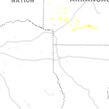
Hail Map for Thursday, July 21, 2022

Number of Impacted Households on 7/21/2022
0
Impacted by 1" or Larger Hail
0
Impacted by 1.75" or Larger Hail
0
Impacted by 2.5" or Larger Hail
Square Miles of Populated Area Impacted on 7/21/2022
0
Impacted by 1" or Larger Hail
0
Impacted by 1.75" or Larger Hail
0
Impacted by 2.5" or Larger Hail


Cities Most Affected by Hail Storms of 7/21/2022
| Hail Size | Demographics of Zip Codes Affected | ||||||
|---|---|---|---|---|---|---|---|
| City | Count | Average | Largest | Pop Density | House Value | Income | Age |
| Bismarck, ND | 4 | 2.13 | 2.50 | 538 | $75k | $31.1k | 38.1 |
| Moffit, ND | 1 | 2.00 | 2.00 | 1 | $37k | $36.9k | 48.6 |
| Jamestown, ND | 1 | 1.75 | 1.75 | 39 | $71k | $33.6k | 42.3 |
| Napoleon, ND | 1 | 1.75 | 1.75 | 2 | $34k | $29.4k | 48.4 |
| Montpelier, ND | 1 | 1.75 | 1.75 | 2 | $28k | $30.0k | 43.6 |
| Irasburg, VT | 1 | 1.75 | 1.75 | 24 | $79k | $35.0k | 43.2 |
| Orleans, VT | 1 | 1.75 | 1.75 | 36 | $70k | $28.1k | 43.1 |
| Strasburg, ND | 1 | 1.75 | 1.75 | 1 | $37k | $26.4k | 53.2 |
| Greenville, ME | 1 | 1.75 | 1.75 | 1 | $85k | $30.8k | 53.0 |
| Eureka, SD | 1 | 1.75 | 1.75 | 1 | $20k | $22.4k | 58.4 |
| Meredith, NH | 1 | 1.75 | 1.75 | 160 | $137k | $42.7k | 48.7 |
| Keene, NH | 1 | 1.75 | 1.75 | 387 | $103k | $37.4k | 35.4 |
Hail and Wind Damage Spotted on 7/21/2022
Filter by Report Type:Hail ReportsWind Reports
States Impacted
Georgia, Vermont, New York, New Jersey, North Carolina, New Hampshire, Connecticut, Massachusetts, Maryland, Virginia, Alabama, Arkansas, Maine, Texas, Delaware, Oklahoma, North Dakota, Michigan, Arizona, South Dakota, Nebraska, Indiana, New MexicoGeorgia
| Local Time | Report Details |
|---|---|
| 9:56 AM EDT | Trees and powerlines down near intersection of buford hwy ne and laventure d in dekalb county GA, 10.8 miles NNE of Atlanta, GA |
| 11:21 AM EDT | Tree on house near intersection of vandenburg dr and inverness d in carroll county GA, 30.5 miles W of Atlanta, GA |
| 11:26 AM EDT | Tree down in roadway on oak grove rd near spinks r in carroll county GA, 37.7 miles W of Atlanta, GA |
| 11:33 AM EDT | Tree down in roadway on mote rd near pleasant ridge r in carroll county GA, 41.1 miles WSW of Atlanta, GA |
| 11:46 AM EDT | Tree down on maple st near howell r in carroll county GA, 42.1 miles WSW of Atlanta, GA |
| 2:46 PM EDT | Quarter sized hail reported near Lagrange, GA, 40.8 miles NE of Auburn, AL, quarter-size hail reported near the intersection of new franklin rd and private st. |
| 4:25 PM EDT | Tree down on ramah church rd near the intersection of peacock r in lamar county GA, 53.3 miles SSE of Atlanta, GA |
Vermont
| Local Time | Report Details |
|---|---|
| 12:11 PM EDT | Tree down in east fairfield and pea size hai in franklin county VT, 27.3 miles NE of Burlington, VT |
| 12:34 PM EDT | Quarter sized hail reported near Albany, VT, 44.7 miles ENE of Burlington, VT |
| 12:38 PM EDT | Half Dollar sized hail reported near Albany, VT, 44.7 miles ENE of Burlington, VT |
| 12:48 PM EDT | Large trees blocking lake region road... just west of i-9 in orleans county VT, 53.3 miles ENE of Burlington, VT |
| 12:50 PM EDT | Golf Ball sized hail reported near Irasburg, VT, 51.2 miles ENE of Burlington, VT |
| 12:50 PM EDT | Golf Ball sized hail reported near Orleans, VT, 55 miles ENE of Burlington, VT |
| 1:08 PM EDT | Quarter sized hail reported near East Charleston, VT, 65 miles ENE of Burlington, VT |
| 1:15 PM EDT | Trees and power lines down in windsor county VT, 79.3 miles SSE of Burlington, VT |
| 1:30 PM EDT | Large tree branch on route 104 between fairfax and cambridge in chittenden county VT, 17.6 miles NE of Burlington, VT |
| 1:38 PM EDT | Tree down on power lines in orange county VT, 66.6 miles SE of Burlington, VT |
| 1:45 PM EDT | 1 tree down in southern portion of manchester and small hail in the mid portion of manchester in bennington county VT, 50.2 miles ENE of Schenectady, NY |
| 1:51 PM EDT | Trees and power lines down in essex county VT, 89.9 miles ENE of Burlington, VT |
| 1:54 PM EDT | Quarter sized hail reported near Bradford, VT, 61.4 miles ESE of Burlington, VT |
| 2:16 PM EDT | Tree on power lines causing outage in concord and waterford area in essex county VT, 65.5 miles E of Burlington, VT |
| 2:18 PM EDT | Trees and wires down in waterford area in caledonia county VT, 63.3 miles E of Burlington, VT |
| 2:45 PM EDT | Report of a snapped pine tree at a residence on eastern side of newar in caledonia county VT, 68.2 miles ENE of Burlington, VT |
| 2:54 PM EDT | Trees down in essex county VT, 82 miles E of Burlington, VT |
| 3:45 PM EDT | Tree downed near route 7 on the charlotte and ferrisburg town lin in chittenden county VT, 14.9 miles S of Burlington, VT |
| 3:45 PM EDT | Reports of snapped trees along greenbush r in chittenden county VT, 14.3 miles S of Burlington, VT |
| 3:52 PM EDT | Trees and wires down in monkon ridge are in addison county VT, 17.3 miles S of Burlington, VT |
| 3:57 PM EDT | Tree down... time estimated by rada in addison county VT, 18.9 miles SSE of Burlington, VT |
| 4:05 PM EDT | Tree down... time estimated by rada in addison county VT, 18.9 miles SSE of Burlington, VT |
| 4:09 PM EDT | Trees down on mayo rd. time estimated by rada in chittenden county VT, 14.5 miles SE of Burlington, VT |
| 4:45 PM EDT | Trees down on route 22a in addison county VT, 47.6 miles S of Burlington, VT |
| 4:48 PM EDT | Powerlines down on route 73 in addison county VT, 46.8 miles S of Burlington, VT |
| 4:59 PM EDT | Trees and power lines down in brandon... whiting... and leiceste in addison county VT, 42.2 miles S of Burlington, VT |
| 5:55 PM EDT | 1 large tree down on lines and numerous other small limbs throughout brighton state par in essex county VT, 70.6 miles ENE of Burlington, VT |
| 6:22 PM EDT | Tree down on wire in windsor county VT, 69.2 miles SE of Burlington, VT |
New York
| Local Time | Report Details |
|---|---|
| 12:30 PM EDT | Tree down on old meadow road in montgomery county NY, 39.7 miles WNW of Schenectady, NY |
| 12:32 PM EDT | West main street in st. johnsvile- wires down with a fire in the backyar in montgomery county NY, 39.7 miles WNW of Schenectady, NY |
| 12:36 PM EDT | Small tree snapped and blocking spring r in saratoga county NY, 19.6 miles NNE of Schenectady, NY |
| 12:40 PM EDT | Minor street flooding; quarter-sized hail (1 inch) observed at washington county fair grounds in washington county NY, 27.9 miles NE of Schenectady, NY |
| 12:48 PM EDT | Wind and sheets of rain from the west; 4 minutes later from the east; now from the west again; 50-60mph with some hail in saratoga county NY, 21.9 miles NE of Schenectady, NY |
| 12:48 PM EDT | Tree down blocking roadway- 884 us-4 in saratoga county NY, 19.6 miles NNE of Schenectady, NY |
| 12:54 PM EDT | 877 us-4 multiple trees and wires down in saratoga county NY, 26.7 miles NE of Schenectady, NY |
| 12:54 PM EDT | Trees and wires down at 201 hanehan r in saratoga county NY, 23.8 miles NE of Schenectady, NY |
| 1:00 PM EDT | Heavy rain; wind gusts>30mph; 1cm hail in washington county NY, 29.5 miles NE of Schenectady, NY |
| 1:12 PM EDT | Tree down in the parking lot at the bronx zo in bronx county NY, 12 miles NNE of Brooklyn, NY |
| 1:15 PM EDT | Quarter sized hail reported near Irvington, NY, 24.8 miles NNE of Brooklyn, NY |
| 1:17 PM EDT | County route 313 between jackson and salem- large tree down on car in washington county NY, 39.4 miles ENE of Schenectady, NY |
| 1:17 PM EDT | Quarter sized hail reported near Bronx, NY, 10.6 miles NNE of Brooklyn, NY, report from mping: quarter (1.00 in.). |
| 1:20 PM EDT | Quarter sized hail reported near Bronx, NY, 11.1 miles NE of Brooklyn, NY, corrects time of previous hail report from 1 ssw parkchester. |
| 1:22 PM EDT | Quarter sized hail reported near Bronx, NY, 11.1 miles NE of Brooklyn, NY |
| 1:24 PM EDT | 12 county route 61- car crushed by tree in washington county NY, 39.6 miles NE of Schenectady, NY |
| 1:41 PM EDT | Wires down on northern blvd near route 107. time estimated by rada in nassau county NY, 23.3 miles ENE of Brooklyn, NY |
| 1:41 PM EDT | Tree down... downed wires and road closure on ny 172 both directions between darlington road and mclain street all lanes blocke in westchester county NY, 37.8 miles NNE of Brooklyn, NY |
| 1:49 PM EDT | Tree down and road closure on ny 138 both directions at increase miller road (lewisboro) all lanes of 2 lanes blocke in westchester county NY, 45.5 miles NNE of Brooklyn, NY |
| 1:54 PM EDT | Tree down and road closure on ny 22 both directions at hardscrabble rd (croton falls) all lanes of 2 lanes blocke in westchester county NY, 47.9 miles NNE of Brooklyn, NY |
| 1:59 PM EDT | Tree down and road closure on ny 22 northbound at reed farm drive (southeast) alternate lanes of 2 lanes blocke in putnam county NY, 50.2 miles NNE of Brooklyn, NY |
| 2:30 PM EDT | Rt. 22 just south of millerton- pea sized hail in a short burst in dutchess county NY, 63.3 miles SSE of Schenectady, NY |
| 2:36 PM EDT | Tree down over parts of 372 between greenwich and cambridge in washington county NY, 30.6 miles NE of Schenectady, NY |
| 2:45 PM EDT | Power lines down and power lost. 53 mph wind gust measure in nassau county NY, 26.3 miles ENE of Brooklyn, NY |
| 2:47 PM EDT | Ping Pong Ball sized hail reported near Hicksville, NY, 24.8 miles ENE of Brooklyn, NY, report from mping: ping pong ball (1.50 in.). |
| 3:19 PM EDT | Quarter sized hail reported near Brentwood, NY, 37.5 miles ENE of Brooklyn, NY, reported at lie and commack rd. |
| 3:21 PM EDT | Quarter sized hail reported near Farmingville, NY, 50.9 miles ENE of Brooklyn, NY |
| 3:28 PM EDT | Ping Pong Ball sized hail reported near Central Islip, NY, 42.1 miles E of Brooklyn, NY |
| 3:44 PM EDT | Large branches dow in suffolk county NY, 34.5 miles E of Brooklyn, NY |
| 4:29 PM EDT | Trees down blocking lie service road near route 11 in suffolk county NY, 41.7 miles ENE of Brooklyn, NY |
New Jersey
| Local Time | Report Details |
|---|---|
| 12:40 PM EDT | Tree on a house and car on east passaic and wachung ave. time estimated from rada in essex county NJ, 13.2 miles NW of Brooklyn, NY |
| 12:50 PM EDT | Trees and wires down on rairoad ave. time estimated from rada in bergen county NJ, 10 miles NNW of Brooklyn, NY |
| 3:28 PM EDT | Trees down on wires/equipment. time estimated via rada in camden county NJ, 74.6 miles SW of Brooklyn, NY |
| 3:30 PM EDT | Evesham twp. pd reports wires down on north elmwood road near route 70. time estimated via rada in burlington county NJ, 71.6 miles SW of Brooklyn, NY |
North Carolina
| Local Time | Report Details |
|---|---|
| 1:00 PM EDT | Trees down on nc 109 at toms creek church rd and mountain view d in davidson county NC, 50.6 miles NE of Charlotte, NC |
| 1:05 PM EDT | Trees down at guilford colleg in guilford county NC, 73 miles WNW of Raleigh, NC |
| 1:13 PM EDT | Trees down at horse pen creek rd and new garden r in guilford county NC, 73.1 miles WNW of Raleigh, NC |
| 1:15 PM EDT | Several trees down... some on power line in guilford county NC, 70.9 miles WNW of Raleigh, NC |
| 1:24 PM EDT | Trees down near northern guilford high schoo in guilford county NC, 71.6 miles WNW of Raleigh, NC |
| 1:38 PM EDT | 2 trees down in the prospect hill are in caswell county NC, 44.8 miles NW of Raleigh, NC |
| 2:17 PM EDT | Two trees down along law road... south of pelha in caswell county NC, 62 miles SSE of Roanoke, VA |
| 2:20 PM EDT | Corrects the time of a previous tstm wnd dmg report from 2 w roxboro. tree on power lines at newell dr and old salem r in person county NC, 47.1 miles NNW of Raleigh, NC |
| 2:22 PM EDT | Trees down in the osmond are in caswell county NC, 54.2 miles NNW of Raleigh, NC |
| 2:35 PM EDT | 1 tree down at 3330 saybrook dr in graha in alamance county NC, 43.9 miles WNW of Raleigh, NC |
| 2:37 PM EDT | Tree down at e little john ln and durham st extensio in alamance county NC, 52.6 miles WNW of Raleigh, NC |
| 2:42 PM EDT | Multiple trees down at 695 knott r in person county NC, 43.9 miles NNW of Raleigh, NC |
| 2:47 PM EDT | Tree down at coble mill rd and west greensboro chapel hill r in alamance county NC, 47.7 miles W of Raleigh, NC |
| 3:22 PM EDT | 1 tree down at 2154 nc highway 96 south... creedmoo in granville county NC, 24 miles N of Raleigh, NC |
| 3:40 PM EDT | 1 tree down on nc 5 in franklin county NC, 24 miles NNE of Raleigh, NC |
| 4:09 PM EDT | Tree on power lines at newell dr and old salem r in person county NC, 47.1 miles NNW of Raleigh, NC |
| 4:55 PM EDT | 1 tree down at hunter hill rd and n halifax r in nash county NC, 46.1 miles ENE of Raleigh, NC |
| 5:03 PM EDT | 1 tree down at watson seed farm rd and ethridge r in nash county NC, 57.4 miles ENE of Raleigh, NC |
New Hampshire
| Local Time | Report Details |
|---|---|
| 1:12 PM EDT | Quarter sized hail reported near Pittsburg, NH, 98.1 miles ENE of Burlington, VT, severe hail of 1 inch reported in pittsburgh with picture evidence. |
| 1:50 PM EDT | Ping Pong Ball sized hail reported near Claremont, NH, 84.9 miles SSE of Burlington, VT, reported by weather spotter: observed hail between 1.25 inches and 1.5 inches; in w. claremont. occurred at approx 1:50pm. |
| 1:56 PM EDT | Large tree down on shoulder of nh highway 10 north of lyme. diameter ~12 inches. time estimated by rada in grafton county NH, 69.2 miles SE of Burlington, VT |
| 2:04 PM EDT | Tree down-reported by new england 511. time estimated by rada in grafton county NH, 66.5 miles SE of Burlington, VT |
| 2:12 PM EDT | Quarter sized hail reported near Pittsburg, NH, 96.7 miles ENE of Burlington, VT, corrected previous report for time. one inch hail reported in pittsburg... nh. picture posted on social media. |
| 2:12 PM EDT | Ping Pong Ball sized hail reported near North Haverhill, NH, 65.2 miles ESE of Burlington, VT, measured hail between 1.3-1.5 inches in diameter. hail lasted 6 minutes and covered some grassy areas. |
| 2:15 PM EDT | Numerous trees down on west rd east of us hwy 3 split. photos on social medi in coos county NH, 93.1 miles ENE of Burlington, VT |
| 2:28 PM EDT | Several large branches down across nh highway 10 in croydon. time estimated by rada in sullivan county NH, 88.2 miles SE of Burlington, VT |
| 2:32 PM EDT | Half Dollar sized hail reported near Hinsdale, NH, 74.3 miles E of Schenectady, NY, reported by weather spotter: trained spotter observed 1.25 inch hail in downtown hinsdale near intersection of nh 119 and nh 63. |
| 2:36 PM EDT | Wires down. time estimated by rada in grafton county NH, 74.3 miles W of Portland, ME |
| 2:36 PM EDT | Ping Pong Ball sized hail reported near Bristol, NH, 74.4 miles W of Portland, ME, reported by amateur radio: ping pong sized hail fell for about minutes. observed from route 3a. reports of some minor damage. time estimated by radar. |
| 2:38 PM EDT | Wires down. time estimated by rada in carroll county NH, 39.8 miles WNW of Portland, ME |
| 2:39 PM EDT | Non-nws meteorologist reported trees on wires. time estimated by rada in belknap county NH, 69.9 miles W of Portland, ME |
| 2:40 PM EDT | Non-nws meteorologist reported tree down on interstate 93. time estimated by rada in belknap county NH, 69.8 miles W of Portland, ME |
| 2:54 PM EDT | Tree on wires. time estimated by rada in grafton county NH, 76.2 miles W of Portland, ME |
| 2:56 PM EDT | Half Dollar sized hail reported near Swanzey, NH, 83.1 miles E of Schenectady, NY, hail as big as half dollars fell at the market basket on the south side of keene. |
| 2:58 PM EDT | Trees and wires down. time estimated by rada in cheshire county NH, 89.7 miles E of Schenectady, NY |
| 3:00 PM EDT | Tree down on nh-25. time estimated by rada in carroll county NH, 58.9 miles W of Portland, ME |
| 3:02 PM EDT | Golf Ball sized hail reported near Keene, NH, 86.7 miles E of Schenectady, NY, reported by weather spotter. golf ball-sized hail caused damage to minor vehicle hood. hail fell on east side of keene just off of nh hwy 101. time estimated by radar. |
| 3:04 PM EDT | Multiple trees dow in carroll county NH, 55.3 miles W of Portland, ME |
| 3:05 PM EDT | Winona rd in new hampton is closed due to downed wires and tree in belknap county NH, 65.8 miles W of Portland, ME |
| 3:06 PM EDT | Multiple trees down. time estimated by rive in carroll county NH, 54.3 miles W of Portland, ME |
| 3:06 PM EDT | Delayed report. multiple trees down at bald peak cc. via facebook. time estimated via rada in carroll county NH, 53.9 miles W of Portland, ME |
| 3:10 PM EDT | Tree on line. time estimated by rada in cheshire county NH, 90.8 miles NNW of Providence, RI |
| 3:12 PM EDT | Golf Ball sized hail reported near Meredith, NH, 68.1 miles W of Portland, ME, observed golf ball sized hail north of sanbornton on pinnacle hill rd. winds knocked down numerous branches and blew around loose objects. time estimated by radar. |
| 3:14 PM EDT | Trees down. time estimated by rada in cheshire county NH, 89.1 miles NNW of Providence, RI |
| 3:22 PM EDT | Half Dollar sized hail reported near Center Ossipee, NH, 45.3 miles W of Portland, ME, reported by weather spotter: hail lasted for about 5 minutes. most stones were quarter-sized... but quite a few as large as half dollars. |
| 3:24 PM EDT | Ping Pong Ball sized hail reported near Pittsburg, NH, 95.4 miles ENE of Burlington, VT, 1.5 inchers; hail fell for 5 mins south of clarksville. damage to a shed. strong winds blew down branches. approximately 2:10pm. |
| 3:26 PM EDT | Quarter sized hail reported near Fitzwilliam, NH, 76.7 miles NNW of Providence, RI, hailstones the size of quarters in fitzwilliam along rte 12n. time estimated by radar. |
| 3:28 PM EDT | Trees down in roadway. time estimated by rada in hillsborough county NH, 87.5 miles NNW of Providence, RI |
| 3:28 PM EDT | Trees and wires down in roadway. time estimated by rada in hillsborough county NH, 88.5 miles NNW of Providence, RI |
| 3:30 PM EDT | Tree dow in carroll county NH, 44.8 miles W of Portland, ME |
| 3:32 PM EDT | Branches and a few small trees down along a stretch of nh highway 119. time estimated by rada in cheshire county NH, 73.5 miles NNW of Providence, RI |
| 3:34 PM EDT | Trees and wires down. time estimated by rada in hillsborough county NH, 88.2 miles NNW of Providence, RI |
| 3:38 PM EDT | Delayed report. multiple trees and large limbs down. via twitter with pictures. time estimated via rada in carroll county NH, 41.1 miles W of Portland, ME |
| 3:40 PM EDT | Wires down. time estimated by rada in carroll county NH, 38.2 miles W of Portland, ME |
| 3:54 PM EDT | Wires down. time estimated by rada in hillsborough county NH, 65 miles NNW of Providence, RI |
| 3:58 PM EDT | Quarter sized hail reported near New Boston, NH, 81.1 miles N of Providence, RI, 1-inch hail lasted 5-6 minutes. gusty winds blew down several branches across the area. time estimated by radar. |
| 4:04 PM EDT | Wires down. time estimated by rada in hillsborough county NH, 65.5 miles NNW of Providence, RI |
| 4:05 PM EDT | Wires down. time estimated by rada in hillsborough county NH, 64.7 miles NNW of Providence, RI |
| 4:08 PM EDT | Hl159 reported trees and wires down. time estimated by rada in hillsborough county NH, 63.8 miles NNW of Providence, RI |
| 4:08 PM EDT | Telephone pole blown down. time estimated by rada in hillsborough county NH, 62.5 miles NNW of Providence, RI |
| 4:13 PM EDT | Five snapped power poles on hooksett rd. time estimated by rada in merrimack county NH, 72.6 miles SW of Portland, ME |
| 4:14 PM EDT | Wires down. time estimated by rada in merrimack county NH, 72.2 miles WSW of Portland, ME |
| 4:14 PM EDT | Trees and wires down on roadway. time estimated by rada in hillsborough county NH, 87.3 miles NNW of Providence, RI |
| 4:18 PM EDT | Tree on wire. time estimated by rada in grafton county NH, 75.9 miles W of Portland, ME |
| 4:18 PM EDT | Wires down. time estimated by rada in merrimack county NH, 71.3 miles SW of Portland, ME |
| 4:20 PM EDT | Wires down. time estimated by rada in merrimack county NH, 73 miles SW of Portland, ME |
| 4:21 PM EDT | Thunderstorm winds knocked down several branches... blew over barrels near the hollis post offic in hillsborough county NH, 63.9 miles N of Providence, RI |
| 4:24 PM EDT | Quarter sized hail reported near Hooksett, NH, 72.5 miles SW of Portland, ME, storm w/ gusty winds and 1-inch hail impacted south hooksett east of route 28. time estimated by radar. |
| 4:30 PM EDT | Half Dollar sized hail reported near Brookline, NH, 64.6 miles NNW of Providence, RI, hail fell in west brookline just west of highway 31 at the entrance to potanipo lake. time estimated by radar. |
| 4:30 PM EDT | Wires down. time estimated by rada in hillsborough county NH, 63.1 miles NNW of Providence, RI |
| 4:34 PM EDT | Public reported 1 inch hail. time estimated by rada in hillsborough county NH, 63.9 miles N of Providence, RI |
| 4:38 PM EDT | Tree on line. time estimated by rada in hillsborough county NH, 63.9 miles N of Providence, RI |
| 4:45 PM EDT | Quarter sized hail reported near Hampstead, NH, 71 miles SW of Portland, ME, observed 1 inch hail near wash pond in hampstead at 4:45. |
| 4:50 PM EDT | Wires down. time estimated by rada in carroll county NH, 58.1 miles WNW of Portland, ME |
| 5:04 PM EDT | Report from mping: 1-inch tree limbs broken; shingles blown off. time estimated by rada in rockingham county NH, 61.7 miles SW of Portland, ME |
| 5:10 PM EDT | Several trees and wires down. time estimated by rada in rockingham county NH, 58.8 miles SW of Portland, ME |
| 5:14 PM EDT | Large tree down... wrapped in wires. time estimated by rada in cheshire county NH, 89.7 miles E of Schenectady, NY |
| 5:19 PM EDT | Large branch and wires down on south st. in portsmouth. time estimated based on rada in rockingham county NH, 47.9 miles SSW of Portland, ME |
| 5:28 PM EDT | Tree on line in drivewa in cheshire county NH, 89.3 miles NNW of Providence, RI |
| 5:28 PM EDT | Trees and branches down on streets between west swanzey and swanzey. time estimated by rada in cheshire county NH, 84 miles E of Schenectady, NY |
| 6:04 PM EDT | Tree and wire down. time estimated by rada in cheshire county NH, 79.5 miles NNW of Providence, RI |
| 6:17 PM EDT | Tree on road. time estimated by rada in coos county NH, 90.5 miles ENE of Burlington, VT |
Connecticut
| Local Time | Report Details |
|---|---|
| 2:00 PM EDT | Dime sized hail in litchfield county CT, 68.9 miles NNE of Brooklyn, NY |
| 2:24 PM EDT | Pea-sized hail; heavy winds; lots of lightening; very heavy rain in litchfield county CT, 77.3 miles NNE of Brooklyn, NY |
| 2:27 PM EDT | Tree down on road in thomaston... ct in litchfield county CT, 82.8 miles NE of Brooklyn, NY |
| 2:52 PM EDT | Eagle street- trees and wires down in litchfield county CT, 83.2 miles W of Providence, RI |
| 2:54 PM EDT | Trees down; wires down; one utility line down on greystone road in litchfield county CT, 81.8 miles NE of Brooklyn, NY |
| 2:58 PM EDT | Tree down on long bottom roa in hartford county CT, 77.5 miles W of Providence, RI |
| 2:58 PM EDT | Tree down on long bottom roa in hartford county CT, 77.5 miles W of Providence, RI |
| 2:58 PM EDT | Tree down on long bottom roa in hartford county CT, 77.5 miles W of Providence, RI |
| 2:58 PM EDT | Tree down on long bottom roa in hartford county CT, 77.5 miles W of Providence, RI |
| 3:30 PM EDT | Clearfield road - large branches down in the backyard... wires down on harold street... olney road - multiple wires down with 1 branch down on wires... 105 church stree in hartford county CT, 65 miles W of Providence, RI |
Massachusetts
| Local Time | Report Details |
|---|---|
| 3:12 PM EDT | Tree down on power lines on montaque road. relayed by amateur radi in franklin county MA, 71.3 miles NW of Providence, RI |
| 3:14 PM EDT | Large tree down on house and ca in franklin county MA, 74.5 miles ESE of Schenectady, NY |
| 3:14 PM EDT | Large tree down on house and ca in franklin county MA, 74.5 miles ESE of Schenectady, NY |
| 3:16 PM EDT | Tree and wires down on quarry road. relayed by amateur roaa in franklin county MA, 75.5 miles NW of Providence, RI |
| 3:16 PM EDT | Tree and wires down on quarry road. relayed by amateur roaa in franklin county MA, 75.5 miles NW of Providence, RI |
| 3:20 PM EDT | Storm damage reported in franklin county MA, 68.1 miles NW of Providence, RI |
| 3:23 PM EDT | Numerous trees down on north shore road. relayed by amateur radi in franklin county MA, 73.8 miles NW of Providence, RI |
| 3:23 PM EDT | Numerous trees down on north shore road. relayed by amateur radi in franklin county MA, 73.8 miles NW of Providence, RI |
| 3:27 PM EDT | Tree down on wires warwick roa in worcester county MA, 71 miles NNW of Providence, RI |
| 3:30 PM EDT | Multiple trees down on dukakis drive. relayed by amateur radi in franklin county MA, 69.8 miles NW of Providence, RI |
| 3:30 PM EDT | Multiple trees down on dukakis drive. relayed by amateur radi in franklin county MA, 69.8 miles NW of Providence, RI |
| 3:45 PM EDT | Tree and wires down blocking bridge street. relayed by amateur radi in worcester county MA, 60.4 miles NNW of Providence, RI |
| 4:35 PM EDT | Tree down blocking lakeview avenue. relayed by amateur radi in middlesex county MA, 59.1 miles N of Providence, RI |
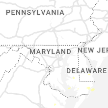
Maryland
| Local Time | Report Details |
|---|---|
| 3:14 PM EDT | Several trees and wires blew down near huntingtow in calvert county MD, 46.4 miles S of Baltimore, MD |
| 3:33 PM EDT | Several trees and wires blew down near huntingtown... including one onto a house. a lightning strike caused a barn fire in the 3300 block of old evans roa in calvert county MD, 47 miles S of Baltimore, MD |
| 3:45 PM EDT | Trees down onto power lines at green point rd. power outages also reported in the are in dorchester county MD, 55.9 miles WNW of Ocean City, MD |
| 4:05 PM EDT | Corrects time...trees down onto power lines at green point rd. power outages also reported in the are in dorchester county MD, 55.9 miles WNW of Ocean City, MD |
| 4:20 PM EDT | Tree downed and partially blocking academy st... md-331. dime to penny sized hail also reported. report via social medi in dorchester county MD, 47.5 miles WNW of Ocean City, MD |
| 4:50 PM EDT | Tree down on north side of the intersection of route 13 and somerset avenue. time estimated from rada in somerset county MD, 33.7 miles WSW of Ocean City, MD |
| 5:36 PM EDT | A wind gust of 51 knots (59 mph) was measured by the weatherflow station at crisfiel in anz543 county MD, 50.1 miles WSW of Ocean City, MD |
Virginia
| Local Time | Report Details |
|---|---|
| 3:35 PM EDT | Large tree branch downed onto a power line on longmeadow blv in chesterfield county VA, 17.5 miles SE of Richmond, VA |
| 3:35 PM EDT | Trees downed and blocking road at walkers mill road... just north of va-40... mckenney hwy. road closed in both directions earlier today. time radar estimate in dinwiddie county VA, 37.7 miles S of Richmond, VA |
| 3:40 PM EDT | Large tree limbs downed along sandy ford road at woodpecker roa in chesterfield county VA, 17.2 miles SSE of Richmond, VA |
| 3:43 PM EDT | Large tree limbs downed and partially blocking road north of lakeview rd/branders bridge intersection. time estimated based on rada in chesterfield county VA, 20.2 miles SE of Richmond, VA |
| 3:55 PM EDT | Large tree limb downed onto a power line at va-648 and south crater r in prince george county VA, 29.5 miles SE of Richmond, VA |
| 4:05 PM EDT | Report of numerous trees downed in the templeton area. numerous power outages also reported in the are in prince george county VA, 30.1 miles SE of Richmond, VA |
| 4:15 PM EDT | Numerous trees reported downed in southern lancaster count in lancaster county VA, 66.8 miles ENE of Richmond, VA |
| 4:16 PM EDT | Tree damage was reported between centreville and reston. a tree blew down near the intersection of va-657 walney road and cabells mill drive. a tree blew down near the in fairfax county VA, 53.6 miles SW of Baltimore, MD |
| 6:09 PM EDT | Tree down near the intersection of cathedral place and west nelson stree in orange county VA, 57.3 miles NNW of Richmond, VA |
| 6:09 PM EDT | Downed tree into wires in the 16000 block of monrovia roa in orange county VA, 55.3 miles NNW of Richmond, VA |
Alabama
| Local Time | Report Details |
|---|---|
| 2:42 PM CDT | Numerous trees and power lines were blown down all around lanett. numerous power outages as a resul in chambers county AL, 24.8 miles NE of Auburn, AL |
| 2:43 PM CDT | Trees were blown down near five point in chambers county AL, 29.4 miles NNE of Auburn, AL |
| 2:43 PM CDT | Several trees were blown down around valle in chambers county AL, 23.8 miles NE of Auburn, AL |
| 4:36 PM CDT | Quarter sized hail reported near Oakman, AL, 34.5 miles WNW of Birmingham, AL, report from mping: quarter (1.00 in.). |
| 4:37 PM CDT | Quarter sized hail reported near Birmingham, AL, 5.1 miles W of Birmingham, AL, quarter size hail falling around ensley. |
| 4:50 PM CDT | Quarter sized hail reported near Tuscaloosa, AL, 49.1 miles WSW of Birmingham, AL |
| 4:52 PM CDT | Numerous trees were blown down in the vicinity of highway 269 and copeland ferry roa in walker county AL, 23.3 miles WNW of Birmingham, AL |
| 4:57 PM CDT | 8-10 trees were blown down on tabor roa in etowah county AL, 66.3 miles NE of Birmingham, AL |
| 4:58 PM CDT | Numerous trees were blown down around birmingport including camp oliver... howtons camp and camp davi in jefferson county AL, 17.9 miles WNW of Birmingham, AL |
| 5:01 PM CDT | A few trees were blown down near the intersection of highway 78 and old jasper highwa in jefferson county AL, 10.7 miles WNW of Birmingham, AL |
| 5:15 PM CDT | Numerous trees were blown down in the pleasant grove are in jefferson county AL, 10 miles WSW of Birmingham, AL |
| 5:16 PM CDT | Numerous trees were blown down and many were blocking roadway in jefferson county AL, 11.9 miles WSW of Birmingham, AL |
| 5:20 PM CDT | Several trees down along highway 82 near springhill roa in barbour county AL, 46.7 miles SSE of Auburn, AL |
| 5:23 PM CDT | *** 2 fatal... 3 inj *** several trees were blown down in birmingham. one tree fell through a home where the injuries occurred. time estimated by rada in jefferson county AL, 2.2 miles W of Birmingham, AL |
| 5:30 PM CDT | Numerous trees were blown down in hoover. several roadways were blocked by the downed tree in jefferson county AL, 9 miles S of Birmingham, AL |
| 5:45 PM CDT | A few trees were blown down around the hoover area. at least one landed on a vehicl in jefferson county AL, 9.7 miles S of Birmingham, AL |
| 5:53 PM CDT | Several trees were blown down in and around pell cit in st. clair county AL, 31.6 miles E of Birmingham, AL |
| 6:15 PM CDT | Trees uprooted and on a house on wilson street in the city of talladeg in talladega county AL, 42.2 miles E of Birmingham, AL |
| 6:19 PM CDT | Quarter sized hail reported near Helena, AL, 18.5 miles SSW of Birmingham, AL |
| 6:25 PM CDT | Multiple trees down in sylacaug in talladega county AL, 40.5 miles SE of Birmingham, AL |
| 6:35 PM CDT | Trees down blocking southbound lane of highway 3 in chilton county AL, 32.5 miles S of Birmingham, AL |
| 6:38 PM CDT | Tree down near greensbor in hale county AL, 52 miles NNW of Camden, AL |
| 6:45 PM CDT | Estimated 60 mph winds a couple miles east of coosa central schoo in coosa county AL, 48.6 miles NW of Auburn, AL |
| 6:50 PM CDT | Multiple trees down blocking county road 55. location approximat in chilton county AL, 42.8 miles SSE of Birmingham, AL |
| 6:51 PM CDT | Multiple trees down around clanto in chilton county AL, 48 miles SSE of Birmingham, AL |
| 7:07 PM CDT | Several trees and power lines were blown down in and around titu in elmore county AL, 49.4 miles W of Auburn, AL |
| 7:07 PM CDT | Several trees and power lines were blown down in and around titu in elmore county AL, 49.4 miles W of Auburn, AL |
| 7:14 PM CDT | Multiple trees down in deatsville and holtsville area in elmore county AL, 51.2 miles W of Auburn, AL |
| 7:14 PM CDT | Trees down from chilton county line to pine level with gust front ahead of storm in autauga county AL, 57.6 miles W of Auburn, AL |
| 7:15 PM CDT | Multiple trees were blown down in and around holtvill in elmore county AL, 48.9 miles W of Auburn, AL |
| 7:18 PM CDT | Multiple trees were blown down in and around deatsvill in elmore county AL, 52.4 miles W of Auburn, AL |
| 7:23 PM CDT | Multiple trees down near the elmore communit in elmore county AL, 48.6 miles W of Auburn, AL |
| 7:30 PM CDT | Multiple trees down in prattvill in autauga county AL, 57.8 miles NE of Camden, AL |
| 7:30 PM CDT | A few trees were blown down in eclectic. one home was on fire due to a probable lightning strik in elmore county AL, 32.6 miles W of Auburn, AL |
| 8:04 PM CDT | Trees and power lines were blown down in several yards near highway 3 in greene county AL, 58.3 miles SE of Starkville, MS |
| 8:16 PM CDT | Multiple trees and power lines were blown down in northern sumter count in sumter county AL, 53.8 miles SSE of Starkville, MS |
| 8:18 PM CDT | Storm damage reported in montgomery county AL, 56.9 miles ENE of Camden, AL |
| 8:30 PM CDT | Numerous trees and power lines down in and around livingsto in sumter county AL, 66.4 miles NW of Camden, AL |
| 8:49 PM CDT | A few trees were blown down around bluffport. one landed on a hom in sumter county AL, 63.6 miles NW of Camden, AL |
| 9:15 PM CDT | Trees were blown down southeast of cub in sumter county AL, 66.8 miles WNW of Camden, AL |
Arkansas
| Local Time | Report Details |
|---|---|
| 2:51 PM CDT | Quarter sized hail reported near Mena, AR, 49 miles NNW of Nashville, AR, trained spotter reported quarter size hail on the south side of mena. |
| 2:54 PM CDT | Trees and large limbs down in and near mena. time estimated from rada in polk county AR, 49 miles NNW of Nashville, AR |
| 3:39 PM CDT | Multiple trees down across the county in montgomery county AR, 32.5 miles NNE of Nashville, AR |
| 3:45 PM CDT | Trees and powerlines down along indian valley road in caddo ga in montgomery county AR, 34.7 miles NNE of Nashville, AR |
| 3:51 PM CDT | At 3:50 pm cdt... a spotter observed wind had blown off an awning and downed several tree limbs at a location 5 miles west of nashville... ar. trees were still blowing in howard county AR, 5.3 miles W of Nashville, AR |
| 3:54 PM CDT | Trees down near diamond park speedway between murfreesboro and nashville. time estimated from rada in pike county AR, 7.9 miles NE of Nashville, AR |
| 4:00 PM CDT | Several trees downed in and near the nashville country club on the west side of nashville. a portion of the roof was also removed from the country club itsel in howard county AR, 2.5 miles WSW of Nashville, AR |
| 4:24 PM CDT | Trees down across southern portions of the county. time estimated from rada in pike county AR, 19.3 miles ENE of Nashville, AR |
| 4:48 PM CDT | Quarter sized hail reported near Thornton, AR, 67.9 miles S of Little Rock, AR, large hail in the town of thornton. time estimated from radar. |
| 5:00 PM CDT | Trees damage in sebastian county AR, 12.1 miles S of Fort Smith, AR |
| 5:48 PM CDT | Quarter sized hail reported near Thornton, AR, 67.9 miles S of Little Rock, AR, large hail in the town of thornton. time estimated from radar. corrected event time. |
| 5:53 PM CDT | Quarter sized hail reported near Dermott, AR, 58.9 miles NNE of Bastrop, LA, dime to quarter sized hail. |
| 5:54 PM CDT | Trees down along highway 8 east of fordyce. time estimated from rada in dallas county AR, 64.5 miles S of Little Rock, AR |
| 6:00 PM CDT | Quarter sized hail reported near Dermott, AR, 58.7 miles NNE of Bastrop, LA, new bout of hail in town. |
Maine
| Local Time | Report Details |
|---|---|
| 3:58 PM EDT | Ox35 reported trees down and a powerline down across from sacopee valley elementary school. time estimated by rada in oxford county ME, 31.9 miles WNW of Portland, ME |
| 4:05 PM EDT | Street blocked... wires dow in oxford county ME, 35.6 miles WNW of Portland, ME |
| 4:12 PM EDT | Multiple trees and wires down. time estimated by rada in cumberland county ME, 20.8 miles NW of Portland, ME |
| 4:17 PM EDT | Ping Pong Ball sized hail reported near Steep Falls, ME, 21.8 miles WNW of Portland, ME, social media photos of hail approximately 1.5 inch. time estimated by radar. |
| 4:21 PM EDT | Multiple trees down and structural damage at a camp in north windham. time estimated by rada in cumberland county ME, 18.6 miles NNW of Portland, ME |
| 4:22 PM EDT | Multiple trees and wires down on marston and basin road in cumberland county ME, 15.8 miles NW of Portland, ME |
| 4:24 PM EDT | Delayed repor in cumberland county ME, 16.3 miles NW of Portland, ME |
| 4:25 PM EDT | Delayed report. tree down across varney mill rd. via facebook with picture. time estimated via rada in cumberland county ME, 14.1 miles NNW of Portland, ME |
| 4:27 PM EDT | Numerous trees and branches down or stripped at center day camp in north windham... outbuilding destroyed by fallen trees. time estimated by rada in cumberland county ME, 15.8 miles NW of Portland, ME |
| 4:30 PM EDT | Multiple trees down on route 2 in york county ME, 31 miles WNW of Portland, ME |
| 4:43 PM EDT | Tree down... debris in roa in york county ME, 24.4 miles WNW of Portland, ME |
| 5:15 PM EDT | Tree down... reported by nws employee on dut in cumberland county ME, 14.4 miles NW of Portland, ME |
| 5:23 PM EDT | Tree down. time estimated by rada in cumberland county ME, 14.9 miles NW of Portland, ME |
| 5:24 PM EDT | Route 24 closed due to trees... lines and poles dow in sagadahoc county ME, 32.4 miles NE of Portland, ME |
| 6:10 PM EDT | Golf Ball sized hail reported near Greenville, ME, 60.6 miles NW of Bangor, ME, photo via social media. |
| 6:22 PM EDT | Half Dollar sized hail reported near Greenville, ME, 58.6 miles NW of Bangor, ME, spotter also reported very strong winds. |
Texas
| Local Time | Report Details |
|---|---|
| 3:36 PM CDT | Measured by a west texas mesone in hale county TX, 20.6 miles NNE of Lubbock, TX |
| 4:09 PM CDT | Lubbock asos in lubbock county TX, 5.7 miles NNE of Lubbock, TX |
| 6:17 PM CDT | First wind gust was 58 mph at 1817cdt. peak wind gust of 71 mph was measured at 1825cdt. last severe wind gust of 65 mph was measured at 1831cd in armstrong county TX, 24.6 miles SE of Amarillo, TX |
Delaware
| Local Time | Report Details |
|---|---|
| 4:40 PM EDT | Report of trees and wires down on a vehicle on dulaney street in seaford... de. time estimated via rada in sussex county DE, 36.7 miles NW of Ocean City, MD |
| 4:45 PM EDT | Numerous downed wires in blades and seaford... de. time estimated via rada in sussex county DE, 35.4 miles NW of Ocean City, MD |
| 4:50 PM EDT | Trees on home at corner of concord pond road and concord road in seaford. time estimated via rada in sussex county DE, 33.3 miles NW of Ocean City, MD |
| 5:04 PM EDT | Report of large trees snapped and dime sized hail on stockley road in milton... de. time estimated via rada in sussex county DE, 25.9 miles NNW of Ocean City, MD |
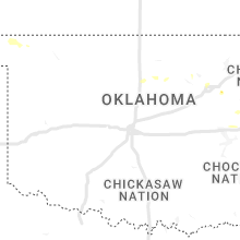
Oklahoma
| Local Time | Report Details |
|---|---|
| 3:52 PM CDT | Power lines and tree limbs down in poteau. report relayed via social medi in le flore county OK, 25.7 miles SSW of Fort Smith, AR |
| 4:32 PM CDT | Large trees down... one on a trailer. minor damage to the trailer. report from public relayed through social media via broadcast media. time is radar estimate in muskogee county OK, 48.7 miles SE of Tulsa, OK |
| 4:50 PM CDT | Trees and power poles down in roland. report relayed via social media. time is radar estimate in sequoyah county OK, 5.6 miles WNW of Fort Smith, AR |
| 5:10 PM CDT | Sallisaw mesonet measured a 61.5 mph wind gus in sequoyah county OK, 21.6 miles W of Fort Smith, AR |
| 5:15 PM CDT | Measured at the sallisaw muni airpor in sequoyah county OK, 21.4 miles WNW of Fort Smith, AR |
| 6:40 PM CDT | Tree limbs down around 61st and 224th in eastern broken arrow. report relayed via social media. time is radar estimate in wagoner county OK, 15.8 miles ESE of Tulsa, OK |
| 6:47 PM CDT | Quarter sized hail reported near Broken Arrow, OK, 17.6 miles ESE of Tulsa, OK, quarter size hail. |
| 7:51 PM CDT | Tulsa asos measured a 70 mph (61kt) wind gus in tulsa county OK, 4.3 miles ESE of Tulsa, OK |
North Dakota
| Local Time | Report Details |
|---|---|
| 4:05 PM CDT | Ping Pong Ball sized hail reported near Bismarck, ND, 6.2 miles NW of Bismarck, ND |
| 4:06 PM CDT | Quarter sized hail reported near Bismarck, ND, 3.8 miles N of Bismarck, ND |
| 4:07 PM CDT | Quarter sized hail reported near Bismarck, ND, 5.4 miles NNW of Bismarck, ND |
| 4:07 PM CDT | Half Dollar sized hail reported near Bismarck, ND, 3.1 miles N of Bismarck, ND |
| 4:13 PM CDT | Tennis Ball sized hail reported near Bismarck, ND, 2.2 miles NE of Bismarck, ND |
| 4:13 PM CDT | Golf Ball sized hail reported near Bismarck, ND, 3.1 miles N of Bismarck, ND |
| 4:30 PM CDT | Tennis Ball sized hail reported near Bismarck, ND, 3.3 miles E of Bismarck, ND |
| 4:35 PM CDT | Quarter sized hail reported near Bismarck, ND, 1.7 miles SE of Bismarck, ND |
| 4:37 PM CDT | Golf Ball sized hail reported near Bismarck, ND, 0.3 miles N of Bismarck, ND, downtown bismarck. this was the second storm which moved through the city. |
| 4:40 PM CDT | Half Dollar sized hail reported near Bismarck, ND, 4.5 miles ESE of Bismarck, ND |
| 4:50 PM CDT | Hen Egg sized hail reported near Moffit, ND, 19.1 miles ESE of Bismarck, ND, social media report with picture. estimated at 2 inches in diameter. |
| 4:58 PM CDT | Quarter sized hail reported near New Salem, ND, 39.1 miles W of Bismarck, ND |
| 5:05 PM CDT | Ping Pong Ball sized hail reported near Almont, ND, 34.7 miles W of Bismarck, ND, quarter size hail to ping pong size hail. hail caused wide spread crop damage. |
| 5:42 PM CDT | Ping Pong Ball sized hail reported near Flasher, ND, 20.7 miles SW of Bismarck, ND, social media reported ping pong sized hail in picture. |
| 5:50 PM CDT | Quarter sized hail reported near Saint Anthony, ND, 14.2 miles SSW of Bismarck, ND, hail was found at least 30 minutes after it fell and had melted some... but was still quarter size. |
| 5:51 PM CDT | Quarter sized hail reported near Saint Anthony, ND, 15.5 miles SSW of Bismarck, ND, measured as a quarter hour and half after hail had fallen. hail caused considerable crop damage. |
| 5:59 PM CDT | Quarter sized hail reported near Wishek, ND, 67.8 miles ESE of Bismarck, ND |
| 6:02 PM CDT | Half Dollar sized hail reported near Wishek, ND, 66.7 miles ESE of Bismarck, ND |
| 6:30 PM CDT | Quarter sized hail reported near Ashley, ND, 48.4 miles NNW of Aberdeen, SD |
| 6:55 PM CDT | Golf Ball sized hail reported near Strasburg, ND, 55.2 miles SSE of Bismarck, ND |
| 7:25 PM CDT | Pea to nickel size hail along with very heavy rain accompanied the severe thunderstorm wind gus in mcintosh county ND, 73.4 miles SE of Bismarck, ND |
| 7:35 PM CDT | Golf Ball sized hail reported near Jamestown, ND, 83.8 miles S of Devils Lake, ND, corrects previous hail report from eldridge. social media report. estimated at golf ball size. |
| 7:55 PM CDT | Golf Ball sized hail reported near Montpelier, ND, 83.5 miles W of Fargo, ND, hail ranged in diameter from half dollar to golf ball size... with most of it being ping pong ball size. the hail had a white core about 3/4 inch in diameter with the r |
| 8:14 PM CDT | Ping Pong Ball sized hail reported near Marion, ND, 75.8 miles WSW of Fargo, ND, hail is coating the ground mostly pea size with some quarters and ping pong size hail. |
| 8:36 PM CDT | Quarter sized hail reported near Wheatland, ND, 29.8 miles W of Fargo, ND, pea to quarter sized hail. |
| 8:49 PM CDT | Quarter sized hail reported near Napoleon, ND, 52.4 miles ESE of Bismarck, ND, hail lasted for about 3 minutes. |
| 8:51 PM CDT | Golf Ball sized hail reported near Napoleon, ND, 52.6 miles ESE of Bismarck, ND, public reported golf ball sized hail. radar estimated time. |
Michigan
| Local Time | Report Details |
|---|---|
| 8:00 PM EDT | Half Dollar sized hail reported near Saint Joseph, MI, 60.7 miles ENE of Chicago, IL |
| 8:03 PM EDT | Delayed report of large trees downed and uprooted. time estimated from rada in berrien county MI, 60.7 miles ENE of Chicago, IL |
| 8:05 PM EDT | Delayed report. large tree limbs down. hail up to dime size in berrien county MI, 61.2 miles ENE of Chicago, IL |
| 8:10 PM EDT | Storm damage reported in berrien county MI, 60.7 miles ENE of Chicago, IL |
| 8:12 PM EDT | A small trailer was overturned and several tree limbs where blown down by gusty thunderstorm wind in kent county MI, 8.6 miles N of Grand Rapids, MI |
| 8:12 PM EDT | Tree branch down with winds estimated at least 50 mph. also at least dime size hai in berrien county MI, 61.2 miles ENE of Chicago, IL |
| 8:20 PM EDT | Numerous reports of trees and power lines down in benton harbor and surrounding areas. some trees onto homes and at least 1 vehicl in berrien county MI, 63 miles ENE of Chicago, IL |
| 8:35 PM EDT | Trees down in vicinity of lawrenc in van buren county MI, 55.7 miles SSW of Grand Rapids, MI |
| 8:55 PM EDT | Reports of several trees downed in the vicinity and report of power pole dow in cass county MI, 74.3 miles SSW of Grand Rapids, MI |
| 8:55 PM EDT | Reports of trees downed and a few power poles dow in cass county MI, 65 miles S of Grand Rapids, MI |
| 8:55 PM EDT | Multiple trees dow in van buren county MI, 56 miles S of Grand Rapids, MI |
| 9:15 PM EDT | Dispatch reports numerous trees and power lines down between three rivers and mendon. time estimated by rada in st. joseph county MI, 66.1 miles NNW of Fort Wayne, IN |
| 9:20 PM EDT | Reports of trees and power lines downe in cass county MI, 71.4 miles NW of Fort Wayne, IN |
| 9:23 PM EDT | Public shared a picture of a 12 inch diameter walnut tree limb down at michigan and summi in st. joseph county MI, 65.5 miles SSE of Grand Rapids, MI |
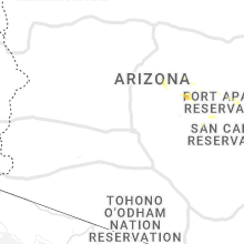
Arizona
| Local Time | Report Details |
|---|---|
| 5:45 PM MST | Large cypress tree fell onto and damaged buildin in gila county AZ, 69.2 miles E of Phoenix, AZ |
| 6:30 PM MST | Mesonet station azt19 i-10 @ mp-372.3 - olg in cochise county AZ, 66.8 miles N of Douglas, AZ |
| 7:10 PM MST | Mesonet station azt19 i-10 @ mp-372.3 - olg in cochise county AZ, 66.8 miles N of Douglas, AZ |
South Dakota
| Local Time | Report Details |
|---|---|
| 7:49 PM CDT | Golf Ball sized hail reported near Eureka, SD, 59.8 miles WNW of Aberdeen, SD, relayed through nws bismarck. time estimated. |
| 7:18 PM MDT | Quarter sized hail reported near Ridgeview, SD, 54.9 miles NNW of Pierre, SD, pea to quarter sized hail. time estimated. |
| 8:03 PM MDT | Half Dollar sized hail reported near Norris, SD, 47 miles NW of Valentine, NE |
| 9:14 PM CDT | Quarter sized hail reported near Mellette, SD, 21.4 miles S of Aberdeen, SD, photo included with report. radar estimated time. |
Nebraska
| Local Time | Report Details |
|---|---|
| 8:14 PM CDT | Storm damage reported in lincoln county NE, 3.8 miles E of North Platte, NE |
| 7:20 PM MDT | Storm damage reported in chase county NE, 62.6 miles SW of North Platte, NE |
| 8:48 PM CDT | Two large branches down on highway. estimated diameter of 4 to 5 inche in lincoln county NE, 25 miles ESE of North Platte, NE |
| 7:52 PM MDT | Public report via phone of estimated 50-60 mph winds with blowing dust which settled once the rain started. heavy rain and no hail was reporte in dundy county NE, 62.9 miles ENE of Yuma, CO |
| 9:37 PM CDT | Asos station kmck mccook airpor in red willow county NE, 60.7 miles NNE of Colby, KS |
| 10:55 PM CDT | Awos station klxn lexington airport. heat burst on back side of decaying convectio in dawson county NE, 57.5 miles ESE of North Platte, NE |
| 11:19 PM CDT | Pws kneelwoo4. associated with heat burst activity on the back side of decaying convectio in dawson county NE, 56.1 miles ESE of North Platte, NE |
Indiana
| Local Time | Report Details |
|---|---|
| 9:46 PM EDT | Report of a tree down blocking the roadway on river roa in elkhart county IN, 58.7 miles NW of Fort Wayne, IN |
New Mexico
| Local Time | Report Details |
|---|---|
| 9:00 PM MDT | Quarter sized hail reported near Loving, NM, 80 miles SSE of Roswell, NM, nickel to quarter sized hail with heavy rain and strong winds in loving. |
Connect with Interactive Hail Maps