

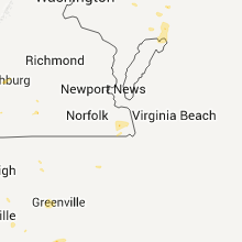
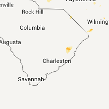
Hail Map for Sunday, July 24, 2011

Number of Impacted Households on 7/24/2011
0
Impacted by 1" or Larger Hail
0
Impacted by 1.75" or Larger Hail
0
Impacted by 2.5" or Larger Hail
Square Miles of Populated Area Impacted on 7/24/2011
0
Impacted by 1" or Larger Hail
0
Impacted by 1.75" or Larger Hail
0
Impacted by 2.5" or Larger Hail


Cities Most Affected by Hail Storms of 7/24/2011
| Hail Size | Demographics of Zip Codes Affected | ||||||
|---|---|---|---|---|---|---|---|
| City | Count | Average | Largest | Pop Density | House Value | Income | Age |
| Glen Ullin, ND | 2 | 2.25 | 2.50 | 1 | $34k | $28.6k | 51.0 |
| Jay Em, WY | 1 | 2.50 | 2.50 | 1 | $60k | $15.0k | 57.5 |
| Montpelier, ND | 1 | 2.00 | 2.00 | 2 | $28k | $30.0k | 43.6 |
| Carrington, ND | 1 | 1.75 | 1.75 | 7 | $60k | $32.5k | 45.7 |
| Goodridge, MN | 1 | 1.75 | 1.75 | 3 | $52k | $29.1k | 41.2 |
| Carpenter, WY | 1 | 1.75 | 1.75 | 4 | $103k | $33.8k | 39.2 |
| New England, ND | 1 | 1.75 | 1.75 | 1 | $37k | $29.1k | 46.8 |
| Larimore, ND | 1 | 1.75 | 1.75 | 4 | $67k | $36.7k | 41.8 |
| Burns, WY | 1 | 1.75 | 1.75 | 5 | $78k | $40.8k | 41.6 |
| Grace City, ND | 1 | 1.75 | 1.75 | 2 | $17k | $38.8k | 36.6 |
Hail and Wind Damage Spotted on 7/24/2011
Filter by Report Type:Hail ReportsWind Reports
States Impacted
Iowa, Illinois, Nebraska, Kansas, Maryland, North Carolina, Delaware, Ohio, Arkansas, Oklahoma, Indiana, North Dakota, New Jersey, Virginia, Colorado, Wyoming, Florida, Missouri, Louisiana, West Virginia, Minnesota, ArizonaIowa
| Local Time | Report Details |
|---|---|
| 12:00 PM UTC | Grain elevator damaged. garage roof partially torn off. large tree branches snapped. corn flattened. time estimate in johnson county IA, 25.3 miles S of Cedar Rapids, IA |
| 3:55 PM UTC | Storm damage reported in linn county IA, 4.6 miles NNE of Cedar Rapids, IA |
| 4:02 PM UTC | Estimated 70 mph winds with some branches dow in linn county IA, 4.4 miles N of Cedar Rapids, IA |
| 4:21 PM UTC | Power is out in mt. verno in linn county IA, 0.5 miles SSE of Cedar Rapids, IA |
| 4:28 PM UTC | Tree limbs down on power lines in cedar county IA, 32.2 miles E of Cedar Rapids, IA |
Illinois
| Local Time | Report Details |
|---|---|
| 12:30 PM UTC | Estimated 60+ wind gust from thunderstorm in la salle county IL, 64.3 miles NE of Peoria, IL |
| 12:36 PM UTC | One 12 inch trunk of a three trunk clump river birch snapped at base and a couple 2 inch maple branches snapped off at highland community college. 1.55 inches of rai in stephenson county IL, 55.4 miles SSW of Madison, WI |
| 6:49 PM UTC | Tree blown down on a house...no injurie in marion county IL, 66.4 miles SSW of Mattoon, IL |
| 6:57 PM UTC | Several trees blown down in town. also... a cable line was blown dow in marion county IL, 58.4 miles E of Saint Louis, MO |
| 8:20 PM UTC | A tree fell on a house in white county IL, 30.7 miles NW of Evansville, IN |
Nebraska
| Local Time | Report Details |
|---|---|
| 1:10 PM UTC | Quarter sized hail reported near Valentine, NE, 15.1 miles SSW of Valentine, NE |
| 10:21 PM UTC | 8 to 10 inch tree branches dow in adams county NE, 33.4 miles S of Grand Island, NE |
| 10:25 PM UTC | 6 inch diamter tree branches snap...power lines down...and street poles snap in town. 1.45 inches of rain in a 30 minute interval as wel in clay county NE, 41 miles SSE of Grand Island, NE |
| 10:30 PM UTC | Heavy rain and visibility less than 200 feet in clay county NE, 39 miles SSE of Grand Island, NE |
| 10:45 PM UTC | Several trees down...on house and a car in town in clay county NE, 36.4 miles SSE of Grand Island, NE |
| 10:45 PM UTC | Tree limb down in sutton but no reports property damage in clay county NE, 33.2 miles SE of Grand Island, NE |
| 10:50 PM UTC | Storm damage reported in nuckolls county NE, 52.6 miles SSE of Grand Island, NE |
| 10:55 PM UTC | Power out in fairfield. power lines down just south of fairfield near deweese and power out in edgar as well. all three communities reporting heavy tree damag in clay county NE, 36.4 miles SSE of Grand Island, NE |
| 11:00 PM UTC | Trees down in town...55 mph estimated wind speed in fillmore county NE, 47.7 miles SE of Grand Island, NE |
| 11:16 PM UTC | Tree branches breakin in thayer county NE, 63.2 miles SSE of Grand Island, NE |
| 11:19 PM UTC | 65 to 70 mph winds. power ou in thayer county NE, 55.7 miles SE of Grand Island, NE |
| 11:30 PM UTC | Power lines down in hebron...belvidere...carlton and deshle in thayer county NE, 65.3 miles SE of Grand Island, NE |
| 11:30 PM UTC | 1 foot diameter tree limbs dow in fillmore county NE, 52.6 miles SE of Grand Island, NE |
| 11:30 PM UTC | Power lines down in hebron...belvidere...carlton and deshle in york county NE, 44.6 miles E of Grand Island, NE |
| 11:46 PM UTC | 60 mph winds measured for the last ten minute in thayer county NE, 73.6 miles SSE of Grand Island, NE |
| 11:50 PM UTC | 2.5 feet in diameter tree branches knocked off tree...estimated 70 mph wind in thayer county NE, 72.1 miles SE of Grand Island, NE |
| 11:56 PM UTC | Wind from mesonet site near crystal springs campground. time estimated. power out in parts of fairbury in jefferson county NE, 73.7 miles NNW of Manhattan, KS |
| 11:56 PM UTC | Lots of limbs and some trees down in fairbury. first severe winds were around 656 to 700 pm with a second blast around 715 p in jefferson county NE, 74.1 miles NNW of Manhattan, KS |
| 12:04 AM UTC | Tree snapped at the base and landed on a house. several 6 to 8 inch tree limbs down in town. water covering the roads in town. wind speeds estimated at 70 mph in thayer county NE, 57.5 miles SE of Grand Island, NE |
| 12:10 AM UTC | Tree down across road. time estimate in jefferson county NE, 68.5 miles NNW of Manhattan, KS |
| 12:15 AM UTC | Semi blown off of highway 8. downed trees/limbs caused power pole/transformer damage...especially across the southern part of the county with power still out in areas a in jefferson county NE, 72.5 miles NNW of Manhattan, KS |
| 12:16 AM UTC | Wind from mesonet site near crystal springs campgroun in jefferson county NE, 73.7 miles NNW of Manhattan, KS |
Kansas
| Local Time | Report Details |
|---|---|
| 2:30 PM UTC | Winds of 45-55 mph resulted in a few power poles being leaned over and tree damage in greenwood county KS, 48.7 miles NW of Chanute, KS |
| 7:40 PM UTC | Two-inch tree limbs were down. the caller also estimated the wind gusts at least at 60 mp in kiowa county KS, 83.5 miles S of Hays, KS |
| 7:55 PM UTC | The reported also reported small limbs were down. this report was from spotternetwork.or in pratt county KS, 77 miles W of Wichita, KS |
| 8:22 PM UTC | Storm damage reported in sedgwick county KS, 5.9 miles SE of Wichita, KS |
| 9:30 PM UTC | A six-inch tree limb was dow in comanche county KS, 48.2 miles N of Woodward, OK |
| 9:37 PM UTC | Fences were blown down. there was damage to a few storage buildings with the damage extent unknow in butler county KS, 30.4 miles ENE of Wichita, KS |
| 10:05 PM UTC | Half Dollar sized hail reported near Abilene, KS, 35.8 miles WSW of Manhattan, KS, 2 other separate reports of quarter size hail adjacent to location. |
| 10:20 PM UTC | The following events were reported 3 miles south of conway. tree damage...one with a 2 foot trunk snapped. a 10 inch limb fell onto fence. power lines downed along fron in mcpherson county KS, 52.7 miles NNW of Wichita, KS |
| 10:20 PM UTC | Numerous power poles were knocked down near the town of conwa in mcpherson county KS, 52.7 miles NNW of Wichita, KS |
| 10:20 PM UTC | The following damage was reported 3 miles south of conway. tree damage...a trunk around 2 feet in diameter snapped and a 10-inch diameter limb fell onto a fence. in add in mcpherson county KS, 52.7 miles NNW of Wichita, KS |
| 10:27 PM UTC | Trees breakin in barton county KS, 49.2 miles ESE of Hays, KS |
| 10:30 PM UTC | Storm damage reported in barton county KS, 45.3 miles SE of Hays, KS |
| 10:42 PM UTC | Brick chimney on house blown over by strong wind in wabaunsee county KS, 29.2 miles SSE of Manhattan, KS |
| 10:44 PM UTC | Law enforcement reported 60 to 70 mph wind gusts at cheyenne bottoms along highway 15 in barton county KS, 49.2 miles SE of Hays, KS |
| 10:47 PM UTC | Shed blown down by winds at least 70 mp in barton county KS, 38.4 miles SE of Hays, KS |
| 10:47 PM UTC | Shed blown down by winds at least 70 mp in barton county KS, 38.4 miles SE of Hays, KS |
| 11:00 PM UTC | Mobile home destroyed with roof damage sustained to a nearby mobile hom in bourbon county KS, 37.2 miles ENE of Chanute, KS |
| 11:00 PM UTC | Emergency manager reports multiple trees of 12 to 18 inch diameter down. also reports 4 to 6 telephone polls snapped on maple road between 165th and 175th roa in bourbon county KS, 37.4 miles ENE of Chanute, KS |
| 11:05 PM UTC | Trees snapped in half in jewell county KS, 78.6 miles S of Grand Island, NE |
| 11:21 PM UTC | Storm damage reported in jewell county KS, 84 miles NE of Hays, KS |
| 11:28 PM UTC | Two trees blown down at residence with power pole damaged as trees topple in geary county KS, 17.7 miles SW of Manhattan, KS |
| 11:30 PM UTC | Large shed was blown 30 feet into a tree in geary county KS, 17.7 miles SW of Manhattan, KS |
| 11:37 PM UTC | Storm damage reported in sumner county KS, 38.9 miles SSW of Wichita, KS |
| 11:50 PM UTC | Quarter sized hail reported near Emporia, KS, 47 miles SSE of Manhattan, KS |
| 12:01 AM UTC | 3 tree limbs measuring 12 inches in diameter were broken from outflow winds. tin from a shed was also blown into a fiel in cloud county KS, 65.1 miles WNW of Manhattan, KS |
| 12:03 AM UTC | Storm damage reported in washington county KS, 69.5 miles NW of Manhattan, KS |
| 12:18 AM UTC | 69 mph wind gust measured by weather station at washington county elementary school in washington county KS, 51.7 miles NNW of Manhattan, KS |
| 12:19 AM UTC | Several power poles downe in lyon county KS, 55.8 miles NNW of Chanute, KS |
| 12:20 AM UTC | Pea size hail also reported at 730 pm cd in pottawatomie county KS, 7.7 miles E of Manhattan, KS |
| 12:30 AM UTC | Storm damage reported in pottawatomie county KS, 16.7 miles NNE of Manhattan, KS |
| 12:32 AM UTC | 50 to 60 mph winds. small tree limbs dow in osborne county KS, 27.7 miles NE of Hays, KS |
| 12:35 AM UTC | Downed limb in neosho county KS, 1 miles SSW of Chanute, KS |
| 12:43 AM UTC | 6 inch tree limbs downed in washington county KS, 51.9 miles NNW of Manhattan, KS |
| 12:45 AM UTC | Storm damage reported in marshall county KS, 35 miles N of Manhattan, KS |
| 1:00 AM UTC | Law enforcement estmated 65 mph wind gusts in wheato in pottawatomie county KS, 25.7 miles NNE of Manhattan, KS |
| 1:00 AM UTC | Shingles blown off a few home in neosho county KS, 19.3 miles SSE of Chanute, KS |
| 1:03 AM UTC | Ranged from 50-60 mp in neosho county KS, 15.5 miles SSE of Chanute, KS |
| 1:07 AM UTC | Emergency management reports several large trees down within the town of wei in cherokee county KS, 45.4 miles SE of Chanute, KS |
| 1:18 AM UTC | Tree damage and some shingles blown off a hous in labette county KS, 23 miles S of Chanute, KS |
| 1:35 AM UTC | Storm damage reported in nemaha county KS, 52.6 miles NNE of Manhattan, KS |
| 1:35 AM UTC | Minor tree damag in labette county KS, 25.6 miles SSE of Chanute, KS |
| 1:35 AM UTC | Minor tree damag in labette county KS, 25.4 miles SSE of Chanute, KS |
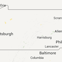
Maryland
| Local Time | Report Details |
|---|---|
| 5:38 PM UTC | Trees uprooted and golf carts knocked over at ocean city golf club in worcester county MD, 7.8 miles SW of Ocean City, MD |
North Carolina
| Local Time | Report Details |
|---|---|
| 6:09 PM UTC | Large tree down on round peak church road in surry county NC, 69.1 miles SW of Roanoke, VA |
| 6:10 PM UTC | Tree down on bryant roa in surry county NC, 69.3 miles SW of Roanoke, VA |
| 6:15 PM UTC | Tree down in the fleetwood area. a building was also struck by lightnin in ashe county NC, 43.9 miles ESE of Bristol, TN |
| 6:26 PM UTC | Tree dow in wilkes county NC, 70.6 miles ESE of Bristol, TN |
| 6:30 PM UTC | 4 trees down behind mcdonalds in beulaville in duplin county NC, 48.3 miles NNE of Wilmington, NC |
| 6:30 PM UTC | Chicken houses damaged and window of home blown in on penny road in duplin county NC, 50.8 miles N of Wilmington, NC |
| 6:32 PM UTC | Staright line wind damge off highway 241 on horse pen ranch lane several trees down some of which fell on home and produced roof damage in duplin county NC, 50.8 miles N of Wilmington, NC |
| 6:50 PM UTC | Tree down in yadkin county NC, 69.5 miles N of Charlotte, NC |
| 6:50 PM UTC | Numerous trees down on valley rd near wildwood d in lee county NC, 38.1 miles WSW of Raleigh, NC |
| 6:52 PM UTC | Multiple trees down near bonlee. some down trees are blocking road in chatham county NC, 44.7 miles WSW of Raleigh, NC |
| 6:52 PM UTC | Three trees down in the in wilkes county NC, 68.2 miles N of Charlotte, NC |
| 7:05 PM UTC | 2 sailboats flipped over at bond lake in cary. water rescues neede in wake county NC, 10.5 miles W of Raleigh, NC |
| 7:15 PM UTC | 20 inch diameter tree down on spring needle ct. lightning also struck a house at that locatio in wake county NC, 10 miles W of Raleigh, NC |
| 7:20 PM UTC | Two trees down near the intersection of high house and maynar in wake county NC, 14.6 miles W of Raleigh, NC |
| 7:25 PM UTC | 15 inch diameter tree split in half with one half blocking the road on calm winds c in wake county NC, 9.4 miles W of Raleigh, NC |
| 7:25 PM UTC | 25 inch diameter and approx 50 ft tall tree uprooted and fell on a house on cole valley dr and did considerable damage. tree then fell on a ca in wake county NC, 9.4 miles W of Raleigh, NC |
| 7:25 PM UTC | Tree down near cole stream ct at maynard r in wake county NC, 9.4 miles W of Raleigh, NC |
| 7:25 PM UTC | Tree down near weatherstone elementar in wake county NC, 9.4 miles W of Raleigh, NC |
| 7:25 PM UTC | 1 tree down on spring bud drive in cary. time estimate in wake county NC, 9.4 miles W of Raleigh, NC |
| 7:25 PM UTC | 8 inch diameter tree snapped off in 2 places approx 15 feet off the ground where the tree forked in wake county NC, 9.4 miles W of Raleigh, NC |
| 7:25 PM UTC | Trained skywarn spotter reports 2 trees down on roebling lane in cary. additional 10 inch hardwood tree snapped in hal in wake county NC, 10 miles W of Raleigh, NC |
| 7:25 PM UTC | Two trees down near the intersection of old apex road and cary parkwa in wake county NC, 10.1 miles W of Raleigh, NC |
| 7:27 PM UTC | New river air station asos wind gust to 59 kt at 327 pm in onslow county NC, 46.5 miles NE of Wilmington, NC |
| 7:30 PM UTC | Four trees blown down in yadkinvill in yadkin county NC, 63.4 miles N of Charlotte, NC |
| 7:37 PM UTC | Tree down on vehicle. powerlines down on road. in front of april showers florist on piney green rd. time estimated from rada in onslow county NC, 49.5 miles NE of Wilmington, NC |
| 7:38 PM UTC | Several trees blown down on cattlemans rd. a tree also down on mountain view rd in the same are in iredell county NC, 51.4 miles N of Charlotte, NC |
| 7:40 PM UTC | Tree limbs down across yard in onslow county NC, 48.6 miles NE of Wilmington, NC |
| 7:42 PM UTC | Tree down on road blocking new bern hwy. time estimated from rada in onslow county NC, 52.2 miles NE of Wilmington, NC |
| 7:44 PM UTC | Quarter sized hail reported near Jacksonville, NC, 50.6 miles NNE of Wilmington, NC, public reported quarter inch hail and trees down near the intersection of indian and gum branch roads. |
| 7:44 PM UTC | Quarter sized hail reported near Jacksonville, NC, 46.8 miles NE of Wilmington, NC, public reported quarter inch hail and trees down near the intersection of indian drive and gum branch road. |
| 7:45 PM UTC | Several tree branches blown dow in wake county NC, 8.8 miles W of Raleigh, NC |
| 7:49 PM UTC | Power pole blown down along south chipley ford rd at the south river baptist churc in iredell county NC, 43.4 miles N of Charlotte, NC |
| 7:51 PM UTC | Tree blocking ingram rd near whites farm r in iredell county NC, 44 miles N of Charlotte, NC |
| 7:55 PM UTC | Trees down on pine valley road in jacksonville in onslow county NC, 47.8 miles NE of Wilmington, NC |
| 7:59 PM UTC | Public reports large tree limbs down on rocky run road near piney gree in onslow county NC, 50.2 miles NE of Wilmington, NC |
| 8:00 PM UTC | Large tree limb fell and broke car windshield. time estimated based on rada in jones county NC, 61.4 miles NE of Wilmington, NC |
| 8:08 PM UTC | Tree down on mallard r in johnston county NC, 27.3 miles SE of Raleigh, NC |
| 8:10 PM UTC | Power line down and smoldering near rt 70 and braswell rd in pine level. fire department respondin in johnston county NC, 31.8 miles SE of Raleigh, NC |
| 8:33 PM UTC | Multiple trees down on bunker hill road and sandy ridge road in guilford county NC, 73.7 miles NE of Charlotte, NC |
| 8:37 PM UTC | Tree down on longwood road at hughes-smith roa in brunswick county NC, 36.1 miles WSW of Wilmington, NC |
| 8:40 PM UTC | 1 tree down in summerfiel in guilford county NC, 73.9 miles S of Roanoke, VA |
| 8:48 PM UTC | Multiple trees and power lines down along highway 501 near the durham and person county line in person county NC, 35.2 miles NNW of Raleigh, NC |
| 8:50 PM UTC | 1 tree down in summerfiel in guilford county NC, 73.9 miles S of Roanoke, VA |
| 9:30 PM UTC | Tree down blocking eakes r in granville county NC, 45.1 miles N of Raleigh, NC |
| 9:30 PM UTC | Power lines down near the intersection of oak hill rd and cornwall r in granville county NC, 47.9 miles N of Raleigh, NC |
| 9:35 PM UTC | Power line down on mountain r in granville county NC, 45.4 miles N of Raleigh, NC |
| 9:35 PM UTC | Shed blown 10 feet in the air and destroyed. several shingles removed from home off of grassy creek roa in granville county NC, 46 miles N of Raleigh, NC |
| 9:40 PM UTC | Numerous large tree branches down along battleboro leggett roa in edgecombe county NC, 59.2 miles ENE of Raleigh, NC |
| 9:40 PM UTC | Five large trees two feet in diameter were split in half near the intersection of dick blackwell road and mountain creek road. a barn and shed sustained damage as well in granville county NC, 45.9 miles N of Raleigh, NC |
| 9:45 PM UTC | Numerous tree limbs down along battleboro leggett rd. time estimate in edgecombe county NC, 59.2 miles ENE of Raleigh, NC |
| 9:45 PM UTC | Tree down on burton chapel roa in caswell county NC, 52.2 miles NW of Raleigh, NC |
| 9:48 PM UTC | Limb down across griers church road in caswell county NC, 50.2 miles NW of Raleigh, NC |
| 9:55 PM UTC | Tree down on route 62 sout in caswell county NC, 54 miles NW of Raleigh, NC |
| 10:09 PM UTC | Multiple trees down south of roxbor in person county NC, 42.8 miles NNW of Raleigh, NC |
Delaware
| Local Time | Report Details |
|---|---|
| 6:15 PM UTC | Tree down between millsboro and laure in sussex county DE, 20.8 miles NNW of Ocean City, MD |
| 6:31 PM UTC | Trees downe in sussex county DE, 18.9 miles NNW of Ocean City, MD |
| 6:59 PM UTC | Tree down on a house in sussex county DE, 29.6 miles NW of Ocean City, MD |
| 6:59 PM UTC | Tree onto hous in sussex county DE, 29.6 miles NW of Ocean City, MD |
Ohio
| Local Time | Report Details |
|---|---|
| 7:20 PM UTC | Boat fl in butler county OH, 28.5 miles N of Cincinnati, OH |
| 7:21 PM UTC | Several large limbs and power lines downed by estimated 60 mph wind gust in montgomery county OH, 41.7 miles NNE of Cincinnati, OH |
| 7:25 PM UTC | Trees down from high winds in montgomery county OH, 40.8 miles NNE of Cincinnati, OH |
| 7:29 PM UTC | Large limbs down near benner rd and byers r in montgomery county OH, 38.1 miles NNE of Cincinnati, OH |
| 10:15 PM UTC | Trees down along brown r in franklin county OH, 4.1 miles SSW of Columbus, OH |
Arkansas
| Local Time | Report Details |
|---|---|
| 7:30 PM UTC | Downed trees and broken windows along spanker creek road on northeast side of bentonville. time estimated based on rada in benton county AR, 72.2 miles NNE of Fort Smith, AR |
| 8:15 PM UTC | Several large trees and limbs down on u.s. highway 71 southwest of men in polk county AR, 48 miles NNW of Nashville, AR |
| 9:00 PM UTC | A few large trees reported down along hwy 2 in ouachita county AR, 53.4 miles ESE of Nashville, AR |
| 9:22 PM UTC | Reported trees down in clay county AR, 73.3 miles SSW of Cape Girardeau, MO |
| 11:53 PM UTC | Local coordinator reported one commercial business had roof damage due to heavy amount of rain in piggott. multiple power lines down causing 90 percent of town without in clay county AR, 73.3 miles SSW of Cape Girardeau, MO |
Oklahoma
| Local Time | Report Details |
|---|---|
| 7:38 PM UTC | Tree damage and estimated 50 mph winds. relayed by kot in tulsa county OK, 13.1 miles S of Tulsa, OK |
| 8:00 PM UTC | Large limb downe in tulsa county OK, 15.8 miles SSE of Tulsa, OK |
| 8:53 PM UTC | Multiple homes experiencing minor roof damage. several large trees downed on to a few home in mayes county OK, 37.6 miles ENE of Tulsa, OK |
| 8:53 PM UTC | Four barns mainly of wood frame and tin collapsed. siding and shingles torn from six homes. glass broken in two vehicles. four privacy fences downed and trailer overtur in mayes county OK, 35.5 miles ENE of Tulsa, OK |
| 9:15 PM UTC | Storm damage reported in rogers county OK, 28.3 miles E of Tulsa, OK |
| 9:21 PM UTC | *** 1 inj *** horse and buggy carrying one passenger flipped over by wind. passenger was a woman who was trapped and injured during the inciden in mayes county OK, 35.4 miles E of Tulsa, OK |
| 9:21 PM UTC | Three barns of wood frame and tin damaged one collapsed two had roofing torn off. this is added information to previous lsr concerning damages ssw of choutea in mayes county OK, 35.4 miles E of Tulsa, OK |
| 9:55 PM UTC | Via ok mesonet in woodward county OK, 25.3 miles NE of Woodward, OK |
| 10:31 PM UTC | Storm damage reported in major county OK, 32.3 miles E of Woodward, OK |
| 10:35 PM UTC | Estimated 60-70 mph gust in grant county OK, 76.8 miles ENE of Woodward, OK |
| 11:17 PM UTC | Power lines down...outbuildings blown ove in pittsburg county OK, 42.7 miles NNE of Atoka, OK |
| 12:35 AM UTC | Storm damage reported in pittsburg county OK, 33.5 miles N of Atoka, OK |
Indiana
| Local Time | Report Details |
|---|---|
| 7:45 PM UTC | Multiple utility poles and trees down with minor structural damage. damage estimated to have occurred between 330 and 400 p in randolph county IN, 61.1 miles S of Fort Wayne, IN |
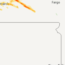
North Dakota
| Local Time | Report Details |
|---|---|
| 7:55 PM UTC | Golf Ball sized hail reported near New England, ND, 106.2 miles W of Bismarck, ND, majority of hail was nickels...but hail was up to the size of a golf balls. hail lasted about 5 minutes. |
| 7:56 PM UTC | Quarter sized hail reported near New England, ND, 101.1 miles W of Bismarck, ND, dime to quarter size hail |
| 7:56 PM UTC | Storm damage reported in hettinger county ND, 101.1 miles W of Bismarck, ND |
| 8:10 PM UTC | Tennis Ball sized hail reported near Glen Ullin, ND, 53.5 miles W of Bismarck, ND, late report. |
| 8:22 PM UTC | Quarter sized hail reported near Glen Ullin, ND, 47.1 miles W of Bismarck, ND |
| 8:29 PM UTC | Hen Egg sized hail reported near Glen Ullin, ND, 44.2 miles W of Bismarck, ND, relayed by law enforcement...golfball to hen egg sized hail reported by public near mile marker 115 on interstate 94. |
| 8:33 PM UTC | Very heavy rain with visibility 50 feet. ndhp report. near mile marker 115 on interstate 94. hail size has decreased to about dime siz in morton county ND, 47.9 miles W of Bismarck, ND |
| 8:45 PM UTC | Half Dollar sized hail reported near Pettibone, ND, 60.1 miles ENE of Bismarck, ND, quarter to half dollar sized hail... 0.5 to 1 inch deep... |
| 8:50 PM UTC | Quarter sized hail reported near New Salem, ND, 34.3 miles WNW of Bismarck, ND, hail up to the size of quarters... heavy rain... winds up to 35 mph... |
| 9:05 PM UTC | Quarter sized hail reported near Sterling, ND, 27.8 miles ENE of Bismarck, ND, hail up to the size of quarters... lasted for about 5 minutes... winds estimated at 40 mph. |
| 9:12 PM UTC | Dime size hail. lasted 5 minutes. they have not had time to assess if there is damag in morton county ND, 25.3 miles W of Bismarck, ND |
| 9:57 PM UTC | Quarter sized hail reported near Tappen, ND, 52.7 miles E of Bismarck, ND, hail lasted about 2 minutes. |
| 10:10 PM UTC | Quarter sized hail reported near Larimore, ND, 58.6 miles ESE of Devils Lake, ND |
| 10:15 PM UTC | Golf Ball sized hail reported near Larimore, ND, 58.6 miles ESE of Devils Lake, ND |
| 10:20 PM UTC | Hen Egg sized hail reported near Montpelier, ND, 77.4 miles N of Aberdeen, SD |
| 10:25 PM UTC | Half Dollar sized hail reported near Arvilla, ND, 64.8 miles ESE of Devils Lake, ND |
| 10:30 PM UTC | Quarter sized hail reported near Tuttle, ND, 47 miles NE of Bismarck, ND |
| 11:05 PM UTC | Golf Ball sized hail reported near Carrington, ND, 46.4 miles SSW of Devils Lake, ND, hail lasted 8 minutes. no significant wind. |
| 11:33 PM UTC | Golf Ball sized hail reported near Grace City, ND, 39.6 miles S of Devils Lake, ND, lasted 5 minutes. very little wind. brief but very heavy rain. |
New Jersey
| Local Time | Report Details |
|---|---|
| 7:59 PM UTC | Trees down in burlington county NJ, 66.6 miles SW of Brooklyn, NY |
| 8:15 PM UTC | Numerous trees down in burlington county NJ, 76.5 miles SSW of Brooklyn, NY |
| 9:00 PM UTC | Also trees and wires down in cape may county NJ, 69.6 miles NNE of Ocean City, MD |
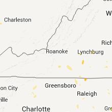
Virginia
| Local Time | Report Details |
|---|---|
| 8:04 PM UTC | Tree blown down by thunderstorm wind gus in augusta county VA, 72.7 miles NE of Roanoke, VA |
| 8:20 PM UTC | Tree down on powerline on durrett town rd in nelson county VA, 71.5 miles WNW of Richmond, VA |
| 8:40 PM UTC | Trees down on goose dam rd in franklin county VA, 25.5 miles SSE of Roanoke, VA |
| 8:48 PM UTC | Trees down on mcneil mill rd in franklin county VA, 26.5 miles SSE of Roanoke, VA |
| 8:50 PM UTC | 2 trees and several branches down on sontag rd in franklin county VA, 27.8 miles SSE of Roanoke, VA |
| 9:05 PM UTC | Tress down on toshes rd in pittsylvania county VA, 33.3 miles SE of Roanoke, VA |
| 9:06 PM UTC | Trees and power lines down on climax rd in pittsylvania county VA, 38.1 miles SE of Roanoke, VA |
| 9:08 PM UTC | Tree down on castleton roa in wythe county VA, 56.8 miles WSW of Roanoke, VA |
| 9:15 PM UTC | Trees down on halifax rd in pittsylvania county VA, 43.5 miles SE of Roanoke, VA |
| 9:30 PM UTC | Trees down in java in pittsylvania county VA, 49.7 miles SE of Roanoke, VA |
| 10:10 PM UTC | Trees down on country club roa in appomattox county VA, 59.1 miles E of Roanoke, VA |
| 10:16 PM UTC | Large trees down on county club road in appomattox county VA, 59.1 miles E of Roanoke, VA |
| 10:18 PM UTC | Trees down on purdum mill road in appomattox county VA, 60.3 miles E of Roanoke, VA |
| 10:20 PM UTC | Many trees reported down in the phenix are in charlotte county VA, 68 miles WSW of Richmond, VA |
| 10:24 PM UTC | Many trees down in the red oak and wylliesburg are in charlotte county VA, 70.7 miles N of Raleigh, NC |
| 10:24 PM UTC | Trees down on red house road in appomattox county VA, 61.3 miles E of Roanoke, VA |
| 10:24 PM UTC | Several trees down on promise land road in appomattox county VA, 60.1 miles E of Roanoke, VA |
| 12:00 AM UTC | One foot diameter tree down in dinwiddie county VA, 27.2 miles S of Richmond, VA |
| 12:12 AM UTC | Tree dow in sussex county VA, 45.2 miles SSE of Richmond, VA |
Colorado
| Local Time | Report Details |
|---|---|
| 9:25 PM UTC | Quarter sized hail reported near Elizabeth, CO, 32 miles SE of Denver, CO |
| 1:30 AM UTC | Quarter sized hail reported near Nunn, CO, 59.3 miles SE of Laramie, WY |
| 1:39 AM UTC | Quarter sized hail reported near Pierce, CO, 60.7 miles SE of Laramie, WY |
| 1:45 AM UTC | Ping Pong Ball sized hail reported near Fort Collins, CO, 56 miles SE of Laramie, WY, 50 mph wind gust |
| 2:35 AM UTC | Tree branches down wcr 5 and co14. three inches standing rain and hail on the road in larimer county CO, 54.4 miles SSE of Laramie, WY |
| 3:35 AM UTC | Storm damage reported in weld county CO, 50.7 miles NNE of Denver, CO |
Wyoming
| Local Time | Report Details |
|---|---|
| 9:33 PM UTC | Golf Ball sized hail reported near Burns, WY, 48.7 miles SW of Scottsbluff, NE, near county roads 147 and 227. |
| 9:40 PM UTC | Quarter sized hail reported near Burns, WY, 49.1 miles SW of Scottsbluff, NE |
| 9:51 PM UTC | Pea to marbel size hai in laramie county WY, 43.8 miles SW of Scottsbluff, NE |
| 10:20 PM UTC | Quarter sized hail reported near Burns, WY, 58.8 miles SW of Scottsbluff, NE |
| 11:09 PM UTC | Golf Ball sized hail reported near Carpenter, WY, 66.5 miles SSW of Scottsbluff, NE |
| 11:46 PM UTC | Quarter sized hail reported near Cheyenne, WY, 41.3 miles ESE of Laramie, WY |
| 11:52 PM UTC | Quarter sized hail reported near Cheyenne, WY, 39.4 miles ESE of Laramie, WY |
| 11:53 PM UTC | Quarter sized hail reported near Cheyenne, WY, 41.3 miles ESE of Laramie, WY |
| 11:55 PM UTC | Half Dollar sized hail reported near Cheyenne, WY, 41.1 miles ESE of Laramie, WY, consistent quarter sized to half dollar sized hail between 550p and 555p at frontier park. |
| 5:59 PM MDT | Ping Pong Ball sized hail reported near Cheyenne, WY, 42 miles ESE of Laramie, WY, at 27th street and ames. |
| 6:11 PM MDT | Ping Pong Ball sized hail reported near Fe Warren Afb, WY, 40.1 miles ESE of Laramie, WY, at warren air force base. |
| 1:28 AM UTC | Tennis Ball sized hail reported near Jay Em, WY, 56.7 miles NW of Scottsbluff, NE |
Florida
| Local Time | Report Details |
|---|---|
| 9:42 PM UTC | The sheriffs office received a report of trees blown down on the 17000 block of state road 12 in alachua county FL, 56.8 miles SW of Jacksonville, FL |
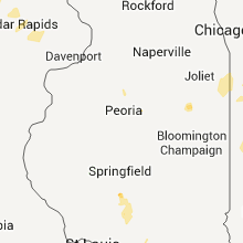
Missouri
| Local Time | Report Details |
|---|---|
| 9:50 PM UTC | Reported power poles and power lines dow in dunklin county MO, 75.2 miles N of Memphis, TN |
| 9:50 PM UTC | Reported power in dunklin county MO, 75.2 miles N of Memphis, TN |
| 10:07 PM UTC | Trees reported down or damaged in many areas of roll in phelps county MO, 25.1 miles NNW of Salem, MO |
| 10:13 PM UTC | Quarter sized hail reported near Rolla, MO, 25.1 miles NNW of Salem, MO |
| 10:15 PM UTC | A few power poles downed. relayed via maries county emergency manage in phelps county MO, 25.1 miles NNW of Salem, MO |
| 10:15 PM UTC | Power lines down near intersection of highway e and highway a. relayed from maries county emergency manage in phelps county MO, 31.2 miles NNW of Salem, MO |
| 10:30 PM UTC | Several trees and power lines down. shingle damage to roofs and windows broken due to downed trees. a few sheds blown over. concentration of damage is near the intersec in phelps county MO, 24 miles NNW of Salem, MO |
| 11:35 PM UTC | Barn destroyed and a few trees dow in polk county MO, 18.3 miles N of Springfield, MO |
| 12:28 AM UTC | Vinyl siding ripped from house. home weather equipment measured a 68 mph wind gus in greene county MO, 0.6 miles S of Springfield, MO |
| 12:31 AM UTC | 70 mph wind gust measured at springfield asos in greene county MO, 5.8 miles WNW of Springfield, MO |
| 12:52 AM UTC | Fire department estimated wind speeds up to 60 mp in greene county MO, 7.5 miles SW of Springfield, MO |
| 12:52 AM UTC | Nws personnel estimates a wind gust of at least 60 mph. shingles were blown off a roof with damage to one tre in greene county MO, 7.5 miles SW of Springfield, MO |
| 1:04 AM UTC | Numerous snapped large tree limbs observe in christian county MO, 9.3 miles SSW of Springfield, MO |
| 1:30 AM UTC | Garage door reported bowed in due to high wind in barton county MO, 58.8 miles E of Chanute, KS |
| 1:35 AM UTC | Storm damage reported in barton county MO, 60.8 miles WNW of Springfield, MO |
| 1:35 AM UTC | Minor roof damage reporte in barton county MO, 56.9 miles ESE of Chanute, KS |
| 2:25 AM UTC | Power pole down and two trees downed on the western side of sarcoxi in jasper county MO, 49.4 miles W of Springfield, MO |
| 2:37 AM UTC | Subway worker in sarcoxie observed at least 60 to 70 mph wind gust in jasper county MO, 46.7 miles WSW of Springfield, MO |
| 2:40 AM UTC | 6 to 8 inch tree limbs down. cwip repor in jasper county MO, 47.3 miles WSW of Springfield, MO |
| 3:00 AM UTC | Three trees down across highway d and racoon road. time of event estimate in newton county MO, 59.9 miles WSW of Springfield, MO |
Louisiana
| Local Time | Report Details |
|---|---|
| 10:10 PM UTC | Trees reported down across the paris in claiborne county LA, 44.3 miles ENE of Shreveport, LA |
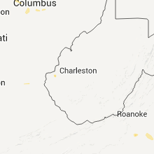
West Virginia
| Local Time | Report Details |
|---|---|
| 11:20 PM UTC | Spencer adkins reports a strand of trees down and a flag pole snapped of in cabell county WV, 44.2 miles W of Charleston, WV |
Minnesota
| Local Time | Report Details |
|---|---|
| 12:15 AM UTC | Tin blown off of roof. 8 to 10 inch diameter tree branches dow in marshall county MN, 43.3 miles S of Roseau, MN |
| 12:15 AM UTC | Golf Ball sized hail reported near Goodridge, MN, 43.3 miles S of Roseau, MN |
| 1:25 AM UTC | Numerous mature trees down in and around fisher. several fences damaged. hail to nickel siz in polk county MN, 63.8 miles N of Fargo, ND |
| 1:35 AM UTC | Large tree branches down throughout the city. door blown in at hugos. estimated winds 50 to 70 mp in polk county MN, 62.3 miles N of Fargo, ND |
| 2:12 AM UTC | Half a pine tree down at st johns cemetary...other large branches down blocking roa in polk county MN, 49.8 miles WNW of Bemidji, MN |
| 2:15 AM UTC | 3 inch diameter tree branch dow in polk county MN, 48.6 miles WNW of Bemidji, MN |
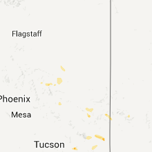
Arizona
| Local Time | Report Details |
|---|---|
| 5:45 PM MST | Power lines dow in gila county AZ, 72.5 miles SW of Show Low, AZ |
Connect with Interactive Hail Maps