

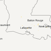
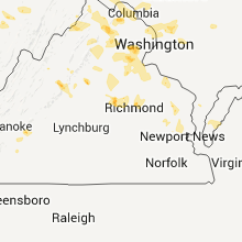
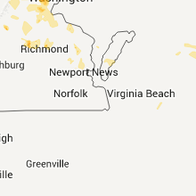
Hail Map for Sunday, July 3, 2011

Number of Impacted Households on 7/3/2011
0
Impacted by 1" or Larger Hail
0
Impacted by 1.75" or Larger Hail
0
Impacted by 2.5" or Larger Hail
Square Miles of Populated Area Impacted on 7/3/2011
0
Impacted by 1" or Larger Hail
0
Impacted by 1.75" or Larger Hail
0
Impacted by 2.5" or Larger Hail


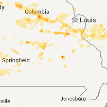


Cities Most Affected by Hail Storms of 7/3/2011
| Hail Size | Demographics of Zip Codes Affected | ||||||
|---|---|---|---|---|---|---|---|
| City | Count | Average | Largest | Pop Density | House Value | Income | Age |
| Owensville, MO | 1 | 1.75 | 1.75 | 32 | $74k | $34.4k | 43.0 |
| Camdenton, MO | 1 | 1.75 | 1.75 | 121 | $105k | $32.0k | 45.1 |
| Springfield, MO | 1 | 1.75 | 1.75 | 4768 | $50k | $15.5k | 26.2 |
| Columbia, MO | 1 | 1.75 | 1.75 | 402 | $99k | $27.0k | 22.7 |
Hail and Wind Damage Spotted on 7/3/2011
Filter by Report Type:Hail ReportsWind Reports
States Impacted
Indiana, Missouri, Illinois, Arkansas, Louisiana, Pennsylvania, Kansas, West Virginia, Ohio, North Carolina, Virginia, South Carolina, Alabama, Mississippi, Texas, Wyoming, New Jersey, Georgia, Maryland, District of Columbia, Montana, New Mexico, Nevada, ArizonaIndiana
| Local Time | Report Details |
|---|---|
| 5:44 PM UTC | Quarter sized hail reported near Jasper, IN, 44.3 miles NE of Evansville, IN |
Missouri
| Local Time | Report Details |
|---|---|
| 6:23 PM UTC | Half Dollar sized hail reported near Owensville, MO, 49.2 miles N of Salem, MO, wind gusts around 40 mph |
| 6:34 PM UTC | Ping Pong Ball sized hail reported near Owensville, MO, 49.2 miles N of Salem, MO |
| 6:35 PM UTC | Golf Ball sized hail reported near Owensville, MO, 49.2 miles N of Salem, MO |
| 6:55 PM UTC | Quarter sized hail reported near Marthasville, MO, 42.8 miles W of Saint Louis, MO, winds gusts up to 45 mph |
| 7:05 PM UTC | Golf Ball sized hail reported near Columbia, MO, 0.3 miles SE of Columbia, MO |
| 7:09 PM UTC | Storm damage reported in franklin county MO, 34.6 miles WSW of Saint Louis, MO |
| 7:10 PM UTC | 12 inch branch blocking new haven roa in boone county MO, 4.3 miles ESE of Columbia, MO |
| 7:19 PM UTC | Quarter sized hail reported near Park Hills, MO, 56.4 miles SSW of Saint Louis, MO |
| 7:20 PM UTC | Quarter sized hail reported near Park Hills, MO, 56.6 miles SSW of Saint Louis, MO, hail ranging from dime sized to quarter sized |
| 7:20 PM UTC | Large tree blocking missouri highway ww at blackthor in boone county MO, 3.5 miles E of Columbia, MO |
| 7:26 PM UTC | Numerous tree limbs down 2 to 3 inches in diameter in st. francois county MO, 55.1 miles SSW of Saint Louis, MO |
| 7:33 PM UTC | Quarter sized hail reported near New Haven, MO, 55.4 miles W of Saint Louis, MO |
| 7:46 PM UTC | Quarter sized hail reported near Strafford, MO, 8.6 miles ENE of Springfield, MO |
| 7:49 PM UTC | Storm damage reported in st. louis county MO, 15.6 miles WSW of Saint Louis, MO |
| 7:57 PM UTC | Storm damage reported in callaway county MO, 34.2 miles E of Columbia, MO |
| 8:00 PM UTC | 6 flags sign near interstate 44 damaged by high winds. numerous 4-8 inch diameter limbs also snapped off in st. louis county MO, 27.5 miles WSW of Saint Louis, MO |
| 8:00 PM UTC | Quarter sized hail reported near Camdenton, MO, 61.2 miles NNE of Springfield, MO |
| 8:00 PM UTC | Golf Ball sized hail reported near Camdenton, MO, 63 miles NNE of Springfield, MO |
| 8:02 PM UTC | Quarter sized hail reported near Camdenton, MO, 65.4 miles NNE of Springfield, MO |
| 8:13 PM UTC | Quarter sized hail reported near St Louis, MO, 11 miles SW of Saint Louis, MO |
| 8:29 PM UTC | Half Dollar sized hail reported near Springfield, MO, 0.8 miles SW of Springfield, MO |
| 8:31 PM UTC | Golf Ball sized hail reported near Springfield, MO, 0.6 miles S of Springfield, MO, spotter reported golf ball sized hail at walnut and kansas expressway. |
| 8:40 PM UTC | Storm damage reported in warren county MO, 52.5 miles WNW of Saint Louis, MO |
| 8:43 PM UTC | Portion of roof ripped off at commercial real estate building near intersection of highway 47 and veterans memorial parkwa in warren county MO, 52.5 miles WNW of Saint Louis, MO |
| 8:43 PM UTC | Roof ripped off at commercial real estate building near intersection of highway 47 and veterans memorial parkwa in warren county MO, 52.5 miles WNW of Saint Louis, MO |
| 9:00 PM UTC | Roof damage caused by tree limb of unknown size. time estimate in ste. genevieve county MO, 46.1 miles S of Saint Louis, MO |
| 9:03 PM UTC | 2 inch diameter tree limb down....trees of unknown size also dow in warren county MO, 52.5 miles WNW of Saint Louis, MO |
| 9:03 PM UTC | 16 inch diameter limb blown down from a healthy tree. time estimated. approximately one half mile north of interstate 70 in warren county MO, 52.5 miles WNW of Saint Louis, MO |
| 9:04 PM UTC | Two large trees down over bell road greater than 12 inches in diameter. also... power poles taken down on bell roa in warren county MO, 46.5 miles WNW of Saint Louis, MO |
| 9:07 PM UTC | Storm damage reported in st. charles county MO, 40.9 miles WNW of Saint Louis, MO |
| 9:15 PM UTC | Numerous trees and branches down in town...time estimated from radar in lincoln county MO, 48.6 miles WNW of Saint Louis, MO |
| 9:16 PM UTC | 12 inch diameter tree uprooted and power lines down across town in lincoln county MO, 48.6 miles WNW of Saint Louis, MO |
| 9:28 PM UTC | Spotter located at t.r. hughes park in st. charles county MO, 29.5 miles WNW of Saint Louis, MO |
| 10:25 PM UTC | Quarter sized hail reported near Plato, MO, 33.8 miles W of Salem, MO |
| 11:02 PM UTC | Several large trees down...along with shingle damage to a roof. near the intersection of hwy t and ff. time estimated from rada in vernon county MO, 46.7 miles E of Chanute, KS |
| 11:13 PM UTC | Emergency management reports multiple large trees uprooted in libera in barton county MO, 51.8 miles E of Chanute, KS |
| 11:17 PM UTC | Power lines reported down on cedar street due to tree limbs broken off during high wind in vernon county MO, 61.3 miles E of Chanute, KS |
| 11:20 PM UTC | Tree reported down across main stree in vernon county MO, 61.3 miles E of Chanute, KS |
| 11:20 PM UTC | Steel highway sign bolts sheared by high winds and sign was blown over onto roa in barton county MO, 62.8 miles WNW of Springfield, MO |
| 11:22 PM UTC | Large metal sign blown over on highway 71 at county road d in vernon county MO, 63.7 miles E of Chanute, KS |
| 12:50 AM UTC | Reports of power lines and poles down along with large trees within monet in barry county MO, 40.5 miles WSW of Springfield, MO |
| 12:50 AM UTC | Report of large trees down about 1 mile south of highway 60 near highway 3 in barry county MO, 40.9 miles WSW of Springfield, MO |
| 2:34 AM UTC | Tree was reported down across highway 76 at beaver creek near the highway 76 and highway t intersectio in douglas county MO, 33.3 miles SE of Springfield, MO |
| 2:50 AM UTC | Tree was reported down across highway 76 at beaver creek near the highway 76 and highway t intersectio in douglas county MO, 33.3 miles SE of Springfield, MO |
Illinois
| Local Time | Report Details |
|---|---|
| 6:40 PM UTC | Half Dollar sized hail reported near New Athens, IL, 27.4 miles SE of Saint Louis, MO |
| 6:57 PM UTC | Quarter sized hail reported near Dix, IL, 69.5 miles E of Saint Louis, MO |
| 7:35 PM UTC | Storm damage reported in wayne county IL, 61.5 miles WNW of Evansville, IN |
| 8:30 PM UTC | Large tree down blocking highway 157 both directioons near old st. louis road...also a tree on trailer near thunderbird lan in st. clair county IL, 7.5 miles SE of Saint Louis, MO |
| 8:45 PM UTC | Ping Pong Ball sized hail reported near Carlyle, IL, 44.9 miles E of Saint Louis, MO |
| 8:51 PM UTC | Quarter sized hail reported near Beckemeyer, IL, 41.7 miles E of Saint Louis, MO |
| 9:16 PM UTC | Numerous tree limbs down ranging from 2 to 6 inches in diameter. time estimate in madison county IL, 24.8 miles ENE of Saint Louis, MO |
Arkansas
| Local Time | Report Details |
|---|---|
| 7:20 PM UTC | Several trees and powerlines down through the city of crosset in ashley county AR, 24.4 miles N of Bastrop, LA |
| 10:22 PM UTC | Winds damaged the front of the deliverance temple church of god in christ. bricks were reported to have come through the ceiling. there were no injuries reporte in miller county AR, 35.7 miles SSW of Nashville, AR |
Louisiana
| Local Time | Report Details |
|---|---|
| 7:22 PM UTC | St. tammany parish emergency manager reported power lines down...tree branches down and some roofing material off of outbuildings along jack fork road outside of folsom in st. tammany county LA, 44.8 miles N of New Orleans, LA |
| 8:55 PM UTC | Broadcast media reported a tree downed and blocking the road at beechwood drive and byron avenu in east baton rouge county LA, 55.3 miles ENE of Lafayette, LA |
| 9:10 PM UTC | Fireworks stand blown down and 3 storage sheds rolled with two destroye in iberia county LA, 18.4 miles SSE of Lafayette, LA |
Pennsylvania
| Local Time | Report Details |
|---|---|
| 7:30 PM UTC | Trees down in ronco and masontown in fayette county PA, 39.4 miles S of Pittsburgh, PA |
| 7:33 PM UTC | Numerous trees down in carmichaels... dillner... and nemacoli in greene county PA, 37.2 miles S of Pittsburgh, PA |
| 7:38 PM UTC | Powerlines down in uniontown. poor drainage flooding in uniontown and union townshi in fayette county PA, 39.9 miles SSE of Pittsburgh, PA |
| 8:08 PM UTC | Tree down in northampton county PA, 46.7 miles SSE of Scranton, PA |
| 8:25 PM UTC | Tree down across road in northampton county PA, 55.9 miles SSE of Scranton, PA |
| 8:25 PM UTC | Tree into structure in northampton county PA, 52.3 miles SSE of Scranton, PA |
| 8:25 PM UTC | Poles wires down in northampton county PA, 49.3 miles SSE of Scranton, PA |
| 8:38 PM UTC | Tree acroos road in northampton county PA, 58.4 miles SSE of Scranton, PA |
| 8:38 PM UTC | Tree across road in northampton county PA, 58.4 miles SSE of Scranton, PA |
| 9:05 PM UTC | Power poles and wires down in bucks county PA, 71.9 miles WSW of Brooklyn, NY |
Kansas
| Local Time | Report Details |
|---|---|
| 7:41 PM UTC | The winds were estimated between 60 and 70 mp in pratt county KS, 76.5 miles W of Wichita, KS |
| 7:41 PM UTC | Quarter sized hail reported near Iuka, KS, 76.5 miles W of Wichita, KS |
| 7:42 PM UTC | Thunderstorm wind gusts blew over a large pear tre in pratt county KS, 76.5 miles W of Wichita, KS |
| 7:57 PM UTC | *** 2 inj *** emergency manager reports fireworks tent blown over and caused two minor injurie in sedgwick county KS, 12.4 miles W of Wichita, KS |
| 7:58 PM UTC | Twelve inch diameter limbs broken off trees and a chain link fence blown dow in pratt county KS, 76.5 miles W of Wichita, KS |
| 8:09 PM UTC | Law enforcement estimates 50 to 60 mph winds on west side of cheney lak in reno county KS, 25.8 miles W of Wichita, KS |
| 8:15 PM UTC | Law enforcement estimates 60 mph winds with pea to marble sized hai in woodson county KS, 28.5 miles WNW of Chanute, KS |
| 8:16 PM UTC | The pole of a martin bird house was snapped off. the electricity has also been knocked ou in pratt county KS, 78.7 miles W of Wichita, KS |
| 8:22 PM UTC | An irrigation system was blown over at 70th avenue and 20th stree in pratt county KS, 70.4 miles W of Wichita, KS |
| 8:25 PM UTC | Off duty nws employee reports isolated bursts of 60 mph wind in sedgwick county KS, 6.8 miles W of Wichita, KS |
| 8:26 PM UTC | Storm damage reported in pratt county KS, 77 miles W of Wichita, KS |
| 8:35 PM UTC | Storm damage reported in pratt county KS, 77 miles W of Wichita, KS |
| 8:52 PM UTC | Kwch storm chaser estimates 50 to 60 mph winds at 135th and centra in sedgwick county KS, 6.8 miles W of Wichita, KS |
| 9:00 PM UTC | Storm damage reported in sedgwick county KS, 7.9 miles W of Wichita, KS |
| 9:00 PM UTC | Off duty nws employee reports 50 to 60 mph wind in sedgwick county KS, 8.2 miles WNW of Wichita, KS |
| 9:13 PM UTC | Storm damage reported in butler county KS, 13.3 miles ENE of Wichita, KS |
| 9:18 PM UTC | Storm damage reported in butler county KS, 24.5 miles NE of Wichita, KS |
| 9:18 PM UTC | Emergency manager reports 3 inch diamter tree branch dow in butler county KS, 24.5 miles NE of Wichita, KS |
| 9:34 PM UTC | Storm damage reported in butler county KS, 30.2 miles ENE of Wichita, KS |
| 9:34 PM UTC | A few 3 to 4 inch diameter tree limbs and a 10 inch diameter tree branch dow in butler county KS, 30.2 miles ENE of Wichita, KS |
| 9:39 PM UTC | Storm damage reported in butler county KS, 27.6 miles ENE of Wichita, KS |
| 9:52 PM UTC | Ksn weatherlab sit in butler county KS, 10.7 miles E of Wichita, KS |
| 9:55 PM UTC | Light pole broken off and roof of backstop blown off the backstop at ball diamon in butler county KS, 24.5 miles NE of Wichita, KS |
| 9:58 PM UTC | Storm damage reported in cowley county KS, 40 miles SSE of Wichita, KS |
| 10:00 PM UTC | Relayed by emergency manage in cowley county KS, 36.8 miles SSE of Wichita, KS |
| 10:38 PM UTC | Power pole snapped at base...limbs up to 10 inches in diameter downed. roof damage to trailer hom in bourbon county KS, 45.7 miles E of Chanute, KS |
| 12:29 AM UTC | Law enforcement reported tree down on powerlines near the intersection of east 540th ave. and south 200th s in crawford county KS, 43.7 miles ESE of Chanute, KS |
| 12:29 AM UTC | Law enforcement reports powerlines and poles down near the intersection of 560th ave. and 190th s in crawford county KS, 41.3 miles ESE of Chanute, KS |
West Virginia
| Local Time | Report Details |
|---|---|
| 7:43 PM UTC | Tree and large branches down in morgan county WV, 81.5 miles S of State College, PA |
| 8:07 PM UTC | Tree down near allensville rd and hammonds mill in berkeley county WV, 75.6 miles WNW of Baltimore, MD |
| 8:20 PM UTC | Large trees blown dow in preston county WV, 54.7 miles SSE of Pittsburgh, PA |
| 9:41 PM UTC | Trees down on rt 310 - haymond road and wickwire roa in taylor county WV, 30.2 miles NNW of Elkins, WV |
| 9:41 PM UTC | Quarter sized hail reported near Bridgeport, WV, 33.7 miles NW of Elkins, WV |
| 10:20 PM UTC | Half Dollar sized hail reported near Weston, WV, 36.6 miles WNW of Elkins, WV |
| 10:20 PM UTC | Quarter sized hail reported near Weston, WV, 36.6 miles WNW of Elkins, WV |
| 10:46 PM UTC | Trees down on chenoweth creek road in randolph county WV, 0.5 miles NW of Elkins, WV |
| 10:50 PM UTC | Quarter sized hail reported near Tallmansville, WV, 18 miles WSW of Elkins, WV |
| 11:53 PM UTC | Tree down on cleveland road rt 20 blocking roa in webster county WV, 32.3 miles WSW of Elkins, WV |
Ohio
| Local Time | Report Details |
|---|---|
| 7:48 PM UTC | Trees down between hannibal and clarington in monroe county OH, 68.3 miles SW of Pittsburgh, PA |
North Carolina
| Local Time | Report Details |
|---|---|
| 8:00 PM UTC | Quarter sized hail reported near Topton, NC, 56.9 miles SSE of Knoxville, TN, up to 1 inch hail. |
| 8:18 PM UTC | Trees down off pineville rd in farmingto in davie county NC, 57 miles NNE of Charlotte, NC |
| 8:20 PM UTC | Half Dollar sized hail reported near Yadkinville, NC, 59 miles NNE of Charlotte, NC, up to nearly ping pong ball sized hail. |
| 9:30 PM UTC | Half Dollar sized hail reported near Vilas, NC, 35.9 miles SE of Bristol, TN |
| 9:35 PM UTC | Quarter sized hail reported near Sugar Grove, NC, 34.5 miles SE of Bristol, TN |
| 9:35 PM UTC | Quarter sized hail reported near Banner Elk, NC, 36.8 miles SE of Bristol, TN |
| 10:05 PM UTC | Quarter sized hail reported near Creston, NC, 35.3 miles ESE of Bristol, TN, quarter size hail covered the ground in creston nc |
Virginia
| Local Time | Report Details |
|---|---|
| 8:06 PM UTC | Quarter sized hail reported near Pulaski, VA, 51.7 miles WSW of Roanoke, VA |
| 4:07 PM EDT | Quarter sized hail reported near Waynesboro, VA, 77 miles WNW of Richmond, VA |
| 4:12 PM EDT | Quarter sized hail reported near Waynesboro, VA, 75.5 miles WNW of Richmond, VA, quarter size hail at exit 99 i-64 |
| 8:12 PM UTC | Quarter sized hail reported near Pulaski, VA, 52.4 miles WSW of Roanoke, VA |
| 8:42 PM UTC | Tree down across plank road in albemarle county VA, 63.6 miles WNW of Richmond, VA |
| 8:48 PM UTC | Tree down across plank road in albemarle county VA, 63.6 miles WNW of Richmond, VA |
| 8:55 PM UTC | Ping Pong Ball sized hail reported near Barboursville, VA, 57.2 miles NW of Richmond, VA, hail lasted approximately 10 minutes |
| 8:57 PM UTC | Quarter sized hail reported near Charlottesville, VA, 58.3 miles NW of Richmond, VA |
| 8:57 PM UTC | Quarter sized hail reported near Cripple Creek, VA, 63.9 miles ENE of Bristol, TN |
| 8:57 PM UTC | Large branches down in the area in albemarle county VA, 58.3 miles NW of Richmond, VA |
| 9:04 PM UTC | One tree down in wise. reported by dispatc in wise county VA, 33.3 miles NW of Bristol, TN |
| 9:30 PM UTC | Quarter sized hail reported near Glade Hill, VA, 21.6 miles SSE of Roanoke, VA |
| 9:30 PM UTC | Quarter sized hail reported near Bedford, VA, 18.6 miles ENE of Roanoke, VA |
| 9:38 PM UTC | *** 1 fatal *** tree fell on cyclist on the c and o canal towpath south of whites ferry at mile marker 33. location and timing details were obtaine in loudoun county VA, 48.9 miles WSW of Baltimore, MD |
| 9:40 PM UTC | 4 in diameter limbs dow in wythe county VA, 58.5 miles WSW of Roanoke, VA |
| 9:52 PM UTC | Trees down in wythe county VA, 66.9 miles WSW of Roanoke, VA |
| 9:54 PM UTC | Storm damage reported in loudoun county VA, 45.4 miles WSW of Baltimore, MD |
| 10:22 PM UTC | Tree damage in the 4400 block of n glebe rd in arlington county VA, 37.9 miles SW of Baltimore, MD |
| 10:22 PM UTC | Tree damage along old dominion dr at the fairfax county line in arlington county VA, 39.2 miles SW of Baltimore, MD |
| 10:24 PM UTC | Substantial tree damage in arlington county VA, 38.1 miles SW of Baltimore, MD |
| 10:24 PM UTC | Several trees snapped and uprooted in airmont farms in loudoun county VA, 63.6 miles WSW of Baltimore, MD |
| 10:26 PM UTC | Widespread tree damage along george washington parkway in arlington county VA, 37.2 miles SW of Baltimore, MD |
| 10:31 PM UTC | Large tree down and several large oak limbs snapped. hail also reporte in loudoun county VA, 60.1 miles WSW of Baltimore, MD |
| 10:32 PM UTC | Ping Pong Ball sized hail reported near Delaplane, VA, 76.7 miles WSW of Baltimore, MD |
| 10:50 PM UTC | Tree down into eastbound lane of interstate 66 in fauquier county VA, 73 miles WSW of Baltimore, MD |
| 11:20 PM UTC | Large limbs and trees down in fauquier county VA, 70.4 miles WSW of Baltimore, MD |
| 12:11 AM UTC | Large branches down from thunderstorm wind in fauquier county VA, 69.4 miles N of Richmond, VA |
| 12:39 AM UTC | Quarter sized hail reported near Spotsylvania, VA, 51 miles N of Richmond, VA, nickel to quarter size hail |
| 1:20 AM UTC | Tree down along highway 301 in caroline county VA, 52.4 miles NNE of Richmond, VA |
| 1:35 AM UTC | Numerous trees down countywide in westmoreland county VA, 59.7 miles NE of Richmond, VA |
| 2:30 AM UTC | Numerous large trees downed in mechanicsvill in hanover county VA, 18.2 miles ENE of Richmond, VA |
| 2:40 AM UTC | Large tree limbs down near staples mill road...near meadow law in city of richmond county VA, 9.8 miles ENE of Richmond, VA |
| 3:00 AM UTC | Large pine trees downed in varina near junction of route 5/i-295 in henrico county VA, 17.1 miles ESE of Richmond, VA |
| 3:07 AM UTC | Trees down along i 64 in new kent county VA, 28.1 miles E of Richmond, VA |
| 3:23 AM UTC | Trees down in james city county VA, 43.7 miles E of Richmond, VA |
| 3:40 AM UTC | Tree downed onto a vehicle near camp peary exit...exit 238...on i-64 in york county VA, 51.8 miles ESE of Richmond, VA |
| 3:40 AM UTC | Tree downed onto a vehicle near camp peary exit...exit 238...on i-64 in york county VA, 52.5 miles ESE of Richmond, VA |
| 3:50 AM UTC | Tree down on i64 near mile 238 in york county VA, 52.3 miles NW of Virginia Beach, VA |
| 3:50 AM UTC | Time is approximate and based on radar estimate...tree downed onto a vehicle near camp peary exit...exit 238...on i-64 in york county VA, 51.8 miles ESE of Richmond, VA |
| 5:35 AM UTC | Kfyj in king and queen county VA, 49 miles E of Richmond, VA |
South Carolina
| Local Time | Report Details |
|---|---|
| 8:22 PM UTC | Multiple trees down ne of iv in anderson county SC, 33.9 miles S of Greenville, SC |
| 8:45 PM UTC | A small tree was down near the fire department. no other damage was known and no hail known in woodruff even from other calls in tow in spartanburg county SC, 33 miles E of Greenville, SC |
| 9:10 PM UTC | Dispatch reported a tree down and had a public report of other tree limbs down on mill stree in union county SC, 52.9 miles E of Greenville, SC |
| 9:22 PM UTC | Five trees down in gantt in greenville county SC, 11.7 miles ESE of Greenville, SC |
Alabama
| Local Time | Report Details |
|---|---|
| 9:00 PM UTC | Tree blown down on hwy 63 near clau in elmore county AL, 34.4 miles W of Auburn, AL |
| 9:03 PM UTC | Numerous power lines down around phenix cit in russell county AL, 29.7 miles ESE of Auburn, AL |
| 11:06 PM UTC | Trees and power lines down along riderwood driv in choctaw county AL, 58 miles W of Camden, AL |
| 12:45 AM UTC | Quarter sized hail reported near Crane Hill, AL, 39.2 miles NNW of Birmingham, AL, quarter-size hail reported at big ridge on smith lake. |
| 1:55 AM UTC | Several trees down on bains roa in pickens county AL, 34.8 miles E of Starkville, MS |
| 2:15 AM UTC | Power lines dow in walker county AL, 21.5 miles NW of Birmingham, AL |
Mississippi
| Local Time | Report Details |
|---|---|
| 9:00 PM UTC | A few trees were reported down near lumberto in lamar county MS, 83.1 miles NNE of New Orleans, LA |
| 9:20 PM UTC | Multiple trees reported down in lumberto in lamar county MS, 81.2 miles NNE of New Orleans, LA |
| 12:35 AM UTC | Powerlines down in noxubee county MS, 21.1 miles SE of Starkville, MS |
| 1:45 AM UTC | Reports of multiple trees down. hail was also reported but the size was unknow in yazoo county MS, 33.4 miles N of Jackson, MS |
| 2:25 AM UTC | Multiple trees reported dow in yazoo county MS, 33.7 miles N of Jackson, MS |
Texas
| Local Time | Report Details |
|---|---|
| 9:10 PM UTC | Approximately 10 minutes of 61 to 67 mph wind gusts as measured by a wtm statio in cottle county TX, 37.9 miles SSW of Childress, TX |
| 11:05 PM UTC | Trees downed in montalba in anderson county TX, 68.7 miles WNW of Lufkin, TX |
Wyoming
| Local Time | Report Details |
|---|---|
| 9:20 PM UTC | The following damage occurred between 320 and 330 pm from collapsing showers. 15-20 power poles down. several trees down. damage to a house and patrol car from downed t in washakie county WY, 71.2 miles NNE of Riverton, WY |
| 10:12 PM UTC | 62 mph wind gust recorded at worland airport from a collapsing shower. a 52 mph wind gust was also observed at the airport at 319 p in washakie county WY, 69.1 miles NNE of Riverton, WY |
New Jersey
| Local Time | Report Details |
|---|---|
| 9:20 PM UTC | Quarter sized hail reported near Millstone, NJ, 36.8 miles SW of Brooklyn, NY |
| 9:45 PM UTC | Quarter sized hail reported near Jackson, NJ, 43.8 miles SSW of Brooklyn, NY, varying from one quarter inch up to one inch in diameter |
| 9:51 PM UTC | Many large tree branches and some wires down in jackson twp in ocean county NJ, 43.8 miles SSW of Brooklyn, NY |
| 10:08 PM UTC | Numerous large tree branches and some wires down in manchester twp in ocean county NJ, 55.6 miles SSW of Brooklyn, NY |
| 6:45 AM UTC | Tree down in campground in cape may county NJ, 57 miles NNE of Ocean City, MD |
Georgia
| Local Time | Report Details |
|---|---|
| 5:30 PM EDT | Half Dollar sized hail reported near Columbus, GA, 38.7 miles E of Auburn, AL |
| 11:00 PM UTC | Quarter sized hail reported near Macon, GA, 71.5 miles SE of Atlanta, GA, hotel employees reported quarter size hail at arkwright rd exit off i-75. strong winds estimated at 40 mph also observed. |
Maryland
| Local Time | Report Details |
|---|---|
| 9:34 PM UTC | *** 1 fatal *** tree fell on cyclist on the c and o canal towpath at whites ferry in montgomery county MD, 49.8 miles W of Baltimore, MD |
| 10:11 PM UTC | Hardwood trees blown down in thunderstorm wind in howard county MD, 10.5 miles WSW of Baltimore, MD |
| 10:11 PM UTC | Many hardwood trees uprooted and limbs snapped in thunderstorm wind in howard county MD, 10.5 miles WSW of Baltimore, MD |
| 10:36 PM UTC | Trees knocked down causing traffic accidents and delay in prince georges county MD, 32.7 miles SSW of Baltimore, MD |
| 11:41 PM UTC | Trees down near intersection of bloxham court and folkestone wa in prince georges county MD, 30.6 miles SSW of Baltimore, MD |
District of Columbia
| Local Time | Report Details |
|---|---|
| 10:29 PM UTC | Storm damage reported in district of columb county DC, 35.5 miles SW of Baltimore, MD |
| 10:30 PM UTC | Trees down on west lawn of the capito in district of columb county DC, 35 miles SW of Baltimore, MD |
Montana
| Local Time | Report Details |
|---|---|
| 11:34 PM UTC | Wind gust recorded by asos at livingston airport. downed trees and power lines in town of livingston reported by local law enforcemen in park county MT, 23.4 miles E of Bozeman, MT |
| 11:55 PM UTC | Quarter sized hail reported near Molt, MT, 31.6 miles W of Billings, MT |
| 12:12 AM UTC | Billings airport asos in yellowstone county MT, 2.8 miles NW of Billings, MT |
| 12:15 AM UTC | Nws employee in billings height in yellowstone county MT, 4.5 miles NE of Billings, MT |
| 12:15 AM UTC | Nws forecast office in yellowstone county MT, 3.9 miles SW of Billings, MT |
| 12:16 AM UTC | Numerous reports of tree branches down and power outages throughout billing in yellowstone county MT, 1.7 miles WNW of Billings, MT |
| 12:18 AM UTC | Yellowstone river bridge i-90 mile marker 452. montana dot wind senso in yellowstone county MT, 1.8 miles ENE of Billings, MT |
| 12:56 AM UTC | Tree damage. 4 inch diameter limbs down due to win in yellowstone county MT, 43.5 miles NE of Billings, MT |
| 2:40 AM UTC | Storm damage reported in rosebud county MT, 59.9 miles SSW of Miles City, MT |
| 2:42 AM UTC | 50-60 mph winds in powder river county MT, 51 miles SSW of Miles City, MT |
| 2:52 AM UTC | Storm damage reported in powder river county MT, 51.1 miles S of Miles City, MT |
| 3:40 AM UTC | Storm damage reported in rosebud county MT, 40.4 miles WSW of Miles City, MT |
New Mexico
| Local Time | Report Details |
|---|---|
| 1:00 AM UTC | Stallion rnwy - white snds mssle rnge in socorro county NM, 87.1 miles S of Albuquerque, NM |
Nevada
| Local Time | Report Details |
|---|---|
| 1:23 AM UTC | Three docks were capsized or seperated at the callville bay marina by thunderstorm wind in clark county NV, 23.1 miles E of Las Vegas, NV |
| 1:45 AM UTC | Las vegas fire department communications center reported several mobile homes were blown ove in clark county NV, 9.9 miles S of Las Vegas, NV |
| 1:47 AM UTC | Henderson executive airport recorded a 62 mph thunderstorm wind gus in clark county NV, 12.6 miles S of Las Vegas, NV |
| 1:50 AM UTC | Public report of several small trees down at las vegas boulevard and pebble road in south las vegas. wind gusts of 45 mph were also estimate in clark county NV, 9.9 miles S of Las Vegas, NV |
| 2:15 AM UTC | Numerous trees were reported down throughout the north side and east side of the las vegas valle in clark county NV, 0.6 miles WSW of Las Vegas, NV |
| 2:15 AM UTC | Las vegas area broadcast media reportd that a tree fell on a car and damaged it near russell road. the time of this event is estimate in clark county NV, 7.4 miles SSE of Las Vegas, NV |
| 2:20 AM UTC | North las vegas airport measured a 59 mph thunderstorm wind gus in clark county NV, 4.3 miles NW of Las Vegas, NV |
| 2:20 AM UTC | The public through las vegas area broadcast media reported that a fireworks stand was blown over by thunderstorm winds. about half of the supply of fireworks was damage in clark county NV, 3.9 miles ENE of Las Vegas, NV |
| 2:20 AM UTC | A spotter reported one power pole down and one bent by thunderstorm winds near charleston and nellis. the time of this event was estimated by rada in clark county NV, 4.5 miles E of Las Vegas, NV |
| 2:26 AM UTC | A spotter reported power poles down along with power lines as well as several downed trees near jones boulevard and lake mead boulevard and near rancho and vegas driv in clark county NV, 4.9 miles WNW of Las Vegas, NV |
| 3:20 AM UTC | Nevada energy reported near in clark county NV, 0.6 miles WSW of Las Vegas, NV |
| 3:45 AM UTC | A spotter reported power out north of charleston boulevard on the east side of the las vegas valley. in addition...8 power poles and 20 light poles were knocked down be in clark county NV, 6.5 miles NE of Las Vegas, NV |
Arizona
| Local Time | Report Details |
|---|---|
| 3:00 AM UTC | Numerous large tree branches down near val vista dr and university d in maricopa county AZ, 18.9 miles E of Phoenix, AZ |
Connect with Interactive Hail Maps