

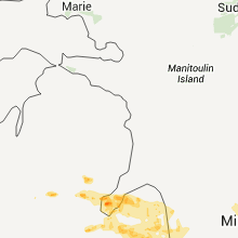
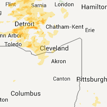
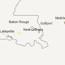
Hail Map for Saturday, July 2, 2011

Number of Impacted Households on 7/2/2011
0
Impacted by 1" or Larger Hail
0
Impacted by 1.75" or Larger Hail
0
Impacted by 2.5" or Larger Hail
Square Miles of Populated Area Impacted on 7/2/2011
0
Impacted by 1" or Larger Hail
0
Impacted by 1.75" or Larger Hail
0
Impacted by 2.5" or Larger Hail


Cities Most Affected by Hail Storms of 7/2/2011
| Hail Size | Demographics of Zip Codes Affected | ||||||
|---|---|---|---|---|---|---|---|
| City | Count | Average | Largest | Pop Density | House Value | Income | Age |
| Ellsworth, KS | 4 | 1.94 | 2.50 | 13 | $48k | $37.4k | 39.8 |
| Torrington, WY | 3 | 1.92 | 2.00 | 13 | $79k | $33.0k | 43.0 |
| Upton, WY | 2 | 1.75 | 1.75 | 0 | $68k | $34.9k | 41.3 |
| Walkerton, IN | 1 | 2.00 | 2.00 | 91 | $81k | $40.4k | 42.0 |
| Lagrange, IN | 1 | 2.00 | 2.00 | 104 | $94k | $41.1k | 31.4 |
| Overland Park, KS | 1 | 2.00 | 2.00 | 4283 | $131k | $50.6k | 38.4 |
| Ypsilanti, MI | 1 | 2.00 | 2.00 | 1158 | $95k | $41.0k | 34.0 |
| Arapahoe, CO | 1 | 1.75 | 1.75 | 0 | $72k | $40.9k | 37.0 |
| Manville, WY | 1 | 1.75 | 1.75 | 0 | $48k | $20.9k | 55.1 |
| Westland, MI | 1 | 1.75 | 1.75 | 4087 | $128k | $43.9k | 39.4 |
| Ekalaka, MT | 1 | 1.75 | 1.75 | 0 | $23k | $25.4k | 50.1 |
| Rogersville, MO | 1 | 1.75 | 1.75 | 98 | $111k | $40.7k | 39.9 |
| Nashua, MT | 1 | 1.75 | 1.75 | 1 | $39k | $26.9k | 51.6 |
| Lyman, NE | 1 | 1.75 | 1.75 | 3 | $29k | $27.0k | 40.9 |
| Cascade, CO | 1 | 1.75 | 1.75 | 24 | $170k | $46.8k | 48.6 |
| Yuma, CO | 1 | 1.75 | 1.75 | 7 | $84k | $32.3k | 37.1 |
Hail and Wind Damage Spotted on 7/2/2011
Filter by Report Type:Hail ReportsWind Reports
States Impacted
Alabama, Florida, Georgia, South Carolina, Michigan, Louisiana, Indiana, Texas, Kansas, Montana, Arizona, Wyoming, Oklahoma, Arkansas, Colorado, Missouri, South Dakota, Illinois, Nebraska, Ohio, Virginia, North Dakota, New JerseyAlabama
| Local Time | Report Details |
|---|---|
| 5:56 PM UTC | Mobile regional airport asos reported a 61 mph wind gus in mobile county AL, 11.1 miles W of Mobile, AL |
| 6:20 PM UTC | Minor damage to mobile homes. tress and power lines dow in escambia county AL, 36.4 miles NE of Mobile, AL |
| 7:05 PM UTC | The main roof of the exxon station on hwy 59 collapsed. time estimated by rada in baldwin county AL, 17.6 miles E of Mobile, AL |
| 7:05 PM UTC | Quarter sized hail reported near Loxley, AL, 17.6 miles E of Mobile, AL, quarter size hail on hwy 59 near i-10. |
| 8:58 PM UTC | Tree down at mixons crossroads in coffee county AL, 80.5 miles NNE of Miramar Beach, FL |
| 9:05 PM UTC | Tree down along highway 167 near mile marker 45 in coffee county AL, 75.1 miles NNE of Miramar Beach, FL |
| 9:30 PM UTC | A portion of a privacy was blown down. winds estimated at 40 mp in elmore county AL, 42.7 miles W of Auburn, AL |
| 10:18 PM UTC | One dead tree down in cuba as well as several large limbs. winds estimated up to 40 mp in sumter county AL, 70.3 miles WNW of Camden, AL |
| 10:18 PM UTC | One tree down in cuba. winds estimated at 40 to 50 mp in sumter county AL, 70.3 miles WNW of Camden, AL |
| 11:35 PM UTC | Several trees and power lines down along highway 95 south between abbeville and halebur in henry county AL, 79.9 miles SSE of Auburn, AL |
| 11:45 PM UTC | Report of structural damage along highway 10 west near abbeville in henry county AL, 72.8 miles S of Auburn, AL |
| 11:46 PM UTC | One tree blown onto garage...as well as large limbs onto street. winds estimated by spotter to be 40 to 50 mp in russell county AL, 24.5 miles ESE of Auburn, AL |
Florida
| Local Time | Report Details |
|---|---|
| 6:10 PM UTC | Power lines down on able ave and woodbine road near pac in santa rosa county FL, 51.7 miles WNW of Miramar Beach, FL |
| 6:10 PM UTC | Power lines down on john hamm road in east milto in santa rosa county FL, 39.3 miles WNW of Miramar Beach, FL |
| 7:28 PM UTC | Quarter sized hail reported near Defuniak Springs, FL, 17.3 miles NNE of Miramar Beach, FL, public called in a report to law enforcement of hail estimated at quarter size in the vicinity of rock hill road and eglin territory site c-6 road. |
| 7:28 PM UTC | Public called in a report to law enforcement of winds estimated at 60 mph in the vicinity of rock hill road and eglin territory site c-6 roa in walton county FL, 17.3 miles NNE of Miramar Beach, FL |
Georgia
| Local Time | Report Details |
|---|---|
| 7:30 PM UTC | 1 tree down in washington county GA, 59.3 miles SW of Augusta, GA |
| 10:53 PM UTC | A few power lines were down along cedar springs road south of blakel in early county GA, 74.3 miles NNW of Tallahassee, FL |
| 11:15 PM UTC | Several trees down across the far north central and northeast part of the county...especially near chappel mill. some roads were blocked for a brief period...including in lamar county GA, 42.6 miles SSE of Atlanta, GA |
| 11:45 PM UTC | Three trees down...one on a house...one on a power line and a road...and another down on a road. occurred between 745 pm and 815 pm ed in pike county GA, 39.2 miles S of Atlanta, GA |
South Carolina
| Local Time | Report Details |
|---|---|
| 7:38 PM UTC | Sc highway patrol reports a tree down on cross swamp rd near the intersection of moselle rd in colleton county SC, 59.7 miles WSW of Charleston, SC |
| 8:09 PM UTC | Quarter sized hail reported near , , 16.8 miles N of Charleston, SC, nickel to quarter size hail reported near colonel maham drive. time estimated by radar. |
| 8:45 PM UTC | Trees reported down on railroad tracks in lexington county SC, 40.9 miles NE of Augusta, GA |
| 8:45 PM UTC | Quarter sized hail reported near Batesburg-Leesville, SC, 38 miles NE of Augusta, GA, nickel to quarter size hail reported |
| 8:47 PM UTC | Structural damage at apartment complex on pinewood dr. due to fallen trees in lexington county SC, 39.2 miles NE of Augusta, GA |
| 8:47 PM UTC | Trees reported down on powerlines on summerland ave in lexington county SC, 40.8 miles NE of Augusta, GA |
Michigan
| Local Time | Report Details |
|---|---|
| 8:19 PM UTC | Quarter sized hail reported near , , 34.8 miles NNW of Flint, MI |
| 8:53 PM UTC | Central dispatch reports trees down in the area in huron county MI, 60.1 miles NNE of Flint, MI |
| 9:00 PM UTC | 4 inch diameter limbs downe in huron county MI, 60.1 miles NNE of Flint, MI |
| 9:06 PM UTC | Central dispatch reports trees down in the area in huron county MI, 60.3 miles NNE of Flint, MI |
| 9:12 PM UTC | Quarter sized hail reported near Vienna, MI, 9.6 miles N of Flint, MI |
| 9:14 PM UTC | Central dispatch reports trees down in the area in huron county MI, 53.9 miles NNE of Flint, MI |
| 9:15 PM UTC | Large limbs downed. also pea size hai in huron county MI, 67.3 miles NNE of Flint, MI |
| 9:22 PM UTC | Central dispatch reports trees down in the area in huron county MI, 64.5 miles NNE of Flint, MI |
| 9:31 PM UTC | Quarter sized hail reported near Forest, MI, 12.7 miles NNE of Flint, MI |
| 9:37 PM UTC | Quarter sized hail reported near Cassopolis, MI, 74.5 miles NW of Fort Wayne, IN, hail ranging in size from dime sized to quarter sized. |
| 9:39 PM UTC | Central dispatch reports trees down in the area in lapeer county MI, 17.4 miles NE of Flint, MI |
| 9:39 PM UTC | Central dispatch reports three trees down in the area in tuscola county MI, 37.2 miles NE of Flint, MI |
| 9:39 PM UTC | Central dispatch reports trees down in the area in huron county MI, 61.5 miles NE of Flint, MI |
| 9:41 PM UTC | Central dispatch reports trees down in the area in lapeer county MI, 22.3 miles NE of Flint, MI |
| 9:47 PM UTC | Central dispatch reports numerous trees down blocking roads in a four to five mile are in huron county MI, 75.6 miles NE of Flint, MI |
| 9:51 PM UTC | Trees and wires/poles dow in lapeer county MI, 23.1 miles ENE of Flint, MI |
| 10:11 PM UTC | Quarter sized hail reported near White Pigeon, MI, 56.2 miles NNW of Fort Wayne, IN |
| 10:11 PM UTC | Central dispatch reports trees down in the area in lapeer county MI, 32.9 miles ENE of Flint, MI |
| 10:19 PM UTC | Central dispatch reports trees down in the area in lapeer county MI, 26.7 miles E of Flint, MI |
| 10:25 PM UTC | Poles and powerlines down in oakland county MI, 15.9 miles SE of Flint, MI |
| 10:25 PM UTC | Trees and powerlines down in oakland county MI, 16.8 miles SE of Flint, MI |
| 10:26 PM UTC | 3 to 4 inch diameter limbs down. pea size hail also reporte in sanilac county MI, 58.2 miles ENE of Flint, MI |
| 10:30 PM UTC | Central dispatch reports numerous trees and powerlines down in the area in sanilac county MI, 56.8 miles ENE of Flint, MI |
| 10:46 PM UTC | Central dispatch reports trees down in the area in lapeer county MI, 33.3 miles E of Flint, MI |
| 10:49 PM UTC | Numerous trees down across the county in st. clair county MI, 44.4 miles E of Flint, MI |
| 11:01 PM UTC | Storm damage reported in oakland county MI, 27.3 miles SE of Flint, MI |
| 11:07 PM UTC | Three foot diameter trees down in oakland county MI, 31.6 miles ESE of Flint, MI |
| 11:10 PM UTC | Quarter sized hail reported near Commerce, MI, 32.3 miles SSE of Flint, MI, also estimated 55 mph wind gust. |
| 11:35 PM UTC | Trees and powerlines down in macomb county MI, 47.6 miles ESE of Flint, MI |
| 11:36 PM UTC | Quarter sized hail reported near Canton, MI, 48.7 miles SSE of Flint, MI |
| 11:38 PM UTC | Quarter sized hail reported near Canton, MI, 51.5 miles SSE of Flint, MI |
| 11:41 PM UTC | Ping Pong Ball sized hail reported near Westland, MI, 50.4 miles SSE of Flint, MI |
| 11:42 PM UTC | Golf Ball sized hail reported near Westland, MI, 49.4 miles SSE of Flint, MI |
| 11:46 PM UTC | Trees and powerlines down in wayne county MI, 50 miles SSE of Flint, MI |
| 11:46 PM UTC | Quarter sized hail reported near Westland, MI, 51.3 miles SSE of Flint, MI |
| 11:46 PM UTC | Quarter sized hail reported near Garden City, MI, 50 miles SSE of Flint, MI |
| 11:48 PM UTC | Numerous limbs down ranging from 4 to 6 inches in diamete in wayne county MI, 54.8 miles SSE of Flint, MI |
| 11:50 PM UTC | Quarter sized hail reported near Van Buren, MI, 54.8 miles S of Flint, MI |
| 11:57 PM UTC | Branches down ranging from 3 to 6 inch diameter. powerlines also dow in wayne county MI, 56.9 miles S of Flint, MI |
| 12:01 AM UTC | Measured at metro airport in wayne county MI, 56.9 miles SSE of Flint, MI |
| 12:07 AM UTC | One foot diameter limb down in st. clair county MI, 64.3 miles ESE of Flint, MI |
| 12:08 AM UTC | Quarter sized hail reported near Pittsfield, MI, 56 miles S of Flint, MI |
| 12:16 AM UTC | Hen Egg sized hail reported near Ypsilanti, MI, 55 miles S of Flint, MI |
| 12:26 AM UTC | Measured at willow run airport in wayne county MI, 54.5 miles S of Flint, MI |
| 12:36 AM UTC | Quarter sized hail reported near Southgate, MI, 61.2 miles SSE of Flint, MI |
| 12:45 AM UTC | Quarter sized hail reported near Trenton, MI, 63.7 miles SSE of Flint, MI |
| 12:45 AM UTC | Storm damage reported in wayne county MI, 63.7 miles SSE of Flint, MI |
| 12:45 AM UTC | Grosse ile police reported trees and limbs down across the north part of the islan in wayne county MI, 64.8 miles SSE of Flint, MI |
| 1:00 AM UTC | Grosse ile police reported trees and limbs down across the south part of the islan in wayne county MI, 66.9 miles SSE of Flint, MI |
| 1:10 AM UTC | 10 inch diameter tree down in monroe county MI, 75.6 miles S of Flint, MI |
| 1:10 AM UTC | 1/2 inch hail also reported in wayne county MI, 68.6 miles SSE of Flint, MI |
| 1:24 AM UTC | Trees and wires downed in monroe county MI, 76.4 miles S of Flint, MI |
| 1:26 AM UTC | Large limbs downed in monroe county MI, 76.2 miles SSE of Flint, MI |
| 1:28 AM UTC | Trees and wires downe in monroe county MI, 76.9 miles SSE of Flint, MI |
Louisiana
| Local Time | Report Details |
|---|---|
| 8:25 PM UTC | Terrebonne parish emergency manager reported downed trees...downed power lines and a overturned trailer home in the bobtown community along grand calliou roa in terrebonne county LA, 52 miles SW of New Orleans, LA |
Indiana
| Local Time | Report Details |
|---|---|
| 8:45 PM UTC | Quarter sized hail reported near La Porte, IN, 49.9 miles ESE of Chicago, IL, hail still falling at time of report |
| 8:48 PM UTC | Quarter sized hail reported near La Porte, IN, 50.4 miles ESE of Chicago, IL |
| 9:20 PM UTC | Hen Egg sized hail reported near Walkerton, IN, 60 miles ESE of Chicago, IL, received picture of hail greater than 2.25 inches in mill creek. relayed by wndu. |
| 9:29 PM UTC | Quarter sized hail reported near La Porte, IN, 55.9 miles ESE of Chicago, IL, ranges from pea to quarter size. |
| 10:01 PM UTC | Quarter sized hail reported near San Pierre, IN, 60.9 miles SE of Chicago, IL |
| 10:12 PM UTC | Large tree limb fell and destroyed patio furniture in starke county IN, 63.7 miles SE of Chicago, IL |
| 10:30 PM UTC | Hen Egg sized hail reported near Lagrange, IN, 42.4 miles NNW of Fort Wayne, IN |
| 10:40 PM UTC | Healthy 12 to 18 inch diameter tree down at intersection of cr 400 e and 750 in kosciusko county IN, 39.4 miles WNW of Fort Wayne, IN |
| 10:51 PM UTC | Large farm field irrigation system twisted and overturne in kosciusko county IN, 44.9 miles WNW of Fort Wayne, IN |
| 11:10 PM UTC | Trees down and powerlines down throughout the city. trees down at 300 w and sr 114. trees down at 625 w north of 16. trees down at college av in wabash county IN, 35.4 miles W of Fort Wayne, IN |
| 11:15 PM UTC | Large tree across elslsworth st. power lines down at 2070 east linker st. tree across road at 275 w and sr 205. tree across road 8797w and sr 14. s chauncy st large lim in whitley county IN, 21.2 miles WNW of Fort Wayne, IN |
| 11:36 PM UTC | Tree down and power lines down on sr 17 n of kewanna...corrected for time in fulton county IN, 68.5 miles W of Fort Wayne, IN |
| 11:37 PM UTC | Tree down across the road on 625n in whitley county IN, 28.6 miles WNW of Fort Wayne, IN |
| 12:10 AM UTC | Numerous trees down in cass county IN, 62 miles WSW of Fort Wayne, IN |
| 12:15 AM UTC | Tree down and power lines down on sr 17 n of kewanna in fulton county IN, 68.5 miles W of Fort Wayne, IN |
| 2:00 AM UTC | Trees down in the buck creek area in tippecanoe county IN, 59.2 miles NW of Indianapolis, IN |
| 2:01 AM UTC | Tree limbs down in sedalia in clinton county IN, 48.3 miles NNW of Indianapolis, IN |
| 2:31 AM UTC | Trees and power lines down near the intersection of 200s and 500w. time approximat in boone county IN, 26.2 miles NW of Indianapolis, IN |
| 4:05 AM UTC | Quarter sized hail reported near Lizton, IN, 22.4 miles WNW of Indianapolis, IN |
| 7:00 AM UTC | Several tree limbs down and a trampoline wrapped around a tree and fence. damage likely from winds near 45 to 50 mp in knox county IN, 49 miles N of Evansville, IN |
Texas
| Local Time | Report Details |
|---|---|
| 9:07 PM UTC | Trees and limbs reported down near myrtle drive in jackson in cherokee county TX, 53.7 miles NW of Lufkin, TX |
| 9:15 PM UTC | 14 inch tree down in anderson county in anderson county TX, 70.7 miles NW of Lufkin, TX |
| 9:39 PM UTC | Roof blown off a mobile home west of tennessee colony in anderson county TX, 76.3 miles WNW of Lufkin, TX |
| 9:40 PM UTC | Trees up to 12 inches in diameter were blown down into 2 houses and power lines in fannin county TX, 56.8 miles SSE of Atoka, OK |
| 11:00 PM UTC | Barn roof torn off; power poles down in collin county TX, 39.7 miles NE of Dallas, TX |
| 11:45 PM UTC | Trees and powerlines blown down. tree down on a ca in montgomery county TX, 32.8 miles NNE of Houston, TX |
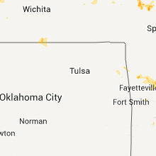
Kansas
| Local Time | Report Details |
|---|---|
| 9:38 PM UTC | Measured wind to 55 mph in the same are in sumner county KS, 41.1 miles SSE of Wichita, KS |
| 9:58 PM UTC | Quarter sized hail reported near Reading, KS, 51.2 miles SE of Manhattan, KS |
| 10:00 PM UTC | Roof blown off of machine shed. winds estimated at 60 mph. delayed repor in lyon county KS, 50.5 miles SSE of Manhattan, KS |
| 10:25 PM UTC | Storm damage reported in cowley county KS, 45.6 miles SSE of Wichita, KS |
| 10:33 PM UTC | Power pole and lines down just west of downtow in cowley county KS, 45.6 miles SSE of Wichita, KS |
| 10:34 PM UTC | Fireworks stand blown over on state line south of arkansas cit in cowley county KS, 49.4 miles SSE of Wichita, KS |
| 10:38 PM UTC | Large tree down just east of downtow in cowley county KS, 45.6 miles SSE of Wichita, KS |
| 12:39 AM UTC | Quarter sized hail reported near Great Bend, KS, 46.4 miles SSE of Hays, KS |
| 12:55 AM UTC | Storm damage reported in barton county KS, 44.4 miles SE of Hays, KS |
| 12:58 AM UTC | Golf Ball sized hail reported near Ellsworth, KS, 60.8 miles ESE of Hays, KS |
| 1:00 AM UTC | Ping Pong Ball sized hail reported near Ellsworth, KS, 61 miles ESE of Hays, KS |
| 1:06 AM UTC | Storm damage reported in cheyenne county KS, 42.7 miles ESE of Yuma, CO |
| 1:06 AM UTC | Updated to include wind dmg. 4 inch tree limbs down and lots of 2 to 3 inch tree limbs dow in cheyenne county KS, 42.7 miles ESE of Yuma, CO |
| 1:09 AM UTC | Golf Ball sized hail reported near Ellsworth, KS, 64.1 miles ESE of Hays, KS |
| 1:10 AM UTC | Ping Pong Ball sized hail reported near Ellsworth, KS, 60.2 miles E of Hays, KS |
| 1:15 AM UTC | Tennis Ball sized hail reported near Ellsworth, KS, 60.2 miles E of Hays, KS |
| 1:25 AM UTC | Storm damage reported in cheyenne county KS, 51.1 miles NW of Colby, KS |
| 1:30 AM UTC | Golf Ball sized hail reported near Ellsworth, KS, 60.2 miles E of Hays, KS, windows broken out near golf course. |
| 2:06 AM UTC | Relayed through henry dieh in ellsworth county KS, 70.3 miles E of Hays, KS |
| 2:06 AM UTC | Relayed through henry dieh in lincoln county KS, 70.2 miles E of Hays, KS |
| 2:15 AM UTC | 5 inch diameter green tree limbs down in rawlins county KS, 33.6 miles N of Colby, KS |
| 2:15 AM UTC | 5 inch diameter green treen limbs down in rawlins county KS, 33.6 miles N of Colby, KS |
| 2:35 AM UTC | Semi blown off interstate 70 at location. firefighters estimated wind speeds between 60 and 70 mph. 1.70 inches of rainfall was also measure in gove county KS, 23.9 miles SE of Colby, KS |
| 2:40 AM UTC | Quarter sized hail reported near Tescott, KS, 71.8 miles W of Manhattan, KS, radar estimated time. delayed report. |
| 3:00 AM UTC | Several trees uprooted. house had part of roof blown off. several power poles broken of in decatur county KS, 40.1 miles NE of Colby, KS |
| 3:16 AM UTC | Storm damage reported in rawlins county KS, 37.9 miles NNE of Colby, KS |
| 3:24 AM UTC | Ksn weather network in decatur county KS, 40.1 miles NE of Colby, KS |
| 3:24 AM UTC | Storm damage reported in decatur county KS, 44.2 miles NNE of Colby, KS |
| 3:24 AM UTC | Siding ripped off a retail store in decatur county KS, 40.1 miles NE of Colby, KS |
| 3:25 AM UTC | 5 inch diameter tree limbs down in decatur county KS, 40.1 miles NE of Colby, KS |
| 3:28 AM UTC | Storm damage reported in decatur county KS, 44.2 miles NNE of Colby, KS |
| 11:08 PM CDT | Hen Egg sized hail reported near Overland Park, KS, 12.9 miles SSW of Kansas City, MO, hail dents on car |
| 11:09 PM CDT | Quarter sized hail reported near Overland Park, KS, 12.9 miles SSW of Kansas City, MO, at i-435 and highway 69 |
| 11:10 PM CDT | Ping Pong Ball sized hail reported near Lenexa, KS, 15 miles SW of Kansas City, MO, delayed report from 97th and quivira |
| 4:14 AM UTC | Quarter sized hail reported near Lenexa, KS, 14.6 miles SW of Kansas City, MO, intersection of college and pflumm |
| 4:18 AM UTC | Ksn mesonet in norton county KS, 68.8 miles ENE of Colby, KS |
| 4:23 AM UTC | Storm damage reported in decatur county KS, 55.3 miles NE of Colby, KS |
| 4:23 AM UTC | Storm damage reported in norton county KS, 69.1 miles ENE of Colby, KS |
| 4:23 AM UTC | Storm damage reported in norton county KS, 68.8 miles ENE of Colby, KS |
| 4:25 AM UTC | Five electric poles were down just west of lorett in rush county KS, 17.1 miles SSE of Hays, KS |
| 4:25 AM UTC | Quarter sized hail reported near Gaylord, KS, 59.6 miles NNE of Hays, KS |
| 4:25 AM UTC | Ping Pong Ball sized hail reported near Bison, KS, 17.3 miles SSE of Hays, KS, hail up to the size of ping pongs covered the ground. |
| 4:30 AM UTC | Tree limbs one inch in diameter were down. winds were estimated at 60 mp in rush county KS, 19 miles SSE of Hays, KS |
| 4:32 AM UTC | Ksn weather network in norton county KS, 73.2 miles NNW of Hays, KS |
Montana
| Local Time | Report Details |
|---|---|
| 9:50 PM UTC | Quarter sized hail reported near Alzada, MT, 60.8 miles NNE of Gillette, WY |
| 12:43 AM UTC | Golf Ball sized hail reported near Nashua, MT, 13.8 miles SE of Glasgow, MT |
| 12:44 AM UTC | Quarter sized hail reported near Fort Peck, MT, 15.4 miles SE of Glasgow, MT |
| 12:50 AM UTC | Ping Pong Ball sized hail reported near Ismay, MT, 56.2 miles ESE of Miles City, MT |
| 12:50 AM UTC | Golf Ball sized hail reported near Ekalaka, MT, 53.3 miles ESE of Miles City, MT, damaging hail with many broken windows and house siding is gone. |
| 1:05 AM UTC | Quarter sized hail reported near Volborg, MT, 54.7 miles SE of Miles City, MT, additional hail report |
Arizona
| Local Time | Report Details |
|---|---|
| 10:00 PM UTC | *** 1 inj *** woman injured by a falling large tree limb at superstition springs mall. time is estimate in maricopa county AZ, 22.7 miles E of Phoenix, AZ |
Wyoming
| Local Time | Report Details |
|---|---|
| 10:10 PM UTC | Ping Pong Ball sized hail reported near Sundance, WY, 46.4 miles E of Gillette, WY |
| 10:15 PM UTC | Golf Ball sized hail reported near Upton, WY, 45.5 miles ESE of Gillette, WY, large hail damaged homes and vehicles. |
| 10:17 PM UTC | Golf Ball sized hail reported near Upton, WY, 45.9 miles ESE of Gillette, WY |
| 10:25 PM UTC | Quarter sized hail reported near Lost Springs, WY, 71.8 miles E of Casper, WY |
| 11:05 PM UTC | Ping Pong Ball sized hail reported near Newcastle, WY, 66.3 miles SE of Gillette, WY |
| 11:10 PM UTC | Half Dollar sized hail reported near Douglas, WY, 67.2 miles SSE of Gillette, WY |
| 11:25 PM UTC | Golf Ball sized hail reported near Manville, WY, 75.2 miles NW of Scottsbluff, NE, mainly pea to dime sized hail. a few larger stones between quarter and golf ball size. accompanied by very heavy rain and strong winds. |
| 11:28 PM UTC | Quarter sized hail reported near Newcastle, WY, 65 miles SE of Gillette, WY, lasted five minutes |
| 12:00 AM UTC | Quarter sized hail reported near Newcastle, WY, 56.9 miles E of Gillette, WY, 0.75 inches of rain with storm |
| 1:09 AM UTC | Golf Ball sized hail reported near Torrington, WY, 30.3 miles WNW of Scottsbluff, NE, near port of entry area |
| 1:17 AM UTC | Hen Egg sized hail reported near Torrington, WY, 30.3 miles WNW of Scottsbluff, NE |
| 1:18 AM UTC | Quarter sized hail reported near Torrington, WY, 30.3 miles WNW of Scottsbluff, NE |
| 1:20 AM UTC | Quarter sized hail reported near Torrington, WY, 30.3 miles WNW of Scottsbluff, NE |
| 1:21 AM UTC | Storm damage reported in goshen county WY, 30.3 miles WNW of Scottsbluff, NE |
| 1:29 AM UTC | Half Dollar sized hail reported near Torrington, WY, 29.6 miles WNW of Scottsbluff, NE |
| 1:30 AM UTC | Hen Egg sized hail reported near Torrington, WY, 23.8 miles WNW of Scottsbluff, NE, from cocorahs observer |
| 2:11 AM UTC | Half Dollar sized hail reported near Yoder, WY, 26.3 miles W of Scottsbluff, NE |
Oklahoma
| Local Time | Report Details |
|---|---|
| 10:30 PM UTC | Emergency management spotters estimated winds of 65 mph near us-81 and phillips. roof and tree damage is also being reporte in garfield county OK, 70.2 miles NNW of Oklahoma City, OK |
| 10:30 PM UTC | One mile strech of power poles snapped at the base between breckenridge road and phillips road along north 30th street in garfield county OK, 69.8 miles NNW of Oklahoma City, OK |
| 10:34 PM UTC | Fireworks stand blown over at the state line with a person trapped under the debri in kay county OK, 51.1 miles SSE of Wichita, KS |
Arkansas
| Local Time | Report Details |
|---|---|
| 10:44 PM UTC | Tree limbs down on highway 412 1 mile west of bypas in washington county AR, 56.4 miles NNE of Fort Smith, AR |
Colorado
| Local Time | Report Details |
|---|---|
| 4:45 PM MDT | Golf Ball sized hail reported near Green Mountain Falls, CO, 51 miles NNW of Pueblo, CO |
| 10:55 PM UTC | Quarter sized hail reported near Colorado Springs, CO, 42.4 miles NNW of Pueblo, CO |
| 11:02 PM UTC | Quarter sized hail reported near Colorado Springs, CO, 42.3 miles NNW of Pueblo, CO |
| 11:04 PM UTC | Quarter sized hail reported near Colorado Springs, CO, 44 miles NNW of Pueblo, CO |
| 11:09 PM UTC | Quarter sized hail reported near Colorado Springs, CO, 42.4 miles NNW of Pueblo, CO |
| 11:22 PM UTC | Akron asos reported peak gust of 67 mp in washington county CO, 25.9 miles W of Yuma, CO |
| 11:30 PM UTC | Also reported nickle size hail in washington county CO, 23.1 miles W of Yuma, CO |
| 11:33 PM UTC | Quarter sized hail reported near Otis, CO, 14 miles WNW of Yuma, CO |
| 11:46 PM UTC | Quarter sized hail reported near Akron, CO, 25.9 miles W of Yuma, CO, also heavy rain along with pea to marble size hail. |
| 11:49 PM UTC | Limon asos reported peak wind gust 68 mph at 1749 mdt in lincoln county CO, 76.8 miles ESE of Denver, CO |
| 12:06 AM UTC | Quarter sized hail reported near Akron, CO, 20.7 miles W of Yuma, CO, also heavy rain. estimated 1 inch in 30 minutes. |
| 12:09 AM UTC | Golf Ball sized hail reported near Arapahoe, CO, 71.3 miles WSW of Colby, KS |
| 12:27 AM UTC | Storm damage reported in yuma county CO, 26.3 miles E of Yuma, CO |
| 1:00 AM UTC | Storm damage reported in kit carson county CO, 54.2 miles SSW of Yuma, CO |
| 1:01 AM UTC | Golf Ball sized hail reported near Yuma, CO, 21.3 miles S of Yuma, CO |
Missouri
| Local Time | Report Details |
|---|---|
| 11:28 PM UTC | Golf Ball sized hail reported near Rogersville, MO, 9.6 miles E of Springfield, MO, delayed report. golf ball size hail covered the ground up to an hour after falling. hail size unknown at time of occurrence. hail destroyed fruit trees and crops at a l |
| 12:10 AM UTC | Quarter sized hail reported near Osceola, MO, 61.4 miles NNW of Springfield, MO |
| 12:30 AM UTC | Half Dollar sized hail reported near Harwood, MO, 70.5 miles NW of Springfield, MO, several trees down on highway aa. report of quarter to half dollar sized hail |
| 1:03 AM UTC | Quarter sized hail reported near El Dorado Springs, MO, 56.2 miles NW of Springfield, MO |
| 1:28 AM UTC | Quarter sized hail reported near Harwood, MO, 71.6 miles NW of Springfield, MO, quarter size hail covering the ground. |
| 3:11 AM UTC | Quarter sized hail reported near Drexel, MO, 43 miles S of Kansas City, MO |
South Dakota
| Local Time | Report Details |
|---|---|
| 12:04 AM UTC | Quarter sized hail reported near Whitewood, SD, 33.1 miles NW of Rapid City, SD, most of the hail that covered the ground was dime size |
| 12:17 AM UTC | Quarter sized hail reported near Hermosa, SD, 21.7 miles S of Rapid City, SD |
| 12:57 AM UTC | Storm damage reported in custer county SD, 27 miles S of Rapid City, SD |
| 1:05 AM UTC | Storm damage reported in fall river county SD, 48.6 miles S of Rapid City, SD |
| 1:10 AM UTC | Storm damage reported in pennington county SD, 20.6 miles ESE of Rapid City, SD |
| 1:15 AM UTC | Half Dollar sized hail reported near Fairburn, SD, 29.2 miles SSE of Rapid City, SD |
Illinois
| Local Time | Report Details |
|---|---|
| 1:10 AM UTC | Van blown off i 74 at mile marker 20 in vermilion county IL, 53.7 miles NE of Mattoon, IL |
| 2:00 AM UTC | Numerous trees blown dow in vermilion county IL, 52.1 miles NE of Mattoon, IL |
| 4:04 AM UTC | Tree limbs down around charlesto in coles county IL, 10.5 miles E of Mattoon, IL |
Nebraska
| Local Time | Report Details |
|---|---|
| 1:45 AM UTC | Had couple of 6 inch diameter green tree limbs broken of in dundy county NE, 52.9 miles E of Yuma, CO |
| 1:59 AM UTC | Golf Ball sized hail reported near Lyman, NE, 19.9 miles WNW of Scottsbluff, NE |
| 2:00 AM UTC | Quarter sized hail reported near Mitchell, NE, 12.9 miles WNW of Scottsbluff, NE, no rotation. |
| 2:00 AM UTC | Half Dollar sized hail reported near Culbertson, NE, 58.5 miles N of Colby, KS, dime to half dollar sized hail reported along with heavy rain with thunderstorm |
| 2:16 AM UTC | Quarter sized hail reported near Lyman, NE, 19.9 miles WNW of Scottsbluff, NE |
| 2:35 AM UTC | Quarter sized hail reported near Harrisburg, NE, 23.6 miles SW of Scottsbluff, NE |
| 3:45 AM UTC | Half Dollar sized hail reported near Moorefield, NE, 58.5 miles SSE of North Platte, NE, occurred for 15 to 30 mins |
Ohio
| Local Time | Report Details |
|---|---|
| 1:55 AM UTC | Large tree branch down on clyde road. branch covering both lanes of the roa in lake county OH, 37.9 miles ENE of Cleveland, OH |
| 2:40 AM UTC | Large branches broke in cuyahoga county OH, 1.8 miles SSE of Cleveland, OH |
| 3:00 AM UTC | Trees down across southern part of town. one down on n ridge road. power outages reported across town as a resul in lorain county OH, 33.3 miles W of Cleveland, OH |
Virginia
| Local Time | Report Details |
|---|---|
| 4:08 AM UTC | Trees down in gloucester county VA, 52.1 miles NNW of Virginia Beach, VA |
| 8:00 AM UTC | Quarter sized hail reported near Luray, VA, 80.6 miles ESE of Elkins, WV |
North Dakota
| Local Time | Report Details |
|---|---|
| 5:00 AM UTC | Quarter sized hail reported near Noonan, ND, 53.8 miles NNE of Williston, ND |
New Jersey
| Local Time | Report Details |
|---|---|
| 7:30 AM UTC | Some tree damage and minor house damage in sussex county NJ, 41.2 miles NW of Brooklyn, NY |
Connect with Interactive Hail Maps