

Hail Map for Sunday, May 15, 2022

Number of Impacted Households on 5/15/2022
0
Impacted by 1" or Larger Hail
0
Impacted by 1.75" or Larger Hail
0
Impacted by 2.5" or Larger Hail
Square Miles of Populated Area Impacted on 5/15/2022
0
Impacted by 1" or Larger Hail
0
Impacted by 1.75" or Larger Hail
0
Impacted by 2.5" or Larger Hail


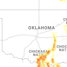


Cities Most Affected by Hail Storms of 5/15/2022
| Hail Size | Demographics of Zip Codes Affected | ||||||
|---|---|---|---|---|---|---|---|
| City | Count | Average | Largest | Pop Density | House Value | Income | Age |
| Okemah, OK | 5 | 3.05 | 4.50 | 19 | $42k | $23.8k | 40.2 |
| Wetumka, OK | 3 | 2.42 | 3.00 | 13 | $32k | $22.1k | 43.3 |
| Gulfport, MS | 3 | 2.08 | 2.50 | 416 | $87k | $40.5k | 33.9 |
| Ada, OK | 3 | 2.00 | 2.25 | 101 | $62k | $27.0k | 34.4 |
| Atwood, OK | 2 | 2.35 | 2.50 | 9 | $29k | $31.4k | 49.6 |
| Muskogee, OK | 2 | 1.88 | 2.00 | 278 | $62k | $30.7k | 37.6 |
| Fittstown, OK | 2 | 1.88 | 2.00 | 0 | $37k | $30.0k | 44.5 |
| Belle Chasse, LA | 2 | 1.88 | 2.00 | 272 | $153k | $45.7k | 35.0 |
| Gore, OK | 1 | 2.50 | 2.50 | 37 | $57k | $28.6k | 43.8 |
| Davenport, FL | 1 | 2.00 | 2.00 | 516 | $106k | $39.2k | 39.8 |
| Park Hill, OK | 1 | 2.00 | 2.00 | 53 | $73k | $27.3k | 43.5 |
| Centreville, AL | 1 | 1.75 | 1.75 | 38 | $83k | $33.6k | 40.1 |
| Burneyville, OK | 1 | 1.75 | 1.75 | 13 | $83k | $36.7k | 48.1 |
| Allen, OK | 1 | 1.75 | 1.75 | 11 | $38k | $26.0k | 41.3 |
| Ponca, AR | 1 | 1.75 | 1.75 | 7 | $0k | $0.0k | 48.8 |
| Russellville, AR | 1 | 1.75 | 1.75 | 161 | $83k | $38.7k | 38.0 |
| Wister, OK | 1 | 1.75 | 1.75 | 11 | $42k | $27.4k | 40.3 |
| Mill Creek, OK | 1 | 1.75 | 1.75 | 4 | $32k | $29.2k | 40.5 |
| Sallisaw, OK | 1 | 1.75 | 1.75 | 71 | $61k | $26.3k | 38.4 |
| Park Hills, MO | 1 | 1.75 | 1.75 | 292 | $58k | $28.7k | 35.3 |
| Muenster, TX | 1 | 1.75 | 1.75 | 11 | $80k | $43.9k | 39.5 |
| Shady Point, OK | 1 | 1.75 | 1.75 | 41 | $52k | $31.2k | 37.7 |
| Osage City, KS | 1 | 1.75 | 1.75 | 27 | $72k | $35.6k | 42.1 |
| Allen, TX | 1 | 1.75 | 1.75 | 2295 | $197k | $100.1k | 35.4 |
| Wilson, OK | 1 | 1.75 | 1.75 | 17 | $38k | $26.5k | 38.5 |
Hail and Wind Damage Spotted on 5/15/2022
Filter by Report Type:Hail ReportsWind Reports
States Impacted
Kansas, Missouri, Arkansas, Florida, Pennsylvania, Georgia, New York, Oklahoma, Tennessee, Alabama, Louisiana, Virginia, Mississippi, Oregon, Texas, IdahoKansas
| Local Time | Report Details |
|---|---|
| 7:02 AM CDT | 3 inch diameter tree limbs dow in shawnee county KS, 42.4 miles ESE of Manhattan, KS |
| 7:13 AM CDT | Half Dollar sized hail reported near Eskridge, KS, 33.2 miles SE of Manhattan, KS, quarter to half dollar hail falling. |
| 7:15 AM CDT | Quarter sized hail reported near Marquette, KS, 65.3 miles NNW of Wichita, KS, via social media. pea to quarter size. |
| 7:19 AM CDT | Measured at the ktop aso in shawnee county KS, 50.6 miles E of Manhattan, KS |
| 7:20 AM CDT | 10 to 12 inch diameter tree limb blown dow in shawnee county KS, 49.6 miles E of Manhattan, KS |
| 7:23 AM CDT | 2 foot diameter tree blown down along highway 40 in big spring in douglas county KS, 49.2 miles W of Kansas City, MO |
| 7:30 AM CDT | Fire chief reported 60 mph winds and zero visibilit in jefferson county KS, 43.4 miles W of Kansas City, MO |
| 7:34 AM CDT | 60 to 65 mph wind gust in douglas county KS, 40.5 miles WSW of Kansas City, MO |
| 7:36 AM CDT | 12 to 18 inch diameter tree down blocking southbound lanes of us 24/4 in leavenworth county KS, 30 miles W of Kansas City, MO |
| 7:37 AM CDT | Report from mping: 1-inch tree limbs broken; shingles blown of in douglas county KS, 40.5 miles WSW of Kansas City, MO |
| 7:38 AM CDT | Storm damage reported in leavenworth county KS, 30.7 miles WNW of Kansas City, MO |
| 7:38 AM CDT | Golf Ball sized hail reported near Osage City, KS, 54.7 miles SE of Manhattan, KS |
| 7:38 AM CDT | Quarter sized hail reported near Mcpherson, KS, 50.1 miles NNW of Wichita, KS |
| 7:40 AM CDT | Ping Pong Ball sized hail reported near Mcpherson, KS, 47.3 miles NNW of Wichita, KS |
| 7:43 AM CDT | Asos station klwc lawrenc in douglas county KS, 34.7 miles W of Kansas City, MO |
| 7:50 AM CDT | Pea sized hai in leavenworth county KS, 30.3 miles WSW of Kansas City, MO |
| 8:02 AM CDT | Measured at ixd airpor in johnson county KS, 24.9 miles SW of Kansas City, MO |
| 8:02 AM CDT | Report from mping: 1-inch tree limbs broken; shingles blown of in johnson county KS, 27 miles SW of Kansas City, MO |
| 8:06 AM CDT | 4 to 8 inch diameter tree limbs down near downtown shawne in johnson county KS, 13.8 miles WSW of Kansas City, MO |
| 8:11 AM CDT | 135st and pflum in johnson county KS, 17.5 miles SSW of Kansas City, MO |
| 8:13 AM CDT | 50-60mph wind gusts and half inch hail. estimated at kansas city speedway eo in wyandotte county KS, 13.8 miles W of Kansas City, MO |
| 8:14 AM CDT | Measured at ojc airpor in johnson county KS, 19.4 miles SSW of Kansas City, MO |
| 8:14 AM CDT | Several twigs and a few larger branches downed on the groun in johnson county KS, 17.7 miles SSW of Kansas City, MO |
| 8:18 AM CDT | 1 inch diameter branches broken off. pea sized hai in johnson county KS, 21.9 miles SSW of Kansas City, MO |
| 8:18 AM CDT | Tree down near kctv5 on granada lan in johnson county KS, 6.5 miles SSW of Kansas City, MO |
| 9:47 AM CDT | Emergency management reported tree damage over a four block area with one home damaged from falling tree limb in geary county KS, 18.1 miles SW of Manhattan, KS |
| 10:06 AM CDT | Quarter sized hail reported near Dwight, KS, 23.4 miles S of Manhattan, KS, photo sent via email of quarter sized hail. |
| 10:14 AM CDT | Half Dollar sized hail reported near Cassoday, KS, 45.8 miles ENE of Wichita, KS, most were quarter sized with a few to the size of half dollar. |
| 10:49 AM CDT | Quarter sized hail reported near Eureka, KS, 46.9 miles WNW of Chanute, KS, delayed report. received via social media. |
| 11:30 AM CDT | Quarter sized hail reported near Fredonia, KS, 28.4 miles WSW of Chanute, KS |
| 12:42 PM CDT | Quarter sized hail reported near Altoona, KS, 15.5 miles SW of Chanute, KS |
| 1:44 PM CDT | Quarter sized hail reported near Hamilton, KS, 43.8 miles WNW of Chanute, KS |
| 2:37 PM CDT | Quarter sized hail reported near Benedict, KS, 16.7 miles WSW of Chanute, KS, said hail was covering the ground. |
Missouri
| Local Time | Report Details |
|---|---|
| 8:31 AM CDT | Report from mping: 3-inch tree limbs broken; power poles broke in jackson county MO, 6.4 miles S of Kansas City, MO |
| 9:30 AM CDT | 2 inch tree limbs down in clinto in henry county MO, 66.6 miles SE of Kansas City, MO |
| 9:31 AM CDT | Several 4 to 6 inch diameter tree limbs snapped off in clinton... via twitte in henry county MO, 67.9 miles SE of Kansas City, MO |
| 10:10 AM CDT | Half Dollar sized hail reported near Lamar, MO, 60.3 miles WNW of Springfield, MO, social media report relayed by law enforcement. |
| 10:35 AM CDT | Reports of roof damage power lines down near the intersection of highway 64 and highway j. time estimated from rada in hickory county MO, 42.8 miles N of Springfield, MO |
| 10:45 AM CDT | Mesonet station mvvm7 mt vernon raws. time estimated by rada in lawrence county MO, 35.2 miles W of Springfield, MO |
| 10:55 AM CDT | Large tree branches down on highway 96 between avilla and miller. time estimated from rada in lawrence county MO, 36.9 miles W of Springfield, MO |
| 11:05 AM CDT | Delayed report. two oak trees uprooted on farm road 2085 between farm road 1142 and farm road 1150. the tree trunks were approximately 2 to 4 feet in diameter. estimate in lawrence county MO, 27.8 miles W of Springfield, MO |
| 11:20 AM CDT | Large tree branch down in pierce city. also leaves taken off trees from hail (unknown size). report via social medi in lawrence county MO, 43 miles WSW of Springfield, MO |
| 11:24 AM CDT | Quarter sized hail reported near Monett, MO, 39.9 miles WSW of Springfield, MO, wind driven 1 inch hail. reported by 2 off duty nws employees. |
| 11:25 AM CDT | Quarter sized hail reported near Aurora, MO, 28.8 miles SW of Springfield, MO, time estimated from radar. |
| 11:28 AM CDT | Report of powerline down across the road. time estimated from rada in lawrence county MO, 29.7 miles SW of Springfield, MO |
| 11:28 AM CDT | Large oak trees (3 feet plus diameter) down on lawrence 1200... just south of 2230. also just south of that location there is a small garage that had the roof remove in lawrence county MO, 29.2 miles SW of Springfield, MO |
| 11:32 AM CDT | Preliminary report of multiple large trees down and carports turned over in northern barry county near farm road 1210 and private road 200 in barry county MO, 29.8 miles SW of Springfield, MO |
| 12:12 PM CDT | Heavy wind on the james river arm of table rock lake near shell knob and golden missouri. trees are dow in barry county MO, 49.6 miles SSW of Springfield, MO |
| 12:25 PM CDT | Tree and limbs down in a yard. via social media. time estimated from rada in taney county MO, 35.2 miles SSE of Springfield, MO |
| 12:27 PM CDT | Tree down over road state highway in taney county MO, 39.7 miles S of Springfield, MO |
| 12:35 PM CDT | An area of strong winds from 60 to 70 mph was reported. numerous trees were reported down from kirbyville to kissee mills. several roads and highways including o highwa in taney county MO, 41.3 miles S of Springfield, MO |
| 12:40 PM CDT | Several trees broken or uprooted on burmingham road southeast of forsyt in taney county MO, 39.6 miles SSE of Springfield, MO |
| 12:45 PM CDT | Trees and large limbs down. damage to a solar panel array. time estimated by radar. pictures via social medi in taney county MO, 38.9 miles SSE of Springfield, MO |
| 12:59 PM CDT | Quarter sized hail reported near Ava, MO, 37 miles ESE of Springfield, MO |
| 1:04 PM CDT | Part of tree down just north of ava along with quarter size hai in douglas county MO, 38 miles ESE of Springfield, MO |
| 1:36 PM CDT | Part of tree down across rt. 185 west of sullivan. time estimated via radar... picture provided via faceboo in franklin county MO, 43.8 miles NNE of Salem, MO |
| 2:15 PM CDT | Dispatch reported a power pole down along berry roa in st. francois county MO, 49.8 miles SSW of Saint Louis, MO |
| 2:32 PM CDT | Golf Ball sized hail reported near Park Hills, MO, 56.8 miles ENE of Salem, MO, report via facebook... time estimated from radar and relayed from report. no picture provided. |
| 2:43 PM CDT | Quarter sized hail reported near Van Buren, MO, 54.4 miles SE of Salem, MO |
| 3:23 PM CDT | Quarter sized hail reported near Silva, MO, 51.2 miles W of Cape Girardeau, MO |
| 4:10 PM CDT | Quarter sized hail reported near Malden, MO, 58.3 miles SSW of Cape Girardeau, MO |
Arkansas
| Local Time | Report Details |
|---|---|
| 12:30 PM CDT | Tree snapped. report via media on twitter. time estimated by rada in benton county AR, 69.3 miles SW of Springfield, MO |
| 12:45 PM CDT | Half Dollar sized hail reported near Russellville, AR, 63.4 miles NW of Little Rock, AR, half dollar size hail report was received via mping. |
| 12:51 PM CDT | Quarter sized hail reported near Springdale, AR, 58.4 miles NNE of Fort Smith, AR |
| 12:55 PM CDT | Report of tree limbs... up to one inch in diameter broken by thunderstorm wind in benton county AR, 68.4 miles N of Fort Smith, AR |
| 12:57 PM CDT | Quarter sized hail reported near Eureka Springs, AR, 55.8 miles SSW of Springfield, MO, social media report of 1 inch hail in holiday island. |
| 1:00 PM CDT | Quarter sized hail reported near Russellville, AR, 60.8 miles NW of Little Rock, AR |
| 1:01 PM CDT | Uprooted tree. reported via twitter by medi in benton county AR, 66.9 miles N of Fort Smith, AR |
| 1:05 PM CDT | Golf Ball sized hail reported near Ponca, AR, 70.6 miles NE of Fort Smith, AR, golf ball size hail was reported near boxley. |
| 1:35 PM CDT | Quarter sized hail reported near London, AR, 66.8 miles E of Fort Smith, AR |
| 1:40 PM CDT | Half Dollar sized hail reported near London, AR, 66.8 miles E of Fort Smith, AR |
| 1:49 PM CDT | Golf Ball sized hail reported near Russellville, AR, 64 miles NW of Little Rock, AR, social media picture of several golf ball sized hail stones on marina rd near lake dardanelle sp. |
| 1:52 PM CDT | Quarter sized hail reported near Russellville, AR, 61.8 miles NW of Little Rock, AR, quarter size hail report was received via mping. |
| 2:12 PM CDT | Reports of trees and powerlines down across johnson co... location is based on radar data... and power outage map in johnson county AR, 56.9 miles E of Fort Smith, AR |
| 2:12 PM CDT | Social media picture of a large tree limb (over a foot in diameter) that fell on the bed of a truc in johnson county AR, 57.1 miles ENE of Fort Smith, AR |
| 2:15 PM CDT | Quarter sized hail reported near Dardanelle, AR, 64 miles WNW of Little Rock, AR |
| 2:20 PM CDT | Social media picture received of a tree blown over onto a truck in big fla in baxter county AR, 87.3 miles N of Little Rock, AR |
| 2:40 PM CDT | Large tree limbs were blown dow in izard county AR, 82.7 miles N of Little Rock, AR |
| 2:45 PM CDT | Quarter sized hail reported near Paris, AR, 40.1 miles E of Fort Smith, AR, nickel to quarter size hail was reported in paris. |
| 2:55 PM CDT | A tree fell on a house near north detroit avenue in russellville. no injuries were reporte in pope county AR, 61.2 miles NW of Little Rock, AR |
| 2:55 PM CDT | *** 2 inj *** a tree fell on a vehicle near east 4th street in russellville. two people were extricated from the vehicle and taken to the local hospita in pope county AR, 60.4 miles NW of Little Rock, AR |
| 3:09 PM CDT | Quarter sized hail reported near Perryville, AR, 48.7 miles WNW of Little Rock, AR |
| 3:10 PM CDT | Observer has a few trees down around hi in van buren county AR, 44.8 miles N of Little Rock, AR |
| 3:26 PM CDT | Perry co dispatch relayed via ham radio operator... hwy 7 just south of fourche la fave river completely blocked with trees. aplin fire was dispatched to clear the road in perry county AR, 51.7 miles WNW of Little Rock, AR |
| 3:44 PM CDT | Social media picture of a large tree limb (approx a foot in diameter) that was knocked down in conwa in faulkner county AR, 25.6 miles NNW of Little Rock, AR |
| 3:50 PM CDT | A tree was down on hwy. 36 at debbie lane. just south of hollan in faulkner county AR, 28.4 miles N of Little Rock, AR |
| 4:00 PM CDT | Quarter sized hail reported near Alma, AR, 13.1 miles ENE of Fort Smith, AR, report via twitter by media. |
| 4:01 PM CDT | Quarter sized hail reported near Alma, AR, 15.6 miles NE of Fort Smith, AR, report from mping: quarter (1.00 in.). |
| 4:08 PM CDT | Social media picture of a large tree (over two feet in diameter) blown over on cedar creek rd in nlr... also knocking down power lines in the are in pulaski county AR, 4.7 miles NNE of Little Rock, AR |
| 4:08 PM CDT | A large tree was knocked down... partially blocking jacksonville-cato rd between gibson and gravel ridg in pulaski county AR, 9.8 miles NNE of Little Rock, AR |
| 4:10 PM CDT | A tree fell on a power line on north hills blvd. just north of crestwoo in pulaski county AR, 3 miles NNE of Little Rock, AR |
| 4:10 PM CDT | Ping Pong Ball sized hail reported near Blytheville, AR, 48.6 miles NNE of Memphis, TN, photo of ping pong ball-sized hail just south of the clear lake area. |
| 4:11 PM CDT | A 50 knot peak wind gust was recorded at the little rock afb weather statio in pulaski county AR, 13.8 miles NNE of Little Rock, AR |
| 4:14 PM CDT | Social media picture of a large tree (a foot in diameter) that partially blown over... with a large limb knocked down. additionally the picture depicted a flag pole tha in pulaski county AR, 6.7 miles NNE of Little Rock, AR |
| 4:26 PM CDT | Reports of multiple trees down on power lines in des arc... relayed via nws cha in prairie county AR, 46.3 miles ENE of Little Rock, AR |
| 4:26 PM CDT | Power lines were reported down all around garland county. a roof was blown off a storage building in the 6000 block of albert pike rd in hot spring in garland county AR, 47.7 miles WSW of Little Rock, AR |
| 4:26 PM CDT | Social media picture from the ashley downs subdivision... showing a pontoon boat that had been blown away from it's original resting location into a drainage area behin in pulaski county AR, 9.7 miles ESE of Little Rock, AR |
| 4:32 PM CDT | Trees were reported down in lonok in lonoke county AR, 21.5 miles E of Little Rock, AR |
| 4:32 PM CDT | Trees were reported down all around prairie county. a powerline was down on hwy. 302 in haze in prairie county AR, 40.2 miles E of Little Rock, AR |
| 4:32 PM CDT | Social media picture of a tree that was blown onto an airstream trailer... significantly damaging the trailer structure. no injuries were reported. time is based on rad in prairie county AR, 40.2 miles E of Little Rock, AR |
| 4:44 PM CDT | Local em relayed that a business in poyen had sustained roof damag in grant county AR, 36.2 miles SW of Little Rock, AR |
| 4:56 PM CDT | Local officials reported numerous trees and powerlines down across grant co. a tree was knocked over... blocking hwy 46n in sheridan... w/ ar dot and sheridan fd dispat in grant county AR, 30.2 miles SSW of Little Rock, AR |
| 4:56 PM CDT | Local officials reported several trees and powerlines down near county club rd and floyd brown rd in brinkley. time is based on radar dat in monroe county AR, 62.3 miles E of Little Rock, AR |
| 5:02 PM CDT | A tree was reported down across manford rd. at caddo ga in montgomery county AR, 33.8 miles NNE of Nashville, AR |
| 5:02 PM CDT | Social media picture of large pine tree that was knocked over onto a power line on grant co rd 606. grant co sheriff's deputy was dispatched to the scene. time is based in grant county AR, 31.6 miles S of Little Rock, AR |
| 5:08 PM CDT | Social media picture of a large tree (over a foot in diameter) blown down onto a road inside stuttgar in arkansas county AR, 45 miles ESE of Little Rock, AR |
| 5:15 PM CDT | Asp reported a tree knocked over across hwy 54... approx 4 miles west of hwy 79... completely blocking the road...relayed by local em. time is based on rada in jefferson county AR, 40.2 miles SSE of Little Rock, AR |
| 5:45 PM CDT | Trees down blocking alice s in phillips county AR, 53.6 miles SW of Memphis, TN |
| 5:50 PM CDT | Trees blocking phillips s in phillips county AR, 53.2 miles SW of Memphis, TN |
| 6:23 PM CDT | A few tree limbs were blown down... and blowing dust was reported in the halley junction area. report with video relayed via faceboo in chicot county AR, 60.4 miles NNE of Bastrop, LA |
| 6:25 PM CDT | Trees and powerlines were blown down along highway 3 in drew county AR, 56.6 miles NNE of Bastrop, LA |
| 6:25 PM CDT | Big... old hardwood trees were blown down around dermott. blowing dust was also down to less than a quarter mile in the area before the rain started. report relayed via in chicot county AR, 58.7 miles NNE of Bastrop, LA |
| 6:40 PM CDT | At the pecan grove rv park on the south side of lake village... several pecan trees were blown down or lost limbs. one tree fell onto an rv at the park... but no one wa in chicot county AR, 51.5 miles NE of Bastrop, LA |
| 6:42 PM CDT | Recorded at private airport weather statio in chicot county AR, 53 miles NE of Bastrop, LA |
| 6:50 PM CDT | Trees were down in lake village and around the count in chicot county AR, 52.5 miles NE of Bastrop, LA |
| 7:17 PM CDT | Quarter sized hail reported near Farmington, AR, 46.2 miles NNE of Fort Smith, AR, report via twitter. nickel to quarter size hail. |
| 7:50 PM CDT | Quarter sized hail reported near Springdale, AR, 53.2 miles NNE of Fort Smith, AR |
| 7:59 PM CDT | Quarter sized hail reported near Fayetteville, AR, 53.3 miles NNE of Fort Smith, AR, local news media report via twitter. |
Florida
| Local Time | Report Details |
|---|---|
| 2:40 PM EDT | Photo of railroad crossing arm damaged at airport center dr and north main. photo sent on twitter by broadcast media... relayed from publi in duval county FL, 10.4 miles N of Jacksonville, FL |
| 2:55 PM EDT | Quarter sized hail reported near Saint Johns, FL, 16.3 miles SSE of Jacksonville, FL, estimated quarter size hail from photo on twitter. public relayed by broadcast media. |
| 4:15 PM CDT | Quarter sized hail reported near Pensacola, FL, 50 miles ESE of Mobile, AL, public photos of quarter size hail around 4:15 pm cdt. |
| 7:46 PM EDT | Quarter sized hail reported near Davenport, FL, 28.8 miles SSW of Orlando, FL, quarter size hail was reported near davenport... fl. |
| 7:55 PM EDT | Hen Egg sized hail reported near Davenport, FL, 29.4 miles SSW of Orlando, FL, 2 in hail was reported near davenport... fl. |
Pennsylvania
| Local Time | Report Details |
|---|---|
| 2:50 PM EDT | Half Dollar sized hail reported near Upperstrasburg, PA, 50.6 miles S of State College, PA, half dollar size hail recorded on video in upper strasburg. time estimated from radar. |
| 3:00 PM EDT | Trees and wires down on the 6000 block of cumberland highway. time estimated by rada in franklin county PA, 56.1 miles SSE of State College, PA |
Georgia
| Local Time | Report Details |
|---|---|
| 3:30 PM EDT | Quarter sized hail reported near Ludowici, GA, 45.9 miles SW of Savannah, GA |
| 4:35 PM EDT | Tree down along faceville attapulgus roa in decatur county GA, 27.8 miles NW of Tallahassee, FL |
| 7:27 PM EDT | Tree down on old naylor roa in lowndes county GA, 45.6 miles SSW of Douglas, GA |
New York
| Local Time | Report Details |
|---|---|
| 3:48 PM EDT | One tree down on park place av in albany county NY, 15 miles SE of Schenectady, NY |
| 3:55 PM EDT | Large tree limbs and wires dow in albany county NY, 15.6 miles SE of Schenectady, NY |
| 4:55 PM EDT | Route 20 eb/wb closed at jefferson hill rd due to downed tree and wire in rensselaer county NY, 28.3 miles SE of Schenectady, NY |
Oklahoma
| Local Time | Report Details |
|---|---|
| 2:52 PM CDT | Ping Pong Ball sized hail reported near Stilwell, OK, 35.5 miles NNW of Fort Smith, AR, report via twitter by media. time estimated by radar. |
| 4:23 PM CDT | Hen Egg sized hail reported near Park Hill, OK, 35.6 miles NW of Fort Smith, AR, report via twitter from the media. |
| 4:28 PM CDT | Quarter sized hail reported near Muskogee, OK, 44.5 miles SE of Tulsa, OK |
| 4:34 PM CDT | Quarter sized hail reported near Park Hill, OK, 41.8 miles NW of Fort Smith, AR |
| 5:01 PM CDT | Golf Ball sized hail reported near Muskogee, OK, 51.1 miles SE of Tulsa, OK, report from mping: golf ball (1.75 in.). |
| 5:04 PM CDT | Hen Egg sized hail reported near Muskogee, OK, 51.5 miles SE of Tulsa, OK |
| 5:27 PM CDT | Tennis Ball sized hail reported near Okemah, OK, 51.5 miles SSW of Tulsa, OK |
| 5:30 PM CDT | Softball sized hail reported near Okemah, OK, 53.8 miles SSW of Tulsa, OK |
| 5:33 PM CDT | Baseball sized hail reported near Okemah, OK, 53.4 miles SSW of Tulsa, OK, report via twitter. |
| 5:33 PM CDT | Tea Cup sized hail reported near Okemah, OK, 53.4 miles SSW of Tulsa, OK, corrects previous hail report from 3 w clearview. report via twitter measured 2.97 inches with calipers. |
| 5:35 PM CDT | Tennis Ball sized hail reported near Okemah, OK, 53.8 miles SSW of Tulsa, OK, report from mping: tennis ball (2.50 in.). |
| 5:46 PM CDT | Tennis Ball sized hail reported near Gore, OK, 40.1 miles WNW of Fort Smith, AR |
| 5:52 PM CDT | Quarter sized hail reported near Vian, OK, 37.3 miles WNW of Fort Smith, AR |
| 5:57 PM CDT | Half Dollar sized hail reported near Bokoshe, OK, 24.8 miles WSW of Fort Smith, AR |
| 5:57 PM CDT | Golf Ball sized hail reported near Wetumka, OK, 59.1 miles N of Atoka, OK |
| 6:07 PM CDT | Golf Ball sized hail reported near Sallisaw, OK, 21.3 miles WNW of Fort Smith, AR, report via twitter. relayed by local media. |
| 6:11 PM CDT | Tennis Ball sized hail reported near Wetumka, OK, 57.9 miles N of Atoka, OK |
| 6:15 PM CDT | Storm damage reported in hughes county OK, 48.8 miles NNW of Atoka, OK |
| 6:15 PM CDT | Tea Cup sized hail reported near Wetumka, OK, 55.1 miles N of Atoka, OK |
| 6:16 PM CDT | Golf Ball sized hail reported near Wister, OK, 33.5 miles SSW of Fort Smith, AR, report via twitter. time estimated via radar. |
| 6:19 PM CDT | Quarter sized hail reported near Ada, OK, 37.8 miles NW of Atoka, OK |
| 6:23 PM CDT | Hen Egg sized hail reported near Ada, OK, 38.1 miles NW of Atoka, OK |
| 6:34 PM CDT | Golf Ball sized hail reported near Ada, OK, 37.3 miles NW of Atoka, OK |
| 6:40 PM CDT | Roof blown off a building. time estimated from rada in hughes county OK, 40.9 miles N of Atoka, OK |
| 6:44 PM CDT | Ping Pong Ball sized hail reported near Calvin, OK, 40.9 miles N of Atoka, OK |
| 6:47 PM CDT | Tennis Ball sized hail reported near Atwood, OK, 41.4 miles NNW of Atoka, OK |
| 6:49 PM CDT | Golf Ball sized hail reported near Shady Point, OK, 24.8 miles SW of Fort Smith, AR |
| 6:50 PM CDT | Golf Ball sized hail reported near Allen, OK, 32.6 miles NNW of Atoka, OK |
| 6:52 PM CDT | Hen Egg sized hail reported near Fittstown, OK, 32.6 miles WNW of Atoka, OK |
| 6:59 PM CDT | Hen Egg sized hail reported near Atwood, OK, 41.1 miles NNW of Atoka, OK |
| 6:59 PM CDT | Camper overturned along roadwa in hughes county OK, 41.1 miles NNW of Atoka, OK |
| 7:00 PM CDT | Quarter sized hail reported near Locust Grove, OK, 46.2 miles E of Tulsa, OK, dime to golf ball size hail relayed by ham radio operator. |
| 7:10 PM CDT | Quarter sized hail reported near Peggs, OK, 50.2 miles E of Tulsa, OK, report via twitter. |
| 7:12 PM CDT | Golf Ball sized hail reported near Fittstown, OK, 31.1 miles WNW of Atoka, OK, corrects previous tstm wnd dmg report from 2 e fittstown. |
| 7:25 PM CDT | Quarter sized hail reported near Tupelo, OK, 24.5 miles NW of Atoka, OK |
| 7:25 PM CDT | Hen Egg sized hail reported near Ada, OK, 29.6 miles WNW of Atoka, OK |
| 7:30 PM CDT | Ping Pong Ball sized hail reported near Sulphur, OK, 52.2 miles W of Atoka, OK |
| 7:31 PM CDT | Quarter sized hail reported near Muskogee, OK, 45.8 miles SE of Tulsa, OK, report from mping: quarter (1.00 in.). |
| 7:35 PM CDT | Half Dollar sized hail reported near Sulphur, OK, 46.5 miles W of Atoka, OK |
| 7:38 PM CDT | Ping Pong Ball sized hail reported near Muskogee, OK, 44.1 miles SE of Tulsa, OK, report from mping: ping pong ball (1.50 in.). |
| 8:00 PM CDT | Golf Ball sized hail reported near Mill Creek, OK, 39.6 miles W of Atoka, OK |
| 8:06 PM CDT | Quarter sized hail reported near Springer, OK, 58 miles W of Atoka, OK |
| 8:15 PM CDT | Ping Pong Ball sized hail reported near Springer, OK, 57.5 miles W of Atoka, OK |
| 8:20 PM CDT | Golf Ball sized hail reported near Wilson, OK, 69.8 miles ENE of Wichita Falls, TX |
| 8:27 PM CDT | Quarter sized hail reported near Ardmore, OK, 52.6 miles W of Atoka, OK |
| 8:30 PM CDT | Trees down on the south side of tow in carter county OK, 51.3 miles WSW of Atoka, OK |
| 8:33 PM CDT | Approx. 3 to 4 inch diameter tree limbs being torn off tree in marshall county OK, 43.1 miles WSW of Atoka, OK |
| 8:35 PM CDT | Storm damage reported in bryan county OK, 28.8 miles SSW of Atoka, OK |
| 8:35 PM CDT | Large trees snapped off and missing shingle in bryan county OK, 25.6 miles SW of Atoka, OK |
| 8:35 PM CDT | Trees blown dow in bryan county OK, 26.1 miles SSW of Atoka, OK |
| 8:45 PM CDT | Trees blown dow in bryan county OK, 30.6 miles SSW of Atoka, OK |
| 8:50 PM CDT | Transformer blow in bryan county OK, 35.3 miles SSW of Atoka, OK |
| 8:50 PM CDT | Corrects time from previous tstm wnd dmg report from durant. numerous powerlines and trees down across the city of duran in bryan county OK, 30.5 miles SSW of Atoka, OK |
| 8:52 PM CDT | Quarter sized hail reported near Durant, OK, 28.8 miles SSW of Atoka, OK |
| 8:55 PM CDT | Storm damage reported in marshall county OK, 54.1 miles WSW of Atoka, OK |
| 9:25 PM CDT | Numerous powerlines and trees down across the city of duran in bryan county OK, 30.5 miles SSW of Atoka, OK |
| 10:33 PM CDT | Golf Ball sized hail reported near Burneyville, OK, 69 miles E of Wichita Falls, TX |
Tennessee
| Local Time | Report Details |
|---|---|
| 3:15 PM CDT | Pea size hail reported by cocorahs station loretto 1.1 in lawrence county TN, 24.1 miles NE of Florence, AL |
| 4:42 PM CDT | Half Dollar sized hail reported near Tiptonville, TN, 55.7 miles WNW of Mc Kenzie, TN |
| 5:19 PM CDT | Ping Pong Ball sized hail reported near Covington, TN, 36.7 miles NE of Memphis, TN |
| 5:35 PM CDT | A 63 mph wind gust measured at covington municipal airpor in tipton county TN, 39.4 miles NE of Memphis, TN |
| 6:08 PM CDT | Quarter sized hail reported near Mason, TN, 37.4 miles ENE of Memphis, TN, quarter-sized hail observed along interstate 40 at mile marker 40. |
| 6:16 PM CDT | Estimated wind gusts of 60 mph with nickel-sized hai in fayette county TN, 38.4 miles E of Memphis, TN |
Alabama
| Local Time | Report Details |
|---|---|
| 4:18 PM CDT | Quarter sized hail reported near Centreville, AL, 38.2 miles SSW of Birmingham, AL, reported along river bend rd. |
| 4:20 PM CDT | Golf Ball sized hail reported near Centreville, AL, 40.6 miles SSW of Birmingham, AL, reported along gary springs rd. |
| 4:50 PM CDT | Half Dollar sized hail reported near Robertsdale, AL, 22.8 miles ESE of Mobile, AL, quarter to half dollar sized hail on memphis way in robertsdale... al. |
| 4:50 PM CDT | Quarter sized hail reported near Summerdale, AL, 25 miles ESE of Mobile, AL, quarter sized hail fell from 450-458 pm and resumed at 507 pm. |
| 4:51 PM CDT | Quarter sized hail reported near Robertsdale, AL, 23.1 miles ESE of Mobile, AL, nws employee reports hail ranging from pea to quarter size. ongoing at time of report. |
| 7:00 PM CDT | Quarter sized hail reported near Fairhope, AL, 15.4 miles SE of Mobile, AL, quarter sized hail report via social media. time estimated by radar. |
| 7:39 PM CDT | Tree down on macedonia rd near martin rd blocking the roa in tallapoosa county AL, 22.1 miles W of Auburn, AL |
| 7:40 PM CDT | Tree and power line down along s central blv in tallapoosa county AL, 23.8 miles WSW of Auburn, AL |
| 7:40 PM CDT | Quarter sized hail reported near Mobile, AL, 4.9 miles WSW of Mobile, AL, quarter sized hail report via social media. time estimated by radar. |
| 8:38 PM CDT | Half Dollar sized hail reported near Semmes, AL, 17.8 miles WNW of Mobile, AL, hail estimated to be of quarter or half dollar size reported near glenwood hills drive in wilmer. |
| 8:45 PM CDT | Quarter sized hail reported near Semmes, AL, 15 miles WNW of Mobile, AL, quarter sized hail near mary montgomery school. time estimated by radar. |
Louisiana
| Local Time | Report Details |
|---|---|
| 4:36 PM CDT | Quarter sized hail reported near Belle Chasse, LA, 10.1 miles SSE of New Orleans, LA, report from mping: quarter (1.00 in.). |
| 4:38 PM CDT | Hen Egg sized hail reported near , , 9.2 miles SE of New Orleans, LA, picture relayed via social media of hail near 2 in diameter near the braithwaite ferry on the east side of the ms river. |
| 4:38 PM CDT | Golf Ball sized hail reported near Belle Chasse, LA, 11.8 miles SSE of New Orleans, LA, picture of golf ball size hail in cedar grove. relayed via social media. |
| 4:40 PM CDT | Hen Egg sized hail reported near Belle Chasse, LA, 8.9 miles SE of New Orleans, LA, picture relayed via social showing 2 inch hail in belle chase. |
| 4:43 PM CDT | Half Dollar sized hail reported near Belle Chasse, LA, 10.1 miles SSE of New Orleans, LA, report from mping: half dollar (1.25 in.). |
| 4:45 PM CDT | Ping Pong Ball sized hail reported near Belle Chasse, LA, 6.5 miles SE of New Orleans, LA, hail to the size of ping pong balls reported just southeast of terrytown. |
| 4:46 PM CDT | Half Dollar sized hail reported near Belle Chasse, LA, 10.1 miles SSE of New Orleans, LA, report from mping: half dollar (1.25 in.). half dollar size hail now being reported for more than 5 minutes on the belle chasse nas. |
| 4:46 PM CDT | Ping Pong Ball sized hail reported near Belle Chasse, LA, 11.1 miles SSE of New Orleans, LA, ping pong ball size hail reported along hwy 23 near the belle chase nas entrance. |
| 4:48 PM CDT | Quarter sized hail reported near Belle Chasse, LA, 8.9 miles SE of New Orleans, LA, picture of quarter size hail sent via social media in belle chasse. |
| 4:54 PM CDT | Half Dollar sized hail reported near Harvey, LA, 6.8 miles SSE of New Orleans, LA, video of quarter to half dollar size hail falling along stonebrigde country club. relayed via social media. |
| 7:25 PM CDT | Scattered trees were down in the oak grove area and around the paris in west carroll county LA, 31.1 miles E of Bastrop, LA |
| 7:39 PM CDT | A tree was blown down near the intersection of us highway 65 and ms highway 58 in east carroll county LA, 44.4 miles ESE of Bastrop, LA |
Virginia
| Local Time | Report Details |
|---|---|
| 6:22 PM EDT | Tree down near the intersection of snow hill drive and lee highway in fauquier county VA, 71 miles WSW of Baltimore, MD |
| 6:22 PM EDT | Large tree limb down in the roadway on us-15/us-29 lee highway near va-605 colonial road/dumfries roa in fauquier county VA, 75.2 miles WSW of Baltimore, MD |
Mississippi
| Local Time | Report Details |
|---|---|
| 5:54 PM CDT | A tree was downed on a utility line near paulett in noxubee county MS, 39 miles SE of Starkville, MS |
| 6:10 PM CDT | Half Dollar sized hail reported near Oakland, MS, 73.1 miles S of Memphis, TN, photo of half-dollar size hail in the teasdale area. |
| 6:14 PM CDT | Recorded at private airport weather statio in bolivar county MS, 94.1 miles SSW of Memphis, TN |
| 6:30 PM CDT | Tree limbs were blown down and there were power outages in the shaw area. blowing dust also moved through the area. report relayed via faceboo in bolivar county MS, 87.2 miles NE of Bastrop, LA |
| 6:32 PM CDT | Quarter sized hail reported near Biloxi, MS, 58.8 miles WSW of Mobile, AL, video of nickel to quarter size hail in wool market relayed via social media. |
| 6:39 PM CDT | Scattered trees were blown down in the greenville area and around the count in washington county MS, 66 miles NE of Bastrop, LA |
| 6:45 PM CDT | Small branches were blown down into the road in leland. blowing dust was also observed in the area with strong thunderstorm outflow winds. report relayed via twitte in washington county MS, 72.8 miles NE of Bastrop, LA |
| 6:54 PM CDT | Reports roof blown off part of a shopping cente in sunflower county MS, 83.9 miles NNW of Jackson, MS |
| 6:59 PM CDT | Hen Egg sized hail reported near Gulfport, MS, 60.9 miles WSW of Mobile, AL, hail larger than golf ball size occurred at river oaks elementary on three rivers rd. relayed via social media. |
| 7:00 PM CDT | Ping Pong Ball sized hail reported near Gulfport, MS, 61.1 miles WSW of Mobile, AL, corrects time of previous hail report from 5 ese lyman. picture of ping pong ball size hail off of turtle creek. relayed via social media. |
| 7:00 PM CDT | Tennis Ball sized hail reported near Gulfport, MS, 61.1 miles WSW of Mobile, AL, pictures of numerous hail stones at or larger than golf ball size and a few could be larger than tennis ball size (2.5 inches) in orange grove off of turtle parkway. re |
| 7:02 PM CDT | Quarter sized hail reported near Biloxi, MS, 59.2 miles W of Mobile, AL, nickle to quarter size hail on feller rd. |
| 7:03 PM CDT | Trees and utility poles were downed in the lake washington area. report via social medi in washington county MS, 54.4 miles ENE of Bastrop, LA |
| 7:05 PM CDT | Quarter sized hail reported near Gulfport, MS, 63.4 miles WSW of Mobile, AL, picture relayed via social media of hail to the size of quarters along aerie rd. |
| 7:05 PM CDT | Quarter sized hail reported near Gulfport, MS, 63.7 miles WSW of Mobile, AL, picture relayed via social media of nickel to quarter size hail. |
| 7:06 PM CDT | Half Dollar sized hail reported near Gulfport, MS, 62.1 miles WSW of Mobile, AL, pictures of quarter to half dollar size hail on fox hill dr. relayed via social media. |
| 7:06 PM CDT | Golf Ball sized hail reported near Gulfport, MS, 63 miles WSW of Mobile, AL, multiple pictures of hail from quarter to as large as golf ball size around orange grove. relayed via social media. |
| 7:06 PM CDT | Ping Pong Ball sized hail reported near Gulfport, MS, 61.1 miles WSW of Mobile, AL, picture of ping pong ball size hail off of turtle creek. relayed via social media. |
| 7:07 PM CDT | Recorded at private airport weather statio in washington county MS, 56 miles ENE of Bastrop, LA |
| 7:17 PM CDT | Trees were downed in belzon in humphreys county MS, 63.3 miles NNW of Jackson, MS |
| 7:37 PM CDT | A tree fell onto a house along road runner lane in the eagle lake area and trapped a resident inside. power lines and transformers were also blown down in the area. rep in warren county MS, 52.1 miles WNW of Jackson, MS |
| 7:50 PM CDT | Trees downed at ms hwy 3 and ballground r in warren county MS, 37.2 miles WNW of Jackson, MS |
| 7:55 PM CDT | Large tree limbs were blown down in the little yazoo are in yazoo county MS, 30.4 miles NNW of Jackson, MS |
| 8:01 PM CDT | Tree limbs and power lines were blown down along oak ridge roa in warren county MS, 34.6 miles WNW of Jackson, MS |
| 8:01 PM CDT | A vehicle hit a downed tree at the intersection of freetown rd and tucker r in warren county MS, 33.9 miles W of Jackson, MS |
| 8:09 PM CDT | Tree downed on us 80 at the big black rive in warren county MS, 30.6 miles W of Jackson, MS |
| 8:09 PM CDT | Trees were downed on iowa blvd... gibson rd... lee cir... fisher ferry rd... dana rd at deerfield rd... grange hall rd at dana rd... and indian hills r in warren county MS, 40.4 miles W of Jackson, MS |
| 8:10 PM CDT | Report of wind damage via mping similar to 3-inch tree limbs broke in warren county MS, 38.5 miles W of Jackson, MS |
| 8:30 PM CDT | Tree downed on grand gulf r in claiborne county MS, 50.9 miles WSW of Jackson, MS |
| 8:33 PM CDT | Report of wind damage via mping similar to 1-inch tree limbs broken or shingles blown of in hinds county MS, 5.2 miles NNE of Jackson, MS |
| 8:33 PM CDT | Report of wind damage via mping similar to 1-inch tree limbs broken or shingles blown of in hinds county MS, 11.6 miles SW of Jackson, MS |
| 8:34 PM CDT | Utility lines downed at lakeland dr and ridgewood r in hinds county MS, 3.2 miles NE of Jackson, MS |
| 8:50 PM CDT | Trees were blown down onto a trailer home in florence. report relayed via twitte in rankin county MS, 10.7 miles SSE of Jackson, MS |
| 9:17 PM CDT | The top of a pine tree was snapped and several large limbs were downed along us 51 on the north side of brookhave in lincoln county MS, 50 miles SSW of Jackson, MS |
Oregon
| Local Time | Report Details |
|---|---|
| 4:40 PM PDT | Ping Pong Ball sized hail reported near Meacham, OR, 37.9 miles S of Walla Walla, WA, reported along i-84 at exit 234. |
| 4:40 PM PDT | Ping Pong Ball sized hail reported near Meacham, OR, 37.1 miles S of Walla Walla, WA, corrects previous report 13 se mission. located at exit 234 on i-84. |
| 11:39 PM PDT | Ping Pong Ball sized hail reported near Meacham, OR, 37.1 miles S of Walla Walla, WA, corrects previous report 13 se mission. located at exit 234 on i-84. |
Texas
| Local Time | Report Details |
|---|---|
| 9:35 PM CDT | Multiple 911 calls reporting trees down on power lines across the city of sherma in grayson county TX, 58.4 miles SSW of Atoka, OK |
| 9:41 PM CDT | Storm damage reported in fannin county TX, 52.9 miles SSE of Atoka, OK |
| 9:50 PM CDT | Quarter sized hail reported near Muenster, TX, 64.9 miles E of Wichita Falls, TX |
| 10:05 PM CDT | Trees down with power outages reported between bonham and telephon in fannin county TX, 49.4 miles S of Atoka, OK |
| 10:09 PM CDT | Golf Ball sized hail reported near Muenster, TX, 66.7 miles ESE of Wichita Falls, TX, nickel to golf ball sized hail in muenster. |
| 10:35 PM CDT | Storm damage reported in hunt county TX, 41.1 miles E of Dallas, TX |
| 10:49 PM CDT | Storm damage reported in kaufman county TX, 23.3 miles E of Dallas, TX |
| 10:49 PM CDT | Trees down throughout ladoni in fannin county TX, 66.8 miles S of Atoka, OK |
| 11:14 PM CDT | Numerous trees and tree limbs down all over franklin county. time estimated from rada in franklin county TX, 95.4 miles ENE of Dallas, TX |
| 11:17 PM CDT | Trees uproote in van zandt county TX, 49 miles E of Dallas, TX |
| 11:20 PM CDT | Quarter sized hail reported near Krum, TX, 41.6 miles NW of Dallas, TX |
| 12:00 AM CDT | Ping Pong Ball sized hail reported near Frisco, TX, 21.6 miles N of Dallas, TX |
| 12:00 AM CDT | Tree down on fm100 in upshur county TX, 81.4 miles W of Shreveport, LA |
| 12:05 AM CDT | Quarter sized hail reported near Plano, TX, 18.3 miles N of Dallas, TX, nickel to quarter sized hail at roundrock and parker in plano. |
| 12:12 AM CDT | Tree down at intersection of fm271 and fm72 in upshur county TX, 68.7 miles W of Shreveport, LA |
| 1:05 AM CDT | Half Dollar sized hail reported near Aubrey, TX, 37.7 miles NNW of Dallas, TX, social media report of 1.25 in hail in aubrey. |
| 1:18 AM CDT | Quarter sized hail reported near Pilot Point, TX, 36.4 miles N of Dallas, TX, social media report of 1 in hail. |
| 1:23 AM CDT | Quarter sized hail reported near Gainesville, TX, 62.8 miles NNW of Dallas, TX, em reports quarter size hail. |
| 1:25 AM CDT | Quarter sized hail reported near Frisco, TX, 29.8 miles N of Dallas, TX, report from mping: quarter (1.00 in.). |
| 1:30 AM CDT | Quarter sized hail reported near Pilot Point, TX, 44 miles NNW of Dallas, TX, quarter size hail in pilot point. |
| 1:33 AM CDT | Quarter sized hail reported near Mckinney, TX, 27.9 miles N of Dallas, TX, report from mping: quarter (1.00 in.). |
| 1:43 AM CDT | Quarter sized hail reported near Allen, TX, 22.5 miles N of Dallas, TX, quarter size hail at custer and mcdermot st. |
| 1:49 AM CDT | Golf Ball sized hail reported near Allen, TX, 24.7 miles NNE of Dallas, TX, golfball size hail near allen. |
| 1:50 AM CDT | Quarter sized hail reported near Allen, TX, 24.8 miles NNE of Dallas, TX, report from mping: quarter (1.00 in.). |
| 2:03 AM CDT | Quarter sized hail reported near Gainesville, TX, 65.8 miles NNW of Dallas, TX, quarter size hail reported 3 nnw of gainesville. |
| 2:09 AM CDT | Half Dollar sized hail reported near Gainesville, TX, 55.2 miles NNW of Dallas, TX, quarter to half dollar size hail reported 5 miles w of collinsville. |
Idaho
| Local Time | Report Details |
|---|---|
| 11:44 PM MDT | Asos station kbyi burley municipal airpor in minidoka county ID, 35.7 miles E of Twin Falls, ID |
| 11:45 PM MDT | Mesonet station 3258 d4 - yal in cassia county ID, 53.7 miles E of Twin Falls, ID |
| 4:49 AM MDT | Idaho power reports approximately 345 customers without power due to weathe in cassia county ID, 26.3 miles ESE of Twin Falls, ID |
Connect with Interactive Hail Maps