

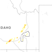
Hail Map for Wednesday, May 24, 2023

Number of Impacted Households on 5/24/2023
0
Impacted by 1" or Larger Hail
0
Impacted by 1.75" or Larger Hail
0
Impacted by 2.5" or Larger Hail
Square Miles of Populated Area Impacted on 5/24/2023
0
Impacted by 1" or Larger Hail
0
Impacted by 1.75" or Larger Hail
0
Impacted by 2.5" or Larger Hail


Cities Most Affected by Hail Storms of 5/24/2023
| Hail Size | Demographics of Zip Codes Affected | ||||||
|---|---|---|---|---|---|---|---|
| City | Count | Average | Largest | Pop Density | House Value | Income | Age |
| Clovis, NM | 5 | 1.90 | 2.00 | 93 | $66k | $28.9k | 31.3 |
| San Jon, NM | 4 | 1.94 | 2.00 | 0 | $35k | $25.5k | 48.2 |
| Burley, ID | 2 | 1.75 | 1.75 | 67 | $82k | $32.2k | 31.8 |
| Heyburn, ID | 2 | 1.75 | 1.75 | 122 | $77k | $33.2k | 35.5 |
| Lame Deer, MT | 1 | 2.75 | 2.75 | 0 | $48k | $23.3k | 23.7 |
| Texico, NM | 1 | 2.05 | 2.05 | 4 | $53k | $27.4k | 31.9 |
| Bard, NM | 1 | 2.00 | 2.00 | 0 | $225k | $20.9k | 50.5 |
| Broadview, NM | 1 | 2.00 | 2.00 | 1 | $40k | $32.0k | 55.2 |
| Rupert, ID | 1 | 1.75 | 1.75 | 41 | $72k | $31.0k | 34.9 |
| Portales, NM | 1 | 1.75 | 1.75 | 28 | $55k | $26.6k | 29.0 |
| Wink, TX | 1 | 1.75 | 1.75 | 0 | $32k | $39.7k | 36.6 |
| Sedan, NM | 1 | 1.75 | 1.75 | 2 | $45k | $31.5k | 43.3 |
| Tyrone, OK | 1 | 1.75 | 1.75 | 3 | $57k | $35.5k | 37.9 |
Hail and Wind Damage Spotted on 5/24/2023
Filter by Report Type:Hail ReportsWind Reports
States Impacted
Florida, Utah, Colorado, Nevada, Kansas, Idaho, Montana, New Mexico, Texas, OklahomaFlorida
| Local Time | Report Details |
|---|---|
| 2:13 PM EDT | A wind gust of 58 mph or 50 kt was recorded at the juno beach pier mesone in amz650 county FL, 31.8 miles SE of Port Saint Lucie, FL |
| 3:54 PM EDT | Metal donation clothing box blown into w c owen avenue in clewiston as a strong thunderstorm moved through the area. radar estimated time of 3:54p in hendry county FL, 50.2 miles SW of Port Saint Lucie, FL |
| 3:59 PM EDT | Ham radio operator passed along a report from a trained weather spotter of a large tree and powerlines down on lantana road just east of the intersection with jog roa in palm beach county FL, 48.9 miles SSE of Port Saint Lucie, FL |
| 4:00 PM EDT | Broadcast meteorologist shared via social media... several trees down on the street as well as fence damage in northern clewiston near ponce de leon avenue. radar estim in hendry county FL, 50.2 miles SW of Port Saint Lucie, FL |
| 4:30 PM EDT | Hendry county em advises of a local storm report in clewiston. caller states that roof damage occurred at clewiston nursing and rehabilitation center due to thunderstor in hendry county FL, 50.7 miles SW of Port Saint Lucie, FL |
| 4:54 PM EDT | Earth networks mesonet bllgl glades central community high school reported a wind gust of 62 mph at 4:54 pm as a severe thunderstorm moved through the are in palm beach county FL, 46 miles SSW of Port Saint Lucie, FL |
Utah
| Local Time | Report Details |
|---|---|
| 12:37 PM MDT | Quarter sized hail reported near , , 40.9 miles NNW of Price, UT |
| 12:37 PM MDT | Quarter sized hail reported near , , 44.7 miles NNW of Price, UT, corrected location |
| 2:20 PM MDT | Half Dollar sized hail reported near Tabiona, UT, 53.3 miles N of Price, UT, public video of multiple hailstones approximately half dollar size. time estimated by radar. |
Colorado
| Local Time | Report Details |
|---|---|
| 1:52 PM MDT | Half Dollar sized hail reported near Parker, CO, 20.3 miles SE of Denver, CO, delayed report. spotter reported dime to half dollar sized hail. time estimated by radar. |
| 2:14 PM MDT | Quarter sized hail reported near Parker, CO, 20.1 miles SE of Denver, CO |
| 3:27 PM MDT | Ping Pong Ball sized hail reported near Pueblo, CO, 14.4 miles SSW of Pueblo, CO |
| 4:10 PM MDT | Quarter sized hail reported near Pueblo, CO, 8.1 miles WNW of Pueblo, CO |
| 4:30 PM MDT | Quarter sized hail reported near Pueblo, CO, 9.9 miles NW of Pueblo, CO |
Nevada
| Local Time | Report Details |
|---|---|
| 1:00 PM PDT | Ping Pong Ball sized hail reported near Spring Creek, NV, 8.1 miles SE of Elko, NV, public report of 1.25 to 1.5 inch hail. |
| 1:40 PM PDT | Ping Pong Ball sized hail reported near Spring Creek, NV, 9.4 miles S of Elko, NV, photo of 1.25 to 1.5 inch hail against ruler. |
| 1:46 PM PDT | Ping Pong Ball sized hail reported near Spring Creek, NV, 9.5 miles S of Elko, NV, public photos of 1.25 to 1.5 inch hail. |
| 2:30 PM PDT | Quarter sized hail reported near Carlin, NV, 27.1 miles WSW of Elko, NV, hail covering i-80 seen from ndot camera at emigrant pass. report from travelers that hail sounded like a shotgun when hitting vehicle. |
Kansas
| Local Time | Report Details |
|---|---|
| 4:17 PM CDT | Quarter sized hail reported near Emporia, KS, 56.1 miles SSE of Manhattan, KS, relayed via kvoe radio. |
| 8:18 PM CDT | Quarter sized hail reported near Liberal, KS, 66.2 miles SSW of Garden City, KS |
| 8:22 PM CDT | Quarter sized hail reported near Liberal, KS, 66.2 miles SSW of Garden City, KS, corrects previous hail report from 10 s woods. time est from radar. |
Idaho
| Local Time | Report Details |
|---|---|
| 3:30 PM MDT | Golf Ball sized hail reported near Heyburn, ID, 36.2 miles E of Twin Falls, ID, corrects previous hail report from heyburn. |
| 3:30 PM MDT | Quarter sized hail reported near Pocatello, ID, 47.6 miles SSW of Idaho Falls, ID |
| 3:30 PM MDT | Golf Ball sized hail reported near Rupert, ID, 37.3 miles E of Twin Falls, ID, extensive wheat and beet crop damage reported due to shredding of vegetation by large hailstones. golf ball hail had been reported in the area as well. |
| 3:36 PM MDT | Golf Ball sized hail reported near Burley, ID, 34.7 miles E of Twin Falls, ID, corrects previous hail report from burley. |
| 3:40 PM MDT | Quarter sized hail reported near Pocatello, ID, 47.5 miles SSW of Idaho Falls, ID |
| 3:52 PM MDT | Quarter sized hail reported near Rupert, ID, 41.6 miles E of Twin Falls, ID |
| 3:55 PM MDT | Golf Ball sized hail reported near Burley, ID, 34.7 miles E of Twin Falls, ID |
| 4:03 PM MDT | Golf Ball sized hail reported near Heyburn, ID, 36.2 miles E of Twin Falls, ID |
| 8:20 PM MDT | Thunderstorm wind snapped irrigation pivot in two. (occurred earlier in bingham county ID, 34 miles WSW of Idaho Falls, ID |
Montana
| Local Time | Report Details |
|---|---|
| 5:11 PM MDT | Baseball sized hail reported near Lame Deer, MT, 66.9 miles SW of Miles City, MT |
| 5:50 PM MDT | Quarter sized hail reported near Hathaway, MT, 18.5 miles WSW of Miles City, MT |
| 6:32 PM MDT | Quarter sized hail reported near Jordan, MT, 78.5 miles NW of Miles City, MT, estimated one inch of rain in 30 minutes. |
| 6:45 PM MDT | Quarter sized hail reported near Miles City, MT, 7.7 miles NNW of Miles City, MT |
New Mexico
| Local Time | Report Details |
|---|---|
| 5:41 PM MDT | Quarter sized hail reported near San Jon, NM, 22.3 miles ESE of Tucumcari, NM, report from mping: quarter (1.00 in.). |
| 5:41 PM MDT | Quarter sized hail reported near San Jon, NM, 21.8 miles ESE of Tucumcari, NM, report from mping: quarter (1.00 in.). |
| 5:42 PM MDT | Asos station ktcc tucumcari muni airpor in quay county NM, 7.1 miles E of Tucumcari, NM |
| 5:45 PM MDT | Ping Pong Ball sized hail reported near Amistad, NM, 56.7 miles NNE of Tucumcari, NM, hail between half inch and ping pong balls lasted around 45 minutes. significant accumulation. |
| 5:54 PM MDT | Hen Egg sized hail reported near San Jon, NM, 19.6 miles E of Tucumcari, NM |
| 5:55 PM MDT | Golf Ball sized hail reported near Sedan, NM, 76.2 miles NNE of Tucumcari, NM |
| 5:57 PM MDT | Golf Ball sized hail reported near San Jon, NM, 19.9 miles ESE of Tucumcari, NM, report from mping: golf ball (1.75 in.). |
| 5:59 PM MDT | Hen Egg sized hail reported near San Jon, NM, 19.9 miles ESE of Tucumcari, NM |
| 6:00 PM MDT | Multiple semi rollovers along i-40. location estimate in quay county NM, 4.3 miles E of Tucumcari, NM |
| 6:15 PM MDT | Hen Egg sized hail reported near San Jon, NM, 19.9 miles ESE of Tucumcari, NM |
| 6:18 PM MDT | Quarter sized hail reported near San Jon, NM, 25 miles ESE of Tucumcari, NM |
| 6:18 PM MDT | Storm damage reported in quay county NM, 25 miles ESE of Tucumcari, NM |
| 6:24 PM MDT | Hen Egg sized hail reported near Bard, NM, 26.1 miles ESE of Tucumcari, NM |
| 6:26 PM MDT | Half Dollar sized hail reported near Bard, NM, 33.3 miles E of Tucumcari, NM |
| 6:30 PM MDT | Storm damage reported in quay county NM, 34.4 miles E of Tucumcari, NM |
| 6:46 PM MDT | Quarter sized hail reported near Bard, NM, 36.5 miles E of Tucumcari, NM |
| 6:52 PM MDT | Quarter sized hail reported near San Jon, NM, 37.9 miles E of Tucumcari, NM |
| 7:10 PM MDT | Northside windows of baptist church knocked ou in curry county NM, 33.7 miles SE of Tucumcari, NM |
| 7:12 PM MDT | Hen Egg sized hail reported near Broadview, NM, 36.1 miles SE of Tucumcari, NM, report from mping: hen egg (2.00 in.). |
| 7:13 PM MDT | Torus mobile mesonet clocked 92.4 mph from rf in curry county NM, 34.1 miles SE of Tucumcari, NM |
| 7:23 PM MDT | Measured with handhel in curry county NM, 47.3 miles SE of Tucumcari, NM |
| 7:47 PM MDT | Storm damage reported in curry county NM, 62.9 miles SSE of Tucumcari, NM |
| 8:00 PM MDT | Golf Ball sized hail reported near Clovis, NM, 50.3 miles SSE of Tucumcari, NM |
| 8:05 PM MDT | Quarter sized hail reported near Clovis, NM, 56.1 miles SSE of Tucumcari, NM |
| 8:10 PM MDT | Golf Ball sized hail reported near Clovis, NM, 58.2 miles SSE of Tucumcari, NM, curry road p and navajo road. |
| 8:14 PM MDT | Half Dollar sized hail reported near Clovis, NM, 59.4 miles SSE of Tucumcari, NM, 21st street and echols. |
| 8:15 PM MDT | Quarter sized hail reported near Clovis, NM, 59.4 miles SSE of Tucumcari, NM, report from mping: quarter (1.00 in.). |
| 8:21 PM MDT | Hen Egg sized hail reported near Clovis, NM, 55.5 miles SSE of Tucumcari, NM, wind driven hail. |
| 8:27 PM MDT | Quarter sized hail reported near Clovis, NM, 57.8 miles SSE of Tucumcari, NM |
| 8:30 PM MDT | Hen Egg sized hail reported near Clovis, NM, 60.8 miles SSE of Tucumcari, NM |
| 8:38 PM MDT | Asos station kcvs cannon air force bas in curry county NM, 60.3 miles SSE of Tucumcari, NM |
| 8:38 PM MDT | Hen Egg sized hail reported near Clovis, NM, 59.6 miles SSE of Tucumcari, NM |
| 8:40 PM MDT | Storm damage reported in curry county NM, 64.2 miles SSE of Tucumcari, NM |
| 8:42 PM MDT | Ping Pong Ball sized hail reported near Texico, NM, 66.5 miles SE of Tucumcari, NM, us 84 and garwood st. |
| 8:43 PM MDT | Quarter sized hail reported near Clovis, NM, 63.4 miles SSE of Tucumcari, NM, report from mping: quarter (1.00 in.). |
| 8:43 PM MDT | Hen Egg sized hail reported near Texico, NM, 63.2 miles SE of Tucumcari, NM, measured with calipers. |
| 9:00 PM MDT | Significant damage to a dairy... including roof damage... door damage and powerlines/power poles down in/around the dair in curry county NM, 63.2 miles SSE of Tucumcari, NM |
| 9:00 PM MDT | Transformer bent over county road 5. multiple tree limbs down as wel in curry county NM, 63.9 miles SSE of Tucumcari, NM |
| 9:00 PM MDT | Wall collapsed on red arrow entertainment building near mitchell and 21st street due to strong wind in curry county NM, 59.9 miles SSE of Tucumcari, NM |
| 9:05 PM MDT | Traffic sign blown down/bent ove in curry county NM, 66.3 miles SSE of Tucumcari, NM |
| 9:09 PM MDT | Report from mping: 1-inch tree limbs broken; shingles blown of in curry county NM, 63.2 miles SSE of Tucumcari, NM |
| 9:30 PM MDT | Report from mping: 1-inch tree limbs broken; shingles blown of in curry county NM, 59.7 miles SSE of Tucumcari, NM |
| 9:35 PM MDT | Golf Ball sized hail reported near Portales, NM, 71.8 miles SSE of Tucumcari, NM, report from mping: golf ball (1.75 in.). |
| 9:38 PM MDT | Ping Pong Ball sized hail reported near Portales, NM, 71.8 miles SSE of Tucumcari, NM, report from mping: ping pong ball (1.50 in.). |
| 9:40 PM MDT | Ping Pong Ball sized hail reported near Portales, NM, 71.1 miles SSE of Tucumcari, NM |
Texas
| Local Time | Report Details |
|---|---|
| 7:18 PM CDT | Golf Ball sized hail reported near , , 47.6 miles WSW of Odessa, TX, spotter relayed report from son of golf ball size hail 7 miles south of wink. |
| 7:31 PM CDT | Golf Ball sized hail reported near Wink, TX, 46.7 miles W of Odessa, TX, winkler co. emc reports golf ball size hail at 113 airport rd in wink. |
| 8:00 PM CDT | Storm damage reported in quay county NM, 38.8 miles E of Tucumcari, NM |
| 9:01 PM CDT | Observed by mesone in deaf smith county TX, 46.2 miles ESE of Tucumcari, NM |
| 9:20 PM CDT | Observed by mesone in potter county TX, 15.6 miles NNW of Amarillo, TX |
| 10:05 PM CDT | West texas mesonet measured several severe gusts between 59 and 64 mph... starting at 9:59 pm and continuing through the current time of 10:05 p in parmer county TX, 61.9 miles SW of Amarillo, TX |
| 10:06 PM CDT | West texas mesonet measured several severe gusts between 59 and 67 mph... starting at 9:59 pm and continuing through 10:09 p in parmer county TX, 61.9 miles SW of Amarillo, TX |
| 11:59 PM CDT | Golf Ball sized hail reported near , , 67.6 miles W of Lubbock, TX, report of golf ball size hail on twitter. |
| 11:59 PM CDT | Ping Pong Ball sized hail reported near , , 67.6 miles W of Lubbock, TX, report of ping pong size golf ball on twitter. |
| 12:35 AM CDT | Delayed report: power poles blown down. community of whitharral reported to be without power. time estimated from rada in hockley county TX, 29.2 miles WNW of Lubbock, TX |
| 12:38 AM CDT | Delayed report: several trees blown down in anton. power was also knocked out for several hours. time estimated from rada in hockley county TX, 23.1 miles NW of Lubbock, TX |
| 12:53 AM CDT | Storm damage reported in hockley county TX, 23.1 miles NW of Lubbock, TX |
| 2:27 AM CDT | West texas mesone in terry county TX, 38.8 miles SW of Lubbock, TX |
| 3:05 AM CDT | Quarter sized hail reported near Plains, TX, 62.8 miles WSW of Lubbock, TX, large quantities of accumulating hail up to quarter size. |
| 3:11 AM CDT | West texas mesone in yoakum county TX, 75.2 miles WSW of Lubbock, TX |
| 3:46 AM CDT | Mesonet station 15 seagraves 1s in gaines county TX, 61.1 miles SW of Lubbock, TX |
Oklahoma
| Local Time | Report Details |
|---|---|
| 8:40 PM CDT | Golf Ball sized hail reported near Tyrone, OK, 70.4 miles S of Garden City, KS, corrects previous hail report from tyrone. estimated report from trained spotter of golf ball sized hail and 45-50 mph winds in tyrone... ok around 8:40 pm. hail lasted |
Connect with Interactive Hail Maps