

Hail Map for Tuesday, April 3, 2018

Number of Impacted Households on 4/3/2018
0
Impacted by 1" or Larger Hail
0
Impacted by 1.75" or Larger Hail
0
Impacted by 2.5" or Larger Hail
Square Miles of Populated Area Impacted on 4/3/2018
0
Impacted by 1" or Larger Hail
0
Impacted by 1.75" or Larger Hail
0
Impacted by 2.5" or Larger Hail


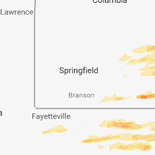


Cities Most Affected by Hail Storms of 4/3/2018
| Hail Size | Demographics of Zip Codes Affected | ||||||
|---|---|---|---|---|---|---|---|
| City | Count | Average | Largest | Pop Density | House Value | Income | Age |
| Poplar Bluff, MO | 2 | 2.50 | 3.00 | 111 | $62k | $27.4k | 39.9 |
| Pangburn, AR | 2 | 2.38 | 2.75 | 34 | $65k | $32.2k | 42.3 |
| Clinton, AR | 2 | 1.75 | 1.75 | 22 | $61k | $24.7k | 44.4 |
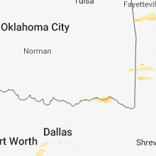
| Mena, AR | 1 | 2.50 | 2.50 | 24 | $61k | $25.4k | 45.5 |
| Lampasas, TX | 1 | 1.75 | 1.75 | 21 | $63k | $34.1k | 41.2 |
| Bonnieville, KY | 1 | 1.75 | 1.75 | 40 | $55k | $26.4k | 41.6 |
| Vincennes, IN | 1 | 1.75 | 1.75 | 152 | $72k | $31.0k | 37.0 |
| Cape Girardeau, MO | 1 | 1.75 | 1.75 | 270 | $101k | $37.9k | 32.9 |
| Melbourne, AR | 1 | 1.75 | 1.75 | 13 | $61k | $24.7k | 43.9 |
| Vine Grove, KY | 1 | 1.75 | 1.75 | 184 | $86k | $38.6k | 36.7 |
| Pottersville, MO | 1 | 1.75 | 1.75 | 15 | $67k | $26.5k | 40.7 |
| Trumann, AR | 1 | 1.75 | 1.75 | 54 | $48k | $27.0k | 38.2 |
| San Antonio, TX | 1 | 1.75 | 1.75 | 3345 | $75k | $46.1k | 30.2 |
| Caulfield, MO | 1 | 1.75 | 1.75 | 14 | $44k | $23.1k | 46.7 |
| Magness, AR | 1 | 1.75 | 1.75 | 0 | $28k | $20.0k | 32.5 |
| Campbellsville, KY | 1 | 1.75 | 1.75 | 99 | $71k | $28.8k | 39.3 |
| Greensburg, KY | 1 | 1.75 | 1.75 | 47 | $53k | $24.2k | 42.9 |
| Alton, MO | 1 | 1.75 | 1.75 | 16 | $42k | $20.4k | 43.9 |
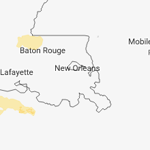
| Leesville, LA | 1 | 1.75 | 1.75 | 40 | $67k | $29.7k | 34.8 |
| Doyle, TN | 1 | 1.75 | 1.75 | 63 | $69k | $29.0k | 41.3 |
| Dexter, MO | 1 | 1.75 | 1.75 | 101 | $66k | $27.7k | 41.8 |
Hail and Wind Damage Spotted on 4/3/2018
Filter by Report Type:Hail ReportsWind Reports
States Impacted
Illinois, Colorado, Texas, Indiana, Alabama, Arkansas, Oklahoma, Ohio, Missouri, Louisiana, Kentucky, Mississippi, Pennsylvania, West Virginia, Tennessee, Georgia, VirginiaIllinois
| Local Time | Report Details |
|---|---|
| 8:47 AM CDT | Quarter sized hail reported near Charleston, IL, 10.5 miles E of Mattoon, IL |
| 4:55 PM CDT | Quarter sized hail reported near Du Quoin, IL, 49.8 miles NNE of Cape Girardeau, MO |
| 4:55 PM CDT | Storm damage reported in perry county IL, 50.9 miles NNE of Cape Girardeau, MO |
| 5:20 PM CDT | Late report. trees down and metal roof peeled bac in williamson county IL, 40.7 miles NE of Cape Girardeau, MO |
| 5:25 PM CDT | Late report. multiple structures damaged. relayed via fire/rescue vide in williamson county IL, 43.4 miles NE of Cape Girardeau, MO |
| 5:25 PM CDT | Late report. multiple structures damaged. relayed via fire/rescue vide in williamson county IL, 43.4 miles NE of Cape Girardeau, MO |
| 5:45 PM CDT | Tree blocking roa in williamson county IL, 43.4 miles NE of Cape Girardeau, MO |
| 5:53 PM CDT | Quarter sized hail reported near Ullin, IL, 20.1 miles E of Cape Girardeau, MO, reported along interstate 57 |
| 7:05 PM CDT | Time unknown...399 customers lost power throughout the count in williamson county IL, 44.4 miles NE of Cape Girardeau, MO |
| 7:49 PM CDT | Quarter sized hail reported near Galatia, IL, 57.9 miles W of Evansville, IN |
Colorado
| Local Time | Report Details |
|---|---|
| 9:10 AM MDT | Peak gust for the da in cheyenne county CO, 89.9 miles ENE of Pueblo, CO |
Texas
| Local Time | Report Details |
|---|---|
| 10:27 AM CDT | Quarter sized hail reported near Kempner, TX, 20.6 miles W of Killeen, TX, quarter size on fm 580 |
| 10:54 AM CDT | Quarter sized hail reported near Tow, TX, 45.9 miles WSW of Killeen, TX, quarter size hail reported at hi-line lake resort. |
| 10:54 AM CDT | Half Dollar sized hail reported near Tow, TX, 47.3 miles WSW of Killeen, TX, photo of half dollar sized hail at texas hills rv haven in tow. |
| 10:58 AM CDT | Quarter sized hail reported near Tow, TX, 46.8 miles WSW of Killeen, TX, emergency manager reports quarter sized hail in the tow area. |
| 11:10 AM CDT | Ping Pong Ball sized hail reported near Lampasas, TX, 31.3 miles WSW of Killeen, TX, report of hailstones up to ping pong balls at c&w ranch in northern burnet county west of us 281. |
| 11:17 AM CDT | Ping Pong Ball sized hail reported near Lampasas, TX, 27.3 miles WSW of Killeen, TX, ping pong ball sized hail near the intersection of county roads 206 and 207 in northern burnet county. |
| 11:30 AM CDT | Golf Ball sized hail reported near Lampasas, TX, 27 miles W of Killeen, TX, picture sent of golf ball sized hail off the north end of the airport runway at klzz. |
| 12:51 PM CDT | Quarter sized hail reported near Thornton, TX, 71.8 miles ENE of Killeen, TX, spotter reports quarter size hail at county road 758 1 mile east of thornton. |
| 1:09 PM CDT | Quarter sized hail reported near Temple, TX, 22.4 miles E of Killeen, TX, quarter size hail reported in temple. |
| 2:25 PM CDT | Power line down on hwy 323 outside of overton in nw rus in rusk county TX, 66.3 miles NNW of Lufkin, TX |
| 2:30 PM CDT | Quarter sized hail reported near Jacksonville, TX, 45.5 miles NNW of Lufkin, TX, public reports quarter size hail near lake striker via broadcast media. |
| 2:50 PM CDT | Fire dept battling blaze on cr 401 off fm 839 due to lightning strike on tank battery fire... 3 other tanks threatened by the flame in rusk county TX, 56.5 miles N of Lufkin, TX |
| 3:30 PM CDT | Quarter sized hail reported near Mount Enterprise, TX, 39.3 miles N of Lufkin, TX, quarter size hail fell off of highway 84 west of mount enterprise. |
| 3:40 PM CDT | Large tree down in yard on main street per kytx social medi in nacogdoches county TX, 36.2 miles NNE of Lufkin, TX |
| 3:48 PM CDT | Trees down and trees reported down on homes in east wasko in harrison county TX, 18.4 miles W of Shreveport, LA |
| 3:49 PM CDT | Corrects previous tstm wnd dmg report from 2 e cushing. trees down sh 204 east of cushin in nacogdoches county TX, 32.7 miles N of Lufkin, TX |
| 3:58 PM CDT | Trees down hwy 59 north near the sabine rive in panola county TX, 38.2 miles WSW of Shreveport, LA |
| 4:08 PM CDT | Reports of trees down and roofs off buildings near the squar in nacogdoches county TX, 36.2 miles NNE of Lufkin, TX |
| 4:12 PM CDT | Tree down on hwy 84 in logansport... power line down on hwy 76 in de soto county LA, 40.6 miles SSW of Shreveport, LA |
| 5:03 PM CDT | Trees and power lines down on cr 3291 off fm 95 near garriso in rusk county TX, 37.1 miles NNE of Lufkin, TX |
| 5:36 PM CDT | Quarter sized hail reported near Mexia, TX, 80.1 miles ENE of Killeen, TX, on lcr 456 5 miles south of mexia |
| 8:53 PM CDT | Quarter sized hail reported near Burkeville, TX, 62.6 miles N of Beaumont, TX, public reported quarter sized hail in burkeville. time estimated from radar. |
| 9:20 PM CDT | Quarter sized hail reported near San Antonio, TX, 8.2 miles E of San Antonio, TX, quarter sized hail between kirby and china grove reported by public. |
| 9:25 PM CDT | Golf Ball sized hail reported near San Antonio, TX, 8.3 miles ENE of San Antonio, TX, quarter to golfball sized hail. |
| 9:45 PM CDT | Quarter sized hail reported near La Vernia, TX, 21.8 miles ESE of San Antonio, TX, quarter sized hail reported from pizzahut on us highway87 and fm 1346. |
| 9:51 PM CDT | Half Dollar sized hail reported near La Vernia, TX, 26.1 miles ESE of San Antonio, TX |
| 11:52 PM CDT | Hanger at hobby airport damaged along with aircraft. pilots trapped in jet aviation damaged building on the east side of the airpor in harris county TX, 10.9 miles SE of Houston, TX |
| 11:56 PM CDT | Khou houston hobby airport asos measured 52 knot wind gus in harris county TX, 9.3 miles SE of Houston, TX |
Indiana
| Local Time | Report Details |
|---|---|
| 11:37 AM EDT | Quarter sized hail reported near Stilesville, IN, 29 miles WSW of Indianapolis, IN |
| 12:52 PM EDT | Quarter sized hail reported near Rockville, IN, 50.6 miles W of Indianapolis, IN, most were the size of nickels with a few slightly larger than a quarter. |
| 1:37 PM EDT | Quarter sized hail reported near Vincennes, IN, 49.2 miles N of Evansville, IN, hail a bit bigger than quarters. |
| 1:40 PM EDT | Ping Pong Ball sized hail reported near Vincennes, IN, 48.5 miles N of Evansville, IN, time approximate. |
| 1:45 PM EDT | Golf Ball sized hail reported near Vincennes, IN, 48.5 miles N of Evansville, IN, approximate location (given as smith and scott). |
| 1:45 PM EDT | Quarter sized hail reported near Vincennes, IN, 48.6 miles N of Evansville, IN, size was slightly bigger than 1 inch. approximate location. delayed report. |
| 2:15 PM EDT | Tree down near intersection of bland road and camp branch road of unknown siz in greene county IN, 58.7 miles SW of Indianapolis, IN |
| 4:33 PM EDT | Time estimated by rada in jefferson county IN, 52.4 miles WSW of Cincinnati, OH |
| 3:35 PM CDT | Half Dollar sized hail reported near Grovertown, IN, 68.2 miles ESE of Chicago, IL |
| 4:49 PM EDT | Half Dollar sized hail reported near Plymouth, IN, 71.6 miles WNW of Fort Wayne, IN, received via social media. |
| 7:05 PM EDT | Corrects previous tstm wnd dmg report from lafayette. multiple mature trees down in lafayette across 9th street near old downtown distric in tippecanoe county IN, 58.5 miles NW of Indianapolis, IN |
| 7:15 PM EDT | Approximate location. location is cr750e and cr400n. high winds... some tree limb debris... stop signs blowin in tippecanoe county IN, 53.7 miles NW of Indianapolis, IN |
| 7:35 PM EDT | Estimate reported as 60 plus mph. time is approximat in sullivan county IN, 59.1 miles ESE of Mattoon, IL |
| 7:40 PM EDT | Time estimated. grain bin of approximately 30 feet tall by 30 feet wide had its top blown off and the bin was moved off its foundation. located at 400 east and 400 sout in clinton county IN, 34.8 miles NNW of Indianapolis, IN |
| 7:46 PM EDT | Approximate location and time. tree damage and minor roof damage to structures near jasonvill in greene county IN, 66.8 miles ESE of Mattoon, IL |
| 7:47 PM EDT | Tree blocking roa in sullivan county IN, 65.3 miles ESE of Mattoon, IL |
| 7:47 PM EDT | Trees and power lines down and camper turned over. relayed by dispatch. time estimated by rada in clay county IN, 66.1 miles ESE of Mattoon, IL |
| 7:50 PM EDT | Shed destroyed with person inside... though not injured. glider was taken off porc in harrison county IN, 16.9 miles NW of Louisville, KY |
| 8:54 PM EDT | Storm damage reported in hancock county IN, 17.8 miles ENE of Indianapolis, IN |
Alabama
| Local Time | Report Details |
|---|---|
| 11:42 AM CDT | Em reports power lines down on tabor road. time estimated by rada in etowah county AL, 64.5 miles NE of Birmingham, AL |
| 9:20 PM CDT | Lauderdale ema reports trees and utility lines down near waterloo. time est. by rada in lauderdale county AL, 23.4 miles WNW of Florence, AL |
| 9:35 PM CDT | Trees down along natchez trace pkwy near hwy 2 in lauderdale county AL, 12.9 miles NW of Florence, AL |
| 9:40 PM CDT | Em reports trees down in shottsville community near cr 126 and colburn road. time estimated by rada in marion county AL, 42.4 miles SSW of Florence, AL |
| 9:40 PM CDT | Colbert ema reports trees and powerlines down near ligon springs are in colbert county AL, 15 miles SSW of Florence, AL |
| 9:42 PM CDT | Trees down blocking road near colbert heights are in colbert county AL, 9.1 miles S of Florence, AL |
| 9:42 PM CDT | Em relayed reports from 911 of trees down in shiloh community near county roads 73 and 20. time estimated by rada in marion county AL, 41.5 miles SSW of Florence, AL |
| 9:46 PM CDT | Kmsl reported a gust to 54 kt (62mph in colbert county AL, 5.1 miles SE of Florence, AL |
| 9:46 PM CDT | Large tree down on tuxedo av in colbert county AL, 4.2 miles S of Florence, AL |
| 9:47 PM CDT | Em reports trees down on cr 27 south of hwy 43 in guin. time estimated by rada in marion county AL, 59.7 miles S of Florence, AL |
| 9:50 PM CDT | Numerous reports of trees down in the florence are in lauderdale county AL, 2 miles NE of Florence, AL |
| 9:54 PM CDT | Em reports trees down in whitehouse community near state hwy 241 and 278. time estimated on rada in marion county AL, 46.4 miles S of Florence, AL |
| 9:54 PM CDT | Reports of trees down on newburg rd in haleyville. time estimated by rada in winston county AL, 38.8 miles S of Florence, AL |
| 10:10 PM CDT | Tree down on vehicle near al 157/3 in lawrence county AL, 28.8 miles SE of Florence, AL |
| 10:11 PM CDT | Trees down in roadway along lee st. near rogersvill in lauderdale county AL, 22.5 miles E of Florence, AL |
| 10:15 PM CDT | Trees down along cr 249/25 in lawrence county AL, 27.3 miles ESE of Florence, AL |
| 10:29 PM CDT | Kdcu reports a wind gust of 63 kt (72mph in morgan county AL, 50.3 miles ESE of Florence, AL |
| 10:33 PM CDT | Rm young anemometer on the university of alabama huntsville max radar unit recorded a 67 mph wind gust at exit 347 off of interstate 65 in limestone count in limestone county AL, 42.1 miles E of Florence, AL |
| 10:34 PM CDT | Damage to sears building in parkland shopping center. time estimated by rada in walker county AL, 35.3 miles NW of Birmingham, AL |
| 10:39 PM CDT | Khsv reports a wind gust to 61 kt (70mph in madison county AL, 52.3 miles ESE of Florence, AL |
| 10:40 PM CDT | Several reports of trees down in and around decatur. tree on house near 8th ave s in morgan county AL, 42.5 miles ESE of Florence, AL |
| 10:40 PM CDT | Damage reported at the river walk marina in decatu in limestone county AL, 42 miles ESE of Florence, AL |
| 10:45 PM CDT | Trees down along california st./locust ave in east huntsvill in madison county AL, 63.1 miles E of Florence, AL |
| 10:45 PM CDT | Media reports trees down on mountain view road in arg in st. clair county AL, 24.4 miles NE of Birmingham, AL |
| 10:48 PM CDT | Reports of trees down on old bankhead hwy. time estimated by rada in walker county AL, 26.2 miles NW of Birmingham, AL |
| 11:00 PM CDT | Trees knocked down and damaged an apartment complex in s. huntsville near golf r in madison county AL, 62.9 miles E of Florence, AL |
| 11:18 PM CDT | Em reports power lines down on briarwood rd in blountsvill in blount county AL, 41.3 miles NNE of Birmingham, AL |
| 11:18 PM CDT | Em reports trees down on rainbow drive at 759 overpass. time estimated by rada in etowah county AL, 56.8 miles NE of Birmingham, AL |
| 11:18 PM CDT | Em reports tree down on old compton rd. time estimated by rada in blount county AL, 20.4 miles NNE of Birmingham, AL |
| 11:20 PM CDT | Trees down along cr 1 near paint roc in jackson county AL, 60.9 miles WSW of Chattanooga, TN |
| 11:22 PM CDT | A metal carport at holy smokes bbq was flipped onto the roof of an adjacent building along veterans drive in scottsboro. additionally... a nearby the storage building/s in jackson county AL, 48 miles WSW of Chattanooga, TN |
| 11:22 PM CDT | Partial damage to the roof and adjacent carport awning occurred at a chevron gas station along hwy 72 in the five points area of scottsbor in jackson county AL, 47.5 miles WSW of Chattanooga, TN |
| 11:24 PM CDT | Tree down on power lines near intersection of cr 17 and cr 2 in jackson county AL, 53.7 miles WSW of Chattanooga, TN |
| 11:28 PM CDT | Tree down on a house near east of scottsbor in jackson county AL, 48 miles WSW of Chattanooga, TN |
| 11:36 PM CDT | Reports from em of broken power poles and multiple trees down on hwy 431 and coal ridge road. time estimated by rada in etowah county AL, 59 miles NE of Birmingham, AL |
| 11:42 PM CDT | Corrects previous tstm wnd dmg report from gadsden mall. em reports trees down on rainbow drive at 759 overpass. time estimated by rada in etowah county AL, 56.8 miles NE of Birmingham, AL |
| 11:48 PM CDT | Em reports trees blocking road near 5810 scenic highway. time estimated by rada in etowah county AL, 64.1 miles NE of Birmingham, AL |
| 11:48 PM CDT | Em reports trees down on 431 in etowah count in etowah county AL, 56.8 miles NE of Birmingham, AL |
| 11:50 PM CDT | Em reports tree blocking road near mile marker 9 on lay springs roa in etowah county AL, 67.2 miles NE of Birmingham, AL |
| 11:50 PM CDT | Em reports trees and power lines down on pope road. time estimated by rada in etowah county AL, 62.2 miles NE of Birmingham, AL |
| 11:54 PM CDT | Power line down on cr97 in pine ridg in dekalb county AL, 48.2 miles SSW of Chattanooga, TN |
| 12:00 AM CDT | *** 1 inj *** em reports tree on house with 1 injury. time estimated by rada in cherokee county AL, 65.2 miles SSW of Chattanooga, TN |
| 12:12 AM CDT | Tree down in roadway along rocky ford point road near cedar bluf in cherokee county AL, 58.9 miles SSW of Chattanooga, TN |
| 12:40 AM CDT | Em reports power lines down at intersection of cedar springs road and post oak roa in calhoun county AL, 59.2 miles ENE of Birmingham, AL |
Arkansas
| Local Time | Report Details |
|---|---|
| 2:24 PM CDT | Quarter sized hail reported near Ozark, AR, 34.6 miles ENE of Fort Smith, AR, mping report |
| 3:13 PM CDT | Tennis Ball sized hail reported near Mena, AR, 49 miles NNW of Nashville, AR |
| 3:22 PM CDT | Quarter sized hail reported near Sidney, AR, 93 miles NNE of Little Rock, AR |
| 3:53 PM CDT | Golf Ball sized hail reported near Melbourne, AR, 87 miles N of Little Rock, AR |
| 4:01 PM CDT | Half Dollar sized hail reported near Melbourne, AR, 92.8 miles NNE of Little Rock, AR |
| 4:05 PM CDT | Quarter sized hail reported near Melbourne, AR, 92.8 miles NNE of Little Rock, AR |
| 4:15 PM CDT | Quarter sized hail reported near Pleasant Plains, AR, 66.2 miles NNE of Little Rock, AR |
| 4:16 PM CDT | Quarter sized hail reported near Clinton, AR, 62.5 miles NNW of Little Rock, AR |
| 4:16 PM CDT | Golf Ball sized hail reported near Clinton, AR, 64.9 miles NNW of Little Rock, AR |
| 4:16 PM CDT | Golf Ball sized hail reported near Clinton, AR, 67 miles NNW of Little Rock, AR |
| 4:22 PM CDT | Quarter sized hail reported near Sidney, AR, 93 miles NNE of Little Rock, AR |
| 4:31 PM CDT | Quarter sized hail reported near Cave City, AR, 92.4 miles NNE of Little Rock, AR |
| 4:48 PM CDT | A tree was blown into an outbuilding. the roof of a barn was lifted... but not blown off. the tops of several trees were snapped. the damage survey was performed by mon in montgomery county AR, 35.5 miles NE of Nashville, AR |
| 4:49 PM CDT | Quarter sized hail reported near Bryant, AR, 14.7 miles SW of Little Rock, AR |
| 4:50 PM CDT | Quarter sized hail reported near Lonoke, AR, 17.7 miles ENE of Little Rock, AR, nickel to quarter sized hail fell. |
| 5:00 PM CDT | Quarter sized hail reported near Strawberry, AR, 91.2 miles NW of Memphis, TN |
| 5:06 PM CDT | Half Dollar sized hail reported near Batesville, AR, 75.3 miles NNE of Little Rock, AR |
| 5:13 PM CDT | Golf Ball sized hail reported near Magness, AR, 79.5 miles NE of Little Rock, AR |
| 5:13 PM CDT | A tree was blown down on airport roa in garland county AR, 47.4 miles WSW of Little Rock, AR |
| 5:15 PM CDT | Quarter sized hail reported near Carlisle, AR, 29.9 miles E of Little Rock, AR |
| 5:20 PM CDT | Quarter sized hail reported near Beech Grove, AR, 74.7 miles NNW of Memphis, TN |
| 5:24 PM CDT | Baseball sized hail reported near Pangburn, AR, 55.5 miles NNE of Little Rock, AR |
| 5:25 PM CDT | Hen Egg sized hail reported near Pangburn, AR, 53 miles NNE of Little Rock, AR |
| 5:28 PM CDT | Quarter sized hail reported near Hazen, AR, 40.2 miles E of Little Rock, AR |
| 5:29 PM CDT | Storm damage reported in jackson county AR, 75 miles WNW of Memphis, TN |
| 5:38 PM CDT | Shed flippe in union county AR, 34.5 miles NW of Bastrop, LA |
| 5:40 PM CDT | Half Dollar sized hail reported near Paragould, AR, 67.9 miles NNW of Memphis, TN |
| 5:40 PM CDT | Ping Pong Ball sized hail reported near Paragould, AR, 67.9 miles NNW of Memphis, TN |
| 5:40 PM CDT | Power poles leaning on highway 6 in greene county AR, 67.9 miles NNW of Memphis, TN |
| 5:53 PM CDT | Half Dollar sized hail reported near De Valls Bluff, AR, 46.4 miles E of Little Rock, AR |
| 5:55 PM CDT | Quarter sized hail reported near Jonesboro, AR, 58.7 miles NW of Memphis, TN, hail falling on the southwest side of town. |
| 6:00 PM CDT | Trees down in north crosset in ashley county AR, 27 miles N of Bastrop, LA |
| 6:09 PM CDT | Quarter sized hail reported near Mc Crory, AR, 63.6 miles WNW of Memphis, TN |
| 6:10 PM CDT | Carport damag in craighead county AR, 49.9 miles NW of Memphis, TN |
| 6:15 PM CDT | Large tree falls on car in crosset in ashley county AR, 24.4 miles N of Bastrop, LA |
| 6:15 PM CDT | Quarter sized hail reported near Trumann, AR, 44.6 miles NW of Memphis, TN, winds estimated at 40 to 45mph with higher gusts. |
| 6:15 PM CDT | Golf Ball sized hail reported near Trumann, AR, 44.6 miles NW of Memphis, TN, hail ranged from pea to golfball size across town. |
| 6:15 PM CDT | Wide spread trees and power lines down across the count in ashley county AR, 27.6 miles NNE of Bastrop, LA |
| 6:23 PM CDT | Trees down in parkdal in ashley county AR, 31.7 miles NE of Bastrop, LA |
| 6:34 PM CDT | Power poles down along bill young r in chicot county AR, 44.9 miles NE of Bastrop, LA |
| 6:35 PM CDT | Power lines down along highway 61 near the state lin in mississippi county AR, 58.4 miles N of Memphis, TN |
| 6:43 PM CDT | There are reports of stoplights... trees... and power lines down in lake villag in chicot county AR, 52.5 miles NE of Bastrop, LA |
| 6:43 PM CDT | Power pole snapped along highway 6 in chicot county AR, 53.6 miles NE of Bastrop, LA |
| 6:45 PM CDT | Tree down across county road 679 just south of tow in mississippi county AR, 52.9 miles N of Memphis, TN |
| 6:45 PM CDT | Approximately 30 power poles and multiple trees downed and snapped from lake village down to the greenville bridge. most of the area is without powe in chicot county AR, 51.4 miles NE of Bastrop, LA |
Oklahoma
| Local Time | Report Details |
|---|---|
| 2:35 PM CDT | Quarter sized hail reported near Battiest, OK, 68.4 miles E of Atoka, OK, retired co-op observer reports quarter size hail in battiest. |
Ohio
| Local Time | Report Details |
|---|---|
| 3:35 PM EDT | Large tree and power lines down on 732 near hueston woods state park. time estimated from rada in preble county OH, 35.4 miles NNW of Cincinnati, OH |
| 3:53 PM EDT | Quarter sized hail reported near Camden, OH, 37.6 miles NNW of Cincinnati, OH |
| 3:56 PM EDT | Half Dollar sized hail reported near West Alexandria, OH, 44.5 miles N of Cincinnati, OH, between a quarter and half dollar. |
| 4:13 PM EDT | Ping Pong Ball sized hail reported near New Lebanon, OH, 44.8 miles N of Cincinnati, OH, also spotted rotating wall cloud |
| 4:20 PM EDT | Large debris over 741 north of dayton mall. time estimated from rada in montgomery county OH, 40.5 miles NNE of Cincinnati, OH |
| 4:27 PM EDT | Large branches downe in montgomery county OH, 54.2 miles NNE of Cincinnati, OH |
| 4:40 PM EDT | Trees and fence down on krepps road. time estimated from rada in greene county OH, 46.9 miles NE of Cincinnati, OH |
| 4:42 PM EDT | Two houses with structual damage. barn damage in greene county OH, 51.9 miles WSW of Columbus, OH |
| 4:45 PM EDT | Numerous trees down near the intersection of us 68 and route 235 in greene county OH, 52.1 miles WSW of Columbus, OH |
| 5:31 PM EDT | Ping Pong Ball sized hail reported near Grove City, OH, 9.1 miles SSW of Columbus, OH, time estimated from radar. |
| 5:37 PM EDT | Multiple utility poles down in franklin county OH, 7.3 miles SSW of Columbus, OH |
| 5:38 PM EDT | Significant roof and chimney damage. time estimated based on rada in franklin county OH, 1.8 miles E of Columbus, OH |
| 5:43 PM EDT | Half Dollar sized hail reported near Grove City, OH, 9.6 miles SSW of Columbus, OH, photo verified. |
| 5:47 PM EDT | Quarter sized hail reported near Groveport, OH, 10.1 miles SE of Columbus, OH |
| 5:59 PM EDT | Quarter sized hail reported near Baltimore, OH, 22.3 miles ESE of Columbus, OH |
| 6:05 PM EDT | Trees down countywid in fairfield county OH, 27.2 miles SE of Columbus, OH |
| 6:30 PM EDT | Dispatcher states multiple trees and powerlines down in the area in perry county OH, 50.3 miles ESE of Columbus, OH |
| 6:35 PM EDT | Mobile home on ridenour road off sr 13 lifted off its foundation and shifted 3 to 4 feet. trailer on same road shifted. camper on same property as trailer picked up and in perry county OH, 31.3 miles E of Columbus, OH |
| 6:42 PM EDT | Quarter sized hail reported near Blue Rock, OH, 60.1 miles E of Columbus, OH |
| 6:46 PM EDT | Quarter sized hail reported near Mcconnelsville, OH, 62.9 miles ESE of Columbus, OH, right along the morgan/muskingum county line... relayed via broadcast media |
| 6:57 PM EDT | Trees down in guernsey county OH, 79.4 miles E of Columbus, OH |
| 7:03 PM EDT | Quarter sized hail reported near Manchester, OH, 56.1 miles ESE of Cincinnati, OH |
| 7:40 PM EDT | Multiple trees down in and around bethesda in belmont county OH, 63.6 miles WSW of Pittsburgh, PA |
| 8:06 PM EDT | Quarter sized hail reported near Oak Hill, OH, 63.1 miles NW of Charleston, WV |
| 8:09 PM EDT | Couple trees down in the oak hill area in jackson county OH, 63.1 miles NW of Charleston, WV |
| 8:25 PM EDT | Quarter sized hail reported near Bidwell, OH, 53.1 miles NW of Charleston, WV |
Missouri
| Local Time | Report Details |
|---|---|
| 2:37 PM CDT | Quarter sized hail reported near Salem, MO, 12.4 miles E of Salem, MO, delayed report-quarter size hail report via social media video. time estimated via radar. |
| 2:47 PM CDT | Quarter sized hail reported near Viburnum, MO, 23 miles ENE of Salem, MO, delayed report from social media. time estimated from radar. |
| 2:48 PM CDT | Quarter sized hail reported near Potosi, MO, 46.3 miles ENE of Salem, MO, 0.75 miles north of potosi on highway 21. |
| 2:49 PM CDT | Quarter sized hail reported near Potosi, MO, 46 miles ENE of Salem, MO |
| 2:53 PM CDT | Golf Ball sized hail reported near Caulfield, MO, 73.7 miles ESE of Springfield, MO, cloud 9 ranch. |
| 3:02 PM CDT | Golf Ball sized hail reported near Pottersville, MO, 70.1 miles SSW of Salem, MO |
| 3:07 PM CDT | Quarter sized hail reported near Bonne Terre, MO, 52.4 miles SSW of Saint Louis, MO, corrects previous hail report from bonne terre. photo posted to social media. time estimated from radar. |
| 3:07 PM CDT | Half Dollar sized hail reported near Bonne Terre, MO, 52.4 miles SSW of Saint Louis, MO, corrects previous hail report from bonne terre. hail larger than quarters. photo posted to social media. time estimated from radar. |
| 3:10 PM CDT | Quarter sized hail reported near Pomona, MO, 57 miles SSW of Salem, MO |
| 3:11 PM CDT | Quarter sized hail reported near West Plains, MO, 69 miles SSW of Salem, MO |
| 3:14 PM CDT | Quarter sized hail reported near Belleview, MO, 34.4 miles E of Salem, MO, delayed report on twitter. central iron county south of council bluff lake. location approximate. time estimated from radar. |
| 3:21 PM CDT | Ping Pong Ball sized hail reported near Centerville, MO, 34.4 miles ESE of Salem, MO, delayed report with photo on social media. time estimated from radar. |
| 3:49 PM CDT | Golf Ball sized hail reported near Alton, MO, 60.8 miles S of Salem, MO, social media picture of golf ball size hail north of alton and west-southwest of greer. |
| 3:50 PM CDT | Quarter sized hail reported near Alton, MO, 61.1 miles S of Salem, MO |
| 4:00 PM CDT | Quarter sized hail reported near Ironton, MO, 49.2 miles E of Salem, MO |
| 4:25 PM CDT | Quarter sized hail reported near Doniphan, MO, 80.5 miles SSE of Salem, MO, late report. quarter size hail reported in the community. |
| 4:30 PM CDT | Quarter sized hail reported near Ellsinore, MO, 62.7 miles SE of Salem, MO, reported west of ellsinore. |
| 4:53 PM CDT | Hen Egg sized hail reported near Poplar Bluff, MO, 63.8 miles SW of Cape Girardeau, MO |
| 4:55 PM CDT | Ping Pong Ball sized hail reported near Poplar Bluff, MO, 60.7 miles SW of Cape Girardeau, MO, ping pong hail reported in the community |
| 4:55 PM CDT | Tea Cup sized hail reported near Poplar Bluff, MO, 60.7 miles SW of Cape Girardeau, MO, reported by media photo from public. |
| 5:07 PM CDT | Power outages reported throughout the count in wayne county MO, 51.3 miles WSW of Cape Girardeau, MO |
| 5:10 PM CDT | Golf Ball sized hail reported near Cape Girardeau, MO, 0.6 miles NNW of Cape Girardeau, MO, golfball size hail reported in the communtiy of allenville. |
| 5:25 PM CDT | Quarter sized hail reported near Scott City, MO, 6 miles SSE of Cape Girardeau, MO |
| 5:29 PM CDT | Reported at the cape girardeau regional airport which sets in scott county missouri. one quarter mile visibility reported with this stor in scott county MO, 4.3 miles S of Cape Girardeau, MO |
| 5:34 PM CDT | Quarter sized hail reported near Dexter, MO, 42.2 miles SSW of Cape Girardeau, MO, quarter size hail reported. |
| 5:40 PM CDT | Half Dollar sized hail reported near Dexter, MO, 42.2 miles SSW of Cape Girardeau, MO, half dollar size hail report |
| 5:48 PM CDT | Quarter sized hail reported near Dexter, MO, 39.2 miles SSW of Cape Girardeau, MO |
| 5:50 PM CDT | Golf Ball sized hail reported near Dexter, MO, 42.2 miles SSW of Cape Girardeau, MO, golf ball size hail reported. |
| 6:10 PM CDT | Utility pole snapped along highway k near hornersville. possible tornad in dunklin county MO, 60.3 miles N of Memphis, TN |
| 6:24 PM CDT | Two structures down as well as power poles along cr820 in new madrid county MO, 35.4 miles S of Cape Girardeau, MO |
| 6:30 PM CDT | Three farm sheds damaged on dunklin county road 657 just west of town. possible tornad in dunklin county MO, 60.9 miles N of Memphis, TN |
Louisiana
| Local Time | Report Details |
|---|---|
| 3:40 PM CDT | Large carport down per ktbs facebook pos in caddo county LA, 14 miles WSW of Shreveport, LA |
| 3:50 PM CDT | Large tree down in highland neighborhood per ksla social medi in caddo county LA, 1.7 miles SSE of Shreveport, LA |
| 3:50 PM CDT | Large tree down across old mooringsport roa in caddo county LA, 9.3 miles NW of Shreveport, LA |
| 3:55 PM CDT | Transformer blows sparking fire outside royal inn on north market stree in caddo county LA, 0.4 miles NNW of Shreveport, LA |
| 3:55 PM CDT | Tree and power lines down on anna street in shrevepor in caddo county LA, 1.9 miles W of Shreveport, LA |
| 4:10 PM CDT | Large tree down on a vehicle in a driveway per ksla social medi in bossier county LA, 13.9 miles E of Shreveport, LA |
| 4:12 PM CDT | Large tree on hwy 157 in princeto in bossier county LA, 14.8 miles ENE of Shreveport, LA |
| 4:22 PM CDT | Quarter sized hail reported near Shreveport, LA, 9.5 miles SSE of Shreveport, LA, nickel to quarter size hail reported ellerbe estates south shreveport. |
| 4:30 PM CDT | Metal carport destroyed in dixie in in webster county LA, 24.9 miles ENE of Shreveport, LA |
| 4:34 PM CDT | Large tree uprooted and fell on home in north minden per ksla facebook pos in webster county LA, 28.2 miles ENE of Shreveport, LA |
| 5:30 PM CDT | Corrects previous tstm wnd dmg report from hodge. trees down in hodge and power ou in jackson county LA, 58.7 miles SW of Bastrop, LA |
| 5:30 PM CDT | Corrects previous tstm wnd dmg report from hodge. trees down in hodge and power ou in jackson county LA, 58.7 miles SW of Bastrop, LA |
| 5:30 PM CDT | Large pine tree down on home on brooks lan in sabine county LA, 69.9 miles E of Lufkin, TX |
| 5:55 PM CDT | Trees down near exit 107 off of interstate 2 in ouachita county LA, 27.3 miles SW of Bastrop, LA |
| 6:11 PM CDT | A utility pole was broken near the bastrop airpor in morehouse county LA, 1.6 miles ESE of Bastrop, LA |
| 6:11 PM CDT | Utility pole was broken along us 16 in morehouse county LA, 2.7 miles ESE of Bastrop, LA |
| 6:13 PM CDT | A wire was downed along yeldell r in morehouse county LA, 7.9 miles NE of Bastrop, LA |
| 6:15 PM CDT | Down tree on an electrical lin in grant county LA, 75.6 miles SE of Shreveport, LA |
| 6:15 PM CDT | Trees down in northern morehouse parish along hwy 591 (old berlin rd). reported via social medi in morehouse county LA, 11.3 miles NE of Bastrop, LA |
| 6:18 PM CDT | 60 mph wind gust estimated in luna... l in ouachita county LA, 29.7 miles SSW of Bastrop, LA |
| 6:20 PM CDT | Several power lines and trees dow in morehouse county LA, 1 miles WSW of Bastrop, LA |
| 6:20 PM CDT | Corrects previous tstm wnd gst report from monroe regional airport. asos station mlu... monroe regional airport; 3 gusts measured at 1820... 1822... and 182 in ouachita county LA, 19.2 miles SSW of Bastrop, LA |
| 6:20 PM CDT | Corrects previous tstm wnd gst report from monroe regional airport. asos station mlu... monroe regional airport; 3 gusts measured at 1820... 1822... and 182 in ouachita county LA, 19.2 miles SSW of Bastrop, LA |
| 6:31 PM CDT | Traffic signal was blown down at la 15 and la 13 in richland county LA, 27.5 miles S of Bastrop, LA |
| 6:40 PM CDT | A wire was downed along lynn cemetery rd in archibal in richland county LA, 30.5 miles SSE of Bastrop, LA |
| 6:44 PM CDT | A utility pole was broken along vaughan s in west carroll county LA, 28.9 miles E of Bastrop, LA |
| 6:53 PM CDT | Power lines down along hwy 57 in west carroll county LA, 27.9 miles ESE of Bastrop, LA |
| 6:54 PM CDT | A wire was downed along highland d in east carroll county LA, 40.8 miles E of Bastrop, LA |
| 6:55 PM CDT | Utility wire downed in the vicinity of ferguson rd and cooper rd south of dun in richland county LA, 31.5 miles SE of Bastrop, LA |
| 7:06 PM CDT | A wire was downed off homestead r in east carroll county LA, 45.4 miles E of Bastrop, LA |
| 7:10 PM CDT | Trees and power lines down in lake providenc in east carroll county LA, 42.8 miles E of Bastrop, LA |
| 7:13 PM CDT | Tree down on a house in alsati in east carroll county LA, 44.4 miles ESE of Bastrop, LA |
| 7:44 PM CDT | Vernon sheriffs dept reports tree dow in vernon county LA, 74.1 miles NW of Lafayette, LA |
| 7:53 PM CDT | Report of a tree down near highway 325 in tensas county LA, 64.9 miles SSE of Bastrop, LA |
| 8:53 PM CDT | Golf Ball sized hail reported near Leesville, LA, 77.3 miles NNE of Beaumont, TX, sheriffs dept reports golf ball size hail at hq. |
Kentucky
| Local Time | Report Details |
|---|---|
| 5:48 PM EDT | Mobile home off its foundation... cars blown into other cars... and numerous trees down from 500 block of north main through east of town. time estimated from rada in grant county KY, 32.3 miles S of Cincinnati, OH |
| 6:12 PM EDT | Roof off barn reported at casey mill rd... harrison count in harrison county KY, 42.7 miles S of Cincinnati, OH |
| 6:15 PM EDT | Roof off building blocking highway 22 in pendleton county KY, 29.7 miles S of Cincinnati, OH |
| 6:17 PM EDT | Trees down on highway 330 in places in pendleton county KY, 30.6 miles SSE of Cincinnati, OH |
| 6:17 PM EDT | 4-5 barns down on augusta-berlin road. time estimated from rada in bracken county KY, 34.3 miles SE of Cincinnati, OH |
| 6:19 PM EDT | Large tree down at highway 22 and highway 159 partially blocking the road in pendleton county KY, 31.1 miles SSE of Cincinnati, OH |
| 6:52 PM EDT | Quarter sized hail reported near Maysville, KY, 49.8 miles SE of Cincinnati, OH |
| 6:10 PM CDT | Reported at ohio county k in ohio county KY, 52 miles SE of Evansville, IN |
| 6:20 PM CDT | Reported at breckenridge county k in breckinridge county KY, 41.8 miles WSW of Louisville, KY |
| 6:25 PM CDT | Roof removed from barn reported at garfield... k in breckinridge county KY, 37.5 miles WSW of Louisville, KY |
| 6:47 PM CDT | Barn leveled... multiple trees down reported at 3500 block lilac rd... grayson county... k in grayson county KY, 46.5 miles SW of Louisville, KY |
| 7:52 PM EDT | Quarter sized hail reported near Vine Grove, KY, 19.8 miles SW of Louisville, KY |
| 6:57 PM CDT | Barn destroyed... trees down reported at leitchfield... k in grayson county KY, 47 miles SW of Louisville, KY |
| 7:59 PM EDT | Golf Ball sized hail reported near Vine Grove, KY, 18.9 miles SW of Louisville, KY, reported at vine grove... ky. |
| 7:00 PM CDT | Windows blown out of a house... antenna blown ove in edmonson county KY, 57.8 miles SSW of Louisville, KY |
| 7:00 PM CDT | Cable lines down reported at brownsville... k in edmonson county KY, 62.2 miles SSW of Louisville, KY |
| 7:00 PM CDT | Power lines down... damage to building in edmonson county KY, 57.2 miles SSW of Louisville, KY |
| 8:03 PM EDT | Quarter sized hail reported near Florence, KY, 10.9 miles SW of Cincinnati, OH |
| 8:03 PM EDT | Ping Pong Ball sized hail reported near Florence, KY, 10.9 miles SW of Cincinnati, OH, based on photo posted on nwsiln twitter page |
| 8:06 PM EDT | Quarter sized hail reported near Erlanger, KY, 8.1 miles SW of Cincinnati, OH |
| 7:11 PM CDT | Tree on mobile home at intersection of state highway 1540 and 58 west. no injuries reported. rescue squad responde in hickman county KY, 49.2 miles SE of Cape Girardeau, MO |
| 8:20 PM EDT | 2 story building leveled/ debris in road and trees. reported at old senora road... k in hardin county KY, 32.2 miles SSW of Louisville, KY |
| 8:23 PM EDT | Workshop leveled... farm machinery damaged. reported at gilead church road... k in hardin county KY, 29.7 miles SSW of Louisville, KY |
| 7:30 PM CDT | Time estimated. barn and house damage in livingston county KY, 63.7 miles E of Cape Girardeau, MO |
| 7:30 PM CDT | Double wide trailer blown across road reported at rock creek road... grayson county... k in grayson county KY, 45.2 miles SSW of Louisville, KY |
| 8:33 PM EDT | Tree across highway 210 in hodgenvill in larue county KY, 28.8 miles S of Louisville, KY |
| 8:34 PM EDT | Structural damage east of hodgenville. roofing material and insulation in roa in larue county KY, 28.1 miles S of Louisville, KY |
| 8:35 PM EDT | Power-lines down at the corner of main st and glendal in hardin county KY, 28.8 miles SSW of Louisville, KY |
| 7:40 PM CDT | Golf Ball sized hail reported near Bonnieville, KY, 43.1 miles SSW of Louisville, KY, relayed a report of golf-ball sized hail in bonnieville. |
| 8:40 PM EDT | Reported at larue county k in larue county KY, 30.2 miles S of Louisville, KY |
| 8:47 PM EDT | Power lines down and structural damage reported near senora k in hardin county KY, 33.6 miles SSW of Louisville, KY |
| 8:50 PM EDT | Structural damage reported at hwy 62 ... eastview... k in hardin county KY, 34.1 miles SSW of Louisville, KY |
| 8:55 PM EDT | Barn partially destroyed and blown onto 22 eas in owen county KY, 42.2 miles SSW of Cincinnati, OH |
| 8:55 PM EDT | 1 downed power pole. time estimated from rada in marion county KY, 29.6 miles SE of Louisville, KY |
| 8:01 PM CDT | Reported at summersville... k in green county KY, 46.4 miles SSE of Louisville, KY |
| 8:05 PM CDT | Measured at intersection of i-24 and cox mill road just south of tow in christian county KY, 61.5 miles NW of Nashville, TN |
| 9:07 PM EDT | Quarter sized hail reported near Campbellsville, KY, 45.5 miles SSE of Louisville, KY |
| 8:08 PM CDT | Part of a roof off a building on east ninth street near the intersection of clay street. time radar estimate in christian county KY, 61.5 miles NW of Nashville, TN |
| 9:08 PM EDT | 2 power poles downed in bradfordsville. time estimated from rada in marion county KY, 46.1 miles SE of Louisville, KY |
| 8:09 PM CDT | Golf Ball sized hail reported near Greensburg, KY, 46.4 miles SSE of Louisville, KY, reported at summersville... ky. |
| 9:15 PM EDT | Golf Ball sized hail reported near Campbellsville, KY, 44.9 miles SSE of Louisville, KY, spotter report relayed via em. |
| 9:35 PM EDT | Reported at boyle count in boyle county KY, 49.4 miles W of Irvine, KY |
| 9:38 PM EDT | Quarter sized hail reported near Danville, KY, 44 miles W of Irvine, KY, corrects time of previous hail report from 2 s danville. |
| 9:57 PM EDT | Quarter sized hail reported near Danville, KY, 44 miles W of Irvine, KY |
| 9:25 PM CDT | A few trees dow in simpson county KY, 39.6 miles NNE of Nashville, TN |
| 10:25 PM EDT | Trees downed on power lines on drowning creek road. time estimated from rada in madison county KY, 8.4 miles WNW of Irvine, KY |
| 10:26 PM EDT | Quarter sized hail reported near Crab Orchard, KY, 31.2 miles SW of Irvine, KY |
| 10:34 PM EDT | Quarter sized hail reported near Berea, KY, 22.6 miles WSW of Irvine, KY |
| 10:35 PM EDT | Quarter sized hail reported near Mount Vernon, KY, 24.3 miles SW of Irvine, KY |
| 10:37 PM EDT | 2 trees down in stanton city limit in powell county KY, 12.1 miles NNE of Irvine, KY |
| 12:28 AM EDT | Several trees down in corbin. report via social medi in whitley county KY, 52.9 miles S of Irvine, KY |
| 12:34 AM EDT | Large tree down at the intersection of highways 830 and 122 in laurel county KY, 49 miles S of Irvine, KY |
| 1:09 AM EDT | Tree dow in leslie county KY, 51.6 miles SE of Irvine, KY |
| 1:09 AM EDT | Several trees down south of hyden along highway 42 in leslie county KY, 60.4 miles SSE of Irvine, KY |
| 1:15 AM EDT | Storm damage reported in harlan county KY, 65.9 miles WNW of Bristol, TN |
| 1:18 AM EDT | Multiple trees down in and around hyde in leslie county KY, 49.9 miles SE of Irvine, KY |
| 1:55 AM EDT | Storm damage reported in pike county KY, 50.7 miles NNW of Bristol, TN |
Mississippi
| Local Time | Report Details |
|---|---|
| 5:52 PM CDT | Trees down along county road 42 in leake county MS, 49 miles NE of Jackson, MS |
| 6:36 PM CDT | Quarter sized hail reported near Senatobia, MS, 36.8 miles S of Memphis, TN, hail ranged from peas to quarters. |
| 6:57 PM CDT | Numerous trees down in greenville near 82-west ... edison... and unio in washington county MS, 66.4 miles NE of Bastrop, LA |
| 7:00 PM CDT | Measured at kgl in washington county MS, 72.2 miles NE of Bastrop, LA |
| 7:08 PM CDT | Tree down in lelan in washington county MS, 72.8 miles NE of Bastrop, LA |
| 7:15 PM CDT | Trees down between boyle and clevelan in bolivar county MS, 94.4 miles NE of Bastrop, LA |
| 7:41 PM CDT | Trees snapped along 149 south of silver cit in humphreys county MS, 57.6 miles NNW of Jackson, MS |
| 7:44 PM CDT | Trees snapped along hwy 16 west of yazoo city... about 2 miles west of river r in yazoo county MS, 42.8 miles NNW of Jackson, MS |
| 7:45 PM CDT | Spotter is reported few down trees and light poles broke in itta bena via social medi in leflore county MS, 82.6 miles N of Jackson, MS |
| 8:00 PM CDT | Reports of tree a landed on a house... a vehicle... and multiple other trees down in the are in warren county MS, 35.5 miles W of Jackson, MS |
| 8:02 PM CDT | Tree downed on utility equipment near bento in yazoo county MS, 36.4 miles N of Jackson, MS |
| 8:09 PM CDT | Tree limbs and power lines down along with power outage in grenada county MS, 60.9 miles WNW of Starkville, MS |
| 8:12 PM CDT | Power lines down on madison and st. charles stree in madison county MS, 21.7 miles NNW of Jackson, MS |
| 8:15 PM CDT | Public reporting trees down in the carrollton area via social medi in carroll county MS, 64 miles W of Starkville, MS |
| 8:20 PM CDT | Damage reported to several businesses... signs... and roofs in new alban in union county MS, 71.6 miles N of Starkville, MS |
| 8:25 PM CDT | Tree down across highway 348 just east of 121. relayed through broadcast media in union county MS, 68.8 miles N of Starkville, MS |
| 8:25 PM CDT | Tree reported down at ratliff rd and pinehill in raymon in hinds county MS, 15.4 miles W of Jackson, MS |
| 8:25 PM CDT | Power line down on intersection way rd and highway 5 in madison county MS, 33 miles NNE of Jackson, MS |
| 8:30 PM CDT | Tree down on robinson rd and arbor vista blv in hinds county MS, 2.4 miles WNW of Jackson, MS |
| 8:33 PM CDT | Tree down at springridge rd & kimbell rd in byra in hinds county MS, 12.1 miles SW of Jackson, MS |
| 8:33 PM CDT | Numerous trees down across the northern and western part of the count in madison county MS, 39.3 miles NNE of Jackson, MS |
| 8:35 PM CDT | Porch lifted off home in pontotoc county MS, 55.2 miles NNW of Starkville, MS |
| 8:36 PM CDT | Few trees down near the intersection of spillway rd and old fannin r in rankin county MS, 9.9 miles NE of Jackson, MS |
| 8:40 PM CDT | Tree down across county road 6831 in prentiss county MS, 62.4 miles WSW of Florence, AL |
| 8:45 PM CDT | Tree down on a power lin in webster county MS, 28 miles W of Starkville, MS |
| 8:45 PM CDT | Trees and power lines down on county road 5031 in boonevill in prentiss county MS, 51.8 miles W of Florence, AL |
| 8:50 PM CDT | Multiple trees down in the city of kosciusk in attala county MS, 52.6 miles WSW of Starkville, MS |
| 8:52 PM CDT | Trees down at the intersection of hwy 25 and hwy 1 in leake county MS, 39.7 miles NE of Jackson, MS |
| 8:55 PM CDT | Large tree down near highway 371 in itawamba county MS, 57.1 miles SW of Florence, AL |
| 8:55 PM CDT | Tree down on old highway 1 in oktibbeha county MS, 3.3 miles WSW of Starkville, MS |
| 8:55 PM CDT | Multiple trees dow in oktibbeha county MS, 0.5 miles NW of Starkville, MS |
| 8:55 PM CDT | *** 2 inj *** tree fell on a house with injuries to 2 occupants. report relayed from the eupora fire chie in webster county MS, 26.9 miles W of Starkville, MS |
| 9:05 PM CDT | Numerous trees down along highway 25 south of iuka in tishomingo county MS, 30 miles W of Florence, AL |
| 9:05 PM CDT | Several trees and power lines dow in lee county MS, 44.4 miles NNE of Starkville, MS |
| 9:10 PM CDT | Trees down near post office in itawamba county MS, 55.7 miles SW of Florence, AL |
| 9:12 PM CDT | Numerous trees down across multiple county roads in the north and east portion of the count in leake county MS, 53.2 miles SW of Starkville, MS |
| 9:15 PM CDT | Large tree down on guyton road in bigbee in monroe county MS, 41.7 miles NNE of Starkville, MS |
| 9:17 PM CDT | Trees down along county road 39 in neshoba county MS, 45 miles SSW of Starkville, MS |
| 9:20 PM CDT | Tree down along highway 25 in monroe county MS, 48.5 miles NNE of Starkville, MS |
| 9:30 PM CDT | Tree blocking road in aberdeen in monroe county MS, 29.3 miles NNE of Starkville, MS |
| 9:34 PM CDT | A few trees down around tow in winston county MS, 27.8 miles SSW of Starkville, MS |
| 9:36 PM CDT | A few trees down around tow in winston county MS, 35.8 miles SSW of Starkville, MS |
| 9:37 PM CDT | Tree across hwy 15 blocking both lane in neshoba county MS, 44.1 miles SSW of Starkville, MS |
| 9:39 PM CDT | Trees down along county road 61 in neshoba county MS, 45.3 miles SSW of Starkville, MS |
| 9:47 PM CDT | Large hardwood tree snapped at dewayne hayes campgroun in lowndes county MS, 21.8 miles ENE of Starkville, MS |
| 10:57 PM CDT | Tree down on a hous in jones county MS, 75.7 miles ESE of Jackson, MS |
Pennsylvania
| Local Time | Report Details |
|---|---|
| 8:05 PM EDT | Barn collapsed in washington county PA, 27.2 miles WSW of Pittsburgh, PA |
| 8:08 PM EDT | Multiple trees down in washington county PA, 24.6 miles WSW of Pittsburgh, PA |
| 8:30 PM EDT | Multiple trees and a transformer down on the groun in allegheny county PA, 10.2 miles SW of Pittsburgh, PA |
| 8:41 PM EDT | Tree down blocking entire roadwa in allegheny county PA, 9.1 miles SSE of Pittsburgh, PA |
| 8:48 PM EDT | Tree down blocking roadwa in allegheny county PA, 11.5 miles SSE of Pittsburgh, PA |
West Virginia
| Local Time | Report Details |
|---|---|
| 8:10 PM EDT | Several trees down in marshall county WV, 51.8 miles SW of Pittsburgh, PA |
| 8:38 PM EDT | Trees damaged... some tops broken off with just trunk left in mason county WV, 43.5 miles NW of Charleston, WV |
| 8:38 PM EDT | Steeple blown off a church on 22nd street in mason county WV, 44.1 miles NW of Charleston, WV |
| 8:40 PM EDT | Two outbuildings damaged in mason county WV, 42.2 miles NNW of Charleston, WV |
| 8:45 PM EDT | Half Dollar sized hail reported near West Columbia, WV, 48 miles NNW of Charleston, WV |
| 8:47 PM EDT | Quarter sized hail reported near Point Pleasant, WV, 47.1 miles NNW of Charleston, WV, 5 minutes of hail |
| 10:30 PM EDT | Quarter sized hail reported near Salem, WV, 46.1 miles WNW of Elkins, WV |
Tennessee
| Local Time | Report Details |
|---|---|
| 7:25 PM CDT | Quarter sized hail reported near Halls, TN, 56.2 miles WSW of Mc Kenzie, TN, quarter size hail reported in nankipoo community. |
| 7:45 PM CDT | Power lines and several trees down near the intersection of 190 and 12 in weakley county TN, 8.3 miles WNW of Mc Kenzie, TN |
| 8:34 PM CDT | Tree down on house at 1741 hwy 49 in stewart county TN, 46.6 miles ENE of Mc Kenzie, TN |
| 8:34 PM CDT | Tree down along sr 147 and sr 49 in houston county TN, 45.4 miles ENE of Mc Kenzie, TN |
| 8:35 PM CDT | Tree down at 1245 old herrin road in houston county TN, 47.6 miles ENE of Mc Kenzie, TN |
| 8:35 PM CDT | Tree down at 1245 old herrin road in houston county TN, 47.6 miles ENE of Mc Kenzie, TN |
| 8:41 PM CDT | Tree fell on house along hwy 79 in stewart county TN, 52.2 miles WNW of Nashville, TN |
| 8:42 PM CDT | Tree down along sr 100 in hickman county TN, 46.6 miles SW of Nashville, TN |
| 8:48 PM CDT | Numerous trees down in antioch in davidson county TN, 10.5 miles SE of Nashville, TN |
| 8:56 PM CDT | Trees down on haywood lane and keeley dr in davidson county TN, 0.2 miles NNW of Nashville, TN |
| 9:00 PM CDT | Tree blocking road in south nashville at wallace rd in davidson county TN, 4.7 miles S of Nashville, TN |
| 9:06 PM CDT | Trees reportedly down on cars and power lines down in rutherford county TN, 15.1 miles SE of Nashville, TN |
| 9:10 PM CDT | Tree down at ground hollow rd and prim springs rd in hickman county TN, 36.7 miles WSW of Nashville, TN |
| 9:11 PM CDT | Tree down on logue road at masters way in wilson county TN, 16.9 miles E of Nashville, TN |
| 9:13 PM CDT | Tree down across roadway at east division street and clemmons road in mount juliet in wilson county TN, 15.1 miles E of Nashville, TN |
| 9:15 PM CDT | 50 knot / 58 mph wind gust measured at springfield airport km91 awos in robertson county TN, 26.9 miles NNW of Nashville, TN |
| 9:20 PM CDT | Photo of tree snapped in wilson county TN, 25.8 miles E of Nashville, TN |
| 9:22 PM CDT | Tree down in the five oaks subdivision in west lebanon in wilson county TN, 23 miles ENE of Nashville, TN |
| 9:32 PM CDT | Tree down along hwy 25 and white rd in sumner county TN, 27.3 miles NNE of Nashville, TN |
| 9:42 PM CDT | Tree down blocking both lanes at mt olivette rd and bear creek rd in maury county TN, 39.1 miles SSW of Nashville, TN |
| 9:50 PM CDT | Tree blocking road along sowell mill pike in maury county TN, 38.8 miles SSW of Nashville, TN |
| 10:24 PM CDT | Tree down at 559 west main in putnam county TN, 74.3 miles E of Nashville, TN |
| 10:35 PM CDT | Quarter sized hail reported near Rock Island, TN, 55 miles NNW of Chattanooga, TN, reported at rock island state park |
| 10:40 PM CDT | Trees down in jamestown in fentress county TN, 65.5 miles WNW of Knoxville, TN |
| 10:50 PM CDT | Ping Pong Ball sized hail reported near Quebeck, TN, 55.2 miles NNW of Chattanooga, TN, facebook photo showed 1.5 inch diameter hail in southern white county |
| 10:50 PM CDT | Golf Ball sized hail reported near Doyle, TN, 56.5 miles NNW of Chattanooga, TN, facebook photo showed spikey golfball size hail in doyle |
| 11:05 PM CDT | Tree down on myrtle avenue in cumberland county TN, 63.3 miles W of Knoxville, TN |
| 11:06 PM CDT | Tree fell on train tracks...then a train hit the tre in bedford county TN, 50.7 miles SSE of Nashville, TN |
| 11:10 PM CDT | Tree down on genesis road at potter road in cumberland county TN, 59.5 miles W of Knoxville, TN |
| 11:20 PM CDT | Tree down along jamestown hwy in overton county TN, 80.5 miles WNW of Knoxville, TN |
| 11:20 PM CDT | Trees down on chestnut hill road blocking the road in cumberland county TN, 54.4 miles W of Knoxville, TN |
| 12:36 AM EDT | Several trees down. tree on house with damage. a trailer with roof blown of in campbell county TN, 30.6 miles NNW of Knoxville, TN |
| 12:45 AM EDT | Several trees and powerlines down across the count in scott county TN, 49.7 miles NW of Knoxville, TN |
| 1:24 AM EDT | Tree fell on house in lenoir cit in loudon county TN, 22.5 miles WSW of Knoxville, TN |
| 1:25 AM EDT | Trees down near cedar grove marina off hwy 3 in claiborne county TN, 30 miles NNE of Knoxville, TN |
| 1:30 AM EDT | Tree down in the community of muddy cree in rhea county TN, 51.3 miles WSW of Knoxville, TN |
| 1:40 AM EDT | Trees and power lines down across the count in hamilton county TN, 3.2 miles ENE of Chattanooga, TN |
| 2:05 AM EDT | Tree down on old aj hw in jefferson county TN, 30.4 miles ENE of Knoxville, TN |
| 2:39 AM EDT | Tree on house off of mountain view av in sullivan county TN, 16.1 miles WSW of Bristol, TN |
Georgia
| Local Time | Report Details |
|---|---|
| 1:05 AM EDT | Multiple trees down in the new home are in dade county GA, 14.2 miles WSW of Chattanooga, TN |
| 1:12 AM EDT | 6 trees were reported down and 2 trees uprooted near the intersection of chattanooga valley road and east ave. 57 mph gust was recorded on a personal weather statio in walker county GA, 7.5 miles SSW of Chattanooga, TN |
| 1:13 AM EDT | A tree down and multiple power lines down in lafayett in walker county GA, 23.2 miles S of Chattanooga, TN |
| 1:30 AM EDT | 2 trees down in rome. one along vaughn road and another along blacks bluff roa in floyd county GA, 54.6 miles S of Chattanooga, TN |
| 1:40 AM EDT | One tree down along kinnett driv in whitfield county GA, 29.7 miles SE of Chattanooga, TN |
Virginia
| Local Time | Report Details |
|---|---|
| 3:04 AM EDT | One tree blown down along falls mill roa in mercer county WV, 69.7 miles NE of Bristol, TN |
Connect with Interactive Hail Maps