

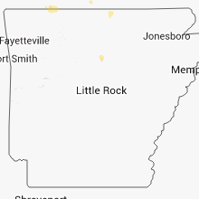
Hail Map for Wednesday, August 1, 2012

Number of Impacted Households on 8/1/2012
0
Impacted by 1" or Larger Hail
0
Impacted by 1.75" or Larger Hail
0
Impacted by 2.5" or Larger Hail
Square Miles of Populated Area Impacted on 8/1/2012
0
Impacted by 1" or Larger Hail
0
Impacted by 1.75" or Larger Hail
0
Impacted by 2.5" or Larger Hail


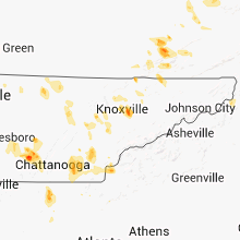


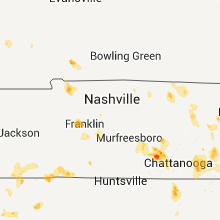
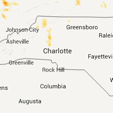


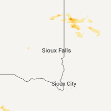


Cities Most Affected by Hail Storms of 8/1/2012
| Hail Size | Demographics of Zip Codes Affected | ||||||
|---|---|---|---|---|---|---|---|
| City | Count | Average | Largest | Pop Density | House Value | Income | Age |
| Roanoke, VA | 4 | 1.75 | 1.75 | 1225 | $98k | $40.8k | 40.1 |
| Minneota, MN | 1 | 1.75 | 1.75 | 14 | $64k | $37.2k | 43.1 |
| Porter, MN | 1 | 1.75 | 1.75 | 6 | $35k | $35.2k | 47.0 |
| Highmore, SD | 1 | 1.75 | 1.75 | 1 | $35k | $30.0k | 48.2 |
| Taunton, MN | 1 | 1.75 | 1.75 | 6 | $50k | $36.4k | 40.3 |
| Salem, VA | 1 | 1.75 | 1.75 | 344 | $104k | $40.5k | 42.1 |
| Lac Du Flambeau, WI | 1 | 1.75 | 1.75 | 21 | $129k | $30.1k | 37.4 |
| Ashland, WI | 1 | 1.75 | 1.75 | 42 | $66k | $33.2k | 40.1 |
Hail and Wind Damage Spotted on 8/1/2012
Filter by Report Type:Hail ReportsWind Reports
States Impacted
Minnesota, Wisconsin, New York, Mississippi, Tennessee, South Dakota, Virginia, Georgia, Kentucky, Montana, Nebraska, North Carolina, Missouri, Illinois, Florida, Arkansas, West Virginia, Colorado, Kansas, MichiganMinnesota
| Local Time | Report Details |
|---|---|
| 9:30 AM CDT | Boats and pontoons flipped on east lake...estimated gust 50 mp in hennepin county MN, 8.9 miles S of Minneapolis, MN |
| 9:45 AM CDT | Several large trees down and on power line in stearns county MN, 67.8 miles ENE of Montevideo, MN |
| 9:45 AM CDT | Power ou in stearns county MN, 65.6 miles ENE of Montevideo, MN |
| 9:45 AM CDT | Trees down over road near intersection hwy 22 171 s in stearns county MN, 65.6 miles ENE of Montevideo, MN |
| 5:00 PM CDT | Quarter sized hail reported near Canby, MN, 40.3 miles WSW of Montevideo, MN, very flat hail - some with a diameter to one inch. |
| 5:17 PM CDT | Golf Ball sized hail reported near Porter, MN, 27.4 miles SW of Montevideo, MN |
| 5:29 PM CDT | Golf Ball sized hail reported near Taunton, MN, 27.3 miles SSW of Montevideo, MN |
| 5:30 PM CDT | Limbs down and corn flattened in lincoln county MN, 37.6 miles SW of Montevideo, MN |
| 5:35 PM CDT | Golf Ball sized hail reported near Minneota, MN, 30 miles SSW of Montevideo, MN |
| 5:47 PM CDT | Storm damage reported in lyon county MN, 35 miles S of Montevideo, MN |
| 6:17 PM CDT | Siding torn off sides of trailer homes in lyon county MN, 36.2 miles S of Montevideo, MN |
| 6:21 PM CDT | Also receiving up to 1/2 inch hail in lyon county MN, 34.9 miles S of Montevideo, MN |
| 6:25 PM CDT | A couple of trees had damage and corn laying over in lyon county MN, 39.1 miles S of Montevideo, MN |
| 6:39 PM CDT | Storm damage reported in redwood county MN, 39.9 miles SE of Montevideo, MN |
| 6:40 PM CDT | Rwf airport aso in redwood county MN, 41.3 miles SE of Montevideo, MN |
| 6:45 PM CDT | Rwf airport aso in redwood county MN, 41.3 miles SE of Montevideo, MN |
| 6:51 PM CDT | Rwf airport aso in redwood county MN, 41.3 miles SE of Montevideo, MN |
| 7:20 PM CDT | Half Dollar sized hail reported near Currie, MN, 56.8 miles S of Montevideo, MN |
| 9:24 PM CDT | 50 ft long large tree limb down and other debri in rice county MN, 36.8 miles S of Minneapolis, MN |
| 9:34 PM CDT | Large tree dow in rice county MN, 37.4 miles S of Minneapolis, MN |
| 3:40 AM CDT | 4 to 5 foot long tree branches dow in houston county MN, 19 miles S of La Crosse, WI |
Wisconsin
| Local Time | Report Details |
|---|---|
| 11:45 AM CDT | Golf Ball sized hail reported near Ashland, WI, 68.7 miles E of Duluth, MN |
| 11:49 AM CDT | Quarter sized hail reported near Ashland, WI, 68.7 miles E of Duluth, MN |
| 5:35 PM CDT | Golf Ball sized hail reported near Lac Du Flambeau, WI, 31.7 miles NW of Rhinelander, WI, dime to golf ball size hail. report relayed by mjfw. |
| 12:03 AM CDT | A couple of trees down along hwy 12 southeast of black river falls near castle mound. time estimated by rada in jackson county WI, 38.5 miles NNE of La Crosse, WI |
| 12:25 AM CDT | One tree uprooted in the city. several branches down throughout the city. a few phone and power lines dow in clark county WI, 61.2 miles NNE of La Crosse, WI |
| 12:28 AM CDT | Tree down on roadwa in clark county WI, 61 miles NE of La Crosse, WI |
| 12:28 AM CDT | Tree blown down onto shed. time estimated using rada in jackson county WI, 55.2 miles NE of La Crosse, WI |
| 12:44 AM CDT | Quarter sized hail reported near Spencer, WI, 75.9 miles NE of La Crosse, WI |
| 1:00 AM CDT | Several reports of wind damage across southern part of the count in wood county WI, 81.1 miles ENE of La Crosse, WI |
| 1:05 AM CDT | Tree down. time estimate in portage county WI, 75.3 miles W of Green Bay, WI |
| 2:05 AM CDT | Measured in grand chut in outagamie county WI, 25.9 miles SW of Green Bay, WI |
| 4:28 AM CDT | Tree blown down in sidie hollow par in vernon county WI, 23.8 miles SE of La Crosse, WI |
| 4:30 AM CDT | Tree down on west smith roa in vernon county WI, 22.5 miles SE of La Crosse, WI |
New York
| Local Time | Report Details |
|---|---|
| 2:50 PM EDT | Localized trees down on eastern parkway and mcclellan and bradley streets in schenectady county NY, 1.1 miles E of Schenectady, NY |
Mississippi
| Local Time | Report Details |
|---|---|
| 2:19 PM CDT | Tin shed blown down on south union road. report relayed through twitte in choctaw county MS, 24.5 miles WSW of Starkville, MS |
| 3:38 PM CDT | Several trees and power lines down just west of saltill in lee county MS, 63.4 miles N of Starkville, MS |
| 3:45 PM CDT | Quarter sized hail reported near Pheba, MS, 12 miles NW of Starkville, MS, quarter sized hail and several limbs down...occurred along billy white rd. |
| 4:00 PM CDT | Tree on powerline around highway 50 and berry road. this has resulted in numerous power outages around the are in clay county MS, 13.8 miles NW of Starkville, MS |
| 4:20 PM CDT | Quarter sized hail reported near West Point, MS, 15.1 miles NNE of Starkville, MS |
| 5:00 PM CDT | Trees down along hwy 1 in choctaw county MS, 28.3 miles WSW of Starkville, MS |
| 5:19 PM CDT | Tin shed blown down on south union road. report relayed through twitte in choctaw county MS, 24.5 miles WSW of Starkville, MS |
| 5:20 PM CDT | Large tree on a house in tow in choctaw county MS, 23.3 miles WSW of Starkville, MS |
| 5:20 PM CDT | Several trees down in and around ackerman with one large tree on a house in tow in choctaw county MS, 23.3 miles WSW of Starkville, MS |
| 5:20 PM CDT | Tree uprooted in ackerman. report relayed via social media in choctaw county MS, 23.3 miles WSW of Starkville, MS |
| 5:20 PM CDT | Half Dollar sized hail reported near Ackerman, MS, 23.3 miles WSW of Starkville, MS, dime to half dollar hail has fallen for 15-20 min. |
| 5:41 PM CDT | Off duty air force officer from keesler afb reported several trees down along lorraine road near highway 67...some small hail and flooding rainfall. apparent downburs in harrison county MS, 55.7 miles WSW of Mobile, AL |
Tennessee
| Local Time | Report Details |
|---|---|
| 3:40 PM EDT | Large tree dow in anderson county TN, 21.2 miles W of Knoxville, TN |
| 3:45 PM EDT | Few trees dow in roane county TN, 35.9 miles W of Knoxville, TN |
| 3:45 PM EDT | Quarter sized hail reported near Oak Ridge, TN, 21.2 miles W of Knoxville, TN |
| 3:50 PM EDT | Quarter sized hail reported near Knoxville, TN, 17.7 miles WSW of Knoxville, TN |
| 3:50 PM EDT | Few trees dow in knox county TN, 15.8 miles WSW of Knoxville, TN |
| 3:45 PM CDT | Quarter sized hail reported near Hilham, TN, 78.4 miles ENE of Nashville, TN |
| 5:10 PM EDT | Ping Pong Ball sized hail reported near Mascot, TN, 11.3 miles NE of Knoxville, TN |
| 4:40 PM CDT | Trees down in the town of lutt in wayne county TN, 25.2 miles NNW of Florence, AL |
| 6:00 PM EDT | Several limbs and small trees dow in grainger county TN, 31 miles NE of Knoxville, TN |
| 6:00 PM EDT | Quarter sized hail reported near Bean Station, TN, 38.7 miles NE of Knoxville, TN |
| 5:04 PM CDT | Quarter sized hail reported near Dover, TN, 51.7 miles NE of Mc Kenzie, TN, also estimated winds at 65mph. |
| 5:05 PM CDT | Reports of several trees downed across southwestern portions of the count in wayne county TN, 31.2 miles NNW of Florence, AL |
| 5:08 PM CDT | Trees down around the indian mound community in stewart count in stewart county TN, 50.6 miles ENE of Mc Kenzie, TN |
| 5:15 PM CDT | Near the indian mound community...highway 46 blocked in several locations by fallen trees and powerline in stewart county TN, 50.6 miles ENE of Mc Kenzie, TN |
| 6:25 PM EDT | Quarter sized hail reported near Englewood, TN, 49.1 miles SW of Knoxville, TN |
| 6:28 PM EDT | Several trees donw in maynardvill in union county TN, 20.9 miles NNE of Knoxville, TN |
| 5:32 PM CDT | Multiple trees and power lines down in bordeau in davidson county TN, 5.3 miles WSW of Nashville, TN |
| 5:39 PM CDT | Multiple trees and power lines down in bordeau in davidson county TN, 5.3 miles WSW of Nashville, TN |
| 6:40 PM EDT | Quarter sized hail reported near Etowah, TN, 48.3 miles ENE of Chattanooga, TN |
| 5:47 PM CDT | Sizeable branch ripped off tree near music ro in davidson county TN, 0.7 miles SE of Nashville, TN |
| 5:50 PM CDT | Numerous tree reported down in crieve hall along blackman road in davidson county TN, 8.8 miles S of Nashville, TN |
| 5:55 PM CDT | In crieve hall...a couple of houses with fallen trees on them...no injuries. downed power lines in the roa in davidson county TN, 8.8 miles S of Nashville, TN |
| 6:47 PM CDT | Quarter sized hail reported near Bon Aqua, TN, 36.6 miles WSW of Nashville, TN, hail reported in bon aqua in hickman county |
| 8:53 PM EDT | Half Dollar sized hail reported near Cleveland, TN, 26.5 miles ENE of Chattanooga, TN |
| 8:30 PM CDT | Numerous trees were blown down all around tullahom in coffee county TN, 56.1 miles WNW of Chattanooga, TN |
| 8:35 PM CDT | Several trees down in normand in bedford county TN, 57.4 miles SSE of Nashville, TN |
| 9:10 PM CDT | Several trees and powerlines down across the count in grundy county TN, 35.6 miles NW of Chattanooga, TN |
| 9:35 PM CDT | Several trees down in marion county TN, 16.7 miles WNW of Chattanooga, TN |
South Dakota
| Local Time | Report Details |
|---|---|
| 1:45 PM MDT | Storm damage reported in pennington county SD, 53 miles E of Rapid City, SD |
| 1:55 PM MDT | Quarter sized hail reported near Philip, SD, 64.9 miles E of Rapid City, SD |
| 2:40 PM MDT | Storm damage reported in bennett county SD, 72.8 miles WNW of Valentine, NE |
| 3:55 PM CDT | Peak wind gust from the fort pierre raw in lyman county SD, 17.4 miles S of Pierre, SD |
| 4:00 PM CDT | Pea to nickel hail at residence and 40 to 50 mph winds. 1 mile south - major crop damage to sunflower fields on several sections of lan in hughes county SD, 30.7 miles E of Pierre, SD |
| 3:05 PM MDT | Storm damage reported in jackson county SD, 66.3 miles NW of Valentine, NE |
| 4:10 PM CDT | Winds estimated at least 60 mph with pea sized hai in stanley county SD, 4.5 miles SSE of Pierre, SD |
| 4:35 PM CDT | Golf Ball sized hail reported near Highmore, SD, 47.4 miles E of Pierre, SD, a few golfball hail but mostly nickel. covers the ground. |
| 7:30 PM CDT | A few small branches down in charles mix county SD, 60.9 miles N of Oneill, NE |
Virginia
| Local Time | Report Details |
|---|---|
| 3:59 PM EDT | Quarter sized hail reported near Millboro, VA, 52.8 miles NNE of Roanoke, VA, state route 633 |
| 4:25 PM EDT | Half Dollar sized hail reported near McDowell, VA, 47.8 miles SSE of Elkins, WV |
| 4:25 PM EDT | Quarter sized hail reported near Millboro, VA, 52.3 miles NNE of Roanoke, VA, hail ranged from nickel to quarter size |
| 4:25 PM EDT | Ping Pong Ball sized hail reported near Millboro, VA, 51.7 miles NNE of Roanoke, VA, ping pong size hail in millboro |
| 5:20 PM EDT | Quarter sized hail reported near Glasgow, VA, 38.4 miles NE of Roanoke, VA, hail fell for about 5 minutes near us 11. hail ranged from pea to quarter size. |
| 5:44 PM EDT | Branches down in frederick county VA, 85.9 miles W of Baltimore, MD |
| 6:20 PM EDT | Quarter sized hail reported near Roanoke, VA, 6 miles NW of Roanoke, VA, hail ranging from dime to quarter size near glen cove elementary school. |
| 6:20 PM EDT | Quarter sized hail reported near Victoria, VA, 42.5 miles SW of Richmond, VA |
| 6:25 PM EDT | Quarter sized hail reported near Roanoke, VA, 5.1 miles NW of Roanoke, VA, hail ranged from dime size to quarter size on green ridge road |
| 6:25 PM EDT | Golf Ball sized hail reported near Roanoke, VA, 6 miles NW of Roanoke, VA, golf ball size hail reported |
| 6:28 PM EDT | Quarter sized hail reported near Salem, VA, 5.3 miles WNW of Roanoke, VA, quarter size hail on electric road |
| 6:30 PM EDT | Tree down in wis in wise county VA, 33.3 miles NW of Bristol, TN |
| 6:32 PM EDT | Quarter sized hail reported near Roanoke, VA, 3.4 miles NW of Roanoke, VA, quarter size hail reported at the wdbj studio. |
| 6:35 PM EDT | Golf Ball sized hail reported near Roanoke, VA, 4.6 miles NNW of Roanoke, VA, golf ball size hail on peters creek road |
| 6:36 PM EDT | Quarter sized hail reported near Wise, VA, 33.3 miles NW of Bristol, TN, nickel to quarter sized hail |
| 6:38 PM EDT | Golf Ball sized hail reported near Salem, VA, 4.4 miles W of Roanoke, VA, golf ball size hail in east salem near the medical center |
| 6:38 PM EDT | Golf Ball sized hail reported near Roanoke, VA, 3.8 miles WNW of Roanoke, VA, golf ball size hail on virginia ave |
| 6:45 PM EDT | Golf Ball sized hail reported near Roanoke, VA, 3.1 miles WSW of Roanoke, VA, golf ball size hail on livingston road |
| 6:48 PM EDT | Quarter sized hail reported near Roanoke, VA, 5 miles SSW of Roanoke, VA, quarter size hail on pine court road |
| 6:56 PM EDT | Quarter sized hail reported near Roanoke, VA, 0.1 miles SSE of Roanoke, VA, quarter size hail on 3rd street sw across from the city court house |
| 7:06 PM EDT | Quarter sized hail reported near Boones Mill, VA, 10.5 miles S of Roanoke, VA, quarter size hail in boones mill |
| 7:15 PM EDT | Power lines down on indian grave road near rt 220 in roanoke county VA, 5 miles S of Roanoke, VA |
| 8:15 PM EDT | Quarter sized hail reported near Brookneal, VA, 67.1 miles ESE of Roanoke, VA, quarter size hail on woodburn lane |
Georgia
| Local Time | Report Details |
|---|---|
| 4:14 PM EDT | Chattoga county em relayed a report of three trees down in the county. time is based on rada in chattooga county GA, 36.9 miles S of Chattanooga, TN |
| 4:37 PM EDT | Forsyth ema relayed a report of trees down on houses...powerlines down...street lights and stoplights downed by thunderstorm wind across the county. also 4 mobile homes in forsyth county GA, 34.9 miles NNE of Atlanta, GA |
| 4:37 PM EDT | Forsyth ema relayed a report of trees down on houses...powerlines down...street lights and stoplights downed by thunderstorm wind across the count in forsyth county GA, 34.9 miles NNE of Atlanta, GA |
| 7:21 PM EDT | Nssl research team has relayed a report of snapped trees in this area. a pecan tree was snapped at the base and landed on the roof of a barn. time is based on rada in walker county GA, 27.3 miles S of Chattanooga, TN |
| 7:27 PM EDT | Quarter sized hail reported near La Fayette, GA, 26.6 miles S of Chattanooga, TN, noaa research group relayed a report of quarter sized hail. |
| 7:34 PM EDT | Chattooga county em relayed a report of numerous trees down in teloga. time is based on rada in chattooga county GA, 35 miles S of Chattanooga, TN |
| 7:35 PM EDT | Quarter sized hail reported near Trion, GA, 30.1 miles S of Chattanooga, TN |
| 7:40 PM EDT | Walker county 911 relayed a report of 5 trees down in the southern part of the county. time is based on rada in walker county GA, 23.2 miles S of Chattanooga, TN |
| 9:15 PM EDT | 911 call center relayed a report of a tree down in northern whitfield count in whitfield county GA, 21.2 miles ESE of Chattanooga, TN |
| 11:15 PM EDT | Law enforcement reported several trees down in the wildwood are in dade county GA, 7.8 miles SW of Chattanooga, TN |
Kentucky
| Local Time | Report Details |
|---|---|
| 4:25 PM EDT | One tree down on route 4 in martin county KY, 61.5 miles WSW of Charleston, WV |
| 4:35 PM EDT | Tree fell on a car on hwy 522. numerous other trees downed in the are in harlan county KY, 62.6 miles WNW of Bristol, TN |
| 5:00 PM EDT | Trees down along meathouse cree in martin county KY, 64 miles SW of Charleston, WV |
| 5:25 PM EDT | Several trees and large limbs blown down around the big laurel communit in harlan county KY, 61.5 miles WNW of Bristol, TN |
| 6:36 PM EDT | Quarter sized hail reported near Hazard, KY, 52.7 miles SE of Irvine, KY, hail lasted for about a half hour near cardinal chevrolet. |
| 8:25 PM EDT | One tree down on route 4 in martin county KY, 61.5 miles WSW of Charleston, WV |
Montana
| Local Time | Report Details |
|---|---|
| 2:55 PM MDT | Quarter sized hail reported near Peerless, MT, 64.5 miles NE of Glasgow, MT, hail the size of dimes and quarters. |
| 3:45 PM MDT | Ping Pong Ball sized hail reported near Reserve, MT, 66.4 miles WNW of Williston, ND |
| 3:45 PM MDT | Quarter sized hail reported near Reserve, MT, 69.2 miles WNW of Williston, ND, accompanied by 60 mph winds. |
| 3:45 PM MDT | Ping Pong Ball sized hail reported near Reserve, MT, 64.5 miles WNW of Williston, ND |
| 4:35 PM MDT | Storm damage reported in roosevelt county MT, 42.5 miles WNW of Williston, ND |
Nebraska
| Local Time | Report Details |
|---|---|
| 2:55 PM MDT | 50 to 60 mph winds with dime hai in sheridan county NE, 67.8 miles ENE of Scottsbluff, NE |
| 5:58 PM CDT | Storm damage reported in cherry county NE, 0.3 miles S of Valentine, NE |
| 6:05 PM CDT | Storm damage reported in cherry county NE, 0.3 miles S of Valentine, NE |
| 5:15 PM MDT | Small branches down. dime size hail also reporte in arthur county NE, 49.6 miles WNW of North Platte, NE |
| 7:02 PM CDT | Storm damage reported in brown county NE, 36.3 miles SE of Valentine, NE |
| 7:15 PM CDT | Thunderstorm wind gust estimated as high as 60 mph from 715 pm cdt through 720 pm cdt. lightning caused hay fires in fields nearby around 730 pm cdt. delayed reports fr in brown county NE, 57.4 miles WSW of Oneill, NE |
| 7:20 PM CDT | Branches down. power out at locatio in brown county NE, 61.9 miles SE of Valentine, NE |
| 8:17 PM CDT | Storm damage reported in holt county NE, 27.7 miles SW of Oneill, NE |
| 8:17 PM CDT | Ping Pong Ball sized hail reported near North Platte, NE, 6 miles S of North Platte, NE, quarter to ping pong ball sized hail reported at lake maloney. |
| 10:29 PM CDT | Delayed wind damage report from wednesday evening. a three-story barn destroyed...along with other nearby outbuilding damage. time estimated from rada in sherman county NE, 38.5 miles WNW of Grand Island, NE |
| 10:55 PM CDT | Storm damage reported in wayne county NE, 84.7 miles E of Oneill, NE |
| 10:59 PM CDT | A few tree limbs dow in wayne county NE, 86.2 miles NW of Omaha, NE |
| 11:00 PM CDT | 6 inch diameter limbs broken in dixon county NE, 87.3 miles NW of Omaha, NE |
North Carolina
| Local Time | Report Details |
|---|---|
| 5:12 PM EDT | Rolesville fd received report of tree down on zebulon r in wake county NC, 16.9 miles NE of Raleigh, NC |
| 5:23 PM EDT | Rolesville fd received report of tree down on quarry roa in wake county NC, 14.3 miles NE of Raleigh, NC |
| 5:39 PM EDT | Wake co 911 received report of 2 trees down on fowler rd in zebulo in wake county NC, 18.3 miles E of Raleigh, NC |
| 6:09 PM EDT | Wake co 911 received report of power lines down on durham r in wake county NC, 12.7 miles N of Raleigh, NC |
| 6:29 PM EDT | Several trees down in murph in cherokee county NC, 60.3 miles S of Knoxville, TN |
| 11:42 PM EDT | Tree down on house on blue ridge avenue in boon in watauga county NC, 40 miles SE of Bristol, TN |
| 11:48 PM EDT | Trees down on bamboo road near boon in watauga county NC, 42.6 miles SE of Bristol, TN |
| 12:00 AM EDT | Quarter sized hail reported near Jefferson, NC, 43.5 miles ESE of Bristol, TN, public reported quarter-sized hail in jefferson. |
| 12:40 AM EDT | Trees down on johnson road near hay in wilkes county NC, 68.1 miles ESE of Bristol, TN |
| 12:48 AM EDT | Trees and powerlines reported down around north wilkesboro with power out across much of the are in wilkes county NC, 66.9 miles ESE of Bristol, TN |
| 1:14 AM EDT | Trees and powerlines down along state route 16 just south of moravian fall in wilkes county NC, 60.4 miles NNW of Charlotte, NC |
| 1:45 AM EDT | One tree blown down in downtown taylorsvill in alexander county NC, 51.8 miles NNW of Charlotte, NC |
| 2:05 AM EDT | Quarter sized hail reported near Taylorsville, NC, 48 miles NNW of Charlotte, NC |
| 2:10 AM EDT | Dispatch reports a tree on a home near conove in catawba county NC, 41.7 miles NNW of Charlotte, NC |
| 2:10 AM EDT | Media reports trees down across eastover d in catawba county NC, 42.9 miles NNW of Charlotte, NC |
| 2:29 AM EDT | Trees and branches down around the rock barn golf cours in catawba county NC, 40.6 miles NNW of Charlotte, NC |
Missouri
| Local Time | Report Details |
|---|---|
| 4:14 PM CDT | Large tree completely blocking exit to dogwood canyon nature par in stone county MO, 47.7 miles SSW of Springfield, MO |
| 4:27 PM CDT | Branson asos reported 56 knots or 64 mph wind gust in taney county MO, 46.4 miles S of Springfield, MO |
| 6:27 PM CDT | A pontoon boat was overturned from strong winds and rough water over table rock lake. this event happened between point 10 and point 11 on the lake. no injuries reporte in stone county MO, 46 miles SSW of Springfield, MO |
| 6:40 PM CDT | Several large trees blown down and power lines down across the branson are in taney county MO, 39.4 miles S of Springfield, MO |
Illinois
| Local Time | Report Details |
|---|---|
| 4:40 PM CDT | Tree limbs down and 1 tree caught on fire due to lightning s in johnson county IL, 34 miles E of Cape Girardeau, MO |
| 5:30 PM CDT | Trees...power lines...and a couple homes damaged. time estimated based on rada in union county IL, 23.2 miles E of Cape Girardeau, MO |
Florida
| Local Time | Report Details |
|---|---|
| 5:50 PM EDT | Trees downed with estimated winds of 50 to 6 in palm beach county FL, 53.1 miles SSE of Port Saint Lucie, FL |
| 6:20 PM EDT | Strong winds downed a large tree onto an automobil in palm beach county FL, 51.2 miles N of Miami, FL |
Arkansas
| Local Time | Report Details |
|---|---|
| 5:10 PM CDT | Update from previous lsr. trees were blown down and several blocked roads. a business sign was blown down onto a vehicle. the vehicle was not occupied. power lines were in boone county AR, 67.5 miles S of Springfield, MO |
| 5:48 PM CDT | Atleast two boat docks were overturned and a power line was down in bull shoal in marion county AR, 69.1 miles SE of Springfield, MO |
| 6:09 PM CDT | Several large trees were blown down in yellville. one tree was reported to have fallen on a hous in marion county AR, 75.3 miles SSE of Springfield, MO |
| 6:34 PM CDT | Tress and power lines are down. some power poles were snapped. tin roofing was removed from several houses...mtress and power lines are dow in fulton county AR, 88.8 miles SSW of Salem, MO |
| 6:36 PM CDT | Power lines were down at highway 223 north and browns chapel road in mount calm. winds caused damage to two homes and two barns. a semi truck and a horse trailer were b in fulton county AR, 86 miles SSW of Salem, MO |
| 6:43 PM CDT | Many people are without powe in fulton county AR, 88.8 miles S of Salem, MO |
| 6:47 PM CDT | Several power lines and power poles were blown down. tin roofing was removed from several structures on the west side of sale in fulton county AR, 88.8 miles S of Salem, MO |
| 7:17 PM CDT | Multiple trees are down with trees reported on houses and vehicles. no injuries are being reported at this time. power lines and power poles were blown dow in sharp county AR, 97 miles S of Salem, MO |
West Virginia
| Local Time | Report Details |
|---|---|
| 6:15 PM EDT | Reports of several trees down in clendenin along elk river road and valley view drive in kanawha county WV, 5.2 miles WSW of Charleston, WV |
| 6:30 PM EDT | Tree down on elk river r in kanawha county WV, 18.4 miles ENE of Charleston, WV |
| 8:52 PM EDT | Large branches down in hardy county WV, 57.9 miles E of Elkins, WV |
Colorado
| Local Time | Report Details |
|---|---|
| 5:56 PM MDT | Storm damage reported in yuma county CO, 3.9 miles ESE of Yuma, CO |
Kansas
| Local Time | Report Details |
|---|---|
| 1:05 AM CDT | Est 60 mph wind gust. 8 inch tree branch knocked down plus several other branche in jewell county KS, 72.1 miles S of Grand Island, NE |
| 1:05 AM CDT | There were several small branches down. largest branch was 5 inches in diamete in jewell county KS, 72.8 miles S of Grand Island, NE |
| 1:05 AM CDT | Est 60 mph wind gust. 8 inch tree branch knock down plus several other branche in jewell county KS, 72.1 miles S of Grand Island, NE |
| 2:30 AM CDT | Tree limbs down and 2.15 inches of rai in washington county KS, 52.4 miles NNW of Manhattan, KS |
| 2:30 AM CDT | Tree branches and power lines down in town in washington county KS, 51.4 miles NNW of Manhattan, KS |
| 2:30 AM CDT | 2 inch tree branches down through out northern riley count in riley county KS, 25.3 miles NW of Manhattan, KS |
| 3:00 AM CDT | 3 inch tree branches down and power outages through out marshall county in marshall county KS, 45.9 miles N of Manhattan, KS |
| 3:20 AM CDT | 12 inch diameter tree blown down. time estimate in pottawatomie county KS, 7.7 miles E of Manhattan, KS |
Michigan
| Local Time | Report Details |
|---|---|
| 5:40 AM EDT | Measured at big sable point lighthous in lmz849 county MI, 65.9 miles SW of Traverse City, MI |
| 5:40 AM EDT | The ludington daily news is reporting numerous trees are down in ludington state park...causing damage to camper trailers...vehicles...and possibly a park building as w in mason county MI, 66.8 miles SW of Traverse City, MI |
Connect with Interactive Hail Maps