

Hail Map for Thursday, August 15, 2019

Number of Impacted Households on 8/15/2019
0
Impacted by 1" or Larger Hail
0
Impacted by 1.75" or Larger Hail
0
Impacted by 2.5" or Larger Hail
Square Miles of Populated Area Impacted on 8/15/2019
0
Impacted by 1" or Larger Hail
0
Impacted by 1.75" or Larger Hail
0
Impacted by 2.5" or Larger Hail

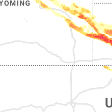


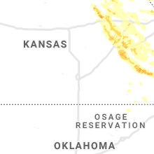


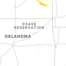


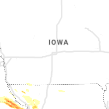


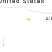
Cities Most Affected by Hail Storms of 8/15/2019
| Hail Size | Demographics of Zip Codes Affected | ||||||
|---|---|---|---|---|---|---|---|
| City | Count | Average | Largest | Pop Density | House Value | Income | Age |
| Scottsbluff, NE | 7 | 1.93 | 2.75 | 157 | $75k | $31.0k | 37.9 |
| Gering, NE | 3 | 1.83 | 2.00 | 52 | $75k | $34.5k | 38.2 |
| Torrington, WY | 3 | 1.83 | 2.00 | 13 | $79k | $33.0k | 43.0 |
| Hiawatha, KS | 2 | 2.25 | 2.75 | 23 | $60k | $34.0k | 43.0 |
| Manhattan, KS | 2 | 1.88 | 2.00 | 189 | $107k | $41.5k | 29.0 |
| Broadwater, NE | 2 | 1.88 | 2.00 | 1 | $23k | $26.8k | 47.6 |
| Minatare, NE | 2 | 1.75 | 1.75 | 9 | $46k | $31.0k | 41.7 |
| Topeka, KS | 2 | 1.75 | 1.75 | 615 | $123k | $60.9k | 42.0 |
| Guernsey, WY | 1 | 2.75 | 2.75 | 0 | $68k | $31.9k | 46.2 |
| Lingle, WY | 1 | 2.50 | 2.50 | 3 | $78k | $36.6k | 46.5 |
| Riley, KS | 1 | 2.00 | 2.00 | 31 | $61k | $37.0k | 36.7 |
| Leonardville, KS | 1 | 2.00 | 2.00 | 8 | $42k | $35.1k | 44.1 |
| Sabetha, KS | 1 | 2.00 | 2.00 | 24 | $59k | $38.8k | 41.3 |
| Evansville, WY | 1 | 1.75 | 1.75 | 30 | $150k | $50.6k | 34.4 |
| Denton, KS | 1 | 1.75 | 1.75 | 6 | $43k | $32.3k | 48.0 |
| Parker, KS | 1 | 1.75 | 1.75 | 12 | $55k | $39.2k | 39.8 |
| Bridgeport, NE | 1 | 1.75 | 1.75 | 2 | $50k | $30.3k | 42.9 |
| Vermillion, KS | 1 | 1.75 | 1.75 | 4 | $25k | $32.1k | 50.9 |
| Bern, KS | 1 | 1.75 | 1.75 | 6 | $45k | $39.7k | 41.7 |
| Morrill, NE | 1 | 1.75 | 1.75 | 8 | $55k | $31.2k | 42.7 |
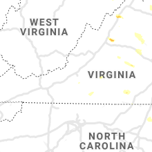
Hail and Wind Damage Spotted on 8/15/2019
Filter by Report Type:Hail ReportsWind Reports
States Impacted
Virginia, Pennsylvania, North Dakota, Ohio, New York, South Dakota, West Virginia, Kansas, Wyoming, Nebraska, North Carolina, Maryland, Missouri, Georgia, TexasVirginia
| Local Time | Report Details |
|---|---|
| 1:12 PM EDT | Tree knocked down on vogel rd. time estimated from rada in cumberland county VA, 36.3 miles W of Richmond, VA |
| 1:14 PM EDT | Tree knocked down on trents mill rd. time estimated from rada in cumberland county VA, 35.8 miles W of Richmond, VA |
| 1:15 PM EDT | Tree down on a car near 45n and route 60. multiple other trees down on the road in the area. time estimated by rada in cumberland county VA, 30.7 miles W of Richmond, VA |
| 2:00 PM EDT | Trees down along flint hill r in powhatan county VA, 9.1 miles WNW of Richmond, VA |
| 2:20 PM EDT | Rt 50 both lanes shut down at four chimneys ln due to power lines dow in loudoun county VA, 62.6 miles WSW of Baltimore, MD |
| 2:40 PM EDT | Tree down blocking driveway to briar patch bed and breakfast in in loudoun county VA, 60.4 miles WSW of Baltimore, MD |
| 2:41 PM EDT | Tree down on us-5 in loudoun county VA, 62.1 miles WSW of Baltimore, MD |
| 2:45 PM EDT | Tree down on us 15 near braddock roa in loudoun county VA, 58.9 miles WSW of Baltimore, MD |
| 3:04 PM EDT | Tree down burnett dr near newbys bridge r in chesterfield county VA, 7.1 miles SE of Richmond, VA |
| 3:07 PM EDT | Tree down mason run d in chesterfield county VA, 11 miles ESE of Richmond, VA |
| 3:10 PM EDT | Trees down on woodward d in chesterfield county VA, 5.6 miles E of Richmond, VA |
| 3:15 PM EDT | Trees down on lair d in chesterfield county VA, 11.4 miles SE of Richmond, VA |
| 3:15 PM EDT | Reported tree on a house at 7011 mason run d in chesterfield county VA, 11 miles ESE of Richmond, VA |
| 3:19 PM EDT | Storm damage reported in fairfax county VA, 51.2 miles WSW of Baltimore, MD |
| 3:32 PM EDT | Tree down on sully road under willard roa in fairfax county VA, 53 miles WSW of Baltimore, MD |
| 3:40 PM EDT | Tree down on the 6600 block of briar croft roa in fairfax county VA, 54.3 miles SW of Baltimore, MD |
| 3:40 PM EDT | Trees down in windsor. tree on a car at the high schoo in isle of wight county VA, 38 miles W of Virginia Beach, VA |
| 3:44 PM EDT | Trees down shiloh rd and briggs wa in isle of wight county VA, 36.3 miles W of Virginia Beach, VA |
| 3:55 PM EDT | Tree knocked down on harrison point d in charles city county VA, 26.6 miles ESE of Richmond, VA |
| 4:06 PM EDT | Trees down across west washington s in city of suffolk county VA, 30.1 miles W of Virginia Beach, VA |
| 5:12 PM EDT | A tree and branches downed on route 130. time estimated from rada in amherst county VA, 44.2 miles ENE of Roanoke, VA |
| 5:15 PM EDT | Tree down on a power line near the jamestown scotland ferry pie in james city county VA, 51.3 miles ESE of Richmond, VA |
| 5:50 PM EDT | Damage to barns report along old valley road near daniel gray driv in shenandoah county VA, 66.1 miles E of Elkins, WV |
| 5:50 PM EDT | Multiple trees reported down in the area of turkey knob road and wissler roa in shenandoah county VA, 64.8 miles ESE of Elkins, WV |
| 5:55 PM EDT | Quarter sized hail reported near Mount Jackson, VA, 66.5 miles E of Elkins, WV |
| 5:55 PM EDT | Reports of multiple barns damaged along old valley pike and red banks road in shenandoah county VA, 67.9 miles E of Elkins, WV |
| 5:55 PM EDT | Tree down on a power line on berry st. time estimated by rada in mecklenburg county VA, 65.9 miles SW of Richmond, VA |
| 5:55 PM EDT | Tree down on country club drive. time estimated by rada in mecklenburg county VA, 65 miles SW of Richmond, VA |
| 5:55 PM EDT | Tree down in the area of 31007 hwy 49. time estimated by rada in mecklenburg county VA, 63.5 miles SW of Richmond, VA |
| 6:03 PM EDT | Reports of multiple barns damaged along old valley pike and red banks road in shenandoah county VA, 71.5 miles E of Elkins, WV |
| 6:25 PM EDT | Tree across baskerville rd (va 669) near wooden bridge rd (va 674 in mecklenburg county VA, 65.6 miles NNE of Raleigh, NC |
| 6:30 PM EDT | A few trees were down near lura in page county VA, 78.2 miles ESE of Elkins, WV |
| 7:00 PM EDT | Quarter sized hail reported near Fort Defiance, VA, 66.8 miles SE of Elkins, WV |
| 7:04 PM EDT | Trees were down in comertown and fleeburg in page county VA, 73.8 miles ESE of Elkins, WV |
| 7:07 PM EDT | Half Dollar sized hail reported near Fort Defiance, VA, 71.6 miles SE of Elkins, WV |
| 8:09 PM EDT | Tree down on carpenter mill road near tom johnston roa in madison county VA, 66.6 miles NNW of Richmond, VA |
| 8:25 PM EDT | Tree down near the intersection of georgetown farm road and millington roa in albemarle county VA, 67.6 miles NW of Richmond, VA |
| 8:47 PM EDT | Trees down on a house in the 100 block of scott stree in orange county VA, 57.3 miles NNW of Richmond, VA |
| 8:59 PM EDT | Trees down on a house in the 18000 block of constitution highwa in orange county VA, 57.3 miles NNW of Richmond, VA |
| 8:59 PM EDT | Trees down on a house in the 18000 block of constitution highwa in orange county VA, 55.5 miles NNW of Richmond, VA |
| 9:00 PM EDT | Approximately 30 trees down throughout the central portion of orange count in orange county VA, 57.3 miles NNW of Richmond, VA |
| 9:21 PM EDT | Tree down on wires in the 1800 block of saint john roa in albemarle county VA, 53.1 miles NW of Richmond, VA |
| 9:30 PM EDT | Tree down on bethlehem road. time from rada in franklin county VA, 12.8 miles SSW of Roanoke, VA |
| 10:25 PM EDT | Trees down near minera in louisa county VA, 34.3 miles NNW of Richmond, VA |
| 10:40 PM EDT | Trees down at mm 154 off i-6 in goochland county VA, 29.4 miles NW of Richmond, VA |
Pennsylvania
| Local Time | Report Details |
|---|---|
| 2:07 PM EDT | Quarter sized hail reported near Mercer, PA, 53.5 miles NNW of Pittsburgh, PA |
| 2:30 PM EDT | Report of trees down near wallace and sardis road in westmoreland county PA, 17 miles E of Pittsburgh, PA |
| 2:40 PM EDT | Quarter sized hail reported near Stoneboro, PA, 62.5 miles N of Pittsburgh, PA |
| 2:55 PM EDT | Tree fell on house and ruptured gas lin in allegheny county PA, 6.8 miles SW of Pittsburgh, PA |
| 2:58 PM EDT | Tree down on hous in allegheny county PA, 5.5 miles SW of Pittsburgh, PA |
| 3:03 PM EDT | Two trees blocking fort couch r in allegheny county PA, 7.3 miles SSW of Pittsburgh, PA |
| 3:12 PM EDT | Downed power lines and tree limb in allegheny county PA, 4.9 miles SSE of Pittsburgh, PA |
| 3:30 PM EDT | Downed trees and powerline in indiana county PA, 33.1 miles ENE of Pittsburgh, PA |
| 3:31 PM EDT | A number of trees and power lines down across young townshi in indiana county PA, 33.9 miles ENE of Pittsburgh, PA |
| 3:35 PM EDT | Quarter sized hail reported near Mckeesport, PA, 11.2 miles ESE of Pittsburgh, PA |
| 3:40 PM EDT | Trees and powerlines down on roa in westmoreland county PA, 14.5 miles SE of Pittsburgh, PA |
| 3:45 PM EDT | Trees and power lines down across the roa in armstrong county PA, 36.4 miles NE of Pittsburgh, PA |
| 4:00 PM EDT | Tree down on home on northwood drive. time estimated by rada in lycoming county PA, 55.3 miles NE of State College, PA |
| 4:00 PM EDT | A few trees down near divine providence medical cente in lycoming county PA, 56.2 miles NE of State College, PA |
| 4:05 PM EDT | Several reports of trees and wires down near and northeast of weatherly. time estimated from rada in carbon county PA, 31.8 miles SSW of Scranton, PA |
| 4:07 PM EDT | Trees and wires down on route 12 in clinton county PA, 37.5 miles N of State College, PA |
| 4:56 PM EDT | Tree down on dairy r in washington county PA, 21.7 miles WSW of Pittsburgh, PA |
| 5:00 PM EDT | A few trees dow in blair county PA, 37.5 miles SW of State College, PA |
| 5:01 PM EDT | Quarter sized hail reported near New Castle, PA, 42.7 miles NNW of Pittsburgh, PA |
| 5:06 PM EDT | Quarter sized hail reported near New Castle, PA, 44.7 miles NNW of Pittsburgh, PA |
| 5:15 PM EDT | Quarter sized hail reported near Hollidaysburg, PA, 34.5 miles SW of State College, PA |
| 5:20 PM EDT | Multiple trees down between pa-44 and wild cat r in potter county PA, 74.7 miles SSE of Buffalo, NY |
| 5:30 PM EDT | Trees and wires down on juniata valley rd between linds crossing rd and upper reese r in blair county PA, 33.8 miles SW of State College, PA |
| 5:55 PM EDT | Trees and wires dow in huntingdon county PA, 7.4 miles SSW of State College, PA |
| 6:01 PM EDT | Trees and wires down near whipple dam state par in huntingdon county PA, 6 miles SSE of State College, PA |
| 6:07 PM EDT | Trees and wires down on juniata gap rd near penn state altoon in blair county PA, 33.8 miles WSW of State College, PA |
| 6:19 PM EDT | Multiple trees and power lines down across jefferson township in mercer county PA, 61 miles NNW of Pittsburgh, PA |
| 6:25 PM EDT | Trees and wires down across sugar grove roa in huntingdon county PA, 21.9 miles S of State College, PA |
| 6:25 PM EDT | Trees and wires down in huntingdon county PA, 21.8 miles S of State College, PA |
| 6:26 PM EDT | Multiple trees and power lines down across delaware townshi in mercer county PA, 64.1 miles NNW of Pittsburgh, PA |
| 6:27 PM EDT | Trees and wire down in huntingdon county PA, 23.2 miles S of State College, PA |
| 7:00 PM EDT | Numerous trees dow in mckean county PA, 73.4 miles NNW of State College, PA |
| 7:15 PM EDT | Multiple trees snapped and uproote in crawford county PA, 76.1 miles N of Pittsburgh, PA |
| 7:20 PM EDT | Multiple trees down in keating tw in mckean county PA, 76.3 miles NNW of State College, PA |
| 7:25 PM EDT | A few trees and wires dow in bedford county PA, 45.2 miles SSW of State College, PA |
| 7:26 PM EDT | Multiple trees down along state highway 2 in crawford county PA, 80.2 miles N of Pittsburgh, PA |
| 7:53 PM EDT | Multiple trees down in lack and tuscarora twp in juniata county PA, 32.3 miles SSE of State College, PA |
| 8:12 PM EDT | Tree reported dow in crawford county PA, 76.5 miles E of Cleveland, OH |
| 8:23 PM EDT | Quarter sized hail reported near Kane, PA, 77.6 miles NW of State College, PA |
| 9:15 PM EDT | Half Dollar sized hail reported near Union City, PA, 83.1 miles SW of Buffalo, NY, quarter to half dollar sized hail reported. |
| 9:28 PM EDT | Quarter sized hail reported near Union City, PA, 78.2 miles SW of Buffalo, NY, social media report of 1 inch hail on route 89 between wattsburg and corry. |
| 9:45 PM EDT | Multiple trees down in dickinson tw in cumberland county PA, 57.7 miles SE of State College, PA |
| 9:48 PM EDT | Tree down near ricketts glen hote in luzerne county PA, 33.8 miles WSW of Scranton, PA |
| 9:50 PM EDT | Numerous trees dow in cumberland county PA, 59.3 miles SE of State College, PA |
| 10:02 PM EDT | Wires down on apache driv in luzerne county PA, 30.5 miles WSW of Scranton, PA |
| 10:20 PM EDT | Numerous trees dow in york county PA, 60.8 miles NNW of Baltimore, MD |
North Dakota
| Local Time | Report Details |
|---|---|
| 1:15 PM CDT | Quarter sized hail reported near Fredonia, ND, 61.6 miles NW of Aberdeen, SD |
Ohio
| Local Time | Report Details |
|---|---|
| 2:26 PM EDT | Quarter sized hail reported near , , 78.8 miles W of Cleveland, OH, quarter to half-dollar size hail. |
| 2:27 PM EDT | 6 inch diameter tree branch dow in ottawa county OH, 78.8 miles W of Cleveland, OH |
| 2:30 PM EDT | 30 ft tree down on power lin in ottawa county OH, 78.8 miles W of Cleveland, OH |
| 2:30 PM EDT | Aluminum horse trailer toppled by win in ottawa county OH, 79.4 miles W of Cleveland, OH |
New York
| Local Time | Report Details |
|---|---|
| 3:36 PM EDT | Trees down on wolf run rd in portville in cattaraugus county NY, 60.4 miles SSE of Buffalo, NY |
| 3:45 PM EDT | Storm damage reported in cattaraugus county NY, 39.7 miles SE of Buffalo, NY |
| 4:09 PM EDT | Half Dollar sized hail reported near Rushford, NY, 46.9 miles SE of Buffalo, NY |
| 4:10 PM EDT | Pole and wires down near 903 ridge rd in chemung county NY, 65.1 miles SSW of Syracuse, NY |
| 4:10 PM EDT | Pole and wires down near 903 ridge rd in chemung county NY, 70 miles SSW of Syracuse, NY |
| 4:44 PM EDT | Quarter sized hail reported near Avon, NY, 61.4 miles E of Buffalo, NY |
| 4:45 PM EDT | Quarter sized hail reported near Avon, NY, 61.4 miles E of Buffalo, NY |
| 4:47 PM EDT | Tree down on trailer in livingston county NY, 58.9 miles E of Buffalo, NY |
| 4:47 PM EDT | Half Dollar sized hail reported near Lima, NY, 63.9 miles E of Buffalo, NY |
| 5:29 PM EDT | Tree down on wires near 17 academy street in cortland county NY, 42.5 miles S of Syracuse, NY |
| 5:34 PM EDT | Tree down on roadway near 6138 county road 29 in steuben county NY, 75.4 miles ESE of Buffalo, NY |
| 6:13 PM EDT | Large tree branch down on wires near 6315 county road 11 in steuben county NY, 86.7 miles SW of Syracuse, NY |
| 6:13 PM EDT | Tree down blocking one lane of roadway near county road 10 and county road 11 in steuben county NY, 87.1 miles SW of Syracuse, NY |
| 6:19 PM EDT | Tree down on wires near 3928 eddy roa in steuben county NY, 83.2 miles SW of Syracuse, NY |
| 6:21 PM EDT | Multiple trees down near county road 3 and chappel roa in steuben county NY, 83.3 miles SW of Syracuse, NY |
| 6:24 PM EDT | Several trees down on cemetery road between number 4 road and number 5 road in onondaga county NY, 13.9 miles SSE of Syracuse, NY |
| 6:25 PM EDT | Multiple trees down between county road 3 and county road in steuben county NY, 83.8 miles SW of Syracuse, NY |
| 6:27 PM EDT | Tree down on county road 4 near john rial roa in steuben county NY, 81.7 miles SW of Syracuse, NY |
| 6:29 PM EDT | Large tree across roadway (beartown road in steuben county NY, 80.7 miles SW of Syracuse, NY |
| 6:29 PM EDT | Wires down on pompey center rd near route 20 in onondaga county NY, 13.4 miles SE of Syracuse, NY |
| 6:31 PM EDT | Multiple trees down in the town of erwi in steuben county NY, 82.1 miles SW of Syracuse, NY |
| 6:35 PM EDT | Wires down near 152 forest driv in steuben county NY, 80.4 miles SW of Syracuse, NY |
| 6:35 PM EDT | Several trees and tree limbs down on us-15/i-99. width of damage is about 1/4 mil in steuben county NY, 79.8 miles SW of Syracuse, NY |
| 6:41 PM EDT | Large tree down on marsh roa in steuben county NY, 83 miles SSW of Syracuse, NY |
| 7:41 PM EDT | Trees and wires down on updike road near coddington r in tompkins county NY, 47.6 miles SSW of Syracuse, NY |
| 7:46 PM EDT | Tree down on west pine stree in tioga county NY, 62.3 miles NW of Scranton, PA |
| 9:06 PM EDT | Trees down in yorkshire in cattaraugus county NY, 32.4 miles SE of Buffalo, NY |
| 9:40 PM EDT | One tree down and wires dow in schoharie county NY, 29.4 miles WSW of Schenectady, NY |
| 9:43 PM EDT | Tree down on clymer-sherman rd in clymer...time estimated by radar in chautauqua county NY, 70.4 miles SSW of Buffalo, NY |
| 10:25 PM EDT | Half Dollar sized hail reported near , , 53.8 miles SW of Buffalo, NY |
South Dakota
| Local Time | Report Details |
|---|---|
| 1:46 PM MDT | Storm damage reported in haakon county SD, 65.9 miles WSW of Pierre, SD |
| 3:47 PM CDT | Roof blown off calving shed. small hail. winds estimated 60-70 mph. time estimate in stanley county SD, 13.5 miles SSW of Pierre, SD |
| 3:52 PM CDT | Raws. radar estimated tim in lyman county SD, 17.4 miles S of Pierre, SD |
| 4:20 PM CDT | Ping Pong Ball sized hail reported near Kennebec, SD, 36.2 miles SE of Pierre, SD, radar estimated time. |
| 4:59 PM CDT | Storm damage reported in day county SD, 33 miles ESE of Aberdeen, SD |
| 5:35 PM CDT | 50-60 mph wind gust. radar estimated tim in clark county SD, 58.8 miles SE of Aberdeen, SD |
| 5:35 PM CDT | Storm damage reported in marshall county SD, 55.5 miles ENE of Aberdeen, SD |
| 5:41 PM CDT | Storm damage reported in clark county SD, 59.3 miles SE of Aberdeen, SD |
| 6:10 PM CDT | Several tree branches dow in codington county SD, 71.3 miles W of Montevideo, MN |
| 6:11 PM CDT | Mping report: tree limbs down... wind damag in codington county SD, 68.4 miles W of Montevideo, MN |
| 7:10 PM CDT | Ping Pong Ball sized hail reported near Madison, SD, 37.3 miles NNW of Sioux Falls, SD, south side of town. |
| 8:04 PM CDT | Quarter sized hail reported near Sioux Falls, SD, 5.8 miles NNE of Sioux Falls, SD |
| 8:28 PM CDT | Quarter sized hail reported near Sioux Falls, SD, 2.8 miles ESE of Sioux Falls, SD |
| 8:31 PM CDT | Quarter sized hail reported near Harrisburg, SD, 8 miles S of Sioux Falls, SD |
West Virginia
| Local Time | Report Details |
|---|---|
| 3:52 PM EDT | Tree down on the 14400 block of south fork roa in hardy county WV, 43.4 miles E of Elkins, WV |
Kansas
| Local Time | Report Details |
|---|---|
| 3:27 PM CDT | Trees blown down across roadway. time estimated based on radar dat in nemaha county KS, 63.9 miles NE of Manhattan, KS |
| 3:39 PM CDT | Golf Ball sized hail reported near Bern, KS, 66.5 miles NNE of Manhattan, KS, measured after storm went through... a few golf balls but mostly quarters. |
| 3:39 PM CDT | Quarter sized hail reported near Bern, KS, 66.5 miles NNE of Manhattan, KS |
| 3:39 PM CDT | Some limbs dow in nemaha county KS, 66.5 miles NNE of Manhattan, KS |
| 3:40 PM CDT | Broken windows from estimated 60 mph wind-driven hai in nemaha county KS, 65.6 miles NE of Manhattan, KS |
| 3:40 PM CDT | Ping Pong Ball sized hail reported near Sabetha, KS, 65.6 miles NE of Manhattan, KS |
| 3:42 PM CDT | Delayed report...several trees dow in nemaha county KS, 65.6 miles NE of Manhattan, KS |
| 3:42 PM CDT | Hen Egg sized hail reported near Sabetha, KS, 65.6 miles NE of Manhattan, KS, delayed report. |
| 4:05 PM CDT | Baseball sized hail reported near Hiawatha, KS, 69.6 miles NE of Manhattan, KS |
| 4:45 PM CDT | Half Dollar sized hail reported near Hiawatha, KS, 75.2 miles NW of Kansas City, MO |
| 4:58 PM CDT | Quarter sized hail reported near Robinson, KS, 68.1 miles NW of Kansas City, MO |
| 5:21 PM CDT | Golf Ball sized hail reported near Denton, KS, 56.6 miles NW of Kansas City, MO, also 60 mph winds reported at this location. |
| 6:45 PM CDT | Hen Egg sized hail reported near Leonardville, KS, 19.1 miles NW of Manhattan, KS, social media report. size estimated. |
| 6:54 PM CDT | Quarter sized hail reported near Riley, KS, 16.6 miles WNW of Manhattan, KS |
| 6:54 PM CDT | Ping Pong Ball sized hail reported near Leonardville, KS, 20.3 miles NW of Manhattan, KS |
| 7:00 PM CDT | Hen Egg sized hail reported near Riley, KS, 17 miles WNW of Manhattan, KS, social media report . size estimated. |
| 7:17 PM CDT | Golf Ball sized hail reported near Vermillion, KS, 31.3 miles NNE of Manhattan, KS |
| 7:19 PM CDT | Hen Egg sized hail reported near Manhattan, KS, 8.4 miles WNW of Manhattan, KS |
| 7:24 PM CDT | Half Dollar sized hail reported near Onaga, KS, 32.3 miles NNE of Manhattan, KS |
| 7:32 PM CDT | Golf Ball sized hail reported near Manhattan, KS, 4.6 miles WSW of Manhattan, KS, mping report. |
| 7:38 PM CDT | Golf Ball sized hail reported near Hiawatha, KS, 75.2 miles NW of Kansas City, MO |
| 9:06 PM CDT | Half Dollar sized hail reported near Eskridge, KS, 33.2 miles SE of Manhattan, KS |
| 9:27 PM CDT | Quarter sized hail reported near Highland, KS, 63.5 miles NW of Kansas City, MO |
| 10:34 PM CDT | Storm damage reported in osage county KS, 54.7 miles SE of Manhattan, KS |
| 10:34 PM CDT | Quarter sized hail reported near Osage City, KS, 54.7 miles SE of Manhattan, KS |
| 10:35 PM CDT | Estimate of 60 to 70 mp in morris county KS, 25.5 miles SSE of Manhattan, KS |
| 10:37 PM CDT | Half Dollar sized hail reported near Osage City, KS, 54.7 miles SE of Manhattan, KS |
| 10:44 PM CDT | Ping Pong Ball sized hail reported near Alta Vista, KS, 22.3 miles S of Manhattan, KS |
| 10:55 PM CDT | Large tree branches down. also large hail of half dollar siz in morris county KS, 32.5 miles S of Manhattan, KS |
| 11:28 PM CDT | Half Dollar sized hail reported near Lebo, KS, 55.5 miles NNW of Chanute, KS |
| 11:35 PM CDT | Quarter sized hail reported near Wamego, KS, 19.1 miles E of Manhattan, KS |
| 11:54 PM CDT | Report of 18 power poles downed north of lan in franklin county KS, 52.4 miles SSW of Kansas City, MO |
| 11:58 PM CDT | Quarter sized hail reported near Westphalia, KS, 41.9 miles N of Chanute, KS, winds estimated between 40 and 45 mph. |
| 12:01 AM CDT | Reports of significant tree damag in anderson county KS, 34.4 miles N of Chanute, KS |
| 12:10 AM CDT | Report of a tree fallen onto a hous in anderson county KS, 34.8 miles NNE of Chanute, KS |
| 12:24 AM CDT | Strong winds resulting in power outages and doors being blown open on home in miami county KS, 51.1 miles SSW of Kansas City, MO |
| 12:25 AM CDT | Storm damage reported in allen county KS, 16.6 miles N of Chanute, KS |
| 12:30 AM CDT | Trees damage reported in iol in allen county KS, 16.6 miles N of Chanute, KS |
| 12:35 AM CDT | Wind damage to trees and a power pole... tree fell on ca in linn county KS, 55 miles NE of Chanute, KS |
| 1:16 AM CDT | Ping Pong Ball sized hail reported near Humboldt, KS, 8.8 miles N of Chanute, KS |
| 1:35 AM CDT | Ping Pong Ball sized hail reported near Topeka, KS, 42.8 miles ESE of Manhattan, KS |
| 1:40 AM CDT | Golf Ball sized hail reported near Topeka, KS, 46.2 miles ESE of Manhattan, KS |
| 1:44 AM CDT | Quarter sized hail reported near Topeka, KS, 43.5 miles ESE of Manhattan, KS |
| 1:45 AM CDT | Golf Ball sized hail reported near Topeka, KS, 44.8 miles ESE of Manhattan, KS, golf ball hail fell for 3 to 5 minutes. via social media. |
| 1:54 AM CDT | Quarter sized hail reported near Topeka, KS, 45.5 miles ESE of Manhattan, KS |
| 3:17 AM CDT | Golf Ball sized hail reported near Parker, KS, 51.3 miles NNE of Chanute, KS |
Wyoming
| Local Time | Report Details |
|---|---|
| 2:34 PM MDT | Quarter sized hail reported near Torrington, WY, 45.7 miles NW of Scottsbluff, NE |
| 3:06 PM MDT | Hen Egg sized hail reported near Torrington, WY, 34.3 miles NW of Scottsbluff, NE, 2 inch hail observed by storm chaser. |
| 9:59 PM MDT | Golf Ball sized hail reported near Evansville, WY, 9.3 miles NE of Casper, WY, ping pong to golf ball sized hail along cole creek road. |
| 10:31 PM MDT | Quarter sized hail reported near Shawnee, WY, 69.7 miles E of Casper, WY, quarter sized hail observed. |
| 11:13 PM MDT | Half Dollar sized hail reported near Jay Em, WY, 63.6 miles NW of Scottsbluff, NE, broken window |
| 11:23 PM MDT | Quarter sized hail reported near Lusk, WY, 70.5 miles NW of Scottsbluff, NE, torrential rainfall observed in addition to quarter hail size. |
| 11:50 PM MDT | Quarter sized hail reported near Torrington, WY, 50.8 miles NNW of Scottsbluff, NE |
| 11:50 PM MDT | Quarter sized hail reported near Torrington, WY, 45.7 miles NW of Scottsbluff, NE |
| 12:01 AM MDT | Half Dollar sized hail reported near Guernsey, WY, 59.9 miles WNW of Scottsbluff, NE |
| 12:05 AM MDT | Baseball sized hail reported near Guernsey, WY, 60.3 miles WNW of Scottsbluff, NE, received photo via facebook. time and location estimated off of radar. |
| 12:06 AM MDT | Quarter sized hail reported near Guernsey, WY, 62.1 miles WNW of Scottsbluff, NE |
| 12:28 AM MDT | Quarter sized hail reported near Fort Laramie, WY, 44 miles WNW of Scottsbluff, NE |
| 12:30 AM MDT | Tennis Ball sized hail reported near Lingle, WY, 45.7 miles WNW of Scottsbluff, NE, intersection of rd 15 and rd 70 south of fort laramie. |
| 12:42 AM MDT | Quarter sized hail reported near Veteran, WY, 38.7 miles WNW of Scottsbluff, NE, lingle vet hwy and road 154. |
| 12:54 AM MDT | Golf Ball sized hail reported near Torrington, WY, 30.5 miles WNW of Scottsbluff, NE, intersection of hwy 85 and rd 54. |
| 12:54 AM MDT | Quarter sized hail reported near Torrington, WY, 33.5 miles WNW of Scottsbluff, NE |
| 1:02 AM MDT | Golf Ball sized hail reported near Torrington, WY, 25.7 miles WNW of Scottsbluff, NE |
Nebraska
| Local Time | Report Details |
|---|---|
| 3:26 PM MDT | Golf Ball sized hail reported near Morrill, NE, 16 miles NW of Scottsbluff, NE, storm chaser observed golf ball sized hail |
| 4:34 PM CDT | Quarter sized hail reported near Falls City, NE, 79.6 miles NE of Manhattan, KS |
| 3:41 PM MDT | Golf Ball sized hail reported near Scottsbluff, NE, 1.3 miles N of Scottsbluff, NE, golf ball sized hail for 3 minutes straight. broken windows at house observed. |
| 3:43 PM MDT | Baseball sized hail reported near Scottsbluff, NE, 1.3 miles ENE of Scottsbluff, NE, severe damage denoted across city of scottsbluff with severe damage to houses including windows and roofs... crops... vehicle windshields... and trees. |
| 3:45 PM MDT | Golf Ball sized hail reported near Scottsbluff, NE, 1.3 miles N of Scottsbluff, NE |
| 3:46 PM MDT | Golf Ball sized hail reported near Scottsbluff, NE, 0.6 miles NNE of Scottsbluff, NE |
| 3:46 PM MDT | Hen Egg sized hail reported near Scottsbluff, NE, 0.6 miles NNE of Scottsbluff, NE, 2 inch hail reported by public |
| 3:54 PM MDT | Golf Ball sized hail reported near Minatare, NE, 9.1 miles ESE of Scottsbluff, NE, marble to golf ball hail from 352-357pm. |
| 4:00 PM MDT | Golf Ball sized hail reported near Gering, NE, 9.7 miles SE of Scottsbluff, NE, golf ball sized hail measured approximately 1 mile south of melbeta at county road 29. |
| 4:06 PM MDT | Golf Ball sized hail reported near Gering, NE, 10.7 miles SE of Scottsbluff, NE |
| 5:00 PM MDT | Quarter sized hail reported near Dalton, NE, 47.5 miles SE of Scottsbluff, NE |
| 5:32 PM MDT | Quarter sized hail reported near Sidney, NE, 60.9 miles SE of Scottsbluff, NE, ground partially covered with hail |
| 1:21 AM MDT | Quarter sized hail reported near Morrill, NE, 14.9 miles WNW of Scottsbluff, NE |
| 1:24 AM MDT | Quarter sized hail reported near Alliance, NE, 44 miles ENE of Scottsbluff, NE, received photo via facebook. ground covered in hail. |
| 1:32 AM MDT | Alliance municipal airport asos kai in box butte county NE, 46.3 miles ENE of Scottsbluff, NE |
| 1:40 AM MDT | Ping Pong Ball sized hail reported near Gering, NE, 2.2 miles S of Scottsbluff, NE, received photo via facebook. |
| 1:40 AM MDT | Golf Ball sized hail reported near Scottsbluff, NE, 0.6 miles NNE of Scottsbluff, NE, mostly golf ball size hail. some possibly larger. |
| 1:42 AM MDT | Quarter sized hail reported near Scottsbluff, NE, 0.6 miles NNE of Scottsbluff, NE, quarter size hail lasting 5 to 10 minutes. |
| 1:45 AM MDT | Hen Egg sized hail reported near Gering, NE, 2.2 miles S of Scottsbluff, NE, received photo via twitter. |
| 1:47 AM MDT | Golf Ball sized hail reported near Scottsbluff, NE, 2.7 miles SE of Scottsbluff, NE |
| 1:49 AM MDT | Golf Ball sized hail reported near Minatare, NE, 9.1 miles ESE of Scottsbluff, NE, received photo via facebook. |
| 2:05 AM MDT | Quarter sized hail reported near Bayard, NE, 19.1 miles ESE of Scottsbluff, NE, received photo via twitter of quarters and nickels. |
| 2:24 AM MDT | Golf Ball sized hail reported near Bridgeport, NE, 32 miles ESE of Scottsbluff, NE |
| 2:30 AM MDT | Quarter sized hail reported near Bridgeport, NE, 36.3 miles ESE of Scottsbluff, NE, quarter size hail one inch deep over hwy 385 east of bridgeport. |
| 2:42 AM MDT | Golf Ball sized hail reported near Broadwater, NE, 44.9 miles ESE of Scottsbluff, NE |
| 2:44 AM MDT | Hen Egg sized hail reported near Broadwater, NE, 45.7 miles ESE of Scottsbluff, NE |
| 4:05 AM MDT | Quarter sized hail reported near Lemoyne, NE, 55.5 miles W of North Platte, NE, pea to quarter size hail. |
North Carolina
| Local Time | Report Details |
|---|---|
| 5:30 PM EDT | Tree down across northwest backwoods r in currituck county NC, 19.4 miles SSW of Virginia Beach, VA |
| 6:42 PM EDT | Tree on a vehicle near the intesection of soutb lincoln street and west woodall stree in johnston county NC, 27.7 miles S of Raleigh, NC |
| 6:45 PM EDT | 40 or more trees down. multiple power lines down. several houses damaged houses due to trees and wind. most of the town is with out powe in johnston county NC, 27.8 miles S of Raleigh, NC |
| 7:56 PM EDT | Powerline down on oakwood av in halifax county NC, 71.3 miles S of Richmond, VA |
| 8:20 PM EDT | 1 tree reported down in dunn... n in harnett county NC, 32.8 miles S of Raleigh, NC |
| 9:29 PM EDT | 1 tree down on john robert headen road in moncure... n in chatham county NC, 28.1 miles WSW of Raleigh, NC |
| 9:29 PM EDT | Multiple reports of tree down in the moncure... nc area. trees mainly down off of moncure pittsboro r in chatham county NC, 27.1 miles WSW of Raleigh, NC |
| 9:40 PM EDT | Trees were reported down on power lines along us highway 15/sanford road near may farm roa in chatham county NC, 30.6 miles W of Raleigh, NC |
Maryland
| Local Time | Report Details |
|---|---|
| 6:15 PM EDT | Tree down on the 19000 block of churchill roa in allegany county MD, 66.4 miles NE of Elkins, WV |
| 6:36 PM EDT | Tree down on winchester road near vocke roa in allegany county MD, 72.6 miles NE of Elkins, WV |
| 6:43 PM EDT | Tree down on wv-28 outside of ridgeley...w in mineral county WV, 76.3 miles NE of Elkins, WV |
| 6:49 PM EDT | Tree down on the 15600 block of brice hollow roa in allegany county MD, 76.3 miles NE of Elkins, WV |
Missouri
| Local Time | Report Details |
|---|---|
| 6:01 PM CDT | Storm damage reported in platte county MO, 29 miles NNW of Kansas City, MO |
| 6:13 PM CDT | Quarter sized hail reported near Smithville, MO, 20.5 miles N of Kansas City, MO |
| 6:13 PM CDT | Storm damage reported in clay county MO, 20.5 miles N of Kansas City, MO |
| 6:14 PM CDT | Half Dollar sized hail reported near Smithville, MO, 21.9 miles N of Kansas City, MO |
| 10:51 PM CDT | Quarter sized hail reported near Odessa, MO, 34.8 miles ESE of Kansas City, MO, sonic drive-in reported hail up to quarter-sized. |
| 11:32 PM CDT | Med sized tree limbs down via mpin in johnson county MO, 59.7 miles ESE of Kansas City, MO |
| 11:33 PM CDT | Tree on top of a mobile hom in johnson county MO, 59.7 miles ESE of Kansas City, MO |
| 11:34 PM CDT | Half Dollar sized hail reported near Knob Noster, MO, 59.7 miles ESE of Kansas City, MO, delayed report. |
| 11:40 PM CDT | Whiteman afb measured peak winds of 78 mp in johnson county MO, 61 miles ESE of Kansas City, MO |
| 11:50 PM CDT | Large tree downed via faceboo in pettis county MO, 62.4 miles WSW of Columbia, MO |
| 12:08 AM CDT | Storm damage reported in clay county MO, 19.8 miles N of Kansas City, MO |
| 12:13 AM CDT | Trees and powerlines down in cole cam in benton county MO, 57.8 miles SW of Columbia, MO |
| 12:18 AM CDT | Storm damage reported in clay county MO, 10.9 miles N of Kansas City, MO |
| 12:35 AM CDT | Tree blown down and in the roadway on state highway in morgan county MO, 48.3 miles SW of Columbia, MO |
| 1:10 AM CDT | Quarter sized hail reported near Sunrise Beach, MO, 58.5 miles SSW of Columbia, MO |
| 1:20 AM CDT | Telephone pole blown dow in vernon county MO, 60.8 miles E of Chanute, KS |
Georgia
| Local Time | Report Details |
|---|---|
| 7:08 PM EDT | Emergency manager reported a tree down one mile north of pridgen. time estimated by rada in coffee county GA, 14.7 miles NNW of Douglas, GA |
Texas
| Local Time | Report Details |
|---|---|
| 8:00 PM CDT | Storm damage reported in hall county TX, 41.2 miles W of Childress, TX |
| 8:00 PM CDT | Tree damage... dumpsters blown ove in hall county TX, 39.5 miles W of Childress, TX |
| 8:25 PM CDT | Storm damage reported in hall county TX, 41.2 miles W of Childress, TX |
Connect with Interactive Hail Maps