

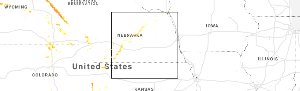
Hail Map for Monday, July 1, 2019
Number of Impacted Households on 7/1/2019
0
Impacted by 1" or Larger Hail
0
Impacted by 1.75" or Larger Hail
0
Impacted by 2.5" or Larger Hail
Square Miles of Populated Area Impacted on 7/1/2019
0
Impacted by 1" or Larger Hail
0
Impacted by 1.75" or Larger Hail
0
Impacted by 2.5" or Larger Hail


Cities Most Affected by Hail Storms of 7/1/2019
| Hail Size | Demographics of Zip Codes Affected | ||||||
|---|---|---|---|---|---|---|---|
| City | Count | Average | Largest | Pop Density | House Value | Income | Age |
| Thermopolis, WY | 3 | 1.83 | 2.00 | 3 | $81k | $29.9k | 49.0 |
| Opheim, MT | 1 | 2.00 | 2.00 | 0 | $21k | $31.5k | 54.6 |
| Manville, WY | 1 | 1.75 | 1.75 | 0 | $48k | $20.9k | 55.1 |
| Lewistown, MT | 1 | 1.75 | 1.75 | 8 | $74k | $30.8k | 47.6 |
| Douglas, WY | 1 | 1.75 | 1.75 | 3 | $88k | $39.7k | 38.0 |
| Melstone, MT | 1 | 1.75 | 1.75 | 0 | $55k | $31.0k | 47.1 |
| Casper, WY | 1 | 1.75 | 1.75 | 14 | $85k | $40.7k | 38.5 |
Hail and Wind Damage Spotted on 7/1/2019
Filter by Report Type:Hail ReportsWind Reports
States Impacted
Wyoming, Missouri, Montana, Colorado, South Dakota, Kansas, Illinois, Kentucky, Minnesota, Nebraska, Tennessee, New Mexico, OhioWyoming
| Local Time | Report Details |
|---|---|
| 1:20 PM MDT | Golf Ball sized hail reported near Thermopolis, WY, 50.1 miles NNW of Riverton, WY |
| 1:42 PM MDT | Golf Ball sized hail reported near Thermopolis, WY, 44 miles N of Riverton, WY |
| 1:49 PM MDT | Hen Egg sized hail reported near Thermopolis, WY, 44 miles N of Riverton, WY, 2 inch hail reported at hot springs state park. |
| 3:24 PM MDT | Quarter sized hail reported near Riverton, WY, 12.9 miles NW of Riverton, WY, lost wells butte quarter size hail |
| 3:40 PM MDT | Quarter sized hail reported near Douglas, WY, 68.9 miles ENE of Casper, WY |
| 3:50 PM MDT | Dime sized hail and heavy rainfall as wel in converse county WY, 59.5 miles ENE of Casper, WY |
| 4:10 PM MDT | Golf Ball sized hail reported near Douglas, WY, 66.3 miles ENE of Casper, WY |
| 4:54 PM MDT | Quarter sized hail reported near Manville, WY, 81.7 miles E of Casper, WY |
| 4:58 PM MDT | Ping Pong Ball sized hail reported near Manville, WY, 78.2 miles E of Casper, WY, corrects previous hail report from 4 nnw keeline. very jagged hail. broken windows and torn siding on residence. |
| 4:58 PM MDT | Quarter sized hail reported near Manville, WY, 78.2 miles E of Casper, WY, very jagged hail. |
| 5:17 PM MDT | Golf Ball sized hail reported near Manville, WY, 82.3 miles NW of Scottsbluff, NE, golf ball hail and multiple small tree branches down. |
| 5:18 PM MDT | Half Dollar sized hail reported near Manville, WY, 80.1 miles NW of Scottsbluff, NE |
| 6:00 PM MDT | Quarter sized hail reported near Lusk, WY, 60.3 miles NW of Scottsbluff, NE |
| 6:00 PM MDT | Storm damage reported in goshen county WY, 60.3 miles NW of Scottsbluff, NE |
| 6:17 PM MDT | Quarter sized hail reported near Torrington, WY, 52.8 miles NW of Scottsbluff, NE |
| 7:00 PM MDT | Alsop mesonet sit in goshen county WY, 31.4 miles NW of Scottsbluff, NE |
| 7:10 PM MDT | Golf Ball sized hail reported near Casper, WY, 11.8 miles SW of Casper, WY, motorist on state highway 220 drove through storm and observed golf ball size hail |
Missouri
| Local Time | Report Details |
|---|---|
| 3:03 PM CDT | Quarter sized hail reported near Saint Louis, MO, 6.5 miles WSW of Saint Louis, MO |
| 3:05 PM CDT | A few 6 to 12 inch diameter tree branches downe in st. louis county MO, 7.1 miles W of Saint Louis, MO |
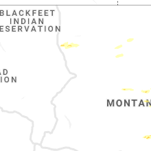
Montana
| Local Time | Report Details |
|---|---|
| 2:36 PM MDT | Golf Ball sized hail reported near Lewistown, MT, 73.8 miles ESE of Great Falls, MT, public reported golf ball size hail. crops damaged. |
| 3:38 PM MDT | Quarter sized hail reported near Larslan, MT, 27.8 miles N of Glasgow, MT, initially started with pea to dime size hail... then a lapse and then hail up to 1 inch fell. total time was about 10 minutes. |
| 4:00 PM MDT | Quarter sized hail reported near Larslan, MT, 32.8 miles NNE of Glasgow, MT, pea to quarter sized hail. 0.6 inch of rain in 15 minutes. |
| 4:30 PM MDT | Hen Egg sized hail reported near Opheim, MT, 39.4 miles NNE of Glasgow, MT, lime sized hail reported on social media with a photo for the corner of baylor rd and zemliska road. time estimated by radar. |
| 5:45 PM MDT | Quarter sized hail reported near Roberts, MT, 43.5 miles SW of Billings, MT |
| 5:45 PM MDT | Half Dollar sized hail reported near Melstone, MT, 66.4 miles NNE of Billings, MT |
| 5:47 PM MDT | Golf Ball sized hail reported near Melstone, MT, 66.3 miles NNE of Billings, MT |
| 6:12 PM MDT | Quarter sized hail reported near Saco, MT, 37.1 miles WNW of Glasgow, MT, estimated 1 inch hail / heavy rain |
| 6:15 PM MDT | Quarter sized hail reported near Fromberg, MT, 33.2 miles SW of Billings, MT, time estimated from radar |
| 6:39 PM MDT | Measured on a davis weather statio in valley county MT, 2.6 miles NNW of Glasgow, MT |
| 7:52 PM MDT | Storm damage reported in roosevelt county MT, 46.3 miles E of Glasgow, MT |
| 8:45 PM MDT | Mesonet station mtcom comertown 6s. time estimated based on radar dat in sheridan county MT, 54.1 miles NNW of Williston, ND |
Colorado
| Local Time | Report Details |
|---|---|
| 3:54 PM MDT | Quarter sized hail reported near Aurora, CO, 7.3 miles ESE of Denver, CO, reported at 132 s juliet circle... aurora... co. |
| 4:27 PM MDT | Storm damage reported in montrose county CO, 52.6 miles SE of Grand Junction, CO |
| 4:44 PM MDT | Storm damage reported in pueblo county CO, 5.1 miles ENE of Pueblo, CO |
| 4:50 PM MDT | Half Dollar sized hail reported near Carr, CO, 46.7 miles SE of Laramie, WY |
| 5:30 PM MDT | Delayed report. multiple 6-12 inch diameter trees blown down at the courthouse. time estimated by rada in pueblo county CO, 1.1 miles N of Pueblo, CO |
| 6:11 PM MDT | Asos station kspd 8 s springfiel in baca county CO, 107 miles WSW of Garden City, KS |
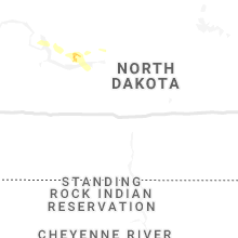
South Dakota
| Local Time | Report Details |
|---|---|
| 5:03 PM CDT | Quarter sized hail reported near Valley Springs, SD, 15.1 miles ENE of Sioux Falls, SD, report via social media of quarter sized hail in booge south dakota. |
Kansas
| Local Time | Report Details |
|---|---|
| 5:05 PM CDT | Quarter sized hail reported near Atwood, KS, 31.2 miles N of Colby, KS, also reported 60 mph winds and possible wind damage. reported received via facebook with pictures and video. |
| 5:05 PM CDT | Also reported quarter size hail. report received via facebook with video of wind gusts and possible damag in rawlins county KS, 31.2 miles N of Colby, KS |
| 4:09 PM MDT | Also pea-sized hai in sherman county KS, 29.1 miles WNW of Colby, KS |
| 5:10 PM CDT | Also reported about dime size hai in rawlins county KS, 33.4 miles N of Colby, KS |
| 5:15 PM CDT | Storm damage reported in rawlins county KS, 28.5 miles N of Colby, KS |
| 4:30 PM MDT | Quarter sized hail reported near Goodland, KS, 29.1 miles WNW of Colby, KS |
| 4:55 PM MDT | Storm damage reported in sherman county KS, 31.9 miles WNW of Colby, KS |
| 5:00 PM MDT | Also reported over 2 inches of rainfall and that a small ditch near this area was about to overfill its bank in sherman county KS, 29.1 miles WNW of Colby, KS |
| 6:40 PM CDT | Storm damage reported in rawlins county KS, 31.6 miles NNW of Colby, KS |
| 8:33 PM CDT | Storm damage reported in stanton county KS, 59.4 miles WSW of Garden City, KS |
Illinois
| Local Time | Report Details |
|---|---|
| 5:09 PM CDT | Quarter sized hail reported near Du Bois, IL, 60.6 miles ESE of Saint Louis, MO |
Kentucky
| Local Time | Report Details |
|---|---|
| 5:15 PM CDT | Several trees and limbs blown down along with part of a barn roof blown off. viewer reports 67 mph gus in carlisle county KY, 42.4 miles SE of Cape Girardeau, MO |
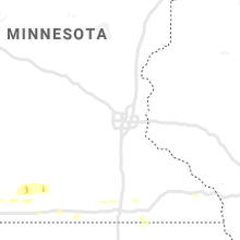
Minnesota
| Local Time | Report Details |
|---|---|
| 5:20 PM CDT | Tree down in park... and numerous large branches down around tow in faribault county MN, 49.2 miles NNW of Mason City, IA |
Nebraska
| Local Time | Report Details |
|---|---|
| 5:35 PM CDT | Ping Pong Ball sized hail reported near Mc Cook, NE, 59.8 miles NNE of Colby, KS, report received via facebook message with a picture. |
| 5:43 PM CDT | Half Dollar sized hail reported near Mc Cook, NE, 59.8 miles NNE of Colby, KS |
| 5:45 PM CDT | Ping Pong Ball sized hail reported near Mc Cook, NE, 62.5 miles S of North Platte, NE, public reported via twitter hail up to ping pong ball size roughly 2 miles north of the mccook airport. |
| 5:45 PM CDT | Quarter sized hail reported near Mc Cook, NE, 59.8 miles NNE of Colby, KS, report received via facebook comment with a picture comparing hail to a quarter. |
| 6:45 PM CDT | Personal weather station knecozad in dawson county NE, 44.9 miles ESE of North Platte, NE |
| 6:46 PM CDT | Shingles blown off a roof. pea size hail as wel in dawson county NE, 45.2 miles ESE of North Platte, NE |
| 7:48 PM MDT | Quarter sized hail reported near Mitchell, NE, 11.6 miles NW of Scottsbluff, NE |
| 8:13 PM MDT | Storm damage reported in scotts bluff county NE, 7.9 miles NNW of Scottsbluff, NE |
Tennessee
| Local Time | Report Details |
|---|---|
| 6:00 PM CDT | Quarter sized hail reported near Union City, TN, 43 miles WNW of Mc Kenzie, TN, hail between the size of a quarter and half dollar along highway 22 between clayton and old freemont. hail also accompanied by winds estimated around 50 mph. |
New Mexico
| Local Time | Report Details |
|---|---|
| 6:40 PM MDT | Mesonet wsmr in otero county NM, 92.1 miles N of El Paso, TX |
Ohio
| Local Time | Report Details |
|---|---|
| 1:18 AM EDT | Several trees downed at a property on swigert road. one tree downed on a hous in warren county OH, 21.9 miles NE of Cincinnati, OH |
| 1:32 AM EDT | Damage to trees off anderson and center road in clinton county OH, 42.7 miles NE of Cincinnati, OH |
Connect with Interactive Hail Maps